National Statistical Office. All rights reserved. The Government Complex,Building B,Chaeng Watthana Rd, Laksi Bangkok Thailand Tel.
|
|
|
- Cameron Gray
- 5 years ago
- Views:
Transcription


1 STAT- GIS of Thailand by Ms. Ruamporn Sirirattrakul i Statistical Geo-Informatics Bureau, National Statistical Office of Thailand National Statistical Office. All rights reserved. The Government Complex,Building B,Chaeng Watthana Rd, Laksi Bangkok Thailand Tel. (66) Information Services: services@nso.go.th Recommendation: webmaster@nso.go.th


2 Integration of Official Statistics and Geospatial data Framework Econom mic & Environ nment Dat ta Layer of Economic data such as - Industry - Building - Hotel And Guest House Base Map shapefile STAT-GIS Social Data Layer of social data such as -Population and demography - Labor -Income and expenditure -Poverty Base Map 7 layers Geospatial Data 1. Google Map : Styled Map, Road Map,Terrain Map,Satellite Map, Hybrid Map, Open Street Map 2. Administrative Boundary ( Region, Province, District, Sub district)
 https://statgis.nso.go.th/d 1.")


 17 Surveys ( ie.")


3 Statistical Geographic Information System (STAT- GIS) 1. Statistical Data Base : 2,800 items in series ( shown by sub district level for Census and Provincial level for survey) classified by Census and Survey Projects 20 Projects 3 Censuses (Population,Agriculture, Business and Industry) 17 Surveys ( ie., Labor Force, socio-economic, Construction Migration, ICT, etc. STAT- GIS Sectoral Statistics 17 sectors : Labor Household Income Education & Expenditure Religion & Culture National Account Health Agriculture & Social welfare Fisheries Gender Industry Trade & Price Transportation & Logistics ICT Tourism & Sports Science, IT & Property Right Natural Resources & Environment


4 EXAMPLE STAT-GIS for STATFLOOD ANALYSIS in SUPHAN BURI PROVINCE


 : - NONGYA")


5 FLOOD MAP in / FLOOD AREA OF SUPHUNBURI PROVINCE in 2011 DESTRICT MAP OF SUPHUN BURI PROVINCE Suphunburi province DOEM BANGNANGBUAT DAN CHANG NONGYA SAI SAM CHUK DONCHEDI SI PRACHAN SUPHUN BURI MUENG UTHONG BANG PLAMA SONG PHINONG Flood Area in Suphunburi Province List of 9 flood districts (out of 10 districts) : - NONGYA SAI - UTHONG - MUENG - SAM CHUK - BANG PLAMA - DONCHEDI - SI PRACHAN - SONG PHINONG - DOEM BANGNANGBUAT 1/ GISTDA
 DESTRICTS BANG NONG SI SONG")
 79,965 48,018 121,205 62,810 128,471 55,441 167,059 43,691 73,012 No.")

 15,543 9,092 24,529 11,153 25,426 9,069 28,793 8,539 12,886 No.")

6 DESTRICT MAP OF SUPHAN BURI PROVINCE FLOOD AREA OF SUPHUN BURI PROVINCE in 2011 Ex. Bangplama District Information BANG PLAMA Flood Area ( Blue area) DESTRICTS BANG NONG SI SONG SAM UTHONG MUENG DON PLAMA YASAI PRACHAN PHINONG CHUK CHEDI DOEM BANGNANG BUAT No. of Population (person) 79,965 48, ,205 62, ,471 55, ,059 43,691 73,012 No. of Households 21,757 15, ,417 19,807 35, ,906 49,883 12,948 22,636 Density of population (person/sq.km. ) Size of household No. of Children (0-14 yrs.) 15,543 9,092 24,529 11,153 25,426 9,069 28,793 8,539 12,886 No. of Working Population (15-59 yrs ) 48,267 30,823 76,789 39,717 83,992 36, ,019 28,023 44,754 No. of Elderly (60 yrs and over) 16,155 8,103 19,887 11,940 19,053 10,168 27,247 7,129 15,372 No. of Business and Industrial establishments 1,292 1,006 2,715 1,671 2,329 1,682 4,930 1,015 1,670


 No.")
 223 8")
 186 9 BAN")
 150 10 BAN")
 145 11 BAN BANG")
 135 12 BAN")
 129 13")
 129 Total")
7 FLOOD AREA OF BANGPLAMA DISTRICT in 2011 Village or Enumeration Area BANG PLAMA BAN KANOMJIN of Bangplama Subdistrict BANG PLAMA BAN HAOPHI BAN SOATONG BAN POSI BAN DONMAKLUEA BAN KOAHONG BAN DEAN 1 3 BAN PHONSI BAN KOKMOUNG BAN KOKMOUNG BAN PHONRI 2 BAN DEAN BAN BANG PLAMA House Location ( White Point ) No village name (EA code) No. of houses No village name (EA code) No. of houses 1 BAN SAOTONG (003) BAN KOKMUANG (002) BAN DAN (008) BAN HAOPHI (005) BAN KOKMUANG (003) BAN KOAHONG (001) 91 4 BAN YOD (001) BAN BANG PLAMA (009) 86 5 BAN PHONSI ( 007) BAN KANOMJIN (002) 85 6 BAN DONMAKUEA (004) BAN PHONRI (010) 65 7 BAN POSI (006) 129 Total 1,648


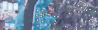

8 FLOOD AREA IN BANGPLAMA DISTRICT in 2011 House affected by flood


9 THANK YOU FOR ATTENTION National Statistical Office. All rights reserved. The Government Complex,Building B,Chaeng Watthana Rd, Laksi Bangkok Thailand Tel. (66) Information Services: Recommendation: 9
System of collecting social statistics
 PHILIPPINES Inception Meeting System of collecting social statistics The Philippines has a decentralized system. It is composed of a policy-making body data producers data users research and training institutions
Understanding China Census Data with GIS By Shuming Bao and Susan Haynie China Data Center, University of Michigan
 Understanding China Census Data with GIS By Shuming Bao and Susan Haynie China Data Center, University of Michigan The Census data for China provides comprehensive demographic and business information
Use of Geospatial Data: Philippine Statistics Authority 1
 Use of Geospatial Data: Philippine Statistics Authority 1 1 Presentation by Lisa Grace S. Bersales at the UNSC 2016 side event on Geospatial information and earth observations: supporting official statistics
GIS (GEOGRAPHICAL INFORMATION SYSTEMS) AS A FACILITATION TOOL FOR SUSTAINABLE DEVELOPMENT IN AFRICA
 AS A FACILITATION TOOL FOR SUSTAINABLE DEVELOPMENT IN AFRICA") GIS (GEOGRAPHICAL INFORMATION SYSTEMS) AS A FACILITATION TOOL FOR SUSTAINABLE DEVELOPMENT IN AFRICA a presentation by Elizabeth Hicken GDEST Conference on Geospatial Sciences for Sustainable Development
GIS (GEOGRAPHICAL INFORMATION SYSTEMS) AS A FACILITATION TOOL FOR SUSTAINABLE DEVELOPMENT IN AFRICA a presentation by Elizabeth Hicken GDEST Conference on Geospatial Sciences for Sustainable Development
Spotlight on Population Resources for Geography Teachers. Pat Beeson, Education Services, Australian Bureau of Statistics
 Spotlight on Population Resources for Geography Teachers Pat Beeson, Education Services, Australian Bureau of Statistics Population Population size Distribution Age Structure Ethnic composition Gender
Presented to Sub-regional workshop on integration of administrative data, big data and geospatial information for the compilation of SDG indicators
 Presented to Sub-regional workshop on integration of administrative data, big data and geospatial information for the compilation of SDG indicators 23-25 April,2018 Addis Ababa, Ethiopia By: Deogratius
Department of Statistics Malaysia
 Department of Statistics Malaysia 1 2 1 2 3 4 5 Introduction Geographic Information Systems (GIS) Geospatial activities for 2020 Modernisation Way Forward 3 Malaysia Population (Millions) Census 2010 2018
Working with Census Operations Case Study from KSA
 Working with Census Operations Case Study from KSA International Workshop on Integrating Geospatial and Statistical Information Beijing 9 12 June 2014 Abdullah M.Alhamlan Kingdom of Saudi Arabia Central
Population Research Center (PRC) Oregon Population Forecast Program
 Oregon Population Forecast Program") Population Research Center (PRC) Oregon Population Forecast Program 2013 Oregon League of Cities Conference Risa S. Proehl Jason R. Jurjevich, Ph.D. Population Research Center (PRC) Population Research
Population Research Center (PRC) Oregon Population Forecast Program 2013 Oregon League of Cities Conference Risa S. Proehl Jason R. Jurjevich, Ph.D. Population Research Center (PRC) Population Research
Qatar Statistical Geospatial Integration
 Qatar Statistical Geospatial Integration A Presentation by the Ministry of Development Planning & Statistics (MDPS), State of Qatar http://www.mdps.gov.qa (Fourth UN-GGIM Arab States Committee Meeting,
European Regional and Urban Statistics
 European Regional and Urban Statistics Dr. Berthold Feldmann berthold.feldmann@ec.europa.eu Eurostat Structure of the talk Regional statistics in the EU The tasks of Eurostat Regional statistics Urban
BRITISH VIRGIN ISLANDS SECTORAL GROSS DOMESTIC PRODUCT MARKET PRICES (current prices) (US$M)
 (US$M)") SECTORAL GROSS DOMESTIC PRODUCT MARKET PRICES (current prices) Sector 1991 1992 1993 1994 1995 1996 1997 1998 1999 2000r 2001r 2002r 2003r 2004r 2005e Agriculture, Hunting & Forestry 1.36 1.50 1.63 1.77
SECTORAL GROSS DOMESTIC PRODUCT MARKET PRICES (current prices) Sector 1991 1992 1993 1994 1995 1996 1997 1998 1999 2000r 2001r 2002r 2003r 2004r 2005e Agriculture, Hunting & Forestry 1.36 1.50 1.63 1.77
Creating synergies between Statistical and Geospatial information for better policy outputs: The case of Mexico
 Creating synergies between Statistical and Geospatial information for better policy outputs: The case of Mexico Geospatial & Statistics Integration for Informed Decision Making Geospatial World Forum 2017
MAPPING DATA AND INFORMATION SYSTEMS AVAILABILITY AGAINST THE SDGs
 MAPPING DATA AND INFORMATION SYSTEMS AVAILABILITY AGAINST THE SDGs Imelda Atai Musana Uganda Bureau of Statistics imelda.atai@ubos.org Date: November 2015 1 Introduction Uganda Lies Astride the Equator
Experience of Mexico in using GIS and spatial
 Experience of Mexico in using GIS and spatial data as a tool for data integration Francisco Javier Jimenez Nava Deputy General Director of Natural Resources and Environment Outline Introduction National
An Introduction to China and US Map Library. Shuming Bao Spatial Data Center & China Data Center University of Michigan
 An Introduction to China and US Map Library Shuming Bao Spatial Data Center & China Data Center University of Michigan Current Spatial Data Services http://chinadataonline.org China Geo-Explorer http://chinageoexplorer.org
Targeting the Poor. Towards evidence-based implementation. Johan A. Mistiaen (World Bank)
") Targeting the Poor Towards evidence-based implementation Johan A. Mistiaen (World Bank) Presentation at Joint Poverty Assessment Workshop Nairobi - May 19, 2005 Outline Integrating Data Sources - GIS What
Targeting the Poor Towards evidence-based implementation Johan A. Mistiaen (World Bank) Presentation at Joint Poverty Assessment Workshop Nairobi - May 19, 2005 Outline Integrating Data Sources - GIS What
Preparing the GEOGRAPHY for the 2011 Population Census of South Africa
 Preparing the GEOGRAPHY for the 2011 Population Census of South Africa Sharthi Laldaparsad Statistics South Africa; E-mail: sharthil@statssa.gov.za Abstract: Statistics South Africa (Stats SA) s Geography
Apéndice 1: Figuras y Tablas del Marco Teórico
 Apéndice 1: Figuras y Tablas del Marco Teórico FIGURA A.1.1 Manufacture poles and manufacture regions Poles: Share of employment in manufacture at least 12% and population of 250,000 or more. Regions:
FINANCIAL PERFORMANCE OF UTTAR PRADESH DURING TENTH PLAN
 FINANCIAL PERFORMANCE OF UTTAR PRADESH DURING TENTH PLAN Sl. Tenth Plan - 2002-07 Projected Annual Plan - 2002-03 Annual Plan - 2003-04 1. 2. 3. 4. 5. 6. 7. 8. 9. I Agriculture & Allied Activities 1. Crop
Achieving the Vision Geo-statistical integration addressing South Africa s Developmental Agenda. geospatial + statistics. The Data Revolution
 Achieving the Vision Geo-statistical integration addressing South Africa s Developmental Agenda geospatial + statistics The Data Revolution humble beginnings, present & future - South Africa UN World Data
UNCERTAINTY IN THE POPULATION GEOGRAPHIC INFORMATION SYSTEM
 UNCERTAINTY IN THE POPULATION GEOGRAPHIC INFORMATION SYSTEM 1. 2. LIU De-qin 1, LIU Yu 1,2, MA Wei-jun 1 Chinese Academy of Surveying and Mapping, Beijing 100039, China Shandong University of Science and
Making space for a more foundational construction sector in Brussels
 Making space for a more foundational construction sector in Brussels Sarah De Boeck, David Bassens & Michael Ryckewaert Social innovation in the Foundational Economy Cardiff, 5 th of September 2018 1.
Egypt Public DSS. the right of access to information. Mohamed Ramadan, Ph.D. [R&D Advisor to the president of CAPMAS]
![Egypt Public DSS. the right of access to information. Mohamed Ramadan, Ph.D. [R&D Advisor to the president of CAPMAS]](/thumbs/89/98483713.jpg "Egypt Public DSS. the right of access to information. Mohamed Ramadan, Ph.D. [R&D Advisor to the president of CAPMAS]") Egypt Public DSS ì the right of access to information Central Agency for Public Mobilization and Statistics Arab Republic of Egypt Mohamed Ramadan, Ph.D. [R&D Advisor to the president of CAPMAS] Egypt
Egypt Public DSS ì the right of access to information Central Agency for Public Mobilization and Statistics Arab Republic of Egypt Mohamed Ramadan, Ph.D. [R&D Advisor to the president of CAPMAS] Egypt
Tropentag 2007 University of Kassel-Witzenhausen and University of Göttingen, October 9-11, 2007
 Tropentag 2007 University of Kassel-Witzenhausen and University of Göttingen, October 9-11, 2007 Conference on International Agricultural Research for Development Sampling for vulnerability to poverty:
Evaluating Community Analyst for Use in School Demography Studies
 Portland State University PDXScholar Publications, Reports and Presentations Population Research Center 7-2013 Evaluating Community Analyst for Use in School Demography Studies Richard Lycan Portland State
Chapter 10 Human Settlement Geography Book 1 Class 12
 CHAPTER 10 HUMAN SETTLEMENTS 1. RURAL, SUB URBAN AND URBAN SETTLEMENTS: This classification is common worldwide but the criteria differ from country to country. 5. Criteria for classification differs from
Geographic Boundaries of Population Census of Japan 1
 UNITED NATIONS SECRETARIAT ESA/STAT/AC.279/P20 Department of Economic and Social Affairs October 2013 Statistics Division English only United Nations Expert Group on the Integration of Statistical and
Use of administrative registers for strengthening the geostatistical framework of the Census of Agriculture in Mexico
 Use of administrative registers for strengthening the geostatistical framework of the Census of Agriculture in Mexico Susana Pérez INEGI, Dirección de Censos y Encuestas Agropecuarias. Avenida José María
COUNTY SPATIAL DATA INFRASTRUCTURE PRESENTATION: BY: GEOFREY CHERUIYOT NAIROBI CITY COUNTY
 . COUNTY SPATIAL DATA INFRASTRUCTURE PRESENTATION: BY: GEOFREY CHERUIYOT NAIROBI CITY COUNTY FRAMEWORK FOR AN INTEGRATED SPATIAL DATA INFRASTRUCTURE County GIS GIS : A computer based information system
Geospatial Technologies for Resources Planning & Management
 Geospatial Technologies for Resources Planning & Management Lal Samarakoon, PhD Director, Geoinformatics Center Asian Institute of Technology, Thailand Content Geoinformatics for SDG Information Integration
Mission Report. Charles Brigham Reese GIS Specialist, UN Statistics Division
 Mission Report on The Geographic Preparatory Activities for the 2010 Population and Housing Census of Sri Lanka United Nations Statistics Division (22 24 September 2008) By Charles Brigham Reese GIS Specialist,
CENSUS MAPPING WITH GIS IN NAMIBIA. BY Mrs. Ottilie Mwazi Central Bureau of Statistics Tel: October 2007
 CENSUS MAPPING WITH GIS IN NAMIBIA BY Mrs. Ottilie Mwazi Central Bureau of Statistics E-mail: omwazi@npc.gov.na Tel: + 264 61 283 4060 October 2007 Content of Presentation HISTORICAL BACKGROUND OF CENSUS
JIRAKIATTIKUL Sopin. Committee member and resource person of the Southern Woman Group, 1995 to 1998
 JIRAKIATTIKUL Sopin Faculty of Economics Prince of Songkla University Had Yai, Songkhla 90112 THAILAND e-mail: sopin.j@psu.ac.th FACULTY APPOINTMENTS Associate Dean for Academic Affairs (Acting) November,
Section III: Poverty Mapping Results
 Section III: Poverty Mapping Results Figure 5: Gewog level rural poverty map 58. The most prominent result from the poverty mapping exercise of Bhutan is the production of a disaggregated poverty headcount
Measuring Disaster Risk for Urban areas in Asia-Pacific
 Measuring Disaster Risk for Urban areas in Asia-Pacific Acknowledgement: Trevor Clifford, Intl Consultant 1 SDG 11 Make cities and human settlements inclusive, safe, resilient and sustainable 11.1: By
MALDIVES. Regional Expert Workshop On Land Accounting For SDG Monitoring & Reporting (25-27 th Sept 2017) - Fathimath Shanna, Aishath Aniya -
 - Fathimath Shanna, Aishath Aniya -") MALDIVES Regional Expert Workshop On Land Accounting For SDG Monitoring & Reporting (25-27 th Sept 2017) - Fathimath Shanna, Aishath Aniya - ABOUT MALDIVES Approximately 860 km long and 120 km wide Consists
MALDIVES Regional Expert Workshop On Land Accounting For SDG Monitoring & Reporting (25-27 th Sept 2017) - Fathimath Shanna, Aishath Aniya - ABOUT MALDIVES Approximately 860 km long and 120 km wide Consists
Spatial Statistical Information Services in KOSTAT
 Distr. GENERAL WP.30 12 April 2010 ENGLISH ONLY UNITED NATIONS ECONOMIC COMMISSION FOR EUROPE (UNECE) CONFERENCE OF EUROPEAN STATISTICIANS EUROPEAN COMMISSION STATISTICAL OFFICE OF THE EUROPEAN UNION (EUROSTAT)
Use of registers in statistical geospatial integration
 Use of registers in statistical geospatial integration Trevor Sutton Deputy Australian Statistician Statistical Business Transformation Australian Bureau of Statistics March 2016 Role of registers in the
Climate Change Vulnerability Assessment in Thailand. Kampanart PiyathamrongchaI Naresuan University
 Climate Change Vulnerability Assessment in Thailand Kampanart PiyathamrongchaI Naresuan University Outline Background Objectives Concept and technique to assess climate change vulnerability Discussion
Socio-Economic Atlas of Tajikistan. The World Bank THE STATE STATISTICAL COMMITTEE OF THE REPUBLIC OF TAJIKISTAN
 Socio-Economic Atlas of Tajikistan The World Bank THE STATE STATISTICAL COMMITTEE OF THE REPUBLIC OF TAJIKISTAN 1) Background Why there is a need for socio economic atlas? Need for a better understanding
Challenges and Potentials of Place Based Information Management in Nepal"
 Nineteenth United Nations Regional Cartographic Conference for Asia and the Pacific, Bangkok, Thailand, 29 October 1 November 2012 Challenges and Potentials of Place Based Information Management in Nepal"
A User s Guide to the Federal Statistical Research Data Centers
 A User s Guide to the Federal Statistical Research Data Centers Mark Roberts Professor of Economics and Director PSU FSRDC September 2016 M. Roberts () RDC User s Guide September 2016 1 / 14 Outline Introduction
Integrating Official Statistics and Geospatial Information NBS Experience
 Integrating Official Statistics and Geospatial Information NBS Experience Presented by Eng. Reda AL Sabbagh Director of IT Dept. Prepared by Eng. Adham Makky GIS Specialist Topics to be covered: Background
Oregon Population Forecast Program
 Oregon Population Forecast Program Regional Forecast Meeting October 2, 2015 Presentation by Population Forecast Program Team Hood River County Oregon Population Forecast Program Project Team Xiaomin Ruan,
Globally Estimating the Population Characteristics of Small Geographic Areas. Tom Fitzwater
 Globally Estimating the Population Characteristics of Small Geographic Areas Tom Fitzwater U.S. Census Bureau Population Division What we know 2 Where do people live? Difficult to measure and quantify.
Environmental Analysis, Chapter 4 Consequences, and Mitigation
 Environmental Analysis, Chapter 4 4.17 Environmental Justice This section summarizes the potential impacts described in Chapter 3, Transportation Impacts and Mitigation, and other sections of Chapter 4,
SOFTWARE ARCHITECTURE DESIGN OF GIS WEB SERVICE AGGREGATION BASED ON SERVICE GROUP
 SOFTWARE ARCHITECTURE DESIGN OF GIS WEB SERVICE AGGREGATION BASED ON SERVICE GROUP LIU Jian-chuan*, YANG Jun, TAN Ming-jian, GAN Quan Sichuan Geomatics Center, Chengdu 610041, China Keywords: GIS; Web;
Operational Definitions of Urban, Rural and Urban Agglomeration for Monitoring Human Settlements
 Operational Definitions of Urban, Rural and Urban Agglomeration for Monitoring Human Settlements By Markandey Rai United Nations Human Settlements Programme PO Box-30030 Nairobi, Kenya Abstract The United
Available online at I-SEEC Proceeding - Science and Engineering (2013)
") Available online at www.iseec2012.com I-SEEC 2012 Proceeding - Science and Engineering (2013) 409 415 Proceeding Science and Engineering www.iseec2012.com Science and Engineering Symposium 4 th International
Available online at www.iseec2012.com I-SEEC 2012 Proceeding - Science and Engineering (2013) 409 415 Proceeding Science and Engineering www.iseec2012.com Science and Engineering Symposium 4 th International
GDDS2: GIS AND SMALL AREA STATISTICS. Page 1 of 6
 GDDS2: GIS AD SMALL AREA STATISTICS GDDS2: CHECKLIST Ghana GHAA: AEXURE C Background ame of country Ghana Size of population 21m % of population in urban App 60% Size of country (sq km) 238533 sqkm Geographical
Spatial Planning and Territorial Development at the Regional Level
 Spatial Planning and Territorial Development at the Regional Level Vincent Nadin University of the West of England, UK Spatial Planning and Territorial Development at the Regional Level Vincent Nadin University
A Case Study of Regional Dynamics of China 中国区域动态案例研究
 A Case Study of Regional Dynamics of China 中国区域动态案例研究 Shuming Bao Spatial Data Center & China Data Center University of Michigan 1:00 PM - 2:00 PM, Tue, Feb 6, 2018 EST USA A Case Study of Regional Dynamics
Methodological issues in the development of accessibility measures to services: challenges and possible solutions in the Canadian context
 Methodological issues in the development of accessibility measures to services: challenges and possible solutions in the Canadian context Alessandro Alasia 1, Frédéric Bédard 2, and Julie Bélanger 1 (1)
GIS as a tool for rural livelihoods enhancement planning
 GIS as a tool for rural livelihoods enhancement planning (Case study of Alosylat region -Shareg Alnil-Sudan) Almojtaba M. H. Hassabo Federal Ministry of Agriculture Sudan A research submitted to the Development
Opportunities and challenges of HCMC in the process of development
 Opportunities and challenges of HCMC in the process of development Lê Văn Thành HIDS HCMC, Sept. 16-17, 2009 Contents The city starting point Achievement and difficulties Development perspective and goals
Assessing Social Vulnerability to Biophysical Hazards. Dr. Jasmine Waddell
 Assessing Social Vulnerability to Biophysical Hazards Dr. Jasmine Waddell About the Project Built on a need to understand: The pre-disposition of the populations in the SE to adverse impacts from disaster
BROOKINGS May
 Appendix 1. Technical Methodology This study combines detailed data on transit systems, demographics, and employment to determine the accessibility of jobs via transit within and across the country s 100
CLLD Cooperation OFFER
 Title of the proposed project (English) CLLD Cooperation OFFER PARKS PROTECTION III - Management, Protection and Economic Development in Protected Areas Type of project (select as many as you want) Cooperation
Introductory Seminar Ⅰ Humans and Society in the Age of Internationalization. French(Beginner)Ⅱ. French(Basic)Ⅱ. German(Beginner)Ⅱ.
Ⅱ. French(Basic)Ⅱ. German(Beginner)Ⅱ.") Liberal Arts Education -Compulsory Elective Subjects -Elective Subjects Subject Humankind and Culture SubjectsHumankind Humankind and Society Subjects Nature and the Environment Subjects Liberal Arts Seminars
Liberal Arts Education -Compulsory Elective Subjects -Elective Subjects Subject Humankind and Culture SubjectsHumankind Humankind and Society Subjects Nature and the Environment Subjects Liberal Arts Seminars
Poverty Mapping, Policy Making and Operations
 Poverty Mapping, Policy Making and Operations Some Applications from Kenya (DECDG) Using Poverty Maps to Design Better Policies and Interventions Washington DC May 11, 2006 Outline Poverty Mapping process
DISCOVERING AND ACCESSING SOCIAL SCIENCE DATA OF EAST ASIAN COUNTRIES: TRENDS AND OBSTACLES
 DISCOVERING AND ACCESSING SOCIAL SCIENCE DATA OF EAST ASIAN COUNTRIES: TRENDS AND OBSTACLES JUNGWON YANG UNIVERISTY OF MICHIGAN IASSIST CONFERENCE 2014 Interdisciplinary Studies in Social Science The increasing
Merging statistics and geospatial information
 Merging statistics and geospatial information Demography / Commuting / Spatial planning / Registers Mirosław Migacz Chief GIS Specialist Janusz Dygaszewicz Director Central Statistical Office of Poland
Facilitating Survey Sampling in Low- and Middle-Income Contexts Through Satellite Maps and Basic Mobile Computing Technology
 Facilitating Survey Sampling in Low- and Middle-Income Contexts Through Satellite Maps and Basic Mobile Computing Technology 6 th European Survey Association Conference Survey Research in Developing Countries
Trip Generation Model Development for Albany
 Trip Generation Model Development for Albany Hui (Clare) Yu Department for Planning and Infrastructure Email: hui.yu@dpi.wa.gov.au and Peter Lawrence Department for Planning and Infrastructure Email: lawrence.peter@dpi.wa.gov.au
Combining Geospatial and Statistical Data for Analysis & Dissemination
 Combining Geospatial and Statistical Data for Analysis & Dissemination (with Special Reference to Qatar Census 2010) Presentation by Mansoor Al Malki, Director of IT Department Qatar Statistics Authority
R E SEARCH HIGHLIGHTS
 Canada Research Chair in Urban Change and Adaptation R E SEARCH HIGHLIGHTS Research Highlight No.8 November 2006 THE IMPACT OF ECONOMIC RESTRUCTURING ON INNER CITY WINNIPEG Introduction This research highlight
Topic 4: Changing cities
 Topic 4: Changing cities Overview of urban patterns and processes 4.1 Urbanisation is a global process a. Contrasting trends in urbanisation over the last 50 years in different parts of the world (developed,
Welcome. C o n n e c t i n g
 Welcome C o n n e c t i n g YOU D i s c i p l i n e s Why is This Meeting......So Important Now? OUR WORLD Is Increasingly Challenged The Evidence Is Clear We Need Better Understanding and More Collaboration
Excel Geomatics. Rajesh Paul Excel Geomatics Pvt. Ltd., Noida February, 2015 India Geospatial Forum, Hyderabad
 Excel Geomatics Geo-marketing for Product Sales and Customer Services Rajesh Paul Excel Geomatics Pvt. Ltd., Noida 10-12 February, 2015 India Geospatial Forum, Hyderabad Presentation Outline About Excel
CONSTRUCTING THE POVERTY AND OPPORTUNITIES/PUBLIC SERVICES MAPS INFORMATION MANAGEMENT. Background: Brazil Without Extreme Poverty Plan
 INFORMATION MANAGEMENT CONSTRUCTING THE POVERTY AND OPPORTUNITIES/PUBLIC SERVICES MAPS Background: Brazil Without Extreme Poverty Plan The Brazil Without Extreme Poverty Plan (BSM), designed to overcome
The Efforts of Building GIS Infrastructure in a Newly Independent State: The case of Timor Leste *
 UNITED NATIONS E/CONF.100/IP.12 ECONOMIC AND SOCIAL COUNCIL Eighteenth United Nations Regional Cartographic Conference for Asia and the Pacific Bangkok, 26-29 October 2009 Item 7(b) of the provisional
Cook Islands Household Expenditure Survey
 National Data Archive Cook Islands - 2005-06 Household Expenditure Survey Cook Islands Statistics Office - Ministry of Finance and Economic Management Report generated on: August 19, 2013 Visit our data
Country Report.
 Country Report www.statsfiji.gov.fj Communication and Advocacy for Agriculture and Rural Statistics 27 June -01 July, 2016, Daejeon, Republic of Korea Outline Brief Introduction National Statistical System
Government GIS and its Application for Decision Support
 Government GIS and its Application for Decision Support Zhang Qingpu (Chinese Academy of Surveying and Mapping, Email: zhangqp@casm.ac.cn) Abstract: Application of GIS in government agencies is called
MAKING PLANNING LOCAL
 Georgia Social Vulnerability Index 2010 Atlas MAKING PLANNING LOCAL VULNERABLE & AT-RISK POPULATIONS DATA FOR JURISDICTIONS AT THE CENSUS TRACT LEVEL Public Health Districts Regional Coordinating Hospital
SPATIAL ANALYSIS OF POPULATION DATA BASED ON GEOGRAPHIC INFORMATION SYSTEM
 SPATIAL ANALYSIS OF POPULATION DATA BASED ON GEOGRAPHIC INFORMATION SYSTEM Liu, D. Chinese Academy of Surveying and Mapping, 16 Beitaiping Road, Beijing 100039, China. E-mail: liudq@casm.ac.cn ABSTRACT
Medical GIS: New Uses of Mapping Technology in Public Health. Peter Hayward, PhD Department of Geography SUNY College at Oneonta
 Medical GIS: New Uses of Mapping Technology in Public Health Peter Hayward, PhD Department of Geography SUNY College at Oneonta Invited research seminar presentation at Bassett Healthcare. Cooperstown,
Uganda - National Panel Survey
 Microdata Library Uganda - National Panel Survey 2013-2014 Uganda Bureau of Statistics - Government of Uganda Report generated on: June 7, 2017 Visit our data catalog at: http://microdata.worldbank.org
Demographic Data in ArcGIS. Harry J. Moore IV
 Demographic Data in ArcGIS Harry J. Moore IV Outline What is demographic data? Esri Demographic data - Real world examples with GIS - Redistricting - Emergency Preparedness - Economic Development Next
Urbanization Inside the City 2
 DATES TO REMEMBER COURSE EVALUATION PERIOD OPEN to Dec. 20. Sign in with your Hunter NetID and password Check your Hunter email account for notice from the Dean of Students. TODAY, Mon., Dec 12: Last class
CHANGES IN THE STRUCTURE OF POPULATION AND HOUSING FUND BETWEEN TWO CENSUSES 1 - South Muntenia Development Region
 TERITORIAL STATISTICS CHANGES IN THE STRUCTURE OF POPULATION AND HOUSING FUND BETWEEN TWO CENSUSES 1 - South Muntenia Development Region PhD Senior Lecturer Nicu MARCU In the last decade, a series of structural
Conducting Fieldwork and Survey Design
 Conducting Fieldwork and Survey Design (Prepared for Young South Asian Scholars Participating in SARNET Training Programme at IHD) Dr. G. C. Manna Structure of Presentation Advantages of Sample Surveys
Use of GIS in road sector analysis
 Use of GIS in road sector analysis Uwe Deichmann, DECRG March 30, 2007 Transport Forum and Learning Week 2007 Transport Measurement Matters Indicators of Performance and Impact Geographic information Using
The international patterns of spatial planning system and choice of China. Cai yumei China land use planning and surveying institute (China, beijing)
") FIG Working Week, Rome, Italy 6 10 May 2012 The international patterns of spatial system and choice of China Cai yumei China land use and surveying institute (China, beijing) Outline Background Problem
FIG Working Week, Rome, Italy 6 10 May 2012 The international patterns of spatial system and choice of China Cai yumei China land use and surveying institute (China, beijing) Outline Background Problem
GIS Geographical Information Systems. GIS Management
 GIS Geographical Information Systems GIS Management Difficulties on establishing a GIS Funding GIS Determining Project Standards Data Gathering Map Development Recruiting GIS Professionals Educating Staff
Nordic Council of Ministers Grant Programme for Nordic-Baltic Non-Governmental Organisations (NGO) Cooperation 2019 Estonia.
 Cooperation 2019 Estonia.") Nordic Council of Ministers Grant Programme for Nordic-Baltic Non-Governmental Organisations (NGO) Cooperation 2019 Estonia Automatically saved at 15:54 Basic info Step 1 Project Step 2 Partners Step 3
Nordic Council of Ministers Grant Programme for Nordic-Baltic Non-Governmental Organisations (NGO) Cooperation 2019 Estonia Automatically saved at 15:54 Basic info Step 1 Project Step 2 Partners Step 3
GIS and the Tourism Industry
 GIS and the Tourism Industry Dan Ake GIS Specialist SEDA - Council of Governments 201 Furnace Rd Lewisburg, PA 17837 www.seda-cog.org What are we going to talk about? The tourism industry GIS use in the
Utilizing Data from American FactFinder with TIGER/Line Shapefiles in ArcGIS
 Utilizing Data from American FactFinder with TIGER/Line Shapefiles in ArcGIS Web Adams, GISP Data Dissemination Specialist U.S. Census Bureau New York Regional Office 1 What We Do Decennial Census Every
Impact Evaluation of Rural Road Projects. Dominique van de Walle World Bank
 Impact Evaluation of Rural Road Projects Dominique van de Walle World Bank Introduction General consensus that roads are good for development & living standards A sizeable share of development aid and
Useful Datasets for Development Economics Research
 Useful Datasets for Development Economics Research The Harvard community has made this article openly available. Please share how this access benefits you. Your story matters Citation Nikolov, Plamen.
National Cartographic Center
 National Cartographic Center NCC activities and accomplishments Activities of national organizations, institutions and universities in field of geomatics Large scale maps Medium scale maps Small scale
CBMS. Replication of CBMS in Dodoma Municipality: Towards Scaling Up and Institutionalization of the System in Tanzania
 CBMS 6th PEP Research Network General Meeting Sheraton Lima Hotel, Paseo dela Republica 170 Lima, Peru June 14-16, 2007 Replication of CBMS in Dodoma Municipality: Towards Scaling Up and Institutionalization
Notes On: Do Television and Radio Destroy Social Capital? Evidence from Indonesian Village (Olken 2009)
") Notes On: Do Television and Radio Destroy Social Capital? Evidence from Indonesian Village (Olken 2009) Increasing interest in phenomenon social capital variety of social interactions, networks, and groups
Notes On: Do Television and Radio Destroy Social Capital? Evidence from Indonesian Village (Olken 2009) Increasing interest in phenomenon social capital variety of social interactions, networks, and groups
Statistical and Geospatial
 10 Oct 2014 Statistical and Geospatial Information in Japan Naoki Makita (Mr.), National Statistics Centre, Japan Tomoo Asakawa (Mr.), Statistical Bureau of Japan Day 3 Plenary Session 7 Theme 3 Topic:
Second High Level Forum on GGIM Seminar on Regional Cooperation in Geospatial Information Management Doha, Qatar, 7 February 2013
 Second High Level Forum on GGIM Seminar on Regional Cooperation in Geospatial Information Management Doha, Qatar, 7 February 2013 Overview on Geospatial Activities in Egypt BY : Eng.Nahla Seddik Mohamed
Spatial Disparities and Development Policy in the Philippines
 Spatial Disparities and Development Policy in the Philippines Arsenio M. Balisacan University of the Philipppines Diliman & SEARCA Email: arsenio.balisacan@up.edu.ph World Development Report 2009 (Reshaping
Discerning sprawl factors of Shiraz city and how to make it livable
 Discerning sprawl factors of Shiraz city and how to make it livable 1. Introduction: Iran territory has now been directly affected by urban land-uses which are shaping landscapes in cities and around them.
Brazil Paper for the. Second Preparatory Meeting of the Proposed United Nations Committee of Experts on Global Geographic Information Management
 Brazil Paper for the Second Preparatory Meeting of the Proposed United Nations Committee of Experts on Global Geographic Information Management on Data Integration Introduction The quick development of
Georeferencing and Satellite Image Support: Lessons learned, Challenges and Opportunities
 Georeferencing and Satellite Image Support: Lessons learned, Challenges and Opportunities Shirish Ravan shirish.ravan@unoosa.org UN-SPIDER United Nations Office for Outer Space Affairs (UNOOSA) UN-SPIDER