Understanding the effects of roads in upland settings on hydrology, geomorphology and water quality
|
|
|
- Brianne Hardy
- 5 years ago
- Views:
Transcription
1 Understanding the effects of roads in upland settings on hydrology, geomorphology and water quality Beverley Wemple Department of Geography and Rubenstein School of Environment & Natural Resources The University of Vermont Replumbing the Chesapeake Bay Watershed Workshop Easton, MD October 9-10, 2014
2

3

4 (Wemple and Jones, 2003)
5
6
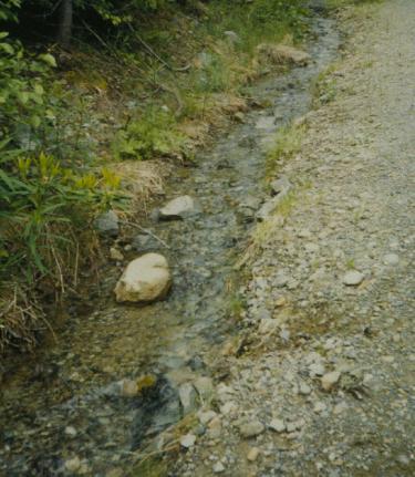
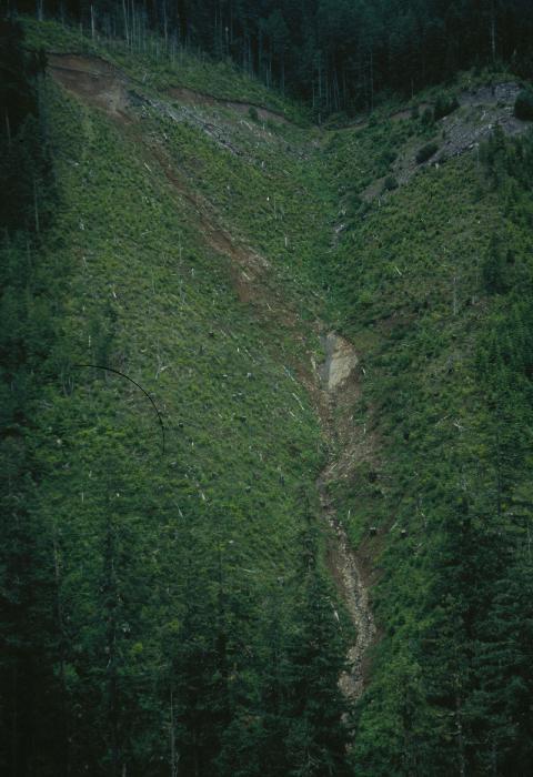
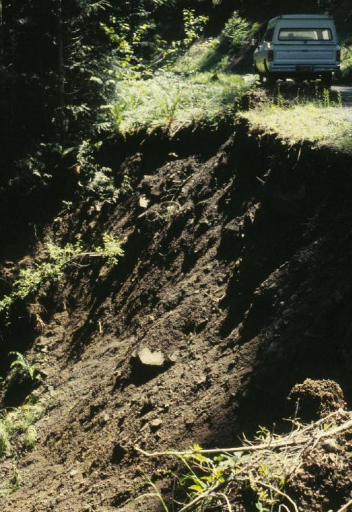
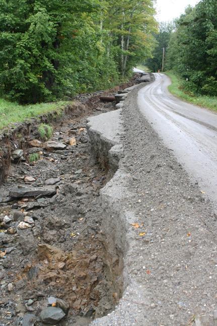
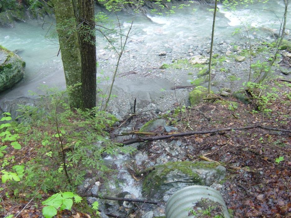
 Highly integrated into the channel network (gullying, debris")
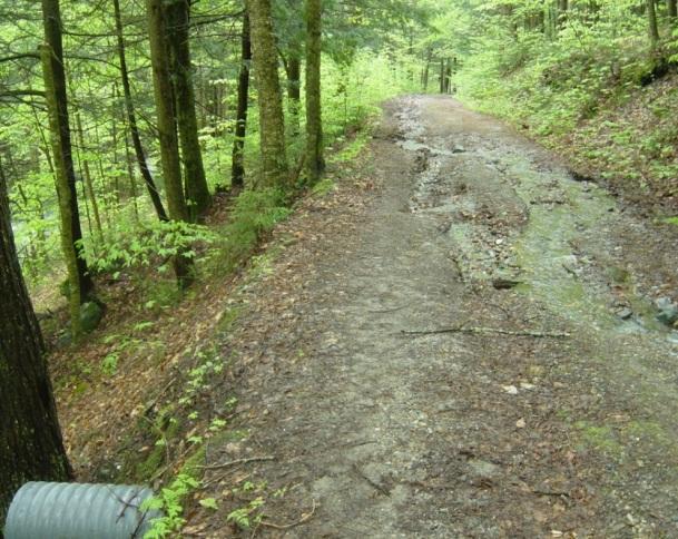
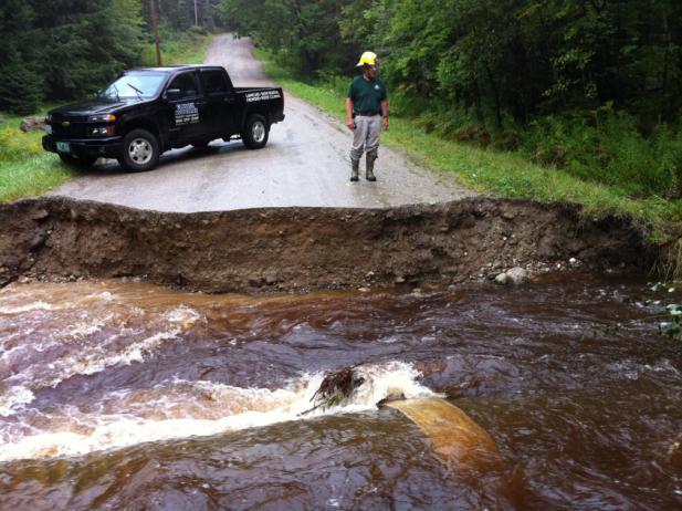
7 (Logging) Roads in upland settings Impervious surfaces in an otherwise pervious landscape (overland flow production) Effectively rearrange flow paths (subsurface flow interception) Highly integrated into the channel network (gullying, debris slides)


8 Context: Lake Champlain Basin

9

10 Conceptual Material Budget Agricultural fields Gravel roads (forested) Hillslopes Lake Champlain Winooski R Sed: 473 kg/ha/yr, P: 0.5 kg/ha/yr Eroding stream banks Urban / Suburban lands lowlands uplands


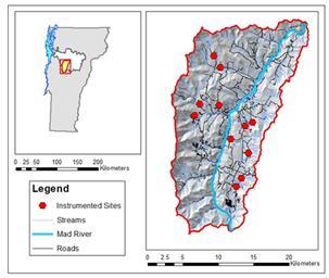
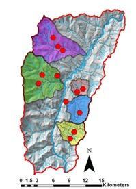
11 Research approach Storm-based monitoring of runoff and water quality GIS mapping and analysis of stream geomorphic assessments Field inventories of road erosion Experimental installation and monitoring of BMPs with cooperating towns

 Winooski basin")
")
12 Study sites and scales of investigation Lake Champlain basin (21000 km 2 ) Winooski basin (2800 km 2 ) Mad River watershed (373 km 2 )


 Volume")
13 Road erosion inventory Erosional feature frequency (#/km) Volume of eroded sediment (m 3 /km)
14 Inventory Results
 Percentage of sediment eroded from roads (40357")
15 Sediment from roads Percentage of unpaved road network (2510 km) Percentage of sediment eroded from roads (40357 Mg)

16 Sample TSS (mg/l) and std error Sample TP (ug/l) and std error Community-based WQ monitoring Freeman Folsom High BridgeMill Brook Shepard 0 Freeman Folsom High BridgeMill Brook Shepard
17 Storm-based monitoring & sampling
 (69 m) (27")
18 Road segment dynamics (240 m) (228 m) Sharpshooter No. Fayston Bragg Hill Mansfield Barton (76 m) (69 m) (27 m)

19 Mass Flux from roads


20 Network connectivity

21 Mass Flux: Roads vs. Streams Suspended Sediment Total Phosphorus

22


23 Geomorphic Assessments, Vermont River Management Program Images courtesy of Vermont Rivers Program, Agency of Natural Resources
 along reach corridor Downstream-most assessed reach 102 reaches Pechenick")
24 Study reaches Forest cover > 75% No impoundments, railroads, history of dredging/gravel mining, development (other than roads) along reach corridor Downstream-most assessed reach 102 reaches Pechenick et al., 2014
25 Scales and metrics of road impact Scales/regions Reach corridor Reach direct drainage River network corridor Catchment Metrics Density Proximity Orientation
26 Road-stream crossings in direct drainage (N/km 2 ) Density metrics of channel condition Geomorphic condition

27 Sum of distance (m), stream to nearest road in reach corridor Proximity metrics of channel condition Normalized by stream length Geomorphic condition
28 SUMMARY: Inventories identify nature and location of road impacts to waterways Coupled water quality monitoring of ditches and receiving waters allows identification of relative importance of roads on water quality Geomorphic assessments allow identification of downstream impacts Improved understanding of how & where roads impact waterways helps inform mitigation measures

29 Acknowledgements Collaborators: - Don Ross, Dept of Plant & Soil Science, UVM - Donna Rizzo, Environmental Engineering, UVM - Leslie Morrissey, Rubenstein School, UVM Students and technicians: G Clark, J Garton, K Garvey, S Hamshaw, A Larson, H Schmid, A Pechenick, C Webster, R Zeyzus Funding Sources: - US EPA and New England Interstate Water Pollution Control Commission - VT DEC Ecosystem Restoration Program - Northeastern States Research Cooperative (Theme 1) - U.S. Geological Survey (NIWR)
30 For More Information: Lake Champlain Basin Program report: Northeastern States Research Cooperative: UVM Blog site for BMP study:
Stream Geomorphology. Leslie A. Morrissey UVM July 25, 2012
 Stream Geomorphology Leslie A. Morrissey UVM July 25, 2012 What Functions do Healthy Streams Provide? Flood mitigation Water supply Water quality Sediment storage and transport Habitat Recreation Transportation
Figure 0-18: Dendrogeomorphic analysis of streambank erosion and floodplain deposition (from Noe and others, 2015a)
") Appendix 9A: Stream to River During the development of the Phase 6 Watershed Model, multiple methods for determining coefficients were often attempted. In some cases, the methods are averaged or otherwise
Appendix 9A: Stream to River During the development of the Phase 6 Watershed Model, multiple methods for determining coefficients were often attempted. In some cases, the methods are averaged or otherwise
Sediment and nutrient transport and storage along the urban stream corridor
 Sediment and nutrient transport and storage along the urban stream corridor Greg Noe, Cliff Hupp, Ed Schenk, Jackie Batson, Nancy Rybicki, Allen Gellis What is the role of floodplains everywhere? Noe 2013,
Monitoring Headwater Streams for Landscape Response to
 Monitoring Headwater Streams for Landscape Response to Climate Change Matthew Connor, PhD Connor nvironmental, nc. www.oe-i.com icom Healdsburg, California verview Headwater stream geomorphology Response
low turbidity high turbidity
 What is Turbidity? Turbidity refers to how clear the water is. The greater the amount of total suspended solids (TSS) in the water, the murkier it appears and the higher the measured turbidity. Excessive
Nutrient and Sediment Cycling and Retention in Urban Floodplain Wetlands
 Nutrient and Sediment Cycling and Retention in Urban Floodplain Wetlands Greg Noe, Cliff Hupp, Nancy Rybicki, Ed Schenk, and Jackie Batson National Research Program, Reston VA U.S. Department of the Interior
Watershed concepts for community environmental planning
 Purpose and Objectives Watershed concepts for community environmental planning Dale Bruns, Wilkes University USDA Rural GIS Consortium May 2007 Provide background on basic concepts in watershed, stream,
Legacy Sediment in the Piedmont: Past valley aggradation, modern stream erosion, and implications for stream water quality
 Funding provided by grants from: NC WRRI (Grant # 2010-70254), Geological Society of America, Sigma Xi, and NCSU Undergrad Research funds Legacy Sediment in the Piedmont: Past valley aggradation, modern
Distinct landscape features with important biologic, hydrologic, geomorphic, and biogeochemical functions.
 1 Distinct landscape features with important biologic, hydrologic, geomorphic, and biogeochemical functions. Have distinguishing characteristics that include low slopes, well drained soils, intermittent
PHASE 1 STREAM GEOMORPHIC ASSESSMENT. Castleton River, Rutland County Vermont. Final Report
 PHASE 1 STREAM GEOMORPHIC ASSESSMENT Castleton River, Rutland County Vermont Final Report September 15, 2005 TABLE OF CONTENTS INTRODUCTION.. 3 STUDY AREA BACKGROUND... 5 METHODOLOGY 5 DATA INPUTS/STUDY
Development and Land Use Change in the Central Potomac River Watershed. Rebecca Posa. GIS for Water Resources, Fall 2014 University of Texas
 Development and Land Use Change in the Central Potomac River Watershed Rebecca Posa GIS for Water Resources, Fall 2014 University of Texas December 5, 2014 Table of Contents I. Introduction and Motivation..4
Wetland & Floodplain Functional Assessments and Mapping To Protect and Restore Riverine Systems in Vermont. Mike Kline and Laura Lapierre Vermont DEC
 Wetland & Floodplain Functional Assessments and Mapping To Protect and Restore Riverine Systems in Vermont Mike Kline and Laura Lapierre Vermont DEC NWI+ Hydro-Geomorphic Characterization of Wetlands and
Conservation Planning evaluate land management alternatives to reduce soil erosion to acceptable levels. Resource Inventories estimate current and
 Conservation Planning evaluate land management alternatives to reduce soil erosion to acceptable levels. Resource Inventories estimate current and projected erosion levels and their impact on natural resource
STREAM SEDIMENT MONITORING PROGRAM FOR ILLINOIS. Nani G. Bhowmik and J. Rodger Adams
 STREAM SEDIMENT MONITORING PROGRAM FOR ILLINOIS By Nani G. Bhowmik and J. Rodger Adams Illinois State Water Survey 2201 Griffith Drive Champaign, IL 61820 August 1985 STREAM SEDIMENT MONITORING PROGRAM
APPENDIX PHASE 1 GREEN INFRASTRUCTURE FRAMEWORK
 APPENDIX PHASE 1 GREEN INFRASTRUCTURE FRAMEWORK KANSAS MISSOURI CONTENTS A DATA WISHLIST 4 B PRECEDENTS 7 C WORKSHOP MATERIALS 13 D ANALYSIS PROCESS 124 E ATLAS & PLAYBOOK DETAILS 156 F POLICY ANALYSIS
Date of Report: EPA agreement number: Center Name and Institution of Ctr. Director: Identifier used by Center for Project: Title of Project:
 Date of Report: March 31, 2003 EPA agreement number: R829515C003 Center Name and Institution of Ctr. Director: Rocky Mountain Regional Hazardous Substance Research Center, Colorado State University, Fort
Curriculum Vitae. Assistant Professor. Department of Geography, University of Vermont, Burlington, VT
 Curriculum Vitae Beverley C. Wemple Associate Professor, Department of Geography University of Vermont, Old Mill 202, Burlington, VT 05405 voice: 802-656-2074 fax: 802-656-3042 email: bwemple@uvm.edu EDUCATION:
Curriculum Vitae. Assistant Professor. Department of Geography, University of Vermont, Burlington, VT
 Curriculum Vitae Beverley C. Wemple Associate Professor, Department of Geography University of Vermont, Old Mill 208, Burlington, VT 05405 voice: 802-656-2074 fax: 802-656-3042 email: bwemple@uvm.edu EDUCATION:
How Do Human Impacts and Geomorphological Responses Vary with Spatial Scale in the Streams and Rivers of the Illinois Basin?
 How Do Human Impacts and Geomorphological Responses Vary with Spatial Scale in the Streams and Rivers of the Illinois Basin? Bruce Rhoads Department of Geography University of Illinois at Urbana-Champaign
Great Lakes Tributary Modeling: Canaseraga Creek Watershed
 Great Lakes Tributary Modeling: Canaseraga Creek Watershed SWAT Model Authority: Section 516(e) of WRDA 1996 US Army Corps of Engineers Canaseraga Creek Project Location - Encompasses portions of Livingston,
Heather Schlosser Army Corps of Engineers Coastal Studies Group August 28, 2008
 Got sand? Regional Sediment Management in Orange County Heather Schlosser Army Corps of Engineers Coastal Studies Group August 28, 2008 Regional Sediment Management Regional sediment management recognizes
Watershed Conservation Management Planning Using the Integrated Field & Channel Technology of AnnAGNPS & CONCEPTS
 Watershed Conservation Management Planning Using the Integrated Field & Channel Technology of AnnAGNPS & CONCEPTS Eddy Langendoen Ron Bingner USDA-ARS National Sedimentation Laboratory, Oxford, Mississippi
VT EPSCoR Streams Project: Highlights & Future Plans. Streams Project Symposium April 27, 2009
 VT EPSCoR Streams Project: Highlights & Future Plans Streams Project Symposium April 27, 2009 What is the Streams Project? Collaborative effort by high schools, colleges and community partners around the
Patrick Baskfield. Scott Matteson. Minnesota Pollution Control Agency. Minnesota State University Water Resource Center
 Regression Analysis of Total Suspended Solids Concentrations to Estimate Streambank, Upland Field, and Classic Gully Sediment Contributions to Minnesota River Tributaries Patrick Baskfield Minnesota Pollution
Land-Water Linkages in Rural Watersheds Electronic Workshop 18 September 27 October 2000
 Land-Water Linkages in Rural Watersheds Electronic Workshop 18 September 27 October 2000 Case Study 28 Estimation of basin sediment flux in the Pang Khum Experimental Watershed in Northern Thailand: the
Application of an Enhanced, Fine-Scale SWAT Model to Target Land Management Practices for Maximizing Pollutant Reduction and Conservation Benefits
 Application of an Enhanced, Fine-Scale SWAT Model to Target Land Management Practices for Maximizing Pollutant Reduction and Conservation Benefits Amanda Flynn, Todd Redder, Joe DePinto, Derek Schlea Brian
Template for Sediment and Erosion Control Plan General Instructions
 Template for Sediment and Erosion Control Plan General Instructions Introduction: Soil erosion and sediment deposition from farmlands can contribute to degraded surface water quality. Sediment delivery
Overview of fluvial and geotechnical processes for TMDL assessment
 Overview of fluvial and geotechnical processes for TMDL assessment Christian F Lenhart, Assistant Prof, MSU Research Assoc., U of M Biosystems Engineering Fluvial processes in a glaciated landscape Martin
FOREST RESEARCH INSTITUTE, DEHRADUN
 PROJECT REPORT DRAINAGE AND REPLENISHMENT STUDY OF MINED AREA OF GANGA SHYAMPUR RIVER HARIDWAR Submitted to UTTARAKHAND FOREST DEVELOPMENT CORPORATION (UFDC) 73, Nehru Road, Deharadun Prepared&Submitted
Sedimentation Rate Change in the Winooski River Delta
 Sedimentation Rate Change in the Winooski River Delta Chris Ricker and Brian Connelly Abstract Historical air photographs, from 1937 show the Winooski River Delta extended much farther into Lake Champlain
Chris Lenhart, John Nieber, Ann Lewandowski, Jason Ulrich TOOLS AND STRATEGIES FOR REDUCING CHANNEL EROSION IN MINNESOTA
 Chris Lenhart, John Nieber, Ann Lewandowski, Jason Ulrich TOOLS AND STRATEGIES FOR REDUCING CHANNEL EROSION IN MINNESOTA Background and approach Channel loading major source of sediment in much of MN River
Continuing Education Associated with Maintaining CPESC and CESSWI Certification
 Continuing Education Associated with Maintaining CPESC and CESSWI Certification Module 2: Stormwater Management Principles for Earth Disturbing Activities Sponsors: ODOTs Local Technical Assistance Program
What is a watershed or landscape perspective?
 What is a watershed or landscape perspective? -remove sediment -add sediment -add wood, riparian manipulation -alter (engineer) channel/floodplain morphology -restore/abandon roads You are here What is
Landscape Development
 Landscape Development Slopes Dominate Natural Landscapes Created by the interplay of tectonic and igneous activity and gradation Deformation and uplift Volcanic activity Agents of gradation Mass wasting
Laboratory Exercise #3 The Hydrologic Cycle and Running Water Processes
 Laboratory Exercise #3 The Hydrologic Cycle and Running Water Processes page - 1 Section A - The Hydrologic Cycle Figure 1 illustrates the hydrologic cycle which quantifies how water is cycled throughout
George Host and Tom Hollenhorst Natural Resources Research Institute University of Minnesota Duluth
 George Host and Tom Hollenhorst Natural Resources Research Institute University of Minnesota Duluth Marc Hershfield Minnesota Pollution Control Agency Duluth, MN St. Louis River watershed Duluth-Superior
Drainage Basin Geomorphology. Nick Odoni s Slope Profile Model
 Drainage Basin Geomorphology Nick Odoni s Slope Profile Model Odoni s Slope Profile Model This model is based on solving the mass balance (sediment budget) equation for a hillslope profile This is achieved
New Approaches to Restoring NH s Rivers Natural Channel Design and Dam Removal
 NHACC Annual Meeting 2012 New Approaches to Restoring NH s Rivers Natural Channel Design and Dam Removal Peter J. Walker CROOKED STREAMS are a menace to life and crops in the areas bordering on their banks.
Introduction to the Hydrogeomorphic (HGM) Classification System
 Classification System") Introduction to the Hydrogeomorphic (HGM) Classification System Objectives The Student Will be Able to: Define the 7 HGM Classes List the 3 Parameters That Define HGM Classes List the Major Water Budget
Introduction to the Hydrogeomorphic (HGM) Classification System Objectives The Student Will be Able to: Define the 7 HGM Classes List the 3 Parameters That Define HGM Classes List the Major Water Budget
What Is Water Erosion? Aren t they the same thing? What Is Sediment? What Is Sedimentation? How can Sediment Yields be Minimized?
 Jerald S. Fifield, Ph.D. CISEC HydroDynamics Incorporated Parker, CO 303-841-0377 Aren t they the same thing? What Is Sediment? Soil particles deposited or suspended in water or air The process of depositing
Black Gore Creek 2013 Sediment Source Monitoring and TMDL Sediment Budget
 Black Gore Creek 2013 Sediment Source Monitoring and TMDL Sediment Budget Prepared for: Prepared By: - I. Introduction The Black Gore Creek Total Maximum Daily Load (TMDL) was developed in collaboration
Sediment Trap. At multiple locations within the project site where sediment control is needed.
 Sediment Trap SE-3 Objectives EC Erosion Control SE Sediment Control TR Tracking Control WE Wind Erosion Control Non-Stormwater NS Management Control Waste Management and WM Materials Pollution Control
GALVESTON BAY RSM Moving toward an Integrated, Cooperative, and Holistic Approach to Estuarine Sediments
 GALVESTON BAY RSM Moving toward an Integrated, Cooperative, and Holistic Approach to Estuarine Sediments RAE Conference 2010 Larry A. Wise Moffatt & Nichol RSM is a system-based approach for collaboratively
Template for Sediment and Erosion Control Plan General Instructions. Section Instructions
 Template for Sediment and Erosion Control Plan General Instructions Introduction: Soil erosion and sediment deposition from farmlands can contribute to degraded surface water quality. Sediment delivery
Introduction Fluvial Processes in Small Southeastern Watersheds
 Introduction Fluvial Processes in Small Southeastern Watersheds L. Allan James Scott A. Lecce Lisa Davis Southeastern Geographer, Volume 50, Number 4, Winter 2010, pp. 393-396 (Article) Published by The
Quantifying and Valuing Floodplain Nutrient and Sediment Retention
 Quantifying and Valuing Floodplain Nutrient and Sediment Retention Krissy Hopkins, Dianna Hogan, Emily Pindilli, Greg Noe, Fabiano Franco, and Stephanie Gordon A Community on Ecosystem Services December
Statement of Impact and Objectives. Watershed Impacts. Watershed. Floodplain. Tumblin Creek Floodplain:
 Tumblin Creek Floodplain: Impacts Assessment and Conceptual Restoration Plan Casey A. Schmidt Statement of Impact and Objectives Urbanization has increased stormflow rate and volume and increased sediment,
16 AUGUST (Monday) Glacial Sediment
 Glacial Sediment") Presented By: U.S. Army Corps of Engineers, Detroit District Great Lakes Hydraulics and Hydrology Office With Support from the Great Lakes Commission 16 AUGUST (Monday) Glacial Sediment 9:00 9:30 Introduction
Presented By: U.S. Army Corps of Engineers, Detroit District Great Lakes Hydraulics and Hydrology Office With Support from the Great Lakes Commission 16 AUGUST (Monday) Glacial Sediment 9:00 9:30 Introduction
Natural Shoreline Landscapes on Michigan Inland Lakes
 Natural Shoreline Landscapes on Michigan Inland Lakes Excerpts from Chapters 2 and 3 Photo Photo by Jane by Jane Herbert Herbert Did you know? Twenty-four species of amphibians, 25 species of reptiles,
The Yellow River Initiative: The Birth of a System Approach to Challenges Facing the Everglades of the North
 The Yellow River Initiative: The Birth of a System Approach to Challenges Facing the Everglades of the North Robert Barr and Siavash Beik 2016 INAFSM Annual Conference Belterra Conference Center, Indiana
Use of benthic invertebrate biological indicators in evaluating sediment deposition impairment on the Middle Truckee River, California
 Use of benthic invertebrate biological indicators in evaluating sediment deposition impairment on the Middle Truckee River, California David B. Herbst Sierra Nevada Aquatic Research Laboratory University
Technical Memorandum FINAL
 Technical Memorandum FINAL To: Project File A previous effort to develop and calibrate a Soil and Water Assessment Tool (SWAT) watershed model for the Cedar River basin included a limited representation
Delaware Special Case Scenario. Resulting loads from E3 assumption change on streamside forest buffers.
 Delaware Special Case Scenario Resulting loads from E3 assumption change on streamside forest buffers. History 4/5/18 Letter Estimated lbs change in E3 that reduced 9.8% forest buffer assumption to 3%
Modeling Sub-Basin Scale Erosion Using DEMs and Land Use Grids
 TITLE Modeling Sub-Basin Scale Erosion Using DEMs and Land Use Grids Lori H. Schnick ABSTRACT Suspended sediment concentration is an important factor that affects stream ecology and morphology. To determine
Dan Miller + Kelly Burnett, Kelly Christiansen, Sharon Clarke, Lee Benda. GOAL Predict Channel Characteristics in Space and Time
 Broad-Scale Models Dan Miller + Kelly Burnett, Kelly Christiansen, Sharon Clarke, Lee Benda GOAL Predict Channel Characteristics in Space and Time Assess Potential for Fish Use and Productivity Assess
Lidar data in water resources applications. Paola Passalacqua CE 374K Lecture, April 5 th, 2012
 Lidar data in water resources applications Paola Passalacqua CE 374K Lecture, April 5 th, 2012 Airborne Lidar Airborne laser altimetry technology (LiDAR, Light Detection And Ranging) provides high-resolution
Surface Processes Focus on Mass Wasting (Chapter 10)
") Surface Processes Focus on Mass Wasting (Chapter 10) 1. What is the distinction between weathering, mass wasting, and erosion? 2. What is the controlling force in mass wasting? What force provides resistance?
Surface Processes Focus on Mass Wasting (Chapter 10) 1. What is the distinction between weathering, mass wasting, and erosion? 2. What is the controlling force in mass wasting? What force provides resistance?
SECTION G SEDIMENT BUDGET
 SECTION G SEDIMENT BUDGET INTRODUCTION A sediment budget has been constructed for the for the time period 1952-2000. The purpose of the sediment budget is to determine the relative importance of different
Native Buffer Cost Share - Ramsey (SWCD)
") - Native Buffer Cost Share - Ramsey (SWCD) Fund Report Ramsey Fund Information Fund Name Fund Year Budgeted Spent Date Last Spent - Native Buffer Cost Share - Ramsey (SWCD) $274,874.39 $197,984.50 03/21/2012
- Native Buffer Cost Share - Ramsey (SWCD) Fund Report Ramsey Fund Information Fund Name Fund Year Budgeted Spent Date Last Spent - Native Buffer Cost Share - Ramsey (SWCD) $274,874.39 $197,984.50 03/21/2012
The Road to Data in Baltimore
 Creating a parcel level database from high resolution imagery By Austin Troy and Weiqi Zhou University of Vermont, Rubenstein School of Natural Resources State and local planning agencies are increasingly
Suitable Applications Sediment traps should be considered for use:
 Categories EC Erosion Control SE Sediment Control TC Tracking Control WE Wind Erosion Control Non-Stormwater NS Management Control Waste Management and WM Materials Pollution Control Legend: Primary Objective
Roger Andy Gaines, Research Civil Engineer, PhD, P.E.
 Roger Andy Gaines, Research Civil Engineer, PhD, P.E. Research Civil Engineer/Regional Technical Specialist Memphis District August 24, 2010 Objectives Where we have been (recap of situation and what s
Analysis of Road Sediment Accumulation to Monumental Creek using the GRAIP Method
 Analysis of Road Sediment Accumulation to Monumental Creek using the GRAIP Method Introduction (from http://www.neng.usu.edu/cee/faculty/dtarb/graip/#over): The Geomorphologic Road Analysis and Inventory
Vermont Stream Geomorphic Assessment. Appendix E. River Corridor Delineation Process. VT Agency of Natural Resources. April, E0 - April, 2004
 Vermont Stream Geomorphic Assessment Appendix E River Corridor Delineation Process Vermont Agency of Natural Resources - E0 - River Corridor Delineation Process Purpose A stream and river corridor delineation
Fig 1. Steps in the EcoValue Project
 Assessing the Social and Economic Value of Ecosystem Services in the Northern Forest Region: A Geographic Information System (GIS) Approach to Landscape Valuation Principal Investigator(s): Dr. Matthew
PHYSICAL GEOGRAPHY. By Brett Lucas
 PHYSICAL GEOGRAPHY By Brett Lucas FLUVIAL PROCESSES Fluvial Processes The Impact of Fluvial Processes on the Landscape Streams and Stream Systems Stream Channels Structural Relationships The Shaping and
AASHTO Extreme Weather Events Symposium Vermont s Road and Rivers - Managing for the Future
 AASHTO Extreme Weather Events Symposium Vermont s Road and Rivers - Managing for the Future May 22, 2013 PLANET EARTH 2 2 MANY MANYYEARS AGO 23,000 years ago there was more than 8,000 feet of glacier over
Diagnostic Geomorphic Methods for Understanding Future Behavior of Lake Superior Streams What Have We Learned in Two Decades?
 Diagnostic Geomorphic Methods for Understanding Future Behavior of Lake Superior Streams What Have We Learned in Two Decades? Faith Fitzpatrick USGS WI Water Science Center, Middleton, WI fafitzpa@usgs.gov
Use of SWAT to Scale Sediment Delivery from Field to Watershed in an Agricultural Landscape with Depressions
 Use of SWAT to Scale Sediment Delivery from Field to Watershed in an Agricultural Landscape with Depressions James E. Almendinger St. Croix Watershed Research Station, Science Museum of Minnesota Marylee
Appendix K.2: Sediment Management Excerpt from South Orange County Hydromodification Management Plan
 Appendix K.2: Sediment Management Excerpt from South Orange County Hydromodification Management Plan 4 Sediment Supply Management Requirements Permit Order R9-2013-0001 as amended by Order No. R9-2015-0001Section
Assessment of Lake Forest Lake Sediment Trapping Efficiency and Capacity. Marlon R. Cook Groundwater Assessment Program Geological Survey of Alabama
 Assessment of Lake Forest Lake Sediment Trapping Efficiency and Capacity Marlon R. Cook Groundwater Assessment Program Geological Survey of Alabama Impacts of the Lake at Lake Forest on the connectivity
Section 4: Model Development and Application
 Section 4: Model Development and Application The hydrologic model for the Wissahickon Act 167 study was built using GIS layers of land use, hydrologic soil groups, terrain and orthophotography. Within
Eagle Creek Post Fire Erosion Hazard Analysis Using the WEPP Model. John Rogers & Lauren McKinney
 Eagle Creek Post Fire Erosion Hazard Analysis Using the WEPP Model John Rogers & Lauren McKinney Columbia River Gorge at Risk: Using LiDAR and GIS-based predictive modeling for regional-scale erosion susceptibility
Remote Sensing and GIS Applications for Hilly Watersheds SUBASHISA DUTTA DEPARTMENT OF CIVIL ENGINEERING IIT GUWAHATI
 Remote Sensing and GIS Applications for Hilly Watersheds SUBASHISA DUTTA DEPARTMENT OF CIVIL ENGINEERING IIT GUWAHATI Deciding Alternative Land Use Options in a Watershed Using GIS Source: Anita Prakash
Subcommittee on Sedimentation Draft Sediment Analysis Guidelines for Dam Removal
 Subcommittee on Sedimentation Draft Sediment Analysis Guidelines for Dam Removal August 4, 2011 Jennifer Bountry, M.S., P.E. Tim Randle, M.S., P.E., D.WRE. Blair Greimann, Ph.D., P.E. Sedimentation and
UGRC 144 Science and Technology in Our Lives/Geohazards
 UGRC 144 Science and Technology in Our Lives/Geohazards Flood and Flood Hazards Dr. Patrick Asamoah Sakyi Department of Earth Science, UG, Legon College of Education School of Continuing and Distance Education
Web-based Tools for Soil Erosion Assessment/Management
 Web-based Tools for Soil Erosion Assessment/Management Glenn O Neil GIS Specialist Institute of Water Research Michigan State University Managing and Understanding Sediments in Your Watershed Workshop
Modeling Upland and Channel Sources of Sediment in the Le Sueur River Watershed, Minnesota
 Modeling Upland and Channel Sources of Sediment in the Le Sueur River Watershed, Minnesota Solomon Folle and David Mulla Department of Soil, Water and Climate University of Minnesota August 6, 2009 5 th
ILLINOIS RIVER BASIN RESTORATION COMPREHENSIVE PLAN WITH INTEGRATED ENVIRONMENTAL ASSESSMENT APPENDIX B
 ILLINOIS RIVER BASIN RESTORATION COMPREHENSIVE PLAN WITH INTEGRATED ENVIRONMENTAL ASSESSMENT APPENDIX B SYSTEM ECOLOGY ILLINOIS RIVER BASIN RESTORATION COMPREHENSIVE PLAN WITH INTEGRATED ENVIRONMENTAL
Erosion Surface Water. moving, transporting, and depositing sediment.
 + Erosion Surface Water moving, transporting, and depositing sediment. + Surface Water 2 Water from rainfall can hit Earth s surface and do a number of things: Slowly soak into the ground: Infiltration
The impact of hill land clearance and urbanization on runoff and sediment yield of small catchments in Pulau Pinang, Malaysia
 Human Impact on Erosion and Sedimentation (Proceedings of Rabat Symposium S6, April 1997). IAHS Publ. no. 245, 1997 91 The impact of hill land clearance and urbanization on runoff and sediment yield of
Landscape approaches for understanding and managing lakes. Dr. Kendra Spence Cheruvelil Scottish Freshwater Group 24 October 2013
 Landscape approaches for understanding and managing lakes Dr. Kendra Spence Cheruvelil Scottish Freshwater Group 24 October 2013 Making inferences from well studied ecosystems Variable Time Lake (data)
Exploring the role of channel processes and legacy sediment in nutrient and sediment delivery, Upper Pecatonica River, Wisconsin
 Exploring the role of channel processes and legacy sediment in nutrient and sediment delivery, Upper Pecatonica River, Wisconsin Faith Fitzpatrick and Rebecca Carvin (USGS WI Water Science Center), Robert
The Refugia Concept: Using Watershed Analysis to Prioritize Salmonid Habitat for Conservation and Restoration
 The Refugia Concept: Using Watershed Analysis to Prioritize Salmonid Habitat for Conservation and Restoration Christopher May Battelle & UW Cumulative Impacts of Urbanization Landscape Alterations Loss
Decoupling of sediment sources in large river basins
 Effects of Scale on Interpretation and Management of Sediment and Water Quality (Proceedings of a Boulder Symposium, July 1995). IAHS Publ. no. 226, 1995. 11 Decoupling of sediment sources in large river
Developed new methodologies for mapping and characterizing suburban sprawl in the Northeastern Forests
 Development of Functional Ecological Indicators of Suburban Sprawl for the Northeastern Forest Landscape Principal Investigator: Austin Troy UVM, Rubenstein School of Environment and Natural Resources
Governing Rules of Water Movement
 Governing Rules of Water Movement Like all physical processes, the flow of water always occurs across some form of energy gradient from high to low e.g., a topographic (slope) gradient from high to low
CR AAO Bridge. Dead River Flood & Natural Channel Design. Mitch Koetje Water Resources Division UP District
 CR AAO Bridge Dead River Flood & Natural Channel Design Mitch Koetje Water Resources Division UP District Old County Road AAO Bridge Map courtesy of Marquette County Silver Lake Basin McClure Basin
Gully Erosion Part 1 GULLY EROSION AND ITS CAUSES. Introduction. The mechanics of gully erosion
 Gully Erosion Part 1 GULLY EROSION AND ITS CAUSES Gully erosion A complex of processes whereby the removal of soil is characterised by incised channels in the landscape. NSW Soil Conservation Service,
North Wales PRP for Wissahickon Creek Nutrients
 North Wales PRP for Wissahickon Creek Nutrients July 14, 2017 Revised September 7, 2017 Revised August 9, 2018 Prepared for: North Wales Borough 300 School Street North Wales, PA 19454 Corporate Headquarters
FUTURE MEANDER BEND MIGRATION AND FLOODPLAIN DEVELOPMENT PATTERNS NEAR RIVER MILES 200 TO 191 OF THE SACRAMENTO RIVER
 FUTURE MEANDER BEND MIGRATION AND FLOODPLAIN DEVELOPMENT PATTERNS NEAR RIVER MILES 200 TO 191 OF THE SACRAMENTO RIVER Eric W. Larsen University of California, Davis With the assistance of Evan Girvetz
Lower Susquehanna River Integrated Sediment & Nutrient Monitoring Program
 Lower Susquehanna River Integrated Sediment & Nutrient Monitoring Program Presented at the Chesapeake Bay Program Scientific and Technical Advisory Committee (STAC) Workshop January 13, 2016 Background
Analysis of coarse sediment connectivity in semiarid river channels
 Sediment Transfer tlirongh the Fluviai System (Proceedings of a symposium held in Moscow, August 2004). IAHS Publ. 288, 2004 269 Analysis of coarse sediment connectivity in semiarid river channels J. M.
Chapter 6 Mapping and Online Tools
 Chapter 6 Mapping and Online Tools The stream site you monitor is just part of a much larger system. When analyzing stream health, it is important to take a holistic view by considering the entire watershed.
Watershed Analysis Using Remote Sensing and GPS
 25 th Annual Louisiana Remote Sensing and GIS Workshop Baton Rouge, 2009 Watershed Analysis Using Remote Sensing and GPS Warren L. Kron, Jr. Quang Tran Baton Rouge City-Parish Planning Commission José
Stream Restoration as a Nutrient Reduction Practice:
 Stream Restoration as a Nutrient Reduction Practice: A Test Case of Field-Measured Results vs. Predictive Erosion Rates Using Chesapeake Bay Program Protocols Agenda 1 Introduction 2 Stream Restoration
Closing the Gap Between Watershed Modeling, Sediment Budgeting, and Stream Restoration
 Utah State University DigitalCommons@USU Watershed Sciences Faculty Publications Watershed Sciences 2011 Closing the Gap Between Watershed Modeling, Sediment Budgeting, and Stream Restoration Sean M.C.
HYDROGRAPH SEPARATION: GRAPHICAL AND TRACER METHODS (AND WHAT THEY REVEAL ABOUT URBAN WATERSHEDS) 19 February 2013 Urban Hydrology
 19 February 2013 Urban Hydrology") HYDROGRAPH SEPARATION: GRAPHICAL AND TRACER METHODS (AND WHAT THEY REVEAL ABOUT URBAN WATERSHEDS) 19 February 2013 Urban Hydrology Why do hydrologists want to separate hydrographs? Where does surface runoff
HYDROGRAPH SEPARATION: GRAPHICAL AND TRACER METHODS (AND WHAT THEY REVEAL ABOUT URBAN WATERSHEDS) 19 February 2013 Urban Hydrology Why do hydrologists want to separate hydrographs? Where does surface runoff
Susquehanna River Basin A Research Community Hydrologic Observatory. NSF-Funded Infrastructure Proposal in Support of River Basin Hydrologic Sciences
 Susquehanna River Basin A Research Community Hydrologic Observatory NSF-Funded Infrastructure Proposal in Support of River Basin Hydrologic Sciences Fundamental Problem: How Do Humans and Climate Impact
Opportunities to Improve Ecological Functions of Floodplains and Reduce Flood Risk along Major Rivers in the Puget Sound Basin
 Opportunities to Improve Ecological Functions of Floodplains and Reduce Flood Risk along Major Rivers in the Puget Sound Basin Christopher Konrad, US Geological Survey Tim Beechie, NOAA Fisheries Managing