PHYSICAL GEOGRAPHY. By Brett Lucas
|
|
|
- Shon Page
- 5 years ago
- Views:
Transcription


1 PHYSICAL GEOGRAPHY By Brett Lucas
2 FLUVIAL PROCESSES
3 Fluvial Processes The Impact of Fluvial Processes on the Landscape Streams and Stream Systems Stream Channels Structural Relationships The Shaping and Reshaping of Valleys Floodplains Stream Rejuvenation Theories of Landform Development
 except in")
4 The Impact of Fluvial Processes on the Landscape Fluvial processes involve running water Running water is Earth s most important external agent This process is ubiquitous (everywhere) except in Antarctica
5 Streams and Stream Systems Streamflow and Overland Flow Streamflow channeled movement of water along a valley bottom Overland flow unchanneled downslope movement of surface water Valleys and Interfluves Valley drainage system of channeled (stream) flow Valley bottom and valley walls Interfluve No clearly established channeled flow High area between valleys ( top of the ridge ) Leads to overland flow, see next slide.

6 Valleys and interfluves
7 Drainage Basins (Watersheds) This is all the area that contributes overland flow and groundwater to a stream. The bigger a river is, the larger its drainage system would be. In Geography, rivers and streams are used interchangeably.
 Tributary sub-basins (red boundary line in the")
8 Drainage Basins (Watersheds) Drainage basins include the following: Valley bottom Valley sides Interfluves that drain toward the valley Drainage divides Main stream basin (black boundary line in the diagram) Tributary sub-basins (red boundary line in the diagram)


9 Hierarchy of Drainage Basins Larger basins include a hierarchy of smaller tributary basins.

10 Stream Orders First-order stream Smallest stream, has no tributaries Second-order Begins at confluence of 1 st order streams Third-order Begins at confluence of 2 nd order streams
11 Fluvial Erosion and Deposition Erosion by Overland Flow It happens in 3 stages: Splash erosion and sheet wash Rill erosion and Gully erosion. Once the gullies are deep enough, they eventually become streamflow

12 Fluvial Erosion and Deposition
13 Erosion by Streamflow Causes abrasion of streambed and rounded rock fragments, seen at right Some chemical weathering of channel Amount of erosion depends on: Volume of flow Flow speed Turbulence of flow

14 Erosion by Streamflow

15 Stream Sediment Movement Transportation Load eroded debris carried by overland flow or streams Types of load: dissolved, suspended and bedload
16 Stream Sediment Movement Deposition Alluvium The general term for stream deposited debris They occur on sorted/stratified deposits, esp. if flooding/deposition happens over a different periods time Usually smooth, rounded particles (discussed before) Cause of alluvium: Decrease in flow speed
17 The Role of Floods Floods periods of peak stream flow They erode upper portions of valleys and form vast floodplains in lower parts of valleys Sometimes leads to certain types of streams: Perennial stream (permanent) Intermittent stream (temporary) or Ephemeral (very temporary Streams are intermittent if they flow only for part of the year (e.g. rainy season). Usually shown on topographic maps with dotted blue lines, instead of complete blue lines. Streams are ephemeral if they flow only during or immediately after heavy rains. E.g. in a desert, where certain flowers can complete their whole life cycle in one day! (ephemeral plants).

18 Stream Channels Channel Flow Friction causes water to flow slowest along the banks and at the bottom of the stream. It s fastest in the middle and at the surface

19 Stream Channel Patterns (4 types) Straight channels (uncommon) Usually short sections of a channel Eventually take on sinuous characteristics due to scouring and filling

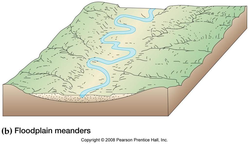
20 Stream Channel Patterns (4 types) Sinuous Channels Common Gentle winding channels Found in both steep and gentle gradients But the flatter the land, the more sinuous a stream becomes; eventually, it becomes a meander.
. Also forms abandoned channels. E.g.")
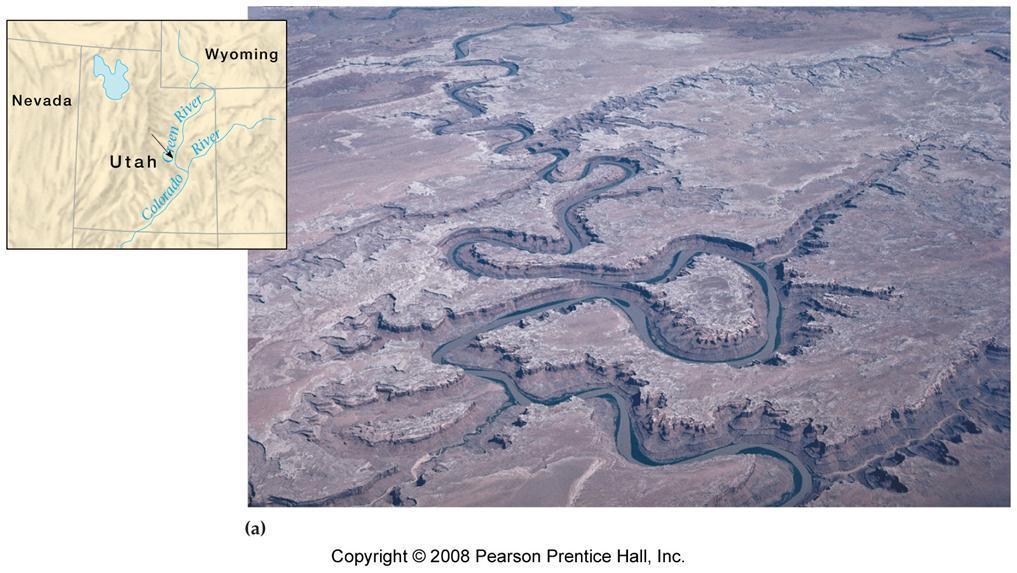
21 Stream Channel Patterns (4 types) Meandering Channels Occurs where land is flat, such as large floodplains Tightly curved loops, very serpentine (see picture of River Missouri). Also forms abandoned channels. E.g. Oxbow lakes, like Carter Lake in Omaha.
 the")
22 Stream Channel Patterns (4 types) Braided Channels Heavily loaded stream Gentle gradient slows flow speed Slow moving stream chokes channel with alluvium Sand and gravel bar deposits divide (braid) the stream
. But in this case, underlying structure does not control the pattern, since it s found in almost flat land")
23 Stream Drainage Patterns Dendritic Drainage Pattern Most common drainage pattern Tree-like, angles less than 90 degrees (see figure). But in this case, underlying structure does not control the pattern, since it s found in almost flat land

24 Stream Drainage Patterns Trellis Drainage Pattern Caused by alternating bands of tilted hard and soft rocks Long parallel streams cut into soft rocks Parallel streams are jointed by short, rightangled segments.

25 Stream Drainage Patterns

26 Stream Drainage Patterns Radial Drainage Pattern Streams drain from a mountain peak or volcano

27 Stream Drainage Patterns Centripetal Drainage Pattern Here, streams converge into a basin (opposite of radial pattern, where they radiate away )
.")
28 Stream Drainage Patterns Annular Drainage Pattern Streams converge into a basin, in right angles between hard and soft rock (almost sounds like the trellis pattern at first, but these branches here all converge at once).

29 The Shaping and Reshaping of Valleys Valley Deepening Downcutting and V- shaped Valleys Usually by streams with rapid speed or large volume Base level is the lower limit of down-cutting that a stream can do.
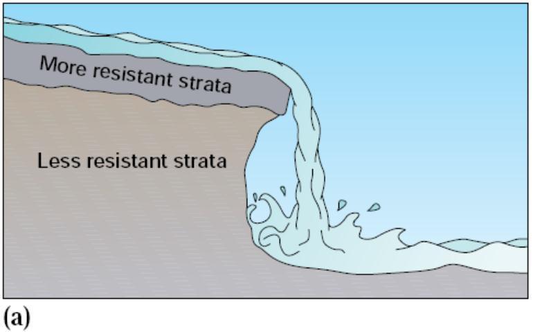
30 Knickpoint Migration
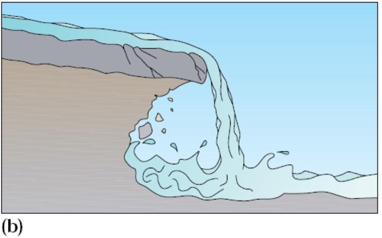
31 Knickpoint Migration
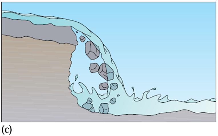
32 Knickpoint Migration
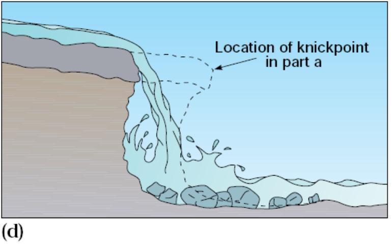
33 Knickpoint Migration
")
34 Niagara Falls (Knickpoint) Retreat
, and slowest on the inside (where it")
35 Valley Widening Lateral (side) erosion by a meandering stream. i.e., side-toside erosion. Water moves fastest on the outside of a curve (where it erodes), and slowest on the inside (where it deposits alluvium).

36 Valley Widening

37 Valley Widening

38 Valley Widening

39 Valley Lengthening Headward erosion: when the valley lengthens backwards at the expense of the interfluve (land above the valley
")
40 Headward (gully) erosion

41 Valley Lengthening Leading to stream capture or stream piracy
42 Stream capture

43 Stream capture

44 Stream capture
45 Delta Formation River mouth deposits leads to lengthening of stream valley, downstream. Some rivers do not have deltas because the ocean currents are so strong that the sediments are just swept away.

46 Delta Formation

47 Locations of the world s largest deltas
48 Largest Deltas and Largest Deltaless Rivers
49 Largest Deltas and Largest Deltaless Rivers

50 Floodplains Floodplain Landforms Floodplain low-lying, flat alluvial valley floor Very prone to flooding; buildings prohibited by FEMA
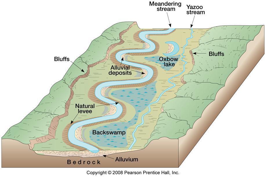
51 Floodplain Landforms
52 Landform Formation
53 Landform Formation

54 Landform Formation
55 Landform Formation

56 Natural levee

57 Stream Rejuvenation Tectonic Uplift Increased gradient Dramatic downcutting Landforms Stream Terraces Entrenched Meanders

58 Stream Rejuvenation Tectonic Uplift Increased gradient Dramatic downcutting Landforms Stream Terraces Entrenched Meanders

59 Stream Rejuvenation Tectonic Uplift Increased gradient Dramatic downcutting Landforms Stream Terraces Entrenched Meanders
60 Entrenched Meanders
61 Meander Entrenchment
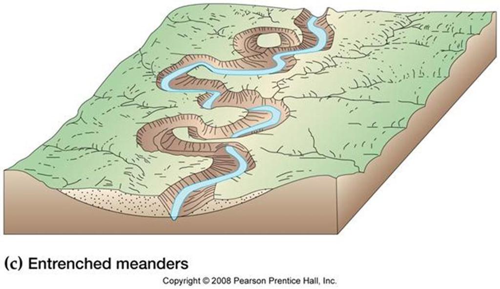
62 Meander Entrenchment
63 Theories of Landform Development Davis Geomorphic Cycle Model Assumptions Stages Youth Maturity Old Age Rejuvenation
64 Theories of Landform Development Davis Geomorphic Cycle Model Assumptions Stages Youth Maturity Old Age Rejuvenation
65 Theories of Landform Development Davis Geomorphic Cycle Model Assumptions Stages Youth Maturity Old Age Rejuvenation

66 Theories of Landform Development Davis Geomorphic Cycle Model Assumptions Stages Youth Maturity Old Age Rejuvenation
Streams. Water. Hydrologic Cycle. Geol 104: Streams
 Streams Why study streams? Running water is the most important geologic agent in erosion, transportation and deposition of sediments. Water The unique physical and chemical properties of water make it
ES 105 Surface Processes I. Hydrologic cycle A. Distribution % in oceans 2. >3% surface water a. +99% surface water in glaciers b.
 ES 105 Surface Processes I. Hydrologic cycle A. Distribution 1. +97% in oceans 2. >3% surface water a. +99% surface water in glaciers b. >1/3% liquid, fresh water in streams and lakes~1/10,000 of water
Running Water Earth - Chapter 16 Stan Hatfield Southwestern Illinois College
 Running Water Earth - Chapter 16 Stan Hatfield Southwestern Illinois College Hydrologic Cycle The hydrologic cycle is a summary of the circulation of Earth s water supply. Processes involved in the hydrologic
Erosion Surface Water. moving, transporting, and depositing sediment.
 + Erosion Surface Water moving, transporting, and depositing sediment. + Surface Water 2 Water from rainfall can hit Earth s surface and do a number of things: Slowly soak into the ground: Infiltration
Streams. Stream Water Flow
 CHAPTER 14 OUTLINE Streams: Transport to the Oceans Does not contain complete lecture notes. To be used to help organize lecture notes and home/test studies. Streams Streams are the major geological agents
Running Water: The Geology of Streams and Floods Running Water Chapter 14
 Geology 800 Today Running Water: The Geology of Streams and Floods Running Water Chapter 14 Next Class Oceans and Coasts 15 Stream Flow Streams Ribbons of water that flow down channels. Runoff Water in
Final Exam. Running Water Erosion and Deposition. Willamette Discharge. Running Water
 Final Exam Running Water Erosion and Deposition Earth Science Chapter 5 Pages 120-135 Scheduled for 8 AM, March 21, 2006 Bring A scantron form A calculator Your 3 x 5 paper card of formulas Review questions
11/12/2014. Running Water. Introduction. Water on Earth. The Hydrologic Cycle. Fluid Flow
 Introduction Mercury, Venus, Earth and Mars share a similar history, but Earth is the only terrestrial planet with abundant water! Mercury is too small and hot Venus has a runaway green house effect so
Landscape Development
 Landscape Development Slopes Dominate Natural Landscapes Created by the interplay of tectonic and igneous activity and gradation Deformation and uplift Volcanic activity Agents of gradation Mass wasting
Chapter 10. Running Water aka Rivers. BFRB Pages
 Chapter 10 Running Water aka Rivers BFRB Pages 101-116 Stream Erosion and Transportation Running water is all precipitation (rain, snow, etc) that falls on Earth and is pulled downhill by gravity. Running
STUDY GUIDE FOR CONTENT MASTERY. Surface Water Movement
 Surface Water SECTION 9.1 Surface Water Movement In your textbook, read about surface water and the way in which it moves sediment. Complete each statement. 1. An excessive amount of water flowing downslope
Rivers and Landslides
 Rivers and Landslides Path of desire or path of least resistance? Desire Path: A term in landscape architecture used to describe a path that isn t designed but rather is worn casually away by people finding
What do you need for a Marathon?
 What do you need for a Marathon? Water and a snack? What about just a normal day? 1 flush = 3.5 gallons 1 flush = 3.5 gallons 10 minute shower = 20 gal 1 flush = 3.5 gallons 10 minute shower = 20 gal Jeans
Surface Water and Stream Development
 Surface Water and Stream Development Surface Water The moment a raindrop falls to earth it begins its return to the sea. Once water reaches Earth s surface it may evaporate back into the atmosphere, soak
River/Stream Erosion Notes
 Name Date ES per Mr. Williams River/Stream Erosion Notes Erosion: the of weathered material. FACT: Running water moves more sediment than ANY other type of erosion. 1. The Water Cycle What happens when
Chapter 12: River Systems and Landforms
 Chapter 12: River Systems and Landforms Base Levels: Local and Ultimate Figure 12.6 Figure 12.2 A Drainage Basin Rills and Gullies feeding into small Streams in Iowa North American Drainage Basins Figure
Chapter 11. Rivers: Shaping our landscape
 Chapter 11 Rivers: Shaping our landscape Learning outcomes In this presentation you will learn: Common terms associated with rivers About the three stages of a river About the processes of river erosion
STREAM SYSTEMS and FLOODS
 STREAM SYSTEMS and FLOODS The Hydrologic Cycle Precipitation Evaporation Infiltration Runoff Transpiration Earth s Water and the Hydrologic Cycle The Hydrologic Cycle The Hydrologic Cycle Oceans not filling
Precipitation Evaporation Infiltration Earth s Water and the Hydrologic Cycle. Runoff Transpiration
 STREAM SYSTEMS and FLOODS The Hydrologic Cycle Precipitation Evaporation Infiltration Earth s Water and the Hydrologic Cycle Runoff Transpiration The Hydrologic Cycle The Hydrologic Cycle Oceans not filling
RIVERS, GROUNDWATER, AND GLACIERS
 RIVERS, GROUNDWATER, AND GLACIERS Delta A fan-shaped deposit that forms when a river flows into a quiet or large body of water, such as a lake, an ocean, or an inland sea. Alluvial Fan A sloping triangle
Year 6. Geography. Revision
 Year 6 Geography Revision November 2017 Rivers and World knowledge How the water cycle works and the meaning of the terms evaporation, condensation, precipitation, transpiration, surface run-off, groundwater
Water Erosion (pages )
") Water Erosion (pages 272 281) Runoff and Erosion (pages 273 274) Key Concept: Moving water is the major agent of the erosion that has shaped Earth s land surface. Falling raindrops can loosen and pick
Water Erosion (pages 272 281) Runoff and Erosion (pages 273 274) Key Concept: Moving water is the major agent of the erosion that has shaped Earth s land surface. Falling raindrops can loosen and pick
FLUVIAL PROCESSES 13 MARCH 2014
 FLUVIAL PROCESSES 13 MARCH 2014 In this lesson we: Lesson Description Look at river profiles, river grading, river rejuvenation as well as the identification, description and formation of fluvial landforms.
Changing Earth s Surface
 Name Date Class Changing Earth s Surface What processes wear down and build up Earth s surface? What causes the different types of mass movement? Erosion is the process by which natural forces move weathered
27. Running Water I (p ; )
") 27. Running Water I (p. 424-436; 440-444) Hydrosphere How much of the Earth s surface is covered by water? Earth's water is collectively called the and is stored in a number of so-called as follows: 1.
27. Running Water I (p. 424-436; 440-444) Hydrosphere How much of the Earth s surface is covered by water? Earth's water is collectively called the and is stored in a number of so-called as follows: 1.
Laboratory Exercise #3 The Hydrologic Cycle and Running Water Processes
 Laboratory Exercise #3 The Hydrologic Cycle and Running Water Processes page - 1 Section A - The Hydrologic Cycle Figure 1 illustrates the hydrologic cycle which quantifies how water is cycled throughout
NATURAL RIVER. Karima Attia Nile Research Institute
 NATURAL RIVER CHARACTERISTICS Karima Attia Nile Research Institute NATURAL RIVER DEFINITION NATURAL RIVER DEFINITION Is natural stream of water that flows in channels with ih more or less defined banks.
What is weathering and how does it change Earth s surface? Answer the question using
 7 th Grade Lesson What is weathering and how does it change Earth s surface? Answer the question using the sentence frame. You have 4 minutes. Weathering is. This changes the Earth s surface because. 1
1. Any process that causes rock to crack or break into pieces is called physical weathering. Initial product = final product
 Weathering 1. Any process that causes rock to crack or break into pieces is called physical weathering. Initial product = final product End Result of physical weathering is increased surface area. 2. Physical
WATER ON AND UNDER GROUND. Objectives. The Hydrologic Cycle
 WATER ON AND UNDER GROUND Objectives Define and describe the hydrologic cycle. Identify the basic characteristics of streams. Define drainage basin. Describe how floods occur and what factors may make
Lecture Outlines PowerPoint. Chapter 5 Earth Science 11e Tarbuck/Lutgens
 Lecture Outlines PowerPoint Chapter 5 Earth Science 11e Tarbuck/Lutgens 2006 Pearson Prentice Hall This work is protected by United States copyright laws and is provided solely for the use of instructors
Erosion and Deposition
 Erosion and Deposition Erosion Sediment natural forces move rock/soil from one place to another. gravity, water, wind, glaciers, waves are causes material moved by erosion Deposition when erosion lays
REVIEW. There are 2 types of WEATHERING: 1. CHEMICAL 2. PHYSICAL. What is WEATHERING? The breakdown of rocks at or near Earth s surface
 REVIEW What is WEATHERING? Def: The breakdown of rocks at or near Earth s surface There are 2 types of WEATHERING: 1. CHEMICAL 2. PHYSICAL CHEMICAL WEATHERING EXAMPLES: 1. OXIDATION (rust) CHEMICAL WEATHERING
6.1 Water. The Water Cycle
 6.1 Water The Water Cycle Water constantly moves among the oceans, the atmosphere, the solid Earth, and the biosphere. This unending circulation of Earth s water supply is the water cycle. The Water Cycle
What are the different ways rocks can be weathered?
 Romano - 223 What are the different ways rocks can be weathered? Weathering - the breakdown of rocks and minerals at the Earth s surface 1. 2. PHYSICAL WEATHERING Rock is broken into smaller pieces with
Prentice Hall EARTH SCIENCE
 Prentice Hall EARTH SCIENCE Tarbuck Lutgens Running Water and Groundwater Running Water The Water Cycle Water constantly moves among the oceans, the atmosphere, the solid Earth, and the biosphere. This
mountain rivers fixed channel boundaries (bedrock banks and bed) high transport capacity low storage input output
 high transport capacity low storage input output") mountain rivers fixed channel boundaries (bedrock banks and bed) high transport capacity low storage input output strong interaction between streams & hillslopes Sediment Budgets for Mountain Rivers Little
mountain rivers fixed channel boundaries (bedrock banks and bed) high transport capacity low storage input output strong interaction between streams & hillslopes Sediment Budgets for Mountain Rivers Little
Earth Science Chapter 6 Section 2 Review
 Name: Class: Date: Earth Science Chapter 6 Section Review Multiple Choice Identify the choice that best completes the statement or answers the question. 1. Most streams carry the largest part of their
River Systems. Physical Geography Lecture - GEOG B1. Accessible on:
 River Systems Physical Geography Lecture - GEOG B1 Accessible on: www.cherylnail.com Hydrology Hydrology is the scientific study of the movement, distribution, and properties of water on Earth (and other
Weathering, Erosion, Deposition, and Landscape Development
 Weathering, Erosion, Deposition, and Landscape Development I. Weathering - the breakdown of rocks into smaller particles, also called sediments, by natural processes. Weathering is further divided into
Chapter 2. Wearing Down Landforms: Rivers and Ice. Physical Weathering
 Chapter 2 Wearing Down Landforms: Rivers and Ice Physical Weathering Weathering vs. Erosion Weathering is the breakdown of rock and minerals. Erosion is a two fold process that starts with 1) breakdown
Environmental Geology Chapter 9 Rivers and Flooding
 Environmental Geology Chapter 9 Rivers and Flooding Flooding in Pakistan 2010-1600 killed/20000 affected The hydrologic cycle is powered by the Sun The cycle includes evaporation, precipitation, infiltration,
1. The map below shows a meandering river. A A' is the location of a cross section. The arrows show the direction of the river flow.
 1. The map below shows a meandering river. A A' is the location of a cross section. The arrows show the direction of the river flow. Which cross section best represents the shape of the river bottom at
Fresh Water: Streams, Lakes Groundwater & Wetlands
 Fresh Water:, Lakes Groundwater & Wetlands Oct 27 Glaciers and Ice Ages Chp 13 Nov 3 Deserts and Wind and EXAM #3 Slope hydrologic cycle P = precip I = precip intercepted by veg ET = evapotranspiration
Topic 6: Weathering, Erosion and Erosional-Deposition Systems (workbook p ) Workbook Chapter 4, 5 WEATHERING
 Workbook Chapter 4, 5 WEATHERING") Topic 6: Weathering, Erosion and Erosional-Deposition Systems (workbook p. 95-125) Workbook Chapter 4, 5 THE BIG PICTURE: Weathering, erosion and deposition are processes that cause changes to rock material
Topic 6: Weathering, Erosion and Erosional-Deposition Systems (workbook p. 95-125) Workbook Chapter 4, 5 THE BIG PICTURE: Weathering, erosion and deposition are processes that cause changes to rock material
EROSION AND DEPOSITION
 CHAPTER 8 EROSION AND DEPOSITION SECTION 8 1 Changing Earth s Surface (pages 252-255) This section explains how sediment is carried away and deposited elsewhere to wear down and build up Earth s surface.
Chapter 3 Erosion and Deposition. The Big Question:
 Chapter 3 Erosion and Deposition The Big Question: 1 Design a way to represent and describe the 4 types of mass movement. You may use pictures, diagrams, list, web, chart, etc 2 Chapter 3: Erosion and
Earth Science Chapter 9. Day 6 - Finish Capillary Action Lab - Quiz over Notes - Review Worksheets over Sections 9.2 and 9.3
 Earth Science Chapter 9 Day 1 Day 2 Day 3 Read Section 9.1 Surface Water Chapter 9 Term Sheet Notes over Section 9.1 Surface Water Section 9.1 Review Worksheets Quiz over Section 9.1 Notes Virtual Lab
The Hydrologic Cycle STREAM SYSTEMS. Earth s Water and the Hydrologic Cycle. The Hydrologic Cycle. Hydrologic Cycle
 STREAM SYSTEMS Earth Science: Chapter 5 Reading pages 114-124 The Hydrologic Cycle Oceans not filling up Evaporation = precipitation System is balanced Earth s Water and the Hydrologic Cycle Earth s Water
GEOL 1121 Earth Processes and Environments
 GEOL 1121 Earth Processes and Environments Wondwosen Seyoum Department of Geology University of Georgia e-mail: seyoum@uga.edu G/G Bldg., Rm. No. 122 Seyoum, 2015 Chapter 6 Streams and Flooding Seyoum,
10/27/2014. Surface Processes. Surface Processes. Surface Processes. Surface Processes. Surface Processes
 Hewitt/Lyons/Suchocki/Yeh Conceptual Integrated Science Chapter 25 Surface or surficial processes originate at Earth's surface and reshape its contours. Surface processes include: Weathering Erosion Deposition
Chapter 2. Denudation: Rivers and Ice
 Chapter 2. Denudation: Rivers and Ice DENUDATION: process that lowers level of land - caused by rivers, glaciers, waves & wind - involves processes of WEATHERING & EROSION Weathering Def: breakdown of
Summary. Streams and Drainage Systems
 Streams and Drainage Systems Summary Streams are part of the hydrologic cycle and the chief means by which water returns from the land to the sea. They help shape the Earth s surface and transport sediment
Aquifer an underground zone or layer of sand, gravel, or porous rock that is saturated with water.
 Aggradation raising of the streambed by deposition that occurs when the energy of the water flowing through a stream reach is insufficient to transport sediment conveyed from upstream. Alluvium a general
Geog Lecture 19
 Geog 1000 - Lecture 19 Fluvial Geomorphology and River Systems http://scholar.ulethbridge.ca/chasmer/classes/ Today s Lecture (Pgs 346 355) 1. What is Fluvial Geomorphology? 2. Hydrology and the Water
Lectures Hydrology & Fluvial Geomorphology. Gauley River Images. Ancients' (= Biblical) Model of Water (Hydrologic) Cycle
 Model of Water (Hydrologic) Cycle") Lectures 11-13 13 Hydrology & Fluvial Geomorphology Gauley River Images http://www.youtube.com/watch?v=eulmuyegtz4&feature=related Ancients' (= Biblical) Model of Water (Hydrologic) Cycle Stream Water
Lectures 11-13 13 Hydrology & Fluvial Geomorphology Gauley River Images http://www.youtube.com/watch?v=eulmuyegtz4&feature=related Ancients' (= Biblical) Model of Water (Hydrologic) Cycle Stream Water
Science EOG Review: Landforms
 Mathematician Science EOG Review: Landforms Vocabulary Definition Term canyon deep, large, V- shaped valley formed by a river over millions of years of erosion; sometimes called gorges (example: Linville
True or False: The Earth s surface has stayed the same for thousands of years
 True or False: The Earth s surface has stayed the same for thousands of years True or False: The Earth s surface has stayed the same for thousands of years The Earth s surface is always changing! Weathering
Erosion and Deposition
 CHAPTER 3 LESSON 2 Erosion and Deposition Landforms Shaped by Water and Wind Key Concepts What are the stages of stream development? How do water erosion and deposition change Earth s surface? How do wind
CE/SC : Planet Earth. Streams and Floods. Earth. Portrait of a Planet Fifth Edition. Chapter 17. Stream Runoff Draining the Land
 CE/SC 10110-20110: Planet Earth Streams and Floods Earth Portrait of a Planet Fifth Edition Chapter 17 Stream Runoff Draining the Land 2 Hydrologic Cycle 3 Rivers & Streams: Basics River = big stream!
Rivers. Regents Earth Science Weathering & Erosion
 Regents Earth Science Weathering & Erosion Name: Rivers Use your notes, the handout Weathering and Erosion and your review book to answer the following questions on Rivers. Be sure to read the information
FLUVIAL LANDFORMS. Floodplains
 FLUVIAL LANDFORMS Floodplains fairly flat & continuous surface occupying much of a valley bottom normally underlain by unconsolidated sediments subject to periodic flooding (usually once every year or
River Processes. A) Write definitions for the terms erosion, transportation & deposition.
 Write definitions for the terms erosion, transportation & deposition.") River Processes Lesson Aims To learn what is erosion, transportation and deposition. To learn which processes carry out erosion, transportation and deposition in river systems. Within rivers a number of
River Processes Lesson Aims To learn what is erosion, transportation and deposition. To learn which processes carry out erosion, transportation and deposition in river systems. Within rivers a number of
Fluvial Systems Lab Environmental Geology Lab Dr. Johnson
 Fluvial Systems Lab Environmental Geology Lab Dr. Johnson *Introductory sections of this lab were adapted from Pidwirny, M. (2006). "Streamflow and Fluvial Processes". Fundamentals of Physical Geography,
The origin of Rivers Erosion:
 The origin of Rivers Erosion: is the action of surface processes (such as water flow or wind) that removes soil, rock, or dissolved material from one location on the Earth's crust, and then transport it
1. The diagram below shows the stump of a tree whose root grew into a small crack in bedrock and split the rock apart.
 1. The diagram below shows the stump of a tree whose root grew into a small crack in bedrock and split the rock apart. 4. Which process involves either a physical or chemical breakdown of earth materials?
Riparian Assessment. Steps in the right direction... Drainage Basin/Watershed: Start by Thinking Big. Riparian Assessment vs.
 Riparian Assessment vs. Monitoring Riparian Assessment What is a healthy stream? Determine stream/riparian health Determine change or trend, especially in response to mgmt Classification = designation
Bell Ringer. Are soil and dirt the same material? In your explanation be sure to talk about plants.
 Bell Ringer Are soil and dirt the same material? In your explanation be sure to talk about plants. 5.3 Mass Movements Triggers of Mass Movements The transfer of rock and soil downslope due to gravity is
GEOL 407- Geomorphology Fall '10
 1. Definitions- define any 8 of the following (3 pts each) A. Karst- A term derived from the type section area of the former Yugoslavia which describes a landscape created by dissolution of the underlying
In the space provided, write the letter of the description that best matches the term or phrase. a. any form of water that falls to Earth s
 Skills Worksheet Concept Review In the space provided, write the letter of the description that best matches the term or phrase. 1. condensation 2. floodplain 3. watershed 4. tributary 5. evapotranspiration
EROSION, DEPOSITION AND SEDIMENTARY ROCKS. Reading: Earth Science Tarbuck and Lutgens Chapter 5: pages Chapter 3: pages 52-54, 61-69
 EROSION, DEPOSITION AND SEDIMENTARY ROCKS Reading: Earth Science Tarbuck and Lutgens Chapter 5: pages 124-133 Chapter 3: pages 52-54, 61-69 Base Level Resistant bed Resistant bed creates a local base level
1/6/ th Grade Earth s Surface. Chapter 3: Erosion and Deposition. Lesson 1 (Mass Movement)
") Lesson 1 (Mass Movement) 7 th Grade Earth s Surface Chapter 3: Erosion and Deposition Weathering the chemical and physical processes that break down rock at Earth s surface Mechanical weathering when rock
Lesson 1 (Mass Movement) 7 th Grade Earth s Surface Chapter 3: Erosion and Deposition Weathering the chemical and physical processes that break down rock at Earth s surface Mechanical weathering when rock
Surface Water Short Study Guide
 Name: Class: Date: Surface Water Short Study Guide Multiple Choice Identify the letter of the choice that best completes the statement or answers the question. 1. The three ways in which a stream carries
EXTERNAL LAND FORMING PROCESSES
 NAME SCHOOL INDEX NUMBER DATE EXTERNAL LAND FORMING PROCESSES WEATHERING 1 1998 Q 7 (a) (i) What is the difference between weathering and mass wasting (ii) List five processes involved in chemical weathering
Landforms. Why does the land look like it does? 1. Controlled by water 2. Controlled by the rocks
 Landforms Why does the land look like it does? 1. Controlled by water 2. Controlled by the rocks Landforms Made by Running Water Stream erosion The evolution of a river system Entrenched meanders Fluvial
Rivers T. Perron
 1 Rivers T. Perron 12.001 After our discussions of large-scale topography, how we represent topography in maps, and how topography interacts with geologic structures, you should be frothing at the mouth
Discharge = Velocity x Cross-sectional area
 Name ENVI.2030L - Surface and Groundwater I. Introduction In this exercise we will investigate various features associated with streams and ground water. We will make extensive use of topographic maps
4. The map below shows a meandering stream. Points A, B, C, and D represent locations along the stream bottom.
 1. Sediment is deposited as a river enters a lake because the A) velocity of the river decreases B) force of gravity decreases C) volume of water increases D) slope of the river increases 2. Which diagram
SURFACE WATER. Thompson Higher Education 2007; Monroe, Wicander, and Hazlett, Physical Geology en.wikipedia.org
 SURFACE WATER Thompson Higher Education 2007; Monroe, Wicander, and Hazlett, Physical Geology www.google.com en.wikipedia.org KATRINA April 29, 2005 KATRINA April 29, 2005 Golden Canyon, Death Valley,
Mountain Rivers. Gutta cavat lapidem. (Dripping water hollows out a stone) -Ovid, Epistulae Ex Ponto, Book 3, no. 10, 1. 5
 -Ovid, Epistulae Ex Ponto, Book 3, no. 10, 1. 5") Mountain Rivers Gutta cavat lapidem (Dripping water hollows out a stone) -Ovid, Epistulae Ex Ponto, Book 3, no. 10, 1. 5 Mountain Rivers Fixed channel boundaries (bedrock banks and bed) High transport
Mountain Rivers Gutta cavat lapidem (Dripping water hollows out a stone) -Ovid, Epistulae Ex Ponto, Book 3, no. 10, 1. 5 Mountain Rivers Fixed channel boundaries (bedrock banks and bed) High transport
Rivers and Streams. Streams. Hydrologic Cycle. Drainage Basins and Divides. Colorado River Drainage Basin. Colorado Drainage Basins.
 Chapter 14 Hydrologic Cycle Rivers and Streams Streams A stream is a body of water that is confined in a channel and moves downhill under the influence of gravity. This definition includes all sizes of
Weathering, Erosion, Deposition
 Weathering, Erosion, Deposition The breakdown of rocks at or near the Earth s Surface. Physical Chemical - The breakdown of rock into smaller pieces without chemical change. - Dominant in moist /cold conditions
Name. 4. The diagram below shows a soil profile formed in an area of granite bedrock. Four different soil horizons, A, B, C, and D, are shown.
 Name 1. In the cross section of the hill shown below, which rock units are probably most resistant to weathering? 4. The diagram below shows a soil profile formed in an area of granite bedrock. Four different
Annotated Bibliography of River Avulsions Pat Dryer Geography 364 5/14/2007
 Annotated Bibliography of River Avulsions Pat Dryer Geography 364 5/14/2007 1 Table of Contents Introduction 2 Annotations I. River avulsions and their deposits 2 II. Channel avulsion on alluvial fans
Day 3 Weathering and Erosion.notebook. October 02, Section 7.2. Erosion and Deposition. Objectives
 Objectives Describe the relationship of gravity to all agents of erosion. Contrast the features left from different types of erosion. Analyze the impact of living and nonliving things on the processes
1. Erosion by Running Water Most powerful cause of erosion
 I. Destructive Forces Notes: Destructive force: a process in which land is destroyed or changed such as weathering and erosion. All landforms are a result of a combination of constructive and destructive
1. Base your answer to the following question on the map below, which shows the generalized bedrock of a part of western New York State.
 1. Base your answer to the following question on the map below, which shows the generalized bedrock of a part of western New York State. 3. The table below describes the deposits that an observer saw while
Geography Notes for Plonk Meeting
 Geography Notes for Plonk Meeting Hydrologic Cycle 1. Rainfall Water falls as rain or snow if the air is cold enough. 2. Groundwater Water that seeps into the ground may be absorbed by plants or flow into
NCM COMPUTER & BUSINESS ACADEMY ASSIGNMENT TERM
 NCM COMPUTER & BUSINESS ACADEMY SUBJECT: GEOGRAPHY GRADE 12 ASSIGNMENT TERM 1-2016 TOTAL: 150 MARKS LECTURER: ANSWER ALL QUESTIONS CLIMATE, WEATHER AND GEOMORPHOLOGY Answer at least ONE question in this
Erosional and depositional landforms formed by the action of water
 Erosional and depositional landforms formed by the action of water In the previous articles, we were discussing various types of endogenic and exogenic processes. We have also seen that erosion and deposition
The Active River. Rivers: Agents of Erosion. Key Concept Water running downhill is the dominant process in shaping the landscape.
 1 What You Will Learn Moving water shapes the surface of Earth by the process of erosion. The sun is the major source of energy that drives the water cycle. Three factors that affect the rate of stream
Page 1. Name:
 Name: 1) Which event is the best example of erosion? dissolving of rock particles on a limestone gravestone by acid rain breaking apart of shale as a result of water freezing in a crack rolling of a pebble
Class Notes: Surface Processes
 Name: Date: Period: Surface Processes The Physical Setting: Earth Science Class Notes: Surface Processes I. Weathering and Soils Weathering -! Sediments -! Weathering occurs when rocks are exposed to:
Section 5. Low-Gradient Streams. What Do You See? Think About It. Investigate. Learning Outcomes
 Chapter 4 Surface Processes Section 5 Low-Gradient Streams What Do You See? Learning Outcomes In this section, you will Use models and real-time streamflow data to understand the characteristics of lowgradient
Stream Geomorphology. Leslie A. Morrissey UVM July 25, 2012
 Stream Geomorphology Leslie A. Morrissey UVM July 25, 2012 What Functions do Healthy Streams Provide? Flood mitigation Water supply Water quality Sediment storage and transport Habitat Recreation Transportation
core mantle crust the center of the Earth the middle layer of the Earth made up of molten (melted) rock
 rock") core the center of the Earth mantle the middle layer of the Earth made up of molten (melted) rock crust the surface layer of the Earth that includes the continents and oceans 1 continental drift the theory
core the center of the Earth mantle the middle layer of the Earth made up of molten (melted) rock crust the surface layer of the Earth that includes the continents and oceans 1 continental drift the theory
HW #2 Landscape Travel from A to B 12,
 HW #2 Landscape 2016 Section: Name: ate: 1. ase your answer(s) to the following question(s) on the map below, which represents two bridges that cross the Green River. Letters,, and represent locations
Weathering & Erosion
 Weathering & Erosion Weathering and Erosion Weathering - processes at or near Earth s surface that cause rocks and minerals to break down Erosion - process of removing Earth materials from their original
Surface Events & Landforms. Mrs. Green
 Surface Events & Landforms Mrs. Green Bell Work 1) Which event MOST likely causes the slowest change to the surface of Earth? a) Earthquake b) Landslide c) Volcano d) Wind 2) When cold weather freezes
Essential Questions. What is erosion? What is mass wasting?
 Erosion Essential Questions What is erosion? What is mass wasting? What is Erosion? Erosion The transportation of sediment from one area to another Caused mainly by running water but also caused by glaciers,