River Systems. Physical Geography Lecture - GEOG B1. Accessible on:
|
|
|
- Claire Powell
- 5 years ago
- Views:
Transcription
1 River Systems Physical Geography Lecture - GEOG B1 Accessible on:
2 Hydrology Hydrology is the scientific study of the movement, distribution, and properties of water on Earth (and other planets), including the water cycle, water resources and environmental watershed sustainability. The focus is on water at or below Earth s surface.
3 Fluvial Fluvial - processes associated with rivers and streams and the deposits and landforms created by them. The term river is usually applied to the trunk, or main stream of a network of tributaries Stream is a more general term for water flowing in a channel. When the stream or rivers are associated with glaciers, ice sheets, or ice caps, the term glaciofluvial or fluvioglacial is used.
4 Drainage basin A drainage basin is any area of land where precipitation collects and drains off in streams and comes together to form river systems to a common outlet, such as into a river, bay, or other body of water. Fig Amazon River Drainage Basin and mouth A drainage basin is usually an open system with inputs of precipitation and regional geology. The drainage basin includes all the surface water from rain runoff, snowmelt, and nearby streams that run downslope towards the shared outlet, as well as the groundwater underneath the earth's surface. Drainage basins raange in size from tiny to vast

5 Mississippi River Drainage Basin Appalachian Mountains to the east and Rockies to the west 5
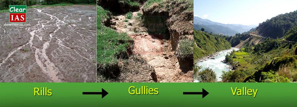
6 Drainage Sheetflow - an overland flow or downslope movement of water taking the form of a thin, continuous film over relatively smooth soil or rock surfaces. Drainage can also concentrate in rills, small scale grooves in the landscape. Rills can combine to form gullies, and then stream channels leading to a valley floor.
7 7
8 Drainage Divide The high ground that separates two drainage basins is a drainage divide. Fig A continental divide is a drainage divide on a continent such that the drainage basin on one side of the divide feeds into one ocean or sea, and the basin on the other side either feeds into a different ocean or sea. * *Or else is internal, or endorheic, not connected to the open sea 8


9 Where a continental divide meets an internal, or endorheic basin, such as the Great Divide Basin of Wyoming, the continental divide splits and encircles the basin. 9
10 Internal drainage An endorheic basin is a closed drainage basin that retains water and does not let it flow to other outside bodies of water, such as oceans.* The water leaves the system through evaporation or subsurface gravitational flow. Such a basin may also be referred to as a closed or terminal basin or as an internal drainage system. *The water instead converges instead into lakes or swamps, permanent or seasonal Examples: Utah s Great Salt Lake, Dead Sea region in the Middle East, and the region around the Aral Sea and Caspian Sea in Asia

11 International Drainage Basins Drainage basins don t follow political boundaries. Many basins cover multiple countries (like the Danube River - Fig. 15.4). These rivers many economic functions: commercial transport, municipal water source, agricultural irrigation, fishing, and hydroelectric power. International struggles are under way to save the waters of many drainage basins from industrial waste, sewage, chemical discharges, agricultural runoff, and drainage from ships. 11
12 Drainage density Drainage density is the total length of all the streams and rivers in a drainage basin divided by the total area of the drainage basin.* *It is a measure of how well or how poorly a watershed is drained by stream channels Drainage density depends upon both climate and physical characteristics of the drainage basin. Soil permeability (infiltration difficulty) and underlying rock type affect the runoff in a watershed; impermeable ground or exposed bedrock will lead to an increase in surface water runoff and therefore to more frequent streams. Rugged regions or those with high relief will also have a higher drainage density than other drainage basins if the other characteristics of the basin are the same. 12
13 Drainage pattern Drainage systems can fall into one of several categories known as drainage patterns. Drainage patterns depend on the topography and geology of the land. Dendritic drainage pattern Parallel drainage pattern Trellis drainage pattern Rectangular drainage pattern Radial drainage pattern Deranged drainage pattern Annular drainage pattern


14 Annular Dendritic - most familiar - treelike pattern Trellis - characteristic of dipping or folded topography Radial - results when streams flow off a central peak or dome - like a volcanic mountain Parallel - associated with steep slopes Rectangular - formed by a faulted and jointed landscape - drainage is in a series of right angle turns. Annular - occur on structural domes, with concentric patterns of rock straat guiding stream courses Deranged - no clear geometry to the pattern no true stream valley forms - found in glaciated shield regions of Canada, northern Europe, and some parts of Michigan 14
15 Basic Fluvial Concepts Gradient - the channel slope of a stream * Base Level - the level below which a stream cannot erode its valley ** Discharge - a stream s volume of flow per unit of time Discharge = depth x width x velocity * Defined as the drop in elevation peer unit distance - usually measured in meters per km, or feet per mile. **The ultimate base level is sea level. Regionally a large river or lake is likewise the base level for tributary streams.

16 Hydrograph Hydrograph - shows the changing rate of stream flow (discharge) over time. Fig When rainfall occurs in some part of the watershed, the runoff is concentrated in streams and tributaries in that are. The amount, location, and duration of rainfall determine the peak flow, the highest discharge that occurs during a precipitation event. The nature of the surface in a watershed, whether permeable or impermeable, affects peak flow and the timing of changes recorded in the hydrograph. Which leads us to the flash flood..
17 Flash Flood Flash flood - a sudden and short-lived torrent of water that exceeds the capacity of a stream channel - associated with desert and arid regions * Urban areas produce runoff patterns quite similar to those of deserts due to the sealed surfaces of the city drastically reducing infiltration. Fig b *In deserts, where surfaces have thin, impermeable soils and little vegetation, runoff can be high during rainstorms
18 Fluvial Processes Erosion - the process where water dislodges, dissolves or removes weathered surface material from one location, then transport it away to another location Deposition - the process where weathered material which has been eroded is laid down, or deposited
19 Stream Channel Processes Hydraulic action - a type of erosive work performed by flowing water alone - the motion of water against a rock surface produces mechanical weathering. the ability of moving water (flowing or waves) to dislodge and transport rock particles * Abrasion - the process of rock and sediment debris in a river grinding and carving the streambed - like liquid sandpaper ** *A primary example of hydraulic action is a wave striking a cliff face which compresses the air in cracks of the rocks. This exerts pressure on the surrounding rock which can progressively crack, break, splinter and detach rock particles. This is followed by the decompression of the air as the wave retreats which can occur suddenly with explosive force which additionally weakens the rock. Cracks are gradually widened so each wave compresses more air, increasing the explosive force of its release. **The intensity of abrasion depends on the hardness, concentration, velocity, and mass of the moving particles. Abrasion can also happen with debris carried by wind and glaciers. 19
20 Sediment transport Sediment transport - when stream flow propels sand, pebbles, gravel, and even boulders downstream Fig Sediment transport occurs in natural systems where the particles are clastic rocks (sand, gravel, boulders, etc.), mud, or clay; the fluid is air, water, or ice; and the force of gravity acts to move the particles along the sloping surface on which they are resting. Sediment transport due to fluid motion occurs in rivers, oceans, lakes, seas, and other bodies of water due to currents and tides. Transport is also caused by glaciers as they flow, and on terrestrial surfaces under the influence of wind. 20
21 Dissolved load Dissolved load - material from chemical weathering, that is carried in solution by a stream
22 Suspended Load Suspended load -the portion of a stream s sediment uplifted by the fluid's flow in the process of sediment transportation. It is kept suspended by the stream's turbulence. The suspended load generally consists of smaller particles, like Clay, Silt, and fine sands.
23 Bed load Bed load - consists of the larger sediment which is transported by: traction - process of rolling or dragging sediment materials along the streambed saltation - refers to the way particles may bounce along in short hops and jumps * *from the Latin saltim - which means by leaps or jumps Particles transported by saltation are too large to remain in suspension but are not confined to the sliding and rolling motion of traction.
24 Stream Velocity Stream velocity, or speed, affect its ability to carry sediment. With increased kinetic energy in a stream, parts of the bed load are rafted upward and become part of a suspended load. Example: a flood As a flood flows build, it increases the stream s ability to erode and transport sediment. 24
25 Degradation / Aggradation Degradation - the process when a streambed erodes due to higher stream velocity Aggradation - the process of a stream bed being built up through the deposition of sediment occurs when the velocity of a stream diminishes Fig
26 Effects of Dams on Sediment Transport Dams disrupt natural river discharge and sediment transport - usually with detrimental effects on river systems. river bank beaches disappear fish migration disturbed depleting nutrients pp Focus Study Stream Restoration
27 Channel Patterns Braided streams - consists of a network of small channels separated by small and often temporary islands called braid bars * Fig Meandering streams - a more sinuous (snakelike) form of channel pattern on a gradual slope - it weaves back and forth across the landscape *Created when reduced discharge lowers a stream s transporting ability, such as after flooding. Commonly occur in glacial environments where coarse sediment is plentiful and slopes are steep - like in New Zealand, Alaska, Nepal, and Tibet There are also anabranching channels - when multiple large channels are present across a vast floodplain Fig and occasionally there are straight channels (Fig ), but these aren t as common and depend on the bedrock
28 Meandering Channel Erosion - I * Undercut bank - the outside bank of a bend in a stream, which is continually undergoing erosion due to higher velocity shaped much like a small cliff, and are formed by the erosion of soil as the stream collides with the river bank. Point Bar - an area of sediment deposition on the inside of a meander bend due to lower stream velocity *A meander, in general, is a bend in a sinuous watercourse or river. A meander forms when moving water in a stream erodes the outer banks and widens its valley, and the inner part of the river has less energy and deposits silt. A stream of any volume may assume a meandering course, alternately eroding sediments from the outside of a bend and depositing them on the inside. The result is a snaking pattern as the stream meanders back and forth across its down-valley axis. 28

29 Meandering Channel Erosion - II Cutoff - formed when the river cuts through a narrow neck of a loop in a meander Oxbow lake - a horseshoe shaped body of water that forms when a wide meander from the main stem of a river is cut off, creating a free-standing body of water. * *This landform is so named for its distinctive curved shape, resembling the bow pin of an oxbow. An oxbow lake is known as a billabong in Australia

30 Also see pp GIA 15 Meandering Streams 30
31 Graded stream The tendency of natural systems is to move towards a state of equilibrium.. Graded stream - a stream in which the channel slope has adjusted, given the discharge and channel conditions, so that stream velocity is just enough to transport the sediment load
32 Tectonic Uplift A graded stream can be affected by tectonic uplift that changes the elevation of the stream relative to its base level. The lifting of the landscape would increase the stream gradient, thereby increasing erosional activity - degradation is rejuvenated. Can lead to entrenched meanders - Fig

33 Nickpoint Nickpoint - a part of a river channel where there is a sharp change in channel slope, such as a waterfall or lake. Fig b & 15.22
34 Depositional Landforms Alluvium - the unconsolidated clay, silt, sand, gravel, and mineral fragments deposited by running water When this loose alluvial material is deposited it creates landforms such as bars, floodplains, terraces, and deltas. When this loose alluvial material is deposited or cemented into a lithological unit, or lithified, it is called an alluvial deposit.[3] 34
35 Floodplains Floodplain - a flat, low-lying area adjacent to a river that stretches from the banks of its channel to the base of the enclosing valley walls and experiences recurrent flooding The area is inundated when the river overflows its channel during times of flooding. When the water recedes, it leaves behind alluvial deposits that mask the underlying rock. Flood plains are made by a meander eroding sideways as it travels downstream. When a river breaks its banks and floods, it leaves behind layers of alluvium (silt). These gradually build up to create the floor of the flood plain. Floodplains generally contain unconsolidated sediments, often extending below the bed of the stream. 35
36 Floodplain Focus on alluvial deposits, Yazoo stream tributary, and natural levees.. 36
37 Yazoo Stream / Natural Levee Yazoo stream - flows parallel to the main river in a floodplain, but are blocked from joining it by natural levees Natural levee - a long, low ridge that forms on both sides of a stream in a developed floodplain - a depositional product of river flooding


38 Alluvial Terrace Level areas that appear as topographic steps above a stream, created by a stream as it scours with renewed downcutting into its floodplain
39 Alluvial fan Alluvial fan - a fan- or cone-shaped deposit of fluvial sediment crossed and built up by streams. Typically found in arid and semiarid climates where canyon draining from mountainous terrain emerges out onto a flatter plain. Stream velocity decreases and sediment is deposited over and over again. 39


40 Death Valley San Bernadino Well developed alluvial fans also can be a major source of groundwater. Some cities - San Bernadino, for example - are built on alluvial fans and extract their municipal water supplies from them 40

41 Bajada Bajada - consists of a series of coalescing alluvial fans along a mountain front. This bajada lies on the west side of Death Valley, CA 41


42 Playa Playa - as water evaporates from a temporary shallow lake left in a desert, a salty crust may be left behind on the desert floor A dry lake is either a basin or depression that formerly contained a standing surface water body, which disappeared when evaporation processes exceeded recharge. 42
 another river that cannot transport away the supplied")

43 River Deltas Delta - a landform that forms from deposition of sediment carried by a river as the flow leaves its mouth and enters slower-moving or standing water * *This occurs where a river enters an ocean, sea, estuary, lake, reservoir, or (more rarely) another river that cannot transport away the supplied sediment. A delta is named for its characteristic triangular shape, after the Greek letter delta Each flood deposits a new layer of alluvium over portions of the delta, extending it outward. Fig Ganges and Brahmaputra Rivers combined delta complex largest in the world Fig Mississippi River Delta 43


44 Estuary Estuary - a partially enclosed coastal body of brackish water with one or more fresh-water rivers flowing into it - has a free connection to the open sea. Estuaries form a transition zone between river environments and maritime environments. They are subject both to marine influences such as tides, waves, and the influx of saline water and to riverine influences such as flows of fresh water and sediment. The inflows of both sea water and fresh water provide high levels of nutrients both in the water column and in sediment, making estuaries among the most productive natural habitats in the world. 44

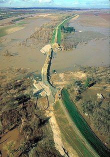
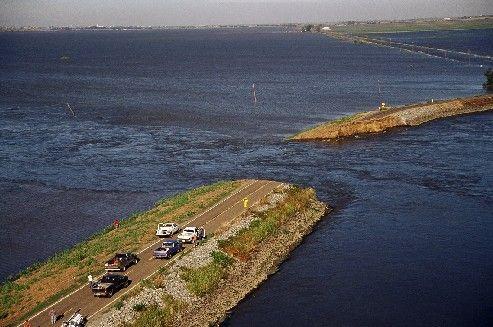
45 Flood Flood - a high water flow that passes over the natural bank along any portion of a stream or river Human Management Flood probability Floodplain management Flooding may occur as an overflow of water from water bodies, such as a river, lake, or ocean, in which the water overtops or breaks levees, resulting in some of that water escaping its usual boundaries,[3] or it may occur due to an accumulation of rainwater on saturated ground in an areal flood. While the size of a lake or other body of water will vary with seasonal changes in precipitation and snow melt, these changes in size are unlikely to be considered significant unless they flood property or drown domestic animals. 45

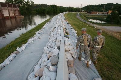
46 Artificial Levee Artificial levees earthen embankments, often built on top of natural levees Fig & & /siteimages/NACCS/07.gif
47 47
Streams. Water. Hydrologic Cycle. Geol 104: Streams
 Streams Why study streams? Running water is the most important geologic agent in erosion, transportation and deposition of sediments. Water The unique physical and chemical properties of water make it
ES 105 Surface Processes I. Hydrologic cycle A. Distribution % in oceans 2. >3% surface water a. +99% surface water in glaciers b.
 ES 105 Surface Processes I. Hydrologic cycle A. Distribution 1. +97% in oceans 2. >3% surface water a. +99% surface water in glaciers b. >1/3% liquid, fresh water in streams and lakes~1/10,000 of water
11/12/2014. Running Water. Introduction. Water on Earth. The Hydrologic Cycle. Fluid Flow
 Introduction Mercury, Venus, Earth and Mars share a similar history, but Earth is the only terrestrial planet with abundant water! Mercury is too small and hot Venus has a runaway green house effect so
Streams. Stream Water Flow
 CHAPTER 14 OUTLINE Streams: Transport to the Oceans Does not contain complete lecture notes. To be used to help organize lecture notes and home/test studies. Streams Streams are the major geological agents
Erosion Surface Water. moving, transporting, and depositing sediment.
 + Erosion Surface Water moving, transporting, and depositing sediment. + Surface Water 2 Water from rainfall can hit Earth s surface and do a number of things: Slowly soak into the ground: Infiltration
Surface Water and Stream Development
 Surface Water and Stream Development Surface Water The moment a raindrop falls to earth it begins its return to the sea. Once water reaches Earth s surface it may evaporate back into the atmosphere, soak
Running Water Earth - Chapter 16 Stan Hatfield Southwestern Illinois College
 Running Water Earth - Chapter 16 Stan Hatfield Southwestern Illinois College Hydrologic Cycle The hydrologic cycle is a summary of the circulation of Earth s water supply. Processes involved in the hydrologic
PHYSICAL GEOGRAPHY. By Brett Lucas
 PHYSICAL GEOGRAPHY By Brett Lucas FLUVIAL PROCESSES Fluvial Processes The Impact of Fluvial Processes on the Landscape Streams and Stream Systems Stream Channels Structural Relationships The Shaping and
STREAM SYSTEMS and FLOODS
 STREAM SYSTEMS and FLOODS The Hydrologic Cycle Precipitation Evaporation Infiltration Runoff Transpiration Earth s Water and the Hydrologic Cycle The Hydrologic Cycle The Hydrologic Cycle Oceans not filling
Precipitation Evaporation Infiltration Earth s Water and the Hydrologic Cycle. Runoff Transpiration
 STREAM SYSTEMS and FLOODS The Hydrologic Cycle Precipitation Evaporation Infiltration Earth s Water and the Hydrologic Cycle Runoff Transpiration The Hydrologic Cycle The Hydrologic Cycle Oceans not filling
Year 6. Geography. Revision
 Year 6 Geography Revision November 2017 Rivers and World knowledge How the water cycle works and the meaning of the terms evaporation, condensation, precipitation, transpiration, surface run-off, groundwater
27. Running Water I (p ; )
") 27. Running Water I (p. 424-436; 440-444) Hydrosphere How much of the Earth s surface is covered by water? Earth's water is collectively called the and is stored in a number of so-called as follows: 1.
27. Running Water I (p. 424-436; 440-444) Hydrosphere How much of the Earth s surface is covered by water? Earth's water is collectively called the and is stored in a number of so-called as follows: 1.
Chapter 10. Running Water aka Rivers. BFRB Pages
 Chapter 10 Running Water aka Rivers BFRB Pages 101-116 Stream Erosion and Transportation Running water is all precipitation (rain, snow, etc) that falls on Earth and is pulled downhill by gravity. Running
RIVERS, GROUNDWATER, AND GLACIERS
 RIVERS, GROUNDWATER, AND GLACIERS Delta A fan-shaped deposit that forms when a river flows into a quiet or large body of water, such as a lake, an ocean, or an inland sea. Alluvial Fan A sloping triangle
What are the different ways rocks can be weathered?
 Romano - 223 What are the different ways rocks can be weathered? Weathering - the breakdown of rocks and minerals at the Earth s surface 1. 2. PHYSICAL WEATHERING Rock is broken into smaller pieces with
FLUVIAL LANDFORMS. Floodplains
 FLUVIAL LANDFORMS Floodplains fairly flat & continuous surface occupying much of a valley bottom normally underlain by unconsolidated sediments subject to periodic flooding (usually once every year or
Landscape Development
 Landscape Development Slopes Dominate Natural Landscapes Created by the interplay of tectonic and igneous activity and gradation Deformation and uplift Volcanic activity Agents of gradation Mass wasting
Final Exam. Running Water Erosion and Deposition. Willamette Discharge. Running Water
 Final Exam Running Water Erosion and Deposition Earth Science Chapter 5 Pages 120-135 Scheduled for 8 AM, March 21, 2006 Bring A scantron form A calculator Your 3 x 5 paper card of formulas Review questions
Fresh Water: Streams, Lakes Groundwater & Wetlands
 Fresh Water:, Lakes Groundwater & Wetlands Oct 27 Glaciers and Ice Ages Chp 13 Nov 3 Deserts and Wind and EXAM #3 Slope hydrologic cycle P = precip I = precip intercepted by veg ET = evapotranspiration
Earth Science Chapter 6 Section 2 Review
 Name: Class: Date: Earth Science Chapter 6 Section Review Multiple Choice Identify the choice that best completes the statement or answers the question. 1. Most streams carry the largest part of their
WATER ON AND UNDER GROUND. Objectives. The Hydrologic Cycle
 WATER ON AND UNDER GROUND Objectives Define and describe the hydrologic cycle. Identify the basic characteristics of streams. Define drainage basin. Describe how floods occur and what factors may make
STUDY GUIDE FOR CONTENT MASTERY. Surface Water Movement
 Surface Water SECTION 9.1 Surface Water Movement In your textbook, read about surface water and the way in which it moves sediment. Complete each statement. 1. An excessive amount of water flowing downslope
Rivers T. Perron
 1 Rivers T. Perron 12.001 After our discussions of large-scale topography, how we represent topography in maps, and how topography interacts with geologic structures, you should be frothing at the mouth
mountain rivers fixed channel boundaries (bedrock banks and bed) high transport capacity low storage input output
 high transport capacity low storage input output") mountain rivers fixed channel boundaries (bedrock banks and bed) high transport capacity low storage input output strong interaction between streams & hillslopes Sediment Budgets for Mountain Rivers Little
mountain rivers fixed channel boundaries (bedrock banks and bed) high transport capacity low storage input output strong interaction between streams & hillslopes Sediment Budgets for Mountain Rivers Little
Laboratory Exercise #3 The Hydrologic Cycle and Running Water Processes
 Laboratory Exercise #3 The Hydrologic Cycle and Running Water Processes page - 1 Section A - The Hydrologic Cycle Figure 1 illustrates the hydrologic cycle which quantifies how water is cycled throughout
What do you need for a Marathon?
 What do you need for a Marathon? Water and a snack? What about just a normal day? 1 flush = 3.5 gallons 1 flush = 3.5 gallons 10 minute shower = 20 gal 1 flush = 3.5 gallons 10 minute shower = 20 gal Jeans
Running Water: The Geology of Streams and Floods Running Water Chapter 14
 Geology 800 Today Running Water: The Geology of Streams and Floods Running Water Chapter 14 Next Class Oceans and Coasts 15 Stream Flow Streams Ribbons of water that flow down channels. Runoff Water in
Rivers and Landslides
 Rivers and Landslides Path of desire or path of least resistance? Desire Path: A term in landscape architecture used to describe a path that isn t designed but rather is worn casually away by people finding
Geography Notes for Plonk Meeting
 Geography Notes for Plonk Meeting Hydrologic Cycle 1. Rainfall Water falls as rain or snow if the air is cold enough. 2. Groundwater Water that seeps into the ground may be absorbed by plants or flow into
GEOL 1121 Earth Processes and Environments
 GEOL 1121 Earth Processes and Environments Wondwosen Seyoum Department of Geology University of Georgia e-mail: seyoum@uga.edu G/G Bldg., Rm. No. 122 Seyoum, 2015 Chapter 6 Streams and Flooding Seyoum,
What is weathering and how does it change Earth s surface? Answer the question using
 7 th Grade Lesson What is weathering and how does it change Earth s surface? Answer the question using the sentence frame. You have 4 minutes. Weathering is. This changes the Earth s surface because. 1
Essential Questions. What is erosion? What is mass wasting?
 Erosion Essential Questions What is erosion? What is mass wasting? What is Erosion? Erosion The transportation of sediment from one area to another Caused mainly by running water but also caused by glaciers,
Aquifer an underground zone or layer of sand, gravel, or porous rock that is saturated with water.
 Aggradation raising of the streambed by deposition that occurs when the energy of the water flowing through a stream reach is insufficient to transport sediment conveyed from upstream. Alluvium a general
1. Erosion by Running Water Most powerful cause of erosion
 I. Destructive Forces Notes: Destructive force: a process in which land is destroyed or changed such as weathering and erosion. All landforms are a result of a combination of constructive and destructive
Science EOG Review: Landforms
 Mathematician Science EOG Review: Landforms Vocabulary Definition Term canyon deep, large, V- shaped valley formed by a river over millions of years of erosion; sometimes called gorges (example: Linville
Chapter 2. Wearing Down Landforms: Rivers and Ice. Physical Weathering
 Chapter 2 Wearing Down Landforms: Rivers and Ice Physical Weathering Weathering vs. Erosion Weathering is the breakdown of rock and minerals. Erosion is a two fold process that starts with 1) breakdown
6.1 Water. The Water Cycle
 6.1 Water The Water Cycle Water constantly moves among the oceans, the atmosphere, the solid Earth, and the biosphere. This unending circulation of Earth s water supply is the water cycle. The Water Cycle
Chapter 11. Rivers: Shaping our landscape
 Chapter 11 Rivers: Shaping our landscape Learning outcomes In this presentation you will learn: Common terms associated with rivers About the three stages of a river About the processes of river erosion
1. Any process that causes rock to crack or break into pieces is called physical weathering. Initial product = final product
 Weathering 1. Any process that causes rock to crack or break into pieces is called physical weathering. Initial product = final product End Result of physical weathering is increased surface area. 2. Physical
Chapter 3 Erosion and Deposition. The Big Question:
 Chapter 3 Erosion and Deposition The Big Question: 1 Design a way to represent and describe the 4 types of mass movement. You may use pictures, diagrams, list, web, chart, etc 2 Chapter 3: Erosion and
Lecture Outlines PowerPoint. Chapter 5 Earth Science 11e Tarbuck/Lutgens
 Lecture Outlines PowerPoint Chapter 5 Earth Science 11e Tarbuck/Lutgens 2006 Pearson Prentice Hall This work is protected by United States copyright laws and is provided solely for the use of instructors
Topic 6: Weathering, Erosion and Erosional-Deposition Systems (workbook p ) Workbook Chapter 4, 5 WEATHERING
 Workbook Chapter 4, 5 WEATHERING") Topic 6: Weathering, Erosion and Erosional-Deposition Systems (workbook p. 95-125) Workbook Chapter 4, 5 THE BIG PICTURE: Weathering, erosion and deposition are processes that cause changes to rock material
Topic 6: Weathering, Erosion and Erosional-Deposition Systems (workbook p. 95-125) Workbook Chapter 4, 5 THE BIG PICTURE: Weathering, erosion and deposition are processes that cause changes to rock material
Name. 4. The diagram below shows a soil profile formed in an area of granite bedrock. Four different soil horizons, A, B, C, and D, are shown.
 Name 1. In the cross section of the hill shown below, which rock units are probably most resistant to weathering? 4. The diagram below shows a soil profile formed in an area of granite bedrock. Four different
The Hydrologic Cycle STREAM SYSTEMS. Earth s Water and the Hydrologic Cycle. The Hydrologic Cycle. Hydrologic Cycle
 STREAM SYSTEMS Earth Science: Chapter 5 Reading pages 114-124 The Hydrologic Cycle Oceans not filling up Evaporation = precipitation System is balanced Earth s Water and the Hydrologic Cycle Earth s Water
Continental Landscapes
 Continental Landscapes Landscape influenced by tectonics, climate & differential weathering Most landforms developed within the last 2 million years System moves toward an equilibrium Continental Landscapes
Weathering, Erosion, Deposition, and Landscape Development
 Weathering, Erosion, Deposition, and Landscape Development I. Weathering - the breakdown of rocks into smaller particles, also called sediments, by natural processes. Weathering is further divided into
Erosion and Deposition
 Erosion and Deposition Erosion Sediment natural forces move rock/soil from one place to another. gravity, water, wind, glaciers, waves are causes material moved by erosion Deposition when erosion lays
EROSION AND DEPOSITION
 CHAPTER 8 EROSION AND DEPOSITION SECTION 8 1 Changing Earth s Surface (pages 252-255) This section explains how sediment is carried away and deposited elsewhere to wear down and build up Earth s surface.
Summary. Streams and Drainage Systems
 Streams and Drainage Systems Summary Streams are part of the hydrologic cycle and the chief means by which water returns from the land to the sea. They help shape the Earth s surface and transport sediment
Prentice Hall EARTH SCIENCE
 Prentice Hall EARTH SCIENCE Tarbuck Lutgens Running Water and Groundwater Running Water The Water Cycle Water constantly moves among the oceans, the atmosphere, the solid Earth, and the biosphere. This
4. The map below shows a meandering stream. Points A, B, C, and D represent locations along the stream bottom.
 1. Sediment is deposited as a river enters a lake because the A) velocity of the river decreases B) force of gravity decreases C) volume of water increases D) slope of the river increases 2. Which diagram
Chapter 12: River Systems and Landforms
 Chapter 12: River Systems and Landforms Base Levels: Local and Ultimate Figure 12.6 Figure 12.2 A Drainage Basin Rills and Gullies feeding into small Streams in Iowa North American Drainage Basins Figure
Geog Lecture 19
 Geog 1000 - Lecture 19 Fluvial Geomorphology and River Systems http://scholar.ulethbridge.ca/chasmer/classes/ Today s Lecture (Pgs 346 355) 1. What is Fluvial Geomorphology? 2. Hydrology and the Water
EARTH S CHANGING SURFACE
 EARTH S CHANGING SURFACE Weathering Together, weathering and erosion work continuously to wear down the material on Earth s surface. weathering process that breaks down rock and other substances of Earth
Surface Water Short Study Guide
 Name: Class: Date: Surface Water Short Study Guide Multiple Choice Identify the letter of the choice that best completes the statement or answers the question. 1. The three ways in which a stream carries
Rivers and Streams. Streams. Hydrologic Cycle. Drainage Basins and Divides. Colorado River Drainage Basin. Colorado Drainage Basins.
 Chapter 14 Hydrologic Cycle Rivers and Streams Streams A stream is a body of water that is confined in a channel and moves downhill under the influence of gravity. This definition includes all sizes of
Rivers. Regents Earth Science Weathering & Erosion
 Regents Earth Science Weathering & Erosion Name: Rivers Use your notes, the handout Weathering and Erosion and your review book to answer the following questions on Rivers. Be sure to read the information
1. The map below shows a meandering river. A A' is the location of a cross section. The arrows show the direction of the river flow.
 1. The map below shows a meandering river. A A' is the location of a cross section. The arrows show the direction of the river flow. Which cross section best represents the shape of the river bottom at
1/6/ th Grade Earth s Surface. Chapter 3: Erosion and Deposition. Lesson 1 (Mass Movement)
") Lesson 1 (Mass Movement) 7 th Grade Earth s Surface Chapter 3: Erosion and Deposition Weathering the chemical and physical processes that break down rock at Earth s surface Mechanical weathering when rock
Lesson 1 (Mass Movement) 7 th Grade Earth s Surface Chapter 3: Erosion and Deposition Weathering the chemical and physical processes that break down rock at Earth s surface Mechanical weathering when rock
Depositional Environment
 Depositional Environment Sedimentary depositional environment describes the combination of physical, chemical and biological processes associated with the deposition of a particular type of sediment. Types
Mountain Rivers. Gutta cavat lapidem. (Dripping water hollows out a stone) -Ovid, Epistulae Ex Ponto, Book 3, no. 10, 1. 5
 -Ovid, Epistulae Ex Ponto, Book 3, no. 10, 1. 5") Mountain Rivers Gutta cavat lapidem (Dripping water hollows out a stone) -Ovid, Epistulae Ex Ponto, Book 3, no. 10, 1. 5 Mountain Rivers Fixed channel boundaries (bedrock banks and bed) High transport
Mountain Rivers Gutta cavat lapidem (Dripping water hollows out a stone) -Ovid, Epistulae Ex Ponto, Book 3, no. 10, 1. 5 Mountain Rivers Fixed channel boundaries (bedrock banks and bed) High transport
3/3/2013. The hydro cycle water returns from the sea. All "toilet to tap." Introduction to Environmental Geology, 5e
 Introduction to Environmental Geology, 5e Running Water: summary in haiku form Edward A. Keller Chapter 9 Rivers and Flooding Lecture Presentation prepared by X. Mara Chen, Salisbury University The hydro
Chapter 2. Denudation: Rivers and Ice
 Chapter 2. Denudation: Rivers and Ice DENUDATION: process that lowers level of land - caused by rivers, glaciers, waves & wind - involves processes of WEATHERING & EROSION Weathering Def: breakdown of
Bell Ringer. Are soil and dirt the same material? In your explanation be sure to talk about plants.
 Bell Ringer Are soil and dirt the same material? In your explanation be sure to talk about plants. 5.3 Mass Movements Triggers of Mass Movements The transfer of rock and soil downslope due to gravity is
NATURAL RIVER. Karima Attia Nile Research Institute
 NATURAL RIVER CHARACTERISTICS Karima Attia Nile Research Institute NATURAL RIVER DEFINITION NATURAL RIVER DEFINITION Is natural stream of water that flows in channels with ih more or less defined banks.
Foundations of Earth Science, 6e Lutgens, Tarbuck, & Tasa
 Foundations of Earth Science, 6e Lutgens, Tarbuck, & Tasa Glacial and Arid Landscapes Foundations, 6e - Chapter 4 Stan Hatfield Southwestern Illinois College Glaciers Glaciers are parts of two basic cycles
Lectures Hydrology & Fluvial Geomorphology. Gauley River Images. Ancients' (= Biblical) Model of Water (Hydrologic) Cycle
 Model of Water (Hydrologic) Cycle") Lectures 11-13 13 Hydrology & Fluvial Geomorphology Gauley River Images http://www.youtube.com/watch?v=eulmuyegtz4&feature=related Ancients' (= Biblical) Model of Water (Hydrologic) Cycle Stream Water
Lectures 11-13 13 Hydrology & Fluvial Geomorphology Gauley River Images http://www.youtube.com/watch?v=eulmuyegtz4&feature=related Ancients' (= Biblical) Model of Water (Hydrologic) Cycle Stream Water
Which map shows the stream drainage pattern that most likely formed on the surface of this volcano? A) B)
 B)") 1. When snow cover on the land melts, the water will most likely become surface runoff if the land surface is A) frozen B) porous C) grass covered D) unconsolidated gravel Base your answers to questions
1. When snow cover on the land melts, the water will most likely become surface runoff if the land surface is A) frozen B) porous C) grass covered D) unconsolidated gravel Base your answers to questions
Changing Earth s Surface
 Name Date Class Changing Earth s Surface What processes wear down and build up Earth s surface? What causes the different types of mass movement? Erosion is the process by which natural forces move weathered
Prentice Hall EARTH SCIENCE
 Prentice Hall EARTH SCIENCE Tarbuck Lutgens Chapter 7 Glaciers, Desert, and Wind 7.1 Glaciers Types of Glaciers A glacier is a thick ice mass that forms above the snowline over hundreds or thousands of
River/Stream Erosion Notes
 Name Date ES per Mr. Williams River/Stream Erosion Notes Erosion: the of weathered material. FACT: Running water moves more sediment than ANY other type of erosion. 1. The Water Cycle What happens when
Laboratory Exercise #4 Geologic Surface Processes in Dry Lands
 Page - 1 Laboratory Exercise #4 Geologic Surface Processes in Dry Lands Section A Overview of Lands with Dry Climates The definition of a dry climate is tied to an understanding of the hydrologic cycle
Environmental Geology Chapter 9 Rivers and Flooding
 Environmental Geology Chapter 9 Rivers and Flooding Flooding in Pakistan 2010-1600 killed/20000 affected The hydrologic cycle is powered by the Sun The cycle includes evaporation, precipitation, infiltration,
What we will cover. The Hydrologic Cycle. River systems. Floods. Groundwater. Caves and Karst Topography. Hot springs
 Fresh Water What we will cover The Hydrologic Cycle River systems Floods Groundwater Caves and Karst Topography Hot springs On a piece of paper, put these reservoirs of water in to order from largest to
 12 10 8 6 4 2 0 40-50 50-60 60-70 70-80 80-90 90-100 Fresh Water What we will cover The Hydrologic Cycle River systems Floods Groundwater Caves and Karst Topography Hot springs Distribution of water in
Weathering, Erosion and Deposition
 Weathering, Erosion and Deposition Shaping the Earth s Surface Weathering the process of breaking down rocks into smaller fragments Erosion the transport of rock fragments from one location to another
Unit 4: Landscapes Practice Problems
 Name: Date: 1. Soil with the greatest porosity has particles that are A. poorly sorted and densely packed B. poorly sorted and loosely packed C. well sorted and densely packed D. well sorted and loosely
Unit 3 Review - Surface Processes
 Unit 3 Review - Surface Processes 1. Why is the surface of Mercury covered with meteor impact craters, while Earth s surface has relatively few craters? A) Mercury is larger than Earth, so it gets hit
CHAPTER 4 NOTES -WEATHERING AND EROSION- LESSON 4.1: TYPES OF WEATHERING
 CHAPTER 4 NOTES -WEATHERING AND EROSION- LESSON 4.1: TYPES OF WEATHERING WEATHERING Weathering- the process by which rocks are broken down by the forces of nature. - the breakdown of large rocks into fragments
Running Water and the Development of Landforms
 Geography IGCSE Module One: River Environments Lesson Thirteen Running Water and the Development of Landforms Aims The aim of this lesson is for you to learn about: processes including o weathering and
Read Across America. Listen as I read for facts about Volcanoes. In the Shadow of the Volcano
 Read Across America Listen as I read for facts about Volcanoes. In the Shadow of the Volcano Constructive & Destructive Processes Earth s surface is always changing. Blowing wind and flowing water causes
Chapter 5: Glaciers and Deserts
 I. Glaciers and Glaciation Chapter 5: Glaciers and Deserts A. A thick mass of ice that forms over land from the compaction and recrystallization of snow and shows evidence of past or present flow B. Types
Name: Class: Date: Multiple Choice Identify the letter of the choice that best completes the statement or answers the question.
 Name: Class: Date: geology ch 7 test 2008 Multiple Choice Identify the letter of the choice that best completes the statement or answers the question. 1. Which of the following is true about ice sheets?
Earth Science Chapter 9. Day 6 - Finish Capillary Action Lab - Quiz over Notes - Review Worksheets over Sections 9.2 and 9.3
 Earth Science Chapter 9 Day 1 Day 2 Day 3 Read Section 9.1 Surface Water Chapter 9 Term Sheet Notes over Section 9.1 Surface Water Section 9.1 Review Worksheets Quiz over Section 9.1 Notes Virtual Lab
EXTERNAL LAND FORMING PROCESSES
 NAME SCHOOL INDEX NUMBER DATE EXTERNAL LAND FORMING PROCESSES WEATHERING 1 1998 Q 7 (a) (i) What is the difference between weathering and mass wasting (ii) List five processes involved in chemical weathering
Page 1. Name:
 Name: 1) Which event is the best example of erosion? dissolving of rock particles on a limestone gravestone by acid rain breaking apart of shale as a result of water freezing in a crack rolling of a pebble
Pratice Surface Processes Test
 1. The cross section below shows the movement of wind-driven sand particles that strike a partly exposed basalt cobble located at the surface of a windy desert. Which cross section best represents the
Landscape. Review Note Cards
 Landscape Review Note Cards Last Ice Age Pleistocene Epoch that occurred about 22,000 Years ago Glacier A large, long lasting mass of ice which forms on land and moves downhill because of gravity. Continental
Weathering, Erosion, Deposition
 Weathering, Erosion, Deposition The breakdown of rocks at or near the Earth s Surface. Physical Chemical - The breakdown of rock into smaller pieces without chemical change. - Dominant in moist /cold conditions
Name: Which rock layers appear to be most resistant to weathering? A) A, C, and E B) B and D
 A, C, and E B) B and D") Name: 1) The formation of soil is primarily the result of A) stream deposition and runoff B) precipitation and wind erosion C) stream erosion and mass movement D) weathering and biological activity 2)
Name: 1) The formation of soil is primarily the result of A) stream deposition and runoff B) precipitation and wind erosion C) stream erosion and mass movement D) weathering and biological activity 2)
Erosion and Deposition
 Erosion and Deposition Chapter Test A Multiple Choice Write the letter of the correct answer on the line at the left. 1. Water erosion begins when runoff from rainfall flows in a thin layer over the land
every continent has an extensive dry region! " deserts are as much as 1/3 of Earth s surface!
 deserts! deserts! every continent has an extensive dry region! " deserts are as much as 1/3 of Earth s surface! Hollywood portrayal of vast stretches of sand dune! " Sahara has only 10% covered by sand!
Physical Geography A Living Planet
 Physical Geography A Living Planet The geography and structure of the earth are continually being changed by internal forces, like plate tectonics, and external forces, like the weather. Iguaçu Falls at
FLUVIAL PROCESSES 13 MARCH 2014
 FLUVIAL PROCESSES 13 MARCH 2014 In this lesson we: Lesson Description Look at river profiles, river grading, river rejuvenation as well as the identification, description and formation of fluvial landforms.
core mantle crust the center of the Earth the middle layer of the Earth made up of molten (melted) rock
 rock") core the center of the Earth mantle the middle layer of the Earth made up of molten (melted) rock crust the surface layer of the Earth that includes the continents and oceans 1 continental drift the theory
core the center of the Earth mantle the middle layer of the Earth made up of molten (melted) rock crust the surface layer of the Earth that includes the continents and oceans 1 continental drift the theory
Class Notes: Surface Processes
 Name: Date: Period: Surface Processes The Physical Setting: Earth Science Class Notes: Surface Processes I. Weathering and Soils Weathering -! Sediments -! Weathering occurs when rocks are exposed to:
Surface Processes Focus on Mass Wasting (Chapter 10)
") Surface Processes Focus on Mass Wasting (Chapter 10) 1. What is the distinction between weathering, mass wasting, and erosion? 2. What is the controlling force in mass wasting? What force provides resistance?
Surface Processes Focus on Mass Wasting (Chapter 10) 1. What is the distinction between weathering, mass wasting, and erosion? 2. What is the controlling force in mass wasting? What force provides resistance?
Lab 13: Fluvial Processes and Landforms
 Name: Lab 13: Fluvial Processes and Landforms Geomorphology is the study of Earth s surface and of the processes acting to shape it. Streams, for example, are significant continental land-shaping agents.
Landscape evolution. An Anthropic landscape is the landscape modified by humans for their activities and life
 Landforms Landscape evolution A Natural landscape is the original landscape that exists before it is acted upon by human culture. An Anthropic landscape is the landscape modified by humans for their activities
deep within the planet. They are also shaped by conditions on the planet s surface. In
 Chapter 4 Landforms, Water, and Natural Resources Earth is home to many different types of landforms. These landforms are shaped by forces deep within the planet. They are also shaped by conditions on