CE/SC : Planet Earth. Streams and Floods. Earth. Portrait of a Planet Fifth Edition. Chapter 17. Stream Runoff Draining the Land
|
|
|
- Rosemary Neal
- 6 years ago
- Views:
Transcription


1 CE/SC : Planet Earth Streams and Floods Earth Portrait of a Planet Fifth Edition Chapter 17 Stream Runoff Draining the Land 2


2 Hydrologic Cycle 3 Rivers & Streams: Basics River = big stream! Reach = any segment along the length of the stream. Meander = curving reach. Sheetwash: unchanneled sheet of water, especially in deserts (no vegetation). Channel flow in a channel! This is where a river/stream is most of the time. Deepest part of the channel = Thalweg. 4


.")

3 Rivers & Streams: Basics Types of Runoff: Depends on surface roughness and flow velocity. Laminar: water moves slowly along a smooth channel, following straight, parallel lines, follows slope of containing boundary. More friction in wider, shallower streams In a curved channel, the fastest and deepest flow shifts towards the outer edge of the stream (over the THALWEG). The water follows a spiral path - surface water flows faster toward the outer bank, water deeper down must flow toward the inner bank to replace the 5 surface water. Rivers & Streams: Basics Velocity changes with: Depth of channel. River bendiness fastest on outside of curves further to travel. 6
. 7 Rivers & Streams: Basics Flood Plain: flat area adjacent to the river channel that periodically floods. Fertile soil.")

4 Rivers & Streams: Basics Turbulent: water moves along an erratic path, deflected by the sides and bed of the channel (and obstructions) with the formation of eddies and swirls (shearing motion). 7 Rivers & Streams: Basics Flood Plain: flat area adjacent to the river channel that periodically floods. Fertile soil. Natural Levee: natural sediment build up that resists floods. Banks: sides of river channel Channel: where the water flows during non-flood stages. Stream Velocity: moderate ~5 km/h; flood >25 km/h.velocity is a function of: Stream gradient: vertical distance/ horizontal distance. Given as m/km or %. Frictional resistance: shape of channel, perimeter roughness. 8


5 Rivers & Streams: Basics Water Table: Surface that is the contact between saturated and unsaturated zones. Humid Regions: cm to m below surface; Arid Regions: 10s of meters below surface. Springs are where the water table and the ground surface intersect. Water table tends to parallel topography. The water table comes to the surface at springs, edges of streams, & lakes. 9 Streams & Drainage Networks Streams begin as sheetwash. Heterogeneities in the surface promote channel formation through downcutting. Tributaries: smaller streams joining the main or trunk stream. Together, these form a drainage network. Stream migrates upstream through headward erosion - flow is more intense at the entry to the channel. 10

.")


6 Streams & Drainage Networks Patterns produced depend strongly on the nature of the bedrock (homogeneous vs. heterogeneous vs. faulted/ jointed). Dendritic: homogeneous bedrock (igneous, metamorphic or sedimentary with horizontal bedding). Not heavily faulted or jointed. Radial: volcanoes and domes. Streams & Drainage Networks Rectangular: Faulted/jointed bedrock. Square patterns. 90-degree turns are common and streams enter each other at right angles.


7 Streams & Drainage Networks Trellis: Dipping beds of sedimentary rocks of alternating resistance to erosion (e.g., alternating limestone and sandstone). Trunk stream Tributaries Streams & Drainage Networks Parallel: On a uniform, fairly steep slope, several streams with parallel courses develop simultaneously. Typically form on on the sides of steep escarpments of weak substrate. If the weak substrate has no sediment on top of it, it is called badlands topography. Parallel


.")

8 Streams & Drainage Networks Superposed Streams: erode through an unconformity but maintain the drainage pattern. Antecedent Streams: stream maintains its flow pattern during tectonic activity. 15 Streams & Drainage Networks Headwater: beginning of the streams, high elevations in the drainage basin. Mouth: where the river enters a larger body of water (ocean, lake, etc.). Divide: high area that separates drainage basins. Drainage Basin: An area in which all runoff flows into a single stream (e.g., Mississippi River and on more local scale). 16


9 Streams & Drainage Networks The Amazon Watershed Permanent streams are defined by water flowing all year. These streams are common where there is abundant rainfall, groundwater discharge, and low rates of evaporation. 17 Permanent and Ephemeral Streams Permanent Streams. Dry and productive wells. Water table depth can vary seasonally springs can dry up during dry season Dry wash or Wadi. Ephemeral Stream 18


10 Permanent and Ephemeral Streams Hyporheic zone: surface/groundwater exchange Discharge & Turbulence Discharge: volume of water flowing through a given point in a stream in unit time. Discharge can increase downstream in temperate climate because of impact from tributaries and groundwater. In arid climates it may decrease due to infiltration and evaporation. Discharge = A c x v a A c = stream cross section. v a = average velocity of water downstream. Measured at a Stream- Gauging Station. 20


11 Stream Erosion Stream erosion occurs in four ways: Dissolution: water dissolves soluble components; Scouring: removal of loose fragments; Breaking & Lifting: pressure of flowing water can break rock fragments off the channel floor and walls. Flow can also cause clasts to rise/lift off the floor.; Abrasion: equivalent of sand-blasting - can form potholes. Stream Transport/Erosion Stream Load: total material that the river is carrying. Dissolved Load: ions in solution. Clastic Load: clasts of sediment being moved by the river. 22
12 Stream Transport/Erosion Clastic Load: Suspended & Bed Loads. Suspended Load: typically clay and silt. Remain suspended because stream velocity exceeds the settling velocity of the particles. Bed Load: grains rolling along the stream bed because stream velocity is less than the settling velocity of these particles. Typically sand and gravel. 23 Stream Transport/Erosion Stream Capacity: Maximum load stream can carry. Streams are rarely loaded to capacity because weathering & erosion are slow processes. Stream Competence: maximum particle size that it can carry. Traction: grains rolling/sliding along. Saltation: hopping grains because size is too large for continuous suspension. Typically falling grains dislodge more grains (transfer of kinetic energy). 24


13 Fluvial Deposition Fluvial deposits or alluvium form when stream velocity drops below settling velocity because: A stream enters a standing body of water. The channel widens. The stream gradient decreases. Discharge decreases due to evaporation, infiltration, or removal for irrigation. Of obstructions. Along the banks and in the middle of a stream due to channel widening. 25 Fluvial Deposition Point Bars 26

14 Fluvial Deposition Flood Plain: flat area outside of the channel. Velocity drops once water has spilled out of the channel and deposits fine sediments (muds/silts). Channel wanders in the flood plain taking the path of least resistance. Yazoo Streams: tributary streams that run in the floodplain parallel to the main river. They are blocked from joining the main river by natural levees. 27 Economic Aspects Fluvial Deposition Heavy minerals deposited in rivers where velocity is low. 28


. Obstructions eventually smoothed out.")
15 Fluvial Deposition Braided Streams: sediment load has exceeded stream capacity. Stream divides into numerous strands weaving between elongate mounds of sand and gravel. Alluvial Fans: Form when a constrained channel becomes unconstrained velocity decreases and coarser grains get deposited. Typically form when rivers emerge from a mountain range. 29 River Profiles and Base Level Typically headwaters are in highlands, gradient is high, channel is narrow and confined. As river flows towards the mouth, gradient decreases, discharge increases, channel increases in size and is less constrained (i.e., floodplain increases). Obstructions eventually smoothed out. Erosion changes from vertical to lateral from the upper to lower parts of the longitudinal profile. 30


16 River Profiles and Base Level Young streams irregular with rapids and waterfalls = ungraded. As stream smooths its longitudinal profile to concave-up shape, it becomes graded. Streams attain the longitudinal concave-up profile over time. A graded stream is one that can carry all the sediment that has been supplied to it. This can be interrupted by a dam changes base level, changes stream grade, and modifies sediment movement. Sediment builds up behind the dam downstream is then sediment-starved (i.e., Colorado River, Grand Canyon). Whether a stream produces a canyon or valley depends upon rate of downcutting and the competence of the rocks forming the valley walls. Valleys and Canyons Downcutting > wall slumping forms a slot canyon Downcutting < wall slumping forms a V-shaped Valley Downcutting through alternate hard-soft layers produces a stairstepped canyon. 32


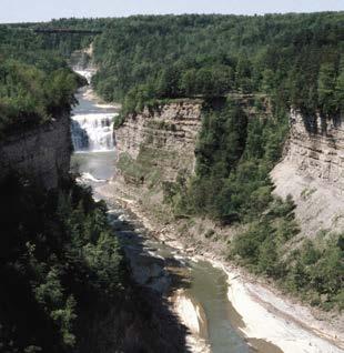
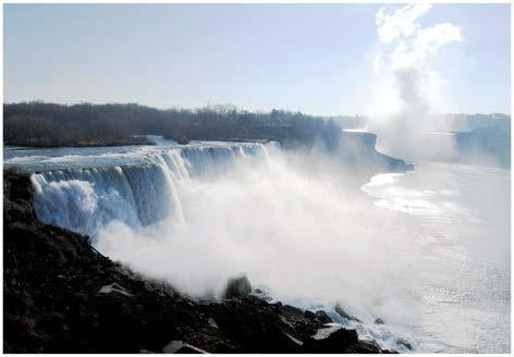
17 Valleys and Canyons Vertical erosion means the valley floor is generally free of alluvium. Alluvium is deposited when base-level is reached or it rises. If base level drops and/or uplift occurs, streams cuts alluvium and forms stream terraces. Raised floodplains 33 Rapids and Waterfalls Rapids: form where the stream flow is constricted - passing over large blacks, narrowing of the channel. This creates turbulence. Waterfalls: escarpments (elevated sections), sometimes caused by a change in base level, faulting, variations in rock type, are removed by erosion and migrate upstream (e.g., Niagara Falls). 34


 cause")


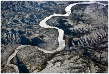
18 Rapids and Waterfalls Niagara Falls: water moves from Lake Erie to Lake Ontario. Drops over a 55 m ledge of hard Silurian dolostone, which is on top of weak shale. Undercutting by the water as it falls (forming a plunge pool) cause migration. 35 Meanders Develop on the floodplain as river changes from vertical to lateral erosion - it wanders over the floodplain. Eventually meanders are cut off and ox-bow lakes form.


19 Natural Levees Meandering streams occupy only a small part of the floodplain, which is typically bounded by eroded bluffs. During floods, the entire floodplain may be immersed. Natural levees are sand ridges that parallel the channel. Natural levee Deltas Form when river enters a body of water and velocity decreases (e.g., Mississippi). The shape is dominated by the river and is a function of: Sediment supply, shifting of river mouth. Waves and currents in the body of water. Tides. On top of a delta, the stream divides into a fan of distributary channels. 38


20 Deltas Sediment deposition builds out the toe of the delta and reduces the gradient. Eventually, the river cannot flow in this channel - the natural levee is topped upstream and the river makes a new path to the sea. This process = avulsion. 39 Deltas Abandoned delta lobes, starved of sediment, slowly compact, dewater, and subside. Abandoned delta lobes are eventually submerged. Subsidence is a problem for cities built on deltas. Subsidence near (or below) sea level magnifies flooding risks. New Orleans is a prime example. 40


21 Deltas Shape of delta controlled by interplay of river discharge and offshore currents. Strong offshore currents do not allow the delta to push into the sea. Deltas named by the Greeks after the Nile Delta - it is an upside down. Birds Foot Delta Weak offshore currents. 41 The Evolution of Drainage: Beveling Topography When base level drops, a new equilibrium is slowly established as streams cut into the former surface, valleys widen, and hills erode. Eventually, the landscape is eroded to the new base level.


22 Stream Rejuvenation Caused by uplift and/or base level drop. Can also cause incised meanders. What are the causes of uplift? What are the causes of base-level drop? 43 Stream Piracy Headward erosion allows one stream to capture another. Can cause a drainage reversal (e.g., the Amazon). 44

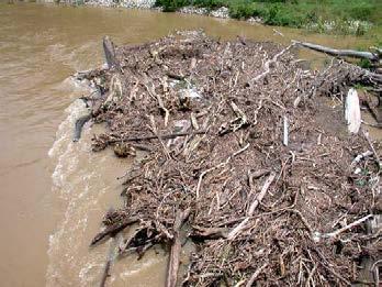
23 Floods Floods happen: 1. During abrupt, heavy rains (water falls faster than it can infiltrate); 2. After long periods of continuous rain (ground is saturated); 3. Heavy snows melt after winter; 4. When an artificial or natural dam breaks. What flood control measures can you name? Flash Floods: floodwaters rise so quickly it may be impossible to escape from their path. Artificial Levees: man-made (mud, sand, concrete). Built along the Mississippi after a major flood (1927 Mississippi Flood Control Act). Dams also built along tributaries to hold flood water back and slowly release it later on. Insufficient to stem the 1993 floods - they were topped and undermined. 45 Floods Artificial levees can be counter-productive. They keep the water in the channel and as it goes downstream, the flood level rises higher than it normally would. Other flood control measures: wetlands (nature s sponges), floodways (areas kept clear of building and development as they will be inundated during flood to reduce the volume of water in the channel), move levees further away so they don t have to be so high. 46


 m n = total number of years for")
24 Floods River data years used. Largest discharge is given a rank of 1, the second largest 2, etc. 1 Annual Probability of Flooding = Recurrence Interval Flood Recurrence Interval (R): Average time hiatus between floods of a given size (e.g., 100 years flood occurs on average every 100 years. However, you can have two 100 year floods in 2 years! R = (n + 1) m n = total number of years for which there is a record; m = rank. Flood of 1% probability = 100 year flood. Use these data to create flood hazard maps for urban planning. 47 Raging Waters: Floods


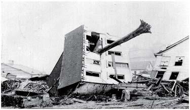
25 Case History of a Seasonal Flood: the Mississippi! and Missouri Rivers, 1993 In the spring of 1993, the jet stream moved over the midwestern United States. This trapped moist humid air from the Gulf of Mexico and rain fell in great abundance. In July of 1993, floodwaters invaded large areas. Flooding lasted 79 days, covering 40,000 square miles. The toll was enormous: 50 people died, 55,000 homes were destroyed, and the damage totaled $12 billion. Rivers: A Vanishing Resource? Pollution: from raw sewage, storm drain water in urban areas, spilled oil, industrial waste, excess fertilizers, animal waste, general trash. Can destroy or radically alter ecosystems and make rivers off-limits. Dam Construction: alters river ecosystems by decreasing water and sediment/ nutrient flow downstream. Positive side - irrigation for agriculture, hydroelectric (clean) power. Urbanization: Increases run-off and peak discharge amounts due to concrete/tarmac (prevents infiltration). 50


, Dry & Productive Wells. Discharge & Turbulence.")

26 Rivers: A Vanishing Resource? Overuse: water taken out of rivers can mean none reaches downstream (e.g., Aral Sea in Central Asia). 51 Summary Hydrologic Cycle. The Basics: River, Reach, Meander, Sheetwash, Chanel Flow, Thalweg, Laminar Flow, Turbulent Flow, Flood Plain, Natural Levee, Banks, Channel. Strem Velocity, Water Table, Springs. Streams & Drainage Networks: Downcutting, Tributaries, Headward Erosion, Dendritic, Radial, Rectangular, Trellis, Superposed Streams, Antecedent Streams, Headwater, Mouth, Divide, Drainage Basin. Permanent & Ephemeral Streams: Dry Wash (Wadi), Dry & Productive Wells. Discharge & Turbulence. Stream Erosion: Dissolution, Scouring, Breaking & Lifting, Abrasion. Stream Transport: Stream Load, Dissolved Load, Clastic Load, Suspended Load, Bed Load, Stream Capacity, Stream Competence, Traction, Saltation. Fluvial Deposition: Alluvium, Bars, Point Bars, Flood Plain, Yazoo Streams, Deltas, Economic Aspects, Braided Streams, Alluvial Fans. River Profiles & Base Level: Longitudinal Profile, Local & Ultimate Base Level, Ungraded & Graded Streams. Valleys & Canyons: Slot Canyon, V-shaped Valley, Stream Terraces. 52 Rapids & Waterfalls: Plunge Pool, Niagara Falls.
27 Summary (cont.) Meanders: Yazoo Streams, Ox-Bow Lakes. Deltas: Avulsion, Distributaries, Topset-Foreset-Bottomset Beds, Natural Levee, Bird-Foot Delta. Stream Rejuvenation: Incised meanders. Stream Piracy: Headward Erosion, Stream Capture. Floods: Causes, Flash Floods, Artificial Levees, Undermining of Levees, Other Flood Control Measures, Flood Recurrence Interval, Flood Hazard Maps. Vanishing Rivers: Pollution, Dam Construction, Urbanization, Overuse. 53
Running Water: The Geology of Streams and Floods Running Water Chapter 14
 Geology 800 Today Running Water: The Geology of Streams and Floods Running Water Chapter 14 Next Class Oceans and Coasts 15 Stream Flow Streams Ribbons of water that flow down channels. Runoff Water in
What do you need for a Marathon?
 What do you need for a Marathon? Water and a snack? What about just a normal day? 1 flush = 3.5 gallons 1 flush = 3.5 gallons 10 minute shower = 20 gal 1 flush = 3.5 gallons 10 minute shower = 20 gal Jeans
Streams. Water. Hydrologic Cycle. Geol 104: Streams
 Streams Why study streams? Running water is the most important geologic agent in erosion, transportation and deposition of sediments. Water The unique physical and chemical properties of water make it
Streams. Stream Water Flow
 CHAPTER 14 OUTLINE Streams: Transport to the Oceans Does not contain complete lecture notes. To be used to help organize lecture notes and home/test studies. Streams Streams are the major geological agents
Running Water Earth - Chapter 16 Stan Hatfield Southwestern Illinois College
 Running Water Earth - Chapter 16 Stan Hatfield Southwestern Illinois College Hydrologic Cycle The hydrologic cycle is a summary of the circulation of Earth s water supply. Processes involved in the hydrologic
11/12/2014. Running Water. Introduction. Water on Earth. The Hydrologic Cycle. Fluid Flow
 Introduction Mercury, Venus, Earth and Mars share a similar history, but Earth is the only terrestrial planet with abundant water! Mercury is too small and hot Venus has a runaway green house effect so
ES 105 Surface Processes I. Hydrologic cycle A. Distribution % in oceans 2. >3% surface water a. +99% surface water in glaciers b.
 ES 105 Surface Processes I. Hydrologic cycle A. Distribution 1. +97% in oceans 2. >3% surface water a. +99% surface water in glaciers b. >1/3% liquid, fresh water in streams and lakes~1/10,000 of water
Erosion Surface Water. moving, transporting, and depositing sediment.
 + Erosion Surface Water moving, transporting, and depositing sediment. + Surface Water 2 Water from rainfall can hit Earth s surface and do a number of things: Slowly soak into the ground: Infiltration
PHYSICAL GEOGRAPHY. By Brett Lucas
 PHYSICAL GEOGRAPHY By Brett Lucas FLUVIAL PROCESSES Fluvial Processes The Impact of Fluvial Processes on the Landscape Streams and Stream Systems Stream Channels Structural Relationships The Shaping and
Chapter 10. Running Water aka Rivers. BFRB Pages
 Chapter 10 Running Water aka Rivers BFRB Pages 101-116 Stream Erosion and Transportation Running water is all precipitation (rain, snow, etc) that falls on Earth and is pulled downhill by gravity. Running
GEOL 1121 Earth Processes and Environments
 GEOL 1121 Earth Processes and Environments Wondwosen Seyoum Department of Geology University of Georgia e-mail: seyoum@uga.edu G/G Bldg., Rm. No. 122 Seyoum, 2015 Chapter 6 Streams and Flooding Seyoum,
Surface Water and Stream Development
 Surface Water and Stream Development Surface Water The moment a raindrop falls to earth it begins its return to the sea. Once water reaches Earth s surface it may evaporate back into the atmosphere, soak
STUDY GUIDE FOR CONTENT MASTERY. Surface Water Movement
 Surface Water SECTION 9.1 Surface Water Movement In your textbook, read about surface water and the way in which it moves sediment. Complete each statement. 1. An excessive amount of water flowing downslope
mountain rivers fixed channel boundaries (bedrock banks and bed) high transport capacity low storage input output
 high transport capacity low storage input output") mountain rivers fixed channel boundaries (bedrock banks and bed) high transport capacity low storage input output strong interaction between streams & hillslopes Sediment Budgets for Mountain Rivers Little
mountain rivers fixed channel boundaries (bedrock banks and bed) high transport capacity low storage input output strong interaction between streams & hillslopes Sediment Budgets for Mountain Rivers Little
Final Exam. Running Water Erosion and Deposition. Willamette Discharge. Running Water
 Final Exam Running Water Erosion and Deposition Earth Science Chapter 5 Pages 120-135 Scheduled for 8 AM, March 21, 2006 Bring A scantron form A calculator Your 3 x 5 paper card of formulas Review questions
WATER ON AND UNDER GROUND. Objectives. The Hydrologic Cycle
 WATER ON AND UNDER GROUND Objectives Define and describe the hydrologic cycle. Identify the basic characteristics of streams. Define drainage basin. Describe how floods occur and what factors may make
STREAM SYSTEMS and FLOODS
 STREAM SYSTEMS and FLOODS The Hydrologic Cycle Precipitation Evaporation Infiltration Runoff Transpiration Earth s Water and the Hydrologic Cycle The Hydrologic Cycle The Hydrologic Cycle Oceans not filling
Precipitation Evaporation Infiltration Earth s Water and the Hydrologic Cycle. Runoff Transpiration
 STREAM SYSTEMS and FLOODS The Hydrologic Cycle Precipitation Evaporation Infiltration Earth s Water and the Hydrologic Cycle Runoff Transpiration The Hydrologic Cycle The Hydrologic Cycle Oceans not filling
Landscape Development
 Landscape Development Slopes Dominate Natural Landscapes Created by the interplay of tectonic and igneous activity and gradation Deformation and uplift Volcanic activity Agents of gradation Mass wasting
Summary. Streams and Drainage Systems
 Streams and Drainage Systems Summary Streams are part of the hydrologic cycle and the chief means by which water returns from the land to the sea. They help shape the Earth s surface and transport sediment
Rivers and Landslides
 Rivers and Landslides Path of desire or path of least resistance? Desire Path: A term in landscape architecture used to describe a path that isn t designed but rather is worn casually away by people finding
FLUVIAL PROCESSES 13 MARCH 2014
 FLUVIAL PROCESSES 13 MARCH 2014 In this lesson we: Lesson Description Look at river profiles, river grading, river rejuvenation as well as the identification, description and formation of fluvial landforms.
GY 111 Lecture Note Series Sedimentary Environments 2: Rivers and Deltas
 GY 111 Lecture Notes D. Haywick (2008-09) 1 GY 111 Lecture Note Series Sedimentary Environments 2: Rivers and Deltas Lecture Goals A) Rivers and Deltas (types) B) Water Flow and sedimentation in river/deltas
Rivers and Streams. Streams. Hydrologic Cycle. Drainage Basins and Divides. Colorado River Drainage Basin. Colorado Drainage Basins.
 Chapter 14 Hydrologic Cycle Rivers and Streams Streams A stream is a body of water that is confined in a channel and moves downhill under the influence of gravity. This definition includes all sizes of
Geography Notes for Plonk Meeting
 Geography Notes for Plonk Meeting Hydrologic Cycle 1. Rainfall Water falls as rain or snow if the air is cold enough. 2. Groundwater Water that seeps into the ground may be absorbed by plants or flow into
EROSION, DEPOSITION AND SEDIMENTARY ROCKS. Reading: Earth Science Tarbuck and Lutgens Chapter 5: pages Chapter 3: pages 52-54, 61-69
 EROSION, DEPOSITION AND SEDIMENTARY ROCKS Reading: Earth Science Tarbuck and Lutgens Chapter 5: pages 124-133 Chapter 3: pages 52-54, 61-69 Base Level Resistant bed Resistant bed creates a local base level
27. Running Water I (p ; )
") 27. Running Water I (p. 424-436; 440-444) Hydrosphere How much of the Earth s surface is covered by water? Earth's water is collectively called the and is stored in a number of so-called as follows: 1.
27. Running Water I (p. 424-436; 440-444) Hydrosphere How much of the Earth s surface is covered by water? Earth's water is collectively called the and is stored in a number of so-called as follows: 1.
Earth Science Chapter 6 Section 2 Review
 Name: Class: Date: Earth Science Chapter 6 Section Review Multiple Choice Identify the choice that best completes the statement or answers the question. 1. Most streams carry the largest part of their
Year 6. Geography. Revision
 Year 6 Geography Revision November 2017 Rivers and World knowledge How the water cycle works and the meaning of the terms evaporation, condensation, precipitation, transpiration, surface run-off, groundwater
Chapter 11. Rivers: Shaping our landscape
 Chapter 11 Rivers: Shaping our landscape Learning outcomes In this presentation you will learn: Common terms associated with rivers About the three stages of a river About the processes of river erosion
Aquifer an underground zone or layer of sand, gravel, or porous rock that is saturated with water.
 Aggradation raising of the streambed by deposition that occurs when the energy of the water flowing through a stream reach is insufficient to transport sediment conveyed from upstream. Alluvium a general
6.1 Water. The Water Cycle
 6.1 Water The Water Cycle Water constantly moves among the oceans, the atmosphere, the solid Earth, and the biosphere. This unending circulation of Earth s water supply is the water cycle. The Water Cycle
Prentice Hall EARTH SCIENCE
 Prentice Hall EARTH SCIENCE Tarbuck Lutgens Running Water and Groundwater Running Water The Water Cycle Water constantly moves among the oceans, the atmosphere, the solid Earth, and the biosphere. This
Lecture Outlines PowerPoint. Chapter 5 Earth Science 11e Tarbuck/Lutgens
 Lecture Outlines PowerPoint Chapter 5 Earth Science 11e Tarbuck/Lutgens 2006 Pearson Prentice Hall This work is protected by United States copyright laws and is provided solely for the use of instructors
3/3/2013. The hydro cycle water returns from the sea. All "toilet to tap." Introduction to Environmental Geology, 5e
 Introduction to Environmental Geology, 5e Running Water: summary in haiku form Edward A. Keller Chapter 9 Rivers and Flooding Lecture Presentation prepared by X. Mara Chen, Salisbury University The hydro
Fresh Water: Streams, Lakes Groundwater & Wetlands
 Fresh Water:, Lakes Groundwater & Wetlands Oct 27 Glaciers and Ice Ages Chp 13 Nov 3 Deserts and Wind and EXAM #3 Slope hydrologic cycle P = precip I = precip intercepted by veg ET = evapotranspiration
Surface Water Short Study Guide
 Name: Class: Date: Surface Water Short Study Guide Multiple Choice Identify the letter of the choice that best completes the statement or answers the question. 1. The three ways in which a stream carries
Laboratory Exercise #3 The Hydrologic Cycle and Running Water Processes
 Laboratory Exercise #3 The Hydrologic Cycle and Running Water Processes page - 1 Section A - The Hydrologic Cycle Figure 1 illustrates the hydrologic cycle which quantifies how water is cycled throughout
Lab 13: Fluvial Processes and Landforms
 Name: Lab 13: Fluvial Processes and Landforms Geomorphology is the study of Earth s surface and of the processes acting to shape it. Streams, for example, are significant continental land-shaping agents.
Environmental Geology Chapter 9 Rivers and Flooding
 Environmental Geology Chapter 9 Rivers and Flooding Flooding in Pakistan 2010-1600 killed/20000 affected The hydrologic cycle is powered by the Sun The cycle includes evaporation, precipitation, infiltration,
 12 10 8 6 4 2 0 40-50 50-60 60-70 70-80 80-90 90-100 Fresh Water What we will cover The Hydrologic Cycle River systems Floods Groundwater Caves and Karst Topography Hot springs Distribution of water in
What is weathering and how does it change Earth s surface? Answer the question using
 7 th Grade Lesson What is weathering and how does it change Earth s surface? Answer the question using the sentence frame. You have 4 minutes. Weathering is. This changes the Earth s surface because. 1
The Hydrologic Cycle STREAM SYSTEMS. Earth s Water and the Hydrologic Cycle. The Hydrologic Cycle. Hydrologic Cycle
 STREAM SYSTEMS Earth Science: Chapter 5 Reading pages 114-124 The Hydrologic Cycle Oceans not filling up Evaporation = precipitation System is balanced Earth s Water and the Hydrologic Cycle Earth s Water
Floods Lecture #21 20
 Floods 20 Lecture #21 What Is a Flood? Def: high discharge event along a river! Due to heavy rain or snow-melt During a flood, a river:! Erodes channel o Deeper & wider! Overflows channel o Deposits sediment
Weathering, Erosion, Deposition, and Landscape Development
 Weathering, Erosion, Deposition, and Landscape Development I. Weathering - the breakdown of rocks into smaller particles, also called sediments, by natural processes. Weathering is further divided into
What are the different ways rocks can be weathered?
 Romano - 223 What are the different ways rocks can be weathered? Weathering - the breakdown of rocks and minerals at the Earth s surface 1. 2. PHYSICAL WEATHERING Rock is broken into smaller pieces with
Rivers. Regents Earth Science Weathering & Erosion
 Regents Earth Science Weathering & Erosion Name: Rivers Use your notes, the handout Weathering and Erosion and your review book to answer the following questions on Rivers. Be sure to read the information
1. The map below shows a meandering river. A A' is the location of a cross section. The arrows show the direction of the river flow.
 1. The map below shows a meandering river. A A' is the location of a cross section. The arrows show the direction of the river flow. Which cross section best represents the shape of the river bottom at
Science of Natural Disasters: RIVERS& FLOODS! 27 April 2016
 Science of Natural Disasters: RIVERS& FLOODS! 27 April 2016 Rebecca Clotts Department of Geology, University of St Thomas Flood in St Paul, 2014, Star Tribune 1 2 What is a watershed? 3 4 5 6 7 What is
RIVERS, GROUNDWATER, AND GLACIERS
 RIVERS, GROUNDWATER, AND GLACIERS Delta A fan-shaped deposit that forms when a river flows into a quiet or large body of water, such as a lake, an ocean, or an inland sea. Alluvial Fan A sloping triangle
NATURAL RIVER. Karima Attia Nile Research Institute
 NATURAL RIVER CHARACTERISTICS Karima Attia Nile Research Institute NATURAL RIVER DEFINITION NATURAL RIVER DEFINITION Is natural stream of water that flows in channels with ih more or less defined banks.
Rivers T. Perron
 1 Rivers T. Perron 12.001 After our discussions of large-scale topography, how we represent topography in maps, and how topography interacts with geologic structures, you should be frothing at the mouth
Section 5. Low-Gradient Streams. What Do You See? Think About It. Investigate. Learning Outcomes
 Chapter 4 Surface Processes Section 5 Low-Gradient Streams What Do You See? Learning Outcomes In this section, you will Use models and real-time streamflow data to understand the characteristics of lowgradient
Mountain Rivers. Gutta cavat lapidem. (Dripping water hollows out a stone) -Ovid, Epistulae Ex Ponto, Book 3, no. 10, 1. 5
 -Ovid, Epistulae Ex Ponto, Book 3, no. 10, 1. 5") Mountain Rivers Gutta cavat lapidem (Dripping water hollows out a stone) -Ovid, Epistulae Ex Ponto, Book 3, no. 10, 1. 5 Mountain Rivers Fixed channel boundaries (bedrock banks and bed) High transport
Mountain Rivers Gutta cavat lapidem (Dripping water hollows out a stone) -Ovid, Epistulae Ex Ponto, Book 3, no. 10, 1. 5 Mountain Rivers Fixed channel boundaries (bedrock banks and bed) High transport
Unit 3 Review - Surface Processes
 Unit 3 Review - Surface Processes 1. Why is the surface of Mercury covered with meteor impact craters, while Earth s surface has relatively few craters? A) Mercury is larger than Earth, so it gets hit
L.O: SLOWING STREAMS DEPOSIT (SORT) SEDIMENT HORIZONTALLY BY SIZE.
 SEDIMENT HORIZONTALLY BY SIZE.") L.O: SLOWING STREAMS DEPOSIT (SORT) SEDIMENT HORIZONTALLY BY SIZE. 1. Base your answer to the following question on the profile shown below, which shows the pattern of horizontal sorting produced at a
L.O: SLOWING STREAMS DEPOSIT (SORT) SEDIMENT HORIZONTALLY BY SIZE. 1. Base your answer to the following question on the profile shown below, which shows the pattern of horizontal sorting produced at a
What we will cover. The Hydrologic Cycle. River systems. Floods. Groundwater. Caves and Karst Topography. Hot springs
 Fresh Water What we will cover The Hydrologic Cycle River systems Floods Groundwater Caves and Karst Topography Hot springs On a piece of paper, put these reservoirs of water in to order from largest to
River/Stream Erosion Notes
 Name Date ES per Mr. Williams River/Stream Erosion Notes Erosion: the of weathered material. FACT: Running water moves more sediment than ANY other type of erosion. 1. The Water Cycle What happens when
1. Any process that causes rock to crack or break into pieces is called physical weathering. Initial product = final product
 Weathering 1. Any process that causes rock to crack or break into pieces is called physical weathering. Initial product = final product End Result of physical weathering is increased surface area. 2. Physical
In the space provided, write the letter of the description that best matches the term or phrase. a. any form of water that falls to Earth s
 Skills Worksheet Concept Review In the space provided, write the letter of the description that best matches the term or phrase. 1. condensation 2. floodplain 3. watershed 4. tributary 5. evapotranspiration
Essential Questions. What is erosion? What is mass wasting?
 Erosion Essential Questions What is erosion? What is mass wasting? What is Erosion? Erosion The transportation of sediment from one area to another Caused mainly by running water but also caused by glaciers,
FLUVIAL LANDFORMS. Floodplains
 FLUVIAL LANDFORMS Floodplains fairly flat & continuous surface occupying much of a valley bottom normally underlain by unconsolidated sediments subject to periodic flooding (usually once every year or
Science EOG Review: Landforms
 Mathematician Science EOG Review: Landforms Vocabulary Definition Term canyon deep, large, V- shaped valley formed by a river over millions of years of erosion; sometimes called gorges (example: Linville
Weathering, Erosion and Deposition
 Weathering, Erosion and Deposition Shaping the Earth s Surface Weathering the process of breaking down rocks into smaller fragments Erosion the transport of rock fragments from one location to another
EROSION AND DEPOSITION
 CHAPTER 8 EROSION AND DEPOSITION SECTION 8 1 Changing Earth s Surface (pages 252-255) This section explains how sediment is carried away and deposited elsewhere to wear down and build up Earth s surface.
Topic 6: Weathering, Erosion and Erosional-Deposition Systems (workbook p ) Workbook Chapter 4, 5 WEATHERING
 Workbook Chapter 4, 5 WEATHERING") Topic 6: Weathering, Erosion and Erosional-Deposition Systems (workbook p. 95-125) Workbook Chapter 4, 5 THE BIG PICTURE: Weathering, erosion and deposition are processes that cause changes to rock material
Topic 6: Weathering, Erosion and Erosional-Deposition Systems (workbook p. 95-125) Workbook Chapter 4, 5 THE BIG PICTURE: Weathering, erosion and deposition are processes that cause changes to rock material
River Systems. Physical Geography Lecture - GEOG B1. Accessible on:
 River Systems Physical Geography Lecture - GEOG B1 Accessible on: www.cherylnail.com Hydrology Hydrology is the scientific study of the movement, distribution, and properties of water on Earth (and other
Physical Geology, 15/e
 Lecture Outlines Physical Geology, 15/e Plummer, Carlson & Hammersley Deserts & Wind Action Physical Geology 15/e, Chapter 13 Deserts Desert any arid region that receives less than 25 cm of precipitation
Lectures Hydrology & Fluvial Geomorphology. Gauley River Images. Ancients' (= Biblical) Model of Water (Hydrologic) Cycle
 Model of Water (Hydrologic) Cycle") Lectures 11-13 13 Hydrology & Fluvial Geomorphology Gauley River Images http://www.youtube.com/watch?v=eulmuyegtz4&feature=related Ancients' (= Biblical) Model of Water (Hydrologic) Cycle Stream Water
Lectures 11-13 13 Hydrology & Fluvial Geomorphology Gauley River Images http://www.youtube.com/watch?v=eulmuyegtz4&feature=related Ancients' (= Biblical) Model of Water (Hydrologic) Cycle Stream Water
Chapter 2. Wearing Down Landforms: Rivers and Ice. Physical Weathering
 Chapter 2 Wearing Down Landforms: Rivers and Ice Physical Weathering Weathering vs. Erosion Weathering is the breakdown of rock and minerals. Erosion is a two fold process that starts with 1) breakdown
Weathering & Erosion
 Weathering & Erosion Weathering and Erosion Weathering - processes at or near Earth s surface that cause rocks and minerals to break down Erosion - process of removing Earth materials from their original
Earth Science Chapter 9. Day 6 - Finish Capillary Action Lab - Quiz over Notes - Review Worksheets over Sections 9.2 and 9.3
 Earth Science Chapter 9 Day 1 Day 2 Day 3 Read Section 9.1 Surface Water Chapter 9 Term Sheet Notes over Section 9.1 Surface Water Section 9.1 Review Worksheets Quiz over Section 9.1 Notes Virtual Lab
River Processes. A) Write definitions for the terms erosion, transportation & deposition.
 Write definitions for the terms erosion, transportation & deposition.") River Processes Lesson Aims To learn what is erosion, transportation and deposition. To learn which processes carry out erosion, transportation and deposition in river systems. Within rivers a number of
River Processes Lesson Aims To learn what is erosion, transportation and deposition. To learn which processes carry out erosion, transportation and deposition in river systems. Within rivers a number of
REVIEW. There are 2 types of WEATHERING: 1. CHEMICAL 2. PHYSICAL. What is WEATHERING? The breakdown of rocks at or near Earth s surface
 REVIEW What is WEATHERING? Def: The breakdown of rocks at or near Earth s surface There are 2 types of WEATHERING: 1. CHEMICAL 2. PHYSICAL CHEMICAL WEATHERING EXAMPLES: 1. OXIDATION (rust) CHEMICAL WEATHERING
Erosion and Deposition
 Erosion and Deposition Erosion Sediment natural forces move rock/soil from one place to another. gravity, water, wind, glaciers, waves are causes material moved by erosion Deposition when erosion lays
1. Erosion by Running Water Most powerful cause of erosion
 I. Destructive Forces Notes: Destructive force: a process in which land is destroyed or changed such as weathering and erosion. All landforms are a result of a combination of constructive and destructive
HW #2 Landscape Travel from A to B 12,
 HW #2 Landscape 2016 Section: Name: ate: 1. ase your answer(s) to the following question(s) on the map below, which represents two bridges that cross the Green River. Letters,, and represent locations
Stream Geomorphology. Leslie A. Morrissey UVM July 25, 2012
 Stream Geomorphology Leslie A. Morrissey UVM July 25, 2012 What Functions do Healthy Streams Provide? Flood mitigation Water supply Water quality Sediment storage and transport Habitat Recreation Transportation
Page 1. Name:
 Name: 1) Which event is the best example of erosion? dissolving of rock particles on a limestone gravestone by acid rain breaking apart of shale as a result of water freezing in a crack rolling of a pebble
Name. 4. The diagram below shows a soil profile formed in an area of granite bedrock. Four different soil horizons, A, B, C, and D, are shown.
 Name 1. In the cross section of the hill shown below, which rock units are probably most resistant to weathering? 4. The diagram below shows a soil profile formed in an area of granite bedrock. Four different
Chapter 2. Denudation: Rivers and Ice
 Chapter 2. Denudation: Rivers and Ice DENUDATION: process that lowers level of land - caused by rivers, glaciers, waves & wind - involves processes of WEATHERING & EROSION Weathering Def: breakdown of
EXTERNAL LAND FORMING PROCESSES
 NAME SCHOOL INDEX NUMBER DATE EXTERNAL LAND FORMING PROCESSES WEATHERING 1 1998 Q 7 (a) (i) What is the difference between weathering and mass wasting (ii) List five processes involved in chemical weathering
Each basin is surrounded & defined by a drainage divide (high point from which water flows away) Channel initiation
 Channel initiation") DRAINAGE BASINS A drainage basin or watershed is defined from a downstream point, working upstream, to include all of the hillslope & channel areas which drain to that point Each basin is surrounded &
DRAINAGE BASINS A drainage basin or watershed is defined from a downstream point, working upstream, to include all of the hillslope & channel areas which drain to that point Each basin is surrounded &
Weathering of Rocks. Weathering - Breakdown of rocks into pieces (sediment) 2 main types of weathering to rocks
 2 main types of weathering to rocks") Weathering of Rocks Weathering - Breakdown of rocks into pieces (sediment) 2 main types of weathering to rocks Mechanical weathering requires physical forces to break rocks into smaller pieces. Chemical
Weathering of Rocks Weathering - Breakdown of rocks into pieces (sediment) 2 main types of weathering to rocks Mechanical weathering requires physical forces to break rocks into smaller pieces. Chemical
every continent has an extensive dry region! " deserts are as much as 1/3 of Earth s surface!
 deserts! deserts! every continent has an extensive dry region! " deserts are as much as 1/3 of Earth s surface! Hollywood portrayal of vast stretches of sand dune! " Sahara has only 10% covered by sand!
Running Water and the Development of Landforms
 Geography IGCSE Module One: River Environments Lesson Thirteen Running Water and the Development of Landforms Aims The aim of this lesson is for you to learn about: processes including o weathering and
Chapter 3 Erosion and Deposition. The Big Question:
 Chapter 3 Erosion and Deposition The Big Question: 1 Design a way to represent and describe the 4 types of mass movement. You may use pictures, diagrams, list, web, chart, etc 2 Chapter 3: Erosion and
SURFACE WATER. Thompson Higher Education 2007; Monroe, Wicander, and Hazlett, Physical Geology en.wikipedia.org
 SURFACE WATER Thompson Higher Education 2007; Monroe, Wicander, and Hazlett, Physical Geology www.google.com en.wikipedia.org KATRINA April 29, 2005 KATRINA April 29, 2005 Golden Canyon, Death Valley,
GEL 109 Midterm W01, Page points total (1 point per minute is a good pace, but it is good to have time to recheck your answers!
 GEL 109 Midterm W01, Page 1 50 points total (1 point per minute is a good pace, but it is good to have time to recheck your answers!) 1. Where in a water flow is there usually a zone of laminar flow even
Erosion and Deposition
 CHAPTER 3 LESSON 2 Erosion and Deposition Landforms Shaped by Water and Wind Key Concepts What are the stages of stream development? How do water erosion and deposition change Earth s surface? How do wind
Earth Science. STREAM DRAINAGE PATTERNS (start by reading the first page of these notes!)
") Name _ Earth Science STREAM DRAINAGE PATTERNS (start by reading the first page of these notes!) WHAT IS A DRAINAGE PATTERN? Streams seek the lowest path as they move downhill, and they tend to erode their
Name _ Earth Science STREAM DRAINAGE PATTERNS (start by reading the first page of these notes!) WHAT IS A DRAINAGE PATTERN? Streams seek the lowest path as they move downhill, and they tend to erode their
Sediment and Sedimentary rock
 Sediment and Sedimentary rock Sediment: An accumulation of loose mineral grains, such as boulders, pebbles, sand, silt or mud, which are not cemented together. Mechanical and chemical weathering produces
UGRC 144 Science and Technology in Our Lives/Geohazards
 UGRC 144 Science and Technology in Our Lives/Geohazards Flood and Flood Hazards Dr. Patrick Asamoah Sakyi Department of Earth Science, UG, Legon College of Education School of Continuing and Distance Education
Weathering, Erosion, Deposition
 Weathering, Erosion, Deposition The breakdown of rocks at or near the Earth s Surface. Physical Chemical - The breakdown of rock into smaller pieces without chemical change. - Dominant in moist /cold conditions
Cattaraugus Creek: A Story of Flowing Water and the Geology of the Channel It Flows Through Presentation to West Valley Citizen Task Force 4/27/16
 Cattaraugus Creek: A Story of Flowing Water and the Geology of the Channel It Flows Through Presentation to West Valley Citizen Task Force 4/27/16 Raymond C. Vaughan, Ph.D. What happens if you drop a
Section I: Multiple Choice Select the best answer to each question. Mark your final answer on the answer sheet. (1 pt each)
") Sedimentary Rocks & Surface Processes Quest Name: Earth Science 2013 Block: Date: Section I: Multiple Choice Select the best answer to each question. Mark your final answer on the answer sheet. (1 pt each)
Sedimentary Rocks & Surface Processes Quest Name: Earth Science 2013 Block: Date: Section I: Multiple Choice Select the best answer to each question. Mark your final answer on the answer sheet. (1 pt each)
Mass Wasting. Revisit: Erosion, Transportation, and Deposition
 Mass Wasting Revisit: Erosion, Transportation, and Deposition While landslides are a normal part of erosion and surface processes, they can be very destructive to life and property! - Mass wasting: downslope
Unit 4: Landscapes Practice Problems
 Name: Date: 1. Soil with the greatest porosity has particles that are A. poorly sorted and densely packed B. poorly sorted and loosely packed C. well sorted and densely packed D. well sorted and loosely
Tips for Success on a Test
 Number of Incorrect: Final Grade: Parent Signature: Top Tips for Success on a Test 1. Read the following statements at least two times. 2. Circle the key words in each question/ or statement. (*Remember
Geog Lecture 19
 Geog 1000 - Lecture 19 Fluvial Geomorphology and River Systems http://scholar.ulethbridge.ca/chasmer/classes/ Today s Lecture (Pgs 346 355) 1. What is Fluvial Geomorphology? 2. Hydrology and the Water