SURFACE WATER. Thompson Higher Education 2007; Monroe, Wicander, and Hazlett, Physical Geology en.wikipedia.org
|
|
|
- Eunice Briggs
- 5 years ago
- Views:
Transcription

1 SURFACE WATER Thompson Higher Education 2007; Monroe, Wicander, and Hazlett, Physical Geology en.wikipedia.org

2 KATRINA April 29, 2005

3 KATRINA April 29, 2005

4 Golden Canyon, Death Valley, California Only 6 cm rain in 4 days can cause flash flooding
5
6 SURFACE WATER AND GROUNDWATER Introduction Water on Earth and the Hydrologic Cycle Rivers, Streams, Lakes, Reservoirs, and Ponds Running Water and Erosion Surface Water Sediment Deposition and Transport Drainage Systems and the Evolution of Valleys

7 Water on Earth and the Hydrologic Cycle Water is in a continuous cycle of movement and phase change; evaporated from the ocean to rise as water vapor, then condensed and precipitated, about 20% falls on land and eventually returns to the oceans largely by surface runoff.
8 The Hydrologic Cycle is powered by thermal energy from the sun, it is a global system where the atmosphere provides the link between the oceans and continents. How does this happen? 1 st Water enters the atmosphere as vapor from land surface by evaporation, transpiration, or volcanism. Evaporation: water that occurs in oceans, lakes or soil is converted by thermal energy into vapor that enters atmosphere Transpiration:the release of water vapor into the atmosphere by plants 2 nd Water vapor in the atmosphere is transported by wind currents and rises to form clouds through condensation 3 rd Saturated clouds yield precipitation (rain, snow, hail, sleet, and fog) 4 th Water that flows atop the land to the ocean is calledrunoff, that which runs in streams, rivers, etc. is running water 5 th Water that infiltratesinto the rocks or soil through cracks and pore spaces is groundwater, which eventually discharges to surface-water bodies

9 Water on Earth 71% of Earth s area consists of oceans and marginal seas like Caribbean and Mediterranean Sea. Most of the ocean waters are in the are in the Southern Hemisphere, about 81 % of the surface water. Oceans hold 97% of Earth s 1.4 billion km 3 total water Most of the remaining 3% is in land glaciers and less than 1% is in atmosphere, surface and groundwater systems at any one time.


10 Earth Sweats Data from the POLAR satellite shows that water vapor and other atmospheric gases are dragged outward at Earth s poles through the ionosphere by solar winds They calculate that one thousand gallons of water per day is being lost, practically nothing given the vast amount of water in the oceans. EOS, August 5, 1997


11 Mars Ablates Ablationis removal of material from the surface of an object by vaporization, chipping, or other erosive processes

12 Water on Earth Stream channels hold less that 1/10,000 % of the water at any time. Channels of all dimensions and volumes are known as streams, and river is usually reserved for large bodies of running water.

13 Rivers, Streams, Lakes, Reservoirs, and Ponds A reservoir (French réservoir a "storehouse") is an artificial lake, storage pond or impoundment from a dam that is used to store water Digital theme of surface water hydrology from the US Geological Survey circa 1995.

14 Lakes, Reservoirs, and Ponds R R L R R A lakeis a large body of fresh water. A pondis a body of water shallow enough to support rooted plants. L R L L R P L L P L R


15 Surface Water Reservoirs The volume of water retained in reservoirs today is so large that if they didn't exist, sea level would be 3 cm higher. These storage bodies have a combined surface area of 500,000 square kilometers, about twice the area of the Great Lakes. EOS, July 19, 1994.


16 Running Water and Erosion Runoff occurs when rainfall intensity exceeds infiltration capacityof the soil. It occurs as either sheet flow or channel flow. channel flow sheet flow
 4. Slope of the land 5.")
17 Infiltration Capacity determines how much water will run into streams. Various factors control infiltration capacity: 1. The intensity and duration of rainfall 2. Prior wetted condition of the soil 3. Soil Texture (size of the soil particles) 4. Slope of the land 5. The nature of the vegetative cover

18 Development of a stream

19 Laminar and turbulent flow Running water moves either by laminar flow in which flow lines parallel one another, or by turbulent flow in which flow lines are complexly intertwined. Most stream flow is turbulent.

20 Stream Gradient A stream's gradient varies from steep to gentle along its course, being steepest near its head and gentlest toward its mouth. Flow velocity increases with gradient

21 Channel shape and stream velocity Flow velocity varies downstream as well as along a cross-section of a stream in response to changes channel roughness, width, and depth, slope and discharge. Arrows are proportional to velocity Flow velocity is the greatest in the center of a stream Semicircular shaped channels have less contact with stream water and thus less frictional resistance to flow


 x cross-sectional area (A) where area")
22 Discharge generally increases downstream due to tributary inputs of water. Discharge (Q) is calculated using weirs and similar methods with reported flows in m 3 or ft 3 per unit of time (sec, hour, or day) Discharge = flow velocity (V) x cross-sectional area (A) where area (A) = width x height for a rectangular area
23

24 Erosion is the wearing away of rock and soil along the river bed and banks Streams erode sediment and rock by hydraulic action, abrasion, and dissolution of soluble rocks. Hydraulic actionis when the river forces air into cracks and crevices, gradually wearing the riverbank away. Abrasionis where rocks get carried along by the river, wearing down its bed and banks. Attritionis when rocks, carried by the river, smash together and break into smaller, smoother particles. Solution is when particles of rock dissolve into, and are transported by streams. rounding through abrasion
 is dissolved by contact with slightly acidic water, like rainwater.")
25 Chemical Weathering Chemical weathering processes include solution, oxidation, and hydrolysis Solutionis when ions in minerals of a solid substance separate, or dissolve when coming into contact with a liquid. A common example is when limestone(impure calcium carbonate) is dissolved by contact with slightly acidic water, like rainwater. Rainwater and shallow groundwater commonly contain small amounts of carbon dioxide (CO 2 ), thereby liberating the hydrogen ions in carbonic acid.


26 Karst and Caves Karst topography is a geological formation shaped by the dissolution of a layer or layers of soluble bedrock, usually carbonate rock such as limestone or dolomite, but has also been documented for weathering-resistant rocks, such as quartzite, given the right conditions.


27 Surface Water Sediment Transport Rivers also transport material by suspension, traction and saltation. Saltationis when small pebbles and stones bounce along the river bed. Suspensionis when fine light material gets carried along. Traction(or creep) is when large boulders and rocks roll along the river bed. water or air current The bed loadof a stream is the coarser sediment component moved along the stream bed, while the finer component which is moved within the water column is known as the suspended load. The dissolved load is those ions which are transported in solution.

28 Surface Water Sediment Deposition and Transport A stream's competenceis a measure of the maximum sediment size which can be carried by a stream, that depends on its velocity. Stream capacityis a measure of the total load transported and is related to the stream's discharge; with greater discharge more sediment can be carried.


29 Roof of the World The Himalayan-Tibet region supplies freshwater for more than one-fifth of the world's population, and accounts for one quarter of the global sedimentation budget. EOS, October 1, 1996


30 Drainage Basins and Topographic Divides Each drainage basin is separated from others by topographic drainage divides. Streams and their tributaries carry runoff from the stream's drainage basin.
 that")

31 Drainage Divides are continuous topographic highs (ridges) that divide and separates water flow from one drainage basin or watershed into another.


32 Alluvium and Drainage Systems River and stream sedimentary deposits are called alluvium. Streams are generally categorized as braidedor meandering

33 Braided Streams have complex divisions and joining of channels Common in arid or semi-arid regions having sparse vegetation and high erosion rates Such stream patterns form where the supply of sediment to stream exceeds its capacity to transport it. Also glacial outwash plains because there is so much sediment


34 Sand and Gravel Bars Bedload sediment is deposited as sand and gravel bars within the stream's channels.
 and deposition on the point bar (the inner bank of the meander loop)")
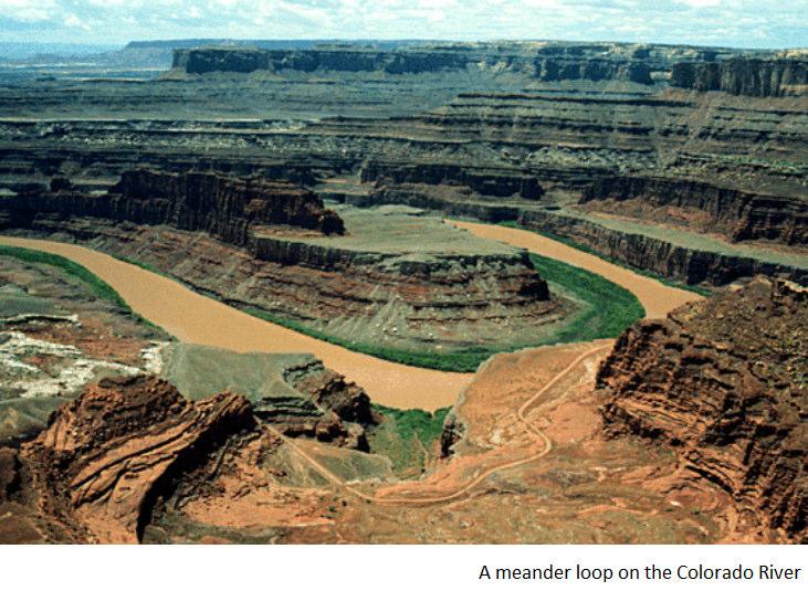
35 Meandering Streams have single channels that are sinuous looping curves Meanders migrate by erosion on the cut bank (the outer bank of the meander loop) and deposition on the point bar (the inner bank of the meander loop)


36 Meandering Streams Oxbow lakes are formed when meander loops are cut off from stream channels. Fine sediment and organic matter accumulates in such lakes.
37 Meandering Streams

38 Floodplain Deposits Floodplainsare the flat lowland areas paralleling streams. Those formed lateral accretion of point bas are mostly made of sand. During floods, streams deposit natural levees, and silt and mud settle from suspension on the floodplain Floodplains can therefore be composed of laterally accreted point bars or the vertical accumulation of fine grained flood-borne deposits.

39 Deltas are alluvial landforms at the mouth of a river, where the river flows into an ocean, sea, estuary, lake, or reservoir. They are formed from the deposition of the sediment carried by the river as the flow leaves the mouth of the river. Small lake deltas usually consist of bottomset, forset, and topset beds

40 Marine Deltas consist of more complex geometries of facies, and are either stream-, tidal- or wave-dominated.

41 Deltas Over long periods of time, sedimentary deposition results in the characteristic geographic pattern of a river delta.

42 Mississippi Delta Growth


43 Alluvial Fans are lobate deposits of gravel and sand deposited on land are known as alluvial fans.

44 Floods are triggered by heavy rain and/or snow melt.

45 Flood Hydrograph The USGS has installed and maintains over 11,000 stream-gauging stations across the country


46 Floods Johnstown Flood of fatalities

47 The Flood of 93 The Jet stream dipped over the Midwest during June and July of 1993 rather than shifting North into Canada as usual. Large, repeated thunderstorms developed from convergence of warm, moist air from the Gulf with cool, dry, air from the North. Satellite images show the difference between normal conditions (1988) and flood conditions at the convergence of the Missouri, Mississippi, and Illinois Rivers


48 Flood Control Measures Oroville Dam, Ca DAMS are used for water-supply, power generation, and flood control Parkersburg, WV ARTIFICAL LEVEES and CHANNELIZATION are designed primarily for flood control

49 Flood Control Measures Oroville Dam, Ca

50 Base Level Streams commonly have local base levels formed by lakes, other streams and resistant bedrock. The lowest level to which streams can erode is sea level, which is known as ultimate base level.

51 Drainage Patterns Dendritic Rectangular Trellis Radial Deranged


52 Graded Streams have gradient, discharge, flow velocity, channel characteristics, and sediment load balanced so that little or no net deposition or erosion occurs in its channel. A change in any of the above parameters upsets the graded condition.
53 Graded Streams Stream erosion and deposition tend toward an equilibrium in which the channel profile is smoothly concave.

54 Stream Valleys develop by the combined processes of downcutting, lateral and headward erosion, mass wasting, and sheetwash. A gulleyis a small steep-sided valley. A canyonis a vast valley with a steep walls or a series of clopes and clifs. Pasture gulley Colorado Canyon

55 Superimposed Streams cut directly across bedrock ridges lying across their paths because they once flowed over a higher surface and have eroded downward to more resistant rocks.

56 Superimposed Streams can be pirated as larger streams in valleys cut down and headward to capture the drainage of smaller streams

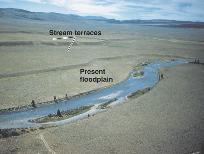
57 Drainage Systems Evolution Incised meanders occupy deep valleys generally as the result of renewed downcutting by meandering streams. Continuous stream downcutting through floodplain deposits commonly results in stream terraces, the remnants of the older higher elevation stream floodplains.

58 Drainage Systems Evolution Continuous stream downcutting through floodplain deposits commonly results in stream terraces, the remnants of the older higher elevation stream floodplains. Incised meanders occupy deep valleys generally as the result of renewed downcutting by meandering streams.
59


60 Landforms Produced by Water on Mars Mars imagery show landforms that scientists have interpreted as being produced by running water. Among the features are gullies forming downslope from a potential seepage horizon and alluvial aprons and alluvial fans. Science, June 30, 2000
61 Lab 8
62
11/12/2014. Running Water. Introduction. Water on Earth. The Hydrologic Cycle. Fluid Flow
 Introduction Mercury, Venus, Earth and Mars share a similar history, but Earth is the only terrestrial planet with abundant water! Mercury is too small and hot Venus has a runaway green house effect so
ES 105 Surface Processes I. Hydrologic cycle A. Distribution % in oceans 2. >3% surface water a. +99% surface water in glaciers b.
 ES 105 Surface Processes I. Hydrologic cycle A. Distribution 1. +97% in oceans 2. >3% surface water a. +99% surface water in glaciers b. >1/3% liquid, fresh water in streams and lakes~1/10,000 of water
Running Water Earth - Chapter 16 Stan Hatfield Southwestern Illinois College
 Running Water Earth - Chapter 16 Stan Hatfield Southwestern Illinois College Hydrologic Cycle The hydrologic cycle is a summary of the circulation of Earth s water supply. Processes involved in the hydrologic
Streams. Stream Water Flow
 CHAPTER 14 OUTLINE Streams: Transport to the Oceans Does not contain complete lecture notes. To be used to help organize lecture notes and home/test studies. Streams Streams are the major geological agents
Streams. Water. Hydrologic Cycle. Geol 104: Streams
 Streams Why study streams? Running water is the most important geologic agent in erosion, transportation and deposition of sediments. Water The unique physical and chemical properties of water make it
Year 6. Geography. Revision
 Year 6 Geography Revision November 2017 Rivers and World knowledge How the water cycle works and the meaning of the terms evaporation, condensation, precipitation, transpiration, surface run-off, groundwater
WATER ON AND UNDER GROUND. Objectives. The Hydrologic Cycle
 WATER ON AND UNDER GROUND Objectives Define and describe the hydrologic cycle. Identify the basic characteristics of streams. Define drainage basin. Describe how floods occur and what factors may make
Erosion Surface Water. moving, transporting, and depositing sediment.
 + Erosion Surface Water moving, transporting, and depositing sediment. + Surface Water 2 Water from rainfall can hit Earth s surface and do a number of things: Slowly soak into the ground: Infiltration
STUDY GUIDE FOR CONTENT MASTERY. Surface Water Movement
 Surface Water SECTION 9.1 Surface Water Movement In your textbook, read about surface water and the way in which it moves sediment. Complete each statement. 1. An excessive amount of water flowing downslope
Final Exam. Running Water Erosion and Deposition. Willamette Discharge. Running Water
 Final Exam Running Water Erosion and Deposition Earth Science Chapter 5 Pages 120-135 Scheduled for 8 AM, March 21, 2006 Bring A scantron form A calculator Your 3 x 5 paper card of formulas Review questions
Surface Water and Stream Development
 Surface Water and Stream Development Surface Water The moment a raindrop falls to earth it begins its return to the sea. Once water reaches Earth s surface it may evaporate back into the atmosphere, soak
6.1 Water. The Water Cycle
 6.1 Water The Water Cycle Water constantly moves among the oceans, the atmosphere, the solid Earth, and the biosphere. This unending circulation of Earth s water supply is the water cycle. The Water Cycle
Landscape Development
 Landscape Development Slopes Dominate Natural Landscapes Created by the interplay of tectonic and igneous activity and gradation Deformation and uplift Volcanic activity Agents of gradation Mass wasting
Weathering, Erosion, Deposition, and Landscape Development
 Weathering, Erosion, Deposition, and Landscape Development I. Weathering - the breakdown of rocks into smaller particles, also called sediments, by natural processes. Weathering is further divided into
27. Running Water I (p ; )
") 27. Running Water I (p. 424-436; 440-444) Hydrosphere How much of the Earth s surface is covered by water? Earth's water is collectively called the and is stored in a number of so-called as follows: 1.
27. Running Water I (p. 424-436; 440-444) Hydrosphere How much of the Earth s surface is covered by water? Earth's water is collectively called the and is stored in a number of so-called as follows: 1.
Prentice Hall EARTH SCIENCE
 Prentice Hall EARTH SCIENCE Tarbuck Lutgens Running Water and Groundwater Running Water The Water Cycle Water constantly moves among the oceans, the atmosphere, the solid Earth, and the biosphere. This
STREAM SYSTEMS and FLOODS
 STREAM SYSTEMS and FLOODS The Hydrologic Cycle Precipitation Evaporation Infiltration Runoff Transpiration Earth s Water and the Hydrologic Cycle The Hydrologic Cycle The Hydrologic Cycle Oceans not filling
Precipitation Evaporation Infiltration Earth s Water and the Hydrologic Cycle. Runoff Transpiration
 STREAM SYSTEMS and FLOODS The Hydrologic Cycle Precipitation Evaporation Infiltration Earth s Water and the Hydrologic Cycle Runoff Transpiration The Hydrologic Cycle The Hydrologic Cycle Oceans not filling
Earth Science Chapter 6 Section 2 Review
 Name: Class: Date: Earth Science Chapter 6 Section Review Multiple Choice Identify the choice that best completes the statement or answers the question. 1. Most streams carry the largest part of their
PHYSICAL GEOGRAPHY. By Brett Lucas
 PHYSICAL GEOGRAPHY By Brett Lucas FLUVIAL PROCESSES Fluvial Processes The Impact of Fluvial Processes on the Landscape Streams and Stream Systems Stream Channels Structural Relationships The Shaping and
Fresh Water: Streams, Lakes Groundwater & Wetlands
 Fresh Water:, Lakes Groundwater & Wetlands Oct 27 Glaciers and Ice Ages Chp 13 Nov 3 Deserts and Wind and EXAM #3 Slope hydrologic cycle P = precip I = precip intercepted by veg ET = evapotranspiration
Lecture Outlines PowerPoint. Chapter 5 Earth Science 11e Tarbuck/Lutgens
 Lecture Outlines PowerPoint Chapter 5 Earth Science 11e Tarbuck/Lutgens 2006 Pearson Prentice Hall This work is protected by United States copyright laws and is provided solely for the use of instructors
mountain rivers fixed channel boundaries (bedrock banks and bed) high transport capacity low storage input output
 high transport capacity low storage input output") mountain rivers fixed channel boundaries (bedrock banks and bed) high transport capacity low storage input output strong interaction between streams & hillslopes Sediment Budgets for Mountain Rivers Little
mountain rivers fixed channel boundaries (bedrock banks and bed) high transport capacity low storage input output strong interaction between streams & hillslopes Sediment Budgets for Mountain Rivers Little
RIVERS, GROUNDWATER, AND GLACIERS
 RIVERS, GROUNDWATER, AND GLACIERS Delta A fan-shaped deposit that forms when a river flows into a quiet or large body of water, such as a lake, an ocean, or an inland sea. Alluvial Fan A sloping triangle
What do you need for a Marathon?
 What do you need for a Marathon? Water and a snack? What about just a normal day? 1 flush = 3.5 gallons 1 flush = 3.5 gallons 10 minute shower = 20 gal 1 flush = 3.5 gallons 10 minute shower = 20 gal Jeans
The Hydrologic Cycle STREAM SYSTEMS. Earth s Water and the Hydrologic Cycle. The Hydrologic Cycle. Hydrologic Cycle
 STREAM SYSTEMS Earth Science: Chapter 5 Reading pages 114-124 The Hydrologic Cycle Oceans not filling up Evaporation = precipitation System is balanced Earth s Water and the Hydrologic Cycle Earth s Water
Surface Processes Focus on Mass Wasting (Chapter 10)
") Surface Processes Focus on Mass Wasting (Chapter 10) 1. What is the distinction between weathering, mass wasting, and erosion? 2. What is the controlling force in mass wasting? What force provides resistance?
Surface Processes Focus on Mass Wasting (Chapter 10) 1. What is the distinction between weathering, mass wasting, and erosion? 2. What is the controlling force in mass wasting? What force provides resistance?
River/Stream Erosion Notes
 Name Date ES per Mr. Williams River/Stream Erosion Notes Erosion: the of weathered material. FACT: Running water moves more sediment than ANY other type of erosion. 1. The Water Cycle What happens when
Laboratory Exercise #3 The Hydrologic Cycle and Running Water Processes
 Laboratory Exercise #3 The Hydrologic Cycle and Running Water Processes page - 1 Section A - The Hydrologic Cycle Figure 1 illustrates the hydrologic cycle which quantifies how water is cycled throughout
GEOL 1121 Earth Processes and Environments
 GEOL 1121 Earth Processes and Environments Wondwosen Seyoum Department of Geology University of Georgia e-mail: seyoum@uga.edu G/G Bldg., Rm. No. 122 Seyoum, 2015 Chapter 6 Streams and Flooding Seyoum,
What is weathering and how does it change Earth s surface? Answer the question using
 7 th Grade Lesson What is weathering and how does it change Earth s surface? Answer the question using the sentence frame. You have 4 minutes. Weathering is. This changes the Earth s surface because. 1
Science EOG Review: Landforms
 Mathematician Science EOG Review: Landforms Vocabulary Definition Term canyon deep, large, V- shaped valley formed by a river over millions of years of erosion; sometimes called gorges (example: Linville
Rivers T. Perron
 1 Rivers T. Perron 12.001 After our discussions of large-scale topography, how we represent topography in maps, and how topography interacts with geologic structures, you should be frothing at the mouth
Surface Water Short Study Guide
 Name: Class: Date: Surface Water Short Study Guide Multiple Choice Identify the letter of the choice that best completes the statement or answers the question. 1. The three ways in which a stream carries
Running Water: The Geology of Streams and Floods Running Water Chapter 14
 Geology 800 Today Running Water: The Geology of Streams and Floods Running Water Chapter 14 Next Class Oceans and Coasts 15 Stream Flow Streams Ribbons of water that flow down channels. Runoff Water in
Chapter 11. Rivers: Shaping our landscape
 Chapter 11 Rivers: Shaping our landscape Learning outcomes In this presentation you will learn: Common terms associated with rivers About the three stages of a river About the processes of river erosion
Name: KEY OBJECTIVES HYDROLOGY:
 Name: KEY OBJECTIVES Correctly define: abrasion, capillarity, deposition, discharge, erosion, evapotranspiration, hydrology, impermeable, infiltration, meander, permeable, porosity, water table, weathering,
Rivers and Landslides
 Rivers and Landslides Path of desire or path of least resistance? Desire Path: A term in landscape architecture used to describe a path that isn t designed but rather is worn casually away by people finding
Chapter 10. Running Water aka Rivers. BFRB Pages
 Chapter 10 Running Water aka Rivers BFRB Pages 101-116 Stream Erosion and Transportation Running water is all precipitation (rain, snow, etc) that falls on Earth and is pulled downhill by gravity. Running
1. Any process that causes rock to crack or break into pieces is called physical weathering. Initial product = final product
 Weathering 1. Any process that causes rock to crack or break into pieces is called physical weathering. Initial product = final product End Result of physical weathering is increased surface area. 2. Physical
Topic 6: Weathering, Erosion and Erosional-Deposition Systems (workbook p ) Workbook Chapter 4, 5 WEATHERING
 Workbook Chapter 4, 5 WEATHERING") Topic 6: Weathering, Erosion and Erosional-Deposition Systems (workbook p. 95-125) Workbook Chapter 4, 5 THE BIG PICTURE: Weathering, erosion and deposition are processes that cause changes to rock material
Topic 6: Weathering, Erosion and Erosional-Deposition Systems (workbook p. 95-125) Workbook Chapter 4, 5 THE BIG PICTURE: Weathering, erosion and deposition are processes that cause changes to rock material
Chapter 2. Wearing Down Landforms: Rivers and Ice. Physical Weathering
 Chapter 2 Wearing Down Landforms: Rivers and Ice Physical Weathering Weathering vs. Erosion Weathering is the breakdown of rock and minerals. Erosion is a two fold process that starts with 1) breakdown
In the space provided, write the letter of the description that best matches the term or phrase. a. any form of water that falls to Earth s
 Skills Worksheet Concept Review In the space provided, write the letter of the description that best matches the term or phrase. 1. condensation 2. floodplain 3. watershed 4. tributary 5. evapotranspiration
EARTH S CHANGING SURFACE
 EARTH S CHANGING SURFACE Weathering Together, weathering and erosion work continuously to wear down the material on Earth s surface. weathering process that breaks down rock and other substances of Earth
Geography Notes for Plonk Meeting
 Geography Notes for Plonk Meeting Hydrologic Cycle 1. Rainfall Water falls as rain or snow if the air is cold enough. 2. Groundwater Water that seeps into the ground may be absorbed by plants or flow into
What are the different ways rocks can be weathered?
 Romano - 223 What are the different ways rocks can be weathered? Weathering - the breakdown of rocks and minerals at the Earth s surface 1. 2. PHYSICAL WEATHERING Rock is broken into smaller pieces with
Weathering & Erosion
 Weathering & Erosion Weathering and Erosion Weathering - processes at or near Earth s surface that cause rocks and minerals to break down Erosion - process of removing Earth materials from their original
EROSION, DEPOSITION AND SEDIMENTARY ROCKS. Reading: Earth Science Tarbuck and Lutgens Chapter 5: pages Chapter 3: pages 52-54, 61-69
 EROSION, DEPOSITION AND SEDIMENTARY ROCKS Reading: Earth Science Tarbuck and Lutgens Chapter 5: pages 124-133 Chapter 3: pages 52-54, 61-69 Base Level Resistant bed Resistant bed creates a local base level
Weathering, Erosion and Deposition
 Weathering, Erosion and Deposition Shaping the Earth s Surface Weathering the process of breaking down rocks into smaller fragments Erosion the transport of rock fragments from one location to another
EROSION AND DEPOSITION
 CHAPTER 8 EROSION AND DEPOSITION SECTION 8 1 Changing Earth s Surface (pages 252-255) This section explains how sediment is carried away and deposited elsewhere to wear down and build up Earth s surface.
4. The map below shows a meandering stream. Points A, B, C, and D represent locations along the stream bottom.
 1. Sediment is deposited as a river enters a lake because the A) velocity of the river decreases B) force of gravity decreases C) volume of water increases D) slope of the river increases 2. Which diagram
Karst Topography In order to understand karst topography we must first have a basic understanding of the water cycle, the formation of limestone (carb
 Karst Topography The formation of caves and other associated features in limestone bedrock is called karst topography. Limestone, a sedimentary rock made mostly of the mineral calcite and small amounts
Summary. Streams and Drainage Systems
 Streams and Drainage Systems Summary Streams are part of the hydrologic cycle and the chief means by which water returns from the land to the sea. They help shape the Earth s surface and transport sediment
 12 10 8 6 4 2 0 40-50 50-60 60-70 70-80 80-90 90-100 Fresh Water What we will cover The Hydrologic Cycle River systems Floods Groundwater Caves and Karst Topography Hot springs Distribution of water in
Which map shows the stream drainage pattern that most likely formed on the surface of this volcano? A) B)
 B)") 1. When snow cover on the land melts, the water will most likely become surface runoff if the land surface is A) frozen B) porous C) grass covered D) unconsolidated gravel Base your answers to questions
1. When snow cover on the land melts, the water will most likely become surface runoff if the land surface is A) frozen B) porous C) grass covered D) unconsolidated gravel Base your answers to questions
Section I: Multiple Choice Select the best answer to each question. Mark your final answer on the answer sheet. (1 pt each)
") Sedimentary Rocks & Surface Processes Quest Name: Earth Science 2013 Block: Date: Section I: Multiple Choice Select the best answer to each question. Mark your final answer on the answer sheet. (1 pt each)
Sedimentary Rocks & Surface Processes Quest Name: Earth Science 2013 Block: Date: Section I: Multiple Choice Select the best answer to each question. Mark your final answer on the answer sheet. (1 pt each)
What we will cover. The Hydrologic Cycle. River systems. Floods. Groundwater. Caves and Karst Topography. Hot springs
 Fresh Water What we will cover The Hydrologic Cycle River systems Floods Groundwater Caves and Karst Topography Hot springs On a piece of paper, put these reservoirs of water in to order from largest to
Page 1. Name:
 Name: 1) Which event is the best example of erosion? dissolving of rock particles on a limestone gravestone by acid rain breaking apart of shale as a result of water freezing in a crack rolling of a pebble
Surface Events & Landforms. Mrs. Green
 Surface Events & Landforms Mrs. Green Bell Work 1) Which event MOST likely causes the slowest change to the surface of Earth? a) Earthquake b) Landslide c) Volcano d) Wind 2) When cold weather freezes
1. The map below shows a meandering river. A A' is the location of a cross section. The arrows show the direction of the river flow.
 1. The map below shows a meandering river. A A' is the location of a cross section. The arrows show the direction of the river flow. Which cross section best represents the shape of the river bottom at
Earth Science Chapter 9. Day 6 - Finish Capillary Action Lab - Quiz over Notes - Review Worksheets over Sections 9.2 and 9.3
 Earth Science Chapter 9 Day 1 Day 2 Day 3 Read Section 9.1 Surface Water Chapter 9 Term Sheet Notes over Section 9.1 Surface Water Section 9.1 Review Worksheets Quiz over Section 9.1 Notes Virtual Lab
FLUVIAL LANDFORMS. Floodplains
 FLUVIAL LANDFORMS Floodplains fairly flat & continuous surface occupying much of a valley bottom normally underlain by unconsolidated sediments subject to periodic flooding (usually once every year or
Chapter 2. Denudation: Rivers and Ice
 Chapter 2. Denudation: Rivers and Ice DENUDATION: process that lowers level of land - caused by rivers, glaciers, waves & wind - involves processes of WEATHERING & EROSION Weathering Def: breakdown of
River Processes. Learning Objective: Discover how a river erodes, transports and deposits material
 River Processes Learning Objective: Discover how a river erodes, transports and deposits material Learning Outcomes: Compare vertical and lateral erosion Describe how a river erodes, transports and deposits
What factors affect the angle of a slope?
 Climate Rock type and Structure What factors affect the angle of a slope? Aspect Fast mass movements Slides: Slides are movements along the SLIP PLANE, i.e. a line of weakness in the rock or soil structure.
10/27/2014. Surface Processes. Surface Processes. Surface Processes. Surface Processes. Surface Processes
 Hewitt/Lyons/Suchocki/Yeh Conceptual Integrated Science Chapter 25 Surface or surficial processes originate at Earth's surface and reshape its contours. Surface processes include: Weathering Erosion Deposition
Mountain Rivers. Gutta cavat lapidem. (Dripping water hollows out a stone) -Ovid, Epistulae Ex Ponto, Book 3, no. 10, 1. 5
 -Ovid, Epistulae Ex Ponto, Book 3, no. 10, 1. 5") Mountain Rivers Gutta cavat lapidem (Dripping water hollows out a stone) -Ovid, Epistulae Ex Ponto, Book 3, no. 10, 1. 5 Mountain Rivers Fixed channel boundaries (bedrock banks and bed) High transport
Mountain Rivers Gutta cavat lapidem (Dripping water hollows out a stone) -Ovid, Epistulae Ex Ponto, Book 3, no. 10, 1. 5 Mountain Rivers Fixed channel boundaries (bedrock banks and bed) High transport
Rivers and Streams. Streams. Hydrologic Cycle. Drainage Basins and Divides. Colorado River Drainage Basin. Colorado Drainage Basins.
 Chapter 14 Hydrologic Cycle Rivers and Streams Streams A stream is a body of water that is confined in a channel and moves downhill under the influence of gravity. This definition includes all sizes of
Chapter 3 Erosion and Deposition. The Big Question:
 Chapter 3 Erosion and Deposition The Big Question: 1 Design a way to represent and describe the 4 types of mass movement. You may use pictures, diagrams, list, web, chart, etc 2 Chapter 3: Erosion and
3/3/2013. The hydro cycle water returns from the sea. All "toilet to tap." Introduction to Environmental Geology, 5e
 Introduction to Environmental Geology, 5e Running Water: summary in haiku form Edward A. Keller Chapter 9 Rivers and Flooding Lecture Presentation prepared by X. Mara Chen, Salisbury University The hydro
Ecoregions Glossary. 7.8B: Changes To Texas Land Earth and Space
 Ecoregions Glossary Ecoregions The term ecoregions was developed by combining the terms ecology and region. Ecology is the study of the interrelationship of organisms and their environments. The term,
1. Erosion by Running Water Most powerful cause of erosion
 I. Destructive Forces Notes: Destructive force: a process in which land is destroyed or changed such as weathering and erosion. All landforms are a result of a combination of constructive and destructive
Unit 3 Review - Surface Processes
 Unit 3 Review - Surface Processes 1. Why is the surface of Mercury covered with meteor impact craters, while Earth s surface has relatively few craters? A) Mercury is larger than Earth, so it gets hit
Name. 4. The diagram below shows a soil profile formed in an area of granite bedrock. Four different soil horizons, A, B, C, and D, are shown.
 Name 1. In the cross section of the hill shown below, which rock units are probably most resistant to weathering? 4. The diagram below shows a soil profile formed in an area of granite bedrock. Four different
Lectures Hydrology & Fluvial Geomorphology. Gauley River Images. Ancients' (= Biblical) Model of Water (Hydrologic) Cycle
 Model of Water (Hydrologic) Cycle") Lectures 11-13 13 Hydrology & Fluvial Geomorphology Gauley River Images http://www.youtube.com/watch?v=eulmuyegtz4&feature=related Ancients' (= Biblical) Model of Water (Hydrologic) Cycle Stream Water
Lectures 11-13 13 Hydrology & Fluvial Geomorphology Gauley River Images http://www.youtube.com/watch?v=eulmuyegtz4&feature=related Ancients' (= Biblical) Model of Water (Hydrologic) Cycle Stream Water
Environmental Geology Chapter 9 Rivers and Flooding
 Environmental Geology Chapter 9 Rivers and Flooding Flooding in Pakistan 2010-1600 killed/20000 affected The hydrologic cycle is powered by the Sun The cycle includes evaporation, precipitation, infiltration,
Erosion and Deposition
 Erosion and Deposition Erosion Sediment natural forces move rock/soil from one place to another. gravity, water, wind, glaciers, waves are causes material moved by erosion Deposition when erosion lays
Changing Earth s Surface
 Name Date Class Changing Earth s Surface What processes wear down and build up Earth s surface? What causes the different types of mass movement? Erosion is the process by which natural forces move weathered
Chapter 23 test. Multiple Choice Identify the choice that best completes the statement or answers the question. Figure 23-1
 Chapter 23 test Multiple Choice Identify the choice that best completes the statement or answers the question. Figure 23-1 1. In Figure 23-1, what process does the arrow labeled A represent? a. transpiration
Figure 1 The map shows the top view of a meandering stream as it enters a lake. At which points along the stream are erosion and deposition dominant?
 1. In which type of climate does chemical weathering usually occur most rapidly? 1. hot and dry 3. cold and dry 2. hot and wet 4. cold and wet 2. Figure 1 The map shows the top view of a meandering stream
Sediment and sedimentary rocks Sediment
 Sediment and sedimentary rocks Sediment From sediments to sedimentary rocks (transportation, deposition, preservation and lithification) Types of sedimentary rocks (clastic, chemical and organic) Sedimentary
The Official CA State Science Education Standards for Earth Science K 8
 The Official CA State Science Education Standards for Earth Science K 8 Kindergarten The Earth is composed of land, air and water. As a basis for understanding this concept, students know: a. characteristics
Earth s Dynamic Surface
 Earth s Dynamic Surface Key Concepts What is the difference between physical and chemical weathering? How do water, ice, and wind change Earth s surface? Changing Earth s Surface What do you think? Read
Depositional Environment
 Depositional Environment Sedimentary depositional environment describes the combination of physical, chemical and biological processes associated with the deposition of a particular type of sediment. Types
Weathering, Erosion, Deposition
 Weathering, Erosion, Deposition The breakdown of rocks at or near the Earth s Surface. Physical Chemical - The breakdown of rock into smaller pieces without chemical change. - Dominant in moist /cold conditions
Erosion and Deposition
 CHAPTER 3 LESSON 2 Erosion and Deposition Landforms Shaped by Water and Wind Key Concepts What are the stages of stream development? How do water erosion and deposition change Earth s surface? How do wind
The Agents of Erosion
 The Agents of Erosion 1. Erosion & Deposition 2. Water 3. Wind 4. Ice California Science Project 1 1. Erosion and Deposition Erosion is the physical removal and transport of material by mobile agents such
UNIT 4: Earth Science Chapter 21: Earth s Changing Surface (pages )
") CORNELL NOTES Directions: You must create a minimum of 5 questions in this column per page (average). Use these to study your notes and prepare for tests and quizzes. Notes will be turned in to your teacher
CORNELL NOTES Directions: You must create a minimum of 5 questions in this column per page (average). Use these to study your notes and prepare for tests and quizzes. Notes will be turned in to your teacher
Geog Lecture 19
 Geog 1000 - Lecture 19 Fluvial Geomorphology and River Systems http://scholar.ulethbridge.ca/chasmer/classes/ Today s Lecture (Pgs 346 355) 1. What is Fluvial Geomorphology? 2. Hydrology and the Water
Aquifer an underground zone or layer of sand, gravel, or porous rock that is saturated with water.
 Aggradation raising of the streambed by deposition that occurs when the energy of the water flowing through a stream reach is insufficient to transport sediment conveyed from upstream. Alluvium a general
GY 111 Lecture Note Series Sedimentary Environments 2: Rivers and Deltas
 GY 111 Lecture Notes D. Haywick (2008-09) 1 GY 111 Lecture Note Series Sedimentary Environments 2: Rivers and Deltas Lecture Goals A) Rivers and Deltas (types) B) Water Flow and sedimentation in river/deltas
Land and Water Summative Assessment. Name Date
 Land and Water Summative Assessment Name Date Read each question carefully and select the best answer. 1. Abby built a model to study how rain changes the land. She shaped the land into single, smooth
abrasion the rubbing, grinding, and bumping of rocks that cause physical weathering (SRB, IG)
") FOSS Soils, Rocks, and Landforms Module Glossary NGSS Edition 2019 abrasion the rubbing, grinding, and bumping of rocks that cause physical weathering (SRB, IG) acid a substance that geologists use to
FOSS Soils, Rocks, and Landforms Module Glossary NGSS Edition 2019 abrasion the rubbing, grinding, and bumping of rocks that cause physical weathering (SRB, IG) acid a substance that geologists use to
Bell Ringer. Are soil and dirt the same material? In your explanation be sure to talk about plants.
 Bell Ringer Are soil and dirt the same material? In your explanation be sure to talk about plants. 5.3 Mass Movements Triggers of Mass Movements The transfer of rock and soil downslope due to gravity is
GEOG 1010A. Come to the PASS workshop with your mock exam complete. During the workshop you can work with other students to review your work.
 It is most beneficial to you to write this mock midterm UNDER EXAM CONDITIONS. This means: Complete the midterm in 1.5 hours. Work on your own. Keep your notes and textbook closed. Attempt every question.
Practice 3rd Quarter Exam Page 1
 Name 1. Which characteristic would most likely remain constant when a limestone cobble is subjected to extensive abrasion? A) shape B) mass C) volume D) composition 2. Which activity demonstrates chemical
1. Which type of climate has the greatest amount of rock weathering caused by frost action? A) a wet climate in which temperatures remain below
 a wet climate in which temperatures remain below") 1. Which type of climate has the greatest amount of rock weathering caused by frost action? A) a wet climate in which temperatures remain below freezing B) a wet climate in which temperatures alternate
1. Which type of climate has the greatest amount of rock weathering caused by frost action? A) a wet climate in which temperatures remain below freezing B) a wet climate in which temperatures alternate
Surface Processes. Water Cycle. Evaporation Transpiration Condenstation Precipitation Infiltration Runoff
 s e s s roce S P e c urfa s e s s e c o r P e s c d r a a f C r Su iew Note v e R Water Cycle Evaporation Transpiration Condenstation Precipitation Infiltration Runoff Runoff The moving of water along
True or False: The Earth s surface has stayed the same for thousands of years
 True or False: The Earth s surface has stayed the same for thousands of years True or False: The Earth s surface has stayed the same for thousands of years The Earth s surface is always changing! Weathering
Water Erosion (pages )
") Water Erosion (pages 272 281) Runoff and Erosion (pages 273 274) Key Concept: Moving water is the major agent of the erosion that has shaped Earth s land surface. Falling raindrops can loosen and pick
Water Erosion (pages 272 281) Runoff and Erosion (pages 273 274) Key Concept: Moving water is the major agent of the erosion that has shaped Earth s land surface. Falling raindrops can loosen and pick