VT EPSCoR Streams Project: Highlights & Future Plans. Streams Project Symposium April 27, 2009
|
|
|
- Jasmin Payne
- 5 years ago
- Views:
Transcription


1 VT EPSCoR Streams Project: Highlights & Future Plans Streams Project Symposium April 27, 2009

2 What is the Streams Project? Collaborative effort by high schools, colleges and community partners around the state to collect water quality data on small streams

3 Goals of the Project 1) Service to the state of Vermont Collect water quality data on streams of importance to VT 2) Workforce Development Interaction of faculty, undergraduates, high school teachers and students Practical experience in scientific research
 How does water quality change in response to precipitation events?")
4 Research Questions 1) How does surrounding land use, specifically agricultural, forested and urban land use, affect water quality in small streams? 2) How does water quality change in response to precipitation events?


5 Participants High Schools (14) collect biological, physical and chemical data in streams near their schools UVM (7) * work with high schools * do laboratory analysis of water samples * carry out independent project Baccalaureate College Faculty (3) & Undergraduates (14) Complementary research projects with community partners or working with high school data
6
7 Colleges involved St. Michael s College Middlebury College Johnson State College Sterling College Norwich University Green Mountain College Universidad Metropolitana University of Puerto Rico ( ) Baruch College, NY ( ) Castleton College ( )
8 2008 Accomplishments ~ 30 streams studied throughout Lake Champlain Basin Online database in development 11 undergraduates attended national research meetings: 5 St. Michael s College to Benthic Ecology Conference, Corpus Christi, TX 3 Universidad Metropolitana to SACNAS Annual Conference, Salt Lake City, UT 3 UVM and 3 St. Michael s students presented posters at NSF EPSCoR National Water Conference, Burlington, VT 1 High School student participated in VT State Science Fair; recognized as one of top 3 environmental projects New Partnerships with Puerto Rico


9 Galleries specific to school sites Photographic ID help 2008 Accomplishments
10 Mean number of EPT species per sample lide from Brian Cunningham 2008 Data: Land use, water quality and insects Mean number of E.coli cells per sample
11 lide from Jackie Cote Average Number of Species 2008 Data: Land use and Species Abudance P-value = URBAN FORESTED AGRICULTURE Land Use Figure 1. Average number of benthic macroinvertebrate species collected and identified per land use category in summer months of 2008 for Vermont streams.
12 2008 Data: E. coli Source Tracking G. Perry, T. Thurston and R. Genter Johnson State College
13 So, what s Next?

14 Streams Project High Schools 27 Undergraduates 11 from Baccalaureate colleges 8 from UVM 8 from Puerto Rico 7 faculty research projects 1-2 Private Sector Participants
15 Projects Application of the Index of Biotic Similarity to Streams Project Macroinvertebrate Data (Norwich University) Bioassessment of Wild Branch of the Lamoille River (Sterling College) Chemistry of Dog River Watershed (Norwich University) Development of Biotic Integrity Index using Larval Cyprinidae (Green Mountain College & Castleton College) Development of map-based educational tools for High School students and teachers (Middlebury College) Microbial Source Tracking and Phosphorus in Lamoille River tributaries (Johnson State College) Creating a sequence library for E. coli collected in streams (Middlebury College) Related project: An evaluation of phosphorus flux and effects of land use on macroinvertebrate communities in tributaries of St. Albans Bay (St. Michael s College)


16 Lexie Reiss Haselton VT EPSCoR Streams Project Symposium 2009 Lexie Haselton, VT EPSCoR
17 What is spatial analysis? How can we use spatial analysis in the VT EPSCoR Streams Project?
18

19
20 Landscape variables % of land in each land use type % of land with specific soil types Bedrock geology Aspect of catchment area (N, W, E, S orientation) Sinuosity of stream segment upstream Distance of site to point source pollution Elevation, or slope Building density Road density Climate data

21
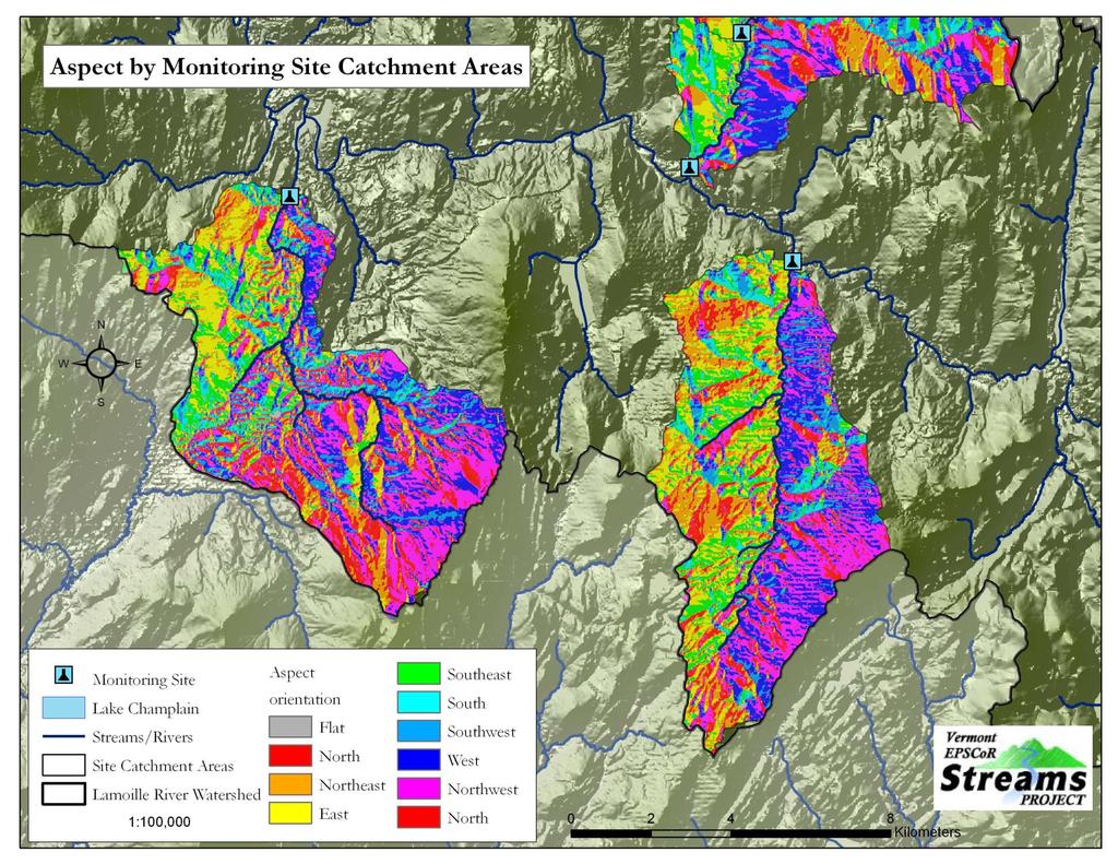
22
23

24

25

26
27

28
29 Summer Goals: GPS points Map-based discussion of landscape-level variables Ground truthing spatial data by catchment area Compilation of spatial data layers Spatial analysis using field data and spatial data
30 Special thanks to Christopher Willey, HELiX/EPSCoR Nora Joyal, Troy Krahl, Chris Frieman, Lillian Gamache, VT EPSCoR; and Gayle Bress, HELiX/EPSCoR Sherri Neumann, Sheraton Hotel & Conference Center Lexie Haselton, VT EPSCoR GIS Specialist All of you for coming!
How Do Geology and Physical Streambed Characteristics Affect Water Quality?
 Teacher s Guide How Do Geology and Physical Streambed Characteristics Affect Water Quality? Lesson Description In this lesson, the students research a dynamic, vertical dimension of a watershed - the geological
Understanding the effects of roads in upland settings on hydrology, geomorphology and water quality
 Understanding the effects of roads in upland settings on hydrology, geomorphology and water quality Beverley Wemple Department of Geography and Rubenstein School of Environment & Natural Resources The
Vermont Geological Survey s Impact on Public Issues: Geologic Mapping Applied to Hazards and Water
 Vermont Geological Survey s Impact on Public Issues: Geologic Mapping Applied to Hazards and Water Presented by: Marjorie Gale, Vermont State Geologist 1 Jonathan Kim 1, George Springston 2, Colin Dowey
The Road to Data in Baltimore
 Creating a parcel level database from high resolution imagery By Austin Troy and Weiqi Zhou University of Vermont, Rubenstein School of Natural Resources State and local planning agencies are increasingly
Evolution of Post-Glacial Lake Ecosystems in Northern New England: a Geochemical Study using Lake Sediments
 Evolution of Post-Glacial Lake Ecosystems in Northern New England: a Geochemical Study using Lake Sediments Andrea M. Lord Department of Geology University of Vermont Burlington, VT 05405 November 13,
Tropical Montane Cloud Forests: Importance and Challenges in a Changing Environment
 Tropical Montane Cloud Forests: Importance and Challenges in a Changing Environment Daniel E. Comarazamy and Jorge E. González The NOAA-CREST Center & Department of Mechanical Engineering, City College
 Permafrost http://www.cbc.ca/news/canada/story/2011/11/16/north-bigfix-permafrost.html 1. What is permafrost? Permafrost is a thick layer of permanently frozen ground. 2. Large parts of northeastern Russia
Hydrological Observatory description. Lisbon. Atlantic Ocean
 Sado river, Portugal Location The Sado River is located in the southwest of Portugal and it is the largest river that entirely flows in the Portuguese territory. The river originates at the south of the
GIS and Coastal Nutrients Luke Cole
 GIS and Coastal Nutrients Luke Cole Human population density has been widely utilized as a valid predictor of terrestrial nitrogen loads into marine systems. As 50% of the world s population lives within
Lecture 3. Data Sources for GIS in Water Resources
 Lecture 3 Data Sources for GIS in Water Resources GIS in Water Resources Spring 2015 http://www.data.gov/ 1 USGS GIS data for Water http://water.usgs.gov/maps.html Watersheds of the US 2-digit water resource
Benjamin James Hatchett As of March 2011
 Benjamin James Hatchett Benjamin.Hatchett@dri.edu 530-307-9044 As of March 2011 Education University of Nevada, Reno Mackay School of Earth Sciences and Engineering B.S. (With Distinction) Geography, minor
Geography and the Early Settlement of China
 Geography and the Early Settlement of I N T E R A C T I V E S T U D E N T N O T E B O O K How did geography affect life in ancient? P R E V I E W Physical Features 1. Circle the physical features that
USGS Hydrography Overview. May 9, 2018
 + 1 USGS Hydrography Overview May 9, 2018 + 2 The National Geospatial Program Provides the geospatial baseline of the Nation s topography, natural landscape and built environment through The National Map,
Multi-scale modeling of species distributions, hydrology, & gene flow
 Multi-scale modeling of species distributions, hydrology, & gene flow Douglas R. Leasure PhD. Candidate University of Arkansas Department of Biological Sciences BIG data in GIS http://www.gap.uidaho.edu/portal/datadownload.html
Chapter 6 Mapping and Online Tools
 Chapter 6 Mapping and Online Tools The stream site you monitor is just part of a much larger system. When analyzing stream health, it is important to take a holistic view by considering the entire watershed.
ADDRESSING GEOMORPHIC AND HYDRAULIC CONTROLS IN OFF-CHANNEL HABITAT DESIGN
 ADDRESSING GEOMORPHIC AND HYDRAULIC CONTROLS IN OFF-CHANNEL HABITAT DESIGN Conor Shea - Hydrologist U.S. Fish and Wildlife Service Conservation Partnerships Program Arcata, CA Learning Objectives Examine
Living in a Watershed
 Living in a Watershed Department of Ecosystem Science and Ma... http://ecosystems.psu.edu/youth/sftrc/lesson-plans/water/k-5/watershed Department of Ecosystem Science and Management Youth Living in a Watershed
Stream Geomorphology. Leslie A. Morrissey UVM July 25, 2012
 Stream Geomorphology Leslie A. Morrissey UVM July 25, 2012 What Functions do Healthy Streams Provide? Flood mitigation Water supply Water quality Sediment storage and transport Habitat Recreation Transportation
Use of benthic invertebrate biological indicators in evaluating sediment deposition impairment on the Middle Truckee River, California
 Use of benthic invertebrate biological indicators in evaluating sediment deposition impairment on the Middle Truckee River, California David B. Herbst Sierra Nevada Aquatic Research Laboratory University
CAUSES FOR CHANGE IN STREAM-CHANNEL MORPHOLOGY
 CAUSES FOR CHANGE IN STREAM-CHANNEL MORPHOLOGY Chad A. Whaley, Department of Earth Sciences, University of South Alabama, MobileAL, 36688. E-MAIL: caw408@jaguar1.usouthal.edu The ultimate goal of this
A New Class of Spatial Statistical Model for Data on Stream Networks: Overview and Applications
 A New Class of Spatial Statistical Model for Data on Stream Networks: Overview and Applications Jay Ver Hoef Erin Peterson Dan Isaak Spatial Statistical Models for Stream Networks Examples of Autocorrelated
Application of GIS Technology in Watershed-based Management and Decision Making
 Application of GIS Technology in Watershed-based Management and Decision Making U. Sunday Tim Iowa State University Department of Agricultural and Biosystems Engineering 100 Davidson Hall Email:
Pierce Cedar Creek Institute GIS Development Final Report. Grand Valley State University
 Pierce Cedar Creek Institute GIS Development Final Report Grand Valley State University Major Goals of Project The two primary goals of the project were to provide Matt VanPortfliet, GVSU student, the
Distinct landscape features with important biologic, hydrologic, geomorphic, and biogeochemical functions.
 1 Distinct landscape features with important biologic, hydrologic, geomorphic, and biogeochemical functions. Have distinguishing characteristics that include low slopes, well drained soils, intermittent
Physical Geography: Patterns, Processes, and Interactions, Grade 11, University/College Expectations
 Geographic Foundations: Space and Systems SSV.01 explain major theories of the origin and internal structure of the earth; Page 1 SSV.02 demonstrate an understanding of the principal features of the earth
Vulnerability assessment of Sta.Rosa-Silang subwatershed using SWAT
 Vulnerability assessment of Sta.Rosa-Silang subwatershed using SWAT Damasa B. Magcale-Macandog, Charles Gunay and Milben A. Bragais Institute of Biological Sciences, University of the Philippines Los Baños,
GIS Changing the World GIS Day November 15, 2017
 + GIS Changing the World GIS Day November 15, 2017 + Growing Up On The Farm 3 Geographic Information in DNR A 75 year history of mapping and GIS. Forest type map from 1944. State of Washington - Division
Urban Wetlands. Hooking students to Geosciences. Solomon A. Isiorho Prof. of Geosciences Indiana University Purdue University Ft.
 Urban Wetlands Hooking students to Geosciences Solomon A. Isiorho Prof. of Geosciences Indiana University Purdue University Ft. Wayne, IPFW isiorho@ipfw.edu Presented at the Urban Students, Urban Issues:
Which map shows the stream drainage pattern that most likely formed on the surface of this volcano? A) B)
 B)") 1. When snow cover on the land melts, the water will most likely become surface runoff if the land surface is A) frozen B) porous C) grass covered D) unconsolidated gravel Base your answers to questions
1. When snow cover on the land melts, the water will most likely become surface runoff if the land surface is A) frozen B) porous C) grass covered D) unconsolidated gravel Base your answers to questions
BASIS FOR RIVER RESTORATION PROJECT
 The FLUVIO FCT-Doctoral Program Hydromorphological and Habitat Restoration Course Diego García de Jalón and Marta González del Tánago, UPM Madrid BASIS FOR RIVER RESTORATION PROJECT Throughout the course,
COMMUNITY SERVICE AREA
 INSTITUTE FOR TRIBAL ENVIRONMENTAL PROFESSIONALS Tribal Waste and Response Assistance Program (TWRAP) Developing and Implementing a Tribal Integrated Solid Waste Management Plan April 12-14, 2016 Palm
Sedimentation Rate Change in the Winooski River Delta
 Sedimentation Rate Change in the Winooski River Delta Chris Ricker and Brian Connelly Abstract Historical air photographs, from 1937 show the Winooski River Delta extended much farther into Lake Champlain
United States Department of the Interior NATIONAL PARK SERVICE Northeast Region
 United States Department of the Interior NATIONAL PARK SERVICE Northeast Region June 17, 2017 REQUEST FOR STATEMENTS OF INTEREST and QUALIFICATIONS Project Title: ASSESSMENT OF NATURAL RESOURCE CONDITION
cooperating sites as the three initial units of a new Southern Appalachian Biosphere Reserve, approved by UNESCO in 1988.
 -» TOWARD A U.S. MODALITY OF BIOSPHERE RESERVES: THE SOUTHERN APPALACHIAN BIOSPHERE RESERVE William s_ P. Gregg, Chief, International Affairs Office, National Biological Service, Washington, D.C. Hubert
Introduction. Elevation Data Strategy. Status and Next Steps
 1 2 Introduction Elevation Data Strategy Status and Next Steps 3 Canada is the 2nd largest country in the world - 9.9 million sq km Surrounded by 3 oceans with 202 000 km of coastline Population over 35
USING HYPERSPECTRAL IMAGERY
 USING HYPERSPECTRAL IMAGERY AND LIDAR DATA TO DETECT PLANT INVASIONS 2016 ESRI CANADA SCHOLARSHIP APPLICATION CURTIS CHANCE M.SC. CANDIDATE FACULTY OF FORESTRY UNIVERSITY OF BRITISH COLUMBIA CURTIS.CHANCE@ALUMNI.UBC.CA
PHASE 1 STREAM GEOMORPHIC ASSESSMENT. Castleton River, Rutland County Vermont. Final Report
 PHASE 1 STREAM GEOMORPHIC ASSESSMENT Castleton River, Rutland County Vermont Final Report September 15, 2005 TABLE OF CONTENTS INTRODUCTION.. 3 STUDY AREA BACKGROUND... 5 METHODOLOGY 5 DATA INPUTS/STUDY
STM Development: A Systematic Approach Focused on Quality Control
 STM Development: A Systematic Approach Focused on Quality Control A Lofty Aspiration Tamzen K. Stringham University of Nevada, Reno Multiple Approaches Dig lots of holes - I will figure this out! Hang
Education. Research and Teaching Interests. Academic Appointments. May 2017 Athens, GA
 Paul W. Miller Department of Geography University of Georgia 210 Field St, Room 304 Athens, GA 30602 540 642 2463 paul.miller@uga.edu www.paulmillergeo.com Education Doctorate of Philosophy, Geography
APPENDIX PHASE 1 GREEN INFRASTRUCTURE FRAMEWORK
 APPENDIX PHASE 1 GREEN INFRASTRUCTURE FRAMEWORK KANSAS MISSOURI CONTENTS A DATA WISHLIST 4 B PRECEDENTS 7 C WORKSHOP MATERIALS 13 D ANALYSIS PROCESS 124 E ATLAS & PLAYBOOK DETAILS 156 F POLICY ANALYSIS
Brian D. George. GIMS Specialist Ohio Coastal Atlas Project Coordinator and Cartographer. Impacts and Outcomes of Mature Coastal Web Atlases
 Ohio Coastal Atlas Project Brian D. George GIMS Specialist Ohio Coastal Atlas Project Coordinator and Cartographer Ohio Department of Natural Resources Office of Coastal Management Sandusky, OH Impacts
Building a Spatial Framework for the Analysis of Benthic Fauna Along the River Network of Switzerland
 Building a Spatial Framework for the Analysis of Benthic Fauna Along the River Network of Switzerland Lehmann 1 A., S., Stucki 2 P. and Gonseth 3 Y. 1 University of Geneva, 2 private consultancy, 3 CSCF
NOAA s OCM: Services, tools and collaboration opportunities & Puerto Rico s NE Marine Corridor as a case study
 NOAA s OCM: Services, tools and collaboration opportunities & Puerto Rico s NE Marine Corridor as a case study Dr. Antares Ramos Álvarez NOAA s Office of Coastal Management September 15 th, 2016 Conservation
Hydrologic Modelling of the Upper Malaprabha Catchment using ArcView SWAT
 Hydrologic Modelling of the Upper Malaprabha Catchment using ArcView SWAT Technical briefs are short summaries of the models used in the project aimed at nontechnical readers. The aim of the PES India
GIS Mapping of Dominica Study Abroad. Kinnie Eijsink Dominica Topical Field Biology 2010 Texas A&M University
 GIS Mapping of Dominica Study Abroad Kinnie Eijsink Dominica Topical Field Biology 2010 Texas A&M University Abstract Geographic Information Systems is a technology being employed more and more often as
Poverty Mapping, Policy Making and Operations
 Poverty Mapping, Policy Making and Operations Some Applications from Kenya (DECDG) Using Poverty Maps to Design Better Policies and Interventions Washington DC May 11, 2006 Outline Poverty Mapping process
CURRICULUM VITAE OF SAMUEL ADU-PRAH
 CURRICULUM VITAE OF SAMUEL ADU-PRAH I. PROFESSIONAL AFFILIATION AND CONTACT INFORMATION A. Lecturer GIS Lab Director-Environmental GIS & Advanced Geospatial Analysis Labs Southern Illinois University Carbondale
FOREST ECOSYSTEM ANALYSIS USING A GIS' S.G. McNulty and W.T. Swank USDA Forest Service Coweeta Hydrologic Laboratory Otto,NC USA ABSTRACT
 FOREST ECOSYSTEM ANALYSIS USING A GIS' S.G. McNulty and W.T. Swank USDA Forest Service Coweeta Hydrologic Laboratory Otto,NC USA ABSTRACT Forest ecosystem studies have expanded spatially in recent years
Landscape approaches for understanding and managing lakes. Dr. Kendra Spence Cheruvelil Scottish Freshwater Group 24 October 2013
 Landscape approaches for understanding and managing lakes Dr. Kendra Spence Cheruvelil Scottish Freshwater Group 24 October 2013 Making inferences from well studied ecosystems Variable Time Lake (data)
Basin-scale analysis of long-term sediment-generation rates derived from 10 Be in river sediment:
 Basin-scale analysis of long-term sediment-generation rates derived from 10 Be in river sediment: The Susquehanna River basin and beyond Joanna M. Reuter M.S. Proposal April 30, 2003 Paul Bierman, advisor
Atlas of the Upper Gila River Watershed
 Atlas of the Upper Gila River Watershed Katie Banister, David Chan, Jessica M. Driscoll, Christopher Fullerton, Aaron Lien and Kelly Mott Lacroix January 2014 The University of Arizona Water Resources
Plant Distribution in a Sonoran Desert City CAP LTER Data Explorations
 in a Sonoran Desert City CAP LTER Data Explorations Author: Ecology Explorers Team, adapted from data analysis by J. Walker and the CAP LTER 200 point survey Time: 15-30 minutes Grade Level: 9-12 Background:
Laboratory Exercise #3 The Hydrologic Cycle and Running Water Processes
 Laboratory Exercise #3 The Hydrologic Cycle and Running Water Processes page - 1 Section A - The Hydrologic Cycle Figure 1 illustrates the hydrologic cycle which quantifies how water is cycled throughout
Fig 1. Steps in the EcoValue Project
 Assessing the Social and Economic Value of Ecosystem Services in the Northern Forest Region: A Geographic Information System (GIS) Approach to Landscape Valuation Principal Investigator(s): Dr. Matthew
UNIT4. Ancient China. Geography and the Early Settlement of China. Three Chinese Philosophies The First Emperor of China
 UNIT4 Ancient China Lesson 19 Lesson 20 Lesson 21 Lesson 22 Lesson 23 Lesson 24 Geography and the Early Settlement of China The Shang Dynasty Three Chinese Philosophies The First Emperor of China The Han
Water Quality and Water Quantity: Two sides of the Same Coin. Chris Jones
 Water Quality and Water Quantity: Two sides of the Same Coin Chris Jones Unit of the College of Engineering Director: Larry Weber 90 Graduate Students from 16 countries 61 Research Engineers and Scientists
2014 Arizona State University, School of Geographical Sciences and Urban Planning Lounsbury Travel Award. $350
 Heather A. Fischer Arizona State University School of Geographical Sciences and Urban Planning P.O. Box 875302 Tempe, AZ 85287-5302 (801) 870-3365 heather.fischer@asu.edu https://sites.google.com/a/asu.edu/heatherafischer/
The Refugia Concept: Using Watershed Analysis to Prioritize Salmonid Habitat for Conservation and Restoration
 The Refugia Concept: Using Watershed Analysis to Prioritize Salmonid Habitat for Conservation and Restoration Christopher May Battelle & UW Cumulative Impacts of Urbanization Landscape Alterations Loss
Development and Land Use Change in the Central Potomac River Watershed. Rebecca Posa. GIS for Water Resources, Fall 2014 University of Texas
 Development and Land Use Change in the Central Potomac River Watershed Rebecca Posa GIS for Water Resources, Fall 2014 University of Texas December 5, 2014 Table of Contents I. Introduction and Motivation..4
Rong Jiang. Map of River. Table of Basic Data. China 14. Serial No. : China-14
 Rong Jiang Map of River Table of Basic Data Name(s): Rong Jiang Location: Guangdong Province, Coastways China Area: 4,408 km 2 Serial No. : China-14 N 23 11' ~ 23 55' E 115 37' ~ 116 38' Length of the
Keanahalululu Gulch, Hawaiÿi
 DAR Watershed Code: 85021 WATERSHED FEATURES Keanahalululu Gulch watershed occurs on the island of Hawaiÿi. The Hawaiian meaning of the name is unknown. The area of the watershed is 4.1 square mi (10.6
Soil Erosion Calculation using Remote Sensing and GIS in Río Grande de Arecibo Watershed, Puerto Rico
 Soil Erosion Calculation using Remote Sensing and GIS in Río Grande de Arecibo Watershed, Puerto Rico Alejandra M. Rojas González Department of Civil Engineering University of Puerto Rico at Mayaguez.
HYDROLOGIC AND WATER RESOURCES EVALUATIONS FOR SG. LUI WATERSHED
 HYDROLOGIC AND WATER RESOURCES EVALUATIONS FOR SG. LUI WATERSHED 1.0 Introduction The Sg. Lui watershed is the upper part of Langat River Basin, in the state of Selangor which located approximately 20
POPULATION DEMOGRAPHICS IN DOG RIVER WATERSHED OVER TIME
 POPULATION DEMOGRAPHICS IN DOG RIVER WATERSHED OVER TIME Kal-El Q. Waters-Jones, Department of Earth Sciences, University of South Alabama, Mobile, AL 36688. E-mail: kwatersjones@yahoo.com. Over time,
Alaska ACE Education Programs
 Alaska ACE Education Programs Elena Bautista Sparrow, Tania Clucas, Holly McQueen, Sarai, Timothy, Chip McMuellen, Gary Kofinas, Sanjay Pyare, Andy Kliskey, Tom Moran, Alan Boraas, John Monahan, Denise
RR#5 - Free Response
 Base your answers to questions 1 through 3 on the data table below and on your knowledge of Earth Science. The table shows the area, in million square kilometers, of the Arctic Ocean covered by ice from
What s New in Topographic Information - USGS National Map
 + What s New in Topographic Information - USGS National Map SARGIS Workshop November 14, 2016 Rob Dollison, 703-648-5724 rdollison@usgs.gov + USGS 2 National Geospatial Program The National Geospatial
Vermont Stream Geomorphic Assessment. Appendix E. River Corridor Delineation Process. VT Agency of Natural Resources. April, E0 - April, 2004
 Vermont Stream Geomorphic Assessment Appendix E River Corridor Delineation Process Vermont Agency of Natural Resources - E0 - River Corridor Delineation Process Purpose A stream and river corridor delineation
Final Report. COMET Partner's Project. University of Texas at San Antonio
 Final Report COMET Partner's Project University: Name of University Researcher Preparing Report: University of Texas at San Antonio Dr. Hongjie Xie National Weather Service Office: Name of National Weather
April snowmelt and record rainfall resulted in flooding across portions of Vermont
 Vermont State Climate Office Climate Impacts Summary April 2011 Dr. Lesley-Ann Dupigny-Giroux Stephen Hogan April snowmelt and record rainfall resulted in flooding across portions of Vermont During the
Monitoring and evaluation of benthic macroinvertebrates in the Big Hole River and tributaries
 Monitoring and evaluation of benthic macroinvertebrates in the Big Hole River and tributaries Michael A. Bias Big Hole River Foundation Introduction BMI used to evaluate stream biological health Quantifies
PROGRESS REPORT for COOPERATIVE BOBCAT RESEARCH PROJECT. Period Covered: 1 January 31 May Prepared by
 PROGRESS REPORT for COOPERATIVE BOBCAT RESEARCH PROJECT Period Covered: 1 January 31 May 2011 Prepared by John A. Litvaitis, Derek Broman, and Marian K. Litvaitis Department of Natural Resources University
StreamStats: Delivering Streamflow Information to the Public. By Kernell Ries
 StreamStats: Delivering Streamflow Information to the Public By Kernell Ries U.S. Department of the Interior U.S. Geological Survey MD-DE-DC District 410-238-4317 kries@usgs.gov StreamStats Web Application
Sediment and nutrient transport and storage along the urban stream corridor
 Sediment and nutrient transport and storage along the urban stream corridor Greg Noe, Cliff Hupp, Ed Schenk, Jackie Batson, Nancy Rybicki, Allen Gellis What is the role of floodplains everywhere? Noe 2013,
An introduction to thee Urban Oases Site Selection Tool:
 An introduction to thee Urban Oases Site Selection Tool: Created by Audubon Connecticut with assistance from a GIS Consultant/Research Assistant at the Harvard Forest Essential input provided by the New
Assessing Michigan s Biological diversity. Michigan Natural Features Inventory MSU Extension
 Assessing Michigan s Biological diversity John Paskus,, Amy Derosier,, Edward Schools, and Helen Enander Michigan Natural Features Inventory MSU Extension Goal Provide scientifically based information
Esri s Living Atlas of the World Community Maps
 Esri s Living Atlas of the World Community Maps Seth Sarakaitis Wednesday May 7, 2014 ArcGIS Living Atlas Concept Living Atlas Content Tour Contributing to the Living Atlas (Community Maps) Seth Sarakaitis
Critical Loads of Acidity Database This project was funded, in part, by the USDA Forest Service National Forest System National Air Technical Program.
 Critical Loads of Acidity Database This project was funded, in part, by the USDA Forest Service National Forest System National Air Technical Program. Database Overview This database was created to provide
Development of a Fluvial Erosion Hazard Mitigation Program for Indiana
 Development of a Fluvial Erosion Hazard Mitigation Program for Indiana Indiana Watersheds Webinar Series October 12,2011 Robert Barr Center for Earth and Environmental Science Department of Earth Sciences
Application of an Enhanced, Fine-Scale SWAT Model to Target Land Management Practices for Maximizing Pollutant Reduction and Conservation Benefits
 Application of an Enhanced, Fine-Scale SWAT Model to Target Land Management Practices for Maximizing Pollutant Reduction and Conservation Benefits Amanda Flynn, Todd Redder, Joe DePinto, Derek Schlea Brian
Classification of Erosion Susceptibility
 GEO327G: GIS & GPS Applications in Earth Sciences Classification of Erosion Susceptibility Denali National Park, Alaska Zehao Xue 12 3 2015 2 TABLE OF CONTENTS 1 Abstract... 3 2 Introduction... 3 2.1 Universal
Date of Report: EPA agreement number: Center Name and Institution of Ctr. Director: Identifier used by Center for Project: Title of Project:
 Date of Report: March 31, 2003 EPA agreement number: R829515C003 Center Name and Institution of Ctr. Director: Rocky Mountain Regional Hazardous Substance Research Center, Colorado State University, Fort
Watershed concepts for community environmental planning
 Purpose and Objectives Watershed concepts for community environmental planning Dale Bruns, Wilkes University USDA Rural GIS Consortium May 2007 Provide background on basic concepts in watershed, stream,
Floodplain modeling. Ovidius University of Constanta (P4) Romania & Technological Educational Institute of Serres, Greece
 Romania & Technological Educational Institute of Serres, Greece") Floodplain modeling Ovidius University of Constanta (P4) Romania & Technological Educational Institute of Serres, Greece Scientific Staff: Dr Carmen Maftei, Professor, Civil Engineering Dept. Dr Konstantinos
Floodplain modeling Ovidius University of Constanta (P4) Romania & Technological Educational Institute of Serres, Greece Scientific Staff: Dr Carmen Maftei, Professor, Civil Engineering Dept. Dr Konstantinos
Jim Fox. copyright UNC Asheville's NEMAC
 Decisions and System Thinking Jim Fox November, 2012 1 UNC Asheville s s NEMAC National Environmental Modeling and Analysis Center Applied Research and technology development on integration of environmental
Spatial units (Levels 0 and 1)
") Spatial units (Levels 0 and 1) Project: Advancing the SEEA Experimental Ecosystem Accounting Overview: Spatial units 1. Learning objectives 2. Level 1: Presentation & group exercise Spatial units (10m
Spatial units (Levels 0 and 1) Project: Advancing the SEEA Experimental Ecosystem Accounting Overview: Spatial units 1. Learning objectives 2. Level 1: Presentation & group exercise Spatial units (10m
06/04/2015. Overview: Spatial units. Advancing the SEEA Experimental Ecosystem Accounting Spatial units (Level 1)
") Advancing the SEEA Experimental Ecosystem Accounting Spatial units (Level 1) Advancing the SEEA-EEA Project Overview: Spatial units 1. Learning objectives 2. Level 1: Presentation & group exercise Spatial
Advancing the SEEA Experimental Ecosystem Accounting Spatial units (Level 1) Advancing the SEEA-EEA Project Overview: Spatial units 1. Learning objectives 2. Level 1: Presentation & group exercise Spatial
GIS in Water Resources Midterm Exam Fall 2008 There are 4 questions on this exam. Please do all 4.
 Page 1 of 8 Name: GIS in Water Resources Midterm Exam Fall 2008 There are 4 questions on this exam. Please do all 4. 1. Basic Concepts [20 points] Find the letter with the best answer for each term: 1.
ENVS S102 Earth and Environment (Cross-listed as GEOG 102) ENVS S110 Introduction to ArcGIS (Cross-listed as GEOG 110)
 ENVS S110 Introduction to ArcGIS (Cross-listed as GEOG 110)") ENVS S102 Earth and Environment (Cross-listed as GEOG 102) 1. Describe the fundamental workings of the atmospheric, hydrospheric, lithospheric, and oceanic systems of Earth 2. Explain the interactions
ENVS S102 Earth and Environment (Cross-listed as GEOG 102) 1. Describe the fundamental workings of the atmospheric, hydrospheric, lithospheric, and oceanic systems of Earth 2. Explain the interactions
Mapping Water Resources and Reservoirs for Climate Resilience in Zambezi River Basin
 Mapping Water Resources and Reservoirs for Climate Resilience in Zambezi River Basin Corné van der Sande, NEO BV Senior Advisor Earth Observation Services for Monitoring Drought and Water Resources in
ROAD SEDIMENT ASSESSMENT & MODELING: KOOTENAI-FISHER TMDL PLANNING AREA ROAD GIS LAYERS & SUMMARY STATISTICS
 ROAD SEDIMENT ASSESSMENT & MODELING: KOOTENAI-FISHER TMDL PLANNING AREA ROAD GIS LAYERS & SUMMARY STATISTICS Prepared by: ATKINS Water Resources Group 820 North Montana Avenue Helena, MT 59601 November
Development of a GIS Interface for WEPP Model Application to Great Lakes Forested Watersheds
 Development of a GIS Interface for WEPP Model Application to Great Lakes Forested Watersheds J.R. Frankenberger 1, S. Dun 2, D.C. Flanagan 1, J.Q. Wu 2, W.J. Elliot 3 1 USDA-ARS, West Lafayette, IN 2 Washington
Techniques for Science Teachers: Using GIS in Science Classrooms.
 Techniques for Science Teachers: Using GIS in Science Classrooms. After ESRI, 2008 GIS A Geographic Information System A collection of computer hardware, software, and geographic data used together for
Developed new methodologies for mapping and characterizing suburban sprawl in the Northeastern Forests
 Development of Functional Ecological Indicators of Suburban Sprawl for the Northeastern Forest Landscape Principal Investigator: Austin Troy UVM, Rubenstein School of Environment and Natural Resources
Session 2: Exploring GIS
 EMB/RTC-GIS/Event 2/Session 2/1 Session 2: Exploring GIS Map Production - Exploring various GIS functions Objectives: 1. To create a map layer Air Pollution Index (API) and its attribute table 2. To symbolize
The Thoreau Institute at Walden Woods Library. The Edmund A. Schofield Collection. Maps and Oversize Items. A Guide to the Collection
 The Thoreau Institute at Walden Woods Library The Edmund A. Schofield Collection Maps and Oversize Items A Guide to the Collection The Walden Woods Project 2009 [Updated: July 2012] COLLECTION SUMMARY
Spatial Units (Level 1)
") Spatial Units (Level 1) Project: Advancing the SEEA Experimental Ecosystem Accounting Overview: Spatial Units 1. Learning objectives 2. Review of Level 0 (5m) 3. Level 1 (Compilers): Presentation & group
Spatial Units (Level 1) Project: Advancing the SEEA Experimental Ecosystem Accounting Overview: Spatial Units 1. Learning objectives 2. Review of Level 0 (5m) 3. Level 1 (Compilers): Presentation & group
Climate Change Impact Assessment on Long Term Water Budget for Maitland Catchment in Southern Ontario
 215 SWAT CONFERENCE, PURDUE Climate Change Impact Assessment on Long Term Water Budget for Maitland Catchment in Southern Ontario By Vinod Chilkoti Aakash Bagchi Tirupati Bolisetti Ram Balachandar Contents
GIS Mapping for Hubbard Brook Experimental Forest A Service Learning Project for Plymouth Regional High School Environmental Science
 GIS Mapping for Hubbard Brook Experimental Forest A Service Learning Project for Plymouth Regional High School Environmental Science Hubbard Brook Experimental Forest [External Link], established in 1955
Land Accounts - The Canadian Experience
 Land Accounts - The Canadian Experience Development of a Geospatial database to measure the effect of human activity on the environment Who is doing Land Accounts Statistics Canada (national) Component