EO-MINERS and Minerals 4EU
|
|
|
- Susanna Ray
- 5 years ago
- Views:
Transcription


1 GEO-CRADLE pre-kick-off Meeting Friday, 18 th of February, 2016 Veronika Kopačková, Czech Geological Survey EO-MINERS and Minerals 4EU IONIC Centre, 11 Lysiou Street Athens, Greece
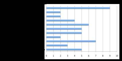
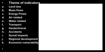
2 EO-MINERS ( ) EO-MINERS was a Research and Technological Developement project funded by the European Commission To help EC improve its raw material policy and better exploiting mineral resources from the European territory To demonstrate how to improve the capacity of Europe in implementing new mining sites To improve interaction between the mining industry and society Sientifc objective 1: Define environmental, socio-economic, societal and sustainable development criteria and indicators to be possibly dealt with EO Scientific objective 2: Demonstrate the capabilities of integrated EO-based methods and tools in: monitoring, managing Contributing to reducing the environmental and societal footprints of all phases of a mining project
3 EO-MINERS ( ) Beneficiary name Country Beneficiary name Country (BRGM) Bureau de Recherches Géologiques et Minières France Coordination Council for Geoscience South Africa British Geological Survey UK Anglo Operations Limited, Anglo Technical Division Tel-Aviv University Israel Université de Versailles St Quentin South Africa France Deutsches Zentrum für Luft - und Raumfahrt e.v. Wuppertal Institut für Klima, Umwelt, Energie GmbH Germany Česká Geologická Služba Czech Republic Germany Sokolovská Uhelná a.s. Czech Republic Geoloski Zavod Slovenije Slovenia Central Asian Institute for Applied Geoscience Mineral Industry Research Organisation Kyrgyzstan UK KyrgyzAltyn Kyrgyzstan
 Anglo Technical Division Tel-Aviv University Israel Université de Versailles St FR(2) Quentin South Africa France Deutsches Zentrum für")
4 EO-MINERS ( ) Beneficiary name Country Beneficiary name Country (BRGM) Bureau de Recherches Géologiques et Minières France Coordination DE(2) Council for Geoscience CZ(2) KG(2) South Africa British Geological Survey UK Anglo Operations Limited, UK(2) Anglo Technical Division Tel-Aviv University Israel Université de Versailles St FR(2) Quentin South Africa France Deutsches Zentrum für Luft - und Raumfahrt e.v. Wuppertal Institut für Klima, Umwelt, Energie GmbH Germany Česká Geologická Služba Czech Republic SI(1) Germany Sokolovská Uhelná IL(1) a.s. Czech Republic Geoloski Zavod Slovenije Slovenia Central Asian Institute for Applied Geoscience ZA(2) Mineral Industry Research Organisation Kyrgyzstan UK KyrgyzAltyn Kyrgyzstan 3 demonstration sites (CZ, ZA, KG)


5 EO-MINERS ( ) Expert knowledge Indicators EO methods and tools EO-based monitoring products On-site investigations Stakeholder interviews Trialogue workshops Stakeholder feedback

6 EO-MINERS ( ) <event>, <date>, <venue>
7 EO-MINERS: product list Validated Products Indicator Dust pollution and vegetation health Acid mine drainage contamination potential Spatial distribution of iron oxides possibly associated with acid mine drainage Fe content of water and acid mine drainage Soil composition and acid mine drainage-producing minerals Air Quality: aerosol concentration in off-site air Land-use: recultivation success on mined-out areas Water Quality: acid drainage generation potential Water Quality: acid drainage generation potential Water Quality: acid drainage generation potential Soil properties and water quality: acid drainage generation potential and Soil fertility <event>, <date>, <venue>

 Each with associated information and validation histories <event>,")
8 EO-MINERS: EO product types Project results are provided in a number of form, each designed to explain results to a range of stakeholders Reports Digital layers Paper maps Digital maps Animated fly-throughs Sokolov (Czech Republic) Witbank (South Africa) Makmal (Kyrgystan) Each with associated information and validation histories <event>, <date>, <venue>
9 EO-MINERS: product list Dust pollution and vegetation health <event>, <date>, <venue>


10 EO-MINERS: product list Mineral Mapping used for water quality assessment Dust pollution and vegetation health <event>, <date>, <venue>
11 Minerals 4EU Develop an EU Mineral intelligence network structure delivering a web portal, a European Minerals Yearbook and foresight studies Establish the EU minerals intelligence network structure, comprising European minerals data providers and stakeholders Support decision making on the policy and adaptation strategies of the Commission, as well as supporting the security of EU resource and raw material Make this the leading European mineral information network structure that will provide tools and expertise to enhance resource efficiency, minerals supply security and support sustainable mineral development for Europe
12 Minerals 4EU <event>, <date>, <venue>


13 Minerals 4EU <event>, <date>, <venue>
14 Minerals 4EU Metada catalogue application (CGS) Metadata Catalogue application The central access point to metadata concerning European mineral resources and related topics;

15 Minerals 4EU Metada catalogue application (CGS) Metadata Catalogue application The central access point to metadata concerning European mineral resources and related topics;
16 Minerals 4EU: achievements European Minerals Knowledge Data Platform (EU-MKDP) A simplified, user-friendly and efficient access to all available and new data related to mineral resources through the 'Minerals4EU' Knowledge Data Platform Interactive, easy to use contains a wider range of data than ever before attempted


17 Minerals 4EU: achievements European Minerals Knowledge Data Platform (EU-MKDP) A simplified, user-friendly and efficient access to all available and new data related to mineral resources through the 'Minerals4EU' Knowledge Data Platform Interactive, easy to use contains a wider range of data than ever before attempted

18 Minerals 4EU: European Minerals Knowledge Data Platform (EU-MKDP)

19 Minerals 4EU: European minerals yearbook Yearbook contains data for primary minerals production, trade, resources and reserves; and for secondary materials it contains data for mineral-based waste generation, treatment and trade. It also contains case studies relating to the recovery of 10 commodities from key waste streams
GEO-CRADLE Regional Event Access to raw materials. Veronika Kopačková, Czech Geological Survey EO-MINERS
 GEO-CRADLE Regional Event Access to raw materials Veronika Kopačková, Czech Geological Survey EO-MINERS Morocco&Algeria 17-23 October 2016 EO-MINERS (2010-2013) EO-MINERS was a Research and Technological
EO-MINERS. Contribution of Earth Observation in monitoring the environmental and societal impact of mining. The EO-MINERS project
 EO-MINERS Contribution of Earth Observation in monitoring the environmental and societal impact of mining The EO-MINERS project Geospatial World Forum Amsterdam April 25, 2012 Stéphane CHEVREL Project
Feasibility Study: GEOSCIENTIFIC KNOWLEDGE AND SKILLS OF AFRICAN GEOLOGICAL SURVEYS. WP 3 - Gap analysis of geoscientific mapping
 Feasibility Study: GEOSCIENTIFIC KNOWLEDGE AND SKILLS OF AFRICAN GEOLOGICAL SURVEYS WP 3 - Gap analysis of geoscientific mapping Acquisition of metadata to geological maps as base for the compilation of
GeoERA Raw Materials Mineral Intelligence for Europe (MINTELL4EU)
") GeoERA Raw Materials Mineral Intelligence for Europe (MINTELL4EU) Improving and sustaining the EURMKB Pedro Delgado Department of Geological Resources Research GEOLOGICAL SURVEY OF SPAIN Horizon 2020 Co-funded
GeoERA Raw Materials Mineral Intelligence for Europe (MINTELL4EU) Improving and sustaining the EURMKB Pedro Delgado Department of Geological Resources Research GEOLOGICAL SURVEY OF SPAIN Horizon 2020 Co-funded
a national geological survey perspective François ROBIDA BRGM (French Geological Survey)
") a national geological survey perspective François ROBIDA BRGM (French Geological Survey) Pre-Conference Seminar on Socio-Economic Value of Geospatial for National and Regional Development 21 August 2017,
a national geological survey perspective François ROBIDA BRGM (French Geological Survey) Pre-Conference Seminar on Socio-Economic Value of Geospatial for National and Regional Development 21 August 2017,
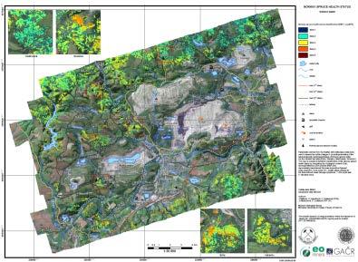
Change Detection Over Sokolov Open Pit Mine Areas, Czech Republic, Using Multi Temporal HyMAP Data ( )
") Change Detection Over Sokolov Open Pit Mine Areas, Czech Republic, Using Multi Temporal HyMAP Data (2009 2010) S. Adar* a G. Notesco b, A. Brook b, I. Livne b, P. Rojik c, V. Kopackova d, K. Zelenkova
Change Detection Over Sokolov Open Pit Mine Areas, Czech Republic, Using Multi Temporal HyMAP Data (2009 2010) S. Adar* a G. Notesco b, A. Brook b, I. Livne b, P. Rojik c, V. Kopackova d, K. Zelenkova
Geological information for Europe : Towards a pan-european Geological Data Infrastructure
 Geological information for Europe : Towards a pan-european Geological Data Infrastructure Integrating geoscientific information for EU competitiveness Co-funded by the European Union European societal
EU GeoCapacity. Assessing European Capacity for Geological Storage of Carbon Dioxide. Thomas Vangkilde-Pedersen, GEUS
 EU GeoCapacity Assessing European Capacity for Geological Storage of Carbon Dioxide Thomas Vangkilde-Pedersen, GEUS GeoCapacity results and the future for geological storage of CO 2 EU GeoCapacity open
Copernicus for Raw Materials Workshop
 Copernicus for Raw Materials Workshop Copernicus 40 User Years Forum Listening Industry Workshop, to the Beat 5th September of the Earth 2016, Brussels About http://copernicus.eu/raw-materials-workshop
A contribution to GEOSS from the SDI for Georesources in Africa
 A contribution to GEOSS from the SDI for Georesources in Africa A. TELLEZ-ARENAS BRGM, France in behalf of: Dr. Marc URVOIS Project Coordinator BRGM, France Mineral Resources Division INSPIRE Conference
EuroGeoSurveys An Introduction
 EGS -ASGMI Workshop, Madrid, 2015 EuroGeoSurveys An Introduction 40 Years Listening to the Beat of the Earth Click to edit Master title Albania style EuroGeoSurveys Austria Lithuania Luxembourg Belgium
OVERALL PROGRAMME. Sunday 16 October 2016:
 Sunday 16 October 2016: OVERALL PROGRAMME - Arrival in Morocco (landing either in Casablanca, with transfers to hotel to be organized by EGS, or Rabat) - Hosted dinner for the European Geological Surveys,
Spatially Enabled Society
 International Seminar on Land Administration Trends and Issues in Asia and the Pacific Region Spatially Enabled Society Abbas Rajabifard Vice Chair PCGIAP-WG3 Vice-President (President Elect), GSDI Association
GEO-CRADLE Project Meeting 2 Thursday, 17 th November, 2016
 GEO-CRADLE Project Meeting 2 Thursday, 17 th November, 2016 T4.3 EGS-PGI NRI Marek Graniczny (EGS PGI) Maria Przyłucka (EGS PGI) Eleftheria Poyiadji (EGS-IGME-Greece) Zbigniew Kowalski (EGS PGI) Christodoulos
Plan4all (econtentplus project)
") Plan4all (econtentplus project) Karel CHARVAT 1, Tomáš MILDORF 2 1 Help service remote sensing, Ltd., Černoleská 1600, 256 01 Benešov u Prahy, Czech Republic charvat@bnhelp.cz 2 Department of Mathematics
Plan4all (econtentplus project) Karel CHARVAT 1, Tomáš MILDORF 2 1 Help service remote sensing, Ltd., Černoleská 1600, 256 01 Benešov u Prahy, Czech Republic charvat@bnhelp.cz 2 Department of Mathematics
40 Years Listening to the Beat of the Earth
 EU-LA Mining & Exploration Convention Earth Observation in support of sustainable mining by the Geological Surveys of Europe Gerardo Herrera Veronika Kopačková Eleftheria Poyiadji Maria Przyłucka 40 Years
40 Years Listening to the Beat of the Earth
 EuroGeoSurveys The role of EuroGeoSurveys in Europe-Africa geoscientific cooperation 40 Years Listening to the Beat of the Earth EuroGeoSurveys 32 Albania Lithuania Austria Luxembourg Belgium The Netherlands
Evaluating Sustainability of the Georesources Observation System
 Evaluating Sustainability of the Georesources Observation System Michael Mente Federal Institute for Geosciences and Natural Resources Germany, Hannover GEOSS-CBC Meeting Athens April 27th 28th, 2009 GEOSS-CBC
LCA/RMF/MFA. Some elements
 LCA/RMF/MFA Some elements Position of the question The metals cycles The metals stocks > 4 Increased interlinkage of metals in products Stakes (cf. Raw Materials Initiative) > A method for mapping flows
EuroGeoSurveys & ASGMI The Geological Surveys of Europe and IberoAmerica
 EuroGeoSurveys & ASGMI The Geological Surveys of Europe and IberoAmerica Geological Surveys, what role? Legal mandate for data & information: Research Collection Management Interpretation/transformation
EuroGeoSource: sharing data and services on energy and mineral resources in Europe following INSPIRE
 EuroGeoSource: sharing data and services on energy and mineral resources in Europe following INSPIRE Rubén Béjar 1, Miguel Usón 2, Jesús Barrera 2, Rocío Recio 1, José M. Agudo 1, F. Javier Zarazaga-Soria
Model Generalisation in the Context of National Infrastructure for Spatial Information
 Model Generalisation in the Context of National Infrastructure for Spatial Information Tomas MILDORF and Vaclav CADA, Czech Republic Key words: NSDI, INSPIRE, model generalization, cadastre, spatial planning
GEOCHEMISTRY RESEARCH GROUP projects & research
 PATHWAY GEOCHEMISTRY RESEARCH GROUP projects & research MOROCCO-HUNGARY Bilateral Project Meknes 2012 GYOZO JORDAN Geochemistry Department, Hungarian Geological and Geophysical Institute RECEPTOR SOURCE
Access to MRM deposits in European countries and associated territories. Case Study: Aggregates plans and their future:
 WP6 Foresight study Access to MRM deposits in European countries and associated territories Case Study: Aggregates plans and their future: a view from South East Europe (SEE) countries Minerals4EU Final
Interoperability of Spatial Planning Data
 INSPIRE Conference 2010, Krakow, Poland Interoperability of Spatial Planning Data European Network of Best Practices for Interoperability of Spatial Planning Information Tomas Mildorf mildorf@centrum.cz
Project EuroGeoNames (EGN) Results of the econtentplus-funded period *
 Results of the econtentplus-funded period *") UNITED NATIONS Working Paper GROUP OF EXPERTS ON No. 33 GEOGRAPHICAL NAMES Twenty-fifth session Nairobi, 5 12 May 2009 Item 10 of the provisional agenda Activities relating to the Working Group on Toponymic
UNITED NATIONS Working Paper GROUP OF EXPERTS ON No. 33 GEOGRAPHICAL NAMES Twenty-fifth session Nairobi, 5 12 May 2009 Item 10 of the provisional agenda Activities relating to the Working Group on Toponymic
EXPERT ANALYSIS ON GEOGRAPHICAL SPECIFICITIES
 EXPERT ANALYSIS ON GEOGRAPHICAL SPECIFICITIES Mountains, Islands and Sparsely Populated Areas Dr. Gilda Carbone 9 Oct 2018 Objectives: to gather basic information from relevant programming documents (PAs,
Pilot applications for Greece and Egypt related end-users
 GEO-CRADLE Project Meeting 2 16 th November, 2016 Pilot applications for Greece and Egypt related end-users Panagiotis Kosmopoulos & Hesham El-Askary National Observatory of Athens Chapman University Eratosthenes
Space research. Horizon Work Programme. "Countdown to Horizon 2020 Space" Earth Observation topics. Brussels, 12 December 2013
 Space research Horizon 2020 - Work Programme "Countdown to Horizon 2020 Space" Earth Observation topics Brussels, 12 December 2013 richard.gilmore@ec.europa.eu Table of contents FP/Copernicus - general
Advancing Geoscientific Capability. Geological Survey of Finland
 Advancing Geoscientific Capability Geological Survey of Finland GTK in brief The Geological Survey of Finland (GTK) is one of the largest European centres of excellence in assessment, research and the
Use of geo-referenced data for DRM in Central Asia, problems and prospective
 Use of geo-referenced data for DRM in Central Asia, problems and prospective Dr. Akylbek Chymyrov Director, Kyrgyz Center of Geoinformation Systems Member of the Public Supervisory Board MES KR KSUCTA,
The future of SDIs. Ian Masser
 The future of SDIs Ian Masser Presentation Considers two questions relating to the future development of SDIs throughout the world Where have we got to now? Where should we go from here? Identifies four
Proposal for a DIRECTIVE OF THE EUROPEAN PARLIAMENT AND OF THE COUNCIL. establishing an infrastructure for spatial information in the Community
 Proposal for a DIRECTIVE OF THE EUROPEAN PARLIAMENT AND OF THE COUNCIL establishing an infrastructure for spatial information in the Community INSPIRE http://inspire.jrc.it/ Alessandro Annoni 1 EU Commission
Land Use and Land cover statistics (LUCAS)
") EUROPEAN COMMISSION EUROSTAT Directorate E: Sectoral and regional statistics Doc. ENV/DIMESA/7.1/2012 Original in EN Agenda point 7.1 Land Use and Land cover statistics (LUCAS) DIMESA Directors' Meeting
EUROPEAN COMMISSION EUROSTAT Directorate E: Sectoral and regional statistics Doc. ENV/DIMESA/7.1/2012 Original in EN Agenda point 7.1 Land Use and Land cover statistics (LUCAS) DIMESA Directors' Meeting
INSPIRing effort. Peter Parslow Ordnance Survey December Various European approaches to managing an SDI
 INSPIRing effort Peter Parslow Ordnance Survey December 2015 Various European approaches to managing an SDI WHAT IS INSPIRE? A European Union Directive A community effort: http://inspire.ec.europa.eu/
EMODne Entry Portal Steering Committee, Brussels, 16 December Alan Stevenson, Jonathan Lowndes (British Geological Survey) and the project team
 and the project team") EMODnet Geology EMODne Entry Portal Steering Committee, Brussels, 16 December 2013 Alan Stevenson, Jonathan Lowndes (British Geological Survey) and the project team Background 14 organisations participated
EMODnet Geology EMODne Entry Portal Steering Committee, Brussels, 16 December 2013 Alan Stevenson, Jonathan Lowndes (British Geological Survey) and the project team Background 14 organisations participated
Land Cover and Land Use Diversity Indicators in LUCAS 2009 data
 Land Cover and Land Use Diversity Indicators in LUCAS 2009 data A. Palmieri, L. Martino, P. Dominici and M. Kasanko Abstract Landscape diversity and changes are connected to land cover and land use. The
INSPIRE in Sweden.
 INSPIRE in Sweden Swedish National Data Service Established 2008. SND is a service organisation for Swedish research within the Humanities, Social Sciences and Medicine. SND is the Swedish node in an international
GSDI Global Spatial Data Infrastructure. Convergences between Geo Spatial Communities: key decision for decision making
 GSDI Global Spatial Data Infrastructure Convergences between Geo Spatial Communities: key decision for decision making April 14 th 2010 Bas Kok GSDI Past-President Director of International Affairs, Dutch
SPLAN-Natura Towards an integrated spatial planning approach for Natura th January, 2017 Brussels. Commissioned by DG Environment
 SPLAN-Natura 2000 Towards an integrated spatial planning approach for Natura 2000 Commissioned by DG Environment 17 th January, 2017 Brussels V. Simeonova (Ph.D.) Drivers towards integrating Biodiversity
Ministry of Health and Long-Term Care Geographic Information System (GIS) Strategy An Overview of the Strategy Implementation Plan November 2009
 Strategy An Overview of the Strategy Implementation Plan November 2009") Ministry of Health and Long-Term Care Geographic Information System (GIS) Strategy An Overview of the Strategy Implementation Plan November 2009 John Hill, Health Analytics Branch Health System Information
Ministry of Health and Long-Term Care Geographic Information System (GIS) Strategy An Overview of the Strategy Implementation Plan November 2009 John Hill, Health Analytics Branch Health System Information
EuroGeoSurveys. Minerals, metals and mining statistics: The role of Geological Surveys in building continental-scale official data sets
 EuroGeoSurveys Minerals, metals and mining statistics: The role of Geological Surveys in building continental-scale official data sets 40 Years Listening to the Beat of the Earth 1 EuroGeoSurveys 37 Geological
Aboriginal communities strengthen governance with location-based tools in the 21st century
 Aboriginal communities strengthen governance with location-based tools in the 21st century Today, Aboriginal communities are taking advantage of the geomatics technologies that underpin popular online
Supporting GPSC Cities with Satellite Earth Observation for Sustainable Urban Development
 Supporting GPSC Cities with Satellite Earth Observation for Sustainable Urban Development Global Platform for Sustainable Cities African Regional Workshop 14 May 2018 AfDB Headquarters Abidjan, Côte d'ivoire
Tomas Mildorf, Karel Janecka University of West Bohemia in Pilsen Czech Republic
 European Network of Best Practices for Interoperability of Spatial Planning Information Tomas Mildorf, Karel Janecka mildorf@centrum.cz, kjanecka@kma.zcu.cz University of West Bohemia in Pilsen Czech Republic
Spatial decision making in Armenia based on multidisciplinary environmental research
 EU FP7 EcoArm2ERA Integration into ERA Integration of spatial decision support systems and evidence based modeling in National/Regional Policy applications and regulatory systems: scientific and policy
EU BON Building the European Biodiversity Observation Network
 EU BON Building the European Biodiversity Observation Network Christoph L. Häuser christoph.haeuser@mfn-berlin.de Museum für Naturkunde - Leibniz Institute for Research on Evolution and Biodiversity Berlin,
Geographic information strategy
 Department for Environment, Food and Rural Affairs Geographic information strategy Methodology JULY 2011 2 Geographic information strategy Methodology This document provides a detailed description of the
EuroGEOSS Protected Areas Pilot
 EuroGEOSS Protected Areas Pilot Max Craglia European Commission Joint Research Centre Part 1: the present MyNatura2000 Mobile app. Awareness raising & volunteered data collection. Natura2000 covers 18%
Spatial Data Infrastructure in the Pacific
 Spatial Data Infrastructure in the Pacific. Sachindra Singh Senior Geospatial Systems Architect ICT for Development, Geoscience Division Pacific Community (SPC) OrganisationalBackground SPC - The Pacific
Geological Survey of Canada Lands and Minerals Sector Natural Resources Canada OneGeology, June 2018
 Geological Survey of Canada Lands and Minerals Sector Natural Resources Canada OneGeology, June 2018 Geological Survey of Canada Mission The Geological Survey of Canada provides public geoscience knowledge
The EuCheMS Division Chemistry and the Environment EuCheMS/DCE
 The EuCheMS Division Chemistry and the Environment EuCheMS/DCE EuCheMS Division on Chemistry and the Environment was formed as a FECS Working Party in 1977. Membership: 37 members from 34 countries. Countries
EuroGEOSS for Drought - Linking the European Drought Observatory to global and local scales
 EuroGEOSS for Drought - Linking the European Drought Observatory to global and local scales Barbara Hofer, Stefan Niemeyer, EC-JRC INSPIRE Conference 2010 Cracow June 24, 2010 Drought Relevance Droughts
Biodiversity and Ecosystem services Thinking globally, acting locally
 Biodiversity and Ecosystem services Thinking globally, acting locally Anne-Gaelle Ausseil - Manaaki Whenua Landcare Research Geoff Hicks National Commission for UNESCO 1 8 / 1 0 / 2 0 1 8 M A N A A K I
Earth Observation and GEOSS in Horizon Copernicus for Raw Material Workshop 5 th September 2016
 Earth Observation and GEOSS in Horizon 2020 Copernicus for Raw Material Workshop 5 th September 2016 Gilles OLLIER Head of Sector -Earth observation Directorate Environment Unit I.4 Climate Actions and
HYDERABAD STUDY CIRCLE CIVILS PRELIMS (GS) - TEST SERIES SCHEDULE Ancient India I
 - TEST SERIES SCHEDULE Ancient India I") HYDERABAD STUDY CIRCLE CIVILS PRELIMS (GS) - TEST SERIES SCHEDULE 2018 Date No. 24-02-2018-1 Geography - I India location, Size Structure and Physiography Drainage system + map Pointing (India) Ancient
HYDERABAD STUDY CIRCLE CIVILS PRELIMS (GS) - TEST SERIES SCHEDULE 2018 Date No. 24-02-2018-1 Geography - I India location, Size Structure and Physiography Drainage system + map Pointing (India) Ancient
What is OneGeology in 2015?
 What is OneGeology in 2015? 25th May 2015 Marko Komac OneGeology Managing Director Presentation Outline Background quick OneGeology history Consortium The vehicle to achieve the goal Current status Where
EUSAIR on sea topics from Slovenian perspective
 MINISTRY OF FOREIGN AFFAIRS REPUBLIC OF SLOVENIA EUSAIR on sea topics from Slovenian perspective Mag. Andreja Jerina National Coordinator 4 EU MRS: 270 millions of population 19 MS 12 non MS Sea basin
ACCESSIBILITY TO SERVICES IN REGIONS AND CITIES: MEASURES AND POLICIES NOTE FOR THE WPTI WORKSHOP, 18 JUNE 2013
 ACCESSIBILITY TO SERVICES IN REGIONS AND CITIES: MEASURES AND POLICIES NOTE FOR THE WPTI WORKSHOP, 18 JUNE 2013 1. Significant differences in the access to basic and advanced services, such as transport,
Improvements for Kosovo's spatial planning system / [presentation given in May 2011]
![Improvements for Kosovo's spatial planning system / [presentation given in May 2011]](/thumbs/95/122511393.jpg "Improvements for Kosovo's spatial planning system / [presentation given in May 2011]") Rochester Institute of Technology RIT Scholar Works Theses Thesis/Dissertation Collections 2011 Improvements for Kosovo's spatial planning system / [presentation given in May 2011] Luan Nushi Follow this
Rochester Institute of Technology RIT Scholar Works Theses Thesis/Dissertation Collections 2011 Improvements for Kosovo's spatial planning system / [presentation given in May 2011] Luan Nushi Follow this
Infrastructure for Spatial Information in Europe (INSPIRE)
") Infrastructure for Spatial Information in Europe (INSPIRE) 2011 GISCO Working Party 8-9.3.2012 INSPIRE is about improving access to spatial information: the environment doesn t stop at borders EU Geoportal
Infrastructure for Spatial Information in Europe (INSPIRE) 2011 GISCO Working Party 8-9.3.2012 INSPIRE is about improving access to spatial information: the environment doesn t stop at borders EU Geoportal
BIM and INSPIRE, for a better integration of built infrastructures in their environment : the MINnD project
 BIM and INSPIRE, for a better integration of built infrastructures in their environment : the MINnD project François ROBIDA Christophe CASTAING Strasbourg, > 1 8 septembre 2017 ABOUT BIM Building Information
Non-Governmental Organizations for Spatial Data Infrastructure. Environmental Democracy Case
 Non-Governmental Organizations for Spatial Data Infrastructure Environmental Democracy Case L.Jovičić, S.Vrečar, V.Cetl, K.Ristovski GSDI Small Grant Program Award 2011-2012 Non-Governmental Organisations
Group on Earth Observations (GEO) Cold Regions Work Plan Item WA-01-C3
 Cold Regions Work Plan Item WA-01-C3") EC Panel of Experts on Polar Observations, Research and Services Group on Earth Observations (GEO) Cold Regions Work Plan Item WA-01-C3 Barbara J. Ryan Secretariat Director Lanzhou, China 13 March 2013
EC Panel of Experts on Polar Observations, Research and Services Group on Earth Observations (GEO) Cold Regions Work Plan Item WA-01-C3 Barbara J. Ryan Secretariat Director Lanzhou, China 13 March 2013
Economic Benefit Study on Value of Spatial Information Australian Experience
 Economic Benefit Study on Value of Spatial Information Australian Experience Dr Zaffar Sadiq Mohamed-Ghouse Director, International Relations Cooperative Research Centre for Spatial Information zsadiq@crcsi.com.au
Alexia Tsouni National Observatory of Athens. Antwerp, 19/09/
 Coordinating and Integrating EO Activities in North Africa, Middle East, and Balkans. Accelerating the Development of Links with Geo/ Geoss/Copernicus and Inspire initiatives Alexia Tsouni National Observatory
Observation (EO) & Geomatics in Canada
 & Geomatics in Canada") Innovating to Increase the Impact of Earth Observation (EO) & Geomatics in Canada Natural Resources Canada February 25, 2014 Prashant Shukle, Director General Canada Centre for Mapping and Earth Observation
Innovating to Increase the Impact of Earth Observation (EO) & Geomatics in Canada Natural Resources Canada February 25, 2014 Prashant Shukle, Director General Canada Centre for Mapping and Earth Observation
Coastal data for Integrated Maritime Policies
 Coastal data for Integrated Maritime Policies LOCHET Corine Shom Name of presentation Protection against erosion and marine flood Name presenter Link between different data scales and Name of presentation
Pilot applications for Egypt related end-users
 GEO-CRADLE Regional Workshop Thursday, 25 th May, 2017 Pilot applications for Egypt related end-users Hesham El-Askary Chapman University Panagiotis Kosmopoulos National Observatory of Athens Stelios Kazadzis
INSPIRE Basics. Vlado Cetl European Commission Joint Research Centre. https://ec.europa.eu/jrc/
 INSPIRE Basics Vlado Cetl European Commission Joint Research Centre https://ec.europa.eu/jrc/ Serving society Stimulating innovation Supporting legislation Outline SDI? Why European SDI? INSPIRE Policy
WHO EpiData. A monthly summary of the epidemiological data on selected Vaccine preventable diseases in the WHO European Region
 A monthly summary of the epidemiological data on selected Vaccine preventable diseases in the WHO European Region Table 1: Reported cases for the period January December 2018 (data as of 01 February 2019)
INSPIRE General Introduction & Service Architecture
 INSPIRATION Spatial Data Infrastructure in the Western Balkans INSPIRE General Introduction & Service Architecture 1st National INSPIRATION Workshop Croatia November 21-22, 2012 A multi-countryprojectfunded
USGS Mineral Information Systems: Current Capabilities and Future Developments
 USGS Mineral Information Systems: Current Capabilities and Future Developments Dr. Steven M Fortier, Director National Minerals Information Center United States Geological Survey U.S. Department of the
A BRIEF INTRODUCTION TO COPERNICUS AND CAMS
 A BRIEF INTRODUCTION TO COPERNICUS AND CAMS Juan Garcés de Marcilla Director of Copernicus Services European Centre for Medium-Range Weather Forecasts Copernicus EU Copernicus EU Copernicus EU www.copernicus.eu
Bathymetry. EMODnet Stakeholder Conference & Sea-basin Workshops February Bathymetry
 EMODnet Stakeholder Conference & Sea-basin Workshops 14-15 February 2017 Arctic checkpoint Belinda Kater On behalf of all Checkpoints http://www.emodnet.eu 1 ? is the study of the "beds" or "floors" of
Addressing GEO-CRADLE regional challenges - Access to raw materials MINUTES
 Observation Activities in the regions of North Africa, Middle East, and Addressing GEO-CRADLE regional challenges - Access to raw materials MINUTES The GEO-CRADLE project has received funding from the
CountrySTAT REGIONAL BASIC ADMINISTRATOR TRAINING for GCC MEMBER STATES. CountrySTAT STATISTICS COMPONENT
 CountrySTAT REGIONAL BASIC ADMINISTRATOR TRAINING for GCC MEMBER STATES Abu Dhabi, United Arab Emirates (UAE), 26 30 January 2014 CountrySTAT STATISTICS COMPONENT (Concepts, Definitions, Classification,
16540/14 EE/cm 1 DG E 1A
 Council of the European Union Brussels, 5 December 2014 (OR. en) 16540/14 ENV 965 CULT 139 NOTE From: To: Subject: General Secretariat of the Council Delegations Charter of Rome on Natural and Cultural
Implementation of the ESPON 2020 cooperation program. 16 January 2017 Anneloes van Noordt
 Implementation of the ESPON 2020 cooperation program 16 January 2017 Anneloes van Noordt Outline! ESPON Cooperation Program! Specific Objectives! Applied Research! Targeted Analysis! Database & Tools!
European Natural Airborne Disaster Information and Coordination System for Aviation
 European Natural Airborne Disaster Information and Coordination System for Aviation Marcus Hirtl (ZAMG) + the EUNADICS-AV Team Background Eyjafjallajökull eruption April May 2010 Aviation is one of the
1. Baltic SCOPE Towards coherence and cross-border solutions in Baltic Maritime Spatial Plans
 NSHC 32th Conference Explanatory Note Dublin, Ireland Item E.2 MSP 21-23 June 2016 Germany Cross border MSP for the EEZ, a case study from the Baltic Sea The Federal Maritime and Hydrographic Agency of
Urban Integrated Services and Multi-Hazard Early Warning Systems
 WMO for UN New Urban Agenda Urban Integrated Services and Multi-Hazard Early Warning Systems Gregory R. Carmichael WMO WMO Priority: Urbanization - Research and services for megacities and large urban
Coastal Mapping Follow on? Bruno Frachon Corine Lochet Gaël Morvan
 Coastal Mapping Follow on? Bruno Frachon Corine Lochet Gaël Morvan Shared objectives; IHO DG MARE CPMR Development of a Joint European Coastal Mapping Programme (JECMaP) within the IHO EU network with
Applied Geoscience and Technology Division SOPAC. Joy Papao, Risk Information Systems Officer
 Joy Papao, Risk Information Systems Officer Secretariat of the Pacific Community SPC 22 Pacific Island States Head office in Noumea, New Caledonia 2 Regional offices (Pohnpei and Honiara) 600 staff 9 Technical
Trade Sustainability Impact Assessment in support of negotiations of a DCFTA between the EU and Egypt
 Trade Sustainability Impact Assessment in support of negotiations of a DCFTA between the EU and Egypt Annexes to the final Interim Technical Report Client: European Commission - DG TRADE Rotterdam, 30
CircUse News Special: The CircUse Compendium. This project is implemented through the CENTRAL EUROPE Programme co-financed by the ERDF
 CircUse News 9 2013 Special: This project is implemented through the CENTRAL EUROPE Programme co-financed by the ERDF 2 Newly published: Figure 1: Students in Trnava working on brownfield revitalisation.
Smart Cities and Urban Governance. The urbanapi Project: Bologna Case Study David C. Ludlow, Maria Paola Mauri, Chiara Caranti
 1 ABSTRACT Smart Cities and Urban Governance. The urbanapi Project: Bologna Case Study David C. Ludlow, Maria Paola Mauri, Chiara Caranti (David C. Ludlow, UWE University of the West of England, Bristol-
MALDIVES. Regional Expert Workshop On Land Accounting For SDG Monitoring & Reporting (25-27 th Sept 2017) - Fathimath Shanna, Aishath Aniya -
 - Fathimath Shanna, Aishath Aniya -") MALDIVES Regional Expert Workshop On Land Accounting For SDG Monitoring & Reporting (25-27 th Sept 2017) - Fathimath Shanna, Aishath Aniya - ABOUT MALDIVES Approximately 860 km long and 120 km wide Consists
MALDIVES Regional Expert Workshop On Land Accounting For SDG Monitoring & Reporting (25-27 th Sept 2017) - Fathimath Shanna, Aishath Aniya - ABOUT MALDIVES Approximately 860 km long and 120 km wide Consists
Green Space Services for Local Monitoring
 Green Space Services for Local Monitoring Aratos Group V3.0 2016/08 Value added services for the society using space and satellite technologies Aratos Group 2 One of the first European downstream value
Topic 4: Changing cities
 Topic 4: Changing cities Overview of urban patterns and processes 4.1 Urbanisation is a global process a. Contrasting trends in urbanisation over the last 50 years in different parts of the world (developed,
UNESCO s Earth Science. Education Initiative in Africa. United Nations Educational, Scientific and Cultural Organization
 UNESCO s Earth Science Education Initiative in Africa United Nations Educational, Scientific and Cultural Organization Few milestones First International Conference on African and Arabian Geoparks 2011,
Proposal on Knowledge Base Projects Sustainability
 Proposal on Knowledge Base Projects Sustainability MIN-GUIDE Policy Laboratory 5: Mining and Mineral Information in the European Union Slavko Solar, EuroGeoSurveys Madrid, May 23-25, 2018 40 Years Listening
Regulatory preparedness workshop Ispra, 5-6 October NANoREG Foresight (System) Platform. Christian Micheletti
 Platform. Christian Micheletti") Regulatory preparedness workshop Ispra, 5-6 October 2017 NANoREG Foresight (System) Platform Christian Micheletti Context: NANoREG project 2 A common European approach to the regulatory testing of Manufactured
Regulatory preparedness workshop Ispra, 5-6 October 2017 NANoREG Foresight (System) Platform Christian Micheletti Context: NANoREG project 2 A common European approach to the regulatory testing of Manufactured
Canada s opportunities
 Think Canada Opportunities in Canada s Resource Sector and Different Financing Instruments for Mining Projects December 11-12, 2013, Embassy of Canada, Dr. Bruno Wiest, Trade Commissioner (Science and
Fundamental Geospatial Data Themes
 Fundamental Geospatial Data Themes April 2016 Workshop Agenda Background why and how What is our objective? Fundamental data what are they? What are the candidate themes? Breakout Session Conclusion Background
Space Applications for Disaster Risk Reduction and Sustainable Development
 Space Applications for Disaster Risk Reduction and Sustainable Development Space Applications Section (SAS) ICT and Disaster Risk Reduction Division (IDD) UNESCAP Contents I. RESAP Activities 2016-2017
The Spatial Data Infrastructure for the Geological Reference of France
 The Spatial Data Infrastructure for the Geological Reference of France Marc Urvois, Thierry Baudin, Florence Cagnard, Philippe Calcagno, Nicolas Chauvin, Ulrich Clain, Santiago Gabillard, Sandrine Grataloup,
Call for Applications
 Call for Applications for a PanAfGeo Training «WP1 Geoscientific Mapping, part WP1E1 Remote Sensing» 20-30 November 2017, Bishoftu, Ethiopia in English 1. MAIN CONTEXT OF PANAFGEO PanAfGeo for Pan-African
Report. Workshop 5: How can atlases help to organise and promote the seas?
 Workshop 5: How can atlases help to organise and promote the seas? Report 1. Three key messages included on the reporting slide for the last plenary session Atlases help people to visualise intuitively
SUSTAINABLE GROWTH FROM GEOLOGY. gtk.fi
 SUSTAINABLE GROWTH FROM GEOLOGY gtk.fi Geological Survey of Finland The Geological Survey of Finland (GTK) is a leading European competence centre for the assessment and sustainable use of geological resources.