Alexia Tsouni National Observatory of Athens. Antwerp, 19/09/
|
|
|
- Asher Weaver
- 5 years ago
- Views:
Transcription


1 Coordinating and Integrating EO Activities in North Africa, Middle East, and Balkans. Accelerating the Development of Links with Geo/ Geoss/Copernicus and Inspire initiatives Alexia Tsouni National Observatory of Athens Antwerp, 19/09/2018


2 The continuous provision of accurate and timely information through coordinated and sustained Earth Observation together with INSPIRE data, Copernicus, and GCI information is a key enabler for informed decision making, in response to regional challenges and towards the achievement of the UN SDGs and the implementation of relevant EU Directives.


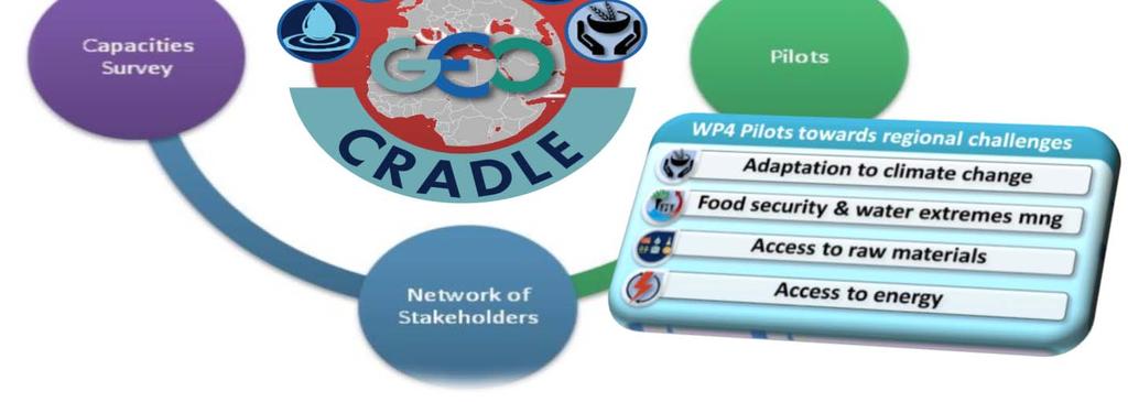
3 In this direction GEO-CRADLE coordinates and integrates state-of-the-art EO activities in the regions of North Africa, Middle East, and Balkans and develops links with GEO related initiatives towards GEOSS, contributing amongst others to: GEO-CRADLE brings together key players representing the entire EO value chain and promotes the uptake and exploitation of innovative EO activities in NAMEBA through: Cooperation Awareness raising Capacity building Open data sharing principles Interoperability
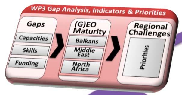
4 Challenges in GEO-CRADLE GEO-CRADLE is the only EU GEO funded CSA that runs over the diversified territories of North Africa, Middle East and Balkans (NAMEBA): Identifying common needs and regional priorities; Fostering the regional cooperation and integration of monitoring capabilities and skills, and facilitating the networking of stakeholders; Defining coordination and support actions that are beneficial from societal and market wise point of view, and also realistic and in line with the domestic priorities and user needs; Proposing/setting up large scale regional initiatives in Earth Observation (space based and in-situ) relating to capacity building and delivery of services and innovative information in the thematic areas of the project such as: Adaptation to Climate Change Improved Food Security Water Extremes Management Access to Raw Materials Access to Renewable Energy Resources - Solar Energy

 Improved")

 Access")
5 GEO-CRADLE Thematic Areas vs UN SDGs Adaptation to Climate Change (ACC) Improved Food Security Water Extremes Management (IFS-WEM) Access to Raw Materials (ARM) Access to Solar Energy (SENSE)


6 INSPIRE and Copernicus share key requirements. A key issue is alignment to achieve interoperability. Content and geometry need to be harmonized and connected.


7 GEO-CRADLE Outputs
8 GEO-CRADLE Regional Workshops 16 Regional Workshops have taken place so far in NAMEBA: advocating for free & open data policies in support of GEO & INSPIRE principles supporting knowledge sharing - capacity building providing participants with a unique crosssector networking opportunity (e.g. an enhanced cooperation between academia and industry) identifying the potential local challenges and needs that can be addressed by Earth Observation enhancing growth and innovation in the geo-information sector enabling more informed decision making DATE LOCATION 27/04/2016 Cairo, Egypt 14/07/2016 Novi Sad, Serbia 26/09/2016 Tirana, Albania 17-18/10/2016 Rabat, Morocco 19/10/2016 Timimoun, Algeria 16/11/2016 Limassol, Cyprus 03/01/2017 Chişinău, Moldova 02/02/2017 Abu Dhabi, United Arab Emirates 24/03/2017 Sofia, Bulgaria 26/04/2017 Brussels, Belgium (Industrial market) 09/05/2017 Magurele, Romania 25/05/2017 Cairo, Egypt 14/09/2017 Tel Aviv, Israel 07/12/2017 Tunis, Tunisia 15-16/03/2018 Istanbul, Turkey 04-05/06/2018 Thessaloniki, Greece (3 rd South- Eastern Europe GEO Workshop)

9
10 GEO-CRADLE Portal

11 GEO-CRADLE Networking Platform Available for the first time in the RoI: inventory of regional capacities profiles of stakeholders assessment of country maturity potential partnerships
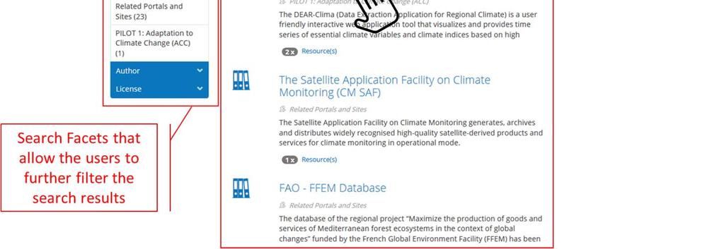
12 Software: Wordpress. GEO-CRADLE Networking Platform Access: Open access to all. Profiles: The profiles include exclusive and specific information collected by the GEO-CRADLE Survey. Validation: The profiles are validated by an administrator before publishing. Filtering / search: Three different mechanisms for filtering / search: Map search: 3 filters to search the database & displays results on the map; Keywords search: search by one or more keywords; Advanced search page: 10 filters combined with search by keywords option.


13 Search option 1: Map view


14 Filters: Country: Greece Thematic Area: Food security Results on the map: 14
15 Search option 2: Search by keywords (for quick search)

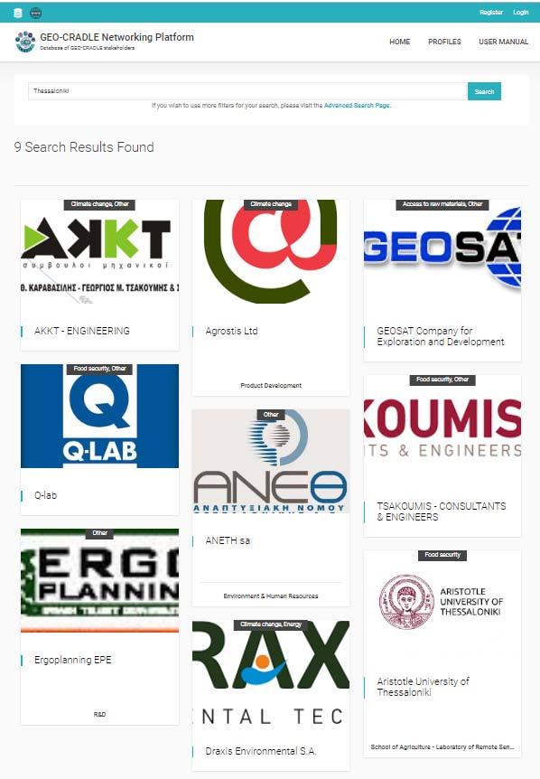
16 Filters: Keywords: Thessaloniki Results: 9

17 Search option 3: Advanced search page
18


19 Filters: Region: Balkans Τhematic area: Climate change Role: Raw data/provider Results: 27

20 Example Profile: National Observatory of Athens Sections: Description Details Activity Focus Capacities National Activities Engagement in GEO-CRADLE Location
21 GEO-CRADLE Portal


22 National / regional portals

23 GEO-CRADLE Regional DataHub Stable service and full interoperability with GCI and GEO DAB APIs, as well as connection with data available through the project pilots.
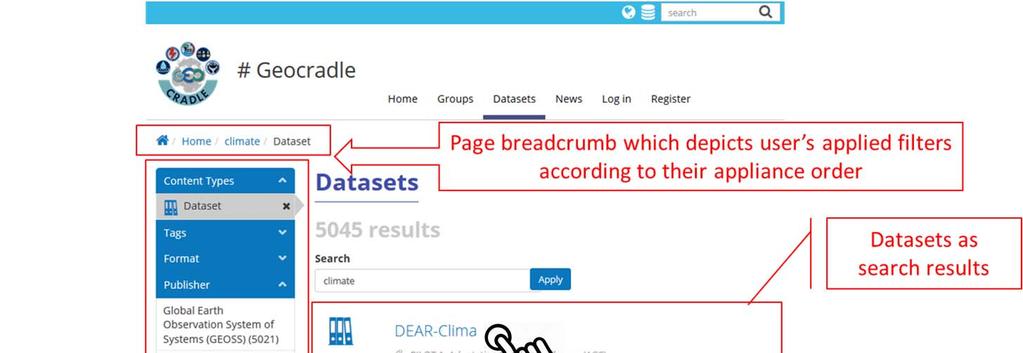
24 The GEO-CRADLE RDH is designed and operates as the focal node in the region in the context of GEOSS and Copernicus implementation. It is an open data web management tool / portal (developed using web technologies such as PHP, HTML5, JavaScript, CSS, etc.) that provides access to region-related datasets and services, directly fed from GCI, and at the same time being the central gateway for regional data providers to contribute easily and timely their products to GEOSS. It advances the current state of the art by integrating DKAN, which is a complementary implementation of CKAN (Comprehensive Knowledge Archive Network) over Drupal/PHP, with the GEO DAB APIs. DKAN CMS (Content Management System) is an open-source data management platform that treats data as content, facilitating the subsequent publication, management, and maintenance of these, no matter the administration team, its size and level of technical expertise.
25 Several achievements were accomplished for the RDH to be able to provide its users the functionalities described above: - Search in multiple sources (although by default DKAN looks up for datasets and resources in a single local database). - Search for datasets in remote resources (integration of the GEO DAB APIs in the DKAN environment). - Display the remote datasets and resources on-the-fly and with high performance (using a rendering cache mechanism which also implements an Adaptive Time-to-Live consistency mechanism to periodically check the consistency of the cached rendering structures with the original data to assure that users do not receive stale data). - Cleaning data mechanism (cleans identical or duplicate data, discovers missing information for data, discovers URL that have changed or that are not working anymore, discards data with invalid URL schemes, etc.) - Preview mechanism (to preview data of various formats and services, such as CSV files, Web Map Services, Zip files, etc.) An integrated Search and Display mechanism that offers the users unified, centralized and user-friendly interface.
26 Search examples
27

28


29 DATA Regions of Interest Balkans Middle East North Africa Thematic Areas Climate Change Food Security & Water Extremes Raw Materials Energy EO Data Categories Space borne Ground based Modelling GEO-CRADLE DATA PROVIDERS GEO-CRADLE Survey 10 national portals and sites National portals in total: 42 Desk Research 32 national portals and sites 12 continental and global portals and sites GEOSS Portal datasets


30 Data Providers Adaptation to Climate Change Improved Food Security and Water Mgt Better access to Raw Materials National sites and portals in numbers Better access to Energy Balkans Middle East North Africa Total number of portals and sites: 42
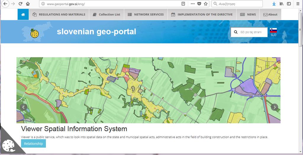
31 a/a Portals Prioritised Portals 1. Danube Reference Data and Services Infrastructure (DRDSI) Brokered by GEOSS 2. Eusoils 3. Albania GEOportal Pending 4. Montenegro GEOportal Pending 5. Croatia GEOportal Pending 6. Moldova National geospatial data of Moldova 7. FYROM Soil information system Pending 8. Bosnia & Herzegovina GEOportal Pending 9. REP of SRPSKA GEOportal Pending 10. Slovenia Portal and Forest Data Viewer 11. Cyprus Geoportal 12. Cyprus Air quality 13. United Arabic Emirates Abu Dhabi Geospatial Portal and Map Viewer Pending 14. Poland Central geological Db Pending


32 Danube Reference Data Portal harvested through the GCRDH


33 INSPIREcompliant example
34

35 GEO-CRADLE Portal
 Adaptation to")
 Access to Raw Materials 4) Access to Solar Energy FREE AND OPEN")
36 GEO-CRADLE Pilots 1) Adaptation to Climate Change 2) Improved Food Security Water Extremes Management 3) Access to Raw Materials 4) Access to Solar Energy FREE AND OPEN ACCESS TO ALL PILOTS DATASETS AND SERVICES


37 Pilot 1: Adaptation to Climate Change DEAR-Clima

38 Pilot 1: Adaptation to Climate Change DEAR-Clima

39 Pilot 1: Adaptation to Climate Change DEAR-Clima


40 Pilot 1: Adaptation to Climate Change Desert Dust

41 Pilot 1: Adaptation to Climate Change Select date Desert Dust

42 Pilot 1: Adaptation to Climate Change Desert Dust Aerosol optical depth by AERONET sun-photometer


43 Pilot 1: Adaptation to Climate Change Desert Dust Cloud and aerosol properties


44 Pilot 1: Adaptation to Climate Change Desert Dust Horizontal and vertical dust forecasts with satellite assimilation


45 Pilot 1: Adaptation to Climate Change Desert Dust Aerosol Classification by the PollyXT Lidar


46 Pilot 2: Improved Food Security Water Extremes Management MyDewetra Click on FREE ENTRANCE and hit Dewetra on the left pane to enter the main platform


47 Pilot 2: Improved Food Security Water Extremes Management MyDewetra

48 Pilot 2: Improved Food Security Water Extremes Management MyDewetra STATIC Layer contains data that does not change frequently, needed to design a comprehensive risk scenario such as the exposures or the hazard maps.

49 Pilot 2: Improved Food Security Water Extremes Management MyDewetra Balkans 25y Flood Hazard Press L to get the legend
")
50 Pilot 2: Improved Food Security Water Extremes Management MyDewetra OBSERVATION Layer Soil Samples SOIL ANALYSIS Click on soil analysis Zoom to a region containing soil samples (e.g. North Eastern Greece)


51 Pilot 2: Improved Food Security Water Extremes Management MyDewetra Click on a point and visualize the spectrum / chemical results (which can be downloaded)

52 Pilot 2: Improved Food Security Water Extremes Management Regional Soil Spectral Library


53 Pilot 3: Access to Raw Materials EGDI is EuroGeoSurveys European Geological Data Infrastructure


54 Pilot 3: Access to Raw Materials
 calculated from Sentinel-2 image from 2017.")
/((NIR+RED)), where individual components correspond to")
55 Pilot 3: Access to Raw Materials Normalized difference vegetation index (NDVI) calculated from Sentinel-2 image from The index was caluclated based on the formula: ((NIR-RED)/((NIR+RED)), where individual components correspond to the spectral band of the satellite.
 based on Landsat-8 image and")
56 Pilot 3: Access to Raw Materials Lineament map extracted from 5 different techniques (DEM, Directional Filters, Principal Component Analysis, False Color Composite and Rationing) based on Landsat-8 image and SRTM.


57 Pilot 4: Access to Solar Energy Solar Atlas of Egypt


58 Pilot 4: Access to Solar Energy Solar Atlas of Greece


59 Pilot 4: Access to Solar Energy PRETECT


60 Pilot 4: Access to Solar Energy PAR Atlas for Greece, Cyprus, Egypt


61 Pilot 4: Access to Solar Energy SOLEA The exploitation of EO data through GEO activities and SENSE will provide access to advanced solar energy related products, in support to large scale solar farm projects, grid operators, national and private electrical transmission and handling entities, so as to guarantee the uninterrupted energy flow and the power grid stability.


, in support of the 3 GEOSS priorities, namelycc, DRR and")
62 GEO-CRADLE upgrade in GEO: Project -> Community Activity -> Initiative GEO Capacity Building in North Africa, Middle East, Balkans, and Black Sea A continuation and extension of the work of the GEO CRADLE which will capitalise, sustain and scale-up its results, as well as key outcomes of other relevant EU flagship projects and initiatives (e.g. GEOGLAM, NextGEOSS, ERAPLANET, EuroGEOSS, AfriGEOSS, GEO-VENER, EO4SDG), in support of the 3 GEOSS priorities, namelycc, DRR and SDGs. Geographic extension Thematic extension Operational Maturity
63 GEO-CRADLE network engaged in EUROGEOSS: Expressions of Intent No Theme Action Group 1 Reinforcing Common Agriculture Policy Agriculture/Food 2 Disaster Resilience Showcase under H2020 call 3 NextGEOSS Enhanced landslide risk assessment framework Disaster Resilience 4 Earth Observation for Disaster-Resilient Societies 5 Earth Observation for SOLar energy and applications Energy 6 Earth Observation for Epidemics of Vector-borne Diseases Climate


64
Pilot applications for Greece and Egypt related end-users
 GEO-CRADLE Project Meeting 2 16 th November, 2016 Pilot applications for Greece and Egypt related end-users Panagiotis Kosmopoulos & Hesham El-Askary National Observatory of Athens Chapman University Eratosthenes
Earth Observation and GEOSS in Horizon Copernicus for Raw Material Workshop 5 th September 2016
 Earth Observation and GEOSS in Horizon 2020 Copernicus for Raw Material Workshop 5 th September 2016 Gilles OLLIER Head of Sector -Earth observation Directorate Environment Unit I.4 Climate Actions and
EuroGEOSS Protected Areas Pilot
 EuroGEOSS Protected Areas Pilot Max Craglia European Commission Joint Research Centre Part 1: the present MyNatura2000 Mobile app. Awareness raising & volunteered data collection. Natura2000 covers 18%
GEO-CRADLE - μία πλατφόρμα συλλογής δεδομένων Παρατήρησης της Γης, στις περιοχές των Βαλκανίων, της Βορείου Αφρικής και της Μέσης Ανατολής
 GEO-CRADLE - μία πλατφόρμα συλλογής δεδομένων Παρατήρησης της Γης, στις περιοχές των Βαλκανίων, της Βορείου Αφρικής και της Μέσης Ανατολής Dr. Evangelos Gerasopoulos Director of the Greek GEO Office National
Pilot applications for Egypt related end-users
 GEO-CRADLE Regional Workshop Thursday, 25 th May, 2017 Pilot applications for Egypt related end-users Hesham El-Askary Chapman University Panagiotis Kosmopoulos National Observatory of Athens Stelios Kazadzis
Geological information for Europe : Towards a pan-european Geological Data Infrastructure
 Geological information for Europe : Towards a pan-european Geological Data Infrastructure Integrating geoscientific information for EU competitiveness Co-funded by the European Union European societal
Realizing benefits of Spatial Data Infrastructure A user s perspective from Environment Agency - Abu Dhabi
 Realizing benefits of Spatial Data Infrastructure A user s perspective from Environment Agency - Abu Dhabi Anil Kumar Director, Environment Information Management 26 April 2012 Geospatial World Forum,
Report on the establishment of UN GGIM: Europe Item 14. 4th session of the Committee of Experts on UN-GGIM
 Report on the establishment of UN GGIM: Europe Item 14 1 Why regional European committees of UN GGIM? In the ECOSOC resolution 2011/24 on the UN GGIM: Emphasizes the importance of promoting national, regional
Observation (EO) & Geomatics in Canada
 & Geomatics in Canada") Innovating to Increase the Impact of Earth Observation (EO) & Geomatics in Canada Natural Resources Canada February 25, 2014 Prashant Shukle, Director General Canada Centre for Mapping and Earth Observation
Innovating to Increase the Impact of Earth Observation (EO) & Geomatics in Canada Natural Resources Canada February 25, 2014 Prashant Shukle, Director General Canada Centre for Mapping and Earth Observation
EU collaborations with NASA LCLUC Program & Current Priorities
 & Current Priorities ioannis Manakos, Dr. Centre for Research and Technology Hellas Information Technologies Institute Visual Analytics, Virtual & Augmented Reality Laboratory European Association of Remote
GEO-CRADLE: Fostering regional cooperation and roadmap for GEO and Copernicus implementation in N. Africa, Middle East, and the Balkans
 BEYOND, The European EO Center of Excellence in N. Africa, Middle East, Balkans (BAMENA) GEO-CRADLE: Funded under H2020 - Climate action, environment, resource efficiency and raw materials ACTIVITY: Developing
Introduction of the Asia-Oceania Global Earth Observation System of Systems (AOGEOSS) GEO Initiative(GI-22 )
 GEO Initiative(GI-22 )") Introduction of the Asia-Oceania Global Earth Observation System of Systems (AOGEOSS) GEO Initiative(GI-22 ) Prof. Xiang ZHOU Institute of Remote Sensing and Digital Earth, CAS 11 May 2017 Kunming, China
Introduction of the Asia-Oceania Global Earth Observation System of Systems (AOGEOSS) GEO Initiative(GI-22 ) Prof. Xiang ZHOU Institute of Remote Sensing and Digital Earth, CAS 11 May 2017 Kunming, China
EuroGEOSS for Drought - Linking the European Drought Observatory to global and local scales
 EuroGEOSS for Drought - Linking the European Drought Observatory to global and local scales Barbara Hofer, Stefan Niemeyer, EC-JRC INSPIRE Conference 2010 Cracow June 24, 2010 Drought Relevance Droughts
Copernicus Data Driven Services for Regional & Local Government in Greece
 Workshop on Copernicus uptake by public authorities Gabriel Mavrellis CEO, Geospatial Enabling Technologies Copernicus Data Driven Services for Regional & Local Government in Greece The Company Copernicus
C o p e r n i c u s a n d W I G O S
 C o p e r n i c u s a n d W I G O S Jean-Noël Thépaut & Mark Dowell 24 October 2017 GEO XIV, Washington DC, 23-28 October 2017 T h e C o p e r n i c u s P r o g r a m m e Copernicus is the European Union
Concept note. High-Level Seminar: Accelerating Sustainable Energy for All in Landlocked Developing Countries through Innovative Partnerships
 Concept note High-Level Seminar: Accelerating Sustainable Energy for All in Landlocked Developing Countries through Innovative Partnerships Date: 24 and 25 October 2016 Venue: Conference Room C3, Vienna
Building Institutional Capacity for Multi-Hazard Early Warning in Pacific Countries Subtitle
 Building Institutional Capacity for Multi-Hazard Early Warning in Pacific Countries Subtitle Title Keran Wang Chief, Space Applications Section ICT and Disaster Risk Reduction Division 30 March 2018 Slide
EuroGeoSurveys An Introduction
 EGS -ASGMI Workshop, Madrid, 2015 EuroGeoSurveys An Introduction 40 Years Listening to the Beat of the Earth Click to edit Master title Albania style EuroGeoSurveys Austria Lithuania Luxembourg Belgium
Collaborative Systems for the Creation of Marine Services
 Collaborative Systems for the Creation of Marine Services INSPIRE 2016 Nuno Almeida Nuno Catarino Barcelona, 28 th September 2016 Elecnor Deimos is a trademark which encompasses Elecnor Group companies
Addressing GEO-CRADLE regional challenges - Access to raw materials MINUTES
 Observation Activities in the regions of North Africa, Middle East, and Addressing GEO-CRADLE regional challenges - Access to raw materials MINUTES The GEO-CRADLE project has received funding from the
Building Institutional Capacity for Multi-Hazard Early Warning in Asia and the Pacific Subtitle
 Building Institutional Capacity for Multi-Hazard Early Warning in Asia and the Pacific Subtitle Title Keran Wang Chief, Space Applications Section ICT and Disaster Risk Reduction Division 22 May 2018 Pillar
Norwegian spatial data infrastructure supporting disaster risk management Norwegian Mapping Authority
 Norwegian spatial data infrastructure supporting disaster risk management Norwegian Mapping Authority Arvid Lillethun, Norwegian Mapping Authority Land and Poverty 2018 Conference, World Bank 19.-23. March
Spatial data interoperability and INSPIRE compliance the platform approach BAGIS
 Spatial data interoperability and INSPIRE compliance the platform approach BAGIS BAGIS Voluntary, independent, public, non-profit organization; Organization with main mission to promote the growth of the
EO Information Services. Assessing Vulnerability in the metropolitan area of Rio de Janeiro (Floods & Landslides) Project
 Project") EO Information Services in support of Assessing Vulnerability in the metropolitan area of Rio de Janeiro (Floods & Landslides) Project Ricardo Armas, Critical Software SA Haris Kontoes, ISARS NOA World
EO Information Services in support of Assessing Vulnerability in the metropolitan area of Rio de Janeiro (Floods & Landslides) Project Ricardo Armas, Critical Software SA Haris Kontoes, ISARS NOA World
Cristina Ananasso Copernicus Unit DG GROW. H2020 Space: Calls on Earth Observation and Copernicus Ilan Ramon Conference 28/01/2018 Tel Aviv
 Cristina Ananasso Copernicus Unit DG GROW H2020 Space: Calls on Earth Observation and Copernicus Ilan Ramon Conference 28/01/2018 Tel Aviv OUTLINE Call Space 2018-2020 - Earth Observation and Copernicus
UN GGIM and National SDI Strategy
 MSDI Open Forum on 26 th January 2016 Contributing to the successful delivery of MSDI UN GGIM and National SDI Strategy Hiroshi Murakami Deputy Administrator Geospatial Information Authority of Japan Geospatial
FAO GAEZ Data Portal
 FAO GAEZ Data Portal www.fao.org/nr/gaez Renato Cumani Environment Officer Land and Water Division Natural Resources Management and Environment Department Food and Agriculture Organization of the UN October
OSS MISSION.
 GEO-CRADLE COORDINATING AND INTEGRATING STATE-OF-THE-ART EARTH OBSERVATION ACTIVITIES IN THE REGION OF NORTH OF AFRICA, MIDDLE EAST, AND BALKANS AND DEVELOPING LINKS WITH GEO RELATED INITIATIVES TOWARD
Geographic Information Infrastructure and Policy Framework for Sustainable Mountain Development in the Hindu Kush-Himalayas
 Geo SMART ASIA 2017 22-24 August, Kualalampur Geographic Information Infrastructure and Policy Framework for Sustainable Mountain Development in the Hindu Kush-Himalayas Basanta Shrestha, Director Strategic
40 Years Listening to the Beat of the Earth
 EuroGeoSurveys The role of EuroGeoSurveys in Europe-Africa geoscientific cooperation 40 Years Listening to the Beat of the Earth EuroGeoSurveys 32 Albania Lithuania Austria Luxembourg Belgium The Netherlands
Adaptation to Climate Change in other Mountain Regions
 Adaptation to Climate Change in other Mountain Regions First Working Group of the Carpathian Convention on Adaptation to Climate Change Brussels, 4-5 February 2012 Pictures: A. Czaderna, A.& D. Nowak,
Introduction. Elevation Data Strategy. Status and Next Steps
 1 2 Introduction Elevation Data Strategy Status and Next Steps 3 Canada is the 2nd largest country in the world - 9.9 million sq km Surrounded by 3 oceans with 202 000 km of coastline Population over 35
WMO Priorities and Perspectives on IPWG
 WMO Priorities and Perspectives on IPWG Stephan Bojinski WMO Space Programme IPWG-6, São José dos Campos, Brazil, 15-19 October 2012 1. Introduction to WMO Extended Abstract The World Meteorological Organization
A donor partner view. Olaf Magnus Østensen. 'Modernization of spatial data infrastructure to reduce risks and impacts of floods'
 A donor partner view Olaf Magnus Østensen 'Modernization of spatial data infrastructure to reduce risks and impacts of floods' About the EEA Grants programme http://eeagrants.org/ Beneficiary country Donor
40 Years Listening to the Beat of the Earth
 EU-LA Mining & Exploration Convention Earth Observation in support of sustainable mining by the Geological Surveys of Europe Gerardo Herrera Veronika Kopačková Eleftheria Poyiadji Maria Przyłucka 40 Years
CLICK HERE TO KNOW MORE
 CLICK HERE TO KNOW MORE Geoinformatics Applications in Land Resources Management G.P. Obi Reddy National Bureau of Soil Survey & Land Use Planning Indian Council of Agricultural Research Amravati Road,
Proposal for a DIRECTIVE OF THE EUROPEAN PARLIAMENT AND OF THE COUNCIL. establishing an infrastructure for spatial information in the Community
 Proposal for a DIRECTIVE OF THE EUROPEAN PARLIAMENT AND OF THE COUNCIL establishing an infrastructure for spatial information in the Community INSPIRE http://inspire.jrc.it/ Alessandro Annoni 1 EU Commission
African requirements for SDI standardization Antony Cooper Operating Unit Fellow Built Environment CSIR PO Box 395, Pretoria, 0001, South Africa
 ISO/TC 211 workshop on spatial data infrastructures (SDIs) African requirements for SDI standardization Antony Cooper Operating Unit Fellow Built Environment CSIR PO Box 395, Pretoria, 0001, South Africa
Harmonizing spatial databases and services at local and regional level
 Harmonizing spatial databases and services at local and regional level A. Ionita 1, M. Caian 2, V. Vassilev 3, V. Craciunescu 2, I. Nedelcu 4 1 Research Institute for Artificial Intelligence, Bucuresti,
GIS Building Communities beyond National Borders (Building Successful Spatial Data Infrastructures) Nick Land, ESRI Europe
 Nick Land, ESRI Europe") GIS Building Communities beyond National Borders (Building Successful Spatial Data Infrastructures) Nick Land, ESRI Europe UK worst flooding in the last 60 years 350,000 households without drinking water
GIS Building Communities beyond National Borders (Building Successful Spatial Data Infrastructures) Nick Land, ESRI Europe UK worst flooding in the last 60 years 350,000 households without drinking water
EO-MINERS and Minerals 4EU
 GEO-CRADLE pre-kick-off Meeting Friday, 18 th of February, 2016 Veronika Kopačková, Czech Geological Survey EO-MINERS and Minerals 4EU IONIC Centre, 11 Lysiou Street Athens, Greece EO-MINERS (2010-2013)
INDONESIA S S UPDATE: GEOSPATIAL INFORMATION FOR SUSTAINABLE DEVELOPMENT RELATED TO INA SDI Dr. Asep Karsidi, M.Sc
 INDONESIA S S UPDATE: GEOSPATIAL INFORMATION FOR SUSTAINABLE DEVELOPMENT RELATED TO INA SDI Dr. Asep Karsidi, M.Sc GEOSPATIAL INFORMATION AGENCY 08 August, 2012 OUTLINE 1. Transformation Bakosurtanal into
Working Group on Geospatial Information
 GEO-XIV Plenary Summary Working Group on Geospatial Information 4 th Meeting Lawrence Friedl Argyro Kavvada Group on Earth Observations NASA Earth Science Dec. 6-8, 2017 An intergovernmental organization
Web Portal to European Soil Database
 Web Portal to European Soil Database A step towards harmonization of Soil Information in Europe Marc Van Liedekerke, Panos Panagos, Jean Dusart Soils Portal: http://eusoils.jrc.it Data The European Soil
ArcGIS for INSPIRE. Marten Hogeweg
 ArcGIS for INSPIRE Marten Hogeweg Please Take Our Survey on the App Download the Esri Events app and find your event Select the session you attended Scroll down to find the feedback section Complete answers
Economic and Social Council
 United Nations Economic and Social Council Distr.: General 2 July 2012 E/C.20/2012/10/Add.1 Original: English Committee of Experts on Global Geospatial Information Management Second session New York, 13-15
Supporting GPSC Cities with Satellite Earth Observation for Sustainable Urban Development
 Supporting GPSC Cities with Satellite Earth Observation for Sustainable Urban Development Global Platform for Sustainable Cities African Regional Workshop 14 May 2018 AfDB Headquarters Abidjan, Côte d'ivoire
Status of implementation of the INSPIRE Directive 2016 Country Fiches. COUNTRY FICHE Netherlands
 Status of implementation of the INSPIRE Directive 2016 Country Fiches COUNTRY FICHE Netherlands Introduction... 1 1. State of Play... 2 1.1 Coordination... 2 1.2 Functioning and coordination of the infrastructure...
Challenges and Successes in Sharing Geospatial Data in Africa
 Challenges and Successes in Sharing Geospatial Data in Africa 2018 GeoNode Summit Torino, Italy March 26-28, 2018 Bernard Justus Muhwezi Manager, Geo-Information Services Uganda Bureau of Statistics, Kampala,
Adding value to Copernicus services with member states reference data
 www.eurogeographics.org Adding value to Copernicus services with member states reference data Neil Sutherland neil.sutherland@os.uk GIS in the EU 10 November 2016 Copyright 2016 EuroGeographics 61 member
EO4SEE - THE PATHFINDER OF OPERATIONAL SATELLITE MONITORING FOR THE REGION OF THE BLACK SEA AND CENTRAL EUROPE
 EO4SEE: Pathfinder assessment for regional high volume data access, processing and information service delivery platforms - South East Region EO4SEE - THE PATHFINDER OF OPERATIONAL SATELLITE MONITORING
Climate Change. Climate Change Service
 Service The C3S m ission To support European adaptation and mitigation policies by: Providing consistent and authoritative information about climate Building on existing capabilities and infrastructures
The ESPON Programme and the use of spatial data on the European level
 The ESPON Programme and the use of spatial data on the European level Plan4Business project ISOCARP Brussels Liaison Office 29 November 2013 Marjan van Herwijnen Project Expert - ESPON Coordination Unit
GEO Geohazards Community of Practice
 GEO Geohazards Community of Practice 1) Co-Chair of GHCP With input from: Stuart Marsh, GHCP Co-Chair Francesco Gaetani, GEO Secretariat and many GHCP contributors 1) Nevada Bureau of Mines and Geology
Land Use in the context of sustainable, smart and inclusive growth
 Land Use in the context of sustainable, smart and inclusive growth François Salgé Ministry of sustainable development France facilitator EUROGI vice president AFIGéO board member 1 Introduction e-content+
NSDI as a tool for Secure land tenure
 NSDI as a tool for Secure land tenure General Overview To look at the progress in SDI development and its application in policy formulation and impact on land tenure. INTEGRATION OF INFORMATION POLICIES
Geospatial Policy Development and Institutional Arrangements *
 HIGH LEVEL FORUM ON GLOBAL GEOSPATIAL MANAGEMENT INFORMATION WORKING PAPER No. 13 First Forum Seoul, Republic of Korea, 24-26 October 2011 Geospatial Policy Development and Institutional Arrangements *
Spatially Enabled Society
 International Seminar on Land Administration Trends and Issues in Asia and the Pacific Region Spatially Enabled Society Abbas Rajabifard Vice Chair PCGIAP-WG3 Vice-President (President Elect), GSDI Association
Global Geospatial Information Management Country Report Finland. Submitted by Director General Jarmo Ratia, National Land Survey
 Global Geospatial Information Management Country Report Finland Submitted by Director General Jarmo Ratia, National Land Survey Global Geospatial Information Management Country Report Finland Background
GENERAL RECOMMENDATIONS. Session 7. Breakout discussion. discuss on regional and interregional. proposals 1. COLLABORATION BETWEEN PROGRAMMES
 Session 7 24 July 2016, 9.00-11.00 Breakout discussion on regional and interregional joint project proposals Mr Shahbaz Khan summarized the two days of presentations and exchanges and requested the participants
EuroGeoSurveys & ASGMI The Geological Surveys of Europe and IberoAmerica
 EuroGeoSurveys & ASGMI The Geological Surveys of Europe and IberoAmerica Geological Surveys, what role? Legal mandate for data & information: Research Collection Management Interpretation/transformation
World Meteorological Organization
 World Meteorological Organization Opportunities and Challenges for Development of Weather-based Insurance and Derivatives Markets in Developing Countries By Maryam Golnaraghi, Ph.D. Head of WMO Disaster
The Process of Spatial Data Harmonization in Italy. Geom. Paola Ronzino
 The Process of Spatial Data Harmonization in Italy Geom. Paola Ronzino ISSUES Geospatial Information in Europe: lack of data harmonization the lack of data duplication of data CHALLENGES Challenge of INSPIRE:
Urban Integrated Services and Multi-Hazard Early Warning Systems
 WMO for UN New Urban Agenda Urban Integrated Services and Multi-Hazard Early Warning Systems Gregory R. Carmichael WMO WMO Priority: Urbanization - Research and services for megacities and large urban
a national geological survey perspective François ROBIDA BRGM (French Geological Survey)
") a national geological survey perspective François ROBIDA BRGM (French Geological Survey) Pre-Conference Seminar on Socio-Economic Value of Geospatial for National and Regional Development 21 August 2017,
a national geological survey perspective François ROBIDA BRGM (French Geological Survey) Pre-Conference Seminar on Socio-Economic Value of Geospatial for National and Regional Development 21 August 2017,
Urban areas & climate change
 Urban areas & climate change Paolo Gamba University of Pavia University of Pavia The UNIPV TLC & RS Lab is a dynamic research group developing in the past years many techniques devoted to the analysis
Tomas Mildorf New technologies for the information society University of west bohemia in pilsen, Czech republic
 Tomas Mildorf New technologies for the information society University of west bohemia in pilsen, Czech republic Karel Charvat Help Service Remote Sensing, Czech republic AIP-7 GEOSS, 20 MAY 2014 By 2015,
Spatial Data Infrastructure Concepts and Components. Douglas Nebert U.S. Federal Geographic Data Committee Secretariat
 Spatial Data Infrastructure Concepts and Components Douglas Nebert U.S. Federal Geographic Data Committee Secretariat August 2009 What is a Spatial Data Infrastructure (SDI)? The SDI provides a basis for
Status of implementation of the INSPIRE Directive 2016 Country Fiches. COUNTRY FICHE Malta
 Status of implementation of the INSPIRE Directive 2016 Country Fiches COUNTRY FICHE Malta Introduction... 1 1. State of Play... 2 1.1 Coordination... 2 1.2 Functioning and coordination of the infrastructure...
Space research. Horizon Work Programme. "Countdown to Horizon 2020 Space" Earth Observation topics. Brussels, 12 December 2013
 Space research Horizon 2020 - Work Programme "Countdown to Horizon 2020 Space" Earth Observation topics Brussels, 12 December 2013 richard.gilmore@ec.europa.eu Table of contents FP/Copernicus - general
Open Data meets Big Data
 Open Data meets Big Data Max Craglia, Sven Schade, Anders Friis European Commission Joint Research Centre www.jrc.ec.europa.eu Serving society Stimulating innovation Supporting legislation JRC is Technical
A state of the art and user driven Copernicus service Physics and Biogeochemistry
 C M E M S P r e s e n t a n d F u t u r e R e q u i r e m e n t s f o r I n - S i t u a n d S a t e l l i t e O b s e r v a t i o n s Antonio REPPUCCI; Pierre Yves LE TRAON Mercator Ocean International
Weather Climate Science to Service Partnership South Africa
 PROJECTS UNDERWAY Title of the Weather Climate Science to Service Partnership South Africa Together, building on an existing strong partnership, South African Weather Service and the Met Office will build
Ministry of ICT of I.R.IRAN
 The ECO 8/6 mill km 2 10 Slamic countries ~330 mill people Oil, Gas, Industries,Tourism 2 Issue transformation in last decade Problem solving needs more integrated approach More interaction &complexity
Project Progress and Achievements
 IPA PROJECT BUILDING RESILIENCE TO DISASTERS IN WESTERN BALKANS AND TURKEY Project Progress and Achievements 15 16 April 2014 Meeting on enhancing hydrological data management and exchange procedures in
Plan4all (econtentplus project)
") Plan4all (econtentplus project) Karel CHARVAT 1, Tomáš MILDORF 2 1 Help service remote sensing, Ltd., Černoleská 1600, 256 01 Benešov u Prahy, Czech Republic charvat@bnhelp.cz 2 Department of Mathematics
Plan4all (econtentplus project) Karel CHARVAT 1, Tomáš MILDORF 2 1 Help service remote sensing, Ltd., Černoleská 1600, 256 01 Benešov u Prahy, Czech Republic charvat@bnhelp.cz 2 Department of Mathematics
Liana Talaue McManus. Division of Marine Affairs and Policy Rosenstiel School of Marine & Atmospheric Science University of Miami
 Liana Talaue McManus Division of Marine Affairs and Policy Rosenstiel School of Marine & Atmospheric Science University of Miami Outline 1. Coasts as vulnerable & resilient social ecological systems 2.
Introduction of Remote Sensing Methods for Monitoring the Under Restoration Amiantos Mine, Cyprus
 Sixth International Conference on Remote Sensing and Geoinformation of Environment, 26-29 March, 2018 - Cyprus Introduction of Remote Sensing Methods for Monitoring the Under Restoration Amiantos Mine,
THE ROLE OF GEOSPATIAL AT THE WORLD BANK
 THE ROLE OF GEOSPATIAL AT THE WORLD BANK INSPIRE Conference Barcelona, Spain September 26, 2016 Kathrine Kelm Senior Land Administration Specialist Global Land and Geospatial Unit The World Bank Group
EXPECTATIONS OF TURKISH ENVIRONMENTAL SECTOR FROM INSPIRE
 EXPECTATIONS OF TURKISH ENVIRONMENTAL SECTOR FROM INSPIRE June, 2010 Ahmet ÇİVİ Tuncay DEMİR INSPIRE in the Eyes of MoEF Handling of Geodata by MoEF Benefits Expected TEIEN First Steps for INSPIRE Final
Demonstration of a local SDI solution with several stakeholders in pilot areas in line with EU best practices
 EU Twinning project for the Agency of Land Relations and Cadaster (ALRC)- Organization, Streamlining and Computerization Process in Mapping in the Republic of Moldova. Demonstration of a local SDI solution
SDG s and the role of Earth Observation
 SDG s and the role of Earth Observation Christian Heipke IPI - Institute for Photogrammetry and GeoInformation Leibniz Universität Hannover Germany Secretary General, ISPRS 1. No Poverty 2. Zero Hunger
Regional EGM on Community of Practice of Georeferenced Information System. for Disaster Risk Management (Geo-DRM) April 2014, Bangkok, Thailand
 April 2014, Bangkok, Thailand") Regional EGM on Community of Practice of Georeferenced Information System for Disaster Risk Management (Geo-DRM) 23-25 April 2014, Bangkok, Thailand Presented By Mukesh Kumar Keshari Ministry of Home Affairs
Regional EGM on Community of Practice of Georeferenced Information System for Disaster Risk Management (Geo-DRM) 23-25 April 2014, Bangkok, Thailand Presented By Mukesh Kumar Keshari Ministry of Home Affairs
Seasonal Forecast for the area of the east Mediterranean, Products and Perspectives
 Seasonal Forecast for the area of the east Mediterranean, Products and Perspectives Dr Kleanthis Nicolaides Senior Meteorological Officer Department of Meteorology The need for weather forecasts from where
INSPIRE Basics. Vlado Cetl European Commission Joint Research Centre. https://ec.europa.eu/jrc/
 INSPIRE Basics Vlado Cetl European Commission Joint Research Centre https://ec.europa.eu/jrc/ Serving society Stimulating innovation Supporting legislation Outline SDI? Why European SDI? INSPIRE Policy
Manual of Digital Earth
 V8.0 March 27, 2018 International Society for Digital Earth Manual of Digital Earth (Tentative Title) OUTLINE Foreword Chapter 1 Understanding Digital Earth 1.1 Origins and Precursors of Digital Earth
The Global Statistical Geospatial Framework and the Global Fundamental Geospatial Themes
 The Global Statistical Geospatial Framework and the Global Fundamental Geospatial Themes Sub-regional workshop on integration of administrative data, big data and geospatial information for the compilation
ACTION PLAN FOR WORLD HERITAGE IN LATIN AMERICA AND THE CARIBBEAN ( )
") Annex ACTION PLAN FOR WORLD HERITAGE IN LATIN AMERICA AND THE CARIBBEAN (2014-2024) The current Regional Action Plan for Latin America and the Caribbean for 2014-2024 has been elaborated by the State Parties
Annex ACTION PLAN FOR WORLD HERITAGE IN LATIN AMERICA AND THE CARIBBEAN (2014-2024) The current Regional Action Plan for Latin America and the Caribbean for 2014-2024 has been elaborated by the State Parties
WMO activities for the first year of project implementation
 BUILDING RESILIENCE TO DISASTERS IN WESTERN BALKANS AND TURKEY WMO activities for the first year of project implementation 2 nd Steering Committee Meeting Sari Lappi Project Coordinator WMO/FMI Project
[Mediterranean Climate Outlook Forum] Status Report (Survey)
![[Mediterranean Climate Outlook Forum] Status Report (Survey)](/thumbs/83/87049025.jpg "[Mediterranean Climate Outlook Forum] Status Report (Survey)") [Mediterranean Climate Outlook Forum] Status Report (Survey) Annotated Outline Specific Climate features of concerned region The salient features of the seasonal climate of the region (rainy season, dry
[Mediterranean Climate Outlook Forum] Status Report (Survey) Annotated Outline Specific Climate features of concerned region The salient features of the seasonal climate of the region (rainy season, dry
The Joint Programming Initiative on Cultural Heritage (JPICH): European perspective
: European perspective") COPERNICUS FOR CULTURAL HERITAGE Copernicus User Forum Industry Workshop Brussels, 24 April 2017 The Joint Programming Initiative on Cultural Heritage (JPICH): European perspective Cristina Sabbioni CNR,
COPERNICUS FOR CULTURAL HERITAGE Copernicus User Forum Industry Workshop Brussels, 24 April 2017 The Joint Programming Initiative on Cultural Heritage (JPICH): European perspective Cristina Sabbioni CNR,
Emerging issues to use geospatial initiatives in the societal context of disaster managing **
 ADVANCE UNEDITED VERSION UNITED NATIONS E/CONF.103/3/Add.1 ECONOMIC AND SOCIAL COUNCIL Tenth United Nations Regional Cartographic Conference for the Americas New York, 19-23, August 2013 Item 6 (a) of
TheEuropean Location Framework
 TheEuropean Location Framework Presentation to: Author: Date: TN-ITS/INSPIRE session at INSPIRE Conference Olaf Magnus Østensen, ELF co-ordinator 18 June2014 The ELF project 15 national mapping authorities
Status of implementation of the INSPIRE Directive 2016 Country Fiches. COUNTRY FICHE Estonia
 Status of implementation of the INSPIRE Directive 2016 Country Fiches COUNTRY FICHE Estonia Introduction... 1 1. State of Play... 2 1.1 Coordination... 2 1.2 Functioning and coordination of the infrastructure...
GEOMATICS. Shaping our world. A company of
 GEOMATICS Shaping our world A company of OUR EXPERTISE Geomatics Geomatics plays a mayor role in hydropower, land and water resources, urban development, transport & mobility, renewable energy, and infrastructure
Update on INSPIRE; interoperable framework for natural hazards
 Update on INSPIRE; interoperable framework for natural hazards Robert Tomas EC-DG Joint Research Centre 16 th Meeting of Working Group F on Floods 2014, Rome www.jrc.ec.europa.eu Serving society Stimulating
Compact guides GISCO. Geographic information system of the Commission
 Compact guides GISCO Geographic information system of the Commission What is GISCO? GISCO, the Geographic Information System of the COmmission, is a permanent service of Eurostat that fulfils the requirements
HARMONIZATION OF SEISMIC HAZARD MAPS FOR THE WESTERN BALKAN COUNTRIES : Overview of main BSHAP results
 Zagreb, Croatia Hotel Sheraton 12-13 May 2011 NATO SfP Project no. 983054 HARMONIZATION OF SEISMIC HAZARD MAPS FOR THE WESTERN BALKAN COUNTRIES : Overview of main BSHAP results Prof. Branislav Glavatović,
Copernicus Relays. Roles and responsibilities of the Copernicus Relays. user uptake
 Copernicus Relays user uptake Roles and responsibilities of the Copernicus Relays The European Commission has launched two Networks, the Copernicus Relays and the Copernicus Academy, to contribute to spreading
International and regional network status
 WORLD METEOROLOGICAL ORGANIZATION JOINT MEETING OF CBS EXPERT TEAM ON SURFACE-BASED REMOTELY- SENSED OBSERVATIONS (Second Session) AND CIMO EXPERT TEAM ON OPERATIONAL REMOTE SENSING (First Session) CBS/ET-SBRSO-2