Collaborative Systems for the Creation of Marine Services
|
|
|
- Bonnie Stanley
- 5 years ago
- Views:
Transcription


.")
1 Collaborative Systems for the Creation of Marine Services INSPIRE 2016 Nuno Almeida Nuno Catarino Barcelona, 28 th September 2016 Elecnor Deimos is a trademark which encompasses Elecnor Group companies that deal with Technology and Information Systems: Deimos Space S.L.U., Deimos Imaging S.L.U., Deimos Castilla La Mancha S.L., Deimos Engenharia S.A., Deimos Space UK Ltd., Deimos Space S.r.L. (Romania). DME-DQS-SUPSC03-PRE-14-E DEIMOS Engenharia S.A. 1
2 Overview Company Presentation Big Data Systems for EO DEIMOS and Copernicus Key Requirements Experience and Lessons Learned INSPIRE Use of Copernicus Data Application on Other Sectors DME-DQS-SUPSC03-PRE-14-E DEIMOS Engenharia S.A. 2


3 Company Presentation DEIMOS Engenharia belongs to the Elecnor DEIMOS group Located in Lisbon, Portugal since 2002 Staff of 40 Engineers Areas of Expertise Earth Observation Systems and Applications Guidance Navigation and Control Ground Segment Systems Satellite Navigation DME-DQS-SUPSC03-PRE-14-E DEIMOS Engenharia S.A. 3
4 DEIMOS and EO Big Data Systems Past and on-going projects related to EO Systems: More than 70 partners involved, including national and international companies, research centers and SMEs EO Support Systems: Prime/Coordinator System Integrator System and Tools Development Provision of EO Data Access Processing facilities for Big Data Support Services Addressing major barriers to growth Integration and EO development Value Added Services Development DME-DQS-SUPSC03-PRE-14-E DEIMOS Engenharia S.A. 4


5 Big Data Projects Timeline DME-DQS-SUPSC03-PRE-14-E DEIMOS Engenharia S.A. 5


6 SenSyF: Sentinel Synergy Framework DEIMOS first project in Big Data Setup of: Big Data Access to GMES/Copernicus Cloud Processing Application Integration Support Seven pilot services to test the system Designed to facilitate the exploitation of Sentinel data DME-DQS-SUPSC03-PRE-14-E DEIMOS Engenharia S.A. 6


7 Co-ReSyF: Coastal Waters Research Synergy Framework Easy to use system for coastal waters researchers to process data and share results resyf.eu DME-DQS-SUPSC03-PRE-14-E DEIMOS Engenharia S.A. 7


8 NextGEOSS Federated access for EO data, including user friendly tools for data mining, discovery, access and exploitation. Deliver the next generation data hub and Earth Observation exploitation for innovation and business Engage communities, promoting innovative GEOSS powered applications from Europe Advocate GEOSS as a sustainable European approach for Earth Observation data distribution and exploitation Duration of 3.5 Years Budget: 10 M 27 Partners KO in Dec DME-DQS-SUPSC03-PRE-14-E DEIMOS Engenharia S.A. 8


9 SIMOcean: System for the Integrated Monitoring of the Ocean Wide Variety of Data Sources Cloud Computing Capabilities for Data Fusion User Communities DME-DQS-SUPSC03-PRE-14-E DEIMOS Engenharia S.A.


10 DEMONSTRATION SERVICES FISHING AREAS CHARACTERIZATION Prediction of fish distributions and potential areas of catch for the main species along the Portuguese coast SEA STATE INDEX FOR HABOUR APPROACHES To provide access to real time sea state information based on highresolution forecast models for the port authorities. DIAGNOSTIC OF METEO OCEANOGRAPHIC FIELDS Integrated web visualization environment of different meteooceanographic fields coming from satellite, models and in situ over the Portuguese Continental Shelf DME-DQS-SUPSC03-PRE-14-E DEIMOS Engenharia S.A.
11 SIMOcean: System for the Integrated Monitoring of the Ocean Compliant with INSPIRE by using the metadata profile from An on-going project to develop a Geoportal to facilitate access to information about the Portuguese marine environment. Coordinated by the Portuguese Authorities Services use data from Copernicus CMEMS provides Ocean Color and Sea Surface Temperature on a daily basis Catalogue will be shared with other National entities POSTER #43 in Poster Session 15:30 17:30 DME-DQS-SUPSC03-PRE-14-E DEIMOS Engenharia S.A. 11


12 ONGOING PROJECTS AND COPERNICUS Copernicus Space Segment Copernicus Core Services COLLABORATION IS KEY DME-DQS-SUPSC03-PRE-14-E DEIMOS Engenharia S.A. 12
13 KEY REQUIREMENTS Data Access Providing mechanisms to quickly discover, access and manage data regardless the formats Collaboration Environment where people can share information and reproduce analysis Flexibility Able to support the development and integration of value added services Performance Supporting parallel computing techniques and bringing the processing as close to the data as possible DME-DQS-SUPSC03-PRE-14-E DEIMOS Engenharia S.A. 13


14 REFERENCES OGC Open standards for the global geospatial community to work with Geographic information INSPIRE European Directive for the creation of a EU Spatial Data Infrastructure By providing legislation, rules and guidelines in several domains Metadata, Data Products, Infrastructure, Data Sharing, Spatial Data Services, Monitoring and Reporting OPEN DATA Data that anyone can access, use and share. Promote the Data Sharing Promote the Commercial Exploitation of Data Through the development of Value Added products DME-DQS-SUPSC03-PRE-14-E DEIMOS Engenharia S.A. 14
 defined Commercial data providers usually have independent data delivery processes Usually the actual")
15 EXPERIENCE AND LESSONS LEARNED Data Discovery and Retrieval Data not catalogued or accessible through standard interfaces Complicated and time-consuming registration processes Sometimes with specific tools to discover and download the data Unreliable network connections Metadata not (well) defined Commercial data providers usually have independent data delivery processes Usually the actual products have good quality DME-DQS-SUPSC03-PRE-14-E DEIMOS Engenharia S.A. 15

16 EXPERIENCE AND LESSONS LEARNED Data Sharing (Open Data + INSPIRE) Structured and Reliable Approach to Share the Data Clear Guidelines Provided by EC (Open Data Gold book and INSPIRE) Reduced Cost in Information Exchange Everything is Machine Readable Format Compliant with INSPIRE Promote the Exploitation of Data Through the development of Value Added products Will be extensively explored in NextGEOSS DME-DQS-SUPSC03-PRE-14-E DEIMOS Engenharia S.A. 16
17 EXPERIENCE AND LESSONS LEARNED INSPIRE Key directive to share geographic information across Europe Reliable and accessible support tools Metadata editors, validators, others... Continuous and agile evolution of the directive Considering the increasing number of Geographic Services Remove entry barriers Specially important for private sector Through support material (tutorials, documentation, training) Important to have success stories DME-DQS-SUPSC03-PRE-14-E DEIMOS Engenharia S.A. 17
18 INTEGRATION OF COPERNICUS DATA Data Discovery Simple tools to discover data With standard intefaces to facilitate integration with other services Data Access Multiple data retrieval channels Simple authentication mechanisms Support Reliable data products Well documented Adequate infrastrcure Helpdesk DME-DQS-SUPSC03-PRE-14-E DEIMOS Engenharia S.A. 18
19 APPLICATION ON DIFFERENT SECTORS For the Engagement of Other Sectors: We think that the concept BringProcessingtotheData istheway forward Needs to be available an asbtraction layer to remove the technological barrier. Strong commitement in communication and dissemination activities To increase the collaboration with companies and institutes (nonspace) Fund the users directly for the take-up of Copernicus data based services H2020 SPACE and other calls are key DME-DQS-SUPSC03-PRE-14-E DEIMOS Engenharia S.A. 19

20 APPLICATION ON DIFFERENT SECTOR Co-ReSyF: Competitive Call and Summer School Call open now: DME-DQS-SUPSC03-PRE-14-E DEIMOS Engenharia S.A. 20
21 Thank You Elecnor Deimos is a trademark which encompasses Elecnor Group companies that deal with Technology and Information Systems: Deimos Space S.L.U., Deimos Imaging S.L.U., Deimos Castilla La Mancha S.L., Deimos Engenharia S.A., Deimos Space UK Ltd., Deimos Space S.r.L. (Romania). DME-DQS-SUPSC03-PRE-14-E DEIMOS Engenharia S.A.
22 DEIMOS and EO Big Data Systems EO Big Data Access and Processing Copernicus Sentinels and other EO data Cloud processing for Big Data system Integration of tools and services Ongoing projects Provision of EO Data Access Addressing major barriers to growth Processing facilities for Big Data Support services to integration and EO development DME-DQS-SUPSC03-PRE-14-E DEIMOS Engenharia S.A. 22
23 SIMOcean: System for the Integrated Monitoring of the Ocean Aims to contribute for the improvement of the National marine management, monitoring and vigilance capabilities Data Sources: Earth Observation Meteorological Data Maritime Environmental Monitoring Data Data will be available on a Cloud Environment For the development and exploitation of new Services DME-DQS-SUPSC03-PRE-14-E DEIMOS Engenharia S.A. 23

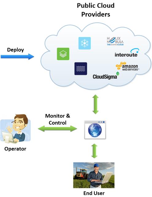
24 GENERAL ARCHITECTURE DME-DQS-SUPSC03-PRE-14-E DEIMOS Engenharia S.A. 24
DEIMOS FOREIGN DIRECT INVESTMENT CASE IN UK
 DEIMOS FOREIGN DIRECT INVESTMENT CASE IN UK UK SPACE CONFERENCE EXPANDING FRONTIERS MAY 2017 Ismael López Deputy CEO @ElecnorDeimos All Rights Reserved No part of this document may be reproduced, stored,
C o p e r n i c u s M a r i n e S e r v i c e i n s u p p o r t t o s u s t a i n a b l e B l u e G r o w t h
 Implemented by C o p e r n i c u s M a r i n e S e r v i c e i n s u p p o r t t o s u s t a i n a b l e B l u e G r o w t h European Commission, DG MARE 19 Januray 2018 C O P E R N I C U S I N B R I E
P r o d u c t p o r t f o l i o a n d d a t a a c c e s s
 P r o d u c t p o r t f o l i o a n d d a t a a c c e s s Copernicus Environment Service Copernicus EU Copernicus EU Copernicus EU www.copernicus.eu I N T R O D U C T I O N O F U S E C A S E User Uptake
C o p e r n i c u s a n d W I G O S
 C o p e r n i c u s a n d W I G O S Jean-Noël Thépaut & Mark Dowell 24 October 2017 GEO XIV, Washington DC, 23-28 October 2017 T h e C o p e r n i c u s P r o g r a m m e Copernicus is the European Union
INSPIREd solutions for Air Quality problems Alexander Kotsev
 INSPIREd solutions for Air Quality problems Alexander Kotsev www.jrc.ec.europa.eu Serving society Stimulating innovation Supporting legislation The European data puzzle The European data puzzle 24 official
The Global Statistical Geospatial Framework and the Global Fundamental Geospatial Themes
 The Global Statistical Geospatial Framework and the Global Fundamental Geospatial Themes Sub-regional workshop on integration of administrative data, big data and geospatial information for the compilation
Ocean meets Regions conference Committee of the Regions, Brussels 21 November 2017 Cecilia Donati. Marine Monitoring.
 Implemented by C o p e r n i c u s M a r i n e S e r v i c e : a E u r o p e a n t o o l i n s u p p o r t o f P u b l i c A d m i n i s t r a t i o n f o r a s u s t a i n a b l e B l u e G r o w t h
GIS Building Communities beyond National Borders (Building Successful Spatial Data Infrastructures) Nick Land, ESRI Europe
 Nick Land, ESRI Europe") GIS Building Communities beyond National Borders (Building Successful Spatial Data Infrastructures) Nick Land, ESRI Europe UK worst flooding in the last 60 years 350,000 households without drinking water
GIS Building Communities beyond National Borders (Building Successful Spatial Data Infrastructures) Nick Land, ESRI Europe UK worst flooding in the last 60 years 350,000 households without drinking water
Earth Observation and GEOSS in Horizon Copernicus for Raw Material Workshop 5 th September 2016
 Earth Observation and GEOSS in Horizon 2020 Copernicus for Raw Material Workshop 5 th September 2016 Gilles OLLIER Head of Sector -Earth observation Directorate Environment Unit I.4 Climate Actions and
Tomas Mildorf New technologies for the information society University of west bohemia in pilsen, Czech republic
 Tomas Mildorf New technologies for the information society University of west bohemia in pilsen, Czech republic Karel Charvat Help Service Remote Sensing, Czech republic AIP-7 GEOSS, 20 MAY 2014 By 2015,
ArcGIS for INSPIRE. Marten Hogeweg Satish Sankaran
 ArcGIS for INSPIRE Marten Hogeweg Satish Sankaran Outline What is ArcGIS ArcGIS for INSPIRE Web GIS Case Studies Roadmap Q&A What is INSPIRE? INSPIRE is the legal framework for a European Spatial Data
The Canadian Ceoscience Knowledge Network. - A Collaborative Effort for Unified Access to Ceoscience Data
 The Canadian Ceoscience Knowledge Network - A Collaborative Effort for Unified Access to Ceoscience Data The Canadian Geoscience Knowledge Network A Collaborative Effort for Unified Access to Geoscience
Proposal for a DIRECTIVE OF THE EUROPEAN PARLIAMENT AND OF THE COUNCIL. establishing an infrastructure for spatial information in the Community
 Proposal for a DIRECTIVE OF THE EUROPEAN PARLIAMENT AND OF THE COUNCIL establishing an infrastructure for spatial information in the Community INSPIRE http://inspire.jrc.it/ Alessandro Annoni 1 EU Commission
ArcGIS for INSPIRE. Marten Hogeweg
 ArcGIS for INSPIRE Marten Hogeweg Please Take Our Survey on the App Download the Esri Events app and find your event Select the session you attended Scroll down to find the feedback section Complete answers
Implementation of Inspire in Denmark - How we get it flying! Olav Eggers National Survey & Cadastre -Denmark
 Implementation of Inspire in Denmark - How we get it flying! Olav Eggers oe@kms.dk National Survey & Cadastre -Denmark Introduction Overview Infrastructure for Spatial Information Act National Survey and
U s i n g t h e E S A / E U M E T C A S T N a v i g a t o r s
 U s i n g t h e E S A / E U M E T C A S T N a v i g a t o r s Copernicus User Uptake Information Sessions Copernicus EU Copernicus EU Copernicus EU www.copernicus.eu I N T R O D U C T I O N O F U S E C
EXPECTATIONS OF TURKISH ENVIRONMENTAL SECTOR FROM INSPIRE
 EXPECTATIONS OF TURKISH ENVIRONMENTAL SECTOR FROM INSPIRE June, 2010 Ahmet ÇİVİ Tuncay DEMİR INSPIRE in the Eyes of MoEF Handling of Geodata by MoEF Benefits Expected TEIEN First Steps for INSPIRE Final
econtentplus GS Soil
 econtentplus GS Soil General aims Assessment and strategic development of INSPIRE compliant Geodata-Services for European Soil Data BPN on basis of the EU 2007/2/EC (INSPIRE) Directive for Annex III theme
The Process of Spatial Data Harmonization in Italy. Geom. Paola Ronzino
 The Process of Spatial Data Harmonization in Italy Geom. Paola Ronzino ISSUES Geospatial Information in Europe: lack of data harmonization the lack of data duplication of data CHALLENGES Challenge of INSPIRE:
Network of European Regions Using Space Technologies
 NEREUS Network of European Regions Using Space Technologies Core mission NEREUS WHAT IS SPACE ABOUT??? Spreading use of space technologies at regional level Stimulating the development of space applications
Ministry of Health and Long-Term Care Geographic Information System (GIS) Strategy An Overview of the Strategy Implementation Plan November 2009
 Strategy An Overview of the Strategy Implementation Plan November 2009") Ministry of Health and Long-Term Care Geographic Information System (GIS) Strategy An Overview of the Strategy Implementation Plan November 2009 John Hill, Health Analytics Branch Health System Information
Ministry of Health and Long-Term Care Geographic Information System (GIS) Strategy An Overview of the Strategy Implementation Plan November 2009 John Hill, Health Analytics Branch Health System Information
MARINE SPATIAL PLANNING & MARINE CADASTRE: CHALLENGES AND ISSUES
 MARINE SPATIAL PLANNING & MARINE CADASTRE: CHALLENGES AND ISSUES Roger Longhorn Secretary General, GSDI Association rlonghorn@gsdi.org Member, IHO Marine SDI Working Group ral@alum.mit.edu Member, UNESCO
Ready for INSPIRE.... connecting worlds. European SDI Service Center
 Ready for INSPIRE Consultancy SOFTWARE T r a i n i n g Solutions... connecting worlds European SDI Service Center Increasing Added Value with INSPIRE and SDI Components INSPIRE In 2007, the European Commission
Swedish Spatial Data Infrastructure and the National Geodata Strategy
 Submitted to the United Nations Committee of Experts on Global Geospatial Information Management Seventh Session New York, August 2018 Registration number 519-2018/4327 Country Report, Sweden Swedish Spatial
Open spatial data infrastructure
 Open spatial data infrastructure a backbone for digital government Thorben Hansen Geomatikkdagene 2018 Stavanger 13.-15. mars Spatial Data Infrastructure definition the technology, policies, standards,
Copernicus Relays. Roles and responsibilities of the Copernicus Relays. user uptake
 Copernicus Relays user uptake Roles and responsibilities of the Copernicus Relays The European Commission has launched two Networks, the Copernicus Relays and the Copernicus Academy, to contribute to spreading
Relevant INSPIRE clusters/themes
 Relevant INSPIRE clusters/themes Marine and Atmosphere Cluster (III-13) Atmospheric conditions (AC) Ozone, composition (SO2, CH4, CO2), aerosols (III-14) Meteorological geographical features (MF) Temperature,
Copernicus Data Driven Services for Regional & Local Government in Greece
 Workshop on Copernicus uptake by public authorities Gabriel Mavrellis CEO, Geospatial Enabling Technologies Copernicus Data Driven Services for Regional & Local Government in Greece The Company Copernicus
Adding value to Copernicus services with member states reference data
 www.eurogeographics.org Adding value to Copernicus services with member states reference data Neil Sutherland neil.sutherland@os.uk GIS in the EU 10 November 2016 Copyright 2016 EuroGeographics 61 member
The Swedish National Geodata Strategy and the Geodata Project
 The Swedish National Geodata Strategy and the Geodata Project Ewa Rannestig, Head of NSDI Co-ordination Unit, Lantmäteriet, ewa.rannstig@lm.se Ulf Sandgren, Project Manager Geodata Project, Lantmäteriet,
EU collaborations with NASA LCLUC Program & Current Priorities
 & Current Priorities ioannis Manakos, Dr. Centre for Research and Technology Hellas Information Technologies Institute Visual Analytics, Virtual & Augmented Reality Laboratory European Association of Remote
Tomas Mildorf, Karel Janecka University of West Bohemia in Pilsen Czech Republic
 European Network of Best Practices for Interoperability of Spatial Planning Information Tomas Mildorf, Karel Janecka mildorf@centrum.cz, kjanecka@kma.zcu.cz University of West Bohemia in Pilsen Czech Republic
Geospatial Information for Disease Prevention and Control. INSPIRE Conference 2013
 Geospatial Information for Disease Prevention and Control Dr. Virginia Estevez, Senior Expert GIS Florence, 25 th June 2013 ECDC overview ECDC The European Centre for Disease Prevention and Control (ECDC),
National Perspectives - Portugal. Margarida Almodovar
 National Perspectives - Portugal Margarida Almodovar margarida.almodovar@mam.gov.pt from base line to the external limit of the continental shelf behind 200 miles and according to UNCLOS definitions Economic
Status of implementation of the INSPIRE Directive 2016 Country Fiches. COUNTRY FICHE Malta
 Status of implementation of the INSPIRE Directive 2016 Country Fiches COUNTRY FICHE Malta Introduction... 1 1. State of Play... 2 1.1 Coordination... 2 1.2 Functioning and coordination of the infrastructure...
Roadmap to interoperability of geoinformation
 Roadmap to interoperability of geoinformation and services in Europe Paul Smits, Alessandro Annoni European Commission Joint Research Centre Institute for Environment and Sustainability paul.smits@jrc.it
IPSENTINEL. The Collaborative Infrastructure for Sentinel Data in Portugal. IPSentinel
 IPSENTINEL The Collaborative Infrastructure for Sentinel Data in Portugal 1 MISSION The Directorate-General for the Territory Development (DGT) and the Portuguese Institute for the Sea and the Atmosphere
INSPIRE - A Legal framework for environmental and land administration data in Europe
 INSPIRE - A Legal framework for environmental and land administration data in Europe Dr. Markus Seifert Bavarian Administration for Surveying and Cadastre Head of the SDI Office Bavaria Delegate of Germany
Geospatial Information Management, a Feasible Tool for Small Island Developing States?
 Geospatial Information Management, a Feasible Tool for Small Island Developing States? Hartmut Müller FIG Pacific Small Island Developing States Symposium, Policies and Practices for Responsible Governance
EuroGEOSS for Drought - Linking the European Drought Observatory to global and local scales
 EuroGEOSS for Drought - Linking the European Drought Observatory to global and local scales Barbara Hofer, Stefan Niemeyer, EC-JRC INSPIRE Conference 2010 Cracow June 24, 2010 Drought Relevance Droughts
CopernicusEU. the EU's Earth Observation Programme. Sara Zennaro Atre Delegation of the European Union to Japan
 Copernicus the EU's Earth Observation Programme Sara Zennaro Atre Delegation of the European Union to Japan Status Overview, Sept 2016 & Ocean Policies Seminar 4 October 2016 ollow us on: Copernicus EU
Maanmittauspäivät 2018 Helsinki Maanmittauspäivät 2018 The Danish initiatives regarding open and free basic data including effect studies
 Maanmittauspäivät 2018 The Danish initiatives regarding open and free basic data including effect studies 22.03.2018 Agenda 1. Intro overall frame / selfie 2. Data Infrastructure 3. The Danish Digital
Careers in downstream satellite applications. Michael Lawrence Business Development Director. Deimos Space UK
 Careers in downstream satellite applications Michael Lawrence Business Development Director Deimos Space UK 1 Agenda 1. What is the downstream sector? 2. What kinds of jobs are available? 3. What do you
NOKIS an ISO Based Metadata System
 NOKIS an ISO 19115 Based Metadata System Carsten Heidmann BAW Hamburg (Tyskland) Overview Project NOKIS/NOKIS++ NOKIS Editor Metadata Infrastructure Germany NOKIS Tools: Survey Planning Tool Conclusions
The DEIMOS Earth Observation System and the PanGeo Alliance. Contribution to CSCDA Data WareHouse 2. Fabrizio Pirondini CEO, Elecnor Deimos Imaging
 The DEIMOS Earth Observation System and the PanGeo Alliance Contribution to CSCDA Data WareHouse 2 Fabrizio Pirondini CEO, Elecnor Deimos Imaging Copernicus Space Component Data Access Workshop ESRIN,
INSPIRE General Introduction & Service Architecture
 INSPIRATION Spatial Data Infrastructure in the Western Balkans INSPIRE General Introduction & Service Architecture 1st National INSPIRATION Workshop Croatia November 21-22, 2012 A multi-countryprojectfunded
Better Topographic Map Production Using ArcGIS. A Comprehensive Solution for Mapping Organizations
 Better Topographic Map Production Using ArcGIS A Comprehensive Solution for Mapping Organizations The World Is Always Changing As a member of a national mapping organization, you know this is true. You
EuroGEOSS Protected Areas Pilot
 EuroGEOSS Protected Areas Pilot Max Craglia European Commission Joint Research Centre Part 1: the present MyNatura2000 Mobile app. Awareness raising & volunteered data collection. Natura2000 covers 18%
Session 3: Marine/Coastal Spatial Data Infrastructure Best Practice
 Session 3: Marine/Coastal Spatial Data Infrastructure Best Practice Roger Longhorn Information Policy Adviser, Coastal and Marine Union (EUCC), the Netherlands Marine Information Expert, UNESCO IOC-IODE
The IHPT Marine Spatial Data infrastructure and its contribution to the INSPIRE Directive
 The IHPT Marine Spatial Data infrastructure and its contribution to the INSPIRE Directive INSPIRE - GWF 2015 - Coastal & Marine session Lisbon Congress Center, Portugal - Thursday, 28 May 2015 Summary
Open Data meets Big Data
 Open Data meets Big Data Max Craglia, Sven Schade, Anders Friis European Commission Joint Research Centre www.jrc.ec.europa.eu Serving society Stimulating innovation Supporting legislation JRC is Technical
GRISI: Geomatic Regional Information Society Initiative M. Cabello 1, A. Valentín 2. 2
 GRISI: Geomatic Regional Information Society Initiative M. Cabello 1, A. Valentín 2 1 Trabajos Catastrales, S.A., Pamplona, Spain mcabello@tracasa.es 2 Government of Navarra, SITNA Secretary, Pamplona,
INSPIRE Basics. Vlado Cetl European Commission Joint Research Centre. https://ec.europa.eu/jrc/
 INSPIRE Basics Vlado Cetl European Commission Joint Research Centre https://ec.europa.eu/jrc/ Serving society Stimulating innovation Supporting legislation Outline SDI? Why European SDI? INSPIRE Policy
Charter for the. Information Transfer and Services Architecture Focus Group
 for the Information Transfer and Services Architecture Focus Group 1. PURPOSE 1.1. The purpose of this charter is to establish the Information Transfer and Services Architecture Focus Group (ITSAFG) as
EuroGeoSource: sharing data and services on energy and mineral resources in Europe following INSPIRE
 EuroGeoSource: sharing data and services on energy and mineral resources in Europe following INSPIRE Rubén Béjar 1, Miguel Usón 2, Jesús Barrera 2, Rocío Recio 1, José M. Agudo 1, F. Javier Zarazaga-Soria
Space research. Horizon Work Programme. "Countdown to Horizon 2020 Space" Earth Observation topics. Brussels, 12 December 2013
 Space research Horizon 2020 - Work Programme "Countdown to Horizon 2020 Space" Earth Observation topics Brussels, 12 December 2013 richard.gilmore@ec.europa.eu Table of contents FP/Copernicus - general
New EU efforts to assess the state of the marine environment: the EMODnet Chemistry pilot project
 New EU efforts to assess the state of the marine environment: the EMODnet Chemistry pilot project Matteo Vinci and Alessandra Giorgetti, OGS NODC group, OCE September 2013 - IMDIS 2013, Lucca Overview
ADVANTAGES OF GIS-INTEGRATED MARITIME DATA IN THE BLACK SEA REGION FOR MULTIPURPOSE USE
 INTERAGENCY INTERACTION IN CRISIS MANAGEMENT AND DISASTER RESPONSE 2017 ADVANTAGES OF GIS-INTEGRATED MARITIME DATA IN THE BLACK SEA REGION FOR MULTIPURPOSE USE Lyubka Pashova 1, Anna Kortcheva 2, Vasko
Assessment of economic opportunities and barriers related to location information in the context of the Digital Single Market
 Assessment of economic opportunities and barriers related to location information in the context of the Digital Single Market Webinar on Study Findings 14 February 2018 Alessandro Zamboni Debora Di Giacomo
SCENT: A Smart Toolbox for Engaging Citizens into a People Centric Observation Web. INSPIRE 2016 Conference Barcelona, 28 September 2016
 SCENT: A Smart Toolbox for Engaging Citizens into a People Centric Observation Web INSPIRE 2016 Conference Barcelona, 28 September 2016 Summary SCENT Facts & figures Motivation SCENT @ a glance SCENT objectives
Arctic Spatial Data Infrastructure Enabling Access to Arctic Location-Based Information
 Arctic Spatial Data Infrastructure Enabling Access to Arctic Location-Based Information Arctic SDI Side Event Co-Chairs: Arvo Kokkonen Arctic SDI Board Chair & Director General, National Land Survey of
Providing Marine Data. The German Marine Data Infrastructure (MDI-DE) as an example for best practice
 as an example for best practice") Providing Marine Data The German Marine Data Infrastructure (MDI-DE) as an example for best practice Data Originators 18 Agencies and Institutions in the EEZ and 12 Mile Zone Federal Government BSH Schleswig-Holstein
Providing Marine Data The German Marine Data Infrastructure (MDI-DE) as an example for best practice Data Originators 18 Agencies and Institutions in the EEZ and 12 Mile Zone Federal Government BSH Schleswig-Holstein
Technical Framework Methodology as a core of building up the NSDI NSDI Implementation Specifics in Serbia
 Technical Framework Methodology as a core of building up the NSDI NSDI Implementation Specifics in Serbia Luka Jovičić SDI Consultant@ Gramont Ltd. Aleksandar Dedić RGA NSDI department Dragica Pajić RGA
EuroSDR (European Spatial Data Research)
") EuroSDR (European Spatial Data Research) ROLLING RESEARCH PLAN 2015-2018 EuroSDR Secretariat Public Governance Institute KU Leuven Parkstraat 45 bus 3609 3000 Leuven Belgium Tel.: +32 16 32 31 80 Fax:
EuroSDR (European Spatial Data Research) ROLLING RESEARCH PLAN 2015-2018 EuroSDR Secretariat Public Governance Institute KU Leuven Parkstraat 45 bus 3609 3000 Leuven Belgium Tel.: +32 16 32 31 80 Fax:
New COST Action: Towards a European Network on Chemical Weather Forecasting and Information Systems
 New COST Action: Towards a European Network on Chemical Weather Forecasting and Information Systems Proposer: Mikhail Sofiev Finnish Meteorological Institute Historical background EUMETNET Workshop on
Ministry of ICT of I.R.IRAN
 The ECO 8/6 mill km 2 10 Slamic countries ~330 mill people Oil, Gas, Industries,Tourism 2 Issue transformation in last decade Problem solving needs more integrated approach More interaction &complexity
Manual of Digital Earth
 V8.0 March 27, 2018 International Society for Digital Earth Manual of Digital Earth (Tentative Title) OUTLINE Foreword Chapter 1 Understanding Digital Earth 1.1 Origins and Precursors of Digital Earth
Global Geospatial Information Management Country Report Finland. Submitted by Director General Jarmo Ratia, National Land Survey
 Global Geospatial Information Management Country Report Finland Submitted by Director General Jarmo Ratia, National Land Survey Global Geospatial Information Management Country Report Finland Background
EUMETSAT s Support to Climate Services and User Support. Joachim Saalmüller
 EUMETSAT s Support to Climate Services and User Support Joachim Saalmüller 1 User Forum in Africa September 2016 Outline of my talk EUMETSAT in support of climate services Exploring our data and subscribing
Spatially enabling e-government through geo-services
 Spatially enabling e-government through geo-services Mauro Salvemini EUROGI PRESIDENT Professor at Sapienza Università di Roma (IT) 1 About the presentation Few information about Eurogi ; Some essential
a national geological survey perspective François ROBIDA BRGM (French Geological Survey)
") a national geological survey perspective François ROBIDA BRGM (French Geological Survey) Pre-Conference Seminar on Socio-Economic Value of Geospatial for National and Regional Development 21 August 2017,
a national geological survey perspective François ROBIDA BRGM (French Geological Survey) Pre-Conference Seminar on Socio-Economic Value of Geospatial for National and Regional Development 21 August 2017,
Marine Spatial Planning, a Norwegian user case NSHC33
 Marine Spatial Planning, a Norwegian user case NSHC33 Marine Spatial Management Tool Support the marine spatial planning process with updated and reliable geospatial information Marine management is important
GIS Capability Maturity Assessment: How is Your Organization Doing?
 GIS Capability Maturity Assessment: How is Your Organization Doing? Presented by: Bill Johnstone Principal Consultant Spatial Vision Group November 8, 2018 1. Motivation for Capability Maturity Models
Cristina Ananasso Copernicus Unit DG GROW. H2020 Space: Calls on Earth Observation and Copernicus Ilan Ramon Conference 28/01/2018 Tel Aviv
 Cristina Ananasso Copernicus Unit DG GROW H2020 Space: Calls on Earth Observation and Copernicus Ilan Ramon Conference 28/01/2018 Tel Aviv OUTLINE Call Space 2018-2020 - Earth Observation and Copernicus
SDI Development in Georgia. Mari Khardziani Head of International Relations Unit National Agency of Public Registry
 SDI Development in Georgia Mari Khardziani Head of International Relations Unit National Agency of Public Registry Kehl, Germany September 5, 2017 2 National Agency of Public Registry Legal Entity of Public
Harmonizing spatial databases and services at local and regional level
 Harmonizing spatial databases and services at local and regional level A. Ionita 1, M. Caian 2, V. Vassilev 3, V. Craciunescu 2, I. Nedelcu 4 1 Research Institute for Artificial Intelligence, Bucuresti,
Introduction to EMODnet
 Introduction to EMODnet Antonio Novellino Torino, 14-15 Ottobre 2015 What is EMODnet? Initiated by the European Commission in response to the EU Future Maritime Policy and Blue Growth, launched in June
Basic Act on the Advancement of Utilizing Geospatial Information
 Basic Act on the Advancement of Utilizing Geospatial Information (Act No. 63 of May 30, 2007) Table of Contents Chapter I General Provisions (Articles 1 to 8) Chapter II Basic Plan for the Advancement
EMODnet High Resolution Seabed Mapping - further developing and providing a high resolution digital bathymetry for European seas
 EMODnet High Resolution Seabed Mapping - further developing and providing a high resolution digital bathymetry for European seas EGU Fall 2017 meeting New Orleans USA, December 2017 Schaap Dick MARIS,
Implementing the Smart Growth Priority in an Open and Interoperable System for Geographic Data: Sardinia SITR- IDT
 REGION OF SARDINIA (ITALY) LOCAL AUTHORITY FOR MUNICIPALITIES, FINANCES AND URBAN PLANNING DEPT. FOR THE REGIONAL SPATIAL DATA INFRASTRUCTURE Implementing the Smart Growth Priority in an Open and Interoperable
The Time is Right to Commit to Use International Standards. Empowering Australia with Spatial Information
 The Time is Right to Commit to Use International Standards Empowering Australia with Spatial Information OUTLINE Energy Industry Metadata Standards Initiative ISO 19115 Revision Australian initiatives
The INSPIRE Community Geoportal
 Infrastructure for Spatial Information in the European Community The INSPIRE Community Geoportal Gianluca Luraschi EC INSPIRE GEOPORTAL TEAM European Commission Joint Research Centre Institute for Environment
Infrastructure for Spatial Information in Europe (INSPIRE) Steve Peedell
 Steve Peedell") Infrastructure for Spatial Information in Europe (INSPIRE) Steve Peedell European Commission DG Joint Research Centre Institute for Environment and Sustainability ESDI Action Overview JRC, European Commission
Infrastructure for Spatial Information in Europe (INSPIRE) Steve Peedell European Commission DG Joint Research Centre Institute for Environment and Sustainability ESDI Action Overview JRC, European Commission
Enabling Access to Arctic Location Based Information - the Arctic SDI
 Enabling Access to Arctic Location Based Information - the Arctic SDI Jani Kylmäaho Head of Arctic SDI Geoportal WG National Land Survey of Finland SAO Chair, WG Chairs and Executive Secretaries meeting
ESDIN Results from a Crossborder INSPIRE Preparatory Project. Jörgen Hartnor, Lantmäteriet.
 ESDIN Results from a Crossborder INSPIRE Preparatory Project Jörgen Hartnor, Lantmäteriet www.esdin.eu Ett econtentplus Best Practice Network projekt September 2008 February 2011 Coordinated by EuroGeographics
USEPA's Comprehensive Geospatial Information Sharing Framework
 USEPA's Comprehensive Geospatial Information Sharing Framework An Overview ESRI Federal User Conference February 22, 2008 Agenda Background What is EPA s Geospatial Information Sharing Framework? Why was
Oregon Department of Transportation. Geographic Information Systems Strategic Plan
 Oregon Department of Transportation Geographic Information Systems Strategic Plan Adopted May, 2000 By the GIS Steering Committee Last printed 10/2/2012 4:20:00 PM Page Geographic Information Systems Strategic
GSCB Workshop 2009: EUMETSAT Missions
 GSCB Workshop 2009: EUMETSAT Missions Dr. Harald Rothfuss, EUMETSAT. GSCB Workshop 2007, ESRIN, Frascati, 18-19 June 2009. Slide: 1 Introduction To EUMETSAT The European Organisation for the Exploitation
Production Line Tool Sets
 Production Line Tool Sets Tools for high-quality database production and cartographic output Production Line Tool Sets Production Line Tool Sets (PLTS) by ESRI are a collection of software applications
Infrastructure for Spatial Information in Europe (INSPIRE)
") Infrastructure for Spatial Information in Europe (INSPIRE) 2011 GISCO Working Party 8-9.3.2012 INSPIRE is about improving access to spatial information: the environment doesn t stop at borders EU Geoportal
Infrastructure for Spatial Information in Europe (INSPIRE) 2011 GISCO Working Party 8-9.3.2012 INSPIRE is about improving access to spatial information: the environment doesn t stop at borders EU Geoportal
Implementing INSPIRE Geoportal in Turkey
 Implementing INSPIRE Geoportal in Turkey Gencay SERTER City and Regional Planner 1 Presentation Plan Introduction INSPIRE and Turkey Importance of al Spatial Planning Portal Logical&Legal Hierarchy GeoPortal
A state of the art and user driven Copernicus service Physics and Biogeochemistry
 C M E M S P r e s e n t a n d F u t u r e R e q u i r e m e n t s f o r I n - S i t u a n d S a t e l l i t e O b s e r v a t i o n s Antonio REPPUCCI; Pierre Yves LE TRAON Mercator Ocean International
Exploring GIS Potential for Northwestern Ontario Land Information Ontario
 Exploring GIS Potential for Northwestern Ontario Land Information Ontario May 13, 2015 The LIO Vision LIO Vision: That all geographic information about Ontario is fully integrated and accessible LIO Goal:
CLICK HERE TO KNOW MORE
 CLICK HERE TO KNOW MORE GeoSpace for Singapore s Whole-of-Government Data Sharing Asia GeoSpatial Forum 17 19 Oct 2011 Lee Kim Haw Singapore Land Authority Introducing Singapore Land Authority Limited
INSPIRE and egovernment policies: a common governance for a wider public sector information infrastructure
 INSPIRE and egovernment policies: a common governance for a wider public sector information infrastructure Gabriele Ciasullo Leonardo Donnaloia Antonio Rotundo 2 EU needs and actions Reference document
Esri and GIS Education
 Esri and GIS Education Organizations Esri Users 1,200 National Government Agencies 11,500 States & Regional Agencies 30,800 Cities & Local Governments 32,000 Businesses 8,500 Utilities 12,600 NGOs 11,000
Project EuroGeoNames (EGN) Results of the econtentplus-funded period *
 Results of the econtentplus-funded period *") UNITED NATIONS Working Paper GROUP OF EXPERTS ON No. 33 GEOGRAPHICAL NAMES Twenty-fifth session Nairobi, 5 12 May 2009 Item 10 of the provisional agenda Activities relating to the Working Group on Toponymic
UNITED NATIONS Working Paper GROUP OF EXPERTS ON No. 33 GEOGRAPHICAL NAMES Twenty-fifth session Nairobi, 5 12 May 2009 Item 10 of the provisional agenda Activities relating to the Working Group on Toponymic
INSPIRE in Sweden - an Important Part of the National Geodata Strategy
 INSPIRE in Sweden - an Important Part of the National Geodata Strategy Ewa RANNESTIG and Monica LAGERQVIST NILSSON, Sweden Key words: National Geodata Strategy, National Infrastructure for Spatial Information,
INSPIRE implementation in Portugal: the operational approach
 INSPIRE implementation in Portugal: the operational approach REIS, Rui; SANTOS, Ana Sofia; FONSECA, Alexandra; SILVA, Henrique; GOMES, Ana Luisa; FURTADO, Danilo; GEIRINHAS, João rui.reis@igeo.pt AGENDA
What s the problem? A Modern Odyssey in Search of Relevance. The search for relevance. Some current drivers for new services. Some Major Applications
 A Modern Odyssey in Search of Relevance FIG Working Week, Athens, 24 May 2004 Paul Kelly ANZLIC Executive Director The search for relevance 1. New expectations for spatial services 2. Are we ready to meet