The DEIMOS Earth Observation System and the PanGeo Alliance. Contribution to CSCDA Data WareHouse 2. Fabrizio Pirondini CEO, Elecnor Deimos Imaging
|
|
|
- Stewart Mills
- 6 years ago
- Views:
Transcription


1 The DEIMOS Earth Observation System and the PanGeo Alliance Contribution to CSCDA Data WareHouse 2 Fabrizio Pirondini CEO, Elecnor Deimos Imaging Copernicus Space Component Data Access Workshop ESRIN, Frascati (Italy); April 21, 2015 Elecnor Deimos is a trademark which encompasses Elecnor Group companies that deal with Aerospace, Defense and IT Systems: Deimos Space S.L.U., Deimos Imaging S.L.U., Deimos Castilla La Mancha S.L., Deimos Engenharia S.A., Deimos Space UK Ltd. Deimos Space Romania S.r.L..

2 Contents DEIMOS Contribution to Previous CSCDA Phases CSCDA Data WareHouse 2: HR Contribution CSCDA Data WareHouse 2: VHR Contrbution CSCDA Data WareHouse 2: Additional Datasets CSCDA Workshop, April April DEIMOS DEIMOS Imaging Imaging S.L.U. S.L.U. 2

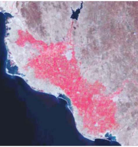
3 CORE_009 image Fires in South Sudan DEIMOS-1, January m Multi-spectral (R,G,B) 1 DEIMOS Contribution to Previous CSCDA Phases CSCDA Workshop, April April DEIMOS DEIMOS Imaging Imaging S.L.U. S.L.U. 3
, with 24/7/365 service Member of the Disaster")
 coupled with high resolution (22m GSD")

 assure one contact with")
4 The DEIMOS-1 Earth Observation System First Spanish Earth Observation satellite Owned and operated by Elecnor Deimos Imaging (Spain), with 24/7/365 service Member of the Disaster Monitoring Constellation (DMC) second generation Launched in 2009 on a 650-km ascending SSO, with lifetime > 7 years Very wide swath (650km) coupled with high resolution (22m 10 bits) Three spectral bands (R,G,NIR) similar to Landsat to assure continuity with existing tools and harmonization with historical data Synthetic blue band can be generated for natural-color imagery System capacity > 5,000,000 km 2 /day, with 3-day average revisit time worldwide Two ground stations (Spain+Norway) assure one contact with up/download per orbit 4
 Temporal window: about 20 months (2009-2010) DEIMOS-1 coverage effort for the participation in the DAP_MG2_25 dataset; Left: image footprints; Right: image")
5 : Data Access Grant DAP_MG2_25: Sub-Saharian Africa AoI: 48 Countries and Confluence Points for Sub-Saharan Africa Satellites: DMC satellites, including DEIMOS-1 (campaign manager: DMCii) Temporal window: about 20 months ( ) DEIMOS-1 coverage effort for the participation in the DAP_MG2_25 dataset; Left: image footprints; Right: image quicklooks 5
 Confluence Points Satellites: DEIMOS-1 Temporal window: 12 months (2011) CORE_009 Summary")
6 : Data WareHouse 1 CORE_009: Sub-Saharian Africa 2011 AoI: 48 Countries (24 M Km2) and 2,047 (30x30 km) Confluence Points Satellites: DEIMOS-1 Temporal window: 12 months (2011) CORE_009 Summary Results 6


7 : Data WareHouse 1 CORE_009: Sub-Saharian Africa 2011 Confluence point in DR of Congo Confluence point in Gambia Quicklooks of the images comprising CORE_009 Country Coverage for South Africa 7
8 : Data WareHouse 1 ADD Dataset 8

9 Crop fields in Corcoran, CA (US) DEIMOS-1, June m Multi-spectral (R,G,B) 2 CSCDA Data WareHouse 2: HR Contribution CSCDA Workshop, April April DEIMOS DEIMOS Imaging Imaging S.L.U. S.L.U. 9
10 : Data WareHouse 2 EUR_HR2_MULTITEMP: 7 monthly coverage of Europe in 2015 AoI: 39 Countries (6 M Km2), same coverage of HR_IMAGE_2015 Satellites: DEIMOS-1, UK-DMC2 Temporal window: 1 month for each coverage (Apr.1 to Oct.31, 2015) DEIMOS-1 (Deimos Imaging) UK-DMC2 (DMCii / Airbus DS Geo) 10
 Spatial resolution: 22 m (R,G,NIR) Radiometric resolution: 8 bits Target Cloud")
11 : Data WareHouse 2 EUR_HR2_MULTITEMP: 7 monthly coverage of Europe in 2015 Applications: Continuation of previous pan-european land services and land use/land cover mapping efforts Multitemporal agricultural studies and crop classification Gap bridging for Sentinel-2 Product: Ortho products (L1T) Spatial resolution: 22 m (R,G,NIR) Radiometric resolution: 8 bits Target Cloud Cover: Zone A: CloudFree20 Zone B,C: CloudFree10 Delivery: Within 30 days from ESA acceptance 11
 DEIMOS-1")
12 : Data WareHouse 2 EUR_HR2_MULTITEMP: Example of daily coverage (today) DEIMOS-1 UK-DMC2 12

13 : Data WareHouse 2 EUR_HR2_MULTITEMP: Campaign started on April 1 st First DEIMOS-1 image acquired over Cyprus and Turkey 13


14 : Data WareHouse 2 EUR_HR2_MULTITEMP: Status of April Coverage as of April 17 Around 65% of cloud-free coverage already achieved DEIMOS-1 coverage as of April 17 UK-DMC2 coverage as of April 17 14
 coverage as of April 17")
15 : Data WareHouse 2 Overall (DEIMOS-1+UK-DMC2) coverage as of April 17 EUR_HR2_MULTITEMP - Overall (DEIMOS-1+UK-DMC2) coverage as of April 17 15
16 : Data WareHouse 2 - OPTION EUR_HR2_MULTITEMP: 7 monthly coverage of Europe in 2016 Replica of the 2015 dataset AoI: 39 Countries (6 M Km2); Satellites: DEIMOS-1, UK-DMC2 Temporal window: 1 month for each coverage (Apr.1 to Oct.31, 2016) 16
17 : Data WareHouse 2 - OPTION HR2_OPTICAL_GLOBAL: global coverage ( ) Global Coverage (150 M Km2), same as HR1_OPTICAL_GLOBAL Satellites: DEIMOS-1, UK-DMC2 Temporal window: one coverage in 1 or 2 years (2015 / 2016) Various acquisition options still open 17

 2014 (713 images) 2013 (722")
18 : Data WareHouse 2 - OPTION Full yearly coverages of Africa , complement of DAP_MG2_25 & CORE_ (1071 images) 2014 (713 images) 2013 (722 images) 18

19 The Four Towers of Madrid, the tallest buildings in Spain DEIMOS-2, August cm Pan-Sharpened 3 CSCDA Data WareHouse 2: VHR Contribution CSCDA Workshop, April April DEIMOS DEIMOS Imaging Imaging S.L.U. S.L.U. 19
 and ELECNOR DEIMOS")
 @")


20 The DEIMOS-2/DubaiSat-2 Constellation Very-high resolution (1m GSD Pan, 4m MS) multispectral optical satellites Main product: 75-cm pan-sharpened Developed by EIAST (UAE) and ELECNOR DEIMOS (Spain) with SATREC-i (South Korea) End-to-end system designed for a cost-effective and highly responsive service Push-broom camera with 5 spectral channels (1 pan, 4 MS bands: R, G, B, 10 bits 12/24 km swath, stereo-par capability, system capacity >150,000 km 2 /day/satellite Agile platform with ±45º off-nadir tilting capacity 2-day average revisit time worldwide for each satellite, 1-day when used in constellation Multiple ground stations (UAE+Spain+polars) assure at least one contact per orbit, with each satellite, with telecommand upload and telemetry & data download 20
 Orbit: 620-km ascending sun-synch with 10:30 local time")


21 DEIMOS-2 Status DEIMOS-2 Launch: June 19, 2014 from Yasni (Russia) Orbit: 620-km ascending sun-synch with 10:30 local time at node Commissioning: Completed in October 2014 IOC: Start of pre-operational commercial activities: November 1 st, 2014 FOC: Full Operational Capability reached in April 2015 One of the first DEIMOS-2 images acquired on launch day, June 19, 2014 (Doha, Qatar) 21
 Participants: DEIMOS-2, DUBAISAT-2 Temporal window: June-September 2015 (backup: Jun-Sep 2016)")
22 : Data WareHouse 2 VHR_IMAGE_2015: one VHR coverage of Europe ( ) AoI: 17 Large Regions (1 M Km2) Participants: DEIMOS-2, DUBAISAT-2 Temporal window: June-September 2015 (backup: Jun-Sep 2016) 22
 DEIMOS-2 available from April 1 st as DW2 Contributing")
23 : Data WareHouse 2 Contribution to Emergency Service Pre-evaluation in February-March 2015 with Ebro River floods (Spain) DEIMOS-2 available from April 1 st as DW2 Contributing Mission 23

 pansharpened")
 pansharpened")
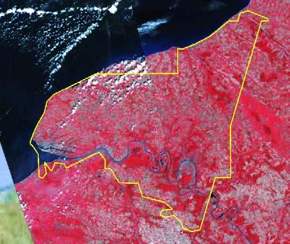
24 : Data WareHouse 2 Contribution to Emergency Service Example of Ebro floods (Spain) DEIMOS-2 (R-G-NIR) pansharpened image, March 2, 2015 Detail of DEIMOS-2 (R-G-B) pansharpened image, March 2,

25 The Jumeirah Palm Island, Dubai, UAE DubaiSat-2, March m Pan-Sharpened 4 CSCDA Data WareHouse 2: Additional Datasets CSCDA Workshop, April April DEIMOS DEIMOS Imaging Imaging S.L.U. S.L.U. 25


26 The PanGeo Alliance 26

27 DEIMOS Satellite Fleet for Data WareHouse 2 27

 www.deimos-imaging.")

28 DEIMOS Space an ELECNOR company Tres Cantos (Spain) DEIMOS Imaging an ELECNOR company Boecillo & Puertollano (Spain) DEIMOS Satellite Systems an ELECNOR company Puertollano (Spain) 28
Deimos-2 Post-launch radiometric calibration
 Deimos-2 Post-launch radiometric Jorge Gil Alfredo Romo Cristina Moclán Fabrizio Pirondini (Elecnor Deimos Imaging) ELECNOR DEIMOS, Spain JACIE 2015 14th Annual Civil Commercial Imagery Evaluation Workshop
COPERNICUS SPACE DATA OFFER FOR PUBLIC AUTHORITIES DISTRIBUTED BY ESA
 COPERNICUS SPACE DATA OFFER FOR PUBLIC AUTHORITIES DISTRIBUTED BY ESA The Copernicus Space Component Data Access (CSC-DA) service - financed by the EU and operated by ESA - grants National Public Authorities
DEIMOS FOREIGN DIRECT INVESTMENT CASE IN UK
 DEIMOS FOREIGN DIRECT INVESTMENT CASE IN UK UK SPACE CONFERENCE EXPANDING FRONTIERS MAY 2017 Ismael López Deputy CEO @ElecnorDeimos All Rights Reserved No part of this document may be reproduced, stored,
UK-DMC 2 and Deimos-1, New DMC Sensors for Agricultural Monitoring. Owen Hawkins DMC International Imaging Ltd
 UK-DMC 2 and Deimos-1, New DMC Sensors for Agricultural Monitoring Owen Hawkins DMC International Imaging Ltd Full Spectrum Satellite Solutions Design Manufacture Assembly, Integration & Test Launch Services
UrtheCast s High Resolution Imagery, HD Video and Synthetic Aperture Radar from Space for Smart Earth Observations Dr. Rao S.
 UrtheCast s High Resolution Imagery, HD Video and Synthetic Aperture Radar from Space for Smart Earth Observations Dr. Rao S. Ramayanam Vice President Middle East, Africa and South Asia Geo Smart Asia
Sentinel-1 Mission Status
 Sentinel-1 Mission Status Pierre Potin, Sentinel-1 Mission Manager 5TH GEOGLAM RAPP Workshop 16-17 May 2017, ESRIN Sentinel-1: Copernicus radar imaging mission for ocean, land, emergency Part of the Copernicus
sentinel-2 COLOUR VISION FOR COPERNICUS
 sentinel-2 COLOUR VISION FOR COPERNICUS SATELLITES TO SERVE By providing a set of key information services for a wide range of practical applications, Europe s Copernicus programme is providing a step
Challenges for the operational assimilation of satellite image data in agrometeorological models
 Challenges for the operational assimilation of satellite image data in agrometeorological models Mark Danson Centre for Environmental Systems Research, University of Salford, UK 0 Objectives The main objective
Spanish national plan for land observation: new collaborative production system in Europe
 ADVANCE UNEDITED VERSION UNITED NATIONS E/CONF.103/5/Add.1 Economic and Social Affairs 9 July 2013 Tenth United Nations Regional Cartographic Conference for the Americas New York, 19-23, August 2013 Item
Imaging the whole Earth every day. Josh Alban VP, Business Development
 Imaging the whole Earth every day Josh Alban VP, Business Development josh@planet.com Planet Labs helps you detect and act on change by imaging the whole Earth everyday. Challenges Limited Coverage Low
DEIMOS-1 Imagery. User Guide
 DEIMOS 1 Imagery Code : D1-USERGUIDE Date : 11/08/2015 Issue : 1.2 Page : 1 of 40 DEIMOS-1 Imagery Code Issue Date : : : D1-USERGUIDE 1.2 11/08/2015 Page : 2 of 40 Table of Contents 1. Introduction...
Status of the Sentinel-5 Precursor Presented by C. Zehner S5p, S4, and S5 Missions Manager - ESA
 Status of the Sentinel-5 Precursor Presented by C. Zehner S5p, S4, and S5 Missions Manager - ESA European response to global needs: to manage the environment, to mitigate the effects of climate change
Open call for tenders No EEA/MDI/14/001
 1 April 2014 Clarification No 1 Reference: Title: Open call for tenders No EEA/MDI/14/001 Copernicus Initial Operations 2011-2013 - Land Monitoring Service Local Component: riparian zones Question 1 Section
Collaborative Systems for the Creation of Marine Services
 Collaborative Systems for the Creation of Marine Services INSPIRE 2016 Nuno Almeida Nuno Catarino Barcelona, 28 th September 2016 Elecnor Deimos is a trademark which encompasses Elecnor Group companies
Systems Engineering in Venus Satellite
 Systems Engineering in Venus Satellite How to benefit from system engineering process in designing a microsatellite Jacob Herscovitz Venus Project Manager RAFAEL - Israel 1 Presentation Contents Introduction
A Regional Microsatellite Constellation with Electric Propulsion In Support of Tuscan Agriculture
 Berlin, 20 th - 24 th 2015 University of Pisa 10 th IAA Symposium on Small Satellites for Earth Observation Student Conference A Regional Microsatellite Constellation with Electric Propulsion In Support
10 emergency observation requests were successfully processed during the period
 ISRO s Inputs for the Sentinel Asia DPN and JPT meeting being held during 13-16, 16, November 2012 November 2012 Sentinel Asia Activity Spectrum - A dedicated Sentinel Asia server established at NRSC,
CLICK HERE TO KNOW MORE
 CLICK HERE TO KNOW MORE UrtheCast Constellations: World s first fully-integrated Optical and SAR constellations Fabrizio Pirondini, CEO Deimos Imaging & GM Earth Observation UrtheCast Geospatial World
Current Status of the ALOS-2 Operation and PALSAR-2 Calibration Activities
 Current Status of the ALOS-2 Operation and PALSAR-2 Calibration Activities Takeshi Motohka, Ryo Natsuaki, Yukihiro Kankaku, Shinichi Suzuki, Masanobu Shimada (JAXA) Osamu Isoguchi (RESTEC) CEOS SAR CALVAL
sentinel-3 A BIGGER PICTURE FOR COPERNICUS
 sentinel-3 A BIGGER PICTURE FOR COPERNICUS SATELLITES TO SERVE By providing a set of key information services for a wide range of practical applications, Europe s Copernicus programme has been put in place
Effective Utilization of Synthetic Aperture Radar (SAR) Imagery in Rapid Damage Assessment
 Imagery in Rapid Damage Assessment") Effective Utilization of Synthetic Aperture Radar (SAR) Imagery in Rapid Damage Assessment Case Study Pakistan Floods SUPARCO M. Maisam Raza, Ahmad H. Rabbani SEQUENCE Flood Monitoring using Satellite
Effective Utilization of Synthetic Aperture Radar (SAR) Imagery in Rapid Damage Assessment Case Study Pakistan Floods SUPARCO M. Maisam Raza, Ahmad H. Rabbani SEQUENCE Flood Monitoring using Satellite
An Update on EUMETSAT Programmes and Plans. Dieter Klaes on behalf of EUMETSAT teams
 An Update on EUMETSAT Programmes and Plans Dieter Klaes on behalf of EUMETSAT teams 1 21 st International TOVS Study Conference (ITSC), Darmstadt, Germany, 29 November 2017 5 December 2017 Current EUMETSAT
Sentinel-1 Mission Status
 Sentinel-1 Mission Status Pierre Potin, Sentinel-1 Mission Manager, ESA Luca Martino, Technical Support Engineer, ESA... and the Sentinel-1 operations team PSTG SAR Coordination Working Group 14 December
UN COPUOS 52 nd session of the Scientific and Technical Subcommittee. COPERNICUS - an European Achievement. S. Jutz Head, ESA Copernicus Space Office
 UN COPUOS 52 nd session of the Scientific and Technical Subcommittee COPERNICUS - an European Achievement S. Jutz Head, ESA Copernicus Space Office 11 Feb 2015, Vienna 1 2 What is Copernicus? European
SPACE TECHNOLOGY INSTITUTE, VNREDSat-1 and DATA PROVIDER NODE (DPN) REPORT
 REPORT") 4th Joint Project Team Meeting for Sentinel Asia STEP3 (JPTM2017) 8-9 March 2017 SPACE TECHNOLOGY INSTITUTE, VNREDSat-1 and DATA PROVIDER NODE (DPN) REPORT www.sti.vast.ac.vn CONTENT 1. Overview of Space
4th Joint Project Team Meeting for Sentinel Asia STEP3 (JPTM2017) 8-9 March 2017 SPACE TECHNOLOGY INSTITUTE, VNREDSat-1 and DATA PROVIDER NODE (DPN) REPORT www.sti.vast.ac.vn CONTENT 1. Overview of Space
EUMETSAT Satellite Status
 EUMETSAT Satellite Status Dr. K. Dieter Klaes EUMETSAT 1 ET-SAT Meeting 4-6 April 2017, WMO, Geneva, Switzerland EUMETSAT is an intergovernmental organisation with 30 Member States and 1 Cooperating State
Floating Ice: Progress in Addressing Science Goals
 Polar Floating Ice: Progress in Addressing Science Goals Stephen Howell 1, Leif Toudal Pedersen 2 and Roberto Saldo 3 1 Environment Canada, Climate Research Division, Toronto, Canada 2 Danish Meteorological
Copernicus Today and Tomorrow GEO Week Group on Earth Observation Geneva, 16 January 2014 The Copernicus Space Infrastructure
 Copernicus Today and Tomorrow GEO Week Group on Earth Observation Geneva, 16 January 2014 The Copernicus Space Infrastructure Thomas Beer, Policy Coordinator, Copernicus Space Office, ESA-ESRIN, Frascati
U s i n g t h e E S A / E U M E T C A S T N a v i g a t o r s
 U s i n g t h e E S A / E U M E T C A S T N a v i g a t o r s Copernicus User Uptake Information Sessions Copernicus EU Copernicus EU Copernicus EU www.copernicus.eu I N T R O D U C T I O N O F U S E C
EO data Acquisition and Access
 EO data Acquisition and Access Copernicus EMS User Workshop 2016 Lena Stern,Fabrizia Cattaneo 15/03/2016 Issue/Revision:. Reference: Status: Content Role of ESA in Copernicus Overview of the Copernicus
CHRIS HYPERSPECTRAL MISSION FIVE YEARS SINCE LAUNCH
 CHRIS HYPERSPECTRAL MISSION FIVE YEARS SINCE LAUNCH Paul Stephens Dr Mike Cutter Fordate Island, Indonesia Mission Overview Instrument Overview Observation Programme Applications Snapshots Future Plans
The Copernicus Sentinel-5 Mission: Daily Global Data for Air Quality, Climate and Stratospheric Ozone Applications
 SENTINEL-5 The Copernicus Sentinel-5 Mission: Daily Global Data for Air Quality, Climate and Stratospheric Ozone Applications Yasjka Meijer RHEA for ESA, Noordwijk, NL 15/04/2016 Co-Authors: Jörg Langen,
Time Series Analysis with SAR & Optical Satellite Data
 Time Series Analysis with SAR & Optical Satellite Data Thomas Bahr ESRI European User Conference Thursday October 2015 harris.com Motivation Changes in land surface characteristics mirror a multitude of
METEOSAT THIRD GENERATION
 METEOSAT THIRD GENERATION FACTS AND FIGURES MONITORING WEATHER AND CLIMATE FROM SPACE A HIGHLY INNOVATIVE GEOSTATIONARY SATELLITE SYSTEM FOR EUROPE AND AFRICA The Meteosat Third Generation (MTG) system
Contribution to global Earth observation from satellites
 Contribution to global Earth observation from satellites - JAXA s Earth Observation strategy - April 16, 2008 Makoto Kajii Japan Aerospace Exploration Agency Earth Observation Summits and GEOSS 1 st EO
C N E S, U M R I R I S A
 M O N I T O R I N G U R B A N A R E A S W I T H S E N T I N E L - 2. APPLICATION TO THE UPDATE OF THE COPERNICUS HIGH RESOLUTION LAYER IMPERVIOUSNESS DEGREE O c t o b e r 2 5 th 2016, Brussels A n t o
Long-Term Time Series of Water Vapour Total Columns from GOME, SCIAMACHY and GOME-2
 Graphics: ESA Graphics: ESA Graphics: ESA Long-Term Time Series of Water Vapour Total Columns from GOME, SCIAMACHY and GOME-2 S. Noël, S. Mieruch, H. Bovensmann, J. P. Burrows Institute of Environmental
CALIBRATION over the Moon An introduction to «POLO»
 CALIBRATION over the Moon An introduction to «POLO» Sophie Lachérade Bertrand Fougnie Aimé Meygret CEOS - IVOS 25, Frascati, 19-21 march 2013 Introduction It has been demonstrated that the Moon is a very
Towards eenvironment Prague, March GMES Space Component. Josef Aschbacher Head, ESA GMES Space Office
 Towards eenvironment Prague, 25-27 March 2009 GMES Space Component Josef Aschbacher Head, ESA GMES Space Office Prague from Space Segment 2 05 Nov 2003 CNES 2003 GISAT 2007 ESA GSELAND GMES is an EU led
Remote sensing data uses and supply in Vietnam. Dr. Chu Hải Tùng National Remote Sensing Department, Ministry of Natural Resource and Environment
 Remote sensing data uses and supply in Vietnam Dr. Chu Hải Tùng National Remote Sensing Department, Ministry of Natural Resource and Environment Content Uses of remote sensing data in Vietnam Roles of
UK Contribution to the European CORINE Land Cover
 Centre for Landscape andwww.le.ac.uk/clcr Climate Research CENTRE FOR Landscape and Climate Research UK Contribution to the European CORINE Land Cover Dr Beth Cole Corine Coordination of Information on
Opportunities for advanced Remote Sensing; an outsider s perspective
 Opportunities for advanced Remote Sensing; an outsider s perspective Ramon Hanssen Delft University of Technology 1 Starting questions Can we do more with the data we are already acquire? What s in stock
C o p e r n i c u s L a n d M o n i t o r i n g S e r v i c e
 C o p e r n i c u s L a n d M o n i t o r i n g S e r v i c e Integration into existing Snow and Ice Services and draft product specifications Annett BARTSCH b.geos Copernicus High Resolution Snow and
C o p e r n i c u s a n d W I G O S
 C o p e r n i c u s a n d W I G O S Jean-Noël Thépaut & Mark Dowell 24 October 2017 GEO XIV, Washington DC, 23-28 October 2017 T h e C o p e r n i c u s P r o g r a m m e Copernicus is the European Union
GEOG Lecture 8. Orbits, scale and trade-offs
 Environmental Remote Sensing GEOG 2021 Lecture 8 Orbits, scale and trade-offs Orbits revisit Orbits geostationary (36 000 km altitude) polar orbiting (200-1000 km altitude) Orbits revisit Orbits geostationary
Infrastructure monitoring using SAR interferometry
 Infrastructure monitoring using SAR interferometry Hossein Nahavandchi Roghayeh Shamshiri Norwegian University of Science and Technology (NTNU), Department of Civil and Environmental Engineering Geodesy
Sentinel-1 Long Duration Mutual Interference
 MPC-S1 Sentinel-1 Long Duration Mutual Interference Reference: Nomenclature: MPC-0432 DI-MPC-ARC Issue: 1. 0 Date: 2018,Dec.04 MPC-0432 DI-MPC-ARC V1.0 2018,Dec.04 i.1 Chronology Issues: Issue: Date: Reason
Drought Characterization. Examination of Extreme Precipitation Events
 Drought Characterization Examination of Extreme Precipitation Events Extreme Precipitation Events During the Drought For the drought years (1999-2005) daily precipitation data was analyzed to find extreme
RUSSIAN EARTH OBSERVATION MISSIONS: satellites, ground segment and data access evolution
 RUSSIAN EARTH OBSERVATION MISSIONS: satellites, ground segment and data access evolution Tamara Ganina Deputy Chief of Prospective Development Dep. WGISS-40 UKSA, Harwell, UK September 28 October 2, 2015
Copernicus Overview and Emergency Management Service
 Copernicus Overview and Emergency Management Service Frédéric BASTIDE European Commission Open informal session of the United Nations Inter-Agency Meeting on Outer Space Activities 12 March 2013, Geneva
PROBA 1. F. Teston ESA/ESTEC D/TEC-EL
 PROBA 1 F. Teston ESA/ESTEC D/TEC-EL Frederic.Teston@esa.int PROBA 1 launch PROBA 1 has been launched on 21 October 2001 Orbital parameters: Altitude: 681-561 km Near polar (inclination of 97.9 ) Sun-synchronous
National Satellite Data Centre and Finnish Sentinel Collaborative Ground Segment. Jyri Heilimo Finnish Meteorological Instute
 National Satellite Data Centre and Finnish Sentinel Collaborative Ground Segment Jyri Heilimo Finnish Meteorological Instute Sodankylä National Satellite Data Centre National satellite data centre providing
Sentinel Asia System Operation for Disaster Management in Sri Lanka Major General L.B.R. Mark (Retd) Director General Disaster Management Centre
 Director General Disaster Management Centre") Sentinel Asia System Operation for Disaster Management in Sri Lanka Major General L.B.R. Mark (Retd) Director General Disaster Management Centre Government of Sri Lanka OUTLINE Background Disasters in
Sentinel Asia System Operation for Disaster Management in Sri Lanka Major General L.B.R. Mark (Retd) Director General Disaster Management Centre Government of Sri Lanka OUTLINE Background Disasters in
Status of ESA EO Programmes
 Status of ESA EO Programmes 54 th ESSC Plenary Meeting 24 November 2017 Maurice Borgeaud, ESA Head of the ESA Earth Observation Science, Applications and Climate Department Issue/Revision: 0.0 Reference:
Green areas: numerous positive effects for sustainable metropolis Satellite images : an easy way to map vegetation
 Green areas: numerous positive effects for sustainable metropolis Satellite images : an easy way to map vegetation Copernicus Training and Information Session 10 and 11 may 2017 in Lund, Sweden Dominique
SAR Coordination for Snow Products
 Polar SAR Coordination Working Meeting 5 SAR Coordination for Snow Products David Small 1, Thomas Nagler 2, David Jäger 1, Christoph Rohner 1, Adrian Schubert 1 1: University of Zurich, Switzerland 2:
Orbital Orbital Chara Char cte act ristics eristics of the Helios of the Helio sy s s s y te st m Orbit : Low: Sun-synchronous: Quasi-polar: Phased:
 Orbital Characteristics of the Helios system Orbit : Ë Low: suitable for High Resolution imagery. ËSun-synchronous: allows for regular illumination of the observed zones as the satellite always passes
Sentinel and ESA Third-Party Mission data access and processing tools
 Sentinel and ESA Third-Party Mission data access and processing tools Magdalena Fitrzyk RSAC c/o ESA ESRIN 11/09/2018 Content Copernicus Sentinel missions Copernicus Open Access Hub: Sentinels Data Access
Status report on current and future satellite systems by EUMETSAT Presented to CGMS-44, Plenary session, agenda item D.1
 Status report on current and future satellite systems by EUMETSAT Presented to CGMS-44, Plenary session, agenda item D.1 CGMS-44-EUMETSAT-WP-19.ppt, version 1 (# 859110), 8 June 2016 MISSION PLANNING YEAR...
Orbit Design Marcelo Suárez. 6th Science Meeting; Seattle, WA, USA July 2010
 Orbit Design Marcelo Suárez Orbit Design Requirements The following Science Requirements provided drivers for Orbit Design: Global Coverage: the entire extent (100%) of the ice-free ocean surface to at
Interannual variation of MODIS NDVI in Lake Taihu and its relation to climate in submerged macrophyte region
 Yale-NUIST Center on Atmospheric Environment Interannual variation of MODIS NDVI in Lake Taihu and its relation to climate in submerged macrophyte region ZhangZhen 2015.07.10 1 Outline Introduction Data
Indian Earth Observation Programme
 Indian Earth Observation Programme Dr. Jai Singh Parihar Dy. Director Remote Sensing Applications Area (RESA) Space Applications Centre (ISRO) Ahmedabad 380 015 India jsparihar@sac.isro.gov.in Presentation
Remote Sensing I: Basics
 Remote Sensing I: Basics Kelly M. Brunt Earth System Science Interdisciplinary Center, University of Maryland Cryospheric Science Laboratory, Goddard Space Flight Center kelly.m.brunt@nasa.gov (Based on
VNREDSat-1. Vietnam Natural Resources, Environment and Disaster monitoring Satellite. Lai Anh Khoi SPACE TECHNOLOGY INSTITUTE
 VNREDSat-1 Vietnam Natural Resources, Environment and Disaster monitoring Satellite Lai Anh Khoi SPACE TECHNOLOGY INSTITUTE JPTM2014 Yangon, Nov. 19-21, 2014 General information (1) Project Owner: Vietnam
Outline. Artificial night lighting as seen from space. Artificial night lighting as seen from space. Applications based on DMSP nighttime lights
 -1 - Outline Satellite observed nighttime lights as an indicator of human induced stress on coral C. Aubrecht, C.D. Elvidge August 22, 2008 Kuffner Observatory Vienna, Austria Artificial night lighting
Angelika Dehn Rob Koopman 10 Years GOME on ERS-2 Workshop
 Angelika Dehn (ADehn@serco.it), Rob Koopman (Rob.Koopman@esa.int), Overview I. ERS-2 Mission History 1. Mission Plan Highlights 2. GOME Special Operations II. GOME-1 Engineering Performance 1. Routine
FLEX MISSION: FLORIS Instrument
 FLEX MISSION: FLORIS Instrument Primo Workshop su Data Exploitation della missione PRISMA, precursore delle missioni iperspettrali nazionali ASI Roma, 2 Marzo 2017 An ESA Earth Explorer Mission to observe
ESA-ESTEC, Noordwijk, The Netherlands
 Fully Automated Mission Planning and Capacity Analysis Tool for the DEIMOS-2 Agile Satellite Workshop on Simulation for European Space Programmes (SESP) 24-26 March 2015 ESA-ESTEC, Noordwijk, The Netherlands
Earth Observation Satellites Dawn of Application Specific Satellite Data. Date: 26 July 2017
 Earth Observation Satellites Dawn of Application Specific Satellite Data Date: 26 July 2017 Introducing a World of New Possibilities Satellite imagery is a critical fountain of information on al levels
Copernicus Space Component Status & Evolution
 Copernicus Space Component Status & Evolution ESCAP, Bangkok 09 October 2017 Simon Jutz Head of the ESA Copernicus Space Office Directorate of Earth Observation Programmes 28 satellites in development
Space research. Horizon Work Programme. "Countdown to Horizon 2020 Space" Earth Observation topics. Brussels, 12 December 2013
 Space research Horizon 2020 - Work Programme "Countdown to Horizon 2020 Space" Earth Observation topics Brussels, 12 December 2013 richard.gilmore@ec.europa.eu Table of contents FP/Copernicus - general
The Landsat Program and its Products: Global Land Surveys. Garik Gutman LCLUC Program Manager NASA Headquarters Washington, DC
 The Landsat Program and its Products: Global Land Surveys Garik Gutman LCLUC Program Manager NASA Headquarters Washington, DC 1 Land-Cover/Land-Use Change Program LCLUC is an interdisciplinary scientific
Jay Lawrimore NOAA National Climatic Data Center 9 October 2013
 Jay Lawrimore NOAA National Climatic Data Center 9 October 2013 Daily data GHCN-Daily as the GSN Archive Monthly data GHCN-Monthly and CLIMAT messages International Surface Temperature Initiative Global
A state of the art and user driven Copernicus service Physics and Biogeochemistry
 C M E M S P r e s e n t a n d F u t u r e R e q u i r e m e n t s f o r I n - S i t u a n d S a t e l l i t e O b s e r v a t i o n s Antonio REPPUCCI; Pierre Yves LE TRAON Mercator Ocean International
Geometry Benchmark of DEIMOS-2 for the CAP Control with Remote Sensing
 Geometry Benchmark of DEIMOS-2 for the CAP Control with Remote Sensing Geometric benchmarking over Maussane test site for the Common Agriculture Policy Blanka Vajsová Cristina Moclán Pär Johan Åstrand
Project title. Evaluation of MIR data from SPOT4/VEGETATION for the monitoring of climatic phenomena impact on vegetation
 Project title 1 Evaluation of MIR data from SPOT4/VEGETATION for the monitoring of climatic phenomena impact on vegetation Principal investigator: M-Christine IMBERTI Co-investigator: Frédéric BIARD Stockholm
The VENμS mission: Earth Observation with High Spatial and Temporal Resolution Capabilities
 Ben Gurion University The VENμS mission: Earth Observation with High Spatial and Temporal Resolution Capabilities G. Dedieu 1, O. Hagolle 2, A. Karnieli 3, S. Cherchali 2 P. Ferrier 2 and Y. Yaniv 4 1
APPENDIX 2 OVERVIEW OF THE GLOBAL PRECIPITATION MEASUREMENT (GPM) AND THE TROPICAL RAINFALL MEASURING MISSION (TRMM) 2-1
 AND THE TROPICAL RAINFALL MEASURING MISSION (TRMM) 2-1") APPENDIX 2 OVERVIEW OF THE GLOBAL PRECIPITATION MEASUREMENT (GPM) AND THE TROPICAL RAINFALL MEASURING MISSION (TRMM) 2-1 1. Introduction Precipitation is one of most important environmental parameters.
APPENDIX 2 OVERVIEW OF THE GLOBAL PRECIPITATION MEASUREMENT (GPM) AND THE TROPICAL RAINFALL MEASURING MISSION (TRMM) 2-1 1. Introduction Precipitation is one of most important environmental parameters.
Intelligent City Management
 Intelligent City Management Based on Land Cover Feature Changes Detected by Satellite Imagery Twenty First Century Aerospace Technology (21AT) www.21at.com.cn Geospatial World Forum 2016 Outline 01 Introduction
Sentinel-5 Precursor: Preparing the first Copernicus Atmospheric Mission
 Sentinel-5 Precursor: Preparing the first Copernicus Atmospheric Mission Herbert Nett 1, Kevin McMullan 1, Paul Ingmann 1, Thorsten Fehr 2 (1) ESA/ESTEC, Keplerlaan 1, NL-2201 AZ Noordwijk (2) ESA/ESRIN,
Supporting GPSC Cities with Satellite Earth Observation for Sustainable Urban Development
 Supporting GPSC Cities with Satellite Earth Observation for Sustainable Urban Development Global Platform for Sustainable Cities African Regional Workshop 14 May 2018 AfDB Headquarters Abidjan, Côte d'ivoire
RGB Products: an easy and practical way to display multispectral satellite data (in combination with derived products)
") RGB Products: an easy and practical way to display multispectral satellite data (in combination with derived products) Dr. Jochen Kerkmann Training Officer EUMETSAT Multi-channel GEO satellites today Him-08
RGB Products: an easy and practical way to display multispectral satellite data (in combination with derived products) Dr. Jochen Kerkmann Training Officer EUMETSAT Multi-channel GEO satellites today Him-08
Measuring Carbon Dioxide from the A-Train: The OCO-2 Mission
 Measuring Carbon Dioxide from the A-Train: The OCO-2 Mission David Crisp, OCO-2 Science Team Leader for the OCO-2 Science Team Jet Propulsion Laboratory, California Institute of Technology March 2013 Copyright
Living Atlas of the World: The Road Ahead. Deane Kensok Sean Breyer
 Living Atlas of the World: The Road Ahead Deane Kensok Sean Breyer ArcGIS includes a Living Atlas of the World Maps and Layers from Esri and Thousands of Contributors The Collection is growing and changing
SENTINEL 1 Mission status and contribution to PSTG
 PSTG SAR WG meeting, 12 September 2016, ESTEC SENTINEL 1 Mission status and contribution to PSTG First Sentinel1B Images 28 April 2016 Sentinel-1B Launch from Kourou, 25 April 2016 Sentinel 1 Mission Operations
CNES WGCV-36 Report Cal/Val Activities
 CEOS WGCV Meeting 13-17th May 2013, Shangai, China CNES WGCV-36 Report Cal/Val Activities Bertrand Fougnie, Sophie Lachérade, Denis Jouglet, Eric Péquignot, Aimé Meygret, Patrice Henry CNES 1 Summary Pleiades
Time and resolution : COSMO-SkyMed VHR data in support to precision farming applications
 17 th GEOCAP Conference Geomatics in Support of the CAP Tallinn, 24 November 2011 Time and resolution : COSMO-SkyMed VHR data in support to precision farming applications e-geos Headquarter Contrada Terlecchie
PETBOX: FLIGHT QUALIFIED TOOLS FOR ATMOSPHERIC FLIGHT
 PETBOX: FLIGHT QUALIFIED TOOLS FOR ATMOSPHERIC FLIGHT Davide Bonetti, Cristina Parigini, Gabriele De Zaiacomo, Irene Pontijas Fuentes, Gonzalo Blanco Arnao, David Riley, Mariano Sánchez Nogales (speaker)
ADEN ALOS AVNIR-2 C YCLIC R EPORT C YCLIC R EPORT #29 28 J ULY 2009 TO 12 S EPTEMBER 2009
 ADEN ALOS AVNIR-2 C YCLIC R EPORT C YCLIC R EPORT #29 28 J ULY 2009 TO 12 S EPTEMBER 2009 This RGB composite AVNIR-2 image has been taken on the 16th of September, 2008 from orbit 14095 over the desert
CadasterENV Sweden Time series in support of a multi-purpose land cover mapping system at national scale
 CadasterENV Sweden Time series in support of a multi-purpose land cover mapping system at national scale Mats Rosengren, Camilla Jönsson ; Metria AB Marc Paganini ; ESA ESRIN Background CadasterENV Sweden
ESA s Earth Observation Programmes
 ESA s Earth Observation Programmes 2015 DRAGON Symposium Interlaken, 23 June 2015 Maurice Borgeaud Head of the Department Science, Applications, and Future Technologies ESA Earth Observation Programmes
Using the moon as a calibration source for a fleet of satellites
 Using the moon as a calibration source for a fleet of satellites Arin Jumpasut, Adriana Fukuzato, Ignacio Zuleta Kure Atoll, Hawaii, USA May 12, 2016 Introduction Singapore Strait, Singapore July 29, 2016
Mapping Water Resources and Reservoirs for Climate Resilience in Zambezi River Basin
 Mapping Water Resources and Reservoirs for Climate Resilience in Zambezi River Basin Corné van der Sande, NEO BV Senior Advisor Earth Observation Services for Monitoring Drought and Water Resources in
Comparison between Multitemporal and Polarimetric SAR Data for Land Cover Classification
 Downloaded from orbit.dtu.dk on: Sep 19, 2018 Comparison between Multitemporal and Polarimetric SAR Data for Land Cover Classification Skriver, Henning Published in: Geoscience and Remote Sensing Symposium,
Emergency Management Service (EMS) mapping
 mapping") GMES Emergency Management Service (EMS) mapping Frédéric BASTIDE GMES unit, European Commission UN-SPIDER Expert Meeting: "Crowdsource Mapping for Disaster Risk Management and Emergency Response" 3-5 December,
GMES Emergency Management Service (EMS) mapping Frédéric BASTIDE GMES unit, European Commission UN-SPIDER Expert Meeting: "Crowdsource Mapping for Disaster Risk Management and Emergency Response" 3-5 December,
DROUGHT INDICES BEING USED FOR THE GREATER HORN OF AFRICA (GHA)
") DROUGHT INDICES BEING USED FOR THE GREATER HORN OF AFRICA (GHA) Christopher Oludhe IGAD Climate Prediction and Applications Centre (ICPAC) Inter-Regional Workshop on Indices and Early Warning Systems for
DROUGHT INDICES BEING USED FOR THE GREATER HORN OF AFRICA (GHA) Christopher Oludhe IGAD Climate Prediction and Applications Centre (ICPAC) Inter-Regional Workshop on Indices and Early Warning Systems for
EUMETSAT products and services for monitoring storms - New missions, more data and more meteorological products
 EUMETSAT products and services for monitoring storms - New missions, more data and more meteorological products Jochen Grandell 1 EUM/RSP/VWG/17/921460 Outline Overview of EUMETSAT missions Current...and
ASSESSMENT OF DIFFERENT WATER STRESS INDICATORS BASED ON EUMETSAT LSA SAF PRODUCTS FOR DROUGHT MONITORING IN EUROPE
 ASSESSMENT OF DIFFERENT WATER STRESS INDICATORS BASED ON EUMETSAT LSA SAF PRODUCTS FOR DROUGHT MONITORING IN EUROPE G. Sepulcre Canto, A. Singleton, J. Vogt European Commission, DG Joint Research Centre,
The current status of FY-3D
 The current status of FY-3D Xiang Fang National Satellite Meteorological Center, China Meteorological Administration (NSMC/CMA) OUTLINE Overview Key instruments onboard FY-3D Products and data service
EU collaborations with NASA LCLUC Program & Current Priorities
 & Current Priorities ioannis Manakos, Dr. Centre for Research and Technology Hellas Information Technologies Institute Visual Analytics, Virtual & Augmented Reality Laboratory European Association of Remote