570 Hazeldean Road, Ottawa, ON Transportation Brief Mattamy Homes. Prepared By: Stantec Consulting Ltd. Project Number:
|
|
|
- Karen Cook
- 5 years ago
- Views:
Transcription
1 570 Hazeldean Road, Ottawa, ON Transportation Brief Mattamy Homes Prepared By: Stantec Consulting Ltd. Project Number: March 2013
2 570 HAZELDEAN ROAD, OTTAWA, ON TRANSPORTATION BRIEF MARCH 2013 TIA GUIDELINES CHECKLIST TRANSPORTATION BRIEF Report Context Municipal Address Comment: Section 1.1 Location relative to major elements of the existing transportation system (e.g. the site is located in the southwest quadrant of the intersection of Main Street/First Street, 600m from the Maple Street Rapid Transit Station) Comment: Section 1.3 Existing land uses or permitted use provisions in the Official Plan, Zoning By-Law, etc. Comment: Section 1.2 Proposed land uses and relevant planning regulations to be used in the analysis Comment: Section 1.3 Proposed development size (building size, number of residential units, etc.) and location on site Comment: Section 1.3 Estimated date of occupancy Comment: Section 3.1 Planned phasing of development Comment: Section 3.1 Proposed number of parking spaces (not relevant for Registration of Plans of Subdivision) Comment: N/A Draft Plan of Subdivision Proposed access points and type of access (full turns, right-in/right-out, turning restrictions, etc.) Comment: Figure 3, Figure 12 Study area Comment: Figure 1 Time periods and phasing Comment: Section 1.4 Horizon years (including reference to phased development) Comment: Section 1.4 Existing Conditions Existing roads, ramps in the study area, including jurisdiction, classification, number of lanes and posted speed limit Comment: Section 2.1 Existing intersections, indicating type of control, lane configurations, turning restrictions and any other relevant data (e.g. extraordinary lane widths, grades, etc.) Comment: Section 2.1 Existing access points to adjacent developments (both sides of all roads bordering the site) Comment: Figure 3 Existing transit system, including stations and stops Comment: Section 2.2 Existing on- and off-road bicycle facilities and pedestrian sidewalks and pathway networks Comment: Section 2.3 Existing system operations (V/C, LOS) Comment: As per the pre-consultation, intersection capacity analysis was not required for this study Major trip generators/attractors within the study area should be indicated
3 570 HAZELDEAN ROAD, OTTAWA, ON TRANSPORTATION BRIEF MARCH 2013 Comment: Section 2.4 Demand Forecasting Trip generation rates Comment: Section Impact Analysis Qualitative assessment of impacts on capacity; non-auto modes; on-site circulation; community Comment: Section 3.8, 3.9, 3.10 Mitigation Measures and Site Design Characteristics Location and timing of proposed changes to existing traffic controls at intersections (e.g. new traffic signals, Stop signs, etc.) Comment: Section 4.0 Mitigation measure required to offset impacts on the surface and Rapid Transit networks Comment: Section 4.0 New or modified elements of the bicycle and pedestrian networks Comment: Section 4.0 Community impact mitigation measures Comment: Section 4.0 Proposed TDM features or programs to support the site development. Comment: Section 4.0
4 570 HAZELDEAN ROAD, OTTAWA, ON TRANSPORTATION BRIEF MARCH 2013 Table of Contents 1.0 INTRODUCTION PURPOSE CONTEXT PROPOSED DEVELOPMENT SCOPE OF THE ASSESSMENT EXISTING TRANSPORTATION CONDITIONS ROADS AND TRAFFIC CONTROL TRANSIT CYCLING AND WALKING TRAFFIC VOLUMES AND MAJOR TRIP GENERATORS FUTURE TRANSPORTATION CONDITIONS HORIZON YEARS AND DEVELOPMENT PHASING MODE SHARE ASSUMPTIONS TRAFFIC FORECASTS Transportation Model Fernbank Community Traffic Forecasts / Generation TRAFFIC DISTRIBUTION AND ASSIGNMENT FUTURE BACKGROUND CONDITIONS TOTAL FUTURE CONDITIONS FUTURE CONDITIONS (5 YEARS BEYOND SITE BUILD-OUT) TRANSIT SERVICE ACTIVE MODES COMMUNITY IMPACTS TRANSPORTATION DEMAND MANAGEMENT SUMMARY AND CONCLUSIONS ml w:\active\ _fernbankdraftplancommunitytransportationstudy\reports\fernbank tb - final222.docx i
5 570 HAZELDEAN ROAD, OTTAWA, ON TRANSPORTATION BRIEF MARCH 2013 List of Tables Table 1 Future Mode Share Assumptions Table 2 ITE Land Use Categories and Trip Rates Table 3 Fernbank Community Traffic Generation Table 4 Traffic Distribution from the Kanata / Stittsville Traffic Zone List of Figures Figure 1 Fernbank Community Design Plan and Location of Mattamy s Lands Figure 2 Site Plan Figure 3 Existing Intersection Configuration Figure 4 Study Area Transit Routes Figure 5 Existing Cycling Network Figure 6 Existing and Planned Pedestrian Network Figure Existing Traffic Volumes Figure 8 Fernbank Community Traffic Zones Figure 9 Site Traffic Assignment Figure Future Background Traffic Volumes Figure Total Future Traffic Volumes Figure Future Intersection Configuration Appendices: Appendix A: Traffic Data (Intersection Turning Movement Counts) Appendix B: Core Services Agreement, Novatech Appendix C: Detailed Trip Distribution and Assignment ml w:\active\ _fernbankdraftplancommunitytransportationstudy\reports\fernbank tb - final222.docx E.ii
6 570 HAZELDEAN ROAD, OTTAWA, ON TRANSPORTATION BRIEF MARCH INTRODUCTION 1.1 PURPOSE Mattamy Homes (Mattamy) proposes to develop a parcel of land located at 570 Hazeldean Road in the Fernbank Community of the City of Ottawa. As part of the draft plan of subdivision application process, pre-consultation discussions were held with City of Ottawa staff where it was determined that a Transportation Brief (TB) would be required to support the application. This TB has been prepared to assess the potential transportation implications of the proposed residential subdivision and to determine whether transportation improvements are required to support it. 1.2 CONTEXT The Fernbank Community is located in the West Urban Community of the City of Ottawa. A Community Design Plan (CDP) was prepared for the Fernbank Community which encompasses approximately 670 hectares of land between the established communities of Stittsville, Kanata West and Kanata South, and extending south from Hazeldean Road to Fernbank Road. The CDP reflects a future urban community that could contain between 10,000 and 11,000 dwelling units and 2400 jobs. Figure 1 illustrates the Fernbank CDP and the location of Mattamy s proposed development at 570 Hazeldean Road. In 2009 a Transportation Master Plan (TMP) was prepared to support the CDP. The TMP assessed the future long-term transportation needs of the proposed community. The Fernbank TMP concluded that in addition to the arterial road and rapid transit networks identified in the 2003 City-wide TMP, the Fernbank CDP will require a new North-South arterial and rapid transit corridor to be extended from Hazeldean Road south to Fernbank Road. The rapid transit corridor would be located in the median of the North- South Arterial with major stations located at Hazeldean Road, Abbott Street and Fernbank Road (with minor stops occurring at some of the collector road intersections along the corridor). The TMP also recommended that on-road cycling facilities be provided along all the arterial corridors as well as Shea Road which is designated as a collector. ml w:\active\ _fernbankdraftplancommunitytransportationstudy\reports\fernbank tb - final222.docx 1.1

7 570 HAZELDEAN ROAD, OTTAWA, ON TRANSPORTATION BRIEF MARCH 2013 Figure 1 Fernbank Community Design Plan and Location of Mattamy s Lands Subject Site 1.3 PROPOSED DEVELOPMENT The proposed development is located at 570 Hazeldean Road. The subject site is ha in size and will feature approximately 600 residential units. Figure 2 shows the site plan for Mattamy s portion of the Fernbank Community. Initially the Mattamy Lands will be accessed by a new site access at Terry Fox Drive at Castlefrank Road intersection. Ultimately the Fernbank Community will have multiple accesses to the surrounding boundary road network. The new access would form the fourth leg (west leg) of the Terry Fox Drive / Castlefrank Road intersection. Other primary community access locations will ultimately be achieved along Shea Road, Abbott Street, Terry Fox Drive and Hazeldean Road. ml w:\active\ _fernbankdraftplancommunitytransportationstudy\reports\fernbank tb - final222.docx 1.2
8 570 HAZELDEAN ROAD, OTTAWA, ON TRANSPORTATION BRIEF MARCH SCOPE OF THE ASSESSMENT This TB has been carried out in accordance with the City of Ottawa Transportation Impact Assessment (TIA) Guidelines. During pre-consultation discussions with the City of Ottawa, the scope of this assessment was determined to include the following: Study area intersections to include: o o o o Terry Fox Drive at Hazeldean Road Terry Fox Drive at Castlefrank Road Terry Fox Drive at Winchester Drive Internal Major Collector Intersection Transportation horizon years to include: o o o o 2012 Existing Conditions 2021 Future Background Conditions 2021 Future Conditions (Full Build-Out) 2026 Ultimate Conditions (Full Build-Out plus 5 years) Analysis time periods to include the weekday AM and PM peak hours The methodology used in the TB is summarized below: The net increase in site traffic from the proposed development will be estimated Background traffic growth in the study area will be explicitly accounted for based on known developments in the Study Area The future background traffic volumes will be combined with the net increase in site traffic volumes to determine total future traffic volumes A 2% per annum growth rate will be used to determine future traffic conditions A qualitative assessment of potential geometric improvements (i.e. turning lanes) at the study are intersections will be examined ml w:\active\ _fernbankdraftplancommunitytransportationstudy\reports\fernbank tb - final222.docx 1.3

9 570 HAZELDEAN ROAD, OTTAWA, ON TRANSPORTATION BRIEF MARCH 2013 Figure 2 Site Plan ml w:\active\ _fernbankdraftplancommunitytransportationstudy\reports\fernbank tb - final222.docx 1.4
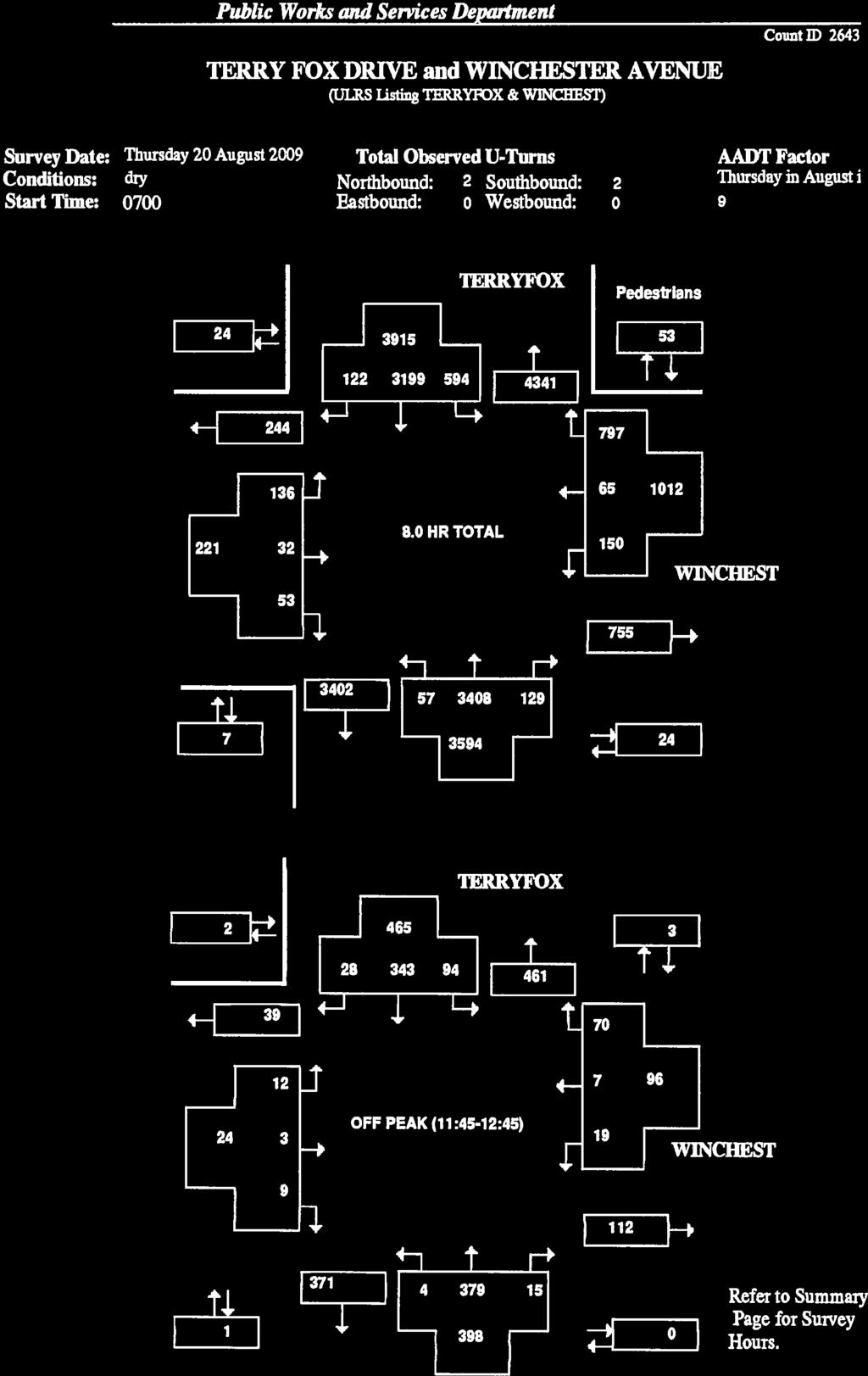
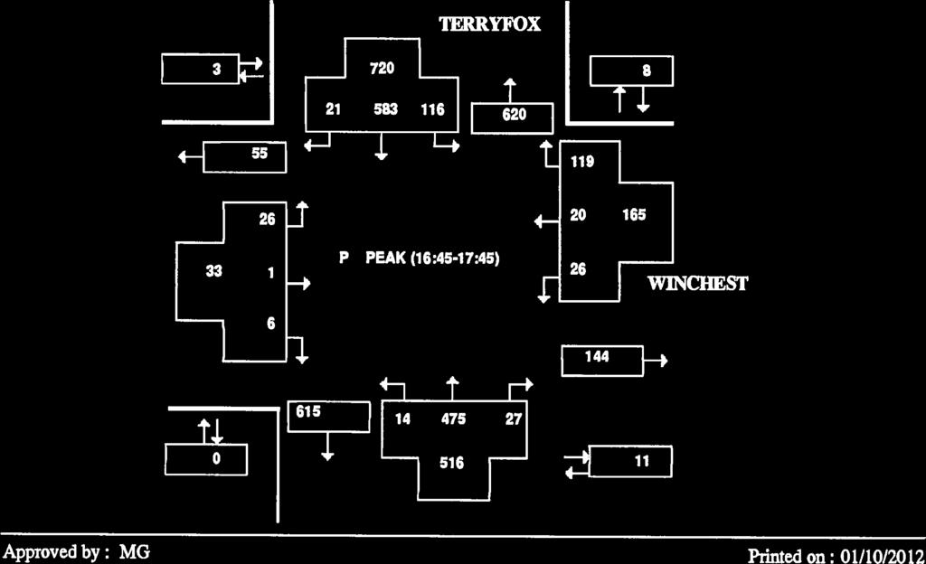
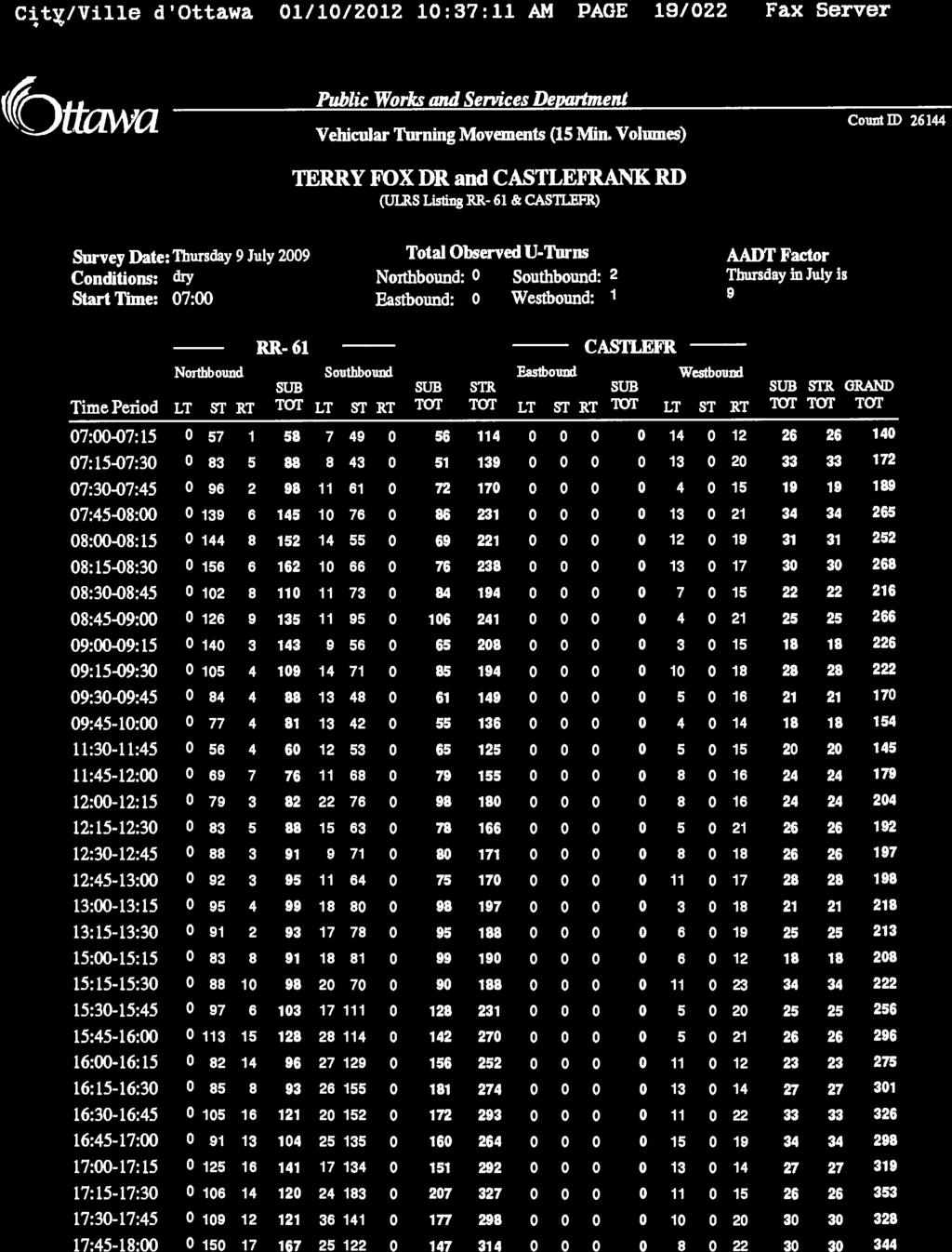
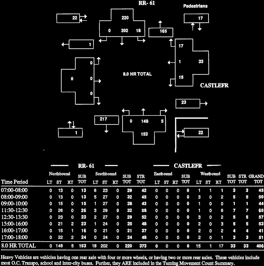
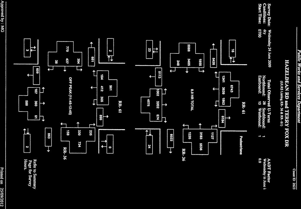
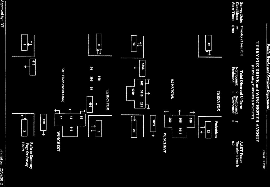
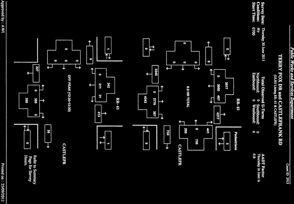
10 570 HAZELDEAN ROAD, OTTAWA, ON TRANSPORTATION BRIEF MARCH EXISTING TRANSPORTATION CONDITIONS 2.1 ROADS AND TRAFFIC CONTROL The major roadways in the study area are described below: Hazeldean Road a four lane arterial road with a 60 km/h posted speed limit. At the intersection with Terry Fox Drive, Hazeldean Road has dual left turn lanes in the eastbound and westbound directions. Additionally, channelized right turn lanes are provided in the eastbound and westbound directions. Terry Fox Drive a four lane arterial road with a 60 km/h posted speed limit. At the intersection with Hazeldean Road, Terry Fox Drive has dual left turn lanes in the northbound and southbound directions. Additionally, channelized right turn lanes are provided in the northbound and southbound directions. Approximately 350m north of Castlefrank Road, Terry Fox Drive narrows from a four lane cross-section to a two lane cross-section. Castlefrank Road is a two lane major collector road with a 40 km/h posted speed limit. This road will meet the future access onto Terry Fox Drive for the Fernbank Community. The west leg will serve as one of the site accesses to the Fernbank Community. At the intersection with Terry Fox Drive left turn lanes exist on the southbound and westbound legs. The northbound leg has been constructed such that implementing a left turn lane will not require additional pavement, the existing asphalt surface can be repainted to accommodate this modification. Right turn lanes are not provided on any leg of the intersection. Winchester Drive / Halkirk Avenue is a two lane collector road with a 50 km/h unposted speed limit. This intersection serves as an access to the communities east and west of Terry Fox Drive, between Hazeldean Road and Castlefrank Road. The road classifications noted above are referenced from Map 6 of the City of Ottawa s Transportation Master Plan (TMP). Figure 3 illustrates the existing lane geometry and traffic controls at the study area intersections. ml w:\active\ _fernbankdraftplancommunitytransportationstudy\reports\fernbank tb - final222.docx 2.5
11 570 HAZELDEAN ROAD, OTTAWA, ON TRANSPORTATION BRIEF MARCH 2013 Figure 3 Existing Intersection Configuration ml w:\active\ _fernbankdraftplancommunitytransportationstudy\reports\fernbank tb - final222.docx 2.6

12 570 HAZELDEAN ROAD, OTTAWA, ON TRANSPORTATION BRIEF MARCH TRANSIT Transit service is provided throughout the Study Area. The existing transit network includes routes along Terry Fox Drive, Hazeldean Road and throughout the community to the east of Terry Fox Drive. Nearby routes include: Route 96 Route 201 Route 203 In addition to utilizing the adjacent road network, Route 96 passes through the Fernbank Community via Shea Road. Hazeldean Road and Shea Road are designated as transitway links. Figure 4 illustrates the local transit routes. Figure 4 Study Area Transit Routes Subject Site Source: OC Transpo System Map, Accessed October 29, 2012 ( ml w:\active\ _fernbankdraftplancommunitytransportationstudy\reports\fernbank tb - final222.docx 2.7

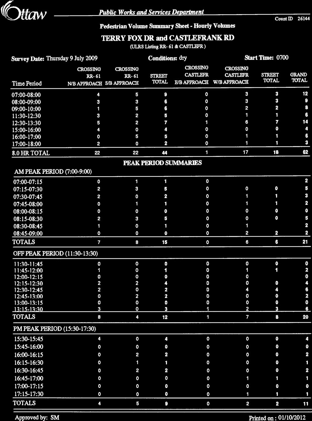
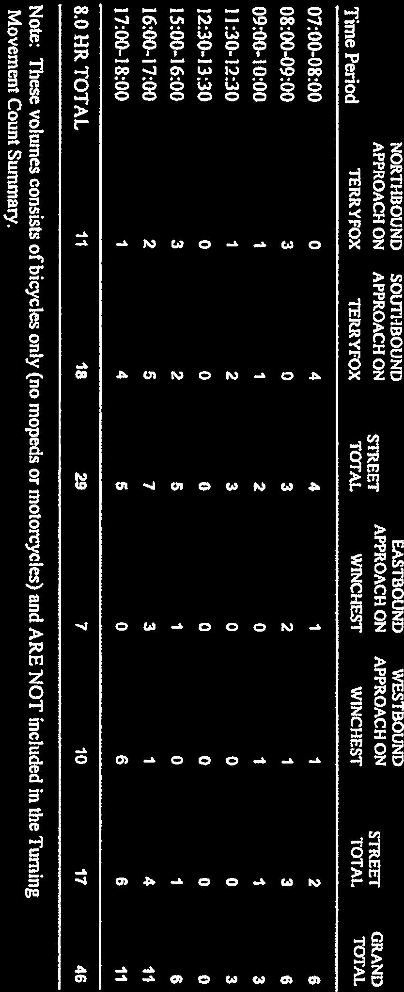
13 570 HAZELDEAN ROAD, OTTAWA, ON TRANSPORTATION BRIEF MARCH CYCLING AND WALKING The Study Area contains many existing cycling and pedestrian facilities. The Trans Canada Trail bi-sects the site and follows a city-owned multi-use pathway that runs along an existing hydro corridor. The Trans Canada Trail is a major east-west connection in the City s active transportation network. In addition to this facility, on-road cycling facilities are provided on Terry Fox Drive, along Hazeldean Road and paved shoulders are provided on Shea Road. Figure 5 details the existing study area cycling network and Figure 6 illustrates the existing and planned pedestrian network in the study area. Figure 5 Existing Cycling Network Subject Site Source: Ottawa Cycling Plan, January 2008 ml w:\active\ _fernbankdraftplancommunitytransportationstudy\reports\fernbank tb - final222.docx 2.8

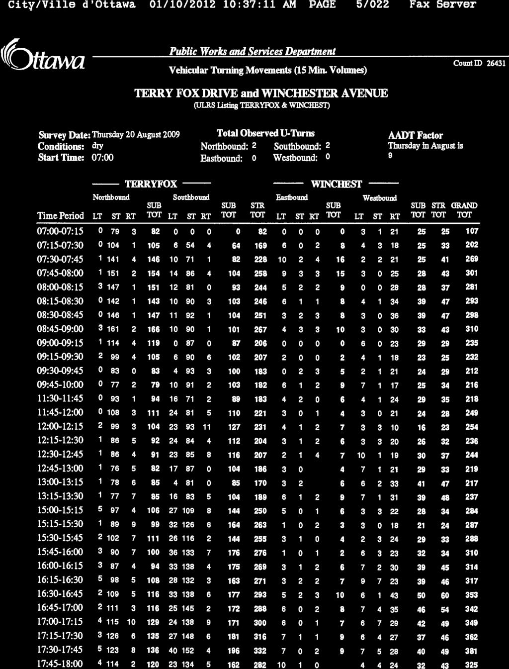
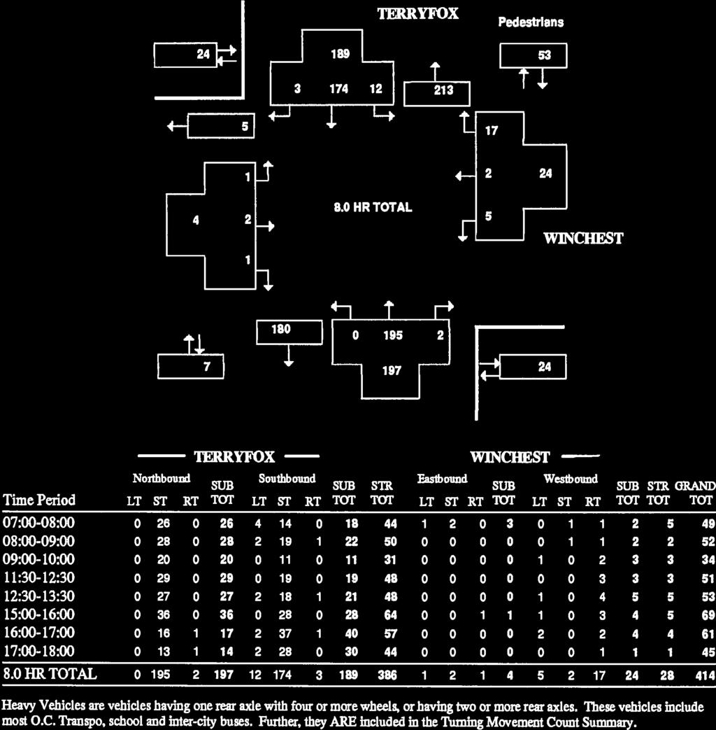
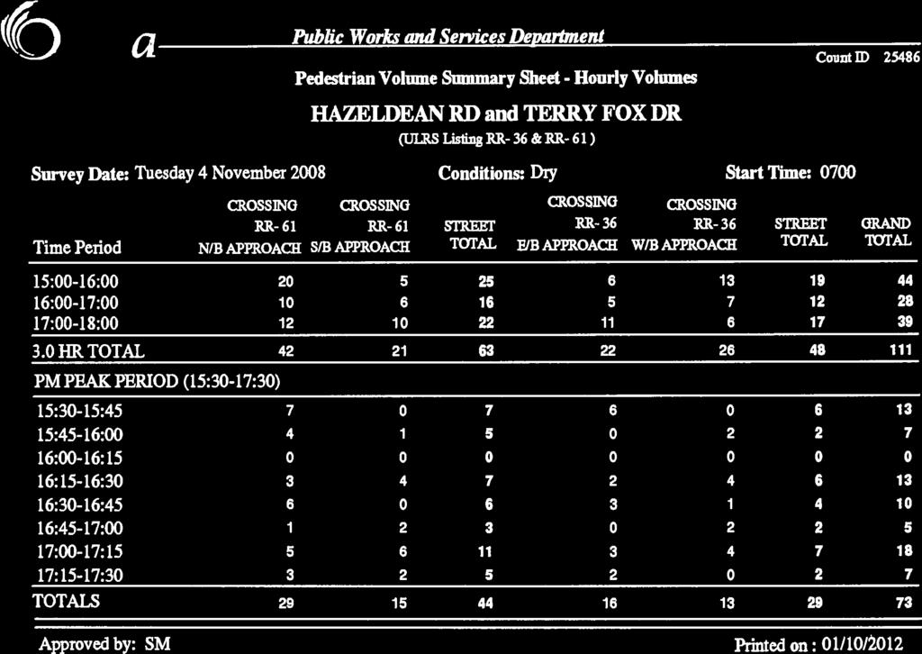
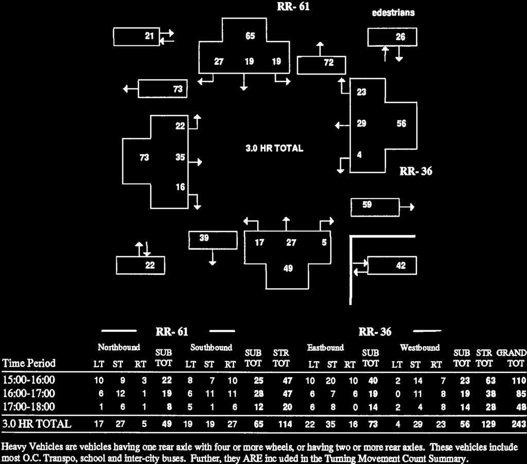
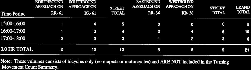
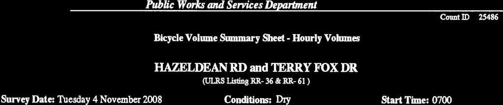
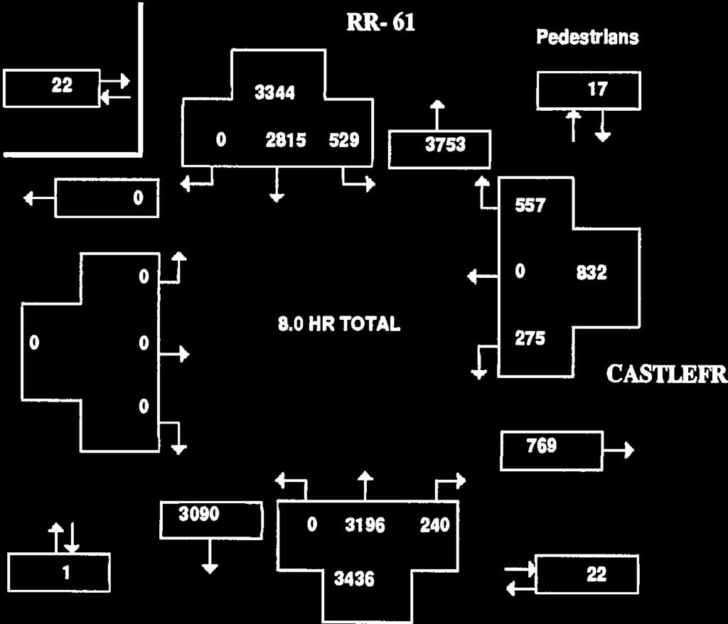
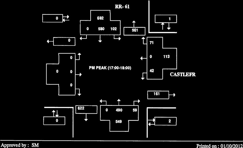
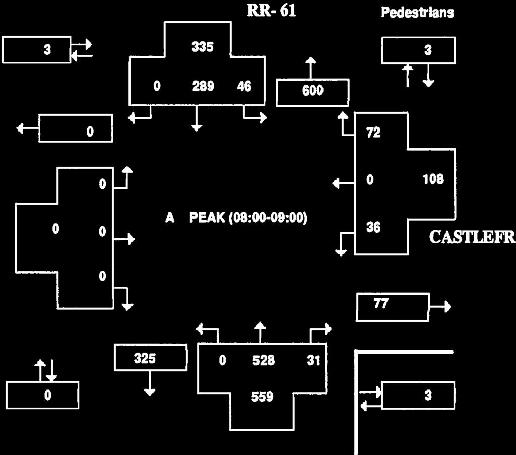
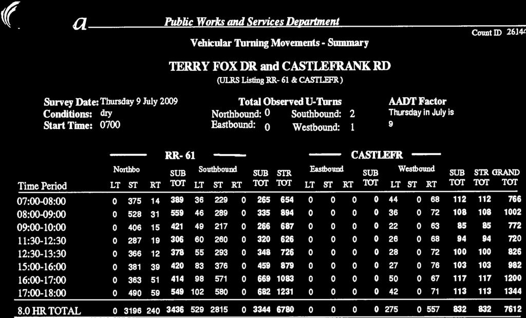
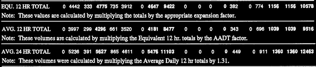
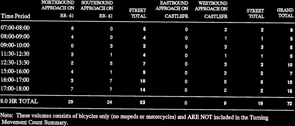
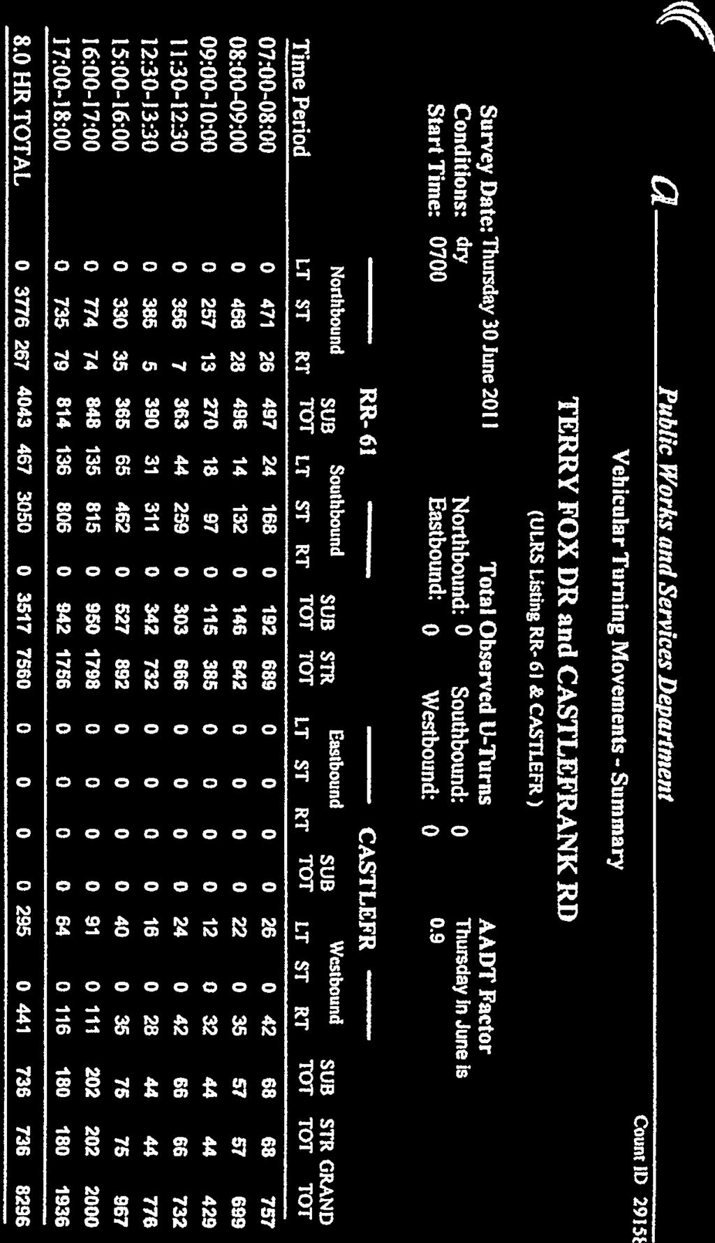
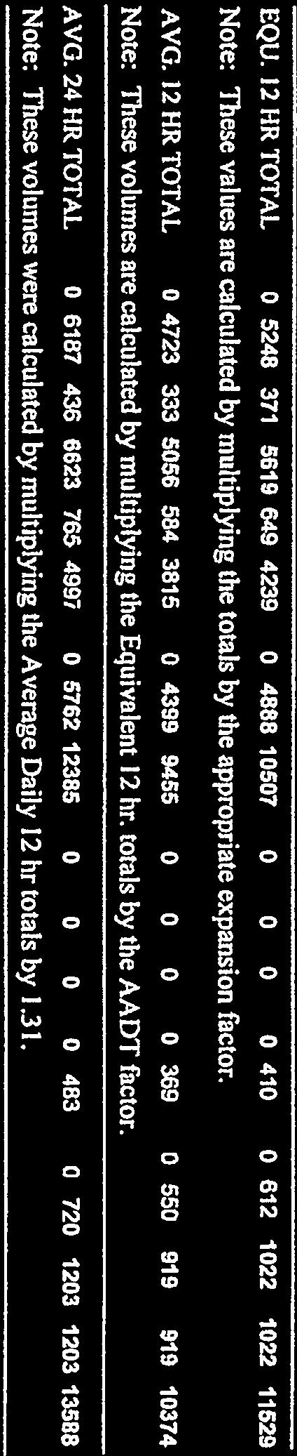
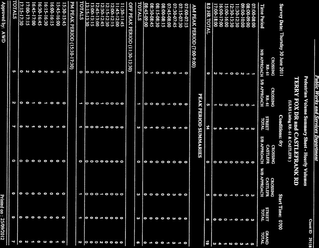
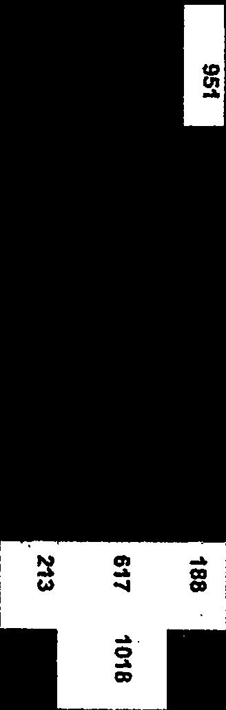
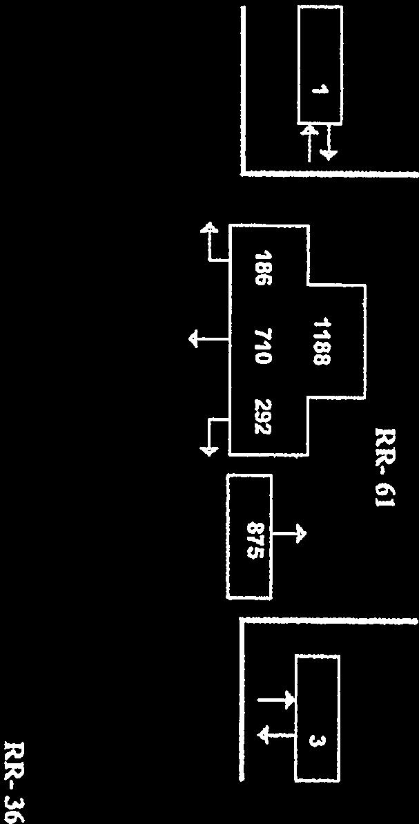
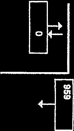
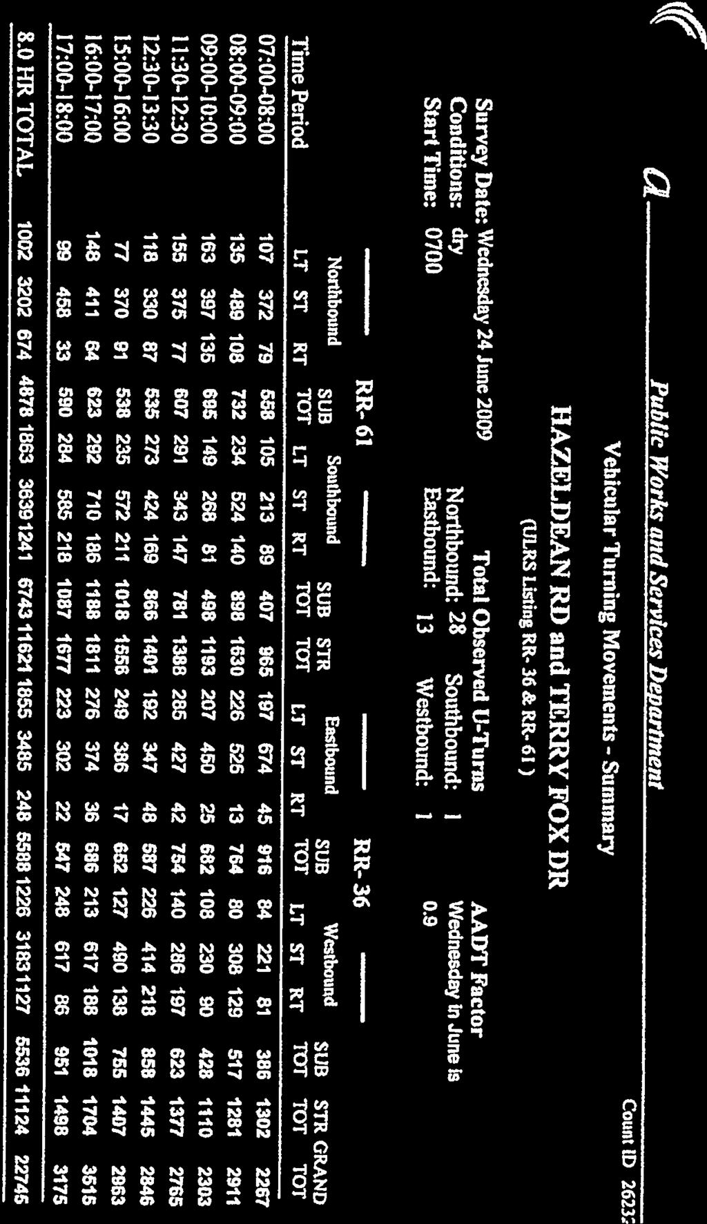
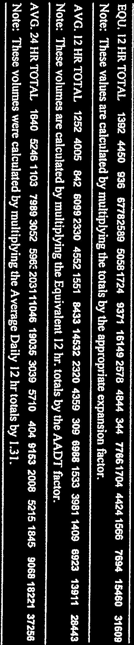
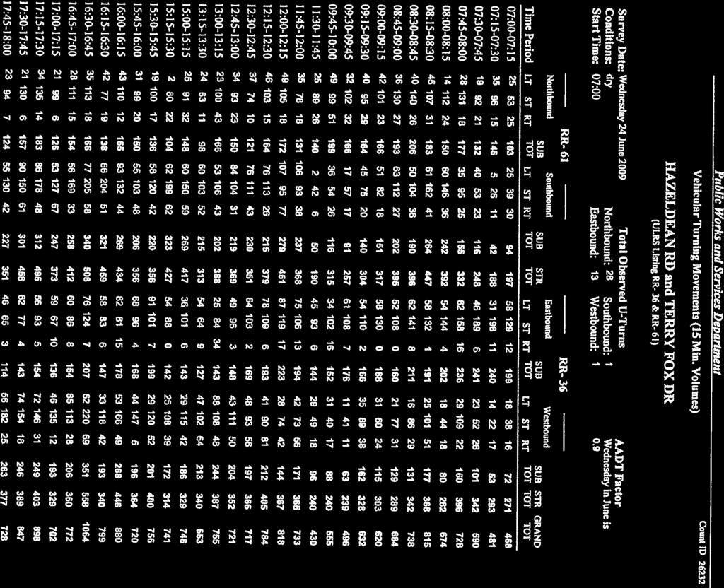
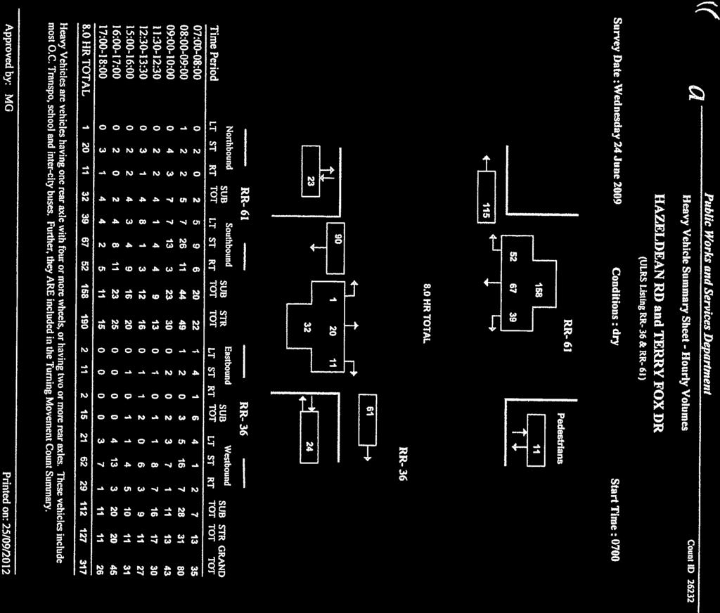
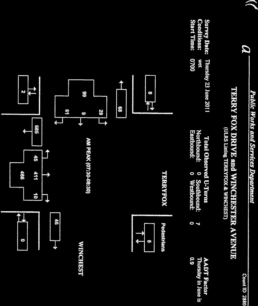
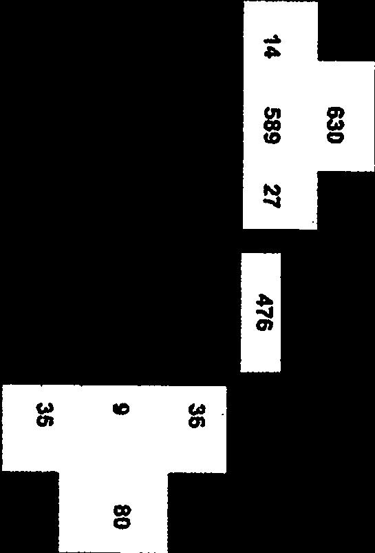
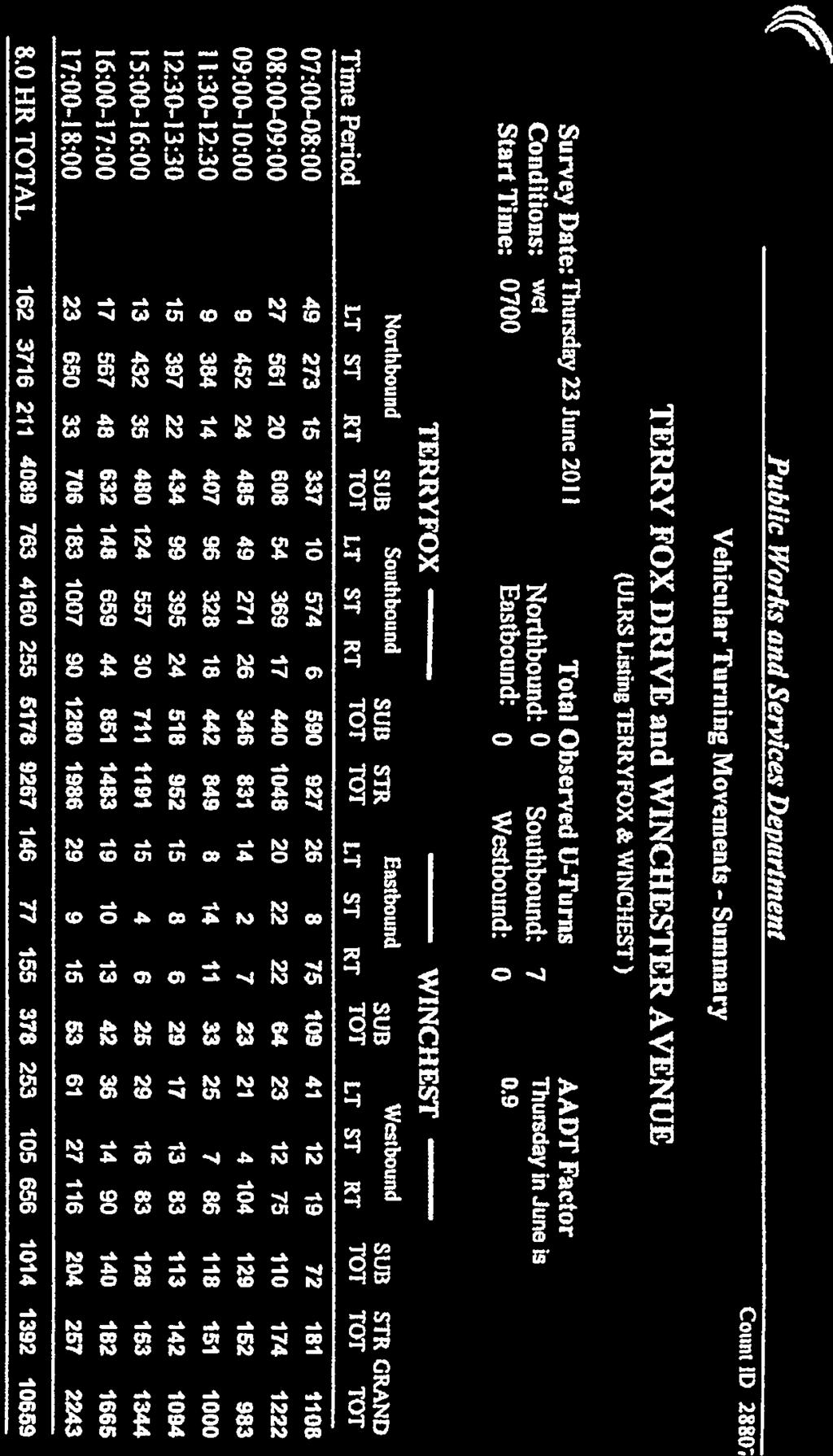
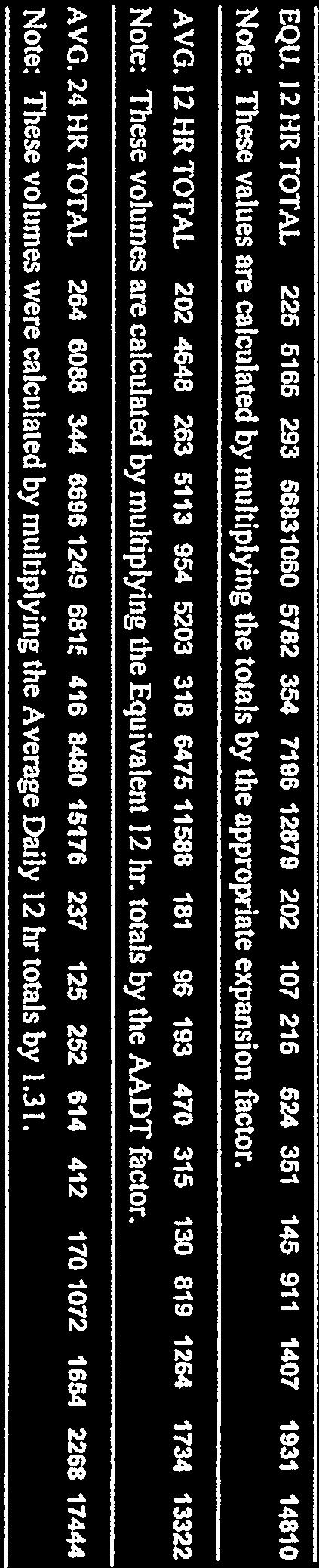
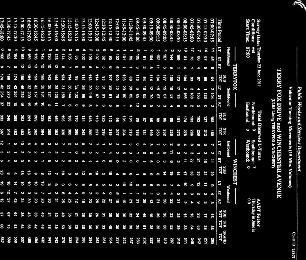
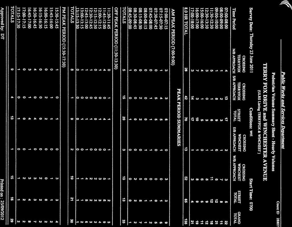
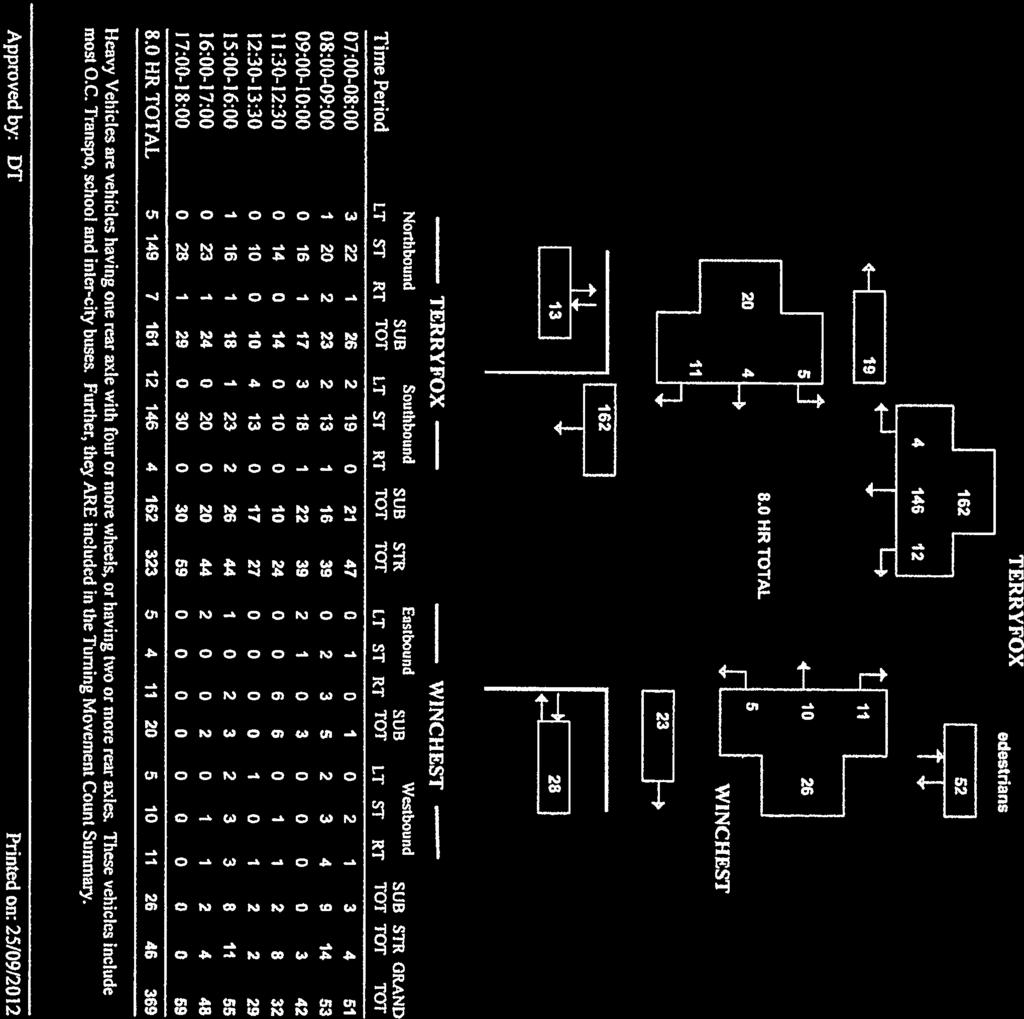
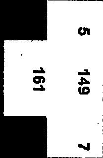
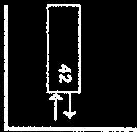
14 570 HAZELDEAN ROAD, OTTAWA, ON TRANSPORTATION BRIEF MARCH 2013 Figure 6 Existing and Planned Pedestrian Network Subject Site Source: Ottawa Cycling Plan, January TRAFFIC VOLUMES AND MAJOR TRIP GENERATORS Turning movement count surveys were provided by the City of Ottawa. Data was acquired from the two most recent surveys at the following intersections: Terry Fox Drive and Hazeldean Road Terry Fox Drive and Winchester Drive Terry Fox Drive and Castlefrank Road ml w:\active\ _fernbankdraftplancommunitytransportationstudy\reports\fernbank tb - final222.docx 2.9
15 570 HAZELDEAN ROAD, OTTAWA, ON TRANSPORTATION BRIEF MARCH 2013 The Fernbank Community is surrounded to the east, west and north by partially or fully developed communities. To the east is Glen Cairn, to the north are the Kanata West communities and to the west is Stittsville. The current urban boundary runs along Fernbank Road and, as such, there are no developments anticipated to occur south of the study area. As there are only a few accesses between the study area intersections, traffic volumes were balanced to maintain a logical traffic flow through the Study Area. All balancing was performed in a manner that favoured increasing volumes over decreasing volumes and, as a result, created a conservative estimate of the traffic volumes. Furthermore, existing turning movement count data that was collected prior to 2012 was adjusted to the current base year (2012) using a two percent per annum growth rate. Figure 7 details existing AM and PM peak hour traffic volumes at the study area intersection. The City s traffic data is provided for reference in Appendix A. Through this examination it was determined that the study area intersections do not exhibit traffic volumes that would warrant implementation of intersection upgrades in the form of additional turning lanes. As part of the detailed engineering design process, future transportation impact studies will include detailed intersection analysis which will determine if upgrades are required at any of the study area intersections to address capacity, delay, or storage constraints. City of Ottawa parameters for implementing upgrades at the Study Area intersections were applied to determine if improvements may be required. ml w:\active\ _fernbankdraftplancommunitytransportationstudy\reports\fernbank tb - final222.docx 2.10
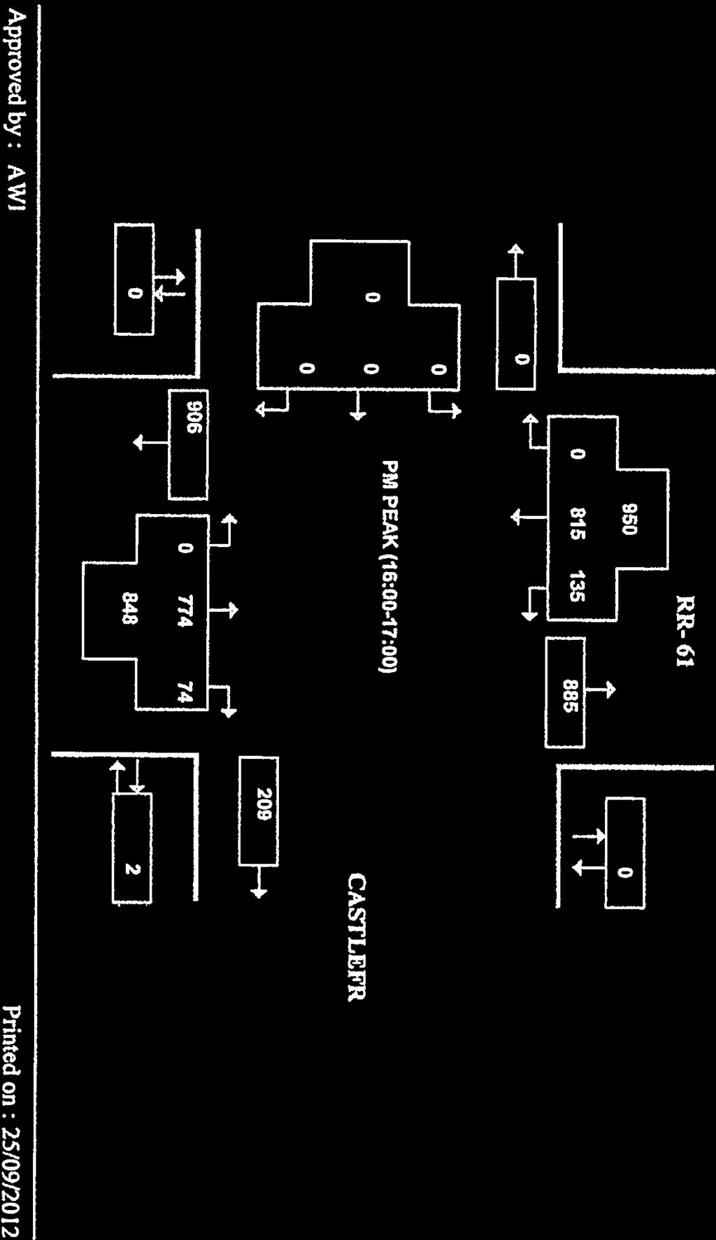
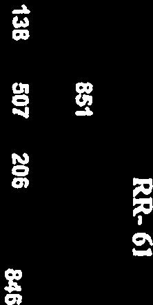
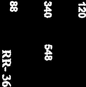
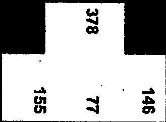
16 570 HAZELDEAN ROAD, OTTAWA, ON TRANSPORTATION BRIEF MARCH 2013 Figure Existing Traffic Volumes ml w:\active\ _fernbankdraftplancommunitytransportationstudy\reports\fernbank tb - final222.docx 2.11
17 570 HAZELDEAN ROAD, OTTAWA, ON TRANSPORTATION BRIEF MARCH FUTURE TRANSPORTATION CONDITIONS 3.1 HORIZON YEARS AND DEVELOPMENT PHASING Development of the Fernbank Community has been assumed to proceed at a rate of 500 units / year starting in 2015 and continuing until full build-out is achieved by This is consistent with the rate of development assumed in the Fernbank CDP Transportation Master Plan. In terms of the Mattamy site at 570 Hazeldean Road, construction has been assumed to commence in 2015 with the site fully built and occupied by Utilizing the build rate of 500 units / year it was determined that approximately 30% of the other lands within the Fernbank Community would be completed by the site build-out horizon of By 2026, or five years beyond site build-out, 55% of the other lands within the Fernbank Community were assumed to be built with the remaining areas developing by The following future transportation horizons, therefore, have been examined: 2021 future background conditions; 2021 total future conditions (site 100% built; other areas of Fernbank Community 30% built); and 2026 future horizon (5-years beyond site build-out; other areas of Fernbank Community 55% built) 3.2 MODE SHARE ASSUMPTIONS The TRANS Committee s 2005 Origin-Destination (O-D) Survey for the National Capital Region was reviewed to ascertain the existing mode share characteristics of the Kanata / Stittsville traffic zone. The existing mode share characteristics of the Kanata / Stittsville traffic zone were then compared and adjusted to be consistent with the future mode share projections of the Fernbank CDP Transportation Master Plan. Table 1 summarizes the mode share assumptions (future conditions) applied in this study. Table 1 Future Mode Share Assumptions Mode AM PM Auto 47% 57% Passenger 17% 15% Transit 30% 25% Active Mode 6% 3% ml w:\active\ _fernbankdraftplancommunitytransportationstudy\reports\fernbank tb - final222.docx 3.12

18 570 HAZELDEAN ROAD, OTTAWA, ON TRANSPORTATION BRIEF MARCH TRAFFIC FORECASTS Transportation Model A transportation model of the Fernbank Community was developed with the future community divided into several traffic zones that followed a logical pattern of physical features (i.e. hydro corridor), primary roads (i.e. planned arterials and collectors) and proposed intersections along the boundary road network. The traffic zones were established in order to allocate / assign traffic volumes to the study area intersections. Figure 8 shows the 8 distinct traffic zones established as part of the transportation model. In total 20 properties featuring 300 ha of developable land and 9645 residential units were accounted for. Mattamy s 570 Hazeldean Road is represented by traffic zones N4 and N5. Figure 8 Fernbank Community Traffic Zones Fernbank Community Traffic Forecasts / Generation The Fernbank Community is a large development area (approximately 670 ha), of which, 570 Hazeldean represents only a small portion. The land uses and residential units contained within each of the traffic zones is based on Schedule A-3 from the Core Services Agreement prepared by Novatech and is attached in Appendix B. ml w:\active\ _fernbankdraftplancommunitytransportationstudy\reports\fernbank tb - final222.docx 3.13
19 570 HAZELDEAN ROAD, OTTAWA, ON TRANSPORTATION BRIEF MARCH 2013 The Institute of Transportation (ITE) Trip Generation Manual (9 th Edition) was used to estimate traffic generated by the entire Fernbank Community including the subject site. Table 2 summarizes the ITE land use categories and trips rates obtained from the ITE Trip Generation Manual. Land Use Table 2 ITE Land Use Categories and Trip Rates Units Morning Peak Hour Afternoon Peak Hour Inbound Outbound Total Inbound Outbound Total Single Family Detached (210) Residential Condominium / Townhouse (230) Mixed Use (230) High Density (220) Table 3 summarizes the traffic generated by the Fernbank Community by traffic zone including the subject Mattamy site. As shown in Table 3, at a build rate of 500 units per year commencing in 2015, the 9,645 residential units planned for the Fernbank Community are expected to generate over 8,000 person trips during the AM peak hour and over 10,000 person trips during the PM peak hour. In addition, the Fernbank Community will generate roughly 3,800 automobile trips during the morning peak hour and roughly 5,900 automobile trips during the PM peak hour. In terms of the Mattamy component, with roughly 600 residential units the site is expected to generate approximately 500 person trips during the AM peak hour and roughly 630 person trips during the PM peak hour. Similarly, the site is expected to generate 230 automobile trips during the AM peak hour and approximately 360 automobile trips during the PM peak hour. Overall, in terms of number of units and number of trips, the Mattamy development represents roughly 6% of the Fernbank Community. ml w:\active\ _fernbankdraftplancommunitytransportationstudy\reports\fernbank tb - final222.docx 3.14
20 570 HAZELDEAN ROAD, OTTAWA, ON TRANSPORTATION BRIEF MARCH 2013 Zone Modes Split N1 N2 N3 N4 (Mattamy) N5 (Mattamy) S1 S2 Table 3 Fernbank Community Traffic Generation Morning Peak Hour Afternoon Peak Hour Split In Out Total In Out Total Auto 47% % Passenger 17% % Transit 30% % Active Modes 6% % N1 Subtotal 100% % Auto 47% % Passenger 17% % Transit 30% % Active Modes 6% % N2 Subtotal 100% % Auto 47% % Passenger 17% % Transit 30% % Active Modes 6% % N3 Subtotal 100% % Auto 47% % Passenger 17% % Transit 30% % Active Modes 6% % N4 Subtotal 100% % Auto 47% % Passenger 17% % Transit 30% % Active Modes 6% % N5 Subtotal 100% % Auto 47% % Passenger 17% % Transit 30% % Active Modes 6% % S1 Subtotal 100% % Auto 47% % Passenger 17% % Transit 30% % Active Modes 6% % ml w:\active\ _fernbankdraftplancommunitytransportationstudy\reports\fernbank tb - final222.docx 3.15
21 570 HAZELDEAN ROAD, OTTAWA, ON TRANSPORTATION BRIEF MARCH 2013 S2 Subtotal 100% % Auto 47% % Passenger 17% % S3 Transit 30% % Active Modes 6% % S3 Subtotal 100% % Mattamy Totals 2021 Background Trips (30% Total) 2026 Background Trips (55% Total) 2034 Background Trips (100% Total) Grand Total Auto 47% % Passenger 17% % Transit 30% % Active Modes 6% % Mattamy Subtotal 100% % Auto 47% % Passenger 17% % Transit 30% % Active Modes 6% % Background Subtotal 100% % Auto 47% % Passenger 17% % Transit 30% % Active Modes 6% % Background Subtotal 100% % Auto 47% % Passenger 17% % Transit 30% % Active Modes 6% % Background Subtotal 100% % Auto 47% % Passenger 17% % Transit 30% % Active Modes 6% % Grand Total 100% % ml w:\active\ _fernbankdraftplancommunitytransportationstudy\reports\fernbank tb - final222.docx 3.16
22 570 HAZELDEAN ROAD, OTTAWA, ON TRANSPORTATION BRIEF MARCH TRAFFIC DISTRIBUTION AND ASSIGNMENT The distribution of traffic to/from the Fernbank Community was determined through examination of the TRANS Committee s 2005 Origin-Destination (O-D) Survey. Table 4 provides a summary of the distribution of traffic from the Kanata / Stittsvile traffic zone across the four cardinal directions. Additionally, the Kanata / Stittsville traffic zone was found to contain a large percentage of internal trips (i.e. trips that do not leave the Kanata / Stittsville traffic zone). To reflect this, the district-level traffic zones (i.e. sub-zones) within the Kanata / Stittsville traffic zone were examined and the trip distribution was adjusted accordingly and is reflected in Table 4. Table 4 Traffic Distribution from the Kanata / Stittsville Traffic Zone Cardinal Direction Assignment North 35% South 5% East 55% West 5% Appendix C provides a more detailed summary of the trip distribution and assignment. Site trips were assigned to the road network based on the location of each zone relative to the proximity of planned collector and arterial roads and proposed intersections along the boundary road network. Figure 9 illustrates the assignment of site traffic to the boundary road network and study area intersections. ml w:\active\ _fernbankdraftplancommunitytransportationstudy\reports\fernbank tb - final222.docx 3.17
23 570 HAZELDEAN ROAD, OTTAWA, ON TRANSPORTATION BRIEF MARCH 2013 Figure 9 Site Traffic Assignment ml w:\active\ _fernbankdraftplancommunitytransportationstudy\reports\fernbank tb - final222.docx 3.18
24 570 HAZELDEAN ROAD, OTTAWA, ON TRANSPORTATION BRIEF MARCH FUTURE BACKGROUND CONDITIONS Future background conditions are assessed to determine transportation improvements that may be required to address growth in traffic exclusive from improvements that may be required to accommodate traffic generated by the subject development. Any improvements identified to address future background conditions are not the responsibility of the developer. Future background conditions are typically derived by calculating the annual rate of growth on a transportation facility through a review of historic traffic volumes and / or by accounting for traffic generated by other known area developments that were recently approved or that are currently in the planning approvals process. A growth rate of 2% annually was applied to existing traffic volumes at the study area intersections until the 2021 future horizon. This rate of traffic growth is consistent with the background rate of growth assumed in the Fernbank Community Design Plan TMP. In addition, the trips generated by the other areas of the Fernbank Community (i.e. all areas excluding the subject Mattamy site) were added to the boundary road network. By 2021, at a build rate of 500 units per year, approximately 30% of the other areas of the Fernbank Community will have been built. In assessing future background conditions, currently planned road network improvements must also be considered. The City s TMP identifies the widening of Terry Fox Drive (from two to four lanes) from Winchester Drive to Eagleson Road at Hope Side Road as a Phase 2 project (i.e ). Figure 10 illustrates 2021 future background traffic volumes at the study area intersections. The Fernbank Community Design Plan shows a demonstration plan which features a roundabout located within Mattamy s proposed development. The roundabout occurs at an intersection of two internal collector roads. The east/west collector road ultimately extends through the roundabout and intersects with Terry Fox Drive opposite Castlefrank Road forming a new west leg of the Terry Fox Drive / Castlefrank Road intersection. At the time of implementation of this new leg (i.e. new access) it is logical to replace the painted-out median on the south leg, which currently balances the existing lane geometry by shadowing the southbound left turn lane, with an exclusive northbound left turn lane that will facilitate access to the Fernbank Community. The length of the storage and taper for the northbound left turn lanes will be determined through subsequent Traffic Impact Studies (TIS s) that will be submitted for each development phase. An exclusive southbound right turn lane is not anticipated to be required at Terry Fox Drive / Castlefrank Road intersection as the projected volume of right turning vehicles does not fall within 10 to 20 percent of the advancing southbound volumes. The newly formed west leg of the intersection should be configured to accommodate an exclusive eastbound left turn lane and a shared through / right turn lane. Traffic volumes at the internal roundabout intersection can be accommodated with a single lane roundabout. Additionally, during the detailed engineering design process, intersection capacity analysis will be performed which will determine what, if any, upgrades will be necessary to address capacity, delay or storage constraints. No other improvements are anticipated to be required at any of the remaining study area intersections. ml w:\active\ _fernbankdraftplancommunitytransportationstudy\reports\fernbank tb - final222.docx 3.19
25 570 HAZELDEAN ROAD, OTTAWA, ON TRANSPORTATION BRIEF MARCH 2013 Figure Future Background Traffic Volumes ml w:\active\ _fernbankdraftplancommunitytransportationstudy\reports\fernbank tb - final222.docx 3.20
26 570 HAZELDEAN ROAD, OTTAWA, ON TRANSPORTATION BRIEF MARCH TOTAL FUTURE CONDITIONS Total future conditions are examined to determine improvements that are required as a direct result of the development of the site. By 2021, all 600 residential units within Mattamy s proposed development are anticipated to be built and occupied. Total future traffic volumes are derived by adding site generated trips (Figure 9) to future background volumes (Figure 10) anticipated for Figure 11 illustrates 2021 total future traffic volumes at the study area intersections. As noted in Section 3.5, the newly created fourth leg (west leg) of the Terry Fox Drive / Castlefrank Road intersection will not only provide access to the entire Fernbank Community but it will also act as a primary access to the subject site. By the 2021 total future horizon, and with the addition of site trips to the Terry Fox Drive / Castlefrank Road intersection, the volume of southbound right turning vehicles falls within the 10 to 20 percent range of advancing volumes where an exclusive right turn lane should be considered. Given that detailed intersection performance is not part of this TB, the need for an exclusive southbound right turn lane at this intersection will be confirmed through subsequent TIS s that will be submitted for each development phase. Traffic volumes at the internal roundabout intersection can be accommodated with a single lane roundabout. Additionally, during the detailed engineering design process, intersection capacity analysis will be performed which will determine what, if any, additional upgrades may be necessary to address capacity, delay or storage constraints. Figure 12 illustrates the future lane geometry and traffic control anticipated to be required by No other improvements are anticipated to be required at any of the remaining study area intersections as a direct result of the proposed development FUTURE CONDITIONS (5 YEARS BEYOND SITE BUILD-OUT) By 2026, the study area road network will have undergone significant changes through major infrastructure projects that will influence the distribution of local traffic in significant ways. These major infrastructure projects include: Two to four lane expansion of Terry Fox Drive, south of Winchester Drive (TMP Phase ) Extension of the Fernbank Community s north-south arterial from Hazeldean Road to the Palladium Road / Highway 417 Interchange (TMP Phase 3 - beyond 2022) Implementation of the Hope Side Road Extension to the 416 (TMP Phase 2 or potentially Phase 3 due to delays in the EA process) Due to the vague timing of some of these projects, as well as the relative unpredictable nature of predicting their influence on future traffic patterns, this TB did not explicitly attempt to quantify conditions in Predicting the implications of these projects is more appropriately addressed at a City-wide level through the preparation of Transportation Master Plans or Secondary Plans. ml w:\active\ _fernbankdraftplancommunitytransportationstudy\reports\fernbank tb - final222.docx 3.21
27 570 HAZELDEAN ROAD, OTTAWA, ON TRANSPORTATION BRIEF MARCH 2013 Figure Total Future Traffic Volumes ml w:\active\ _fernbankdraftplancommunitytransportationstudy\reports\fernbank tb - final222.docx 3.22
28 570 HAZELDEAN ROAD, OTTAWA, ON TRANSPORTATION BRIEF MARCH 2013 Figure Future Intersection Configuration ml w:\active\ _fernbankdraftplancommunitytransportationstudy\reports\fernbank tb - final222.docx 3.23
29 570 HAZELDEAN ROAD, OTTAWA, ON TRANSPORTATION BRIEF MARCH 2013 It is noted that the Fernbank Community Design Plan TMP has shown that with the improvements identified in the TMP that capacity across the Hazeldean Road screenline will be sufficient to accommodate the build-out of the Fernbank Community. Furthermore, transportation conditions for the 2026 horizon (5 years beyond site build-out) will be assessed in future TISs prepared at the detailed engineering design stage. 3.8 TRANSIT SERVICE In order to achieve the citywide 30% modal split targets, transit needs to be accommodated as an integral part of the community structure from the outset of development. The interim transit service provisions for the Fernbank Community are outlined in the Fernbank Community Design Plan and are summarized below. During early stages of the development of the entire Fernbank community, transit service will be provided along the arterial and collector roadways as they are phased into the development. During the interim, until a more continuous network of roads is developed, existing routes from surrounding communities in Kanata could be rerouted to service the developing areas of Fernbank including Mattamy s proposed development. It is recommended that Mattamy and the City enter into an early transit service agreement. The cost to provide the transit service would be paid by the developer until such time that the number of units occupied reaches a ridership level which can be sustained by the City in order to meet the minimum financial performance standard. The long-term ultimate transit route network would likely feature two local routes providing service to the Fernbank community and connecting the community with the Stittsville, Kanata West and Kanata communities. One route would provide service in the north-south direction in the eastern portion of the community while the other route would provide service in the east-west direction through the middle of the community. Furthermore, a Transitway route will be provided along the main north/south arterial. 3.9 ACTIVE MODES The Fernbank CDP reinforces the City of Ottawa s desire to encourage cycling and walking as viable transportation modes. The existing TransCanada Trail bisects the Fernbank community in an east-west direction and runs just south of the Mattamy development. The trail will continue to function as a major multi-use pathway serving the West Urban Community as a whole. Site plan provisions should allow for direct connections to be made to the trail wherever possible. The CDP also identifies off road pathways within the hydro corridor to the south of Mattamy s development as well as off road pathways within the Glen Cairn Stormwater facility to the east. Direct connections to these facilities should be accommodated within the site plan. ml w:\active\ _fernbankdraftplancommunitytransportationstudy\reports\fernbank tb - final222.docx 3.24
30 570 HAZELDEAN ROAD, OTTAWA, ON TRANSPORTATION BRIEF MARCH 2013 In addition, sidewalks should be provided on both sides of arterial and collector roads and, where deemed appropriate, on one side of local roads COMMUNITY IMPACTS The Fernbank Community will utilize land that was previously utilized for agricultural purposes. Developing this land will create connections between the communities to the east and west of the Fernbank Community. Additionally, a new north south arterial link will be created that will also provide for a new dedicated transit link. These new facilities will provide capacity and connectivity for both the existing and new traffic in the Study Area. The completion of this community will provide the opportunity to complete transit, cycling and pedestrian links for the existing communities. Impacts to the surrounding communities will only occur on the arterial roads. Cut-through traffic from the Fernbank Community to the surrounding communities will be minimal, as commuters will be drawn to the arterial road system TRANSPORTATION DEMAND MANAGEMENT This development has been planned, through the CDP process, to accommodate transit and active transportation modes. This will offer the residents a variety of commuting opportunities. The CDP shows a transit station in the north, middle and south of the property, along the proposed transit corridor. The opportunity also exists for many local transit connections to be made throughout the community. It will require consultation with OC Transpo to determine the required routing and number of buses to be used throughout the community. As the proposed development is a residential subdivision no further Transportation Demand Management initiatives have been investigated or are being planned. ml w:\active\ _fernbankdraftplancommunitytransportationstudy\reports\fernbank tb - final222.docx 3.25
31 570 HAZELDEAN ROAD, OTTAWA, ON TRANSPORTATION BRIEF MARCH SUMMARY AND CONCLUSIONS The Transportation Brief has found the following: Mattamy s proposed development at 570 Hazeldean Road is ha in size and will feature approximately 600 residential units split fairly equally between single detached and townhouse dwelling units. Construction is anticipated to commence by 2015 and be completed by The proposed development is expected to generate approximately 500 person trips during the AM peak hour and roughly 630 person trips during the PM peak hour. Similarly, the site is expected to generate 230 automobile trips during the AM peak hour and approximately 360 automobile trips during the PM peak hour. Overall, in terms of number of units and number of trips, the Mattamy development represents roughly 6% of the Fernbank Community which will contain approximately 9,645 residential units. Primary access to the proposed development will be achieved at the Terry Fox Drive and Castlefrank Road intersection where a new leg (west leg) will be created. Under existing conditions the intersections in the study area do not exhibit any characteristics that would indicate that immediate upgrades are necessary. The study area is well served by transit and there are good opportunities for cycling and walking trips using the existing road and sidewalk networks. By the 2021 future background horizon, it is recommended that the painted-out median on the south leg of the Terry Fox Drive / Castlefrank Road intersection be replaced by an exclusive northbound left turn lane in order to facilitate access to the Fernbank Community. The newly formed west leg of this intersection should be designed to accommodate an exclusive eastbound left turn lane and a shared through / right turn lane. No other improvements are anticipated to be required at any of the other study area intersections to accommodate 2021 future background conditions. During the 2021 future background horizon traffic volumes at the internal roundabout intersection can be accommodated with a single lane roundabout. By the 2021 total future horizon the volume of southbound right turning vehicles at the Terry Fox Drive / Castlefrank Road intersection will fall within the 10 to 20 percent range of advancing volumes where an exclusive right turn lane should be considered. Given that detailed intersection performance is not part of this TB, the need for an exclusive southbound right turn lane at this intersection will be confirmed through subsequent TIS s that will be submitted for each development phase. During the 2021 total future horizon traffic volumes at the internal roundabout intersection can be accommodated with a single lane roundabout. ml w:\active\ _fernbankdraftplancommunitytransportationstudy\reports\fernbank tb - final222.docx 4.26
32 570 HAZELDEAN ROAD, OTTAWA, ON TRANSPORTATION BRIEF MARCH 2013 By 2026, the study area road network will have undergone significant changes through major infrastructure projects that will influence the distribution of local traffic in significant ways. These major infrastructure projects include: o Two to four lane expansion of Terry Fox Drive, south of Winchester Drive (TMP Phase ) o o Extension of the Fernbank Community s north-south arterial from Hazeldean Road to the Palladium Road / Highway 417 Interchange (TMP Phase 3 - beyond 2022) Implementation of the Hope Side Road Extension to Highway 416 (TMP Phase 2 or potentially Phase 3 due to delays in the EA process) It is recommended that Mattamy and the City of Ottawa enter into an early transit service agreement. The cost to provide the transit service would be paid by the developer until such time that the number of units occupied reaches a ridership level which can be sustained by the City in order to meet the minimum financial performance standard. Provisions for active transportation modes have been well accounted for in the Fernbank CDP. Further site plan provisions should allow for direct connections to be made to the existing TransCanada Trail to the south and to the off road pathway within the Glen Gairn Stormwater facility to the east. In addition, sidewalks should be provided on both sides of arterial and collector roads and, where deemed appropriate, on one side of local roads. Based on the transportation evaluation and the impacts that have been anticipated in this study, the proposed development of 570 Hazeldean Road should be permitted to proceed to the next phase of the approvals process. This study is consistent with the findings of the Fernbank CDP Transportation Master Plan and the objectives of the City of Ottawa Transportation Master Plan. Further TIAs will be required once the registration of the site plan of each phase of the development commences. Rob Vastag, MCIP, RPP Project Manager Mark Crockford, Engineering Intern Traffic Analyst ml w:\active\ _fernbankdraftplancommunitytransportationstudy\reports\fernbank tb - final222.docx 4.27
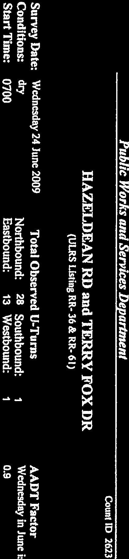
33 Appendix A Tuning Movement Count
34

35
36
37
38
39
40
41
42

43

44
45
46
47

48
49
50
51
52
53
54


55
56

57

58
59
60
61


62
63
64
65
66
67
68

69
70
71
72
73
74
75
76 Appendix B Core Services Agreement, Novatech
77 CORE SERVICES AGREEMENT - SCHEDULE A-3 Fernbank CDP Site Statistic Summary PIN ADDRESS OWNER GROSS AREA (ha) CONSTRAINT AREAS HYDRO EASEMENT FLOODPLAIN/ RIPARIAN OPEN SPACE NET AREA (ha) NET AREA (% BY TOTAL) NET AREA (% BY MAJOR LAND OWNERS) ROAD WIDENING PARKS SWM ARTERIAL ROAD TRANSIT/ PARAMEDIC INST. COMM. MIXED ROADS LOW DENSITY RESIDENTIAL MEDIUM HIGH DENSITY DENSITY RESIDENTIAL RESIDENTIAL UNITS DEDICATION (ha) REQ'D PARK CRT Development Inc % 25.47% Fernbank Rd Ontario Ltd % 19.80% Hazeldean Rd. Kizell Management Corporation % 16.57% Abbott-Fernbank Holdings Inc % 11.50% Hazeldean Rd Ontario Ltd % 8.56% Hazeldean Rd. Mattamy (Fernbank) Limited % 5.78% Fernbank Rd Ontario Ltd % 4.86% Hazeldean Rd. MVCA % Fernbank Rd Ontario Inc % 3.82% fronts on Terry Fox Dr. SPB Developments Inc % 2.07% Hazeldean Rd. Double Deck Golf Centre Ltd % fronts on Abbott St. City of Ottawa (Goulbourn TWP) % Fernbank Rd. Kanata Shopping Centres Limited % 1.58% Terry Fox Dr. City of Ottawa (Trans Canada Trail) % Fernbank Rd. R. & S. Stone % Fernbank Rd. D. & A. Jones % Fernbank Rd. D. Duncan, J. Richmond % City of Ottawa (Abbott Street Extension) % fronts on Terry Fox Dr. HEPC of Ontario % Kincardine Dr. Claridge Homes Inc % fronts on Fernbank Rd. Margard Builders ltd % fronts on Fernbank Rd. Margard Builders ltd % Hazeldean Rd N.Craig/B.McGee % Fernbank Rd. M. & W. Burnett % Fernbank Rd. M. & J. Hamel % Fernbank Rd. E. & D. Moore % Hazeldean Rd. K. Watson % Fernbank Rd. M. & G. Moore % City of Ottawa (Shea Road) % City of Ottawa (Hazeldean Road) % TOTAL % % Notes 1) Gross Area measured from the Demonstraton Plan using a Compiled Legal drawing (does not exactly match individual legal plans ) 2) Net Area = Gross Area - Constraint Areas (i.e. Hydro Easement + Flood Plain / Riparian Corridor + Open Space) 3) Overlapping Land Use: Constraint Areas are calculated before development land (Residential, Roads, Parks, SWM, ICI) 4) Linear Pathway areas (adjacent Stittsville and Pond 8) are designated Parks 5) CRT UNA Woodlot area is designated Low Density Residential land in this spreadsheet; it is assumed the land will be developed (i.e. City will NOT purchase this parcel). 6) Open Space parcels on the Cavanagh and Jones properties are allocated Low Density Residential as there is no development constraint. 7) Riparian corridor (Monahan, Hazeldean, Carp Tributary) constraint zones calculated per hatched area on Demonstration Plan. 8) Hydro Easement parallel Shea Rd: calculation of Net Area corrected for apparent error in location on Compiled Legal (affects CRT, Cavanagh and Jones) 9) Total Units calculated based on low end of density range in CDP: Units per Hectare are (Low Density=26, Medium Density=50, High Density=60, 50% of Mixed Use=80) Oct.13/09: Del Lands, Corrected Area of Transit (Park n' Ride) from 2.80ha to 2.48ha Mar.16/10: CRT Developments Inc. purchased land from Brookfield May 27/10: SmartCentres Land purchased from Van Gaal Jun. 2/10: SmartCentres purchased land PIN (5371 Fernbank Road) & PIN (5355 Fernbank Road); R.C. Church at 1489 Shea Rd Net Area changed to 0.00 (existing facility) Jul.29/10: All areas recalculated using latest Demonstration Plan (May 17, 2010). Church Block on Shea Rd removed from calcs. "Roads/Residential" column, replaced with specific area columns for Roads, Low, Medium, and High Density Residential. Added column for Units, Park Area Dedication, and Over/Under Park Dedication. City of Ottawa 2.40ha moved from Open Space to Park. Aug. 31/10: Corrected Monarch Hydro/Medium Density Areas. Corrected City District Park Area (excludes city-owned lands in Abbott Street Extension). Sep. 8/10: City of Ottawa (Abbott Street Extension) 1.56ha area designation changed from Parks to Open Space. Calculations exclude new park on Mattamy lands. Feb. 25/11: Pleasant Valley Lands added to Monarch-Cardel May 31/11: Added to Monarch-Cardel 5395 Fernbank (A.Van Doormaal) and 5385 Fernbank (G.VanDoormaal) Nov. 3/11: Updated SmartCentres Parkland Dedication area Apr. 2/12: Changed 'common names' to legal names; updated PIN information and format OVER/ UNDER M:\2001\101108\DATA\Calculations\Site Statistics\Site Statistic Summary ( ).xls
WEBER ROAD RESIDENTIAL DEVELOPMENT Single Family Residential Project
 WEBER ROAD RESIDENTIAL DEVELOPMENT Single Family Residential Project WEBER ROAD RESIDENTIAL DEVELOPMENT TRAFFIC IMPACT STUDY TABLE OF CONTENTS 1.0 Executive Summary Page 2.0 Introduction 2.1 DEVELOPMENT
TRAFFIC IMPACT STUDY. Platte Canyon Villas Arapahoe County, Colorado (Arapahoe County Case Number: Z16-001) For
 For") TRAFFIC IMPACT STUDY For Platte Canyon Villas Arapahoe County, Colorado (Arapahoe County Case Number: Z16-001) February 2015 Revised: August 2015 April 2016 July 2016 September 2016 Prepared for: KB Home
TRAFFIC IMPACT STUDY For Platte Canyon Villas Arapahoe County, Colorado (Arapahoe County Case Number: Z16-001) February 2015 Revised: August 2015 April 2016 July 2016 September 2016 Prepared for: KB Home
JEP John E. Jack Pflum, P.E. Consulting Engineering 7541 Hosbrook Road, Cincinnati, OH Telephone:
 JEP John E. Jack Pflum, P.E. Consulting Engineering 7541 Hosbrook Road, Cincinnati, OH 45243 Email: jackpflum1@gmail.com Telephone: 513.919.7814 MEMORANDUM REPORT Traffic Impact Analysis Proposed Soccer
Market Street PDP. Nassau County, Florida. Transportation Impact Analysis. VHB/Vanasse Hangen Brustlin, Inc. Nassau County Growth Management
 Transportation Impact Analysis Market Street PDP Nassau County, Florida Submitted to Nassau County Growth Management Prepared for TerraPointe Services, Inc. Prepared by VHB/Vanasse Hangen Brustlin, Inc.
MEMORANDUM. The study area of the analysis was discussed with City staff and includes the following intersections:
 MEMORANDUM DATE: JULY 6, 2012 TO: FROM: RE: CC: MELANIE KNIGHT BRAD BYVELDS/ JENNIFER LUONG 1050 SOMERSET STREET PRELIMINARY TRAFFIC ANALYSIS OUR FILE NO. 111152 NEIL MALHOTRA The purpose of this memo
April 10, Mr. Curt Van De Walle, City Manager City of Castle Hills 209 Lemonwood Drive Castle Hills, Texas 78213
 Mr. Curt Van De Walle, City Manager City of Castle Hills 209 Lemonwood Drive Castle Hills, Texas 78213 Subject: Revised Castle Hills BASIS Charter School Traffic Impact Analysis Review City of Castle Hills,
CVS Derwood. Local Area Transportation Review
 CVS Derwood Montgomery County, Maryland May 27, 2016 Local Area Transportation Review Prepared for: JC Bar Properties, Inc. Steve Fleming, PE 415 Fallowfield Road, Suite 301 Camp Hill, Pennsylvania 17011
Traffic Impact Study
 Traffic Impact Study Statham DRI One University Parkway Prepared for: Barrow County Prepared by: October 2012 Table of Contents Executive Summary i Section 1. Introduction 1 Project Description 1 Methodology
APPENDIX IV MODELLING
 APPENDIX IV MODELLING Kingston Transportation Master Plan Final Report, July 2004 Appendix IV: Modelling i TABLE OF CONTENTS Page 1.0 INTRODUCTION... 1 2.0 OBJECTIVE... 1 3.0 URBAN TRANSPORTATION MODELLING
6 th Line Municipal Class Environmental Assessment
 6 th Line Municipal Class Environmental Assessment County Road 27 to St John s Road Town of Innisfil, ON September 6, 2016 APPENDIX L: TRAVEL DEMAND FORECASTING MEMORANDUM Accessible formats are available
NATHAN HALE HIGH SCHOOL PARKING AND TRAFFIC ANALYSIS. Table of Contents
 Parking and Traffic Analysis Seattle, WA Prepared for: URS Corporation 1501 4th Avenue, Suite 1400 Seattle, WA 98101-1616 Prepared by: Mirai Transportation Planning & Engineering 11410 NE 122nd Way, Suite
PLAZA MEXICO RESIDENCES
 PLAZA MEXICO RESIDENCES TRAFFIC STUDY PREPARED FOR: 3000 E. IMPERIAL, LLC. 6940 Beach Boulevard, D-501 Buena Park, California 90621 PREPARED BY: OCTOBER 5, 2017 translutions the transportatio n solutions
TRANSPORTATION AND TRAFFIC ANALYSIS REPORT
 Square One Drive Extension Municipal Class Environmental Assessment Environmental Study Report Appendix B Transportation and Traffic Analysis Report TRANSPORTATION AND TRAFFIC ANALYSIS REPORT FINAL DRAFT
Appendix I: Traffic Study
 City of Fontana Sierra Lakes Commerce Center Draft EIR Appendix I: Traffic Study FirstCarbon Solutions H:\Client (PN JN)\0144\01440050\EIR\1 ADEIR\01440050 Sec99 99 Appendix Dividers.doc THIS PAGE INTENTIONALLY
I. M. Schoeman North West University, South Africa. Abstract
 Urban Transport XX 607 Land use and transportation integration within the greater area of the North West University (Potchefstroom Campus), South Africa: problems, prospects and solutions I. M. Schoeman
MEMORANDUM. Trip Generation Analysis
 MEMORANDUM To: RMC Architects From: Matthew Palmer, PE Subject: Trip Generation, Parking Analysis & Level of Service Project: Port of Everett, GTC #13-053 Date: August 25, 2014 The trip generation and
COUNCIL POLICY MANUAL
 COUNCIL POLICY MANUAL SECTION: PUBLIC WORKS SUBJECT: SNOW & ICE CONTROL POLICY 2012/2013 GOAL: Pages: 1 of 10 Approval Date: Dec. 3, 2012 Res. # 1001/2012 To annually identify the winter maintenance costs
Appendix B. Durham Region Travel Demand Model Calibration
 Appendix B Durham Region Travel Demand Model Calibration AECOM 300 Water Street 905 668 9363 tel Whitby, ON, Canada L1N 9J2 905 668 0221 fax www.aecom.com To Ron Albright, Municipality of Clarington Page
III. FORECASTED GROWTH
 III. FORECASTED GROWTH In order to properly identify potential improvement projects that will be required for the transportation system in Milliken, it is important to first understand the nature and volume
Date: June 19, 2013 Meeting Date: July 5, Consideration of the City of Vancouver s Regional Context Statement
 Section E 1.5 To: From: Regional Planning and Agriculture Committee Lee-Ann Garnett, Senior Regional Planner Planning, Policy and Environment Department Date: June 19, 2013 Meeting Date: July 5, 2013 Subject:
Expanding the GSATS Model Area into
 Appendix A Expanding the GSATS Model Area into North Carolina Jluy, 2011 Table of Contents LONG-RANGE TRANSPORTATION PLAN UPDATE 1. Introduction... 1 1.1 Background... 1 1.2 Existing Northern Extent of
FINAL Traffic Report for the Proposed Golden Valley Road and Newhall Ranch Road Projects in the City of Santa Clarita, California May 5, 2005
 FINAL Traffic Report for the Proposed Golden Valley Road and Newhall Ranch Road Projects in the City of Santa Clarita, California May 5, 2005 Prepared For: EDAW, Inc. 1420 Kettner Boulevard, Suite 620
3.0 ANALYSIS OF FUTURE TRANSPORTATION NEEDS
 3.0 ANALYSIS OF FUTURE TRANSPORTATION NEEDS In order to better determine future roadway expansion and connectivity needs, future population growth and land development patterns were analyzed as part of
Greater Toronto Area Cordon Count Summary Analysis of Traffic Trends 1985 to 2011
 Greater Toronto Area Cordon Count Summary Analysis of Traffic Trends 1985 to 2011 Prepared by: Data Management Group Department of Civil Engineering University of Toronto Telephone: (416) 978-3916 Table
January 12, Mr. Ryan Granger TMGB Wilson, LLC 2221 Health Drive SW, Suite 2200 Wyoming, Michigan 49519
 January 12, 2018 Mr. Ryan Granger TMGB Wilson, LLC 2221 Health Drive SW, Suite 2200 Wyoming, Michigan 49519 Re: Proposed Reserve at Rivertown Mixed-Use Development Updated Trip Generation and Site Driveway
Appendix C Traffic Study
 Final Environmental Impact Statement Appendix C Traffic Study Schofield Generating Station Project, Hawaii October 2015 C-1 Final Environmental Impact Statement This page intentionally left blank. Schofield
King City URA 6D Concept Plan
 King City URA 6D Concept Plan King City s Evolution Among the fastest growing cities 2000 Census 1,949 2010 Census 3,111 60% increase 2016 Census estimate 3,817 23% increase Average annual rate 4.3% Surpassing
TRAFFIC IMPACT STUDY MANUFACTURING COMPANY
 TRAFFIC IMPACT STUDY For MANUFACTURING COMPANY Prepared For: Airway Heights, WA Prepared By: SUNBURST ENGINEERING, P. S. 4310 S. Ball Dr. Veradale, WA 99037 April, 2013 TRAFFIC IMP ACT STUDY Manufacturing
FARM 1065 PORTION 1, ATLANTIS TRAFFIC IMPACT ASSESSMENT
 FARM 1065 PORTION 1, ATLANTIS TRAFFIC IMPACT ASSESSMENT February 2018 FIRST ISSUE Prepared by: JG AFRIKA (PTY) LTD Branch: Cape Town PO Box 38561 Postal code: 7430 Telephone: 021 530 1800 Email: wink@
HALFF 16196? TRAFFIC MANAGEMENT PLAN. Richardson ISD Aikin Elementary School Dallas, Texas North Bowser Road Richardson, Texas 75081
 30280 16196? TRAFFIC MANAGEMENT PLAN Exhibit 572B Aikin Elementary School Planned Development District No. 572 Approved City Plan Commission October20, 2016 July 12, 2016 Prepared for HALFF AVO 31586 PHO1
SHADOW STUDY REPORT REGARDING
 SHADOW STUDY REPORT REGARDING an APPLICATION TO REDEVELOP Three 6 Storey Condominiums Regional Road 25 (Ontario Street) and Britannia Road Milton, Ontario KNYMH FILE # 17030 Prepared by: Krista Lilley
The Highline Development Traffic Impact Study
 The Highline Development Traffic Impact Study Columbia Falls, Montana Prepared For: TD&H Engineering 450 Corporate Drive, Suite 101 Kalispell, MT 59901 June, 2018 130 South Howie Street Helena, Montana
SUBJECT: SUMMARY OF FINDINGS. October 29, Mr. Carter Redish Carter Group Architects, Inc S. El Camino Real, Suite F San Clemente, CA 92672
 October 29, 2018 Mr. Carter Redish Carter Group Architects, Inc. 1810 S. El Camino Real, Suite F San Clemente, CA 92672 SUBJECT: CANYON STEEL FOCUSED TRAFFIC IMPACT ANALYSIS Dear Mr. Carter Redish: Urban
City of Hermosa Beach Beach Access and Parking Study. Submitted by. 600 Wilshire Blvd., Suite 1050 Los Angeles, CA
 City of Hermosa Beach Beach Access and Parking Study Submitted by 600 Wilshire Blvd., Suite 1050 Los Angeles, CA 90017 213.261.3050 January 2015 TABLE OF CONTENTS Introduction to the Beach Access and Parking
PW 001 SNOW REMOVAL AND SANDING FOR ROADWAYS AND SIDEWALKS October 6, 2014 (#223-14) Original October 19, 2015; October 15, 2018 Public Works
 Original October 19, 2015; October 15, 2018 Public Works") Policy Statement: The Village of Kitscoty will provide snow and ice control on municipal streets and sidewalks according to determined priorities. Purpose: To provide direction and information to employees
Policy Statement: The Village of Kitscoty will provide snow and ice control on municipal streets and sidewalks according to determined priorities. Purpose: To provide direction and information to employees
6711 LEE HIGHWAY TRAFFIC IMPACT STUDY ARLINGTON, VIRGINIA
 6711 TRAFFIC IMPACT STUDY ARLINGTON, VIRGINIA Prepared for: NVR, Inc. Prepared by: Wells + Associates, Inc. Michael J. Workosky, PTP, TOPS, TSOS John J. Andrus William L. Zeid, PE 703.917.6620 May 4, 2017
3. THE TRANSPORTATION AND TRANSIT MASTER PLAN
 The Master Plan Report Page 3-1 3. THE TRANSPORTATION AND TRANSIT MASTER PLAN 3.1 The Strategy Through the technical and consultation processes "A Balanced Road and Transit System" has been defined as
Traffic Impact Analysis. for the STARBUCKS STORE. Located at 9900 BALBOA BOULEVARD. Submitted to CITY OF LOS ANGELES. January 2017.
 Traffic Impact Analysis for the STARBUCKS STORE Located at 9900 BALBOA BOULEVARD Submitted to CITY OF LOS ANGELES January 2017 Submitted By January 5, 2017 Ken A. Aitchison, P.E. Transportation Engineering
Roadway Traffic Noise Feasibility Assessment. Conservancy Subdivision. Ottawa, Ontario
 Conservancy Subdivision Ottawa, Ontario REPORT: GWE17 151 Traffic Noise Prepared For: Andrew Finnson Barrhaven Conservancy East Inc. Ottawa, Ontario Prepared By: Joshua Foster, P.Eng., Principal Omar Daher,
Appendix B.1 EMME Model Calibration Memo
 Appendix B.1 EMME Model Calibration Memo itrans 144 Front Street West, Suite 655 Toronto, ON M5J 2L7 Tel: (416) 847-0005 Fax: (905) 882-1557 www.hdrinc.com www.itransconsulting.com File: 2.0 Memorandum
Date: March 31, 2014 PATE; fyril 2.3,2 >H
 aj BRAMPTON fifs Rower City XH-l-f r.t "»* City Council The Corporation of the City of Brampton SRAMPTON CITY COUNCIL Date: March 31, 2014 PATE; fyril 2.3,2 >H File: POO GR VisWhtoJed ^t'th-meeh'^a Subject:
Technical Memorandum #2 Future Conditions
 Technical Memorandum #2 Future Conditions To: Dan Farnsworth Transportation Planner Fargo-Moorhead Metro Council of Governments From: Rick Gunderson, PE Josh Hinds PE, PTOE Houston Engineering, Inc. Subject:
MADISON, WI STONE HOUSE DEVELOPMENT 1000 E. WASHINGTON AVENUE REDEVELOPMENT TRANSPORTATION STUDY DECEMBER 14, 2015
 MADISON, WI STONE HOUSE DEVELOPMENT 1000 E. WASHINGTON AVENUE REDEVELOPMENT TRANSPORTATION STUDY DECEMBER 14, 2015 TABLE OF CONTENTS... 3 Proposed Development... 3 Methodology... 3 Phase 1 Development...
The Sunland Park flyover ramp is set to close the week of March 19 until early summer
 March 2, 2018 The Sunland Park flyover ramp is set to close the week of March 19 until early summer GO 10 is targeting the week of March 19 to close the Sunland Park Drive flyover entrance ramp to I 10
Parking Regulations Dundas Street West, from Bathurst Street to Dovercourt Road
 STAFF REPORT ACTION REQUIRED Parking Regulations Dundas Street West, from Bathurst Street to Dovercourt Road Date: October 28, 2008 To: From: Toronto and East York Community Council Director, Transportation
APPENDIX G Halton Region Transportation Model
 APPENDIX G Halton Region Transportation Model Halton Region Transportation Master Plan Working Paper No. 1 - Legislative Context Working Paper No. 2 - Active Transportation Halton Transportation Model
Table of Contents Introduction... 4 Study Area... 5
 Table of Contents Introduction... 4 Study Area... 5 Streets and s... 5 Traffic Volumes... 8 Recent and Anticipated Development... 10 Crash Analysis... 10 Projected Traffic Volumes... 11 Trip Generation...
Appendixx C Travel Demand Model Development and Forecasting Lubbock Outer Route Study June 2014
 Appendix C Travel Demand Model Development and Forecasting Lubbock Outer Route Study June 2014 CONTENTS List of Figures-... 3 List of Tables... 4 Introduction... 1 Application of the Lubbock Travel Demand
Snow and Ice Control POLICY NO. P-01/2015. CITY OF AIRDRIE Snow and Ice Control Policy
 Page 1 CITY OF AIRDRIE Snow and Ice Control Effective Date: Approved By: Approved On: March 17, 2015 City Council March 16, 2015 Revision Date: Resolution #: ------ PURPOSE: The City of Airdrie is responsible
Growth Management: Analysis of Comments Received and Responses Comments received as of October 16, 2017
 Growth Management: Analysis of Comments Received and s Comments received as of October 16, Comments informing the Region of Peel s growth management work have been summarized with responses below. These
California Urban Infill Trip Generation Study. Jim Daisa, P.E.
 California Urban Infill Trip Generation Study Jim Daisa, P.E. What We Did in the Study Develop trip generation rates for land uses in urban areas of California Establish a California urban land use trip
Attachment 3. Updating UBC s Regional Context Statement. University of British Columbia CONSIDERATION MEMORANDUM OF CONSULTATION INPUT
 Attachment 3 University of British Columbia Updating UBC s Regional Context Statement CONSIDERATION MEMORANDUM OF CONSULTATION INPUT Campus and Community Planning February 24, 2014 1 CONSIDERATION MEMORANDUM
Metro Emergency Security Operations Center (ESOC) 410 Center Street City of Los Angeles
 410 Center Street City of Los Angeles") Metro Emergency Security Operations Center (ESOC) 410 Center Street City of Los Angeles Traffic Study August 31, 2015 AECOM 515 South Flower Street, 4 th Floor Los Angeles, CA 90071 Job Number: 60323255
Metro Emergency Security Operations Center (ESOC) 410 Center Street City of Los Angeles Traffic Study August 31, 2015 AECOM 515 South Flower Street, 4 th Floor Los Angeles, CA 90071 Job Number: 60323255
KAISER SOUTH NORTHERN VIRGINIA HUB TRAFFIC IMPACT STUDY PRINCE WILLIAM COUNTY, VIRGINIA TABLE OF CONTENTS. Section 2 BACKGROUND INFORMATION 12
 KAISER SOUTH NORTHERN VIRGINIA HUB TRAFFIC IMPACT STUDY PRINCE WILLIAM COUNTY, VIRGINIA TABLE OF CONTENTS Page EXECUTIVE SUMMARY 1 Purpose of Report and Study Objectives... 1 Site Location and Study Area...
Committee Meeting November 6, 2018
 Committee Meeting November 6, 2018 Agenda Where we are in the process Land Use Plan Transportation Element Housing & Neighborhoods Elements Next Steps Schedule November 6: Plan Elements December: Plan
TRAFFIC STUDY FOR THE GAFFEY POOL PROJECT LOS ANGELES, CALIFORNIA CITY OF LOS ANGELES, BUREAU OF ENGINEERING OCTOBER 2013 PREPARED FOR PREPARED BY
 TRAFFIC STUDY FOR THE GAFFEY POOL PROJECT LOS ANGELES, CALIFORNIA OCTOBER 2013 PREPARED FOR CITY OF LOS ANGELES, BUREAU OF ENGINEERING PREPARED BY DRAFT TRAFFIC STUDY FOR THE GAFFEY POOL PROJECT October
CONTINUING PLANNING PROGRAM LOCAL TRANSPORTATION AND TRAFFIC DATA PRODUCT REPORT [OH Corridors]
![CONTINUING PLANNING PROGRAM LOCAL TRANSPORTATION AND TRAFFIC DATA PRODUCT REPORT [OH Corridors]](/thumbs/94/120123757.jpg "CONTINUING PLANNING PROGRAM LOCAL TRANSPORTATION AND TRAFFIC DATA PRODUCT REPORT [OH Corridors]") CONTINUING PLANNING PROGRAM LOCAL TRANSPORTATION AND TRAFFIC DATA PRODUCT REPORT [OH Corridors] Travel Time and Delay Analysis for Belpre (OH) and Marietta (OH) Fiscal Year 2009 Report WOOD WASHINGTON
CONTINUING PLANNING PROGRAM LOCAL TRANSPORTATION AND TRAFFIC DATA PRODUCT REPORT [OH Corridors] Travel Time and Delay Analysis for Belpre (OH) and Marietta (OH) Fiscal Year 2009 Report WOOD WASHINGTON
TRAFFIC IMPACT STUDY
 TRAFFIC IMPACT STUDY TERRE HAUTE CONVENTION CENTER WABASH AVENUE & 9 TH STREET TERRE HAUTE, INDIANA PREPARED FOR 8365 Keystone Crossing, Suite 201 Indianapolis, IN 46240 Phone: (317) 202-0864 Fax: (317)
Focused Traffic Analysis for the One Lincoln Park Project
 September 15, 2015 Mr. Bill Johnson Coldwell Banker 511 Sir Francis Drake Boulevard Greenbrae, CA 94904 Focused Traffic Analysis for the One Lincoln Park Project Dear Mr. Johnson; As requested, W-Trans
City of Camrose Winter Road Maintenance Policy
 City of Camrose Winter Road Maintenance Policy The purpose of this policy is to outline the level of service that the City of Camrose delivers regarding the maintenance of roads in winter conditions. 1.
ALTA VISTA COMMERCIAL/ RESIDENTIAL PROJECT
 ALTA VISTA COMMERCIAL/ RESIDENTIAL PROJECT TRAFFIC IMPACT ANALYSIS Prepared For: Paul Conzelman SC Development 2151 Michelson Drive, Suite 140 Irvine, CA 92612 Prepared By: 2030 Main Street, Suite 1200
A Method for Mapping Settlement Area Boundaries in the Greater Golden Horseshoe
 A Method for Mapping Settlement Area Boundaries in the Greater Golden Horseshoe Purpose This paper describes a method for mapping and measuring the lands designated for growth and urban expansion in the
CERTIFIED RESOLUTION. introduction: and dated May 29, 2017, as attached, as appropriate
 15322 Buena Vista Avenue, White Rock BC, Canada V4B 1Y6 www.whiterockcity.ca City of White Rock P: 604.541.22121 F: 604.541.9348 /2tC% City Clerk s Office IT E ROC K June 13,2017 Stephanie Lam, Deputy
Travel Demand Management Plan
 Travel Demand Management Plan Tryg s & Apartment Building 8 West Lake Street Minneapolis, MN AUTHORIZED PROPERTY REPRESENTATIVE: By Dated: Mr. Johnny Carlson Trammell Crow Chicago Development, Inc. 5 South
2015 Grand Forks East Grand Forks TDM
 GRAND FORKS EAST GRAND FORKS 2015 TRAVEL DEMAND MODEL UPDATE DRAFT REPORT To the Grand Forks East Grand Forks MPO October 2017 Diomo Motuba, PhD & Muhammad Asif Khan (PhD Candidate) Advanced Traffic Analysis
Final City of Colusa STREETS & ROADWAYS MASTER PLAN. October J Street Suite 390 Sacramento, CA 95814
 Final City of Colusa STREETS & ROADWAYS MASTER PLAN October 2009 660 J Street Suite 390 Sacramento, CA 95814 TABLE OF CONTENTS I. INTRODUCTION... 1 Report Organization...1 II. ANALYSIS METHODOLOGY... 2
Winning Farm of Winchester
 Winning Farm of Winchester Planning Board Presentation Winning Farm of Winchester 12.9 acres of undeveloped forest on the former Winning Farm site Located north of Thornberry Road in the northwestern corner
Figure 8.2a Variation of suburban character, transit access and pedestrian accessibility by TAZ label in the study area
 Figure 8.2a Variation of suburban character, transit access and pedestrian accessibility by TAZ label in the study area Figure 8.2b Variation of suburban character, commercial residential balance and mix
SHADOW IMPACT STUDY REPORT
 SHADOW IMPACT STUDY REPORT 175 Zoo Park Road Town of Wasaga Beach Date: September 2017 Prepared for: Simcoe County Housing Corporation Prepared by: MacNaughton Hermsen Britton Clarkson Planning Limited
COUNCIL POLICY BACKGROUND
 COUNCIL POLICY Policy Title: Snow and Ice Control Policy Policy Number: TP004 Report Number: TTP2003-39, C2007-44, LPT2011-57 Approved by: City Council Effective Date: Interim policy approved 2009 December
Trip Generation Study: A 7-Eleven Gas Station with a Convenience Store Land Use Code: 945
 Trip Generation Study: A 7-Eleven Gas Station with a Convenience Store Land Use Code: 945 Introduction The Brigham Young University Institute of Transportation Engineers student chapter (BYU ITE) completed
TRAFFIC ALERT FOR WEEK OF February 4 8, 2008
 TRAFFIC ALERT FOR WEEK OF February 4 8, 2008 Highway work zones in the Staunton District The following is a list of highway work that might affect traffic in the Staunton transportation district during
Re: Draft OPA 320 Recommended Amendments to Various Neighbourhood Policies Statutory Public Meeting to be held on Monday 16 November 2015
 PG8.5.5 ANALOGICA George S. Belza Partner 9 Madeline Road Toronto, Ontario Canada M2N 2S7 T: 416 223 9584 F: 416 223 5665 E: belana@axxent.ca E-Mailed to: pgmc@toronto.ca Wednesday 04 November 2015 Planning
APPENDIX I: Traffic Forecasting Model and Assumptions
 APPENDIX I: Traffic Forecasting Model and Assumptions Appendix I reports on the assumptions and traffic model specifications that were developed to support the Reaffirmation of the 2040 Long Range Plan.
DOWNTOWN SUB-AREA. Final Parking Study. Prepared for: City of Bellingham. March Prepared by:
 Final Parking Study DOWNTOWN SUB-AREA Prepared for: City of Bellingham March 2013 Prepared by: 11730 118 th Avenue NE, Suite 600 Kirkland, WA 98034-7120 Phone: 425-821-3665 Fax: 425-825-8434 www.transpogroup.com
TREASURE COAST REGIONAL PLANNING COUNCIL M E M O R A N D U M. To: Council Members AGENDA ITEM 4B10
 TREASURE COAST REGIONAL PLANNING COUNCIL M E M O R A N D U M To: Council Members AGENDA ITEM 4B10 From: Date: Subject: Staff December 14, 2018 Council Meeting Local Government Comprehensive Plan Review
FY 2010 Continuing i Planning Program Product Report. Local Transportation and Traffic Data. Wood-Washington-Wirt Interstate Planning Commission
 FY 2010 Continuing i Planning Program Product Report Local Transportation and Traffic Data Travel Time and Delay Data for Belpre and Marietta, Ohio Wood-Washington-Wirt Interstate Planning Commission CONTINUING
HORIZON 2030: Land Use & Transportation November 2005
 PROJECTS Land Use An important component of the Horizon transportation planning process involved reviewing the area s comprehensive land use plans to ensure consistency between them and the longrange transportation
PROPOSED PROJECT. Section PROJECT DESCRIPTION
 1 2 3 4 5 6 7 8 9 10 11 12 13 14 15 16 17 18 19 20 21 22 23 24 25 26 27 28 29 30 31 32 33 34 35 36 37 38 39 40 41 42 43 1.1 PROJECT DESCRIPTION This Environmental Assessment describes the proposed improvements
Prepared for. 3D/International, Inc West Loop South, Suite 400 Houston, Texas November 2006
 DRAFT TRAFFIC IMPACT STUDY FOR PHASED DEVELOPMENT OF TAMU CC Prepared for 3D/International, Inc. 1900 West Loop South, Suite 400 Houston, Texas 77027 November 2006 Interim Review Only Document Incomplete:
OTTER POINT ADVISORY PLANNING COMMISSION. Notice of Meeting on Tuesday, June 5, 2018 at 7 p.m.
 OTTER POINT ADVISORY PLANNING COMMISSION Notice of Meeting on Tuesday, June 5, 2018 at 7 p.m. Juan de Fuca Local Area Services Building, #3 7450 Butler Road, Otter Point, BC 1. Elections 2. Approval of
Appendix C Final Methods and Assumptions for Forecasting Traffic Volumes
 Fairview Ave. and Main St. Improvements and Local Streets Plan Appendices Ada County Highway District Appendix C Final Methods and Assumptions for Forecasting Traffic Volumes January 3, 207 Appendices
SHADOW STUDY REPORT REGARDING an APPLICATION TO REDEVELOP 6 Storey Condominium Louis Saint Laurent Ave & Leger Way Milton, Ontario
 SHADOW STUDY REPORT REGARDING an APPLICATION TO REDEVELOP 6 Storey Condominium Louis Saint Laurent Ave & Leger Way Milton, Ontario KNY FILE # 15145 Prepared by: Brad Ferguson & Wayne Harrison KNYMH INC.
Regional Snapshot Series: Transportation and Transit. Commuting and Places of Work in the Fraser Valley Regional District
 Regional Snapshot Series: Transportation and Transit Commuting and Places of Work in the Fraser Valley Regional District TABLE OF CONTENTS Complete Communities Daily Trips Live/Work Ratio Commuting Local
Taming the Modeling Monster
 Taming the Modeling Monster Starring: Ellen Greenberg Scott McCarey Jim Charlier Audience Poll, part 1 Elected Officials Board Members Public Staff Consultants Journalists Other Audience Poll, part 2 Modeling
CITY OF PAPILLION PLANNING COMMISSION STAFF REPORT MAY 27, 2015 AGENDA 2015 ANNEXATION MISC
 PLANNING COMMISSION STAFF REPORT MAY 27, 2015 AGENDA 2015 ANNEXATION MISC-15-0005 I. GENERAL INFORMATION A. APPLICANT: City of Papillion 122 East Third St. Papillion, NE 68046 B. LEGAL DESCRIPTION: See
Roadway Traffic Noise Feasibility Assessment. Conservancy Subdivision. Ottawa, Ontario
 Conservancy Subdivision Ottawa, Ontario REPORT: GWE17 151 Traffic Noise Prepared For: Andrew Finnson Barrhaven Conservancy East Inc. Ottawa, Ontario Prepared By: Joshua Foster, P.Eng., Principal Omar Daher,
Table 1 - Infiltration Rates
 Stantec Consulting Ltd. 100-300 Hagey Boulevard, Waterloo ON N2L 0A4 November 14, 2017 File: 161413228/10 Attention: Mr. Michael Witmer, BES, MPA, MCIP, RPP City of Guelph 1 Carden Street Guelph ON N1H
2129 NORTH MAIN STREET HOTE PROJECT ULI SHARED PARKING STUDY City of Santa Ana, California
 2129 NORTH MAIN STREET HOTE PROJECT ULI SHARED PARKING STUDY City of Santa Ana, California Prepared for: NET DEVELOPMENT COMPANY 3130 Airway Avenue Costa Mesa, CA 92626 Prepared by: RK ENGINEERING GROUP,
FINAL PROJECT PLAN TAX INCREMENT DISTRICT #66 MORNINGSTAR. Prepared by the
 PROJECT PLAN TAX INCREMENT DISTRICT #66 MORNINGSTAR Prepared by the Rapid City Growth Management Department January 17, 2008 INTRODUCTION Tax Increment Financing is a method of financing improvements and
Snow and Ice Removal
 Policy # 6.6 Procedure # - Replaces 5.10 & 5.10A Revises - Date Approved February 10, 2014 Method of Approval Resolution #17 1. PRINCIPLES The City of Dauphin desires to maintain the City streets, lanes,
1 Summary Monetary Component Public Purpose Land Provision Introduction Document Structure...
 1 Summary... 1 1.1 Monetary Component... 1 1.2 Public Purpose Land Provision... 1 2 Introduction... 5 2.1 Document Structure... 5 2.2 Planning & Environment Act 1987... 5 2.3 Strategic Planning & Justification...
City of Cambridge. HEMSON C o n s u l t i n g L t d.
 GROWTH MANAGEMENT STRATEGY LAND INVENTORY AND CAPACITY ANALYSIS City of Cambridge C o n s u l t i n g L t d. October 2009 EXECUTIVE SUMMARY This report examines the residential and employment land inventory
Travel Demand Model Report City of Peterborough Comprehensive Transportation Plan Update Supporting Document
 Travel Demand Model Report City of Peterborough Comprehensive Transportation Plan Update Supporting Document Prepared for: City of Peterborough and Morrison Hershfield June 2012 Paradigm Transportation
CITY OF BEAVER DAM SNOW & ICE REMOVAL POLICY
 CITY OF BEAVER DAM SNOW & ICE REMOVAL POLICY Revised January, 2016 Approved by Operations Committee: February 1, 2016 This snow and ice removal policy guides Public Works personnel with deicing, plowing,
Subject: Desert Palisades Specific Plan - Tram Way Access Sight Distance
 Endo Engineering Traffic Engineering Air Quality Studies Noise Assessments July 13, 2015 Mr. Ed Freeman Pinnacle View, LLC P.O. Box 1754 Lake Oswego, OR 97035-0579 Subject: Desert Palisades Specific Plan
Municipal Act, 2001 Loi de 2001 sur les municipalités
 Municipal Act, 2001 Loi de 2001 sur les municipalités ONTARIO REGULATION 239/02 MINIMUM MAINTENANCE STANDARDS FOR MUNICIPAL HIGHWAYS Consolidation Period: From January 25, 2013 to the e-laws currency date.
Appendix B. Traffic Analysis Report
 Appendix B Traffic Analysis Report Report No. 14369/TR/WN02 August 2007 SALLINS BYPASS BYPASS OPTIONEERING ANALYSIS - TRAFFIC REPORT Kildare County Council Áras Chill Dara, Devoy Park, Naas, Co Kildare
CHAPTER 3 TRANSPORTATION
 CHAPTER 3 TRANSPORTATION This chapter presents information on transportation impacts of Section 2 of the Project that have changed from those identified in the published Westside Subway Extension Final
Roadway Traffic Noise Feasibility Assessment. 315 Chapel Street. Ottawa, Ontario
 Roadway Traffic Noise Feasibility Assessment 315 Chapel Street Ottawa, Ontario REPORT: GWE17-002 - Traffic Noise Prepared For: Leanne Moussa Allsaints 10 Blackburn Avenue K1N 6P8 Ottawa, Ontario Prepared