ADDRESSING GEOMORPHIC AND HYDRAULIC CONTROLS IN OFF-CHANNEL HABITAT DESIGN
|
|
|
- Reynold York
- 5 years ago
- Views:
Transcription

1 ADDRESSING GEOMORPHIC AND HYDRAULIC CONTROLS IN OFF-CHANNEL HABITAT DESIGN Conor Shea - Hydrologist U.S. Fish and Wildlife Service Conservation Partnerships Program Arcata, CA
2 Learning Objectives Examine Landscape and Watershed Controls that Create and Maintain Off-Channel Habitats Explain Controls on Typical Off-Channel Habitat Features: Location on Landscape Site Controls Design Concepts
3 Guiding Principle for Restoring or Creating Aquatic Habitat Successful Projects: Clearly Identify Habitat Goals and Objectives Identify and Recognize Landscape and Watershed Scale Controls Work With Geomorphic Processes and Remove Constraints Incorporate Geomorphically Appropriate Elements and Features
4 Climate and Geology Hierarchy of Geomorphic Controls and Processes Watershed Controls Flow and Sediment Regimes Short-term response Fluvial Processes & Channel Morphology Longerterm feedback Habitat Structure & Complexity Biotic Response


5 Geology Independent Landscape Drivers Controls topography (slope and confinement) Sediment Type and Supply Climate Controls amount of water (discharge)
6 Watershed Controls on Morphology and Habitat Sediment supply and Sediment size Discharge Channel slope

7 Role of Flow Regime
8 Flow and Sediment Controls on Morphology and Habitat Bank strength, Wood supply Sediment supply, Sediment size Floodplain Sediment Discharge Channel slope Valley confinement Channel Substrate
9 Climate and Geology Watershed Controls Successful Projects Work with Controlling Processes and Remove Constraints Flow and Sediment Regimes Fluvial Processes & Channel Morphology Habitat Structure & Complexity Biotic Response
10 Landscape and Watershed Controls at the Reach (Project) Scale Slope: Channel Valley Slope Breaks Sediment Channel Substrate Bank Material Floodplain Material Depth to Bedrock Valley Form Confined/Unconfined Vegetation Type Strength Wood Supply Water Supply Hydrologic Regime Temperature/DO Successful Projects Identify and Recognize Landscape and Watershed Scale Controls
11 Channel Slope as an Organizing Principle in Habitat Design Montgomery and Buffington, 1997

12 Slope Controls on Sediment Properties UPLAND (STEEP) LOWLAND (SHALLOW) CHANNEL SUBSTRATE SIZE BANK COHESION FLOODPLAIN SUBSTRATE SIZE FLOODPLAIN EROSIVITY DEPTH OF ALLUVIUM SOURCE TO SINK

13 Slope Controls on Channel Morphology UPLAND (STEEP) LOWLAND (SHALLOW) CHANNEL WIDTH FLOODPLAIN WIDTH WIDTH/DEPTH RATIO SINUOSITY CONFINEMENT CHANNEL PATTERN: STRAIGHT -> BRAIDED -> MEANDERING -> DISTRIBUTIVE Stanley Schumm, 1977
 LOWLAND (SHALLOW) WOOD SUPPLY WOOD LENGTH /")

14 Slope Controls on Habitat Characteristics UPLAND (STEEP) LOWLAND (SHALLOW) WOOD SUPPLY WOOD LENGTH / CHANNEL WIDTH RATIO CHANNEL COMPLEXITY COVER TEMPERATURE TEMPERATURE VARIATION SHREDDERS -> GRAZERS -> FILTER FEEDERS
15 Channel Slope Zones Slope Category Salinity > 5% Above Anadromy Fresh 1% to 5% Steep Fresh < 1% Lowland Fresh < 1% Estuary Fresh/Brackish < 1% Tidal Brackish/Saline Note: Slope Categories are Fuzzy
16 Temporal and Spatial Variation in Habitat Use by Salmonids SPAWNING FRY DISPERAL EMERGENCE Map Northern Habitat California Use Through Coastal REARING Time Stream and Space DOWNSTREAM Example: - Storm Coho Dominated Salmon MIGRATION - Extended Dry Season
17 Habitat Varies in Space and Season

18 Off-Channel Habitat Design Clearly Identify Habitat Goals and Objectives Design Features Should: Support Specific Life-stage and Seasonal Habitat Needs Conform to Landscape and Watershed Controls Address Location within Watershed

19 Design Elements for Off-Channel Habitat in Steep Channels Objectives: Summer Rearing High Flow Refugia Design Elements Use of Bars Features Vegetated Bars/Islands Anabranch Channels Wood Structures
 Bars Split Flow Mobile Weak Bank")
20 Bar Forms Bars Require: High Sediment Supply Variable Flow Regime Alternate (Point) Bars Attached to Bank Mobile/Persistent Topographic Steering Resistant Banks Medial (Center) Bars Split Flow Mobile Weak Bank Strength
21 Off-Channel Enhancements Using Back Bar Features: - High Flow Refugia - Summer Rearing - Habitat Complexity (High Velocity Gradient) - Water Quality Alternate Bars Source: Trinity River Restoration Program
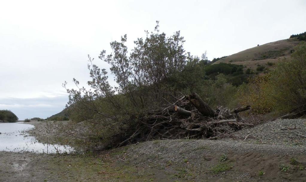
22 Evolution of Cutoff Chutes & Alcoves Chutes Form When Head Loss Cause Upstream Water Surface to Overtop Bar Create by: Lowering Back Bar Height Increasing Head Loss By Adding Wood
23 Effect of Wood Loading τ 0 = ρghs Distance between Wood Pieces Increased Wood Loading increases: - flow depth - energy slope Manga and Kirchner 2000 Activate Off-channel Areas by Adding Wood
")
24 Habitat Value of Medial Bars Medial Bars: Mobile/Low Stability Create Flow Heterogeneity Overtopped by Flows Less than Bankfull Widen Channel Belt by Eroding Banks and Lead to: Vegetated Bars Islands Anabranch (Split) Channels

25 Vegetated Bars & Islands Vegetated Bars Bars Colonized by Vegetation Persistent Overtopped by Flows Less than Bankfull Islands Vegetated Bars which Accumulate Sediment and Grow in Elevation Above Bankfull Length Scales to Pool-Riffle Sequence Long-term Persistence Habitat Benefits Cover Increased Bank Length Velocity Complexity

26 Apex Bar Jam Abbe and Montgomery, 1996

27 Apex Bar Jams

28 Apex Bar Jam in Mattole
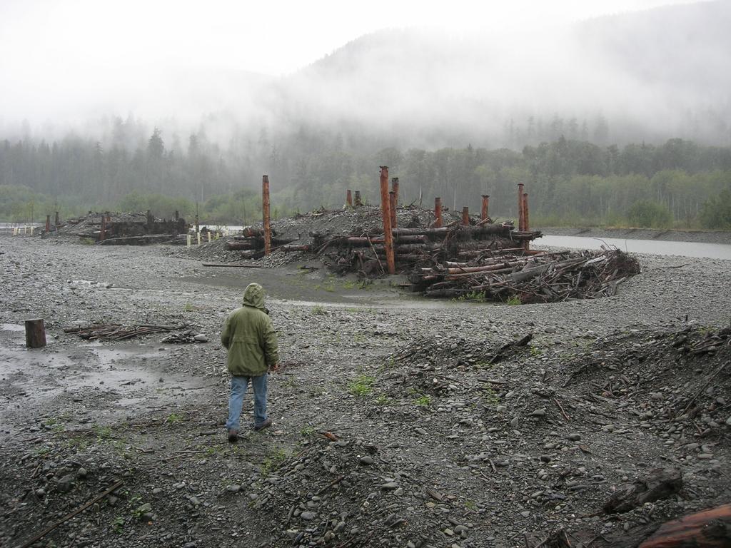
29 Engineered Log Jam
 May Form from Erosion of Floodplain Avulsion into Tributary Channel Nanson and Knighton,")
30 Anabranch Channels Channels with Longer Separation Multiple Pool-Riffle Sequences Island Widths Multiple Channel Widths Unconfined Anabranches (Type 5) May Form from Erosion of Floodplain Avulsion into Tributary Channel Nanson and Knighton, 1996

31 Constructing an Anabranch: Design Issues Location Entrance Configuration Exit Configuration Middle Dependent on Boundary Conditions
32 Anabranch Channel Location Specific Requirements -- Not Random Stable Anabranch Channels 5% - 20% of Total Flow Separated at Flows > Bankfull Discharge Typically Have Slope Advantage Ss > Sm Entrance at Riffle Head Generally on Inside of Bends Hard Point at Bifurcation Employ Abandoned Channels and Tributary Channels
 Limited Bifurcation Angle Branch Asymmetry (Ws << Wm) Flow Separation Above Bankfull Burge")
33 Stable Entrance Characteristics Expanding Approach Channel Width Transverse Bed Head Drop In Main Branch Inlet Step In Side Branch Slope Advantage (Ss > Sm) Limited Bifurcation Angle Branch Asymmetry (Ws << Wm) Flow Separation Above Bankfull Burge 2006
34 Confluence Characteristics Downstream Bar On Minor Channel Side Avalanche Faces At Confluence Enhanced Scour in Channel Below Confluence
35 Design Elements for Off-Channel Habitat in Lowlands Objectives: Wet Season Rearing Summer Cool Water Refugia Floodplain Access Movement Cover Complexity Design Elements Cutoff Chutes Backwater Channels Seasonal Wetlands Anastomosed Streams Avulsions Wood Jams
36 Backwater Channel Formed Where Downstream Grade Control Elevates Water Surface Flow Appropriate for Lowland Stream Because: L b = h/s f

37 Backwater Channel Design: Salt Creek Grade Control
38 Backwater Sediment Issues If Sediment Load is present: - Channel Entrances May Become Blocked - Off-Channel Pools May Fill with Fine Sediment - Raising Backwater Height May Result in Channel Aggradation
39 Avulsion: Anastomosed Streams and Avulsions Rapid shift of channel belt into new location. Associated with channel aggradation and sinuous streams. New channels typically steeper than original. Anastomosed Streams: Channel form with parallel channels separate by wide, cohesive, vegetated floodplains.

40 Anastomosing Channel Benefits Multiple Channels Complex Habitat Taiya River, AK Use in Restoration Requires: Wide Floodplain Low Potential for Land-use Conflicts Abbe, Brooks, and Montgomery, 2003
41 Avulsions: Hazards & Opportunities

42 Opportunities: Access to Off-Channel Habitat Cross-basin Connectivity Hazards Channel Capture Flooding Stranding

43 Other Lowland Design Issues: Lack of Cover and Water Temperature Groundwater Connection Anoxic Soils Riparian Disturbance
44 Design Elements for Off-Channel Habitat in Estuaries Objectives: Wet Season Rearing Freshwater Refugia Permanently Flooded High Flow Refugia Movement Cover Complexity Design Elements Seasonal Freshwater Wetlands Wood Jams Channel Connectivity Cross Connections Restore Side-channels Tide Gate Improvements


45 Summary Clearly Identify Habitat Goals & Objectives Address Landscape & Watershed Controls Select Appropriate Design Elements Allow Processes to Work
Step 5: Channel Bed and Planform Changes
 Step 5: Channel Bed and Planform Changes When disturbed, streams go through a series of adjustments to regain equilibrium with the flow and sediment supply of their watersheds. These adjustments often
Aquifer an underground zone or layer of sand, gravel, or porous rock that is saturated with water.
 Aggradation raising of the streambed by deposition that occurs when the energy of the water flowing through a stream reach is insufficient to transport sediment conveyed from upstream. Alluvium a general
Riparian Assessment. Steps in the right direction... Drainage Basin/Watershed: Start by Thinking Big. Riparian Assessment vs.
 Riparian Assessment vs. Monitoring Riparian Assessment What is a healthy stream? Determine stream/riparian health Determine change or trend, especially in response to mgmt Classification = designation
Stream Geomorphology. Leslie A. Morrissey UVM July 25, 2012
 Stream Geomorphology Leslie A. Morrissey UVM July 25, 2012 What Functions do Healthy Streams Provide? Flood mitigation Water supply Water quality Sediment storage and transport Habitat Recreation Transportation
!"#$%&&'()*+#$%(,-./0*)%(!
*+#$%(,-./0*)%(!") 8:30 Sign in Hoosic River Revival Coalition!"#$%&&'()*+#$%(,-./0*)%(! 12-#30+4/#"5-(60 9:00 Welcome and Introductions 9:15 Goals for Today s Program: A Description of the Planning Process 9:30 First Session:
8:30 Sign in Hoosic River Revival Coalition!"#$%&&'()*+#$%(,-./0*)%(! 12-#30+4/#"5-(60 9:00 Welcome and Introductions 9:15 Goals for Today s Program: A Description of the Planning Process 9:30 First Session:
Why Geomorphology for Fish Passage
 Channel Morphology - Stream Crossing Interactions An Overview Michael Love Michael Love & Associates mlove@h2odesigns.com (707) 476-8938 Why Geomorphology for Fish Passage 1. Understand the Scale of the
Stream Classification
 Stream Classification Why Classify Streams? Communication Tool Describe Existing Conditions & Trends Describe Restoration Goals Research Tool Morphologic Stream Classification Systems Schumm (1977) Alluvial
SCOPE OF PRESENTATION STREAM DYNAMICS, CHANNEL RESTORATION PLANS, & SEDIMENT TRANSPORT ANALYSES IN RELATION TO RESTORATION PLANS
 DESIGN METHODS B: SEDIMENT TRANSPORT PROCESSES FOR STREAM RESTORATION DESIGN PETER KLINGEMAN OREGON STATE UNIVERSITY CIVIL ENGINEERING DEPT., CORVALLIS 2 ND ANNUAL NORTHWEST STREAM RESTORATION DESIGN SYMPOSIUM
NATURAL RIVER. Karima Attia Nile Research Institute
 NATURAL RIVER CHARACTERISTICS Karima Attia Nile Research Institute NATURAL RIVER DEFINITION NATURAL RIVER DEFINITION Is natural stream of water that flows in channels with ih more or less defined banks.
Business. Meteorologic monitoring. Field trip? Reader. Other?
 Business Meteorologic monitoring Field trip? Reader Other? Classification Streams Characterization Discharge measurements Why classify stream channels? Why Classify Stream Channels? Provides a common language
Conceptual Model of Stream Flow Processes for the Russian River Watershed. Chris Farrar
 Conceptual Model of Stream Flow Processes for the Russian River Watershed Chris Farrar Several features of creeks affect the interactions between surface and groundwater. This conceptual model uses the
Do you think sediment transport is a concern?
 STREAM RESTORATION FRAMEWORK AND SEDIMENT TRANSPORT BASICS Pete Klingeman 1 What is Your Restoration Project Like? k? Do you think sediment transport is a concern? East Fork Lewis River, WA Tidal creek,
Appendix III-A Descriptions of Channel Habitat Types
 Appendix III-A Descriptions of Channel Habitat Types Table of Contents Channel Habitat Typing Background... 3 Small Estuarine Channel (ES)... 7 Large Estuarine Channel (EL)... 9 Low Gradient Large Floodplain
ODFW AQUATIC INVENTORY PROJECT OREGON PLAN FOR SALMON & WATERSHEDS STREAM RESTORATION HABITAT REPORT
 ODFW AQUATIC INVENTORY PROJECT OREGON PLAN FOR SALMON & WATERSHEDS STREAM RESTORATION HABITAT REPORT STREAM: BASIN: SURVEY TYPE: Munson Creek (NC-342) Tillamook River Post-Tx DATE: February 2, 28 SURVEY
Rivers T. Perron
 1 Rivers T. Perron 12.001 After our discussions of large-scale topography, how we represent topography in maps, and how topography interacts with geologic structures, you should be frothing at the mouth
Technical Memorandum. To: From: Copies: Date: 10/19/2017. Subject: Project No.: Greg Laird, Courtney Moore. Kevin Pilgrim and Travis Stroth
 Technical Memorandum To: From: Greg Laird, Courtney Moore Kevin Pilgrim and Travis Stroth 5777 Central Avenue Suite 228 Boulder, CO 80301 www.otak.com Copies: [Electronic submittal] Date: 10/19/2017 Subject:
Forest Service AOP Meeting Objectives of Stream Simulation: Examples and Talking Points
 Forest Service AOP Meeting Objectives of Stream Simulation: Examples and Talking Points Traci Sylte, P.E. Hydrology/Fluvial Geomorphology Lolo National Forest Is It True? Are Road Crossings a Dam with
PolyMet NorthMet Project
 RS 26 Draft-01 December 8, 2005 RS26 Partridge River Level 1 Rosgen Geomorphic Survey Rosgen Classification Partridge River from Headwaters to Colby Lake Prepared for PolyMet NorthMet Project December
NATURE OF RIVERS B-1. Channel Function... ALLUVIAL FEATURES. ... to successfully carry sediment and water from the watershed. ...dissipate energy.
 1 2 Function... Sevier River... to successfully carry sediment and water from the watershed....dissipate energy. 3 ALLUVIAL FEATURES 4 CHANNEL DIMENSION The purpose of a stream is to carry water and sediment
Assessment. Assessment
 2001 SPRINGBROOK CREEK RESTORATION - THREE YEAR POST-CONSTRUCTION REVIEW - Presented by Bruce Henderson and Andy Harris 2005 River Restoration Northwest Symposium Skamania Lodge, Washington www.hendersonlandservices.com
GLG362/GLG598 Geomorphology K. Whipple October, 2009 I. Characteristics of Alluvial Channels
 I. Characteristics of Alluvial Channels Self-formed morphology set by entrainment, transport, and deposition They move unconsolidated sedimentary materials present in the valley fill flood plain/bank flow
OBJECTIVES. Fluvial Geomorphology? STREAM CLASSIFICATION & RIVER ASSESSMENT
 STREAM CLASSIFICATION & RIVER ASSESSMENT Greg Babbit Graduate Research Assistant Dept. Forestry, Wildlife & Fisheries Seneca Creek, Monongahela National Forest, West Virginia OBJECTIVES Introduce basic
Channel Pattern. Channel Pattern, Meanders, and Confluences. Description of Channel Pattern. Bridge (2003)
") Channel Pattern Channel Pattern, Meanders, and Confluences Outline Description of channel pattern Alternate bars Channel pattern continua and evolution Controls of channel pattern Description of Channel
Channel Pattern Channel Pattern, Meanders, and Confluences Outline Description of channel pattern Alternate bars Channel pattern continua and evolution Controls of channel pattern Description of Channel
APPENDIX E. GEOMORPHOLOGICAL MONTORING REPORT Prepared by Steve Vrooman, Keystone Restoration Ecology September 2013
 APPENDIX E GEOMORPHOLOGICAL MONTORING REPORT Prepared by Steve Vrooman, Keystone Restoration Ecology September 2 Introduction Keystone Restoration Ecology (KRE) conducted geomorphological monitoring in
Dan Miller + Kelly Burnett, Kelly Christiansen, Sharon Clarke, Lee Benda. GOAL Predict Channel Characteristics in Space and Time
 Broad-Scale Models Dan Miller + Kelly Burnett, Kelly Christiansen, Sharon Clarke, Lee Benda GOAL Predict Channel Characteristics in Space and Time Assess Potential for Fish Use and Productivity Assess
Wetland & Floodplain Functional Assessments and Mapping To Protect and Restore Riverine Systems in Vermont. Mike Kline and Laura Lapierre Vermont DEC
 Wetland & Floodplain Functional Assessments and Mapping To Protect and Restore Riverine Systems in Vermont Mike Kline and Laura Lapierre Vermont DEC NWI+ Hydro-Geomorphic Characterization of Wetlands and
Tom Ballestero University of New Hampshire. 1 May 2013
 Tom Ballestero University of New Hampshire 1 May 2013 1 Hydrology 2 Basic Hydrology Low flows most common Flows that fill the stream to the banks and higher are much less common Filling the stream to the
Human Impacts to Rivers
 Human Impacts to Rivers Sediment Water Wood Confinement Valley slope Channel morphology Bank material Flow obstructions Riparian vegetation Human Impacts on Rivers dams channelization loss of woody debris/riparian
May 7, Roger Leventhal, P.E. Marin County Public Works Laurel Collins Watershed Sciences
 May 7, 2013 Roger Leventhal, P.E. Marin County Public Works Laurel Collins Watershed Sciences Background Funded in 2009 under EPA 2100 Grant for $30k and managed by SFEP Project Goals: Update original
CR AAO Bridge. Dead River Flood & Natural Channel Design. Mitch Koetje Water Resources Division UP District
 CR AAO Bridge Dead River Flood & Natural Channel Design Mitch Koetje Water Resources Division UP District Old County Road AAO Bridge Map courtesy of Marquette County Silver Lake Basin McClure Basin
Start of Presentation: No notes (Introductory Slide 1) 1) Salmonid Habitat Intrinsic Potential (IP) models are a type of habitat potential
 1) Salmonid Habitat Intrinsic Potential (IP) models are a type of habitat potential") The What and How of Salmonid Habitat Intrinsic Potential Modeling Start of Presentation: No notes (Introductory Slide 1) 1) Salmonid Habitat Intrinsic Potential (IP) models are a type of habitat potential
The What and How of Salmonid Habitat Intrinsic Potential Modeling Start of Presentation: No notes (Introductory Slide 1) 1) Salmonid Habitat Intrinsic Potential (IP) models are a type of habitat potential
Why Stabilizing the Stream As-Is is Not Enough
 Why Stabilizing the Stream As-Is is Not Enough Several examples of alternatives to the County s design approach have been suggested. A common theme of these proposals is a less comprehensive effort focusing
Solutions to Flooding on Pescadero Creek Road
 Hydrology Hydraulics Geomorphology Design Field Services Photo courtesy Half Moon Bay Review Solutions to Flooding on Pescadero Creek Road Prepared for: San Mateo County Resource Conservation District
Annotated Bibliography of River Avulsions Pat Dryer Geography 364 5/14/2007
 Annotated Bibliography of River Avulsions Pat Dryer Geography 364 5/14/2007 1 Table of Contents Introduction 2 Annotations I. River avulsions and their deposits 2 II. Channel avulsion on alluvial fans
DETAILED DESCRIPTION OF STREAM CONDITIONS AND HABITAT TYPES IN REACH 4, REACH 5 AND REACH 6.
 DETAILED DESCRIPTION OF STREAM CONDITIONS AND HABITAT TYPES IN REACH 4, REACH 5 AND REACH 6. The Eklutna River was divided into study reaches (figure 1) prior to this site visit. Prominent geologic or
Vermont Stream Geomorphic Assessment. Appendix E. River Corridor Delineation Process. VT Agency of Natural Resources. April, E0 - April, 2004
 Vermont Stream Geomorphic Assessment Appendix E River Corridor Delineation Process Vermont Agency of Natural Resources - E0 - River Corridor Delineation Process Purpose A stream and river corridor delineation
State of the River: Geomorphic Structure. Josh Wyrick, Ph.D. UC Davis
 State of the River: Geomorphic Structure Josh Wyrick, Ph.D. UC Davis 1 Geomorphic Structure Methodology Data Collection (topography, rating curve, hydraulics, substrate, vegetation & cover) GIS-Based Analyses
GEOL 1121 Earth Processes and Environments
 GEOL 1121 Earth Processes and Environments Wondwosen Seyoum Department of Geology University of Georgia e-mail: seyoum@uga.edu G/G Bldg., Rm. No. 122 Seyoum, 2015 Chapter 6 Streams and Flooding Seyoum,
ODFW AQUATIC INVENTORY PROJECT OREGON PLAN FOR SALMON & WATERSHEDS STREAM RESTORATION HABITAT REPORT
 ODFW AQUATIC INVENTORY PROJECT OREGON PLAN FOR SALMON & WATERSHEDS STREAM RESTORATION HABITAT REPORT STREAM: BASIN: SURVEY TYPE: South Sister Creek (U-5) Smith River Pre-Tx DATE: January 7, 4 SURVEY CREW:
Opportunities to Improve Ecological Functions of Floodplains and Reduce Flood Risk along Major Rivers in the Puget Sound Basin
 Opportunities to Improve Ecological Functions of Floodplains and Reduce Flood Risk along Major Rivers in the Puget Sound Basin Christopher Konrad, US Geological Survey Tim Beechie, NOAA Fisheries Managing
River Response. Sediment Water Wood. Confinement. Bank material. Channel morphology. Valley slope. Riparian vegetation.
 River Response River Response Sediment Water Wood Confinement Valley slope Channel morphology Bank material Flow obstructions Riparian vegetation climate catchment vegetation hydrological regime channel
The Effects of Geomorphology and Watershed Land Use on Spawning Habitat
 The Effects of Geomorphology and Watershed Land Use on Spawning Habitat By Evan Buckland INTRODUCTION The distribution and frequency of large geomorphic features in a watershed govern where suitable spawning
3/3/2013. The hydro cycle water returns from the sea. All "toilet to tap." Introduction to Environmental Geology, 5e
 Introduction to Environmental Geology, 5e Running Water: summary in haiku form Edward A. Keller Chapter 9 Rivers and Flooding Lecture Presentation prepared by X. Mara Chen, Salisbury University The hydro
Addressing the Impact of Road-Stream Crossing Structures on the Movement of Aquatic Organisms
 Scott Jackson University of Massachusetts Amherst Addressing the Impact of Road-Stream Crossing Structures on the Movement of Aquatic Organisms Dams Sub-standard Culverts Excessive Velocities Inlet Drop
Running Water Earth - Chapter 16 Stan Hatfield Southwestern Illinois College
 Running Water Earth - Chapter 16 Stan Hatfield Southwestern Illinois College Hydrologic Cycle The hydrologic cycle is a summary of the circulation of Earth s water supply. Processes involved in the hydrologic
The River Restoration Centre therrc.co.uk. Understanding Fluvial Processes: supporting River Restoration. Dr Jenny Mant
 The River Restoration Centre therrc.co.uk Understanding Fluvial Processes: supporting River Restoration Dr Jenny Mant Jenny@therrc.co.uk Understanding your catchment Hydrology Energy associated with the
PHYSICAL GEOGRAPHY. By Brett Lucas
 PHYSICAL GEOGRAPHY By Brett Lucas FLUVIAL PROCESSES Fluvial Processes The Impact of Fluvial Processes on the Landscape Streams and Stream Systems Stream Channels Structural Relationships The Shaping and
A GEOMORPHOLOGICAL APPROACH TO RESTORATION OF INCISED RIVERS. David L. Rosgen 1
 Proceedings of the Conference on Management of Landscapes Disturbed by Channel Incision, 1997 S.S.Y. Wang, E.J. Langendoen and F.D. Shields, Jr. (eds.) ISBN 0-937099-05-8 A GEOMORPHOLOGICAL APPROACH TO
Dolores River Watershed Study
 CHAPTER 4: RIVER AND FLOODPLAIN ISSUES The Dolores River falls into a category of streams in Colorado that share some unique characteristics. Like some other mountain streams in the state, it has a steep
Lower South Fork McKenzie River Floodplain Enhancement Project
 Lower South Fork McKenzie River Floodplain Enhancement Project McKenzie River Ranger District Willamette National Forest Project Location The project is located in the South Fork McKenzie River Watershed,
Streams. Stream Water Flow
 CHAPTER 14 OUTLINE Streams: Transport to the Oceans Does not contain complete lecture notes. To be used to help organize lecture notes and home/test studies. Streams Streams are the major geological agents
Upper Truckee River Restoration Lake Tahoe, California Presented by Brendan Belby Sacramento, California
 Upper Truckee River Restoration Lake Tahoe, California Presented by Brendan Belby Sacramento, California Mike Rudd (Project Manager), Charley Miller & Chad Krofta Declines in Tahoe s Water Clarity The
Ms. A. Mormando's Class *
 8 th Grade Science Essential Standard: 8.E.1.1 Explain the structure of the hydrosphere including: Water distribution on Earth; Local river basin and water availability Stream - A stream is a body of water
Natural Shoreline Landscapes on Michigan Inland Lakes
 Natural Shoreline Landscapes on Michigan Inland Lakes Excerpts from Chapters 2 and 3 Photo Photo by Jane by Jane Herbert Herbert Did you know? Twenty-four species of amphibians, 25 species of reptiles,
(3) Sediment Movement Classes of sediment transported
 Sediment Movement Classes of sediment transported") 9/17/15 (3) Sediment Movement Classes of sediment transported Dissolved load Suspended load Important for scouring algae Bedload (5-10% total load) Moves along bed during floods Source of crushing for
9/17/15 (3) Sediment Movement Classes of sediment transported Dissolved load Suspended load Important for scouring algae Bedload (5-10% total load) Moves along bed during floods Source of crushing for
Rosgen Classification Unnamed Creek South of Dunka Road
 Rosgen Classification Unnamed Creek South of Dunka Road Prepared for Poly Met Mining Inc. September 2013 Rosgen Classification Unnamed Creek South of Dunka Road Prepared for Poly Met Mining Inc. September
New Approaches to Restoring NH s Rivers Natural Channel Design and Dam Removal
 NHACC Annual Meeting 2012 New Approaches to Restoring NH s Rivers Natural Channel Design and Dam Removal Peter J. Walker CROOKED STREAMS are a menace to life and crops in the areas bordering on their banks.
Important Copyright Information
 Important Copyright Information The following content is provided for educational purposes by the workshop presenter. This content may or may not have been peer reviewed. Information, opinions and recommendations
Consequences of river regulation works: altered fluvial processes + increasing flood hazard
 Consequences of river regulation works: altered fluvial processes + increasing flood hazard Dr. Tímea Kiss assistant professor Department of Physical Geography and Geoinformatics, University of Szeged,
Fluvial Geomorphology
 Geomorphic Components of Riparian Ecosystems W. Barry Southerland, Ph.D. Fluvial Geomorphologist, CPESC #514 West National Technology Support Center Water Quality and Quantity Technology Development Team
Attachment D. Technical Memorandum, Susitna River Large Woody Debris Reconnaissance (March 2013)
") Attachment D Technical Memorandum, Susitna River Large Woody Debris Reconnaissance (March 2013) Technical Memorandum Susitna River Large Woody Debris Reconnaissance Susitna- Watana Hydroelectric Project
Attachment D Technical Memorandum, Susitna River Large Woody Debris Reconnaissance (March 2013) Technical Memorandum Susitna River Large Woody Debris Reconnaissance Susitna- Watana Hydroelectric Project
Thank you to all of our 2015 sponsors: Media Partner
 Thank you to all of our 2015 sponsors: Media Partner Fluvial System Concepts and Their Application in Greenfield Stream Corridor Realignment Dr. Paul Villard, P.Geo. GEO Morphix Ltd. Overview Major realignment
1 INTRODUCTION AND MAJOR FINDINGS... 1
 Memorandum To: Lindsey Clark, Stillwater Valley Watershed Council Coordinator From: Chad Raisland, Pioneer Technical Services, Inc. and Karin Boyd, Applied Geomorphology, Inc. CC: Tanya Lester, Stillwater
Ways To Identify Background Verses Accelerated Erosion
 Ways To Identify Background Verses Accelerated Erosion Establish Background Condition From Old Ground Photos, Aerial Photos, and Maps Compare Rate Over Time At the Same Location, or for Reaches Channel
Overview of fluvial and geotechnical processes for TMDL assessment
 Overview of fluvial and geotechnical processes for TMDL assessment Christian F Lenhart, Assistant Prof, MSU Research Assoc., U of M Biosystems Engineering Fluvial processes in a glaciated landscape Martin
Restoring the Napa River:
 Restoring the Napa River: lessons learned from a long term private-public project Andy Collison Environmental Science Associates acollison@esassoc.com 1 Napa River Restoration Projects Rutherford Reach
Surface Water and Stream Development
 Surface Water and Stream Development Surface Water The moment a raindrop falls to earth it begins its return to the sea. Once water reaches Earth s surface it may evaporate back into the atmosphere, soak
GENERAL SUMMARY BIG WOOD RIVER GEOMORPHIC ASSESSMENT BLAINE COUNTY, IDAHO
 GENERAL SUMMARY BIG WOOD RIVER GEOMORPHIC ASSESSMENT BLAINE COUNTY, IDAHO Prepared For Trout Unlimited 300 North Main Street, Hailey, Idaho, 83333 Prepared By P. O. Box 8578, 140 E. Broadway, Suite 23,
Stream Restoration and Environmental River Mechanics. Objectives. Pierre Y. Julien. 1. Peligre Dam in Haiti (deforestation)
") Stream Restoration and Environmental River Mechanics Pierre Y. Julien Malaysia 2004 Objectives Brief overview of environmental river mechanics and stream restoration: 1. Typical problems in environmental
Stream Restoration and Environmental River Mechanics Pierre Y. Julien Malaysia 2004 Objectives Brief overview of environmental river mechanics and stream restoration: 1. Typical problems in environmental
Elwha River response to dam removals through four years and a big flood:
 Elwha River response to dam removals through four years and a big flood: Lessons learned, channel response, and sediment effects from the world s largest engineered dam removal Andy Ritchie NPS Elwha Restoration
Columbia Estuary Province
 Rolling Provincial Review: Implementation 2001-2004 Province 73 Columbia Basin Fish & Wildlife Authority Province FY 2001-2004 Spending Summaries NPCC Recommendations and BPA Spending by Project Category,
Birch Creek Geomorphic Assessment and Action Plan
 Birch Creek Geomorphic Assessment and Action Plan Jim Webster Tim Hanrahan, PhD, CFM Jesse Schwartz, PhD Zach Hill January 22, 2015 White Eagle Grange This Project is a First Step in Strategy Planning
Fish Passage at Road Crossings
 Fish Passage at Road Crossings 1 Crossing Design Workshop Outline 1:00 to 2:00 Intro, Design Overview, Channel Width 2:00 to 2:15 Break 2:15 to 3:15 No-Slope, Stream Simulation Design 3:15 to 3:30 Break
How Do Human Impacts and Geomorphological Responses Vary with Spatial Scale in the Streams and Rivers of the Illinois Basin?
 How Do Human Impacts and Geomorphological Responses Vary with Spatial Scale in the Streams and Rivers of the Illinois Basin? Bruce Rhoads Department of Geography University of Illinois at Urbana-Champaign
Running Water: The Geology of Streams and Floods Running Water Chapter 14
 Geology 800 Today Running Water: The Geology of Streams and Floods Running Water Chapter 14 Next Class Oceans and Coasts 15 Stream Flow Streams Ribbons of water that flow down channels. Runoff Water in
Perspectives on river restoration science, geomorphic processes, and channel stability
 Perspectives on river restoration science, geomorphic processes, and channel stability Stream Restoration Forum: Science and Regulatory Connections Andrew C. Wilcox Department of Geosciences University
Stream Simulation: A Simple Example
 Stream Simulation: A Simple Example North Thompson Creek, CO Paul T. Anderson U.S.D.A. Forest Service Here s How We Started May 2011 2-1 USDA-Forest Service Here s How We Finished Forest Service Aquatic
(3) Sediment Movement Classes of sediment transported
 Sediment Movement Classes of sediment transported") (3) Sediment Movement Classes of sediment transported Dissolved load Suspended (and wash load ) Important for scouring algae Bedload (5-10% total load Moves along bed during floods Source of crushing for
(3) Sediment Movement Classes of sediment transported Dissolved load Suspended (and wash load ) Important for scouring algae Bedload (5-10% total load Moves along bed during floods Source of crushing for
Restoration Goals TFG Meeting. Agenda
 San Joaquin River Restoration Program Restoration Goals TFG Meeting Reach 2B Update April 28, 2010 Agenda 1. Introductions 2. Program Restoration Goal Context 3. Program Update a) Interim Flows b) EIS/EIR
Diagnostic Geomorphic Methods for Understanding Future Behavior of Lake Superior Streams What Have We Learned in Two Decades?
 Diagnostic Geomorphic Methods for Understanding Future Behavior of Lake Superior Streams What Have We Learned in Two Decades? Faith Fitzpatrick USGS WI Water Science Center, Middleton, WI fafitzpa@usgs.gov
Rapid Geomorphic Assessments: RGA s
 Establishing Current Reference Conditions Rates and concentrations of suspended-sediment transport vary over time and space due to factors such as precipitation characteristics and discharge, geology,
Year 6. Geography. Revision
 Year 6 Geography Revision November 2017 Rivers and World knowledge How the water cycle works and the meaning of the terms evaporation, condensation, precipitation, transpiration, surface run-off, groundwater
WATER ON AND UNDER GROUND. Objectives. The Hydrologic Cycle
 WATER ON AND UNDER GROUND Objectives Define and describe the hydrologic cycle. Identify the basic characteristics of streams. Define drainage basin. Describe how floods occur and what factors may make
The last three sections of the main body of this report consist of:
 Threatened and Endangered Species Geological Hazards Floodplains Cultural Resources Hazardous Materials A Cost Analysis section that provides comparative conceptual-level costs follows the Environmental
River Morphology. EAD 511 River management
 River Morphology EAD 511 River management Introduction FLUVIAL GEOMORPHOLOGY Webster's New World Dictionary defines fluvial as: of, found in, or produced by a river or rivers. The same reference defines
River Nith restoration, cbec UK Ltd, October 2013 APPENDIX A
 APPENDIX A FLUVIAL AUDIT METHOD STATEMENT Fluvial Audit Methodology INTRODUCTION The procedure used to characterize the geomorphic and sedimentary regimes of the River Till is an adaptation of the Fluvial
Upper Mississippi River Basin Environmental Management Program Workshop
 Presentation to the Upper Mississippi River Basin Environmental Management Program Workshop by Michael Rodgers River Engineer US Army Corps of Engineers, St. Louis District August 17, 2007 Engineering
Surface Processes Focus on Mass Wasting (Chapter 10)
") Surface Processes Focus on Mass Wasting (Chapter 10) 1. What is the distinction between weathering, mass wasting, and erosion? 2. What is the controlling force in mass wasting? What force provides resistance?
Surface Processes Focus on Mass Wasting (Chapter 10) 1. What is the distinction between weathering, mass wasting, and erosion? 2. What is the controlling force in mass wasting? What force provides resistance?
Working with Natural Stream Systems
 Working with Natural Stream Systems Graydon Dutcher Delaware County Soil & Water Conservation District Stream Corridor Management Program Tropical Storm Sandy October 29,2012 What is a Watershed?
Belt Width Delineation Procedures
 Belt Width Delineation Procedures Report to: Attention: Report No: 5 Shoreham Drive, Downsview, Ontario M3N 1S4 Mr. Ryan Ness 98-023 Date: Sept 27, 2001 (Revised January 30, 2004) Submitted by: Table of
Fresh Water: Streams, Lakes Groundwater & Wetlands
 Fresh Water:, Lakes Groundwater & Wetlands Oct 27 Glaciers and Ice Ages Chp 13 Nov 3 Deserts and Wind and EXAM #3 Slope hydrologic cycle P = precip I = precip intercepted by veg ET = evapotranspiration
Integrating flood mitigation, sediment management and habitat enhancement on coastal rivers of British Columbia
 River Basin Management VII 301 Integrating flood mitigation, sediment management and habitat enhancement on coastal rivers of British Columbia D. McLean 1, V. Galay 1, B. Wright 2 & W. Fleenor 3 1 Northwest
Laboratory Exercise #3 The Hydrologic Cycle and Running Water Processes
 Laboratory Exercise #3 The Hydrologic Cycle and Running Water Processes page - 1 Section A - The Hydrologic Cycle Figure 1 illustrates the hydrologic cycle which quantifies how water is cycled throughout
Field Methods to Determine/ Verify Bankfull Elevation, XS Area & Discharge
 Module # 6 Field Methods to Determine/ Verify Bankfull Elevation, XS Area & Discharge Iowa s River Restoration Toolbox Level 1 / Base Training Overview of Basic Field Data Collection Site Map Cross Sections
Fluvial Geomorphic Guidelines
 Fluvial Geomorphic Guidelines FACT SHEET I: GEOMORPHOLOGICAL HAZARDS CONFINED AND UNCONFINED WATERCOURSES Channel migration and erosion can create substantial risk to inappropriately located infrastructure
Gully Erosion Part 1 GULLY EROSION AND ITS CAUSES. Introduction. The mechanics of gully erosion
 Gully Erosion Part 1 GULLY EROSION AND ITS CAUSES Gully erosion A complex of processes whereby the removal of soil is characterised by incised channels in the landscape. NSW Soil Conservation Service,
27. Running Water I (p ; )
") 27. Running Water I (p. 424-436; 440-444) Hydrosphere How much of the Earth s surface is covered by water? Earth's water is collectively called the and is stored in a number of so-called as follows: 1.
27. Running Water I (p. 424-436; 440-444) Hydrosphere How much of the Earth s surface is covered by water? Earth's water is collectively called the and is stored in a number of so-called as follows: 1.
Factors affecting confluence scour
 & Wang (eds) River Sedimentation 1999., Balkema, Rotterdam. ISBN 9 9 3. 17 19 Factors affecting confluence scour R. B. Rezaur & A. W. Jayawardena. Department of Civil Engineering, The University of Hong
Avoiding Geohazards in the Mid-Atlantic Highlands by Using Natural Stream Principles
 Avoiding Geohazards in the Mid-Atlantic Highlands by Using Natural Stream Principles J. Steven Kite, WVU Neal Carte, WVDOT Will Harman, Michael Baker Corp. Donald D. Gray, WVU Photo: W. Gillespie North
11/12/2014. Running Water. Introduction. Water on Earth. The Hydrologic Cycle. Fluid Flow
 Introduction Mercury, Venus, Earth and Mars share a similar history, but Earth is the only terrestrial planet with abundant water! Mercury is too small and hot Venus has a runaway green house effect so