!"#$%&&'()*+#$%(,-./0*)%(!
|
|
|
- Warren Butler
- 5 years ago
- Views:
Transcription
1 8:30 Sign in Hoosic River Revival Coalition!"#$%&&'()*+#$%(,-./0*)%(! 12-#30+4/#"5-(60 9:00 Welcome and Introductions 9:15 Goals for Today s Program: A Description of the Planning Process 9:30 First Session: Conditions, Issues and Challenges: Hoosic River 101 Presentation (45 minutes) Issues and Opportunities Breakout Groups (55 Minutes) Group Reporting (15 minutes) 12:00 Lunch & Presentation: Examples of River Focused Revitalization in other Communities (30 minutes) 1:00 Second Session: A Vision for the Future Introduction (15 minutes) Vision, Goals, and Objectives for the River Breakout Groups (75 minutes) Future Headline (10 minutes) Group Reporting (15 minutes) 3:00 Summary of the Community Conversation & Wrap up 3:15 Adjourn

2 The Second Step Prepared by: Milone & MacBroom, Inc. June 2010

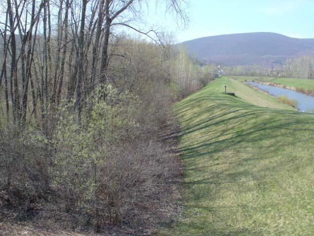
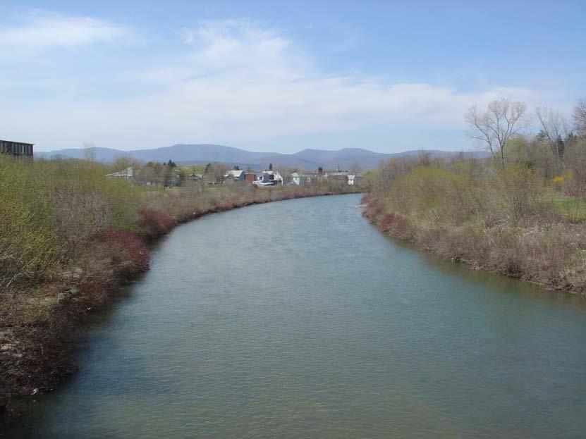
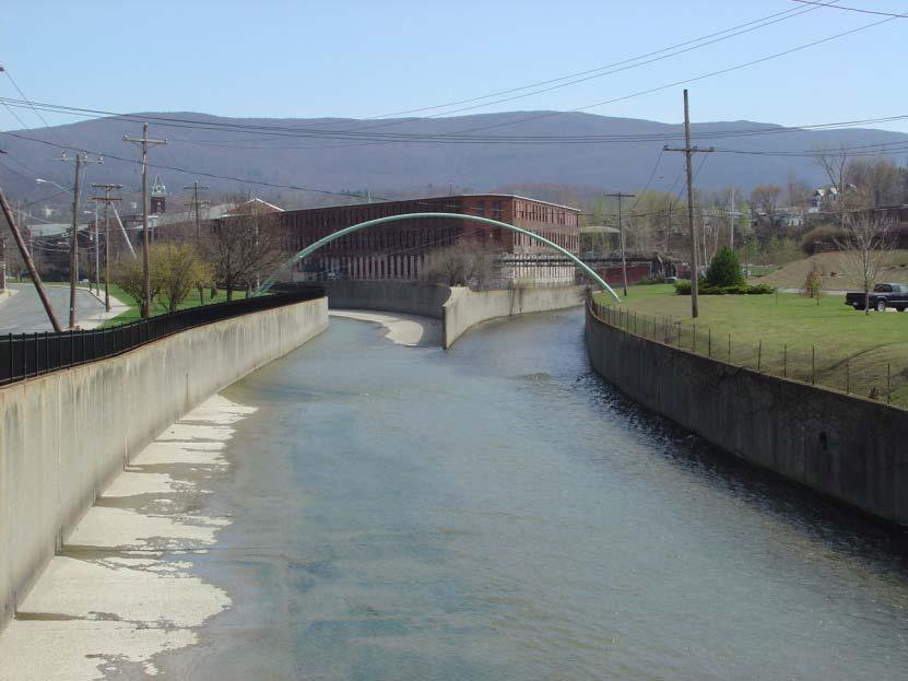
3 Project Site
4 Study Sequence History Hydrology Fluvial Morphology Hydraulics Constraints Opportunities

5 ACTIVE RIPARIAN ZONES Thalweg Channel Channel Banks Riparian Wetlands Floodplains Terrace Scarps Terraces
6 nrcs
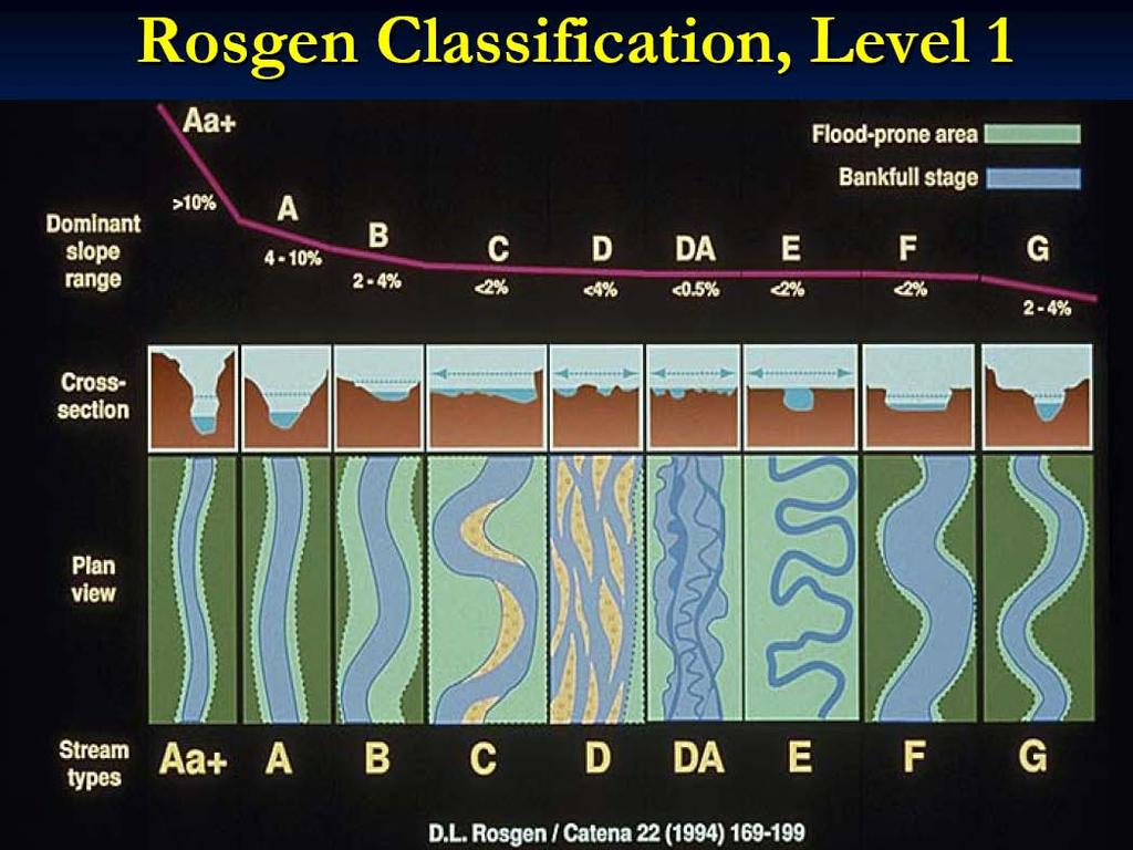
7 1993, 1997 MONTGOMERY & BUFFINGTON CLASSIFICATION
8 River Patterns Slope Discharge Relations X NB X SB X Main Church, 2002

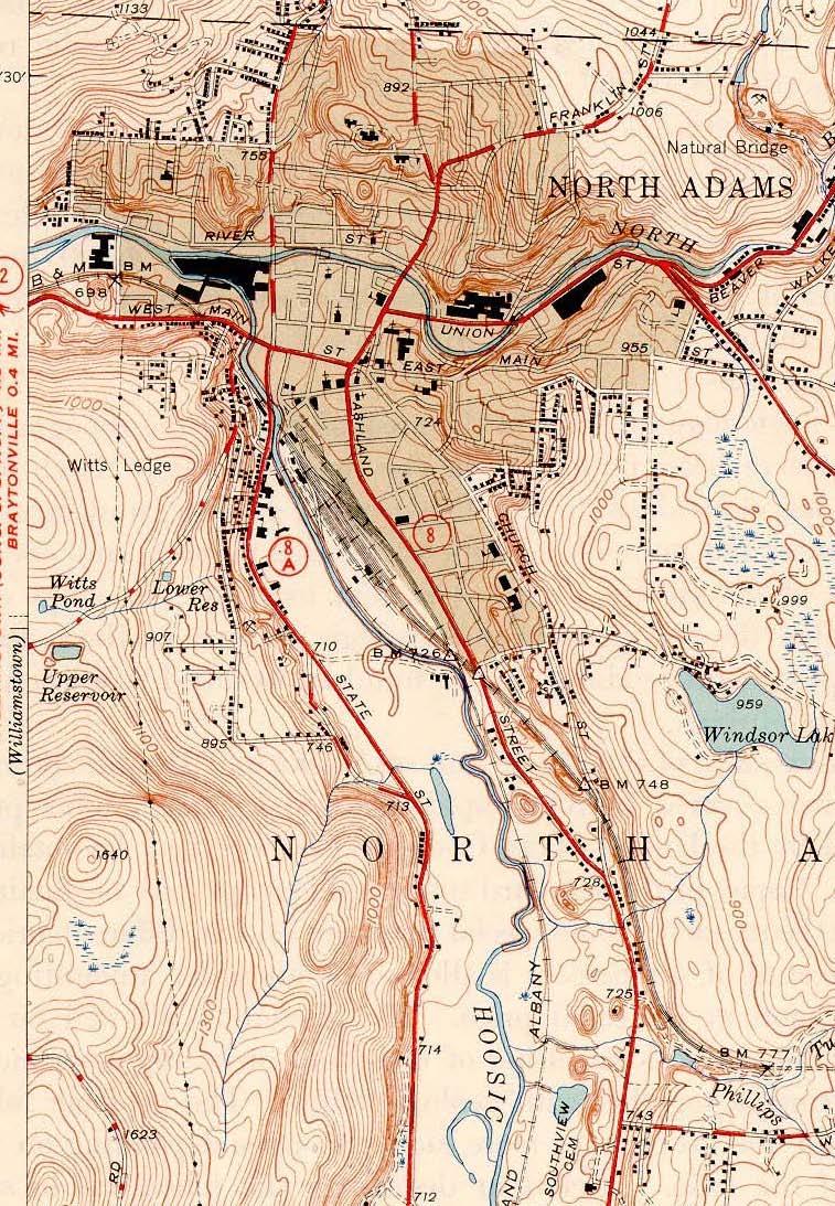
9 1894 USGS MAP 1948 USGS MAP

10 1948: Pre Flood Project
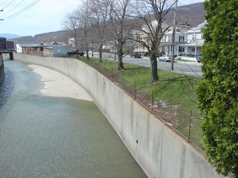
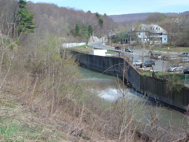
11 PROGRESSIVE URBANIZATION OF A STREAM Floodplain Dam w/ Diversion Progression of Urbanization Wildlife Corridor Fill Direct Discharges Diverse Habitat Source of Organic Material & Shade Retaining Wall Filters Runoff & Sediment Original Stream Channel Filled Wetland & Natural Floodplain Piped Drainage Channelized Stream Realign Channel, Reduce Habitat Size & Value Culverted Tributaries Small Bridge Lined Channel Concrete Liner Culvert Uniform Channel Low Diversity MacBroom, 1998 Culvert
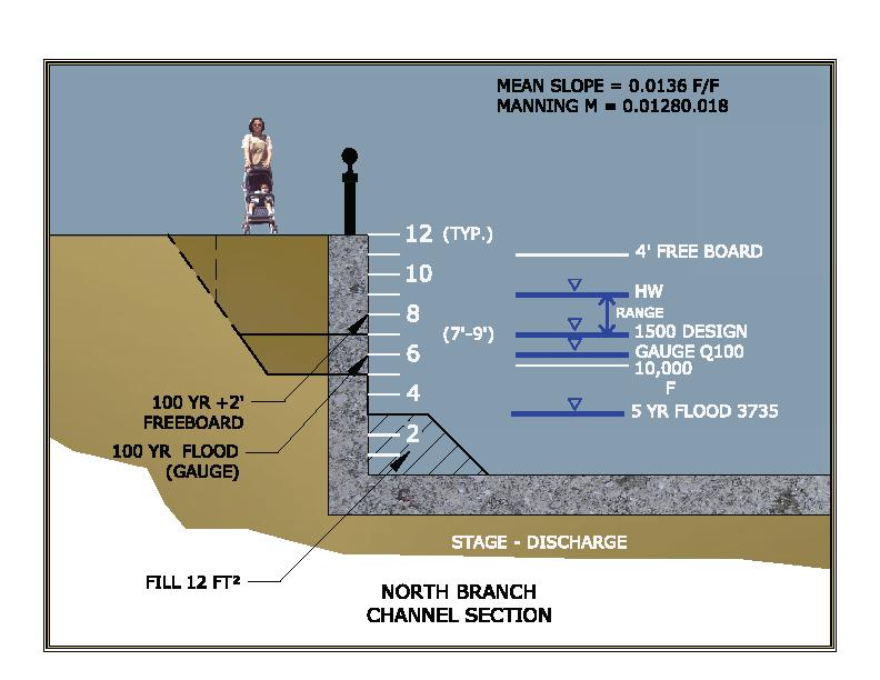
12 ITEM NORTH BRANCH Hydrology SOUTH BRANCH MAIN STEM DATA DATE Watershed, SM Corps Design Flow,CFS FEMA 100 Year Flood, CFS Gauge 100 Year Flood, CFS *150 Percent of the Flood of Record 15,000* 8,200 24,300* ,800 7,228 16, ,184 7,678 13,

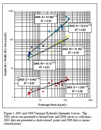
13 NB REFERENCE BANKFULL DATA Width Ft Depth 4 Ft Slope Pattern Straight Sinuosity 1.0 Profile Rapids, Shallow Pool/Riffle


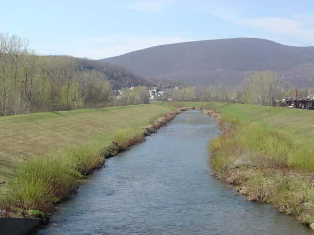
14 North Branch Hoosic River
15
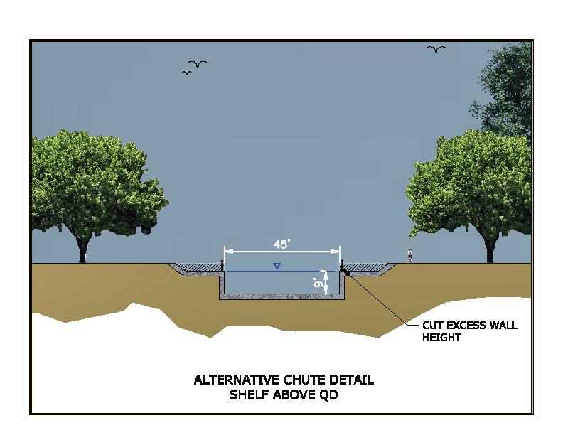
16 Chute Data ITEM NORTH BRANCH SOUTH BRANCH MAIN STEM Width, Feet 45* 45* 85.6 Typical Depth, Feet Mean Slope, Ft/Ft Bridges Drop Structures 2 1 *As Built
17 Bulletin 17B Plot for North Branch Hoosic River Return Period Flow (cfs) Probability Computed Curve Expected Probability Curve 5 Percent Confidence Limit 95 Percent Confidence Limit Observed Events (Weibull plotting positions)
18 North Branch Stage Discharge Actual Reg. Line Stage (ft) Discharge (cfs)[e5]
19
20
21
22
23 NORTH BRANCH HOOSIC RIVER CHANNEL TYPE COMPARISON Channel Type B F Flow Regime <D c >D c Grade Structures Existing Yes Sediment Load Coarse Sand Substrate Cobble Gravel Gradient, %
24 North Branch Hoosic River Alternate 1 Q2=2400 CFS Stability Curve Q = 2400 cfs Total Sediment Concentration = 50 ppm Stability Curve Q = 2400 cfs Total Sediment Concentration = 50 ppm Legend Stability Curve Legend Stability Curve Slope Degradation Slope Degradation Aggradation Aggradation Base Width, ft Depth, ft Bankfull Width & Depth Sand Load, Gravel Bed, 50 PPT
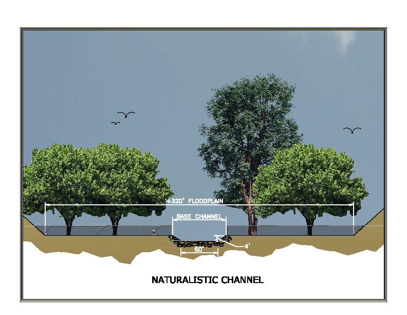
25 Compound Channel Alternate M: 0.03 M :. 0 3 M : M:.06 M:.03 Legend Ground 108 Elevation (ft) Station (ft) Cobble Bed, Sand Load, Low Gradient
26


27 Upper South Branch Hoosic River Reference Reach


28 South Branch Hoosic River
29 South Branch Hoosic River Q2=1115 CFS Stability Curve Q = 1115 cfs Total Sediment Concentration = 30 ppm Stability Curve Q = 1115 cfs Total Sediment Concentration = 30 ppm Legend Stability Curve Legend Stability Curve Slope Degradation Slope Degradation Aggradation Aggradation Base Width, ft Depth, ft Sand Load, Gravel Bed, Bank n=0.04
30 DE CHANNELIZE SOUTH BRANCH Create Backwater Pools Replant Existing Dike Re Naturalize Channel Remove Grade Drop Relocate Dike

31 SOUTH BRANCH BASE FLOWS
32 SOUTH BRANCH FLOODPLAIN RESTORATION Return Flow Re Establish Oxbow Wetland Pool New Channel Upstream Diversion
33 SB Low Flow Diversion Stability Curve Q = 150 cfs Total Sediment Concentration = 50 ppm Stability Curve Q = 150 cfs Total Sediment Concentration = 50 ppm Legend Legend (> Valley Slope) Stability Curve (> Valley Slope) Stability Curve Slope Degradation Slope Degradation Aggradation Aggradation Base Width, ft Depth, ft


34 Main Stem: Hoosic River
35 HOOSIC RIVER SYSTEM, NORTH ADAMS PREDICTED WIDTHS, FT* MAIN STEM SOUTH BRANCH NORTH BRANCH Watershed Area, SM Q2, CFS Reference Reach Width, FT VT HGR Width, FT Sed. Analysis Model, FT (Cobble) 73 (Sand) *Use Compound Channel for Flood Flows
36
37
38
ADDRESSING GEOMORPHIC AND HYDRAULIC CONTROLS IN OFF-CHANNEL HABITAT DESIGN
 ADDRESSING GEOMORPHIC AND HYDRAULIC CONTROLS IN OFF-CHANNEL HABITAT DESIGN Conor Shea - Hydrologist U.S. Fish and Wildlife Service Conservation Partnerships Program Arcata, CA Learning Objectives Examine
PENNSYLVANIA DEPARTMENT OF TRANSPORTATION ENGINEERING DISTRICT 3-0
 PENNSYLVANIA DEPARTMENT OF TRANSPORTATION ENGINEERING DISTRICT 3-0 LYCOMING COUNTY S.R.15, SECTION C41 FINAL HYDROLOGIC AND HYDRAULIC REPORT STEAM VALLEY RUN STREAM RELOCATION DATE: June, 2006 REVISED:
Stream Geomorphology. Leslie A. Morrissey UVM July 25, 2012
 Stream Geomorphology Leslie A. Morrissey UVM July 25, 2012 What Functions do Healthy Streams Provide? Flood mitigation Water supply Water quality Sediment storage and transport Habitat Recreation Transportation
Stream Classification
 Stream Classification Why Classify Streams? Communication Tool Describe Existing Conditions & Trends Describe Restoration Goals Research Tool Morphologic Stream Classification Systems Schumm (1977) Alluvial
Implementing a Project with 319 Funds: The Spring Brook Meander Project. Leslie A. Berns
 Implementing a Project with 319 Funds: The Spring Brook Meander Project Leslie A. Berns "...to acquire... and hold lands... for the purpose of protecting and preserving the flora, fauna and scenic beauties...
Stream Restoration and Environmental River Mechanics. Objectives. Pierre Y. Julien. 1. Peligre Dam in Haiti (deforestation)
") Stream Restoration and Environmental River Mechanics Pierre Y. Julien Malaysia 2004 Objectives Brief overview of environmental river mechanics and stream restoration: 1. Typical problems in environmental
Stream Restoration and Environmental River Mechanics Pierre Y. Julien Malaysia 2004 Objectives Brief overview of environmental river mechanics and stream restoration: 1. Typical problems in environmental
Aquifer an underground zone or layer of sand, gravel, or porous rock that is saturated with water.
 Aggradation raising of the streambed by deposition that occurs when the energy of the water flowing through a stream reach is insufficient to transport sediment conveyed from upstream. Alluvium a general
Riparian Assessment. Steps in the right direction... Drainage Basin/Watershed: Start by Thinking Big. Riparian Assessment vs.
 Riparian Assessment vs. Monitoring Riparian Assessment What is a healthy stream? Determine stream/riparian health Determine change or trend, especially in response to mgmt Classification = designation
Summary of Hydraulic and Sediment-transport. Analysis of Residual Sediment: Alternatives for the San Clemente Dam Removal/Retrofit Project,
 Appendix N SUMMARY OF HYDRAULIC AND SEDIMENT-TRANSPORT ANALYSIS OF RESIDUAL SEDIMENT: ALTERNATIVES FOR THE SAN CLEMENTE DAM REMOVAL/RETROFIT PROJECT, CALIFORNIA the San Clemente Dam Removal/Retrofit Project,
Why Geomorphology for Fish Passage
 Channel Morphology - Stream Crossing Interactions An Overview Michael Love Michael Love & Associates mlove@h2odesigns.com (707) 476-8938 Why Geomorphology for Fish Passage 1. Understand the Scale of the
Fish Passage at Road Crossings
 Fish Passage at Road Crossings 1 Crossing Design Workshop Outline 1:00 to 2:00 Intro, Design Overview, Channel Width 2:00 to 2:15 Break 2:15 to 3:15 No-Slope, Stream Simulation Design 3:15 to 3:30 Break
Tom Ballestero University of New Hampshire. 1 May 2013
 Tom Ballestero University of New Hampshire 1 May 2013 1 Hydrology 2 Basic Hydrology Low flows most common Flows that fill the stream to the banks and higher are much less common Filling the stream to the
Squaw Creek. General Information
 General Information is a tributary to the Salmon River. It enters the north side of the river about 0 miles downstream of North Fork, Idaho. The study reach is about a 30 ft length of stream about 2 miles
Coarse Sediment Augmentation on Regulated Rivers. Scott McBain McBain & Trush, Inc.
 Coarse Sediment Augmentation on Regulated Rivers Scott McBain McBain & Trush, Inc. scott@mcbaintrush.com Components Some geomorphic and ecological considerations Conceptual approach at understanding augmentation
May 7, Roger Leventhal, P.E. Marin County Public Works Laurel Collins Watershed Sciences
 May 7, 2013 Roger Leventhal, P.E. Marin County Public Works Laurel Collins Watershed Sciences Background Funded in 2009 under EPA 2100 Grant for $30k and managed by SFEP Project Goals: Update original
Appendix E Rosgen Classification
 Appendix E Stream Type s Using the morphometric parameters described above, stream reaches are classified into 7 major stream types (Aa+ through G) based on s (1996) criteria. The relevant stream classifications
River Restoration and Rehabilitation. Pierre Y. Julien
 River Restoration and Rehabilitation Pierre Y. Julien Department of Civil and Environmental Engineering Colorado State University Fort Collins, Colorado River Mechanics and Sediment Transport Lima Peru
How Do Human Impacts and Geomorphological Responses Vary with Spatial Scale in the Streams and Rivers of the Illinois Basin?
 How Do Human Impacts and Geomorphological Responses Vary with Spatial Scale in the Streams and Rivers of the Illinois Basin? Bruce Rhoads Department of Geography University of Illinois at Urbana-Champaign
Technical Memorandum. To: From: Copies: Date: 10/19/2017. Subject: Project No.: Greg Laird, Courtney Moore. Kevin Pilgrim and Travis Stroth
 Technical Memorandum To: From: Greg Laird, Courtney Moore Kevin Pilgrim and Travis Stroth 5777 Central Avenue Suite 228 Boulder, CO 80301 www.otak.com Copies: [Electronic submittal] Date: 10/19/2017 Subject:
CR AAO Bridge. Dead River Flood & Natural Channel Design. Mitch Koetje Water Resources Division UP District
 CR AAO Bridge Dead River Flood & Natural Channel Design Mitch Koetje Water Resources Division UP District Old County Road AAO Bridge Map courtesy of Marquette County Silver Lake Basin McClure Basin
Step 5: Channel Bed and Planform Changes
 Step 5: Channel Bed and Planform Changes When disturbed, streams go through a series of adjustments to regain equilibrium with the flow and sediment supply of their watersheds. These adjustments often
PolyMet NorthMet Project
 RS 26 Draft-01 December 8, 2005 RS26 Partridge River Level 1 Rosgen Geomorphic Survey Rosgen Classification Partridge River from Headwaters to Colby Lake Prepared for PolyMet NorthMet Project December
Field Methods to Determine/ Verify Bankfull Elevation, XS Area & Discharge
 Module # 6 Field Methods to Determine/ Verify Bankfull Elevation, XS Area & Discharge Iowa s River Restoration Toolbox Level 1 / Base Training Overview of Basic Field Data Collection Site Map Cross Sections
Diagnostic Geomorphic Methods for Understanding Future Behavior of Lake Superior Streams What Have We Learned in Two Decades?
 Diagnostic Geomorphic Methods for Understanding Future Behavior of Lake Superior Streams What Have We Learned in Two Decades? Faith Fitzpatrick USGS WI Water Science Center, Middleton, WI fafitzpa@usgs.gov
Rosgen Classification Unnamed Creek South of Dunka Road
 Rosgen Classification Unnamed Creek South of Dunka Road Prepared for Poly Met Mining Inc. September 2013 Rosgen Classification Unnamed Creek South of Dunka Road Prepared for Poly Met Mining Inc. September
Session C1 - Applying the Stream Functions Pyramid to Geomorphic Assessments and Restoration Design
 University of Massachusetts - Amherst ScholarWorks@UMass Amherst International Conference on Engineering and Ecohydrology for Fish Passage International Conference on Engineering and Ecohydrology for Fish
SELBY CREEK STREAM HABITAT RESTORATION AND RIPARIAN REVEGETATION PROJECT: GEOMORPHIC ANALYSIS AND REVIEW
 SELBY CREEK STREAM HABITAT RESTORATION AND RIPARIAN REVEGETATION PROJECT: GEOMORPHIC ANALYSIS AND REVIEW Submitted to Bioengineering Institute P.O. Box 1554 Laytonville, CA 95454 By Matthew O Connor, PhD,
DAM REMOVAL ENGINEERING ISSUES & OPTIONS
 DAM REMOVAL ENGINEERING ISSUES & OPTIONS Presented by: James G. Mac Broom, P.E. Milone & Mac Broom, Inc. October 2011 CLEAR GOALS and OBJECTIVES Fish Passage Habitat Defragmentation Water Quality Dam Failure
(3) Sediment Movement Classes of sediment transported
 Sediment Movement Classes of sediment transported") (3) Sediment Movement Classes of sediment transported Dissolved load Suspended (and wash load ) Important for scouring algae Bedload (5-10% total load Moves along bed during floods Source of crushing for
(3) Sediment Movement Classes of sediment transported Dissolved load Suspended (and wash load ) Important for scouring algae Bedload (5-10% total load Moves along bed during floods Source of crushing for
Four Mile Run Levee Corridor Stream Restoration
 Four Mile Run Levee Corridor Stream Restoration 30% Design Summary U.S. Army Corps of Engineers, Baltimore District Presentation Outline Four Mile Run 1.) Historic Perspective 2.) Existing Conditions 3.)
APPENDIX B Hydraulic Considerations for Pipeline Crossings of Stream Channels
 APPENDIX B Hydraulic Considerations for Pipeline Crossings of Stream Channels B-1 B-2 APPENDIX B HYDRAULIC CONSIDERATIONS FOR PIPELINE CROSSINGS OF STREAM CHANNELS Pipeline crossings of perennial, intermittent,
Field Observations and One-Dimensional Flow Modeling of Summit Creek in Mack Park, Smithfield, Utah
 Intermountain Center for River Rehabilitation and Restoration, Utah State University 31 July 2018 Field Observations and One-Dimensional Flow Modeling of Summit Creek in Mack Park, Smithfield, Utah I.
OBJECTIVES. Fluvial Geomorphology? STREAM CLASSIFICATION & RIVER ASSESSMENT
 STREAM CLASSIFICATION & RIVER ASSESSMENT Greg Babbit Graduate Research Assistant Dept. Forestry, Wildlife & Fisheries Seneca Creek, Monongahela National Forest, West Virginia OBJECTIVES Introduce basic
Vermont River Sensitivity Coarse Screen
 Vermont River Sensitivity Coarse Screen Presented by Roy Schiff, Milone & MacBroom Waterbury, Vermont roys@miloneandmacbroom.com Acknowledgements Jessica Louisos, Jim MacBroom, Milone & MacBroom Evan Fitzgerald
NATURE OF RIVERS B-1. Channel Function... ALLUVIAL FEATURES. ... to successfully carry sediment and water from the watershed. ...dissipate energy.
 1 2 Function... Sevier River... to successfully carry sediment and water from the watershed....dissipate energy. 3 ALLUVIAL FEATURES 4 CHANNEL DIMENSION The purpose of a stream is to carry water and sediment
Do you think sediment transport is a concern?
 STREAM RESTORATION FRAMEWORK AND SEDIMENT TRANSPORT BASICS Pete Klingeman 1 What is Your Restoration Project Like? k? Do you think sediment transport is a concern? East Fork Lewis River, WA Tidal creek,
Business. Meteorologic monitoring. Field trip? Reader. Other?
 Business Meteorologic monitoring Field trip? Reader Other? Classification Streams Characterization Discharge measurements Why classify stream channels? Why Classify Stream Channels? Provides a common language
Wetland & Floodplain Functional Assessments and Mapping To Protect and Restore Riverine Systems in Vermont. Mike Kline and Laura Lapierre Vermont DEC
 Wetland & Floodplain Functional Assessments and Mapping To Protect and Restore Riverine Systems in Vermont Mike Kline and Laura Lapierre Vermont DEC NWI+ Hydro-Geomorphic Characterization of Wetlands and
Assessment. Assessment
 2001 SPRINGBROOK CREEK RESTORATION - THREE YEAR POST-CONSTRUCTION REVIEW - Presented by Bruce Henderson and Andy Harris 2005 River Restoration Northwest Symposium Skamania Lodge, Washington www.hendersonlandservices.com
Griswold Creek August 22, 2013
 Creek August 22, 2013 1 Lake Erie Protection Fund Creek Study ver Evaluate the overall condition of Creek Determine stable channel dimensions & appropriate restoration techniques Starting Stat gpoint for
What discharge (cfs) is required to entrain the D 84 (84 th percentile of sediment size distribution) in Red Canyon Wash?
 is required to entrain the D 84 (84 th percentile of sediment size distribution) in Red Canyon Wash?") Gregory Indivero 31 October 2011 What discharge (cfs) is required to entrain the D 84 (84 th percentile of sediment size distribution) in Red Canyon Wash? What discharge was required to deposit observed
Gregory Indivero 31 October 2011 What discharge (cfs) is required to entrain the D 84 (84 th percentile of sediment size distribution) in Red Canyon Wash? What discharge was required to deposit observed
Lecture 10: River Channels
 GEOG415 Lecture 10: River Channels 10-1 Importance of channel characteristics Prediction of flow was the sole purpose of hydrology, and still is a very important aspect of hydrology. - Water balance gives
Why Stabilizing the Stream As-Is is Not Enough
 Why Stabilizing the Stream As-Is is Not Enough Several examples of alternatives to the County s design approach have been suggested. A common theme of these proposals is a less comprehensive effort focusing
Lectures Hydrology & Fluvial Geomorphology. Gauley River Images. Ancients' (= Biblical) Model of Water (Hydrologic) Cycle
 Model of Water (Hydrologic) Cycle") Lectures 11-13 13 Hydrology & Fluvial Geomorphology Gauley River Images http://www.youtube.com/watch?v=eulmuyegtz4&feature=related Ancients' (= Biblical) Model of Water (Hydrologic) Cycle Stream Water
Lectures 11-13 13 Hydrology & Fluvial Geomorphology Gauley River Images http://www.youtube.com/watch?v=eulmuyegtz4&feature=related Ancients' (= Biblical) Model of Water (Hydrologic) Cycle Stream Water
Design and Construction
 Design and Construction Stream Simulation With power point slides shamelessly stolen from: Forest Service AOP Training Course Bob Gubernick Paul Anderson John Kattell USDA Forest Service Interim Directive
Application of Fluvial Geomorphologic Techniques At Abandoned Mine Sites 1. David A. Greenfield 2 Dennis M. Palladino 3
 Application of Fluvial Geomorphologic Techniques At Abandoned Mine Sites 1 David A. Greenfield 2 Dennis M. Palladino 3 ABSTRACT Watersheds that have been severely impacted by mining can no longer transport
STREAM CORRIDOR ASSESSMENT A PROCESS GUIDE
 STREAM CORRIDOR ASSESSMENT A PROCESS GUIDE 2017 Funding Provided by: NYS Department of Agriculture and Markets 1 TABLE OF CONTENTS 1. Purpose of the Guide and Overview page 3 2. Stream Corridor Inventory
STREAM MODULES: SPREADSHEET TOOLS FOR RIVER EVALUATION, ASSESSMENT AND MONITORING **
 STREAM MODULES: SPREADSHEET TOOLS FOR RIVER EVALUATION, ASSESSMENT AND MONITORING ** D. E. Mecklenburg 1, A. Ward 2 Abstract Stream physical condition is increasingly a priority for resource managers.
Limitation to qualitative stability indicators. the real world is a continuum, not a dichotomy ~ 100 % 30 % ~ 100 % ~ 40 %
 Stream Stability Assessment & BEHI Surveys Joe Rathbun MDEQ Water Resources Division rathbunj@michigan.gov 517--373 517 373--8868 Stability Stream can transport its water and sediment inputs without changing
Ways To Identify Background Verses Accelerated Erosion
 Ways To Identify Background Verses Accelerated Erosion Establish Background Condition From Old Ground Photos, Aerial Photos, and Maps Compare Rate Over Time At the Same Location, or for Reaches Channel
Discharge. Discharge (Streamflow) is: Q = Velocity (L T -1 ) x Area (L 2 ) Units: L 3 T -1 e.g., m 3 s -1. Velocity. Area
 is: Q = Velocity (L T -1 ) x Area (L 2 ) Units: L 3 T -1 e.g., m 3 s -1. Velocity. Area") Discharge Discharge (Streamflow) is: Q = Velocity (L T -1 ) x Area (L 2 ) Units: L 3 T -1 e.g., m 3 s -1 Velocity Area Where is the average velocity?? 3 Source: Brooks et al., Hydrology and the Management
Discharge Discharge (Streamflow) is: Q = Velocity (L T -1 ) x Area (L 2 ) Units: L 3 T -1 e.g., m 3 s -1 Velocity Area Where is the average velocity?? 3 Source: Brooks et al., Hydrology and the Management
Upper Drac River restoration project
 Upper Drac River restoration project Restoration of a braided river bed incised in clay substratum through sediment reloading and bed widening SHF Conference, Nantes, 6 & 7 october 2014 Small scale morphological
Minimizing Flood Risks and Habitat Impacts Due to Post-Flood Recovery Efforts
 Minimizing Flood Risks and Habitat Impacts Due to Post-Flood Recovery Efforts Roy Schiff, Milone & MacBroom, Inc. Mike Kline, Vermont Agency of Natural Resources Shayne Jaquith, Vermont Agency of Natural
Section 4: Model Development and Application
 Section 4: Model Development and Application The hydrologic model for the Wissahickon Act 167 study was built using GIS layers of land use, hydrologic soil groups, terrain and orthophotography. Within
Forest Service AOP Meeting Objectives of Stream Simulation: Examples and Talking Points
 Forest Service AOP Meeting Objectives of Stream Simulation: Examples and Talking Points Traci Sylte, P.E. Hydrology/Fluvial Geomorphology Lolo National Forest Is It True? Are Road Crossings a Dam with
Dolores River Watershed Study
 CHAPTER 4: RIVER AND FLOODPLAIN ISSUES The Dolores River falls into a category of streams in Colorado that share some unique characteristics. Like some other mountain streams in the state, it has a steep
Rapid Geomorphic Assessments: RGA s
 Establishing Current Reference Conditions Rates and concentrations of suspended-sediment transport vary over time and space due to factors such as precipitation characteristics and discharge, geology,
Dam Removal Analysis Guidelines for Sediment
 A review of: Dam Removal Analysis Guidelines for Sediment Joe Rathbun (Retired) rathbunj@sbcglobal.net Some Potential Sediment Issues Reservoir restoration Downstream water quality Downstream deposition
Water quality needs: Flow, velocity. Fish biologists need: Critical depth or velocity. Hydrology gives flows m 3 /s or day
 Environmental Water Allocation Hydraulics Dr L Beevers Heriot Watt University, it UK l.beevers@hw.ac.uk Overview Why hydraulics in EWA? Different types of flows Theory Case studies Review Why do we need
Massachusetts Rivers & Roads Training
 Massachusetts Rivers & Roads Training Using Fluvial Geomorphology (FGM) to Reduce Conflicts Between Transportation Assets and Rivers Roy Schiff, Jessica Louisos, and Jim MacBroom, Milone & MacBroom Tim
Stream Simulation: A Simple Example
 Stream Simulation: A Simple Example North Thompson Creek, CO Paul T. Anderson U.S.D.A. Forest Service Here s How We Started May 2011 2-1 USDA-Forest Service Here s How We Finished Forest Service Aquatic
(3) Sediment Movement Classes of sediment transported
 Sediment Movement Classes of sediment transported") 9/17/15 (3) Sediment Movement Classes of sediment transported Dissolved load Suspended load Important for scouring algae Bedload (5-10% total load) Moves along bed during floods Source of crushing for
9/17/15 (3) Sediment Movement Classes of sediment transported Dissolved load Suspended load Important for scouring algae Bedload (5-10% total load) Moves along bed during floods Source of crushing for
UPPER COSUMNES RIVER FLOOD MAPPING
 UPPER COSUMNES RIVER FLOOD MAPPING DRAFT BASIC DATA NARRATIVE FLOOD INSURANCE STUDY SACRAMENTO COUTY, CALIFORNIA Community No. 060262 November 2008 Prepared By: CIVIL ENGINEERING SOLUTIONS, INC. 1325 Howe
APPENDIX A REACH DECRIPTIONS. Quantico Creek Watershed Assessment April 2011
 APPENDIX A REACH DECRIPTIONS Basin 615, South Fork of Quantico Creek - Project Reach Descriptions Reach Name: 615-A Coordinates (NAD 83, Virginia State Plane North): 11796510.57, 6893938.95 to 11801555.79,
Avoiding Geohazards in the Mid-Atlantic Highlands by Using Natural Stream Principles
 Avoiding Geohazards in the Mid-Atlantic Highlands by Using Natural Stream Principles J. Steven Kite, WVU Neal Carte, WVDOT Will Harman, Michael Baker Corp. Donald D. Gray, WVU Photo: W. Gillespie North
Geomorphic Assessment of City Center Athletic Club Development Impacts on Existing Stream Channel Stability, Lenexa, KS.
 Ozarks Environmental and Water Resources Institute (OEWRI) Geomorphic Assessment of City Center Athletic Club Development Impacts on Existing Stream Channel Stability, Lenexa, KS. Final report to Olsson
ODFW AQUATIC INVENTORY PROJECT OREGON PLAN FOR SALMON & WATERSHEDS STREAM RESTORATION HABITAT REPORT
 ODFW AQUATIC INVENTORY PROJECT OREGON PLAN FOR SALMON & WATERSHEDS STREAM RESTORATION HABITAT REPORT STREAM: BASIN: SURVEY TYPE: Munson Creek (NC-342) Tillamook River Post-Tx DATE: February 2, 28 SURVEY
STABILIZATION OF THE H&CT RAILWAY STONE DAM WALTER E. SKIPWITH, PE, JOYCE CRUM, AIA AND JOHN BAUMGARTNER, PE. Introduction.
 STABILIZATION OF THE H&CT RAILWAY STONE DAM WALTER E. SKIPWITH, PE, JOYCE CRUM, AIA AND JOHN BAUMGARTNER, PE I. A. Introduction General The Old Stone Dam is located in the upper reach of Cottonwood Creek
SCOPE OF PRESENTATION STREAM DYNAMICS, CHANNEL RESTORATION PLANS, & SEDIMENT TRANSPORT ANALYSES IN RELATION TO RESTORATION PLANS
 DESIGN METHODS B: SEDIMENT TRANSPORT PROCESSES FOR STREAM RESTORATION DESIGN PETER KLINGEMAN OREGON STATE UNIVERSITY CIVIL ENGINEERING DEPT., CORVALLIS 2 ND ANNUAL NORTHWEST STREAM RESTORATION DESIGN SYMPOSIUM
Big Wood River. General Information
 General Information The flows out of the southern portion of the Sawtooth National Recreation Area in central Idaho. The study reach is about a,200 ft length of river about.5 miles upstream from the discontinued
 Red River Flooding June 2015 Caddo and Bossier Parishes Presented by: Flood Technical Committee Where the Rain Falls Matters I-30 versus I-20 I-20 Backwater and Tributary Floods (Localized) 2016 Flood
Fluvial Geomorphology
 Geomorphic Components of Riparian Ecosystems W. Barry Southerland, Ph.D. Fluvial Geomorphologist, CPESC #514 West National Technology Support Center Water Quality and Quantity Technology Development Team
Technical Supplement 3E. Rosgen Stream Classification Technique Supplemental Materials. (210 VI NEH, August 2007)
") Technical Supplement 3E (210 VI NEH, August 2007) Issued August 2007 Cover photo: The Rosgen stream classification system uses morphometric data to characterize streams. Advisory Note Techniques and approaches
Technical Supplement 3E (210 VI NEH, August 2007) Issued August 2007 Cover photo: The Rosgen stream classification system uses morphometric data to characterize streams. Advisory Note Techniques and approaches
Stop 1: Marmot Dam Stop 1: Marmot Dam
 Stop 1: Marmot Dam Stop 1: Marmot Dam Following the removal of Marmot Dam in 2007, the fate of the reservoir sediments has been monitored through a series of surveys and sediment transport measurements.
Introduction Fluvial Processes in Small Southeastern Watersheds
 Introduction Fluvial Processes in Small Southeastern Watersheds L. Allan James Scott A. Lecce Lisa Davis Southeastern Geographer, Volume 50, Number 4, Winter 2010, pp. 393-396 (Article) Published by The
STUDY PERFORMANCE REPORT
 STUDY PERFORMANCE REPORT State: Michigan Project No.: F-80-R-8 Study No.: 230702 Title: Effects of sediment traps on Michigan river channels Period Covered: October 1, 2006 to September 30, 2007 Study
Natural Shoreline Landscapes on Michigan Inland Lakes
 Natural Shoreline Landscapes on Michigan Inland Lakes Excerpts from Chapters 2 and 3 Photo Photo by Jane by Jane Herbert Herbert Did you know? Twenty-four species of amphibians, 25 species of reptiles,
Geomorphic Importance of Winter Peak Flows and Annual Snowmelt Hydrographs in a Sierra Nevada Boulder-Bedrock River
 Geomorphic Importance of Winter Peak Flows and Annual Snowmelt Hydrographs in a Sierra Nevada Boulder-Bedrock River Scott McBain and Bill Trush McBain & Trush, Inc. Clavey River and Cherry Creek vicinity
ODFW AQUATIC INVENTORY PROJECT STREAM REPORT
 ODFW AQUATIC INVENTORY PROJECT STREAM REPORT STREAM: BASIN: South Fork Mill Creek Mill Creek / Columbia River DATES: September 7 9, 5 SURVEY CREW: REPORT PREPARED BY: Brian Bangs / LaNoah Babcock Staci
GLG362/GLG598 Geomorphology K. Whipple October, 2009 I. Characteristics of Alluvial Channels
 I. Characteristics of Alluvial Channels Self-formed morphology set by entrainment, transport, and deposition They move unconsolidated sedimentary materials present in the valley fill flood plain/bank flow
Diego Burgos. Geology 394. Advisors: Dr. Prestegaard. Phillip Goodling
 Sediment Transport into an Urban Tributary Junction Diego Burgos Geology 394 Advisors: Dr. Prestegaard Phillip Goodling 1 Abstract Tributary junctions are an important component of stream morphology and
Conceptual Model of Stream Flow Processes for the Russian River Watershed. Chris Farrar
 Conceptual Model of Stream Flow Processes for the Russian River Watershed Chris Farrar Several features of creeks affect the interactions between surface and groundwater. This conceptual model uses the
The Equilibrium Channel & Channel Change. Peter Wilcock 3 August 2016
 The Equilibrium Channel & Channel Change Peter Wilcock 3 August 2016 1 The search for common empirical attributes of streams Luna B. Leopold M. Gordon ( Reds ) Wolman Watts Branch, MD A meandering stream
Appendix III-A Descriptions of Channel Habitat Types
 Appendix III-A Descriptions of Channel Habitat Types Table of Contents Channel Habitat Typing Background... 3 Small Estuarine Channel (ES)... 7 Large Estuarine Channel (EL)... 9 Low Gradient Large Floodplain
Vermont Stream Geomorphic Assessment. Appendix E. River Corridor Delineation Process. VT Agency of Natural Resources. April, E0 - April, 2004
 Vermont Stream Geomorphic Assessment Appendix E River Corridor Delineation Process Vermont Agency of Natural Resources - E0 - River Corridor Delineation Process Purpose A stream and river corridor delineation
Fluvial Driven Alluvial Fans
 Fluvial Driven Alluvial Fans Restoration Project Evaluations - Examples from the Russian and Napa River Watersheds Mia Docto Masters Thesis UC Berkeley 1. Basic Fan Description 2. Fluvial Driven Fan Characteristics
PHASE 1 STREAM GEOMORPHIC ASSESSMENT. Castleton River, Rutland County Vermont. Final Report
 PHASE 1 STREAM GEOMORPHIC ASSESSMENT Castleton River, Rutland County Vermont Final Report September 15, 2005 TABLE OF CONTENTS INTRODUCTION.. 3 STUDY AREA BACKGROUND... 5 METHODOLOGY 5 DATA INPUTS/STUDY
River Response. Sediment Water Wood. Confinement. Bank material. Channel morphology. Valley slope. Riparian vegetation.
 River Response River Response Sediment Water Wood Confinement Valley slope Channel morphology Bank material Flow obstructions Riparian vegetation climate catchment vegetation hydrological regime channel
Addressing the Impact of Road-Stream Crossing Structures on the Movement of Aquatic Organisms
 Scott Jackson University of Massachusetts Amherst Addressing the Impact of Road-Stream Crossing Structures on the Movement of Aquatic Organisms Dams Sub-standard Culverts Excessive Velocities Inlet Drop
APPENDIX E. GEOMORPHOLOGICAL MONTORING REPORT Prepared by Steve Vrooman, Keystone Restoration Ecology September 2013
 APPENDIX E GEOMORPHOLOGICAL MONTORING REPORT Prepared by Steve Vrooman, Keystone Restoration Ecology September 2 Introduction Keystone Restoration Ecology (KRE) conducted geomorphological monitoring in
Upper Truckee River Restoration Lake Tahoe, California Presented by Brendan Belby Sacramento, California
 Upper Truckee River Restoration Lake Tahoe, California Presented by Brendan Belby Sacramento, California Mike Rudd (Project Manager), Charley Miller & Chad Krofta Declines in Tahoe s Water Clarity The
NATURAL RIVER. Karima Attia Nile Research Institute
 NATURAL RIVER CHARACTERISTICS Karima Attia Nile Research Institute NATURAL RIVER DEFINITION NATURAL RIVER DEFINITION Is natural stream of water that flows in channels with ih more or less defined banks.
Restoration of Goose Creek and Big Meadows. Conceptual Design Plan
 Prepared for: Kalispel Tribe of Indians Michelle Andersen Kalispel Tribal Fisheries Department PO Box 39 Usk, WA 99180 April, 2010 Submitted by: P.O. Box 1133, Bozeman, MT 59771-1133 p. 406-585-9500, f.406-582-9142
Appendix E Guidance for Shallow Flooding Analyses and Mapping
 Appendix E Guidance for Shallow Flooding Analyses and Mapping E.1 Introduction Different types of shallow flooding commonly occur throughout the United States. Types of flows that result in shallow flooding
CONCEPTS Conservational Channel Evolution and Pollutant Transport System
 CONCEPTS Conservational Channel Evolution and Pollutant Transport System Eddy J. Langendoen Watershed Physical Processes Research Unit National Sedimentation Laboratory USDA Agricultural Research Service
Laboratory Exercise #3 The Hydrologic Cycle and Running Water Processes
 Laboratory Exercise #3 The Hydrologic Cycle and Running Water Processes page - 1 Section A - The Hydrologic Cycle Figure 1 illustrates the hydrologic cycle which quantifies how water is cycled throughout
A GEOMORPHOLOGICAL APPROACH TO RESTORATION OF INCISED RIVERS. David L. Rosgen 1
 Proceedings of the Conference on Management of Landscapes Disturbed by Channel Incision, 1997 S.S.Y. Wang, E.J. Langendoen and F.D. Shields, Jr. (eds.) ISBN 0-937099-05-8 A GEOMORPHOLOGICAL APPROACH TO
Black Gore Creek 2013 Sediment Source Monitoring and TMDL Sediment Budget
 Black Gore Creek 2013 Sediment Source Monitoring and TMDL Sediment Budget Prepared for: Prepared By: - I. Introduction The Black Gore Creek Total Maximum Daily Load (TMDL) was developed in collaboration
Bank Erosion and Morphology of the Kaskaskia River
 Bank Erosion and Morphology of the Kaskaskia River US Army Corps Of Engineers St. Louis District Fayette County Soil and Water Conservation District Team Partners : Carlyle Lake Ecosystem Partnership Vicinity
The Yellow River Initiative: The Birth of a System Approach to Challenges Facing the Everglades of the North
 The Yellow River Initiative: The Birth of a System Approach to Challenges Facing the Everglades of the North Robert Barr and Siavash Beik 2016 INAFSM Annual Conference Belterra Conference Center, Indiana