Ways To Identify Background Verses Accelerated Erosion
|
|
|
- Clifford Rich
- 5 years ago
- Views:
Transcription
1 Ways To Identify Background Verses Accelerated Erosion Establish Background Condition From Old Ground Photos, Aerial Photos, and Maps Compare Rate Over Time At the Same Location, or for Reaches
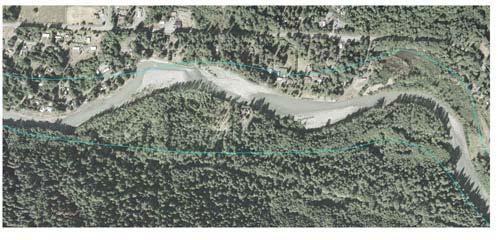
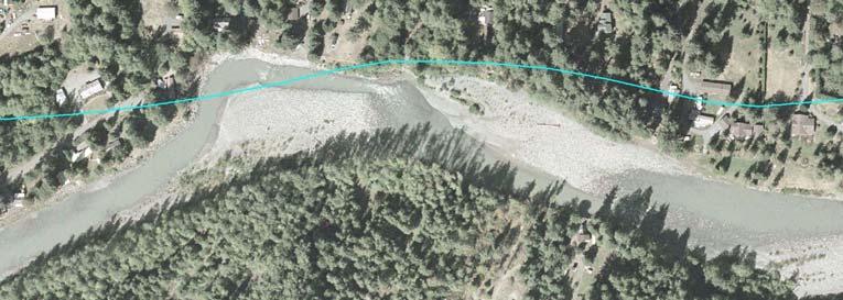
2 Channel and Bar Width and Active Erosion Length (aerial photo and cross-section) section) BAR RIVER Length DON. ft. ft. ft. ft. ft. ft. WILSON BARKER WILSON TANN. N. WILSON DILL KILCHIS L. GOM KILCHIS M. GOM KILCHIS
3 Average Erosion Rates BAR RATE RATE RATE RATE RATE ft./yr. ft./yr. ft./yr. ft./yr. ft./yr. DONALD BARKER DILL L. GMS M. GMS
4 Accelerated Cont. Recognizing Stages II, III and IV in CEM Headcuts

5 Echo Creek, UT Stage II after Straightening to accommodate Highway

6 Echo Creek, UT End of Bridge Apron

7 Echo Creek UT Downstream at Stage III to IV Trying to Meander & Develop F. P.
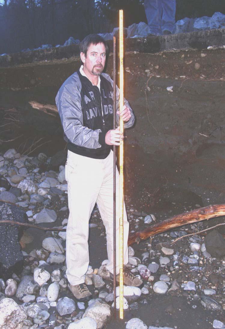
8 Accelerated Erosion Cont. Scour Under Tree Roots Increases Significantly from Year to Year Trees Actively Slumping Into Stream No Sediment Deposits (scour regime) Vertical Side Slope Sloughed Material Readily Removed Slumping Trees FIASC

9 Vertical Side Slope and No Sediment at Base of Slope Miami River OR
10 Accelerated Erosion Cont. Cultural Features Exposed (later) Ground Photograph Comparison (later) Bank Pins (later) Will Stream Transport Sediment Load (transport limited and easier to erode streambank than transport coarse sediment load)
11 What are the Reach Specific Mass Failure and Fluvial Causes of Streambank Erosion These Tend to Work in Combination with Each-Other
12 Mass Failure-Flow Flow Causes of Streambank Erosion Bank Materials (composition and stratigraphy), Height, Overhang, High Pore Pressure, Seepage Forces, Liquefaction, Upwelling Flow, Rotational and Planer Failure. Boundary Shear Stress or Tractive Stress (especially washing out soft layers or matrix material in gravels)
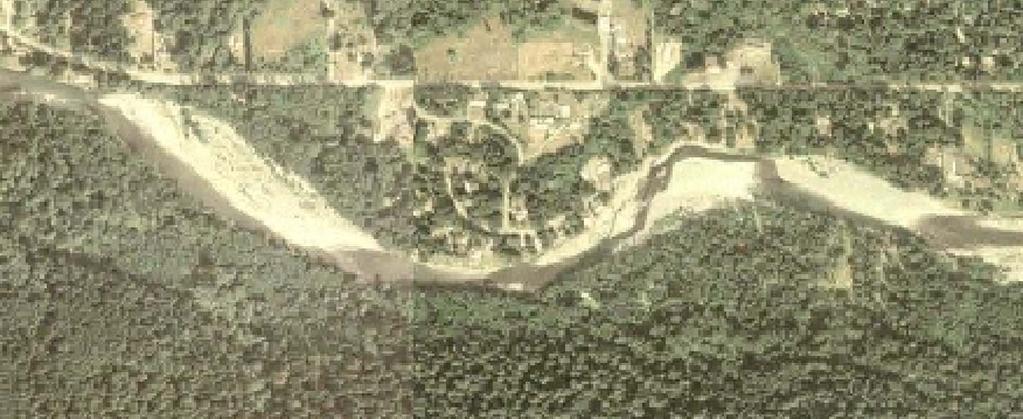
13 How are Rates of Streambank Erosion Determined Aerial Photograph Comparison

14 South Fork Stillaguamish 1963 &2003

15
16 Measurement of bank profiles. Real-time validation of bank loss (recession). Considered validation. Add representative streambank distance on profile to derive volume. If representation is in question, add more bank profiles!
17 Bank Pins

18 South Fork Stillaguamish Bank Loss Pins and Cultural Features
19 Rates Cont. Reference to cultural or known features and or ground photographs comparison.

20 Cultural Features S.F. Stillagaumish

21 Cultural Features Stillaguamish

22 Cultural Features Little Washougal, WA

23 Cultural Feature Right of Way Fence Stage III
24 VARIOUS RATING PROCEDURES ROSGEN (Bank Erosion Hazard Index, see Section Six in Binder) RECKENDORF (Erosion Rating Index) RECKENDORF RAPFAHRS (Rapid( Assessment Procedure For Aquatic Habitat, Riparian and Stream Bank see Section Six in Binder) RAPFAHRS (example in Walla Walla Basin, WA)
25 Data Needs FLUVIAL-GEOMORPHIC DATA ARE NEEDED TO EVALUATE: STREAMBANK EROSION PROBLEMS, AND SOLUTIONS
26 Fluvial-Geomorphic Data Needed Erosion Rate Establish Accelerated Erosion Bankfull Discharge Gage Data (peak verses mean daily) Regional Curves (Leopold Example) Manning Equation Continuity Equation Regional Equat.. like USGS, & ORWRD Establish Bankfull indicators to Determine Width, Depth and Area, and Estimate Velocity
27 Manning s equation v n 1 2 Where: r s A r = = WP s = ft ft ft ft 2 hydraulic radius rise divided by run n = mannings roughness coefficient n, which is dimensionless Q = a v Where: a = area in ft 2 v = velocity in fps
28 What Is Bankfull By definition, the flow in a stream goes over bank and floods when it exceeds bankfull. Leopold defined as the first flat depositional surface formed by the stream and flooded by the stream at a frequent interval The recurrence interval for bankfull flow is very frequent, and has been reported in the literature to have between a 1.0 and 3.0 year average recurrence interval.
29 Bankfull Cont. Recent studies in the Northwest indicate that the bankfull frequency is between 1.0 and 1.5 years in average recurrence interval. At the 1.5 year average recurrence interval, a stream gets out of bank two out of three years, or with a 67% chance that the stream will get out of bank in any one year.
30 Bankfull Cont. The bankfull surface of a stream is not always is not always the top of a streams bank, especially where there are multiple flood plains and terrace surfaces (to be illustrated later)
31 Bankfull Cont. Do to natural and anthropogenic caused downcutting and widening the stream can become entrenched and contain flood events within its banks. In rare situations (do to deteriorated watershed conditions) streams can become entrenched because of excessive sedimentation of the flood plain (see Trimble, 1981, Southwestern Wisconsin).

32 Six Mile Crk, Fritz Durst Farm, Dane Co, WI (38 mi 2 ) Bankfull indicators above water surface: lowest encroachment of woody vegetation & washed
33 Six Mile Creek, Fritz Durst Farm, Dane Co, WI (38 mi 2 ) Data From Two Different Classes Average bankfull channel dimensions: W = 23 D = 2.3 W/D = 10 ER >2.2 Rosgen E4/5 & CEM Stage I W = 24, D = 2.4 W/D = 10 ER >2.2 Rosgen E4/5 & CEM Stage I

34 Yahara River, Deforest, Dane Co, WI (47 mi 2 ) slope break & 1st flat, depositional surface = bankfull surface 10/16/01
 abandoned floodplain surface (#3) flood prone surface")
35 Yahara River, Deforest, Dane Co, WI (47 mi 2 ) Twice Max. Bankfull Depth upland surface (#4) abandoned floodplain surface (#3) flood prone surface (#2) bankfull surface (Surface #1)
36 Hydraulic Geometry (Bankfull Channel Dimensions) Madison, WI Vicinity (based on field measurements made 10/16-18 and 10/23-25/01) Bankfull Q (Mannings) y = x 0.52 R 2 = Width, Depth, Area, Bankfull Q (feet, feet, square feet, cfs) Cross Section Area y = x 0.55 R 2 = y = x 0.22 R 2 = Depth Width y = x 0.32 R 2 = Drainage Area (square miles) Sample Regional Curve for Streams Near Madison, WI

37 Bankfull Discharge Leopold Regional Curve

38 Regional Bankfull Dimensions Leopold (1978)
39 Regional Curve WI Hydraulic Geometry (Bankfull Channel Dimensions) Madison, WI Vicinity (based on fi 10/16-18 and 10/23-25/01) Bankfull Q (Mann y = x R 2 = Cross Section A y = x R 2 = Widt y = x R 2 = y = x R 2 = Dept Drainage Area (square

40 Regional Curve in Arizona
41 BANKFULL FIELD EVIDENCE OR INDICATORS 1. The first flat depositional surface above the active channel. 2. The lowest extent of woody vegetation along the edge of the streambank. 3. The top of the zone of washed roots (roots exposed in the bank)
42 BANKFULL INDICATORS CONTINUED 4. A break in the slope angle of the streambank. 5. The tops of the point bars or other sediment deposits (This is typically considered the lowest elevation to be considered as potentially the bankfull surface.) 6. The average elevation of the highest surface of the channel bars.
43 BANKFULL INDICATORS CONTINUED 7. The elevation of the upper limit of sand sized particles in the boundary sediment. 8. The elevation at which the width/depth ratio of the cross-section section is a minimum (requires plotting cross-section). section). 9. The elevation corresponding to the change in the relation of cross-sectional sectional area to top width. (from graph) 10. The elevation of float debris if used in combination with other features. 11. The area of washed rock if used in combination with the six other features.

44 Bankfull Top of Washed Root Zone

45 Bankfull Flood Plain
46 Fluvial-Geomorphic Data Needs (Continued) Other Appropriate Discharges and Frequencies (Applegate River example where needed to know effects of a specific flood) Discharge Distribution HEC-RAS
47 Fluvial Geomorphic Conditions Continued Bankfull Width (see cartoon example) Bankfull Depth (see cartoon example) Entrenchment Ratio Stream Slope (see cartoon example) Stream Sinuosity (see formula and example)

48 Bankfull Width and Depth Ratio & Entrenchment Ratio

49 Stream Slope
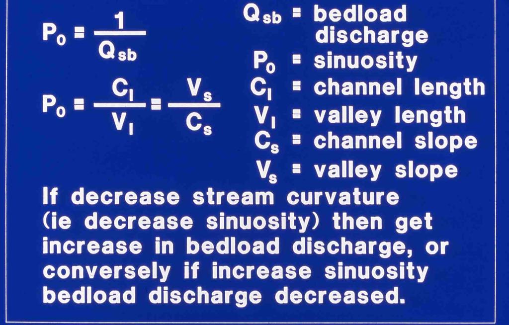
50 Sinuosity

51 Echo Cr. Sinuosity
52 Fluvial Geomorphic Conditions Continued Stream Bed Material Class (see Section Eight in Binder, and photographs) Rosgen Stream Classification System (see Section Seven, and Key to Classification)

53 Stream Geometry a = amplitude λ = a= wavelength b = beltwidth r = radius of curvature w = bankfull width at inflection point z = arc length (stream length between successive inflection points, i

54 Bed Material Class see Sec. 8 Alternative is Gravelometer for particle class to get d50
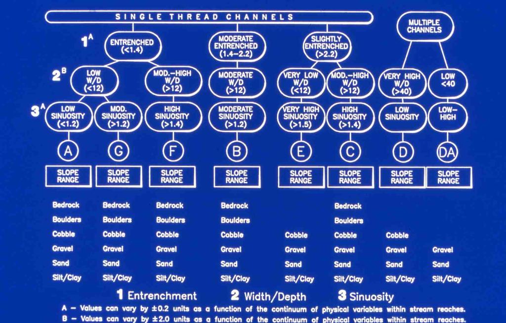
55 Rosgen Stream Classification
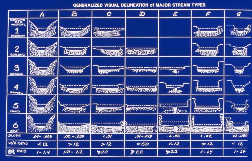
56 Rosgen Stream Classification
57 CONDITIONS CONT. Streambank Materials Streambank Stratigraphy Streambank Height Stream Side-slope CEM Streambank Stability Class Describe Mass Failure Observed (planer or rotational; preferential and or pop out) Streambank Stability Sampling for Soil Mechanics Analysis (? Rare Case) Stream Planform Condition (examples)
58 Stream Planform Montgomery and Buffington

59 5 Stages of CEM (Schumm et al) (Figure 1.1 from Schumm et al, 1981)

60 M & B Planform Types
61 M & B Interpretations

62 M & B Example Interpret.
63 CONDITIONS CONT. Vegetation (native and exotic examples) Vegetation Overhang (examples) Tree Overhang Tree Throw (examples) Backchannels (example) Upstream and Downstream Sedimentation LWD in Channel and on Bars
64 Conclusions Field data used for stream classification are most useful if it is used in both evaluation and in design. This is true for both Rosgen and CEM (Schumm et al. & Simon) stream classification systems.
65 Conclusions (Continued) The Rosgen, Schumm et al. (& Simon) and Montgomery and Buffington classification systems are complimentary even though they use different terminology. All three systems are broadly applicable.
66 Conclusions (continued) The Rosgen Stream Classification System is the most practical and applicable stream classification ever developed. It has no equal in terms of communication of what a stream looks like. However people do need training in its use particularly in how to identify bankfull stage for various stream types. Regional curves can be developed for bankfull depth, width, cross-sectional sectional area and discharge. Regional bankfull curves are and excellent tool to establish depositional features and their associated bankfull indicators in the field
67 Conclusions (Continued) The Rosgen Stream Classification System reflects both morphology and process. Rosgen s stream classification system is based on geomorphic measurements and indicators taken at bankfull discharge. The term bankfull discharge is sometimes used interchangeably with the term effective discharge and/or the term channel-forming flow; yet, their meanings are distinct and should be explained as such because under specific circumstances such as channel incision, bankfull discharge and effective discharge may vary significantly.
68 Conclusion (Continued) It is believed that the discharge or flow at the bankfull is most effective to carry sediments overtime (Leopold, 1994). Though the formation process of a natural channel is complex, there are quantifiable and consistent patterns for the process, especially at the bankfull stage (Leopold et al., 1964).
69 Conclusions (Continued) When Rosgen Stream Classification System is used in concert with the Schumm et al. CEM or the Simon CEM that reflect process and trend, one has an outstanding combination available for streambank practitioners.
OBJECTIVES. Fluvial Geomorphology? STREAM CLASSIFICATION & RIVER ASSESSMENT
 STREAM CLASSIFICATION & RIVER ASSESSMENT Greg Babbit Graduate Research Assistant Dept. Forestry, Wildlife & Fisheries Seneca Creek, Monongahela National Forest, West Virginia OBJECTIVES Introduce basic
Stream Classification
 Stream Classification Why Classify Streams? Communication Tool Describe Existing Conditions & Trends Describe Restoration Goals Research Tool Morphologic Stream Classification Systems Schumm (1977) Alluvial
Fluvial Geomorphology
 Geomorphic Components of Riparian Ecosystems W. Barry Southerland, Ph.D. Fluvial Geomorphologist, CPESC #514 West National Technology Support Center Water Quality and Quantity Technology Development Team
Why Stabilizing the Stream As-Is is Not Enough
 Why Stabilizing the Stream As-Is is Not Enough Several examples of alternatives to the County s design approach have been suggested. A common theme of these proposals is a less comprehensive effort focusing
Riparian Assessment. Steps in the right direction... Drainage Basin/Watershed: Start by Thinking Big. Riparian Assessment vs.
 Riparian Assessment vs. Monitoring Riparian Assessment What is a healthy stream? Determine stream/riparian health Determine change or trend, especially in response to mgmt Classification = designation
Why Geomorphology for Fish Passage
 Channel Morphology - Stream Crossing Interactions An Overview Michael Love Michael Love & Associates mlove@h2odesigns.com (707) 476-8938 Why Geomorphology for Fish Passage 1. Understand the Scale of the
May 7, Roger Leventhal, P.E. Marin County Public Works Laurel Collins Watershed Sciences
 May 7, 2013 Roger Leventhal, P.E. Marin County Public Works Laurel Collins Watershed Sciences Background Funded in 2009 under EPA 2100 Grant for $30k and managed by SFEP Project Goals: Update original
CR AAO Bridge. Dead River Flood & Natural Channel Design. Mitch Koetje Water Resources Division UP District
 CR AAO Bridge Dead River Flood & Natural Channel Design Mitch Koetje Water Resources Division UP District Old County Road AAO Bridge Map courtesy of Marquette County Silver Lake Basin McClure Basin
Aquifer an underground zone or layer of sand, gravel, or porous rock that is saturated with water.
 Aggradation raising of the streambed by deposition that occurs when the energy of the water flowing through a stream reach is insufficient to transport sediment conveyed from upstream. Alluvium a general
NATURE OF RIVERS B-1. Channel Function... ALLUVIAL FEATURES. ... to successfully carry sediment and water from the watershed. ...dissipate energy.
 1 2 Function... Sevier River... to successfully carry sediment and water from the watershed....dissipate energy. 3 ALLUVIAL FEATURES 4 CHANNEL DIMENSION The purpose of a stream is to carry water and sediment
Overview of fluvial and geotechnical processes for TMDL assessment
 Overview of fluvial and geotechnical processes for TMDL assessment Christian F Lenhart, Assistant Prof, MSU Research Assoc., U of M Biosystems Engineering Fluvial processes in a glaciated landscape Martin
NATURAL RIVER. Karima Attia Nile Research Institute
 NATURAL RIVER CHARACTERISTICS Karima Attia Nile Research Institute NATURAL RIVER DEFINITION NATURAL RIVER DEFINITION Is natural stream of water that flows in channels with ih more or less defined banks.
Tom Ballestero University of New Hampshire. 1 May 2013
 Tom Ballestero University of New Hampshire 1 May 2013 1 Hydrology 2 Basic Hydrology Low flows most common Flows that fill the stream to the banks and higher are much less common Filling the stream to the
PolyMet NorthMet Project
 RS 26 Draft-01 December 8, 2005 RS26 Partridge River Level 1 Rosgen Geomorphic Survey Rosgen Classification Partridge River from Headwaters to Colby Lake Prepared for PolyMet NorthMet Project December
Business. Meteorologic monitoring. Field trip? Reader. Other?
 Business Meteorologic monitoring Field trip? Reader Other? Classification Streams Characterization Discharge measurements Why classify stream channels? Why Classify Stream Channels? Provides a common language
Step 5: Channel Bed and Planform Changes
 Step 5: Channel Bed and Planform Changes When disturbed, streams go through a series of adjustments to regain equilibrium with the flow and sediment supply of their watersheds. These adjustments often
Avoiding Geohazards in the Mid-Atlantic Highlands by Using Natural Stream Principles
 Avoiding Geohazards in the Mid-Atlantic Highlands by Using Natural Stream Principles J. Steven Kite, WVU Neal Carte, WVDOT Will Harman, Michael Baker Corp. Donald D. Gray, WVU Photo: W. Gillespie North
Appendix E Rosgen Classification
 Appendix E Stream Type s Using the morphometric parameters described above, stream reaches are classified into 7 major stream types (Aa+ through G) based on s (1996) criteria. The relevant stream classifications
Limitation to qualitative stability indicators. the real world is a continuum, not a dichotomy ~ 100 % 30 % ~ 100 % ~ 40 %
 Stream Stability Assessment & BEHI Surveys Joe Rathbun MDEQ Water Resources Division rathbunj@michigan.gov 517--373 517 373--8868 Stability Stream can transport its water and sediment inputs without changing
Diagnostic Geomorphic Methods for Understanding Future Behavior of Lake Superior Streams What Have We Learned in Two Decades?
 Diagnostic Geomorphic Methods for Understanding Future Behavior of Lake Superior Streams What Have We Learned in Two Decades? Faith Fitzpatrick USGS WI Water Science Center, Middleton, WI fafitzpa@usgs.gov
Bank Erosion and Morphology of the Kaskaskia River
 Bank Erosion and Morphology of the Kaskaskia River US Army Corps Of Engineers St. Louis District Fayette County Soil and Water Conservation District Team Partners : Carlyle Lake Ecosystem Partnership Vicinity
Rosgen Classification Unnamed Creek South of Dunka Road
 Rosgen Classification Unnamed Creek South of Dunka Road Prepared for Poly Met Mining Inc. September 2013 Rosgen Classification Unnamed Creek South of Dunka Road Prepared for Poly Met Mining Inc. September
Fish Passage at Road Crossings
 Fish Passage at Road Crossings 1 Crossing Design Workshop Outline 1:00 to 2:00 Intro, Design Overview, Channel Width 2:00 to 2:15 Break 2:15 to 3:15 No-Slope, Stream Simulation Design 3:15 to 3:30 Break
Field Methods to Determine/ Verify Bankfull Elevation, XS Area & Discharge
 Module # 6 Field Methods to Determine/ Verify Bankfull Elevation, XS Area & Discharge Iowa s River Restoration Toolbox Level 1 / Base Training Overview of Basic Field Data Collection Site Map Cross Sections
Assessment. Assessment
 2001 SPRINGBROOK CREEK RESTORATION - THREE YEAR POST-CONSTRUCTION REVIEW - Presented by Bruce Henderson and Andy Harris 2005 River Restoration Northwest Symposium Skamania Lodge, Washington www.hendersonlandservices.com
ADDRESSING GEOMORPHIC AND HYDRAULIC CONTROLS IN OFF-CHANNEL HABITAT DESIGN
 ADDRESSING GEOMORPHIC AND HYDRAULIC CONTROLS IN OFF-CHANNEL HABITAT DESIGN Conor Shea - Hydrologist U.S. Fish and Wildlife Service Conservation Partnerships Program Arcata, CA Learning Objectives Examine
CASE STUDIES. Introduction
 Introduction The City of Winston-Salem faces the challenge of maintaining public infrastructure (e.g., water and sewer lines, storm drains, roads, culverts and bridges) while minimizing the potential impacts
Implementing a Project with 319 Funds: The Spring Brook Meander Project. Leslie A. Berns
 Implementing a Project with 319 Funds: The Spring Brook Meander Project Leslie A. Berns "...to acquire... and hold lands... for the purpose of protecting and preserving the flora, fauna and scenic beauties...
!"#$%&&'()*+#$%(,-./0*)%(!
*+#$%(,-./0*)%(!") 8:30 Sign in Hoosic River Revival Coalition!"#$%&&'()*+#$%(,-./0*)%(! 12-#30+4/#"5-(60 9:00 Welcome and Introductions 9:15 Goals for Today s Program: A Description of the Planning Process 9:30 First Session:
8:30 Sign in Hoosic River Revival Coalition!"#$%&&'()*+#$%(,-./0*)%(! 12-#30+4/#"5-(60 9:00 Welcome and Introductions 9:15 Goals for Today s Program: A Description of the Planning Process 9:30 First Session:
Dolores River Watershed Study
 CHAPTER 4: RIVER AND FLOODPLAIN ISSUES The Dolores River falls into a category of streams in Colorado that share some unique characteristics. Like some other mountain streams in the state, it has a steep
Discharge. Discharge (Streamflow) is: Q = Velocity (L T -1 ) x Area (L 2 ) Units: L 3 T -1 e.g., m 3 s -1. Velocity. Area
 is: Q = Velocity (L T -1 ) x Area (L 2 ) Units: L 3 T -1 e.g., m 3 s -1. Velocity. Area") Discharge Discharge (Streamflow) is: Q = Velocity (L T -1 ) x Area (L 2 ) Units: L 3 T -1 e.g., m 3 s -1 Velocity Area Where is the average velocity?? 3 Source: Brooks et al., Hydrology and the Management
Discharge Discharge (Streamflow) is: Q = Velocity (L T -1 ) x Area (L 2 ) Units: L 3 T -1 e.g., m 3 s -1 Velocity Area Where is the average velocity?? 3 Source: Brooks et al., Hydrology and the Management
The how, why, and lessons learned
 The how, why, and lessons learned emulates natural river systems integrates fluvial processes over temporal and spatial scales of self-formed and self-maintained natural rivers reestablish the physical,
Stream Geomorphology. Leslie A. Morrissey UVM July 25, 2012
 Stream Geomorphology Leslie A. Morrissey UVM July 25, 2012 What Functions do Healthy Streams Provide? Flood mitigation Water supply Water quality Sediment storage and transport Habitat Recreation Transportation
Application of Fluvial Geomorphologic Techniques At Abandoned Mine Sites 1. David A. Greenfield 2 Dennis M. Palladino 3
 Application of Fluvial Geomorphologic Techniques At Abandoned Mine Sites 1 David A. Greenfield 2 Dennis M. Palladino 3 ABSTRACT Watersheds that have been severely impacted by mining can no longer transport
Probabilistic Evaluation of a Meandering Low-Flow Channel. February 24 th, UMSRS
 Probabilistic Evaluation of a Meandering Low-Flow Channel February 24 th, 2014 2014 UMSRS 1 2 acknowledgments Low- Flow Channel (LFC) overview Proposed Diversion Channel collects runoff from: The Rush
Watershed Assessment of River Stability and Sediment Supply: Advancing the Science of Watershed Analysis
 Watershed Assessment of River Stability and Sediment Supply: Advancing the Science of Watershed Analysis 2009 MWEA Annual Conference Rob Myllyoja, CET rmyllyoja@hrc-engr.com Watershed Assessment of River
A GEOMORPHOLOGICAL APPROACH TO RESTORATION OF INCISED RIVERS. David L. Rosgen 1
 Proceedings of the Conference on Management of Landscapes Disturbed by Channel Incision, 1997 S.S.Y. Wang, E.J. Langendoen and F.D. Shields, Jr. (eds.) ISBN 0-937099-05-8 A GEOMORPHOLOGICAL APPROACH TO
Carmel River Bank Stabilization at Rancho San Carlos Road Project Description and Work Plan March 2018
 Carmel River Bank Stabilization at Rancho San Carlos Road Project Description and Work Plan March 2018 EXISTING CONDITION The proposed Carmel River Bank Stabilization at Rancho San Carlos Road Project
Geomorphic Importance of Winter Peak Flows and Annual Snowmelt Hydrographs in a Sierra Nevada Boulder-Bedrock River
 Geomorphic Importance of Winter Peak Flows and Annual Snowmelt Hydrographs in a Sierra Nevada Boulder-Bedrock River Scott McBain and Bill Trush McBain & Trush, Inc. Clavey River and Cherry Creek vicinity
Rapid Geomorphic Assessments: RGA s
 Establishing Current Reference Conditions Rates and concentrations of suspended-sediment transport vary over time and space due to factors such as precipitation characteristics and discharge, geology,
Upper Truckee River Restoration Lake Tahoe, California Presented by Brendan Belby Sacramento, California
 Upper Truckee River Restoration Lake Tahoe, California Presented by Brendan Belby Sacramento, California Mike Rudd (Project Manager), Charley Miller & Chad Krofta Declines in Tahoe s Water Clarity The
Geomorphology Geology 450/750 Spring Fluvial Processes Project Analysis of Redwood Creek Field Data Due Wednesday, May 26
 Geomorphology Geology 450/750 Spring 2004 Fluvial Processes Project Analysis of Redwood Creek Field Data Due Wednesday, May 26 This exercise is intended to give you experience using field data you collected
Geomorphology Studies
 Geomorphology Studies Technical Workgroup Meeting February 14, 2012 Prepared by: Tetra Tech Prepared for: Alaska Energy Authority Overall Goal Geomorphology Studies Two studies Geomorphology Study (RSP
Erosion Rate is a Function of Erodibility and Excess Shear Stress = k ( o - c ) From Relation between Shear Stress and Erosion We Calculate c and
 From Relation between Shear Stress and Erosion We Calculate c and") Equilibrium, Shear Stress, Stream Power and Trends of Vertical Adjustment Andrew Simon USDA-ARS, Oxford, MS asimon@msa-oxford.ars.usda.gov Non-Cohesive versus Cohesive Materials Non-cohesive: sands and
Equilibrium, Shear Stress, Stream Power and Trends of Vertical Adjustment Andrew Simon USDA-ARS, Oxford, MS asimon@msa-oxford.ars.usda.gov Non-Cohesive versus Cohesive Materials Non-cohesive: sands and
GEOL 1121 Earth Processes and Environments
 GEOL 1121 Earth Processes and Environments Wondwosen Seyoum Department of Geology University of Georgia e-mail: seyoum@uga.edu G/G Bldg., Rm. No. 122 Seyoum, 2015 Chapter 6 Streams and Flooding Seyoum,
Four Mile Run Levee Corridor Stream Restoration
 Four Mile Run Levee Corridor Stream Restoration 30% Design Summary U.S. Army Corps of Engineers, Baltimore District Presentation Outline Four Mile Run 1.) Historic Perspective 2.) Existing Conditions 3.)
Annotated Bibliography of River Avulsions Pat Dryer Geography 364 5/14/2007
 Annotated Bibliography of River Avulsions Pat Dryer Geography 364 5/14/2007 1 Table of Contents Introduction 2 Annotations I. River avulsions and their deposits 2 II. Channel avulsion on alluvial fans
Do you think sediment transport is a concern?
 STREAM RESTORATION FRAMEWORK AND SEDIMENT TRANSPORT BASICS Pete Klingeman 1 What is Your Restoration Project Like? k? Do you think sediment transport is a concern? East Fork Lewis River, WA Tidal creek,
GENERAL SUMMARY BIG WOOD RIVER GEOMORPHIC ASSESSMENT BLAINE COUNTY, IDAHO
 GENERAL SUMMARY BIG WOOD RIVER GEOMORPHIC ASSESSMENT BLAINE COUNTY, IDAHO Prepared For Trout Unlimited 300 North Main Street, Hailey, Idaho, 83333 Prepared By P. O. Box 8578, 140 E. Broadway, Suite 23,
Fluvial Geomorphic Guidelines
 Fluvial Geomorphic Guidelines FACT SHEET I: GEOMORPHOLOGICAL HAZARDS CONFINED AND UNCONFINED WATERCOURSES Channel migration and erosion can create substantial risk to inappropriately located infrastructure
GEOL 652. Poudre River Fieldtrip
 GEOL 652. Poudre River Fieldtrip One of the more difficult variables to measure and/or estimate when studying flow in natural channels is that of roughness. Roughness, usually approximated with Manning
Diego Burgos. Geology 394. Advisors: Dr. Prestegaard. Phillip Goodling
 Sediment Transport into an Urban Tributary Junction Diego Burgos Geology 394 Advisors: Dr. Prestegaard Phillip Goodling 1 Abstract Tributary junctions are an important component of stream morphology and
Technical Memorandum. To: From: Copies: Date: 10/19/2017. Subject: Project No.: Greg Laird, Courtney Moore. Kevin Pilgrim and Travis Stroth
 Technical Memorandum To: From: Greg Laird, Courtney Moore Kevin Pilgrim and Travis Stroth 5777 Central Avenue Suite 228 Boulder, CO 80301 www.otak.com Copies: [Electronic submittal] Date: 10/19/2017 Subject:
River floodplain regime and stratigraphy. Drs. Nanette C. Kingma.
 River floodplain regime and stratigraphy. Drs. Nanette C. Kingma. Formation of floodplain. Formation of floodplains: lateral channel migration in channel deposition suspended-load fall out during higher
FUTURE MEANDER BEND MIGRATION AND FLOODPLAIN DEVELOPMENT PATTERNS NEAR RIVER MILES 200 TO 191 OF THE SACRAMENTO RIVER PHASE III REPORT
 FUTURE MEANDER BEND MIGRATION AND FLOODPLAIN DEVELOPMENT PATTERNS NEAR RIVER MILES 200 TO 191 OF THE SACRAMENTO RIVER PHASE III REPORT Eric W. Larsen REPORT FOR DUCKS UNLIMITED March 31, 2006-1 - Contents
River Morphology. EAD 511 River management
 River Morphology EAD 511 River management Introduction FLUVIAL GEOMORPHOLOGY Webster's New World Dictionary defines fluvial as: of, found in, or produced by a river or rivers. The same reference defines
Stream Restoration and Environmental River Mechanics. Objectives. Pierre Y. Julien. 1. Peligre Dam in Haiti (deforestation)
") Stream Restoration and Environmental River Mechanics Pierre Y. Julien Malaysia 2004 Objectives Brief overview of environmental river mechanics and stream restoration: 1. Typical problems in environmental
Stream Restoration and Environmental River Mechanics Pierre Y. Julien Malaysia 2004 Objectives Brief overview of environmental river mechanics and stream restoration: 1. Typical problems in environmental
Session C1 - Applying the Stream Functions Pyramid to Geomorphic Assessments and Restoration Design
 University of Massachusetts - Amherst ScholarWorks@UMass Amherst International Conference on Engineering and Ecohydrology for Fish Passage International Conference on Engineering and Ecohydrology for Fish
4 CHANNEL HABITAT TYPING
 Upper Williamson River Watershed Assessment 4 CHANNEL HABITAT TYPING INTRODUCTION METHODS Classification of stream channels within a watershed is an important part of understanding the inherent spatial
APPENDIX A REACH DECRIPTIONS. Quantico Creek Watershed Assessment April 2011
 APPENDIX A REACH DECRIPTIONS Basin 615, South Fork of Quantico Creek - Project Reach Descriptions Reach Name: 615-A Coordinates (NAD 83, Virginia State Plane North): 11796510.57, 6893938.95 to 11801555.79,
Technical Memorandum No Sediment Model
 Pajaro River Watershed Study in association with Technical Memorandum No. 1.2.9 Sediment Model Task: Development of Sediment Model To: PRWFPA Staff Working Group Prepared by: Gregory Morris and Elsie Parrilla
SELBY CREEK STREAM HABITAT RESTORATION AND RIPARIAN REVEGETATION PROJECT: GEOMORPHIC ANALYSIS AND REVIEW
 SELBY CREEK STREAM HABITAT RESTORATION AND RIPARIAN REVEGETATION PROJECT: GEOMORPHIC ANALYSIS AND REVIEW Submitted to Bioengineering Institute P.O. Box 1554 Laytonville, CA 95454 By Matthew O Connor, PhD,
FINAL GEOMORPHIC ASSESSMENT REPORT BIG WOOD RIVER BLAINE COUNTY, IDAHO
 FINAL GEOMORPHIC ASSESSMENT REPORT BIG WOOD RIVER BLAINE COUNTY, IDAHO Prepared For Trout Unlimited 300 North Main Street, Hailey, Idaho, 83333 Prepared By P. O. Box 8578, 140 E. Broadway, Suite 23, Jackson,
Stream Entrainment, Erosion, Transportation & Deposition
 Lecture 12 Zone 2 of the Fluvial System, Continued Stream Entrainment, Erosion, Transportation & Deposition Erosion in a Fluvial Landscape Corrosion Chemical Erosion Corrasion Mechanical Weathering Cavitation
HAW CREEK, PIKE COUNTY, MISSOURI-TRIB TO SALT RIVER ERODING STREAM THREATHENING COUNTY ROAD #107, FOURTEEN FT TALL ERODING BANK WITHIN 4 FT OF THE
 HAW CREEK, PIKE COUNTY, MISSOURI-TRIB TO SALT RIVER ERODING STREAM THREATHENING COUNTY ROAD #107, FOURTEEN FT TALL ERODING BANK WITHIN 4 FT OF THE ROAD, PROJECT CONSTRUCTED IN 1 DAY, MARCH 10, 2009 BY
Appendix III-A Descriptions of Channel Habitat Types
 Appendix III-A Descriptions of Channel Habitat Types Table of Contents Channel Habitat Typing Background... 3 Small Estuarine Channel (ES)... 7 Large Estuarine Channel (EL)... 9 Low Gradient Large Floodplain
SCOPE OF PRESENTATION STREAM DYNAMICS, CHANNEL RESTORATION PLANS, & SEDIMENT TRANSPORT ANALYSES IN RELATION TO RESTORATION PLANS
 DESIGN METHODS B: SEDIMENT TRANSPORT PROCESSES FOR STREAM RESTORATION DESIGN PETER KLINGEMAN OREGON STATE UNIVERSITY CIVIL ENGINEERING DEPT., CORVALLIS 2 ND ANNUAL NORTHWEST STREAM RESTORATION DESIGN SYMPOSIUM
STREAM MODULES: SPREADSHEET TOOLS FOR RIVER EVALUATION, ASSESSMENT AND MONITORING **
 STREAM MODULES: SPREADSHEET TOOLS FOR RIVER EVALUATION, ASSESSMENT AND MONITORING ** D. E. Mecklenburg 1, A. Ward 2 Abstract Stream physical condition is increasingly a priority for resource managers.
Technical Supplement 3E. Rosgen Stream Classification Technique Supplemental Materials. (210 VI NEH, August 2007)
") Technical Supplement 3E (210 VI NEH, August 2007) Issued August 2007 Cover photo: The Rosgen stream classification system uses morphometric data to characterize streams. Advisory Note Techniques and approaches
Technical Supplement 3E (210 VI NEH, August 2007) Issued August 2007 Cover photo: The Rosgen stream classification system uses morphometric data to characterize streams. Advisory Note Techniques and approaches
APPENDIX B Hydraulic Considerations for Pipeline Crossings of Stream Channels
 APPENDIX B Hydraulic Considerations for Pipeline Crossings of Stream Channels B-1 B-2 APPENDIX B HYDRAULIC CONSIDERATIONS FOR PIPELINE CROSSINGS OF STREAM CHANNELS Pipeline crossings of perennial, intermittent,
Perspectives on river restoration science, geomorphic processes, and channel stability
 Perspectives on river restoration science, geomorphic processes, and channel stability Stream Restoration Forum: Science and Regulatory Connections Andrew C. Wilcox Department of Geosciences University
Kaskaskia Morphology Study Headwaters to Lake Shelbyville
 Kaskaskia Morphology Study Headwaters to Lake Shelbyville KWA Mini Summit 5 March 2012 1 Kaskaskia Morphology Study Headwaters to Lake Shelbyville Conducted by U.S. Army Corps of Engineers, St. Louis District
GLG598 Surface Processes and Landform Evolution K. Whipple Fall 2012 VERDE RIVER: FLOW MECHANICS, ROUGHNESS, AND SHEAR STRESS
 VERDE RIVER: FLOW MECHANICS, ROUGHNESS, AND SHEAR STRESS This lab will introduce you to some common field techniques and some general understanding of the geomorphic processes operating in a stream. The
Streams. Stream Water Flow
 CHAPTER 14 OUTLINE Streams: Transport to the Oceans Does not contain complete lecture notes. To be used to help organize lecture notes and home/test studies. Streams Streams are the major geological agents
PR206 NARRATIVE Updated 16 June 2015
 PR206 NARRATIVE Updated 16 June 2015 Cross section PR206 was established in 1977 in a fairly straight reach of Powder River about a kilometer downriver of the Highway 212 bridge at Broadus. The section
Forest Service AOP Meeting Objectives of Stream Simulation: Examples and Talking Points
 Forest Service AOP Meeting Objectives of Stream Simulation: Examples and Talking Points Traci Sylte, P.E. Hydrology/Fluvial Geomorphology Lolo National Forest Is It True? Are Road Crossings a Dam with
Squaw Creek. General Information
 General Information is a tributary to the Salmon River. It enters the north side of the river about 0 miles downstream of North Fork, Idaho. The study reach is about a 30 ft length of stream about 2 miles
Field Observations and One-Dimensional Flow Modeling of Summit Creek in Mack Park, Smithfield, Utah
 Intermountain Center for River Rehabilitation and Restoration, Utah State University 31 July 2018 Field Observations and One-Dimensional Flow Modeling of Summit Creek in Mack Park, Smithfield, Utah I.
Working with Natural Stream Systems
 Working with Natural Stream Systems Graydon Dutcher Delaware County Soil & Water Conservation District Stream Corridor Management Program Tropical Storm Sandy October 29,2012 What is a Watershed?
River Restoration and Rehabilitation. Pierre Y. Julien
 River Restoration and Rehabilitation Pierre Y. Julien Department of Civil and Environmental Engineering Colorado State University Fort Collins, Colorado River Mechanics and Sediment Transport Lima Peru
Natural Shoreline Landscapes on Michigan Inland Lakes
 Natural Shoreline Landscapes on Michigan Inland Lakes Excerpts from Chapters 2 and 3 Photo Photo by Jane by Jane Herbert Herbert Did you know? Twenty-four species of amphibians, 25 species of reptiles,
PHYSICAL GEOGRAPHY. By Brett Lucas
 PHYSICAL GEOGRAPHY By Brett Lucas FLUVIAL PROCESSES Fluvial Processes The Impact of Fluvial Processes on the Landscape Streams and Stream Systems Stream Channels Structural Relationships The Shaping and
SECTION G SEDIMENT BUDGET
 SECTION G SEDIMENT BUDGET INTRODUCTION A sediment budget has been constructed for the for the time period 1952-2000. The purpose of the sediment budget is to determine the relative importance of different
The Importance of Riparian Vegetation in Channel Restoration: Moving Towards Quantification in Design
 The Importance of Riparian Vegetation in Channel Restoration: Moving Towards Quantification in Design Rob Millar Department of Civil Engineering The University of British Columbia "Nothing is as practical
MEANDER MIGRATION MODEL ASSESSMENT FOR THE JANUARY 2005 STORM, WHITMAN PROPERTY, SAN ANTONIO CREEK, VENTURA COUNTY, CALIFORNIA
 MEANDER MIGRATION MODEL ASSESSMENT FOR THE JANUARY 2005 STORM, WHITMAN PROPERTY, SAN ANTONIO CREEK, VENTURA COUNTY, CALIFORNIA Prepared by Eric Larsen, Ph.D. Mark Rains, Ph.D. October 2006 INTRODUCTION
Two-Stage Channel Design
 United States Department of Agriculture Natural Resources Conservation Service Stream Restoration Design Chapter 10 Issued August 2007 Cover photo: Low gradient, nonincising channels and ditches may be
STABILIZATION OF THE H&CT RAILWAY STONE DAM WALTER E. SKIPWITH, PE, JOYCE CRUM, AIA AND JOHN BAUMGARTNER, PE. Introduction.
 STABILIZATION OF THE H&CT RAILWAY STONE DAM WALTER E. SKIPWITH, PE, JOYCE CRUM, AIA AND JOHN BAUMGARTNER, PE I. A. Introduction General The Old Stone Dam is located in the upper reach of Cottonwood Creek
Geomorphic Assessment of the Lower Boise River, Idaho
 Geomorphic Assessment of the Lower Boise River, Idaho Prepared by: Rob Richardson, P.G. and James Guilinger February, 2015 0 Acknowledgements Special thanks to Ellen Berggren and staff at the Army Corps
What discharge (cfs) is required to entrain the D 84 (84 th percentile of sediment size distribution) in Red Canyon Wash?
 is required to entrain the D 84 (84 th percentile of sediment size distribution) in Red Canyon Wash?") Gregory Indivero 31 October 2011 What discharge (cfs) is required to entrain the D 84 (84 th percentile of sediment size distribution) in Red Canyon Wash? What discharge was required to deposit observed
Gregory Indivero 31 October 2011 What discharge (cfs) is required to entrain the D 84 (84 th percentile of sediment size distribution) in Red Canyon Wash? What discharge was required to deposit observed
LOMR SUBMITTAL LOWER NEHALEM RIVER TILLAMOOK COUNTY, OREGON
 LOMR SUBMITTAL LOWER NEHALEM RIVER TILLAMOOK COUNTY, OREGON Prepared for: TILLAMOOK COUNTY DEPARTMENT OF COMMUNITY DEVELOPMENT 1510-B THIRD STREET TILLAMOOK, OR 97141 Prepared by: 10300 SW GREENBURG ROAD,
Measuring Streambank Erosion Bank Profiles to more Robustly Estimate Recession Rates and Calibration of the AnnAGNPS-CEAP Model
 Measuring Streambank Erosion Bank Profiles to more Robustly Estimate Recession Rates and Calibration of the AnnAGNPS-CEAP Model Clare Prestwich, P.E. 1 & W. Barry Southerland, Ph.D. 2 Water Quality and
Erosion Surface Water. moving, transporting, and depositing sediment.
 + Erosion Surface Water moving, transporting, and depositing sediment. + Surface Water 2 Water from rainfall can hit Earth s surface and do a number of things: Slowly soak into the ground: Infiltration
The last three sections of the main body of this report consist of:
 Threatened and Endangered Species Geological Hazards Floodplains Cultural Resources Hazardous Materials A Cost Analysis section that provides comparative conceptual-level costs follows the Environmental
Upper Mississippi River Basin Environmental Management Program Workshop
 Presentation to the Upper Mississippi River Basin Environmental Management Program Workshop by Michael Rodgers River Engineer US Army Corps of Engineers, St. Louis District August 17, 2007 Engineering
Session 1 Healthy Streams Stream Hydraulics Natural Channel Design
 Session 1 Healthy Streams Stream Hydraulics Natural Channel Design Bill Brant Heart of America Flyfishers Black & Veatch Kansas City, MO February 21, 2014 http://www.bobswebspace.com Audience? What do
CHANNEL GEOMORPHIC RESPONSES TO DISTURBANCES ASSESSED USING STREAMGAGE INFORMATION
 CHANNEL GEOMORPHIC RESPONSES TO DISTURBANCES ASSESSED USING STREAMGAGE INFORMATION Kyle E. Juracek, Research Hydrologist, U.S. Geological Survey, Lawrence, KS, kjuracek@usgs.gov; Mark W. Bowen, Ph.D. candidate,
Estimating Scour. CIVE 510 October 21 st, 2008
 Estimating Scour CIVE 510 October 21 st, 2008 1 Causes of Scour 2 Site Stability 3 Mass Failure Downward movement of large and intact masses of soil and rock Occurs when weight on slope exceeds the shear
UPPER KETTLE CREEK FISH HABITAT CONSERVATION PLAN TRIBUTARIES ADDENDUM
 UPPER KETTLE CREEK FISH HABITAT CONSERVATION PLAN TRIBUTARIES ADDENDUM For: Kettle Creek Watershed Association and Trout Unlimited March 2005 1000 Commerce Park Drive Williamsport, PA 17701 Phone (570)
Chapter 3 Erosion in the Las Vegas Wash
 Chapter 3 Erosion in the Las Vegas Wash Introduction As described in Chapter 1, the Las Vegas Wash (Wash) has experienced considerable change as a result of development of the Las Vegas Valley (Valley).
High-Gradient Streams
 Chapter 4 Surface Processes Section 4 High-Gradient Streams What Do You See? Learning Outcomes In this section, you will Use models and real-time streamflow data to understand the characteristics of highgradient