Rosgen Classification Unnamed Creek South of Dunka Road
|
|
|
- Lisa Summers
- 5 years ago
- Views:
Transcription
1 Rosgen Classification Unnamed Creek South of Dunka Road Prepared for Poly Met Mining Inc. September 2013
2 Rosgen Classification Unnamed Creek South of Dunka Road Prepared for Poly Met Mining Inc. September West 77 th Street Minneapolis, MN Phone: (952) Fax: (952)
3 Rosgen Classification Unnamed Creek South of Dunka Road September 2013 Table of Contents 1.0 Introduction Description of Unnamed Creek Physical Classification of Channels Previous Studies Level I Rosgen Classification Data Collection Unnamed Creek Classification Conclusions... 5 References... 6 List of Figures Figure 1 Survey Area Along Unnamed Creek List of Appendices Appendix A Appendix B Rosgen Classification System Rosgen Level I Classification Data Sheets \\barr.com\projects\mpls\23 MN\69\ \WorkFiles\APA\Support Docs\Hydrology\West Pit Geomorph\Rosgen Level I Report West Pit Outlet Stream v1.docx i
4 1.0 Introduction The Minnesota Department of Natural Resources (MDNR), United States Forest Service Region 9 (USFS R9), and the United States Army Corps of Engineers (USACE), collectively known as the Co- Lead Agencies, are in the process of evaluating the environmental impacts of the NorthMet Project (Project). As part of the environmental review process, Poly Met Mining Inc. (PolyMet) has performed an evaluation of the geomorphology of the Unnamed Creek that drains a portion of the Mine Site to the Partridge River (also referred to as the West Pit Outlet stream). The purpose of this report is to summarize the findings of the stream geomorphology survey on Unnamed Creek conducted in November 2011 and discuss the sensitivity of the stream to changes in hydrology. 1.1 Description of Unnamed Creek Unnamed Creek is a perennial stream which drains the western portion of the Mine Site, including the future West Pit, to the Partridge River (Figure 1). This creek is not found on MDNR lists or figures of the public waters of Minnesota. The creek channel varies along its length from rocky riffles to open ponds created by low beaver dams. The headwaters of Unnamed Creek is a deep marsh immediately north of Dunka Road; there is little or no stream channel upstream of this marsh. The existing drainage area to this marsh consists largely of shrub forests, shrub swamps, and marshes. The land adjacent to Unnamed Creek before its confluence with the Partridge River is shrub swamps and shrub forests. The total length of Unnamed Creek is approximately 0.9 miles from its headwaters to the Partridge River. In November 2011, Barr Engineering conducted a survey of approximately 0.4 miles of Unnamed Creek in order to characterize the geomorphic characteristics of the channel and the floodplain. 1.2 Physical Classification of Channels Physical classification of a stream or river is the process of describing a stream s physical nature based on the relationship of its geometry and hydraulic characteristics. The purpose of a physical classification is to evaluate the stability of a stream under existing conditions, determine its sensitivity to change, and to indicate how restoration may be approached if a portion of the stream becomes unstable. The most commonly accepted system of physical classification is that developed by D.L. Rosgen (Reference (1), Reference (2)). The Rosgen system has eight basic stream types, which are further subdivided according to channel slope and materials. Furthermore, the classification is separated into levels, ranging from Level I (broad level characterization) to Level IV \\barr.com\projects\mpls\23 MN\69\ \WorkFiles\APA\Support Docs\Hydrology\West Pit Geomorph\Rosgen Level I Report West Pit Outlet Stream v1.docx 1
5 (verification of field measurements). A general description of the Rosgen classification system is presented in Appendix A. 1.3 Previous Studies Unnamed Creek was included in a hydrologic study performed for the Project in 2008 (Reference (3)) and updated in 2013 (Reference (4)). This study consisted of an XP-SWMM model of the entire Partridge River watershed above USGS gaging station # (Partridge River above Colby Lake). Unnamed Creek was included in this model, but channel cross-section and floodplain information were derived from aerial photography and GIS tools rather than a field survey. The XP-SWMM modeling, adjusted based on the observed flow record at the USGS gage (Table 4-7 of reference (4)), estimates that the average annual maximum flow rate of Unnamed Creek at the Dunka Road crossing is approximately 24 cfs, and the annual average flow rate is 1.6 cfs. This geomorphic study represents the first field data collected on Unnamed Creek for the NorthMet Project. \\barr.com\projects\mpls\23 MN\69\ \WorkFiles\APA\Support Docs\Hydrology\West Pit Geomorph\Rosgen Level I Report West Pit Outlet Stream v1.docx 2
6 2.0 Level I Rosgen Classification Barr Engineering performed a level I Rosgen Classification on Unnamed Creek in November The surveyed reaches are shown in Figure 1. A Level I classification consists of a survey of the channel profile and cross-sections of the channel and floodplain. See Appendix A for a general description of the Rosgen classification system and definition of terms used in this classification. The survey made some attempt to describe the substrate and bank materials, but no specific samples were collected. 2.1 Data Collection Barr conducted the survey of Unnamed Creek on November 16th, During the field survey, data was collected using survey-grade GPS. Ground photographs were also taken of each cross-section and at various points along the stream. The stream bottom profile was surveyed for a length of approximately 0.3 miles, and three permanent monumented cross-sections were established with 2 to 4 foot rebar stakes or nails in adjacent trees, lath and ribbon. Water surface elevations and bankfull elevation indicators were also surveyed, and the dominant bed material was described by visual inspection and photographs at several locations. 2.2 Unnamed Creek Classification The surveyed reach of Unnamed Creek is located south of Dunka Road, approximately 0.22 miles downstream of the road crossing and culvert. The measured physical parameters, cross-sections and photographs of this reach are shown in Appendix B, Data Sheet 1. In this area, Unnamed Creek meanders through forested wetlands with occasional low beaver dams that retard flow and increase water levels without creating large drops. Unnamed Creek is best characterized as a combination of Rosgen types C and E. Cross-section 1 is on the border between C and E classifications. This is due to its width/depth ratio of 10.6, which is near the value of 12 that divides C from E in the Rosgen classification system. Based on width/depth ratio alone, Cross-section 1 is an E channel, but its sinuosity is more typical of a C channel. Crosssection 2 has the width/depth ratio of a C channel, but the sinuosity of an E channel. Finally, Cross - section 3 is characterized as Type E. Reaches sometimes display characteristics of multiple channel types, and it is also possible for channel type to change along a reach. Changes in channel type are usually accompanied by changes in landscape factors such as slope or bed material. In the case of Unnamed Creek, the changes in \\barr.com\projects\mpls\23 MN\69\ \WorkFiles\APA\Support Docs\Hydrology\West Pit Geomorph\Rosgen Level I Report West Pit Outlet Stream v1.docx 3
7 substrate and the presence of beaver dams may be controlling influences on channel shape and plan form. In all sections, regardless of specific channel types,unnamed Creek is considered slightly entrenched and has a moderate to high degree of sinuosity. These characteristics indicate that the stream has an adequate floodplain to dissipate energy during higher-than-bankfull flows, and that it has reasonably frequent access to that floodplain. Baseflow in this creek from groundwater is very low and may occasionally be zero; the hydrologic model of the area estimates the average 30-day minimum flow at Dunka Road at approximately 0.1 cfs (Reference (4)). The wetland surrounding Unnamed Creek has been classified as an alder thicket (Reference (5)). Bank and floodplain vegetation along Unnamed Creek consists of emergent and wetland grasses and wetland shrubs. There are places where conifers and shrubs grow right up to the banks of the stream, but there is no evidence of significant bank undercutting or other erosion on this reach. The alder thicket wetland along the stream is bordered by a forest on both sides. Stream bed material consists of cobbles in riffles and runs and silty/mucky materials in ponds and pools. The classification of bank material is not well known but based on existing vegetation and previously classified wetland type it is likely to be predominantly silt. Downstream of the surveyed reach, in the 0.3 miles before its confluence with the Partridge River, Unnamed Creek maintains approximately the same plan view and floodplain characteristics as the surveyed reach. It is reasonable to expect that cross-sectional area increases moving downstream as the watershed area increases, but slope and entrenchment ratios are also likely consistent with that of the surveyed reach. With characteristics of both C and E channels, Unnamed Creek has moderate to high sensitivity to disturbances of the streambanks or significant changes in stream flow or sediment supply. As indicated in Table A-2, the influence of riparian vegetation on channel stability in all C and E streams is moderate to very high, meaning that streams with extensive vegetative root systems on the banks are more likely to maintain a stable cross-section. Because of the well-developed bank vegetation (100% coverage on the banks) and the noted presence of cobbles in the creek substrate, this reach is expected to be stable under moderate changes in stream flow and sediment supply. The recovery potential of this channel, should the banks be disturbed, is good. \\barr.com\projects\mpls\23 MN\69\ \WorkFiles\APA\Support Docs\Hydrology\West Pit Geomorph\Rosgen Level I Report West Pit Outlet Stream v1.docx 4
8 3.0 Conclusions This survey investigated Unnamed Creek, a tributary to the Partridge River from the NorthMet Mine Site, and found it to be consistent with Rosgen Type C and E streams. There is no evidence of erosion, downcutting, or channel widening at any of the surveyed locations along Unnamed Creek, and the creek has well-developed floodplains, substantial bank vegetation, and cobbles in the steeper riffle sections. Baseflow to Unnamed Creek from groundwater is very low, and water levels during average- and low-flow conditions are likely controlled by low beaver dams scattered throughout the wetlands. Because of the well-developed floodplains and complete coverage of the stream banks with wetland vegetation, Unnamed Creek is likely able to withstand moderate changes in hydrology with no significant degradation. The need for more detailed classification or monitoring of Unnamed Creek in the future should be based on the degree of proposed hydrologic changes in the creek s watershed. \\barr.com\projects\mpls\23 MN\69\ \WorkFiles\APA\Support Docs\Hydrology\West Pit Geomorph\Rosgen Level I Report West Pit Outlet Stream v1.docx 5
9 References 1. Rosgen, D.L. A Classification of Natural Rivers. 1994, 22, pp Applied River Morphology. Wildland Hydrology. Pogosa Springs, Colorado : s.n., Barr Engineering Company. Streamflow and Lake Level Changes, Hydrologic/Hydraulic Modeling Results for the PolyMet NorthMet Mine Site, RS73B Draft-03. September Poly Met Mining Inc. NorthMet Project Water Modeling Data Package Volume 1 - Mine Site (v12). March PolyMet Mining Inc. NorthMet Project Wetland Data Package. March \\barr.com\projects\mpls\23 MN\69\ \WorkFiles\APA\Support Docs\Hydrology\West Pit Geomorph\Rosgen Level I Report West Pit Outlet Stream v1.docx 6
10 Figures

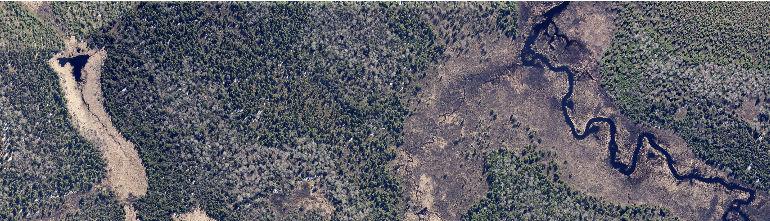
11 Dunka Road Barr Footer: ArcGIS 10.1, :36 File: I:\Client\PolyMet_Mining\Work_Orders\Agency_Preferred_Alternative\Maps\Support_Document\Water\Surface\West_Pit_Overflow_Survey_Memo\Figure 1 Survey Area Along Unnamed Creek.mxd User: arm2 Yelp Creek Unnamed Creek Partridge River Unnamed Creek Partri dge River Mine Site Unnamed Creek Survey Area Rivers and Streams Dunka Road I ,000 Feet Figure 1 SURVEY AREA ALONG UNNAMED CREEK NorthMet Project Poly Met Mining Inc Hoyt Lakes, Minnesota
12 Appendices
13 Appendix A Rosgen Classification System
14 Rosgen Classification System The classification system used to classify the stream channels was developed by D.L. Rosgen ( A Classification of Natural Rivers, Catena, 1994) Rosgen s classification system describes a stream on a reach-by-reach basis. A single stream can have several different stream types over its length. The system defines a stream type according to the shape, pattern, and profile of the reach. In particular, the following parameters are used to classify a stream type: the degree of entrenchment of the channel, the ratio of width to depth, degree of channel meandering or sinuosity, channel material, and the channel surface slope. Some of these parameters are illustrated on Figure A-1. The Rosgen classification system specifies seven basic stream types, ranging from A to G as shown on Figure A-2. Each type has six subclasses corresponding to the predominant bed material present in the reach. These subclasses are numbered from 1 to 6: 1 is bedrock, 2 is boulder, 3 is cobble, 4 is gravel, 5 is sand, and 6 is silt. This allows for 42 combinations of stream type. A description of the stream types is given in Table A-1. This table gives a range of values of the criteria used for stream classification. These ranges are those most commonly observed; the actual observed values can lie outside of these ranges to a certain extent, recognizing that as the stream type changes, the criteria will adjust accordingly. Entrenchment Ratio is defined as the ratio of the width of the flood-prone area to the bankfull surface width of the channel. Flood-prone area is defined by Rosgen as the width measured at an elevation which is determined at twice the maximum bankfull depth. Field observation shows this elevation to be a frequent flood (50 year) or less, rather than a rare flood elevation. The entrenchment ratio describes the interrelationship of the river to its valley and landform features. It is a measure of channel down-cutting compared to its floodplain. This interrelationship determines whether the river (stream) is deeply incised or entrenched in the valley floor or deposit feature. The entrenchment ratio indicates whether the flat area adjacent to the channel is a frequent floodplain, a terrace (abandoned floodplain), or is outside the floodprone area. Width/Depth Ratio is the ratio of bankfull channel width to bankfull mean depth; it is used to describe the dimension and shape of the channel. Sinuosity is the ratio of stream length to valley length. It can also be described as the ratio of valley slope to channel slope. This value typically varies from 1.0 to 2.5, where a value of 1.0 corresponds to a straight channel. Sinuosity can often be determined from aerial photographs, and interpretations can then be made of slope, channel materials, and entrenchment. Values of sinuosity appear to be modified by bedrock control, roads, channel confinement, and vegetation types, among other factors. Generally, as gradient and particle size decrease, there is a corresponding increase in sinuosity. Meander geometry characteristics are directly related to sinuosity following minimum expenditure of energy concepts. Based on these relations and ease of determination, sinuosity is one of the delineative criteria for stream classification.
15 Water Surface Slope is of major importance to the morphological character of the channel and its sediment, hydraulic, and biological function. It is determined by measuring the difference in water surface elevation per unit stream length. It is typically measured through at least 20 channel widths or two meander wavelengths (Rosgen). In broad level delineations, slope can be estimated by measuring sinuosity from aerial photos and measuring valley slope from topographic maps. Channel Materials refer to the bed and bank materials of the stream. Channel material is critical for sediment transport and hydraulic influences, and also modifies the form, plan, and profile of the stream. Interpretations of biological function and stability also require this information. The channel materials can often be estimated from soils maps and geologic information. They can also be determined in the field, and at the detailed level the materials are measured and the size plotted on percent distribution paper. Bankfull Discharge occurs at approximately the 1.5 year recurrence interval and is referenced to as the dominant discharge for the stream. Hydraulic geometry and sediment transport relations rely heavily on the frequency and magnitude of bankfull discharge. Different types of streams have differing sensitivities to disturbance and varying recovery potential. Sensitivity and recovery potential are interrelated to sediment supply in the stream, bank erosion potential, and the influence of vegetation on controlling bank erosion. These differences are itemized by stream type in Table A-2. The information in this table is best applied when a stream's behavior can be assessed by appearance and by extrapolating information from similar stream types. Knowing the sensitivity of each stream type allows for better management of the stream systems, potential impact assessment, and risk analysis.
16 Table A-1 Summary of Criteria for General Classification (from Rosgen) Stream Type General Description Entrenchment Ratio W/D Ratio Sinuosity Slope Landform/Soils/Features A B C D E F G Steep, entrenched, debris transport streams. ly entrenched, moderate gradient, riffle dominated channel with infrequent pools. Very stable. gradient, meandering alluvial channels with broad, well defined floodplain. Braided channel; very wide channel with eroding banks. gradient, meandering stream with low width/depth ratio and little deposition. Very efficient and stable. Entrenched meandering riffle/pool channel on low gradients with high width/depth ratio Entrenched Gully step/pool with low width/depth ration on moderate gradients < 1.4 < to to to 2.2 >12 > to relief, mountainous environments; entrenched and confined streams with cascading reaches; frequent deep pools relief, colluvial deposition and/or residual soils. entrenchment and W/D ratio. Narrow, gently sloping valleys. Rapids with occasional pools. >2.2 >12 >1.4 <0.02 Broad valleys with terraces, associated with floodplain, alluvial soils. Slightly entrenched with well-defined meandering channel. Riffle-pool bed morphology. n/a >40 n/a <0.04 Broad valleys with alluvial and colluvial fans. Abundant sediment supply. >2.2 <12 >1.5 <0.02 Broad valley/meadows. Alluvial materials with floodplain. ly sinuous with stable, well vegetated banks. Riffle-pool morphology with very low width/depth ratio. <1.4 >12 >1.4 <0.02 Entrenched in highly weathered material. Gentle gradients with high W/D ratio. Meandering, laterally unstable with high bank-erosion rates. Riffle-pool morphology. <1.4 <12 > to Gully, step-pool morphology with moderate slopes and low W/D ratio. Narrow valleys, or deeply incised in alluvial or colluvial materials. Unstable, with grade control problems and high bank erosion rates.
17 Table A-2. Management Interpretations of various stream types (from Rosgen, 1996) Stream Type A1 A2 A3 A4 A5 A6 Sensitivity to Disturbance a Extreme Extreme Recovery Potential b Excellent Excellent Very poor Very poor Very poor Poor Sediment Supply c Streambank Erosion Potential Vegetation Controlling Influence d Negligible Negligible Negligible Negligible Negligible Negligible B1 B2 B3 B4 B5 B6 Excellent Excellent Excellent Excellent Excellent Excellent Negligible Negligible C1 C2 C3 C4 C5 C6 Very good Very good Good Good Fair Good D3 D4 D5 D6 Poor Poor Poor Poor moderate Da4 DA5 DA6 Good Good Good E3 E4 E5 E6 Good Good Good Good F1 F2 F3 F4 F5 F6 Extreme Fair Fair Poor Poor Poor Fair a b c d G1 G2 G3 G4 G5 G6 Extreme Extreme Good Fair Poor Very poor Very poor Poor Includes increases in streamflow magnitude and timing and/or sediment increases. Assumes natural recovery once cause of instability is corrected. Includes suspended and bedload from channel derived sources and/or from stream adjacent slopes. Vegetation that influences width/depth ratio-stability.

18 Figure A-1. Channel Parameters Defined (from Rosgen 1996)

19 Figure A-2. Rosgen Classification System (from Rosgen 1996)
20 Appendix B Rosgen Level I Classification Data Sheets
 97.41 221.21 63.83 Dominant Bed Material Cobble Silt Cobble Avg. Channel Slope (ft/ft) 0.03 0.")
21 Data Sheet 1. Unnamed Creek Channel Dimensions: Parameter Cross-Section 1 Cross-Section 2 Cross-Section 3 Stream feature Riffle Run Riffle Bankfull Width (ft) Bankfull Area (ft 2 ) Entrenchment Ratio Width/Depth Ratio Floodprone Width (ft) Dominant Bed Material Cobble Silt Cobble Avg. Channel Slope (ft/ft) Sinuosity Channel Type C/E C/E E
22
PolyMet NorthMet Project
 RS 26 Draft-01 December 8, 2005 RS26 Partridge River Level 1 Rosgen Geomorphic Survey Rosgen Classification Partridge River from Headwaters to Colby Lake Prepared for PolyMet NorthMet Project December
Riparian Assessment. Steps in the right direction... Drainage Basin/Watershed: Start by Thinking Big. Riparian Assessment vs.
 Riparian Assessment vs. Monitoring Riparian Assessment What is a healthy stream? Determine stream/riparian health Determine change or trend, especially in response to mgmt Classification = designation
Stream Classification
 Stream Classification Why Classify Streams? Communication Tool Describe Existing Conditions & Trends Describe Restoration Goals Research Tool Morphologic Stream Classification Systems Schumm (1977) Alluvial
Appendix E Rosgen Classification
 Appendix E Stream Type s Using the morphometric parameters described above, stream reaches are classified into 7 major stream types (Aa+ through G) based on s (1996) criteria. The relevant stream classifications
Technical Supplement 3E. Rosgen Stream Classification Technique Supplemental Materials. (210 VI NEH, August 2007)
") Technical Supplement 3E (210 VI NEH, August 2007) Issued August 2007 Cover photo: The Rosgen stream classification system uses morphometric data to characterize streams. Advisory Note Techniques and approaches
Technical Supplement 3E (210 VI NEH, August 2007) Issued August 2007 Cover photo: The Rosgen stream classification system uses morphometric data to characterize streams. Advisory Note Techniques and approaches
Business. Meteorologic monitoring. Field trip? Reader. Other?
 Business Meteorologic monitoring Field trip? Reader Other? Classification Streams Characterization Discharge measurements Why classify stream channels? Why Classify Stream Channels? Provides a common language
NATURE OF RIVERS B-1. Channel Function... ALLUVIAL FEATURES. ... to successfully carry sediment and water from the watershed. ...dissipate energy.
 1 2 Function... Sevier River... to successfully carry sediment and water from the watershed....dissipate energy. 3 ALLUVIAL FEATURES 4 CHANNEL DIMENSION The purpose of a stream is to carry water and sediment
Why Stabilizing the Stream As-Is is Not Enough
 Why Stabilizing the Stream As-Is is Not Enough Several examples of alternatives to the County s design approach have been suggested. A common theme of these proposals is a less comprehensive effort focusing
Aquifer an underground zone or layer of sand, gravel, or porous rock that is saturated with water.
 Aggradation raising of the streambed by deposition that occurs when the energy of the water flowing through a stream reach is insufficient to transport sediment conveyed from upstream. Alluvium a general
4 CHANNEL HABITAT TYPING
 Upper Williamson River Watershed Assessment 4 CHANNEL HABITAT TYPING INTRODUCTION METHODS Classification of stream channels within a watershed is an important part of understanding the inherent spatial
CR AAO Bridge. Dead River Flood & Natural Channel Design. Mitch Koetje Water Resources Division UP District
 CR AAO Bridge Dead River Flood & Natural Channel Design Mitch Koetje Water Resources Division UP District Old County Road AAO Bridge Map courtesy of Marquette County Silver Lake Basin McClure Basin
May 7, Roger Leventhal, P.E. Marin County Public Works Laurel Collins Watershed Sciences
 May 7, 2013 Roger Leventhal, P.E. Marin County Public Works Laurel Collins Watershed Sciences Background Funded in 2009 under EPA 2100 Grant for $30k and managed by SFEP Project Goals: Update original
CASE STUDIES. Introduction
 Introduction The City of Winston-Salem faces the challenge of maintaining public infrastructure (e.g., water and sewer lines, storm drains, roads, culverts and bridges) while minimizing the potential impacts
Why Geomorphology for Fish Passage
 Channel Morphology - Stream Crossing Interactions An Overview Michael Love Michael Love & Associates mlove@h2odesigns.com (707) 476-8938 Why Geomorphology for Fish Passage 1. Understand the Scale of the
Stream Geomorphology. Leslie A. Morrissey UVM July 25, 2012
 Stream Geomorphology Leslie A. Morrissey UVM July 25, 2012 What Functions do Healthy Streams Provide? Flood mitigation Water supply Water quality Sediment storage and transport Habitat Recreation Transportation
Application of Fluvial Geomorphologic Techniques At Abandoned Mine Sites 1. David A. Greenfield 2 Dennis M. Palladino 3
 Application of Fluvial Geomorphologic Techniques At Abandoned Mine Sites 1 David A. Greenfield 2 Dennis M. Palladino 3 ABSTRACT Watersheds that have been severely impacted by mining can no longer transport
PHYSICAL GEOGRAPHY. By Brett Lucas
 PHYSICAL GEOGRAPHY By Brett Lucas FLUVIAL PROCESSES Fluvial Processes The Impact of Fluvial Processes on the Landscape Streams and Stream Systems Stream Channels Structural Relationships The Shaping and
APPENDIX E. GEOMORPHOLOGICAL MONTORING REPORT Prepared by Steve Vrooman, Keystone Restoration Ecology September 2013
 APPENDIX E GEOMORPHOLOGICAL MONTORING REPORT Prepared by Steve Vrooman, Keystone Restoration Ecology September 2 Introduction Keystone Restoration Ecology (KRE) conducted geomorphological monitoring in
Implementing a Project with 319 Funds: The Spring Brook Meander Project. Leslie A. Berns
 Implementing a Project with 319 Funds: The Spring Brook Meander Project Leslie A. Berns "...to acquire... and hold lands... for the purpose of protecting and preserving the flora, fauna and scenic beauties...
Squaw Creek. General Information
 General Information is a tributary to the Salmon River. It enters the north side of the river about 0 miles downstream of North Fork, Idaho. The study reach is about a 30 ft length of stream about 2 miles
ODFW AQUATIC INVENTORY PROJECT RESTORATION MONITORING STREAM HABITAT REPORT. Peggy Kavanagh, Trevan Cornwell TOLEDO SOUTH Coast Range Lora Tennant
 ODFW AQUATIC INVENTORY PROJECT RESTORATION MONITORING STREAM HABITAT REPORT STREAM: GCG: 2-MC SITE ID: 489 BASIN: YAQUINA TREATMENT DATE: 24 SURVEY DATE: 2/27/24 SURVEY CREW: USGS MAPS: ECOREGION: REPORT
Four Mile Run Levee Corridor Stream Restoration
 Four Mile Run Levee Corridor Stream Restoration 30% Design Summary U.S. Army Corps of Engineers, Baltimore District Presentation Outline Four Mile Run 1.) Historic Perspective 2.) Existing Conditions 3.)
Forest Service AOP Meeting Objectives of Stream Simulation: Examples and Talking Points
 Forest Service AOP Meeting Objectives of Stream Simulation: Examples and Talking Points Traci Sylte, P.E. Hydrology/Fluvial Geomorphology Lolo National Forest Is It True? Are Road Crossings a Dam with
Appendix III-A Descriptions of Channel Habitat Types
 Appendix III-A Descriptions of Channel Habitat Types Table of Contents Channel Habitat Typing Background... 3 Small Estuarine Channel (ES)... 7 Large Estuarine Channel (EL)... 9 Low Gradient Large Floodplain
!"#$%&&'()*+#$%(,-./0*)%(!
*+#$%(,-./0*)%(!") 8:30 Sign in Hoosic River Revival Coalition!"#$%&&'()*+#$%(,-./0*)%(! 12-#30+4/#"5-(60 9:00 Welcome and Introductions 9:15 Goals for Today s Program: A Description of the Planning Process 9:30 First Session:
8:30 Sign in Hoosic River Revival Coalition!"#$%&&'()*+#$%(,-./0*)%(! 12-#30+4/#"5-(60 9:00 Welcome and Introductions 9:15 Goals for Today s Program: A Description of the Planning Process 9:30 First Session:
NATURAL RIVER. Karima Attia Nile Research Institute
 NATURAL RIVER CHARACTERISTICS Karima Attia Nile Research Institute NATURAL RIVER DEFINITION NATURAL RIVER DEFINITION Is natural stream of water that flows in channels with ih more or less defined banks.
Ways To Identify Background Verses Accelerated Erosion
 Ways To Identify Background Verses Accelerated Erosion Establish Background Condition From Old Ground Photos, Aerial Photos, and Maps Compare Rate Over Time At the Same Location, or for Reaches Channel
Overview of fluvial and geotechnical processes for TMDL assessment
 Overview of fluvial and geotechnical processes for TMDL assessment Christian F Lenhart, Assistant Prof, MSU Research Assoc., U of M Biosystems Engineering Fluvial processes in a glaciated landscape Martin
Watershed Assessment of River Stability and Sediment Supply: Advancing the Science of Watershed Analysis
 Watershed Assessment of River Stability and Sediment Supply: Advancing the Science of Watershed Analysis 2009 MWEA Annual Conference Rob Myllyoja, CET rmyllyoja@hrc-engr.com Watershed Assessment of River
Field Methods to Determine/ Verify Bankfull Elevation, XS Area & Discharge
 Module # 6 Field Methods to Determine/ Verify Bankfull Elevation, XS Area & Discharge Iowa s River Restoration Toolbox Level 1 / Base Training Overview of Basic Field Data Collection Site Map Cross Sections
PHASE 1 STREAM GEOMORPHIC ASSESSMENT. Castleton River, Rutland County Vermont. Final Report
 PHASE 1 STREAM GEOMORPHIC ASSESSMENT Castleton River, Rutland County Vermont Final Report September 15, 2005 TABLE OF CONTENTS INTRODUCTION.. 3 STUDY AREA BACKGROUND... 5 METHODOLOGY 5 DATA INPUTS/STUDY
Fish Passage at Road Crossings
 Fish Passage at Road Crossings 1 Crossing Design Workshop Outline 1:00 to 2:00 Intro, Design Overview, Channel Width 2:00 to 2:15 Break 2:15 to 3:15 No-Slope, Stream Simulation Design 3:15 to 3:30 Break
A classification of natural rivers
 CATENA Catena 22 (1994) 169-199 A classification of natural rivers David L. Rosgen Wildland Hydrology, 157649 U. S. Highway 160, Pagosa Springs, CO 81147 Abstract A classification system for natural rivers
Session C1 - Applying the Stream Functions Pyramid to Geomorphic Assessments and Restoration Design
 University of Massachusetts - Amherst ScholarWorks@UMass Amherst International Conference on Engineering and Ecohydrology for Fish Passage International Conference on Engineering and Ecohydrology for Fish
A GEOMORPHOLOGICAL APPROACH TO RESTORATION OF INCISED RIVERS. David L. Rosgen 1
 Proceedings of the Conference on Management of Landscapes Disturbed by Channel Incision, 1997 S.S.Y. Wang, E.J. Langendoen and F.D. Shields, Jr. (eds.) ISBN 0-937099-05-8 A GEOMORPHOLOGICAL APPROACH TO
OBJECTIVES. Fluvial Geomorphology? STREAM CLASSIFICATION & RIVER ASSESSMENT
 STREAM CLASSIFICATION & RIVER ASSESSMENT Greg Babbit Graduate Research Assistant Dept. Forestry, Wildlife & Fisheries Seneca Creek, Monongahela National Forest, West Virginia OBJECTIVES Introduce basic
Laboratory Exercise #3 The Hydrologic Cycle and Running Water Processes
 Laboratory Exercise #3 The Hydrologic Cycle and Running Water Processes page - 1 Section A - The Hydrologic Cycle Figure 1 illustrates the hydrologic cycle which quantifies how water is cycled throughout
ADDRESSING GEOMORPHIC AND HYDRAULIC CONTROLS IN OFF-CHANNEL HABITAT DESIGN
 ADDRESSING GEOMORPHIC AND HYDRAULIC CONTROLS IN OFF-CHANNEL HABITAT DESIGN Conor Shea - Hydrologist U.S. Fish and Wildlife Service Conservation Partnerships Program Arcata, CA Learning Objectives Examine
DETAILED DESCRIPTION OF STREAM CONDITIONS AND HABITAT TYPES IN REACH 4, REACH 5 AND REACH 6.
 DETAILED DESCRIPTION OF STREAM CONDITIONS AND HABITAT TYPES IN REACH 4, REACH 5 AND REACH 6. The Eklutna River was divided into study reaches (figure 1) prior to this site visit. Prominent geologic or
Limitation to qualitative stability indicators. the real world is a continuum, not a dichotomy ~ 100 % 30 % ~ 100 % ~ 40 %
 Stream Stability Assessment & BEHI Surveys Joe Rathbun MDEQ Water Resources Division rathbunj@michigan.gov 517--373 517 373--8868 Stability Stream can transport its water and sediment inputs without changing
Summary. Streams and Drainage Systems
 Streams and Drainage Systems Summary Streams are part of the hydrologic cycle and the chief means by which water returns from the land to the sea. They help shape the Earth s surface and transport sediment
Erosion Surface Water. moving, transporting, and depositing sediment.
 + Erosion Surface Water moving, transporting, and depositing sediment. + Surface Water 2 Water from rainfall can hit Earth s surface and do a number of things: Slowly soak into the ground: Infiltration
Avoiding Geohazards in the Mid-Atlantic Highlands by Using Natural Stream Principles
 Avoiding Geohazards in the Mid-Atlantic Highlands by Using Natural Stream Principles J. Steven Kite, WVU Neal Carte, WVDOT Will Harman, Michael Baker Corp. Donald D. Gray, WVU Photo: W. Gillespie North
ODFW AQUATIC INVENTORY PROJECT STREAM REPORT
 ODFW AQUATIC INVENTORY PROJECT STREAM REPORT STREAM: BASIN: South Fork Mill Creek Mill Creek / Columbia River DATES: September 7 9, 5 SURVEY CREW: REPORT PREPARED BY: Brian Bangs / LaNoah Babcock Staci
Fluvial Geomorphology
 Geomorphic Components of Riparian Ecosystems W. Barry Southerland, Ph.D. Fluvial Geomorphologist, CPESC #514 West National Technology Support Center Water Quality and Quantity Technology Development Team
Vermont Stream Geomorphic Assessment. Appendix E. River Corridor Delineation Process. VT Agency of Natural Resources. April, E0 - April, 2004
 Vermont Stream Geomorphic Assessment Appendix E River Corridor Delineation Process Vermont Agency of Natural Resources - E0 - River Corridor Delineation Process Purpose A stream and river corridor delineation
Conceptual Model of Stream Flow Processes for the Russian River Watershed. Chris Farrar
 Conceptual Model of Stream Flow Processes for the Russian River Watershed Chris Farrar Several features of creeks affect the interactions between surface and groundwater. This conceptual model uses the
Modeling Post-Development Runoff and Channel Impacts from Hydromodification: Practical Tools for Hydromodification Assessment
 Modeling Post-Development Runoff and Channel Impacts from Hydromodification: Practical Tools for Hydromodification Assessment Chris Bowles, Ph.D. Andy Collison, Ph.D. Matt Wickland, M.S. c.bowles@pwa-ltd.com
Diagnostic Geomorphic Methods for Understanding Future Behavior of Lake Superior Streams What Have We Learned in Two Decades?
 Diagnostic Geomorphic Methods for Understanding Future Behavior of Lake Superior Streams What Have We Learned in Two Decades? Faith Fitzpatrick USGS WI Water Science Center, Middleton, WI fafitzpa@usgs.gov
The Reference Reach - a Blueprint for Natural Channel Design. Dave Rosgen, P.H. 1
 The Reference Reach - a Blueprint for Natural Channel Design by Dave Rosgen, P.H. 1 Abstract The reference reach is used to develop natural channel design criteria based upon measured morphological relations
Vermont Stream Geomorphic Assessment. Appendix J. Vermont Regional Hydraulic Geometry Curves
 Vermont Stream Geomorphic Assessment Appendix J Vermont Regional Hydraulic Geometry Curves River Management Program Vermont Water Quality Division November, 2001 Natural Resources - J0 - VT Agency of Background
STUDY GUIDE FOR CONTENT MASTERY. Surface Water Movement
 Surface Water SECTION 9.1 Surface Water Movement In your textbook, read about surface water and the way in which it moves sediment. Complete each statement. 1. An excessive amount of water flowing downslope
Geomorphic Importance of Winter Peak Flows and Annual Snowmelt Hydrographs in a Sierra Nevada Boulder-Bedrock River
 Geomorphic Importance of Winter Peak Flows and Annual Snowmelt Hydrographs in a Sierra Nevada Boulder-Bedrock River Scott McBain and Bill Trush McBain & Trush, Inc. Clavey River and Cherry Creek vicinity
NORTHUMBERLAND COUNTY, PA
 QUAKER RUN Stream and Wetland Restoration As-Built Completion Report and First Year Monitoring Data Coal Township NORTHUMBERLAND COUNTY, PA Upstream Before Upstream After Prepared for: COAL TOWNSHIP 805
Elevation (ft) Slope ( ) County CONDITION CATEGORY. Parameter Natural Condition Slightly impacted Moderately Impacted Heavily Impacted
 Slope ( ) County CONDITION CATEGORY. Parameter Natural Condition Slightly impacted Moderately Impacted Heavily Impacted") Version: 8/25/14 Meadow Name Date : / / MM DD YYYY GPS Location:. N. W GPS Datum (e.g., WGS 84, NAD 27) Elevation (ft) Slope ( ) County Watershed (HUC8) Landowner USGS Quad Name Observers: 7.5 or 15 (circle
Version: 8/25/14 Meadow Name Date : / / MM DD YYYY GPS Location:. N. W GPS Datum (e.g., WGS 84, NAD 27) Elevation (ft) Slope ( ) County Watershed (HUC8) Landowner USGS Quad Name Observers: 7.5 or 15 (circle
Running Water Earth - Chapter 16 Stan Hatfield Southwestern Illinois College
 Running Water Earth - Chapter 16 Stan Hatfield Southwestern Illinois College Hydrologic Cycle The hydrologic cycle is a summary of the circulation of Earth s water supply. Processes involved in the hydrologic
Watershed concepts for community environmental planning
 Purpose and Objectives Watershed concepts for community environmental planning Dale Bruns, Wilkes University USDA Rural GIS Consortium May 2007 Provide background on basic concepts in watershed, stream,
Streams. Stream Water Flow
 CHAPTER 14 OUTLINE Streams: Transport to the Oceans Does not contain complete lecture notes. To be used to help organize lecture notes and home/test studies. Streams Streams are the major geological agents
Working with Natural Stream Systems
 Working with Natural Stream Systems Graydon Dutcher Delaware County Soil & Water Conservation District Stream Corridor Management Program Tropical Storm Sandy October 29,2012 What is a Watershed?
Chapter 3 Erosion in the Las Vegas Wash
 Chapter 3 Erosion in the Las Vegas Wash Introduction As described in Chapter 1, the Las Vegas Wash (Wash) has experienced considerable change as a result of development of the Las Vegas Valley (Valley).
Gully Erosion Part 1 GULLY EROSION AND ITS CAUSES. Introduction. The mechanics of gully erosion
 Gully Erosion Part 1 GULLY EROSION AND ITS CAUSES Gully erosion A complex of processes whereby the removal of soil is characterised by incised channels in the landscape. NSW Soil Conservation Service,
Tom Ballestero University of New Hampshire. 1 May 2013
 Tom Ballestero University of New Hampshire 1 May 2013 1 Hydrology 2 Basic Hydrology Low flows most common Flows that fill the stream to the banks and higher are much less common Filling the stream to the
Assessment. Assessment
 2001 SPRINGBROOK CREEK RESTORATION - THREE YEAR POST-CONSTRUCTION REVIEW - Presented by Bruce Henderson and Andy Harris 2005 River Restoration Northwest Symposium Skamania Lodge, Washington www.hendersonlandservices.com
REACH 1 T37S-R14W-S07NW
 OREGON DEPT. FISH AND WILDLIFE HABITAT INVENTORY Report Date: 3//3 Survey Date: 7/3/ REACH T37S-R4W-S7NW REACH Valley and Channel Summary Narrow Valley Floor Steep V-shape Moderate V-shape Open V-shape
ODFW AQUATIC INVENTORY PROJECT OREGON PLAN FOR SALMON & WATERSHEDS STREAM RESTORATION HABITAT REPORT
 ODFW AQUATIC INVENTORY PROJECT OREGON PLAN FOR SALMON & WATERSHEDS STREAM RESTORATION HABITAT REPORT STREAM: BASIN: SURVEY TYPE: Munson Creek (NC-342) Tillamook River Post-Tx DATE: February 2, 28 SURVEY
The last three sections of the main body of this report consist of:
 Threatened and Endangered Species Geological Hazards Floodplains Cultural Resources Hazardous Materials A Cost Analysis section that provides comparative conceptual-level costs follows the Environmental
WATER ON AND UNDER GROUND. Objectives. The Hydrologic Cycle
 WATER ON AND UNDER GROUND Objectives Define and describe the hydrologic cycle. Identify the basic characteristics of streams. Define drainage basin. Describe how floods occur and what factors may make
Rapid Geomorphic Assessments: RGA s
 Establishing Current Reference Conditions Rates and concentrations of suspended-sediment transport vary over time and space due to factors such as precipitation characteristics and discharge, geology,
Long Valley Meadow Restoration Project
 Long Valley Meadow Restoration Project USDA Forest Service Mogollon Rim Ranger District Coconino National Forest Coconino County, Arizona T13N, R9E, Section 12 and T13N, R10E, Sections 6 and 7 Gila and
3.12 Geology and Topography Affected Environment
 3 Affected Environment and Environmental Consequences 3.12 Geology and Topography 3.12.1 Affected Environment 3.12.1.1 Earthquakes Sterling Highway MP 45 60 Project Draft SEIS The Kenai Peninsula is predisposed
Geomorphic Assessment of City Center Athletic Club Development Impacts on Existing Stream Channel Stability, Lenexa, KS.
 Ozarks Environmental and Water Resources Institute (OEWRI) Geomorphic Assessment of City Center Athletic Club Development Impacts on Existing Stream Channel Stability, Lenexa, KS. Final report to Olsson
Summary of Hydraulic and Sediment-transport. Analysis of Residual Sediment: Alternatives for the San Clemente Dam Removal/Retrofit Project,
 Appendix N SUMMARY OF HYDRAULIC AND SEDIMENT-TRANSPORT ANALYSIS OF RESIDUAL SEDIMENT: ALTERNATIVES FOR THE SAN CLEMENTE DAM REMOVAL/RETROFIT PROJECT, CALIFORNIA the San Clemente Dam Removal/Retrofit Project,
APPENDIX A REACH DECRIPTIONS. Quantico Creek Watershed Assessment April 2011
 APPENDIX A REACH DECRIPTIONS Basin 615, South Fork of Quantico Creek - Project Reach Descriptions Reach Name: 615-A Coordinates (NAD 83, Virginia State Plane North): 11796510.57, 6893938.95 to 11801555.79,
ODFW AQUATIC INVENTORY PROJECT STREAM REPORT
 ODFW AQUATIC INVENTORY PROJECT STREAM REPORT STREAM: BASIN: Basin Creek Willow Creek DATE: July 9 3, 9 SURVEY CREW: REPORT PREPARED BY: USGS MAPS: ECOREGION: Nicole Bushey / Emily Zimmermann Staci Stein
PENNSYLVANIA DEPARTMENT OF TRANSPORTATION ENGINEERING DISTRICT 3-0
 PENNSYLVANIA DEPARTMENT OF TRANSPORTATION ENGINEERING DISTRICT 3-0 LYCOMING COUNTY S.R.15, SECTION C41 FINAL HYDROLOGIC AND HYDRAULIC REPORT STEAM VALLEY RUN STREAM RELOCATION DATE: June, 2006 REVISED:
11/12/2014. Running Water. Introduction. Water on Earth. The Hydrologic Cycle. Fluid Flow
 Introduction Mercury, Venus, Earth and Mars share a similar history, but Earth is the only terrestrial planet with abundant water! Mercury is too small and hot Venus has a runaway green house effect so
Streams. Water. Hydrologic Cycle. Geol 104: Streams
 Streams Why study streams? Running water is the most important geologic agent in erosion, transportation and deposition of sediments. Water The unique physical and chemical properties of water make it
Appendix B. Stream Classification & Valley Types
 Appendix B Stream Classification & Valley Types Waldo Canyon Fire Watershed Assessment Appendix B Stream Classification & Valley Types Stream Classification Because of the great diversity of morphological
LOMR SUBMITTAL LOWER NEHALEM RIVER TILLAMOOK COUNTY, OREGON
 LOMR SUBMITTAL LOWER NEHALEM RIVER TILLAMOOK COUNTY, OREGON Prepared for: TILLAMOOK COUNTY DEPARTMENT OF COMMUNITY DEVELOPMENT 1510-B THIRD STREET TILLAMOOK, OR 97141 Prepared by: 10300 SW GREENBURG ROAD,
Bank Erosion and Morphology of the Kaskaskia River
 Bank Erosion and Morphology of the Kaskaskia River US Army Corps Of Engineers St. Louis District Fayette County Soil and Water Conservation District Team Partners : Carlyle Lake Ecosystem Partnership Vicinity
ODFW AQUATIC INVENTORY PROJECT OREGON PLAN FOR SALMON & WATERSHEDS STREAM RESTORATION HABITAT REPORT
 ODFW AQUATIC INVENTORY PROJECT OREGON PLAN FOR SALMON & WATERSHEDS STREAM RESTORATION HABITAT REPORT STREAM: BASIN: SURVEY TYPE: South Sister Creek (U-5) Smith River Pre-Tx DATE: January 7, 4 SURVEY CREW:
GEOL 652. Poudre River Fieldtrip
 GEOL 652. Poudre River Fieldtrip One of the more difficult variables to measure and/or estimate when studying flow in natural channels is that of roughness. Roughness, usually approximated with Manning
PLATTE KILL SUB-BASIN Towns of Middletown, Andes and Delhi
 Introduction PLATTE KILL SUB-BASIN Towns of Middletown, Andes and Delhi The Platte Kill watershed is located within three different townships in Delaware County: Middletown, Andes, and a small portion
Step 5: Channel Bed and Planform Changes
 Step 5: Channel Bed and Planform Changes When disturbed, streams go through a series of adjustments to regain equilibrium with the flow and sediment supply of their watersheds. These adjustments often
Upper Truckee River Restoration Lake Tahoe, California Presented by Brendan Belby Sacramento, California
 Upper Truckee River Restoration Lake Tahoe, California Presented by Brendan Belby Sacramento, California Mike Rudd (Project Manager), Charley Miller & Chad Krofta Declines in Tahoe s Water Clarity The
Kaskaskia Morphology Study Headwaters to Lake Shelbyville
 Kaskaskia Morphology Study Headwaters to Lake Shelbyville KWA Mini Summit 5 March 2012 1 Kaskaskia Morphology Study Headwaters to Lake Shelbyville Conducted by U.S. Army Corps of Engineers, St. Louis District
Stream Simulation: A Simple Example
 Stream Simulation: A Simple Example North Thompson Creek, CO Paul T. Anderson U.S.D.A. Forest Service Here s How We Started May 2011 2-1 USDA-Forest Service Here s How We Finished Forest Service Aquatic
The Effects of Hydraulic Structures on Streams Prone to Bank Erosion in an Intense Flood Event: A Case Study from Eastern Hokkaido
 Symposium Proceedings of the INTERPRAENENT 2018 in the Pacific Rim The Effects of Hydraulic Structures on Streams Prone to Bank Erosion in an Intense Flood Event: A Case Study from Eastern Hokkaido Daisuke
Fluvial Driven Alluvial Fans
 Fluvial Driven Alluvial Fans Restoration Project Evaluations - Examples from the Russian and Napa River Watersheds Mia Docto Masters Thesis UC Berkeley 1. Basic Fan Description 2. Fluvial Driven Fan Characteristics
Sixteen Mile Creek Tributaries Meander Belt Width Assessment November 2009
 SIXTEEN MILE CREEK TRIBUTARIES THE CATHOLIC CEMETERIES OF THE DIOCESE OF HAMILTON -MEANDER BELT WIDTH ASSESSMENT - Report to: Attention: From: Director of Cemeteries Catholic Cemeteries of the Diocese
Surface Water and Stream Development
 Surface Water and Stream Development Surface Water The moment a raindrop falls to earth it begins its return to the sea. Once water reaches Earth s surface it may evaporate back into the atmosphere, soak
GENERAL SUMMARY BIG WOOD RIVER GEOMORPHIC ASSESSMENT BLAINE COUNTY, IDAHO
 GENERAL SUMMARY BIG WOOD RIVER GEOMORPHIC ASSESSMENT BLAINE COUNTY, IDAHO Prepared For Trout Unlimited 300 North Main Street, Hailey, Idaho, 83333 Prepared By P. O. Box 8578, 140 E. Broadway, Suite 23,
How Do Human Impacts and Geomorphological Responses Vary with Spatial Scale in the Streams and Rivers of the Illinois Basin?
 How Do Human Impacts and Geomorphological Responses Vary with Spatial Scale in the Streams and Rivers of the Illinois Basin? Bruce Rhoads Department of Geography University of Illinois at Urbana-Champaign
SECTION G SEDIMENT BUDGET
 SECTION G SEDIMENT BUDGET INTRODUCTION A sediment budget has been constructed for the for the time period 1952-2000. The purpose of the sediment budget is to determine the relative importance of different
Natural Shoreline Landscapes on Michigan Inland Lakes
 Natural Shoreline Landscapes on Michigan Inland Lakes Excerpts from Chapters 2 and 3 Photo Photo by Jane by Jane Herbert Herbert Did you know? Twenty-four species of amphibians, 25 species of reptiles,
Dolores River Watershed Study
 CHAPTER 4: RIVER AND FLOODPLAIN ISSUES The Dolores River falls into a category of streams in Colorado that share some unique characteristics. Like some other mountain streams in the state, it has a steep
FINAL GEOMORPHIC ASSESSMENT REPORT BIG WOOD RIVER BLAINE COUNTY, IDAHO
 FINAL GEOMORPHIC ASSESSMENT REPORT BIG WOOD RIVER BLAINE COUNTY, IDAHO Prepared For Trout Unlimited 300 North Main Street, Hailey, Idaho, 83333 Prepared By P. O. Box 8578, 140 E. Broadway, Suite 23, Jackson,
mountain rivers fixed channel boundaries (bedrock banks and bed) high transport capacity low storage input output
 high transport capacity low storage input output") mountain rivers fixed channel boundaries (bedrock banks and bed) high transport capacity low storage input output strong interaction between streams & hillslopes Sediment Budgets for Mountain Rivers Little
mountain rivers fixed channel boundaries (bedrock banks and bed) high transport capacity low storage input output strong interaction between streams & hillslopes Sediment Budgets for Mountain Rivers Little
GEOL 1121 Earth Processes and Environments
 GEOL 1121 Earth Processes and Environments Wondwosen Seyoum Department of Geology University of Georgia e-mail: seyoum@uga.edu G/G Bldg., Rm. No. 122 Seyoum, 2015 Chapter 6 Streams and Flooding Seyoum,
Habitat Assessment. Peggy Compton UW-Extension Water Action Volunteers Program Coordinator
 Habitat Assessment Peggy Compton UW-Extension Water Action Volunteers Program Coordinator Adapted from a presentation by Jean Unmuth, Water Quality Biologist, WI DNR dnr.wi.gov www.uwex.edu erc.cals.wisc.edu