River Morphology. EAD 511 River management
|
|
|
- Candice Lynne Cummings
- 5 years ago
- Views:
Transcription


1 River Morphology EAD 511 River management
2 Introduction
3 FLUVIAL GEOMORPHOLOGY Webster's New World Dictionary defines fluvial as: of, found in, or produced by a river or rivers. The same reference defines morphology as: any scientific study of form and structure, as in physical geography, etc. With a little guess work, we can correctly extrapolate that fluvial geomorphology is the study of the form and structure of the surface of the earth (geo) as affected by flowing water. An equally important term is the fluvial system. A system is an assemblage of things forming a connected whole. The primary goal on which we want to focus in this section is that you are working with a system and the complete system must be considered.
4 BASIC CONCEPTS Six basic concepts that should be considered in working with watersheds and rivers are: 1) the river is only part of a system, 2) the system is dynamic, 3) the system behaves with complexity, 4) geomorphic thresholds exist, and when exceeded, can result in abrupt changes, 5) geomorphic analyses provide a historical prospective and we must be aware of the time scale, and 6) the scale of the stream must be considered. Is the stream a small, mountain meadow trout stream, or is it the Mississippi River?
5 The Fluvial System (after Schumm, 1977)
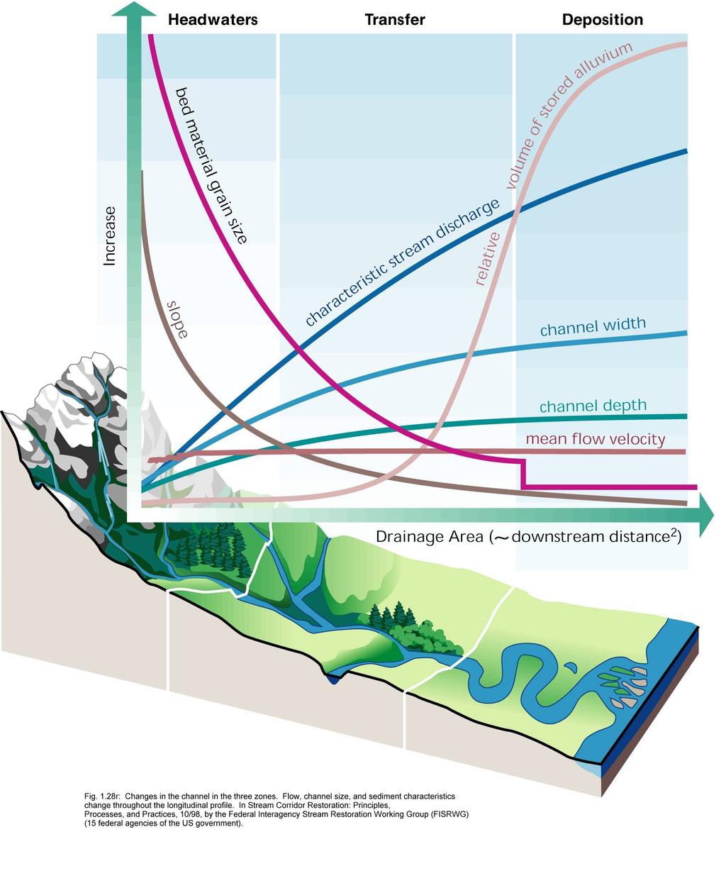
6 THE FLUVIAL SYSTEM Schumm (1977) provides an idealized sketch of a fluvial system. The parts are referred to as: Zone 1 - the upper portion of the system that is the watershed or drainage basin; this portion of the system functions as the sediment supply. Zone 2 -the middle portion of the system that is the river; this portion of the system functions as the sediment transfer zone. Zone 3 -the lower portion of the system may be a delta, wetland, lake, or reservoir; this portion of the system functions as the area of deposition.

7 Fluvial System

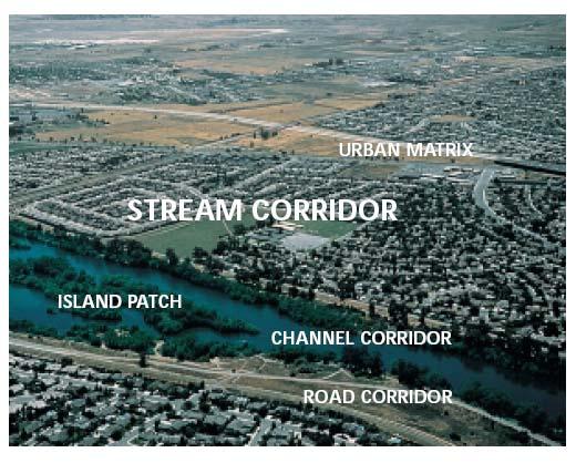
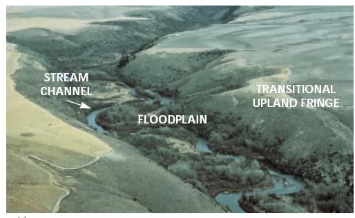
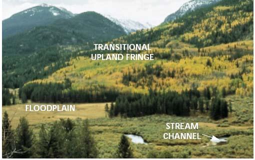
8 River Corridor
9
10


11 Natural Rivers Sungai Kg Jahang, Gopeng Sungai Ulu Paip, Kulim Sungai Sedim, Kulim Sungai Kulim, Kedah
 Before")
 Sediment was")

12 Rehabilitated Rivers in Jepun Nuki River (Kitakyushu City, Fukuoka Prefecture) Before construction ( October 1991 ) 23 months after construction (July 1995) Sediment was deposited on which vegetation grew, Creating a natural water space. Immediately after construction (August 1993)


 (a)")
 4 months")
13 Constructed River, Kampus Kejuruteraan USM Low flow (22 Mei 2003) High flow (19 Mei 2003) (a) 30th January 2003 (b) 4 months after Construction
14 Dr. Hans Albert Einstein (1972): If we change a river we usually do some good somewhere and good in quotation marks. That means we achieve some kind of a result that we are aiming at but sometimes forget that the same change which we are introducing may have widespread influences somewhere else. I think if, out of today's emphasis of the environment, anything results for us it is that it emphasizes the fact that we must look at a river or a drainage basin or whatever we are talking about as a big unit with many facets. We should not concentrate only on a little piece of that river unless we have some good reason to decide that we can do that.
15 The System is Dynamic Zone 1 is the sediment source that implies that erosion of sediment occurs. Zone 2 is the transfer zone that implies that as rainfall increases soil erosion from the watershed, some change must result in the stream to enable transfer of the increased sediment supply. Zone 3 is the zone of deposition and change must occur as sediment builds in this zone, perhaps the emergence of wetland habitat in a lake, then a change to a floodplain as a drier habitat evolves. The function of each zone implies that change is occurring in the system, and that the system is dynamic.
16 From an engineering viewpoint some of these changes may be very significant. For example, loss of 100 feet of stream bank may endanger a home or take valuable agricultural land. From a geomorphic viewpoint, these changes are expected in a dynamic system and change does not necessarily represent a departure from a natural equilibrium system. In planning stabilization measures, we must realize that we are forced to work in a dynamic system and we must be try to avoid disrupting the system while we are accomplishing our task.
17 Complexity Landscape changes are usually complex (Schumm and Parker, 1973). We are working in a system and we have defined a system as an arrangement of things to form a whole. Change to one portion of the system may result in complex changes throughout the system. When the fluvial system is subjected to an external influence such as channelization of part of a stream, we can expect change to occur throughout the system. Channelization usually increases stream velocity and this would allow the stream to transfer more sediment, resulting in erosion upstream and deposition downstream of the portion of the stream channelized.
18 Case 1 Some Yazoo Basin streams in north Mississippi that were channelized in the 1960s responded initially, but an equilibrium has not yet been reestablished as repeated waves of degradation, erosion, and aggradation have occurred.
19 Case 2 Development of the upper Rhine. In order to master flood damages and associated diseases, a Rhine correction was performed in the middle of the 20 th Century, by training the river into a straight river bed, thereby increasing the bed slope by about 30%. This in turn gave rise to an erosion process that even today has not yet come to an equilibrium state. Also the natural river with channels and bars was changed into a normalized cross section, thus reducing the diversity of habitats.
20 Thresholds Progressive change in one variable may eventually result in an abrupt change in the system. If a river erodes a few grains of soil from the toe of the river bank, no particular response will be noticed. If that continues with no deposition to balance the loss, the bank may eventually fail abruptly and dramatically due to undermining. The amount of flow impinging along a bank may vary considerably with no apparent effect on the stabilization; however, at some critical point the bank material will begin to move and disastrous consequences can result.
21 Channel systems have a measure of elasticity that enables change to be absorbed by a shift in equilibrium. The amount of change a system can absorb before that natural equilibrium is disturbed depends on the sensitivity of the system, and if the system is near a threshold condition, a minor change may result in a dramatic response.
22 Time Geomorphologists usually refer to three time scales in working with rivers: 1) geologic time,2) modern time, and 3) present time. Geologic time is usually expressed in thousands or millions of years, and in this time scale only major geologic activity would be significant. Formation of mountain ranges, changes in sea level, and climate change would be significant in this time scale. The modern time scale describes a period of tens of years to several hundred years, and has been called the graded time scale (Schumm and Lichty, 1965).
23 During this period a river may adjust to a balanced condition, adjusting to watershed water and sediment discharge. The present time is considered a shorter period, perhaps one year to ten years. No fixed rules govern these definitions. Design of a major project may require less than ten years, and numerous minor projects are designed and built within the limitations of present time. Project life often extends into graded time. From a geologist s, temporal point of view, engineers build major projects in an instant of time, and expect the projects to last for a significant period. In river related projects time is the enemy, time is our friend, and time is our teacher. We must learn all we can by adopting a historical perspective for each project that we undertake.
24 Scale A small stream will respond more rapidly than a large stream. Different processes may dominate instability in small streams than in large streams, for example, in large rivers bank failure may primarily be driven by geotechnical failure, whereas in a small stream, bank erosion may be dominated by grain-by-grain detachment. In addition, stabilization features that are effective on small streams may be ineffective on large streams.

25 LANDFORMS Landforms for a Meandering River (Collinson, 1978 after Allen, 1970)

26 Landforms and deposits of a meandering riverine flood plain

27 Classification of Valley Sediments
28 Floodplain A floodplain is the alluvial surface adjacent to a channel that is frequently inundated. Although much of the literature until the 1970s suggested that the mean annual flood was the bank full discharge, Williams (1978) clearly showed that out of thirty-five floodplains he studied in the U.S., the bank full discharge varied between the and 32-year recurrence interval. Only about a third of those streams had a bank full discharge between the 1- and 5-year recurrence interval discharge. Knowledge of alluvial landforms will allow a more informed determination of bank full than depending solely on the magnitude of the flood.

29 In stable alluvial streams, the high points on each bank represent the top of the bank full channel.


30 Bank full discharge This is the flow at which water begins to leave the channel and move onto the floodplain.

31 Determination of bank full stage rom a rating curve.
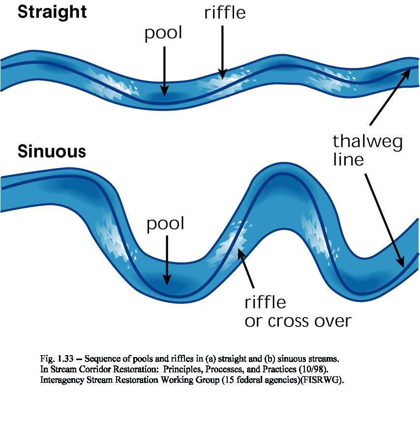
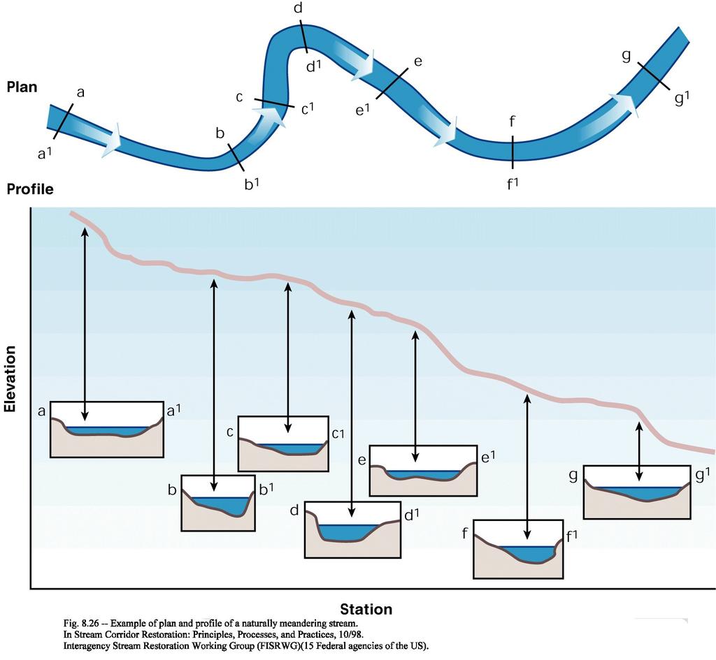
32 Bankfull Discharge Wolman and Leopold (1957) defined bankfull stage as the elevation of the active floodplain. Nixon (1959) defined the bankfull stage as the highest elevation of a river that can be contained within the channel without spilling water on the river floodplain or wash lands. Woodyer (1968) suggested bankfull stage as the elevation of the middle bench of rivers having several over-flow surfaces. Pickup and Warner (1976) defined bankfull stage as the elevation at which the width/depth ratio becomes a minimum.
33 River Mechanics
34 River mechanics is the subset of both fluvial geomorphology and open channel hydraulics which focuses on the form and structure of rivers. Specifically, it address the channel pattern, channel geometry (cross section shape), planform geometry, and the channel slope. Rivers and streams are dynamic and continuously change their position, shape, and other morphological characteristics with variations in discharge and with the passage of time. It is important not only to study the existing river but also the possible variations during the lifetime of the project, particularly in terms of effective treatment of bank erosion.
35 The characteristics of the river are determined by the water discharge, the quantity and character of sediment discharge, the composition of the bed and bank material of the channel, geologic controls, the variations of these parameters in time, and man's activities. To predict the behavior of a river in a natural state or as affected by man's activities, we must understand the characteristics of the river as well as the mechanics of formation.
36 River Equilibrium At equilibrium, slope and flow balance the size and quantity of sediment particles the stream moves.
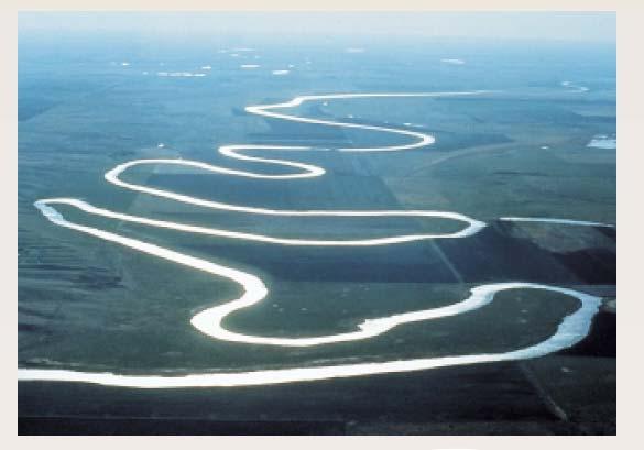
37 Channel Pattern Channel pattern describes the planform of a channel. The primary types of planform are meandering, braided, anastomosed, and straight. In many cases, a stream will change pattern within the length of the channel. The type pattern is dependent on slope, discharge, and sediment load. The most common channel pattern is the meandering stream. A meandering channel is one that is formed by a series of alternating changes in direction, or bends.
38 Relatively straight reaches of alluvial rivers rarely occur in nature. However, there are instances where a reach of river will maintain a nearly straight alignment for a long period of time. Even in these relatively straight reaches, the thalweg may still meander and alternate bars may be formed. Straight streams generally occur in relatively low energy environments. The braided pattern is characterized by a division of the river bed into multiple channels. Most braided streams are relatively high gradient and relatively coarse streams.
39 Typical Meandering River
40

41 Straight River

42 Typical Braided River
43 Pools and Crossings As the thalweg, or trace formed by the deepest portion of the channel, changes from side to side within the channel, the momentum of the flow affects the cross-sectional geometry of the stream. In bends, there is a concentration of flow due to centrifugal force. This causes the depth to increase at the outside of the bend, and this area is known as a pool. As the thalweg again changes sides below a bend, it crosses the centerline of the channel. This area is known as the riffle or crossing.
 Meandering")
44 Features Associated With (a) Straight and (b) Meandering Rivers
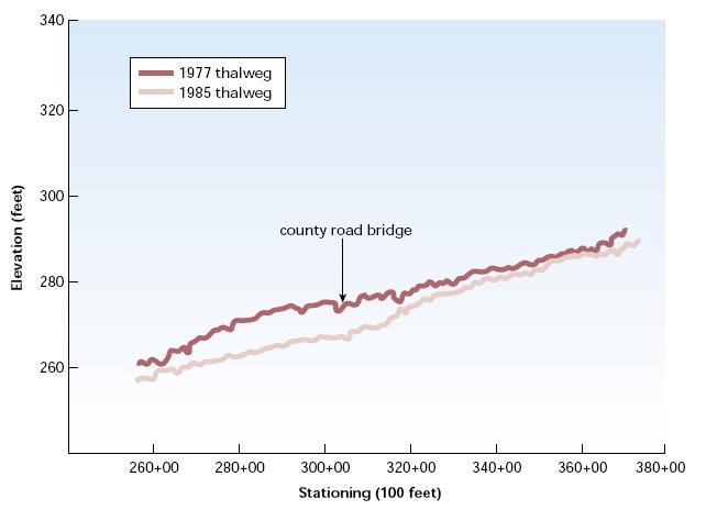
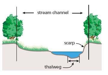
45
46
47 Cross Section Shape The cross section in a bend is deeper at the concave (outer bank) side with a nearly vertical bank, and has a shelving bank as formed by the point bar on the convex side. The cross section will be more trapezoidal or rectangular in a crossing.
48 Typical Plan and Cross Sectional View of Pools and Crossings
49
50
51 Channel Bars. Channel bars are depositional features that occur within the channel. The size and location of bars are related to the sediment transport capacity and local geometry of the reach. The enlargement of a bar generally results in caving of the opposite bank in order to maintain conveyance of the discharge. The primary types of bars are point bars, middle bars, and alternate bars.

52 Point Bar (Connected to banks)


53 Typical Middle Bar (Not connected to banks)

54 Typical Alternate Bar Pattern (Positioned successively down the river on opposite sides)
55 Planform Geometry. Definition Sketch for Channel Geometry (after Leopold et al., 1964)
56 Channel Slope The product of discharge (Q) and slope (s) is defined as stream power (= Q X S). Both discharge and slope are extremely significant parameters in the study and understanding of river behavior Slope is one of the best indicators of the ability of the river to do work. Rivers with steep slopes are generally much more active with respect to bank erosion, bar building, sediment movement, etc., than lower slope channels.
57 Slope can be defined in a number of ways. If sufficient data exists, the water surface slope maybe calculated using stage readings at gage locations along the channel. However, in many instances, particularly in small streams, gage information is non-existent. In these cases, the thalweg slope is generally calculated. Thalweg refers to the deepest point in a cross section. The thalweg slope not only provides a good expression of the energy of the stream, but also may aid in locating areas of scour and fill, geologic controls, and outcrops of non-erodible materials.
58 Relationships in Rivers
59
60 Leopold and Wolman s (1957) Relationship Between Channel Patterns, Channel Gradient, and Bank full Discharge
61 van den Berg (1995) Relationship Between Stream Power and Median Grain Size
62 Channel Classifications
63 Stable or Graded Channel A stream may then be classified as either stable or unstable. A channel that has adjusted dependent variables to accommodate the basin inputs (independent variables) is said to be stable. Mackin (1948) gave the following definition of a graded or stable stream: A graded stream is one in which, over a period of years, slope is delicately adjusted to provide, with available discharge and with prevailing channel characteristics, just the velocity required for the transportation of the load supplied from the drainage basin. The graded stream is a system in equilibrium.

64 River Equilibrium Lane relationship
65 A stream in dynamic equilibrium has adjusted its width, depth and slope such that the channel is neither aggrading nor degrading. However, change may be occurring in the stream bank, erosion may result, and bank stabilization may be necessary, even on the banks of a stream in dynamic equilibrium. In the context of stream rehabilitation, a stable stream is a graded stream in dynamic equilibrium.
66
67 Channel Classification Based on Pattern and Type of Sediment Load (after Schumm, 1981)

68 Classification of Alluvial Channels (after Schumm, 1977)
69 Summary of Delineative Criteria for Broad-level Classification (Rosgen, 1994)
 and Rosgen")
70 Channel Classification Combining Aspects of Schumm (1981) and Rosgen (1994)
71 Back to Nature

72 Restored channel of the Itach River, Japan (Meandering channel with a middle bar)

73 Nuki River, Japan 23 months after construction (July 1995). Sediment was deposited on which vegetation grew, creating a natural water space

74 Itabitsu River after improvement
Stream Geomorphology. Leslie A. Morrissey UVM July 25, 2012
 Stream Geomorphology Leslie A. Morrissey UVM July 25, 2012 What Functions do Healthy Streams Provide? Flood mitigation Water supply Water quality Sediment storage and transport Habitat Recreation Transportation
NATURAL RIVER. Karima Attia Nile Research Institute
 NATURAL RIVER CHARACTERISTICS Karima Attia Nile Research Institute NATURAL RIVER DEFINITION NATURAL RIVER DEFINITION Is natural stream of water that flows in channels with ih more or less defined banks.
OBJECTIVES. Fluvial Geomorphology? STREAM CLASSIFICATION & RIVER ASSESSMENT
 STREAM CLASSIFICATION & RIVER ASSESSMENT Greg Babbit Graduate Research Assistant Dept. Forestry, Wildlife & Fisheries Seneca Creek, Monongahela National Forest, West Virginia OBJECTIVES Introduce basic
Why Stabilizing the Stream As-Is is Not Enough
 Why Stabilizing the Stream As-Is is Not Enough Several examples of alternatives to the County s design approach have been suggested. A common theme of these proposals is a less comprehensive effort focusing
GLG362/GLG598 Geomorphology K. Whipple October, 2009 I. Characteristics of Alluvial Channels
 I. Characteristics of Alluvial Channels Self-formed morphology set by entrainment, transport, and deposition They move unconsolidated sedimentary materials present in the valley fill flood plain/bank flow
Stream Classification
 Stream Classification Why Classify Streams? Communication Tool Describe Existing Conditions & Trends Describe Restoration Goals Research Tool Morphologic Stream Classification Systems Schumm (1977) Alluvial
Riparian Assessment. Steps in the right direction... Drainage Basin/Watershed: Start by Thinking Big. Riparian Assessment vs.
 Riparian Assessment vs. Monitoring Riparian Assessment What is a healthy stream? Determine stream/riparian health Determine change or trend, especially in response to mgmt Classification = designation
Aquifer an underground zone or layer of sand, gravel, or porous rock that is saturated with water.
 Aggradation raising of the streambed by deposition that occurs when the energy of the water flowing through a stream reach is insufficient to transport sediment conveyed from upstream. Alluvium a general
GEOL 1121 Earth Processes and Environments
 GEOL 1121 Earth Processes and Environments Wondwosen Seyoum Department of Geology University of Georgia e-mail: seyoum@uga.edu G/G Bldg., Rm. No. 122 Seyoum, 2015 Chapter 6 Streams and Flooding Seyoum,
Step 5: Channel Bed and Planform Changes
 Step 5: Channel Bed and Planform Changes When disturbed, streams go through a series of adjustments to regain equilibrium with the flow and sediment supply of their watersheds. These adjustments often
NATURE OF RIVERS B-1. Channel Function... ALLUVIAL FEATURES. ... to successfully carry sediment and water from the watershed. ...dissipate energy.
 1 2 Function... Sevier River... to successfully carry sediment and water from the watershed....dissipate energy. 3 ALLUVIAL FEATURES 4 CHANNEL DIMENSION The purpose of a stream is to carry water and sediment
3/3/2013. The hydro cycle water returns from the sea. All "toilet to tap." Introduction to Environmental Geology, 5e
 Introduction to Environmental Geology, 5e Running Water: summary in haiku form Edward A. Keller Chapter 9 Rivers and Flooding Lecture Presentation prepared by X. Mara Chen, Salisbury University The hydro
Why Geomorphology for Fish Passage
 Channel Morphology - Stream Crossing Interactions An Overview Michael Love Michael Love & Associates mlove@h2odesigns.com (707) 476-8938 Why Geomorphology for Fish Passage 1. Understand the Scale of the
Do you think sediment transport is a concern?
 STREAM RESTORATION FRAMEWORK AND SEDIMENT TRANSPORT BASICS Pete Klingeman 1 What is Your Restoration Project Like? k? Do you think sediment transport is a concern? East Fork Lewis River, WA Tidal creek,
ADDRESSING GEOMORPHIC AND HYDRAULIC CONTROLS IN OFF-CHANNEL HABITAT DESIGN
 ADDRESSING GEOMORPHIC AND HYDRAULIC CONTROLS IN OFF-CHANNEL HABITAT DESIGN Conor Shea - Hydrologist U.S. Fish and Wildlife Service Conservation Partnerships Program Arcata, CA Learning Objectives Examine
Business. Meteorologic monitoring. Field trip? Reader. Other?
 Business Meteorologic monitoring Field trip? Reader Other? Classification Streams Characterization Discharge measurements Why classify stream channels? Why Classify Stream Channels? Provides a common language
May 7, Roger Leventhal, P.E. Marin County Public Works Laurel Collins Watershed Sciences
 May 7, 2013 Roger Leventhal, P.E. Marin County Public Works Laurel Collins Watershed Sciences Background Funded in 2009 under EPA 2100 Grant for $30k and managed by SFEP Project Goals: Update original
Overview of fluvial and geotechnical processes for TMDL assessment
 Overview of fluvial and geotechnical processes for TMDL assessment Christian F Lenhart, Assistant Prof, MSU Research Assoc., U of M Biosystems Engineering Fluvial processes in a glaciated landscape Martin
Annotated Bibliography of River Avulsions Pat Dryer Geography 364 5/14/2007
 Annotated Bibliography of River Avulsions Pat Dryer Geography 364 5/14/2007 1 Table of Contents Introduction 2 Annotations I. River avulsions and their deposits 2 II. Channel avulsion on alluvial fans
Streams. Stream Water Flow
 CHAPTER 14 OUTLINE Streams: Transport to the Oceans Does not contain complete lecture notes. To be used to help organize lecture notes and home/test studies. Streams Streams are the major geological agents
PolyMet NorthMet Project
 RS 26 Draft-01 December 8, 2005 RS26 Partridge River Level 1 Rosgen Geomorphic Survey Rosgen Classification Partridge River from Headwaters to Colby Lake Prepared for PolyMet NorthMet Project December
Vermont Stream Geomorphic Assessment. Appendix E. River Corridor Delineation Process. VT Agency of Natural Resources. April, E0 - April, 2004
 Vermont Stream Geomorphic Assessment Appendix E River Corridor Delineation Process Vermont Agency of Natural Resources - E0 - River Corridor Delineation Process Purpose A stream and river corridor delineation
Rivers T. Perron
 1 Rivers T. Perron 12.001 After our discussions of large-scale topography, how we represent topography in maps, and how topography interacts with geologic structures, you should be frothing at the mouth
Working with Natural Stream Systems
 Working with Natural Stream Systems Graydon Dutcher Delaware County Soil & Water Conservation District Stream Corridor Management Program Tropical Storm Sandy October 29,2012 What is a Watershed?
Dolores River Watershed Study
 CHAPTER 4: RIVER AND FLOODPLAIN ISSUES The Dolores River falls into a category of streams in Colorado that share some unique characteristics. Like some other mountain streams in the state, it has a steep
Running Water Earth - Chapter 16 Stan Hatfield Southwestern Illinois College
 Running Water Earth - Chapter 16 Stan Hatfield Southwestern Illinois College Hydrologic Cycle The hydrologic cycle is a summary of the circulation of Earth s water supply. Processes involved in the hydrologic
Surface Water and Stream Development
 Surface Water and Stream Development Surface Water The moment a raindrop falls to earth it begins its return to the sea. Once water reaches Earth s surface it may evaporate back into the atmosphere, soak
SCOPE OF PRESENTATION STREAM DYNAMICS, CHANNEL RESTORATION PLANS, & SEDIMENT TRANSPORT ANALYSES IN RELATION TO RESTORATION PLANS
 DESIGN METHODS B: SEDIMENT TRANSPORT PROCESSES FOR STREAM RESTORATION DESIGN PETER KLINGEMAN OREGON STATE UNIVERSITY CIVIL ENGINEERING DEPT., CORVALLIS 2 ND ANNUAL NORTHWEST STREAM RESTORATION DESIGN SYMPOSIUM
CR AAO Bridge. Dead River Flood & Natural Channel Design. Mitch Koetje Water Resources Division UP District
 CR AAO Bridge Dead River Flood & Natural Channel Design Mitch Koetje Water Resources Division UP District Old County Road AAO Bridge Map courtesy of Marquette County Silver Lake Basin McClure Basin
A GEOMORPHOLOGICAL APPROACH TO RESTORATION OF INCISED RIVERS. David L. Rosgen 1
 Proceedings of the Conference on Management of Landscapes Disturbed by Channel Incision, 1997 S.S.Y. Wang, E.J. Langendoen and F.D. Shields, Jr. (eds.) ISBN 0-937099-05-8 A GEOMORPHOLOGICAL APPROACH TO
MEANDER MIGRATION MODEL ASSESSMENT FOR THE JANUARY 2005 STORM, WHITMAN PROPERTY, SAN ANTONIO CREEK, VENTURA COUNTY, CALIFORNIA
 MEANDER MIGRATION MODEL ASSESSMENT FOR THE JANUARY 2005 STORM, WHITMAN PROPERTY, SAN ANTONIO CREEK, VENTURA COUNTY, CALIFORNIA Prepared by Eric Larsen, Ph.D. Mark Rains, Ph.D. October 2006 INTRODUCTION
Dams, sediment, and channel changes and why you should care
 Dams, sediment, and channel changes and why you should care Gordon E. Grant USDA Forest Service PNW Research Station Corvallis, Oregon Dam effects on river regimes FLOW (Q) SEDIMENT (Qs) TEMP CHEMISTRY
Tom Ballestero University of New Hampshire. 1 May 2013
 Tom Ballestero University of New Hampshire 1 May 2013 1 Hydrology 2 Basic Hydrology Low flows most common Flows that fill the stream to the banks and higher are much less common Filling the stream to the
WATER ON AND UNDER GROUND. Objectives. The Hydrologic Cycle
 WATER ON AND UNDER GROUND Objectives Define and describe the hydrologic cycle. Identify the basic characteristics of streams. Define drainage basin. Describe how floods occur and what factors may make
CHANNEL GEOMORPHIC RESPONSES TO DISTURBANCES ASSESSED USING STREAMGAGE INFORMATION
 CHANNEL GEOMORPHIC RESPONSES TO DISTURBANCES ASSESSED USING STREAMGAGE INFORMATION Kyle E. Juracek, Research Hydrologist, U.S. Geological Survey, Lawrence, KS, kjuracek@usgs.gov; Mark W. Bowen, Ph.D. candidate,
mountain rivers fixed channel boundaries (bedrock banks and bed) high transport capacity low storage input output
 high transport capacity low storage input output") mountain rivers fixed channel boundaries (bedrock banks and bed) high transport capacity low storage input output strong interaction between streams & hillslopes Sediment Budgets for Mountain Rivers Little
mountain rivers fixed channel boundaries (bedrock banks and bed) high transport capacity low storage input output strong interaction between streams & hillslopes Sediment Budgets for Mountain Rivers Little
Wetland & Floodplain Functional Assessments and Mapping To Protect and Restore Riverine Systems in Vermont. Mike Kline and Laura Lapierre Vermont DEC
 Wetland & Floodplain Functional Assessments and Mapping To Protect and Restore Riverine Systems in Vermont Mike Kline and Laura Lapierre Vermont DEC NWI+ Hydro-Geomorphic Characterization of Wetlands and
Ways To Identify Background Verses Accelerated Erosion
 Ways To Identify Background Verses Accelerated Erosion Establish Background Condition From Old Ground Photos, Aerial Photos, and Maps Compare Rate Over Time At the Same Location, or for Reaches Channel
Technical Supplement 3E. Rosgen Stream Classification Technique Supplemental Materials. (210 VI NEH, August 2007)
") Technical Supplement 3E (210 VI NEH, August 2007) Issued August 2007 Cover photo: The Rosgen stream classification system uses morphometric data to characterize streams. Advisory Note Techniques and approaches
Technical Supplement 3E (210 VI NEH, August 2007) Issued August 2007 Cover photo: The Rosgen stream classification system uses morphometric data to characterize streams. Advisory Note Techniques and approaches
River Restoration and Rehabilitation. Pierre Y. Julien
 River Restoration and Rehabilitation Pierre Y. Julien Department of Civil and Environmental Engineering Colorado State University Fort Collins, Colorado River Mechanics and Sediment Transport Lima Peru
Fluvial Systems Lab Environmental Geology Lab Dr. Johnson
 Fluvial Systems Lab Environmental Geology Lab Dr. Johnson *Introductory sections of this lab were adapted from Pidwirny, M. (2006). "Streamflow and Fluvial Processes". Fundamentals of Physical Geography,
MATHEMATICAL MODELING OF FLUVIAL SEDIMENT DELIVERY, NEKA RIVER, IRAN. S.E. Kermani H. Golmaee M.Z. Ahmadi
 JOURNAL OF ENVIRONMENTAL HYDROLOGY The Electronic Journal of the International Association for Environmental Hydrology On the World Wide Web at http://www.hydroweb.com VOLUME 16 2008 MATHEMATICAL MODELING
River floodplain regime and stratigraphy. Drs. Nanette C. Kingma.
 River floodplain regime and stratigraphy. Drs. Nanette C. Kingma. Formation of floodplain. Formation of floodplains: lateral channel migration in channel deposition suspended-load fall out during higher
Watershed Assessment of River Stability and Sediment Supply: Advancing the Science of Watershed Analysis
 Watershed Assessment of River Stability and Sediment Supply: Advancing the Science of Watershed Analysis 2009 MWEA Annual Conference Rob Myllyoja, CET rmyllyoja@hrc-engr.com Watershed Assessment of River
Kaskaskia Morphology Study Headwaters to Lake Shelbyville
 Kaskaskia Morphology Study Headwaters to Lake Shelbyville KWA Mini Summit 5 March 2012 1 Kaskaskia Morphology Study Headwaters to Lake Shelbyville Conducted by U.S. Army Corps of Engineers, St. Louis District
Landscape Development
 Landscape Development Slopes Dominate Natural Landscapes Created by the interplay of tectonic and igneous activity and gradation Deformation and uplift Volcanic activity Agents of gradation Mass wasting
LEVEE DESIGN FOR FLOOD PROTECTION ON ALLUVIAL FANS
 LEVEE DESIGN FOR FLOOD PROTECTION ON ALLUVIAL FANS BRUCE M. PHILLIPS 1 ABSTRACT The dynamic nature of alluvial fans in arid environments offers numerous floodplain management challenges primarily due to
Diagnostic Geomorphic Methods for Understanding Future Behavior of Lake Superior Streams What Have We Learned in Two Decades?
 Diagnostic Geomorphic Methods for Understanding Future Behavior of Lake Superior Streams What Have We Learned in Two Decades? Faith Fitzpatrick USGS WI Water Science Center, Middleton, WI fafitzpa@usgs.gov
Geomorphology Geology 450/750 Spring Fluvial Processes Project Analysis of Redwood Creek Field Data Due Wednesday, May 26
 Geomorphology Geology 450/750 Spring 2004 Fluvial Processes Project Analysis of Redwood Creek Field Data Due Wednesday, May 26 This exercise is intended to give you experience using field data you collected
Channel Pattern. Channel Pattern, Meanders, and Confluences. Description of Channel Pattern. Bridge (2003)
") Channel Pattern Channel Pattern, Meanders, and Confluences Outline Description of channel pattern Alternate bars Channel pattern continua and evolution Controls of channel pattern Description of Channel
Channel Pattern Channel Pattern, Meanders, and Confluences Outline Description of channel pattern Alternate bars Channel pattern continua and evolution Controls of channel pattern Description of Channel
Summary. Streams and Drainage Systems
 Streams and Drainage Systems Summary Streams are part of the hydrologic cycle and the chief means by which water returns from the land to the sea. They help shape the Earth s surface and transport sediment
CASE STUDIES. Introduction
 Introduction The City of Winston-Salem faces the challenge of maintaining public infrastructure (e.g., water and sewer lines, storm drains, roads, culverts and bridges) while minimizing the potential impacts
Fresh Water: Streams, Lakes Groundwater & Wetlands
 Fresh Water:, Lakes Groundwater & Wetlands Oct 27 Glaciers and Ice Ages Chp 13 Nov 3 Deserts and Wind and EXAM #3 Slope hydrologic cycle P = precip I = precip intercepted by veg ET = evapotranspiration
Important Copyright Information
 Important Copyright Information The following content is provided for educational purposes by the workshop presenter. This content may or may not have been peer reviewed. Information, opinions and recommendations
Four Mile Run Levee Corridor Stream Restoration
 Four Mile Run Levee Corridor Stream Restoration 30% Design Summary U.S. Army Corps of Engineers, Baltimore District Presentation Outline Four Mile Run 1.) Historic Perspective 2.) Existing Conditions 3.)
Forest Service AOP Meeting Objectives of Stream Simulation: Examples and Talking Points
 Forest Service AOP Meeting Objectives of Stream Simulation: Examples and Talking Points Traci Sylte, P.E. Hydrology/Fluvial Geomorphology Lolo National Forest Is It True? Are Road Crossings a Dam with
(3) Sediment Movement Classes of sediment transported
 Sediment Movement Classes of sediment transported") (3) Sediment Movement Classes of sediment transported Dissolved load Suspended (and wash load ) Important for scouring algae Bedload (5-10% total load Moves along bed during floods Source of crushing for
(3) Sediment Movement Classes of sediment transported Dissolved load Suspended (and wash load ) Important for scouring algae Bedload (5-10% total load Moves along bed during floods Source of crushing for
27. Running Water I (p ; )
") 27. Running Water I (p. 424-436; 440-444) Hydrosphere How much of the Earth s surface is covered by water? Earth's water is collectively called the and is stored in a number of so-called as follows: 1.
27. Running Water I (p. 424-436; 440-444) Hydrosphere How much of the Earth s surface is covered by water? Earth's water is collectively called the and is stored in a number of so-called as follows: 1.
Assessment. Assessment
 2001 SPRINGBROOK CREEK RESTORATION - THREE YEAR POST-CONSTRUCTION REVIEW - Presented by Bruce Henderson and Andy Harris 2005 River Restoration Northwest Symposium Skamania Lodge, Washington www.hendersonlandservices.com
LAB-SCALE INVESTIGATION ONBAR FORMATION COORDINATES IN RIVER BASED ON FLOW AND SEDIMENT
 LAB-SCALE INVESTIGATION ONBAR FORMATION COORDINATES IN RIVER BASED ON FLOW AND SEDIMENT Mat Salleh M. Z., Ariffin J., Mohd-Noor M. F. and Yusof N. A. U. Faculty of Civil Engineering, University Technology
Erosion Surface Water. moving, transporting, and depositing sediment.
 + Erosion Surface Water moving, transporting, and depositing sediment. + Surface Water 2 Water from rainfall can hit Earth s surface and do a number of things: Slowly soak into the ground: Infiltration
Channel-Forming Discharge
 Channel-Forming Discharge by R. R. Copeland, D. S. Biedenharn, and J. C. Fischenich PURPOSE: The purpose of this Technical Note is to provide guidance and cautions to be used in approximating channel-forming
!"#$%&&'()*+#$%(,-./0*)%(!
*+#$%(,-./0*)%(!") 8:30 Sign in Hoosic River Revival Coalition!"#$%&&'()*+#$%(,-./0*)%(! 12-#30+4/#"5-(60 9:00 Welcome and Introductions 9:15 Goals for Today s Program: A Description of the Planning Process 9:30 First Session:
8:30 Sign in Hoosic River Revival Coalition!"#$%&&'()*+#$%(,-./0*)%(! 12-#30+4/#"5-(60 9:00 Welcome and Introductions 9:15 Goals for Today s Program: A Description of the Planning Process 9:30 First Session:
Rapid Geomorphic Assessments: RGA s
 Establishing Current Reference Conditions Rates and concentrations of suspended-sediment transport vary over time and space due to factors such as precipitation characteristics and discharge, geology,
The Equilibrium Channel & Channel Change. Peter Wilcock 3 August 2016
 The Equilibrium Channel & Channel Change Peter Wilcock 3 August 2016 1 The search for common empirical attributes of streams Luna B. Leopold M. Gordon ( Reds ) Wolman Watts Branch, MD A meandering stream
Rosgen Classification Unnamed Creek South of Dunka Road
 Rosgen Classification Unnamed Creek South of Dunka Road Prepared for Poly Met Mining Inc. September 2013 Rosgen Classification Unnamed Creek South of Dunka Road Prepared for Poly Met Mining Inc. September
ES 105 Surface Processes I. Hydrologic cycle A. Distribution % in oceans 2. >3% surface water a. +99% surface water in glaciers b.
 ES 105 Surface Processes I. Hydrologic cycle A. Distribution 1. +97% in oceans 2. >3% surface water a. +99% surface water in glaciers b. >1/3% liquid, fresh water in streams and lakes~1/10,000 of water
Floods Lecture #21 20
 Floods 20 Lecture #21 What Is a Flood? Def: high discharge event along a river! Due to heavy rain or snow-melt During a flood, a river:! Erodes channel o Deeper & wider! Overflows channel o Deposits sediment
Upper Truckee River Restoration Lake Tahoe, California Presented by Brendan Belby Sacramento, California
 Upper Truckee River Restoration Lake Tahoe, California Presented by Brendan Belby Sacramento, California Mike Rudd (Project Manager), Charley Miller & Chad Krofta Declines in Tahoe s Water Clarity The
Appendix E Rosgen Classification
 Appendix E Stream Type s Using the morphometric parameters described above, stream reaches are classified into 7 major stream types (Aa+ through G) based on s (1996) criteria. The relevant stream classifications
Solutions to Flooding on Pescadero Creek Road
 Hydrology Hydraulics Geomorphology Design Field Services Photo courtesy Half Moon Bay Review Solutions to Flooding on Pescadero Creek Road Prepared for: San Mateo County Resource Conservation District
(3) Sediment Movement Classes of sediment transported
 Sediment Movement Classes of sediment transported") 9/17/15 (3) Sediment Movement Classes of sediment transported Dissolved load Suspended load Important for scouring algae Bedload (5-10% total load) Moves along bed during floods Source of crushing for
9/17/15 (3) Sediment Movement Classes of sediment transported Dissolved load Suspended load Important for scouring algae Bedload (5-10% total load) Moves along bed during floods Source of crushing for
Streams. Water. Hydrologic Cycle. Geol 104: Streams
 Streams Why study streams? Running water is the most important geologic agent in erosion, transportation and deposition of sediments. Water The unique physical and chemical properties of water make it
Avoiding Geohazards in the Mid-Atlantic Highlands by Using Natural Stream Principles
 Avoiding Geohazards in the Mid-Atlantic Highlands by Using Natural Stream Principles J. Steven Kite, WVU Neal Carte, WVDOT Will Harman, Michael Baker Corp. Donald D. Gray, WVU Photo: W. Gillespie North
Field Methods to Determine/ Verify Bankfull Elevation, XS Area & Discharge
 Module # 6 Field Methods to Determine/ Verify Bankfull Elevation, XS Area & Discharge Iowa s River Restoration Toolbox Level 1 / Base Training Overview of Basic Field Data Collection Site Map Cross Sections
Table 6.1 Progress in the identification of equilibrium states in geomorphology
 6 The concept of equilibrium emerged in geomorphology once ideas of catastrophism had been succeeded by the understanding that gradual land-forming processes were responsible for the shape of the Earth
Discharge. Discharge (Streamflow) is: Q = Velocity (L T -1 ) x Area (L 2 ) Units: L 3 T -1 e.g., m 3 s -1. Velocity. Area
 is: Q = Velocity (L T -1 ) x Area (L 2 ) Units: L 3 T -1 e.g., m 3 s -1. Velocity. Area") Discharge Discharge (Streamflow) is: Q = Velocity (L T -1 ) x Area (L 2 ) Units: L 3 T -1 e.g., m 3 s -1 Velocity Area Where is the average velocity?? 3 Source: Brooks et al., Hydrology and the Management
Discharge Discharge (Streamflow) is: Q = Velocity (L T -1 ) x Area (L 2 ) Units: L 3 T -1 e.g., m 3 s -1 Velocity Area Where is the average velocity?? 3 Source: Brooks et al., Hydrology and the Management
How Do Human Impacts and Geomorphological Responses Vary with Spatial Scale in the Streams and Rivers of the Illinois Basin?
 How Do Human Impacts and Geomorphological Responses Vary with Spatial Scale in the Streams and Rivers of the Illinois Basin? Bruce Rhoads Department of Geography University of Illinois at Urbana-Champaign
GENERAL SUMMARY BIG WOOD RIVER GEOMORPHIC ASSESSMENT BLAINE COUNTY, IDAHO
 GENERAL SUMMARY BIG WOOD RIVER GEOMORPHIC ASSESSMENT BLAINE COUNTY, IDAHO Prepared For Trout Unlimited 300 North Main Street, Hailey, Idaho, 83333 Prepared By P. O. Box 8578, 140 E. Broadway, Suite 23,
Technical Memorandum. To: From: Copies: Date: 10/19/2017. Subject: Project No.: Greg Laird, Courtney Moore. Kevin Pilgrim and Travis Stroth
 Technical Memorandum To: From: Greg Laird, Courtney Moore Kevin Pilgrim and Travis Stroth 5777 Central Avenue Suite 228 Boulder, CO 80301 www.otak.com Copies: [Electronic submittal] Date: 10/19/2017 Subject:
Degradation Concerns related to Bridge Structures in Alberta
 Degradation Concerns related to Bridge Structures in Alberta Introduction There has been recent discussion regarding the identification and assessment of stream degradation in terms of how it relates to
New Approaches to Restoring NH s Rivers Natural Channel Design and Dam Removal
 NHACC Annual Meeting 2012 New Approaches to Restoring NH s Rivers Natural Channel Design and Dam Removal Peter J. Walker CROOKED STREAMS are a menace to life and crops in the areas bordering on their banks.
Fish Passage at Road Crossings
 Fish Passage at Road Crossings 1 Crossing Design Workshop Outline 1:00 to 2:00 Intro, Design Overview, Channel Width 2:00 to 2:15 Break 2:15 to 3:15 No-Slope, Stream Simulation Design 3:15 to 3:30 Break
Earth Science Chapter 6 Section 2 Review
 Name: Class: Date: Earth Science Chapter 6 Section Review Multiple Choice Identify the choice that best completes the statement or answers the question. 1. Most streams carry the largest part of their
Lab 13: Fluvial Processes and Landforms
 Name: Lab 13: Fluvial Processes and Landforms Geomorphology is the study of Earth s surface and of the processes acting to shape it. Streams, for example, are significant continental land-shaping agents.
GEOL 652. Poudre River Fieldtrip
 GEOL 652. Poudre River Fieldtrip One of the more difficult variables to measure and/or estimate when studying flow in natural channels is that of roughness. Roughness, usually approximated with Manning
Final Exam. Running Water Erosion and Deposition. Willamette Discharge. Running Water
 Final Exam Running Water Erosion and Deposition Earth Science Chapter 5 Pages 120-135 Scheduled for 8 AM, March 21, 2006 Bring A scantron form A calculator Your 3 x 5 paper card of formulas Review questions
What is weathering and how does it change Earth s surface? Answer the question using
 7 th Grade Lesson What is weathering and how does it change Earth s surface? Answer the question using the sentence frame. You have 4 minutes. Weathering is. This changes the Earth s surface because. 1
Environmental Geology Chapter 9 Rivers and Flooding
 Environmental Geology Chapter 9 Rivers and Flooding Flooding in Pakistan 2010-1600 killed/20000 affected The hydrologic cycle is powered by the Sun The cycle includes evaporation, precipitation, infiltration,
Application of Fluvial Geomorphologic Techniques At Abandoned Mine Sites 1. David A. Greenfield 2 Dennis M. Palladino 3
 Application of Fluvial Geomorphologic Techniques At Abandoned Mine Sites 1 David A. Greenfield 2 Dennis M. Palladino 3 ABSTRACT Watersheds that have been severely impacted by mining can no longer transport
Each basin is surrounded & defined by a drainage divide (high point from which water flows away) Channel initiation
 Channel initiation") DRAINAGE BASINS A drainage basin or watershed is defined from a downstream point, working upstream, to include all of the hillslope & channel areas which drain to that point Each basin is surrounded &
DRAINAGE BASINS A drainage basin or watershed is defined from a downstream point, working upstream, to include all of the hillslope & channel areas which drain to that point Each basin is surrounded &
The last three sections of the main body of this report consist of:
 Threatened and Endangered Species Geological Hazards Floodplains Cultural Resources Hazardous Materials A Cost Analysis section that provides comparative conceptual-level costs follows the Environmental
Appendix K.2: Sediment Management Excerpt from South Orange County Hydromodification Management Plan
 Appendix K.2: Sediment Management Excerpt from South Orange County Hydromodification Management Plan 4 Sediment Supply Management Requirements Permit Order R9-2013-0001 as amended by Order No. R9-2015-0001Section
Vermont Stream Geomorphic Assessment. Appendix J. Vermont Regional Hydraulic Geometry Curves
 Vermont Stream Geomorphic Assessment Appendix J Vermont Regional Hydraulic Geometry Curves River Management Program Vermont Water Quality Division November, 2001 Natural Resources - J0 - VT Agency of Background
STREAM SYSTEMS and FLOODS
 STREAM SYSTEMS and FLOODS The Hydrologic Cycle Precipitation Evaporation Infiltration Runoff Transpiration Earth s Water and the Hydrologic Cycle The Hydrologic Cycle The Hydrologic Cycle Oceans not filling
Precipitation Evaporation Infiltration Earth s Water and the Hydrologic Cycle. Runoff Transpiration
 STREAM SYSTEMS and FLOODS The Hydrologic Cycle Precipitation Evaporation Infiltration Earth s Water and the Hydrologic Cycle Runoff Transpiration The Hydrologic Cycle The Hydrologic Cycle Oceans not filling
GY 111 Lecture Note Series Sedimentary Environments 2: Rivers and Deltas
 GY 111 Lecture Notes D. Haywick (2008-09) 1 GY 111 Lecture Note Series Sedimentary Environments 2: Rivers and Deltas Lecture Goals A) Rivers and Deltas (types) B) Water Flow and sedimentation in river/deltas
STUDY GUIDE FOR CONTENT MASTERY. Surface Water Movement
 Surface Water SECTION 9.1 Surface Water Movement In your textbook, read about surface water and the way in which it moves sediment. Complete each statement. 1. An excessive amount of water flowing downslope
Fluvial Geomorphic Guidelines
 Fluvial Geomorphic Guidelines FACT SHEET I: GEOMORPHOLOGICAL HAZARDS CONFINED AND UNCONFINED WATERCOURSES Channel migration and erosion can create substantial risk to inappropriately located infrastructure
Sediment Transport Analysis for Stream Restoration Design: The Good, the Bad, and the Ugly.
 Sediment Transport Analysis for Stream Restoration Design: The Good, the Bad, and the Ugly. Brett Jordan Phd, PE HydroGeo Designs LLC. Land and Water Services Inc. THE GOOD THE BAD THE UGLY THE GOOD THE