Perspectives on river restoration science, geomorphic processes, and channel stability
|
|
|
- Hilary Bennett
- 5 years ago
- Views:
Transcription

1 Perspectives on river restoration science, geomorphic processes, and channel stability Stream Restoration Forum: Science and Regulatory Connections Andrew C. Wilcox Department of Geosciences University of Montana Missoula, MT

2 Overview Reconfiguration vs reconnection restoration Channel stability Vertical vs lateral stability Flow and sediment regimes Structures as means to manipulate channel stability Modelling approaches to evaluating stability Other perspectives on river restoration
3 Reconfiguration restoration Reach-scale Create stability Increase habitat heterogeneity Ecological benefits?
4 Form-based restoration: extreme cases no longer the norm


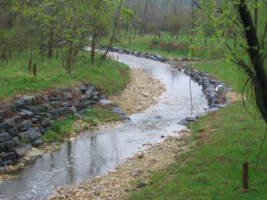
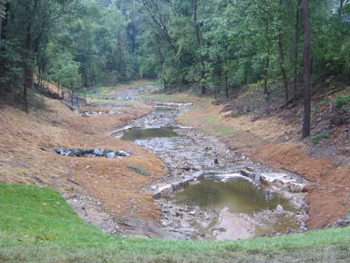
5 Common approaches to creating stability: Bank structures to prevent lateral movement Boulders or large logs in bed to prevent vertical movement Plantings along banks and floodplain to provide cohesion Conceptual model: Prevent channel movement during ~1 st decade to allow riparian vegetation establishment Subsequently bank stabilizing materials will decompose, allowing dynamic channel Wildland Hydrology, 2008: Kootenai River Conceptual Design


6 Reconnection restoration: Floodplain connectivity Mareit River, Italy Sacramento River, CA Provo River, UT Kissimmee River, FL Kootenai River, ID
7 CB Trust Restoration Research Theme Stability of stream restoration practices and elements of practices Research is needed to better understand why and when stream restoration practices fail in order to reduce failures and increase successes. We recognize that there is no standard definition of failure, definition of stability, or agreed upon tolerance for movement of stream materials within or from a project.
8 Stream stability is morphologically defined as the ability of the stream to maintain, over time, its dimension, pattern, and profile in such a manner that it is neither aggrading or degrading and is able to effectively transport the flows and sediment delivered to it by its watershed. Morphologic stability permits the full expression of natural stream characteristics.
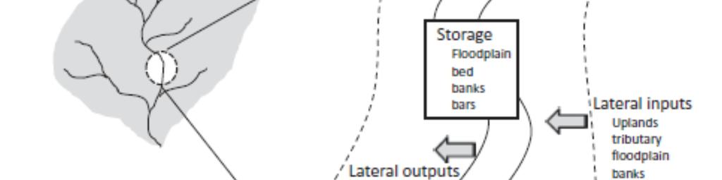
9 Sediment Balance in Channel Restoration Design The core questions: What is the supply of water and sediment? What do you want to do with it? More precisely: 1. What is the water discharge Q(t) & sediment supply rate Q s (t) and grain size D(t) delivered to the upstream end of the design reach? 2. How will the available flow move the supplied sediment through the design reach? Sediment supply Transport capacity (P. Wilcock)

10 Wohl et al. 2015, BioScience
 If I>O, then S Bed aggrades (z ) If I<O, then S Bed scours (z ) Sediment transport channel change Quantifying")
11 Conservation of sediment mass I O= S Input (of sediment) Output (of sediment)= Change in (sediment) storage Sediment balance: If I=O, then S=0 Bed elevation (z) does not change z ( 1 λp ) t q s = - x λ p : bed porosity z: bed elevation q s : sediment transport rate (per unit width) If I>O, then S Bed aggrades (z ) If I<O, then S Bed scours (z ) Sediment transport channel change Quantifying sediment balance provides a basis for predicting channel behavior
 Church, 2006,")
12 Lateral stability Lateral stability harder to predict than vertical stability Driving & resisting forces more complex Local & non fluvial influences Biotic & abiotic influences Bank erosion (high local τ) Church, 2006, AREPS

13 The core questions: What is the supply of water and sediment? What do you want to do with it? Often, instead of answering the core questions, we: Replace them with assumptions: Channels are unstable Sediment inputs are from bank erosion There is a predictable dominant discharge Use structures as a substitute Grade control Bank protection The core questions are difficult to answer But we cannot wish them away Ignoring them is basis for project failure Large uncertainty unpredictable Uncertainty must be incorporated in channel design Smith and Wilcock, 2015, Geomorphology (P. Wilcock)
 quantitative performance measure: sediment balance,")


14 Restoration success vs failure Objectives A necessary (but not sufficient) quantitative performance measure: sediment balance, averaged over all flows Perception that restoration synonymous with stability In contrast to ecological restoration What is failure? In what conditions can we Build restoration projects without reliance on structures? Relax the need to quantify sediment balance? Communication critical
 Cross-site comparison of specific type of structure?")
 function and remain stable? Cross-site comparison of specific approach?")

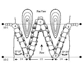
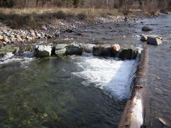
15 CB Trust Restoration Research What are the flow conditions Local hydraulics (metrics: velocity, shear stress)? Flood recurrence interval? How to generalize? under which different in-stream channel structures (e.g., vanes, step pools, constructed riffles, large woody debris) Cross-site comparison of specific type of structure? Pooled study of all types of structures? or approaches (e.g., RSC, NCD, stream valley restoration/legacy sediment removal) function and remain stable? Cross-site comparison of specific approach? Pooled study of all approaches? What are the energy tolerances beyond which the structures or approaches begin to fail? How to define failure? How to quantifying energy tolerance? LITTLE IS KNOWN ABOUT ANSWERS TO THESE QUESTIONS! Rock vane J-hook Bendway weir [Craig Hill, after Rosgen, 2006, NRCS 2007]


16 Damage States Framework Damage scores assigned for Infrastructure protection Structural integrity Bank stability and migration Damage scores from none to complete Flood hazard Vertical stability Wood & sediment transport Bank vegetation Moderately damaged J-hook Miller and Kochel 2010, Env. Earth Sci Jones and Johnson, 2015, JAWRA
17 CB Trust Restoration Research How well can various modelling approaches predict the structural success or failure for the various stream restoration techniques and structures? What variables must be included in the models to make accurate predictions for stream restoration success or failure at the site? Possible Elements of the Experimental Design: Compare 1D and 2D model predictions with real life success or failure (i.e., degree of sediment movement, degree of loss of materials), including enough replicate study sites to capture variability.
")

18 Velocity in bendwayweir fields (Kinzli and Thornton, 2010) Physical modelling Rock vane failure hydraulics (Kang and Sotiropoulos 2015, JHR)


19 Requiredtopography input Output Numerical modelling 1D Cross sections Cross-sectionaveraged flow conditions Industry standard? Yes, HEC-RAS No Cost Lower Higher 2D High-resolution topography Depth-averaged flow conditions Applicability depends on objectives & complexity of flows being modelled Regardless, calibration & judgment required. Garbage in, garbage out!


20 Bendwayweir design, North Raccoon River, Iowa (Claman 2014) Comparison of 1D and 2D model results for ecohydraulicanalysis: Yuba R., CA (Gibson and Pasternack 2015, RRA)


21 Trends in stream restoration Accounting for climate change Ivory tower-practitioner common ground Restoration education & training New approaches & tools Wheaton et al. ESPL Menci.com


 Gravel injection, Yuba")
22 Reconnection restoration: Longitudinal connectivity Environmental flow releases Dam removal Sediment management Controlled flood, Glen Canyon Dam, Colorado River US dam removals by decade (O Connor et al. 2015, Science) US dam removals (American Rivers) Gravel injection, Yuba River, CA, Englebright Dam (G. Pasternack)


 River Styles Framework")
23 Alternative frameworks RiverRAT: Science base and tools for analyzing stream engineering, management, and restoration proposals (NOAA, P. Skidmore) River Styles Framework (G. Brierley, K. Fryirs)


24 Concluding thoughts Reconfiguration vs reconnection focused restoration Sediment balance, channel stability, & stream restoration Research needed to better predict stability of stream restoration projects Little generalizable knowledge about effectiveness of various structures & approaches Modeling becoming more effective & accessible Reasons for optimism!
25 Translation Slides
26 What does this mean for me? Understanding sediment supply and transport is critical in the overall success of a stream restoration project. Vertical Stability flood plain connectivity is critical to the overall success of a stream restoration project. Lateral Stability maintaining lateral stability until vegetation establishes is critical to the overall success of a stream restoration project. Use of wood is best since it will decompose over time and allow for natural channel movement. Little research information exists regarding best stream restoration practices, structures or design approaches to achieve quasi-equilibrium. Regardless of how restoration occurs, success will always be compromised if sediment balance is not addressed. Modelling 1D v.s. 2D modelling. 1D less effort and less detail than 2D modelling. Which model is best depends on objectives of project. However, 2D modelling is becoming easier and less expensive to use.
27 What does this mean for me? What might I take from this if I am a practitioner: Let s make sure to address sediment budget in design process and use wood for structures as much as possible and when appropriate What might I take from this if I am a regulator: Let s make sure sediment analysis is addressed as part of design process and that an appropriate level of stability analyses and/or modelling are conduct to demonstrate design quasi-equilibrium.
SCOPE OF PRESENTATION STREAM DYNAMICS, CHANNEL RESTORATION PLANS, & SEDIMENT TRANSPORT ANALYSES IN RELATION TO RESTORATION PLANS
 DESIGN METHODS B: SEDIMENT TRANSPORT PROCESSES FOR STREAM RESTORATION DESIGN PETER KLINGEMAN OREGON STATE UNIVERSITY CIVIL ENGINEERING DEPT., CORVALLIS 2 ND ANNUAL NORTHWEST STREAM RESTORATION DESIGN SYMPOSIUM
Why Geomorphology for Fish Passage
 Channel Morphology - Stream Crossing Interactions An Overview Michael Love Michael Love & Associates mlove@h2odesigns.com (707) 476-8938 Why Geomorphology for Fish Passage 1. Understand the Scale of the
River Nith restoration, cbec UK Ltd, October 2013 APPENDIX A
 APPENDIX A FLUVIAL AUDIT METHOD STATEMENT Fluvial Audit Methodology INTRODUCTION The procedure used to characterize the geomorphic and sedimentary regimes of the River Till is an adaptation of the Fluvial
CR AAO Bridge. Dead River Flood & Natural Channel Design. Mitch Koetje Water Resources Division UP District
 CR AAO Bridge Dead River Flood & Natural Channel Design Mitch Koetje Water Resources Division UP District Old County Road AAO Bridge Map courtesy of Marquette County Silver Lake Basin McClure Basin
Stream Geomorphology. Leslie A. Morrissey UVM July 25, 2012
 Stream Geomorphology Leslie A. Morrissey UVM July 25, 2012 What Functions do Healthy Streams Provide? Flood mitigation Water supply Water quality Sediment storage and transport Habitat Recreation Transportation
GENERAL SUMMARY BIG WOOD RIVER GEOMORPHIC ASSESSMENT BLAINE COUNTY, IDAHO
 GENERAL SUMMARY BIG WOOD RIVER GEOMORPHIC ASSESSMENT BLAINE COUNTY, IDAHO Prepared For Trout Unlimited 300 North Main Street, Hailey, Idaho, 83333 Prepared By P. O. Box 8578, 140 E. Broadway, Suite 23,
Why Stabilizing the Stream As-Is is Not Enough
 Why Stabilizing the Stream As-Is is Not Enough Several examples of alternatives to the County s design approach have been suggested. A common theme of these proposals is a less comprehensive effort focusing
Watershed Assessment of River Stability and Sediment Supply: Advancing the Science of Watershed Analysis
 Watershed Assessment of River Stability and Sediment Supply: Advancing the Science of Watershed Analysis 2009 MWEA Annual Conference Rob Myllyoja, CET rmyllyoja@hrc-engr.com Watershed Assessment of River
ADDRESSING GEOMORPHIC AND HYDRAULIC CONTROLS IN OFF-CHANNEL HABITAT DESIGN
 ADDRESSING GEOMORPHIC AND HYDRAULIC CONTROLS IN OFF-CHANNEL HABITAT DESIGN Conor Shea - Hydrologist U.S. Fish and Wildlife Service Conservation Partnerships Program Arcata, CA Learning Objectives Examine
Technical Memorandum. To: From: Copies: Date: 10/19/2017. Subject: Project No.: Greg Laird, Courtney Moore. Kevin Pilgrim and Travis Stroth
 Technical Memorandum To: From: Greg Laird, Courtney Moore Kevin Pilgrim and Travis Stroth 5777 Central Avenue Suite 228 Boulder, CO 80301 www.otak.com Copies: [Electronic submittal] Date: 10/19/2017 Subject:
Stream Restoration and Environmental River Mechanics. Objectives. Pierre Y. Julien. 1. Peligre Dam in Haiti (deforestation)
") Stream Restoration and Environmental River Mechanics Pierre Y. Julien Malaysia 2004 Objectives Brief overview of environmental river mechanics and stream restoration: 1. Typical problems in environmental
Stream Restoration and Environmental River Mechanics Pierre Y. Julien Malaysia 2004 Objectives Brief overview of environmental river mechanics and stream restoration: 1. Typical problems in environmental
Analysis of Cost-Effective Rehabilitation: Principles and Tools for Reducing Uncertainty in Design
 Analysis of Cost-Effective Rehabilitation: Principles and Tools for Reducing Uncertainty in Design Natasha Bankhead and Andrew Simon Cardno ENTRIX, Oxford, MS natasha.bankhead@cardno.com Often the Questions
MATHEMATICAL MODELING OF FLUVIAL SEDIMENT DELIVERY, NEKA RIVER, IRAN. S.E. Kermani H. Golmaee M.Z. Ahmadi
 JOURNAL OF ENVIRONMENTAL HYDROLOGY The Electronic Journal of the International Association for Environmental Hydrology On the World Wide Web at http://www.hydroweb.com VOLUME 16 2008 MATHEMATICAL MODELING
Limitation to qualitative stability indicators. the real world is a continuum, not a dichotomy ~ 100 % 30 % ~ 100 % ~ 40 %
 Stream Stability Assessment & BEHI Surveys Joe Rathbun MDEQ Water Resources Division rathbunj@michigan.gov 517--373 517 373--8868 Stability Stream can transport its water and sediment inputs without changing
Avoiding Geohazards in the Mid-Atlantic Highlands by Using Natural Stream Principles
 Avoiding Geohazards in the Mid-Atlantic Highlands by Using Natural Stream Principles J. Steven Kite, WVU Neal Carte, WVDOT Will Harman, Michael Baker Corp. Donald D. Gray, WVU Photo: W. Gillespie North
Upper Truckee River Restoration Lake Tahoe, California Presented by Brendan Belby Sacramento, California
 Upper Truckee River Restoration Lake Tahoe, California Presented by Brendan Belby Sacramento, California Mike Rudd (Project Manager), Charley Miller & Chad Krofta Declines in Tahoe s Water Clarity The
Step 5: Channel Bed and Planform Changes
 Step 5: Channel Bed and Planform Changes When disturbed, streams go through a series of adjustments to regain equilibrium with the flow and sediment supply of their watersheds. These adjustments often
Dam Removal Analysis Guidelines for Sediment
 A review of: Dam Removal Analysis Guidelines for Sediment Joe Rathbun (Retired) rathbunj@sbcglobal.net Some Potential Sediment Issues Reservoir restoration Downstream water quality Downstream deposition
RAILWAYS AND FISH: HOW TO PROTECT AND ENHANCE FISH HABITAT VALUES AT STREAM CROSSINGS THROUGH PROJECT DESIGN AND CONSTRUCTION
 RAILWAYS AND FISH: HOW TO PROTECT AND ENHANCE FISH HABITAT VALUES AT STREAM CROSSINGS THROUGH PROJECT DESIGN AND CONSTRUCTION Rail Environment Conference November 2016 AGENDA Objective Background Benefits
Session 1 Healthy Streams Stream Hydraulics Natural Channel Design
 Session 1 Healthy Streams Stream Hydraulics Natural Channel Design Bill Brant Heart of America Flyfishers Black & Veatch Kansas City, MO February 21, 2014 http://www.bobswebspace.com Audience? What do
NATURE OF RIVERS B-1. Channel Function... ALLUVIAL FEATURES. ... to successfully carry sediment and water from the watershed. ...dissipate energy.
 1 2 Function... Sevier River... to successfully carry sediment and water from the watershed....dissipate energy. 3 ALLUVIAL FEATURES 4 CHANNEL DIMENSION The purpose of a stream is to carry water and sediment
Birch Creek Geomorphic Assessment and Action Plan
 Birch Creek Geomorphic Assessment and Action Plan Jim Webster Tim Hanrahan, PhD, CFM Jesse Schwartz, PhD Zach Hill January 22, 2015 White Eagle Grange This Project is a First Step in Strategy Planning
Assessment. Assessment
 2001 SPRINGBROOK CREEK RESTORATION - THREE YEAR POST-CONSTRUCTION REVIEW - Presented by Bruce Henderson and Andy Harris 2005 River Restoration Northwest Symposium Skamania Lodge, Washington www.hendersonlandservices.com
1 INTRODUCTION AND MAJOR FINDINGS... 1
 Memorandum To: Lindsey Clark, Stillwater Valley Watershed Council Coordinator From: Chad Raisland, Pioneer Technical Services, Inc. and Karin Boyd, Applied Geomorphology, Inc. CC: Tanya Lester, Stillwater
Session C1 - Applying the Stream Functions Pyramid to Geomorphic Assessments and Restoration Design
 University of Massachusetts - Amherst ScholarWorks@UMass Amherst International Conference on Engineering and Ecohydrology for Fish Passage International Conference on Engineering and Ecohydrology for Fish
Rapid Geomorphic Assessments: RGA s
 Establishing Current Reference Conditions Rates and concentrations of suspended-sediment transport vary over time and space due to factors such as precipitation characteristics and discharge, geology,
Dan Miller + Kelly Burnett, Kelly Christiansen, Sharon Clarke, Lee Benda. GOAL Predict Channel Characteristics in Space and Time
 Broad-Scale Models Dan Miller + Kelly Burnett, Kelly Christiansen, Sharon Clarke, Lee Benda GOAL Predict Channel Characteristics in Space and Time Assess Potential for Fish Use and Productivity Assess
Do you think sediment transport is a concern?
 STREAM RESTORATION FRAMEWORK AND SEDIMENT TRANSPORT BASICS Pete Klingeman 1 What is Your Restoration Project Like? k? Do you think sediment transport is a concern? East Fork Lewis River, WA Tidal creek,
The River Restoration Centre therrc.co.uk. Understanding Fluvial Processes: supporting River Restoration. Dr Jenny Mant
 The River Restoration Centre therrc.co.uk Understanding Fluvial Processes: supporting River Restoration Dr Jenny Mant Jenny@therrc.co.uk Understanding your catchment Hydrology Energy associated with the
Ways To Identify Background Verses Accelerated Erosion
 Ways To Identify Background Verses Accelerated Erosion Establish Background Condition From Old Ground Photos, Aerial Photos, and Maps Compare Rate Over Time At the Same Location, or for Reaches Channel
!"#$%&&'()*+#$%(,-./0*)%(!
*+#$%(,-./0*)%(!") 8:30 Sign in Hoosic River Revival Coalition!"#$%&&'()*+#$%(,-./0*)%(! 12-#30+4/#"5-(60 9:00 Welcome and Introductions 9:15 Goals for Today s Program: A Description of the Planning Process 9:30 First Session:
8:30 Sign in Hoosic River Revival Coalition!"#$%&&'()*+#$%(,-./0*)%(! 12-#30+4/#"5-(60 9:00 Welcome and Introductions 9:15 Goals for Today s Program: A Description of the Planning Process 9:30 First Session:
Erosion Rate is a Function of Erodibility and Excess Shear Stress = k ( o - c ) From Relation between Shear Stress and Erosion We Calculate c and
 From Relation between Shear Stress and Erosion We Calculate c and") Equilibrium, Shear Stress, Stream Power and Trends of Vertical Adjustment Andrew Simon USDA-ARS, Oxford, MS asimon@msa-oxford.ars.usda.gov Non-Cohesive versus Cohesive Materials Non-cohesive: sands and
Equilibrium, Shear Stress, Stream Power and Trends of Vertical Adjustment Andrew Simon USDA-ARS, Oxford, MS asimon@msa-oxford.ars.usda.gov Non-Cohesive versus Cohesive Materials Non-cohesive: sands and
River Restoration and Rehabilitation. Pierre Y. Julien
 River Restoration and Rehabilitation Pierre Y. Julien Department of Civil and Environmental Engineering Colorado State University Fort Collins, Colorado River Mechanics and Sediment Transport Lima Peru
Fish Passage at Road Crossings
 Fish Passage at Road Crossings 1 Crossing Design Workshop Outline 1:00 to 2:00 Intro, Design Overview, Channel Width 2:00 to 2:15 Break 2:15 to 3:15 No-Slope, Stream Simulation Design 3:15 to 3:30 Break
Can fluvial-hydraulic models accurately predict bed load transport in gravel bed streams?
 Can fluvial-hydraulic models accurately predict bed load transport in gravel bed streams? Scott B. Katz 1,2, Catalina Segura 1,2 1 Water Resources Graduate Program, 2 Department of Forest Engineering,
May 7, Roger Leventhal, P.E. Marin County Public Works Laurel Collins Watershed Sciences
 May 7, 2013 Roger Leventhal, P.E. Marin County Public Works Laurel Collins Watershed Sciences Background Funded in 2009 under EPA 2100 Grant for $30k and managed by SFEP Project Goals: Update original
Sediment Transport Analysis for Stream Restoration Design: The Good, the Bad, and the Ugly.
 Sediment Transport Analysis for Stream Restoration Design: The Good, the Bad, and the Ugly. Brett Jordan Phd, PE HydroGeo Designs LLC. Land and Water Services Inc. THE GOOD THE BAD THE UGLY THE GOOD THE
New Approaches to Restoring NH s Rivers Natural Channel Design and Dam Removal
 NHACC Annual Meeting 2012 New Approaches to Restoring NH s Rivers Natural Channel Design and Dam Removal Peter J. Walker CROOKED STREAMS are a menace to life and crops in the areas bordering on their banks.
Fact sheet: Glacial rivers (all Europe)
") Fact sheet: Glacial rivers (all Europe) General description Valleyplanform Hydrology and The valley form varies from a gorge to a V-shaped valley and the single-thread channel is mainly characterized by
Fact sheet: Glacial rivers (all Europe) General description Valleyplanform Hydrology and The valley form varies from a gorge to a V-shaped valley and the single-thread channel is mainly characterized by
The Importance of Riparian Vegetation in Channel Restoration: Moving Towards Quantification in Design
 The Importance of Riparian Vegetation in Channel Restoration: Moving Towards Quantification in Design Rob Millar Department of Civil Engineering The University of British Columbia "Nothing is as practical
Wetland & Floodplain Functional Assessments and Mapping To Protect and Restore Riverine Systems in Vermont. Mike Kline and Laura Lapierre Vermont DEC
 Wetland & Floodplain Functional Assessments and Mapping To Protect and Restore Riverine Systems in Vermont Mike Kline and Laura Lapierre Vermont DEC NWI+ Hydro-Geomorphic Characterization of Wetlands and
Coarse Sediment Augmentation on Regulated Rivers. Scott McBain McBain & Trush, Inc.
 Coarse Sediment Augmentation on Regulated Rivers Scott McBain McBain & Trush, Inc. scott@mcbaintrush.com Components Some geomorphic and ecological considerations Conceptual approach at understanding augmentation
Carmel River Bank Stabilization at Rancho San Carlos Road Project Description and Work Plan March 2018
 Carmel River Bank Stabilization at Rancho San Carlos Road Project Description and Work Plan March 2018 EXISTING CONDITION The proposed Carmel River Bank Stabilization at Rancho San Carlos Road Project
Dams, sediment, and channel changes and why you should care
 Dams, sediment, and channel changes and why you should care Gordon E. Grant USDA Forest Service PNW Research Station Corvallis, Oregon Dam effects on river regimes FLOW (Q) SEDIMENT (Qs) TEMP CHEMISTRY
Diagnostic Geomorphic Methods for Understanding Future Behavior of Lake Superior Streams What Have We Learned in Two Decades?
 Diagnostic Geomorphic Methods for Understanding Future Behavior of Lake Superior Streams What Have We Learned in Two Decades? Faith Fitzpatrick USGS WI Water Science Center, Middleton, WI fafitzpa@usgs.gov
Thank you to all of our 2015 sponsors: Media Partner
 Thank you to all of our 2015 sponsors: Media Partner Fluvial System Concepts and Their Application in Greenfield Stream Corridor Realignment Dr. Paul Villard, P.Geo. GEO Morphix Ltd. Overview Major realignment
Massachusetts Rivers & Roads Training
 Massachusetts Rivers & Roads Training Using Fluvial Geomorphology (FGM) to Reduce Conflicts Between Transportation Assets and Rivers Roy Schiff, Jessica Louisos, and Jim MacBroom, Milone & MacBroom Tim
Dolores River Watershed Study
 CHAPTER 4: RIVER AND FLOODPLAIN ISSUES The Dolores River falls into a category of streams in Colorado that share some unique characteristics. Like some other mountain streams in the state, it has a steep
Tom Ballestero University of New Hampshire. 1 May 2013
 Tom Ballestero University of New Hampshire 1 May 2013 1 Hydrology 2 Basic Hydrology Low flows most common Flows that fill the stream to the banks and higher are much less common Filling the stream to the
Four Mile Run Levee Corridor Stream Restoration
 Four Mile Run Levee Corridor Stream Restoration 30% Design Summary U.S. Army Corps of Engineers, Baltimore District Presentation Outline Four Mile Run 1.) Historic Perspective 2.) Existing Conditions 3.)
The how, why, and lessons learned
 The how, why, and lessons learned emulates natural river systems integrates fluvial processes over temporal and spatial scales of self-formed and self-maintained natural rivers reestablish the physical,
STREAM RESTORATION AWRA Summer Specialty Conference, GIS and Water Resources IX
 STREAM RESTORATION 2016 AWRA Summer Specialty Conference, GIS and Water Resources IX Innovative Use of 2D Hydraulic Modeling in Stream Restoration Design Presented by: Li Gao, PE and Robert Scrafford,
Riparian Assessment. Steps in the right direction... Drainage Basin/Watershed: Start by Thinking Big. Riparian Assessment vs.
 Riparian Assessment vs. Monitoring Riparian Assessment What is a healthy stream? Determine stream/riparian health Determine change or trend, especially in response to mgmt Classification = designation
Sprague River Basin Restoration Post Project Evaluations: Lessons Learned and Future Applications
 River Restoration Northwest, 2015 Sprague River Basin Restoration Post Project Evaluations: Lessons Learned and Future Applications Mark R. Tompkins, P.E., Ph.D. ACKNOWLEDGEMENTS The Klamath Tribes Larry
Elwha River response to dam removals through four years and a big flood:
 Elwha River response to dam removals through four years and a big flood: Lessons learned, channel response, and sediment effects from the world s largest engineered dam removal Andy Ritchie NPS Elwha Restoration
APPENDIX A REACH DECRIPTIONS. Quantico Creek Watershed Assessment April 2011
 APPENDIX A REACH DECRIPTIONS Basin 615, South Fork of Quantico Creek - Project Reach Descriptions Reach Name: 615-A Coordinates (NAD 83, Virginia State Plane North): 11796510.57, 6893938.95 to 11801555.79,
Application of Fluvial Geomorphologic Techniques At Abandoned Mine Sites 1. David A. Greenfield 2 Dennis M. Palladino 3
 Application of Fluvial Geomorphologic Techniques At Abandoned Mine Sites 1 David A. Greenfield 2 Dennis M. Palladino 3 ABSTRACT Watersheds that have been severely impacted by mining can no longer transport
The Effects of Geomorphology and Watershed Land Use on Spawning Habitat
 The Effects of Geomorphology and Watershed Land Use on Spawning Habitat By Evan Buckland INTRODUCTION The distribution and frequency of large geomorphic features in a watershed govern where suitable spawning
Important Copyright Information
 Important Copyright Information The following content is provided for educational purposes by the workshop presenter. This content may or may not have been peer reviewed. Information, opinions and recommendations
The Equilibrium Channel & Channel Change. Peter Wilcock 3 August 2016
 The Equilibrium Channel & Channel Change Peter Wilcock 3 August 2016 1 The search for common empirical attributes of streams Luna B. Leopold M. Gordon ( Reds ) Wolman Watts Branch, MD A meandering stream
Swift Creek Sediment Management Action Plan (SCSMAP)
") Swift Creek Sediment Management Action Plan (SCSMAP) PHASE 2 PROJECT PLAN PROPOSAL Whatcom County Public Works Department 322 N. Commercial Street, Suite 210 Bellingham, WA 98225 (360) 676-6692 June 2013
Swift Creek Sediment Management Action Plan (SCSMAP) PHASE 2 PROJECT PLAN PROPOSAL Whatcom County Public Works Department 322 N. Commercial Street, Suite 210 Bellingham, WA 98225 (360) 676-6692 June 2013
Natural Shoreline Landscapes on Michigan Inland Lakes
 Natural Shoreline Landscapes on Michigan Inland Lakes Excerpts from Chapters 2 and 3 Photo Photo by Jane by Jane Herbert Herbert Did you know? Twenty-four species of amphibians, 25 species of reptiles,
What discharge (cfs) is required to entrain the D 84 (84 th percentile of sediment size distribution) in Red Canyon Wash?
 is required to entrain the D 84 (84 th percentile of sediment size distribution) in Red Canyon Wash?") Gregory Indivero 31 October 2011 What discharge (cfs) is required to entrain the D 84 (84 th percentile of sediment size distribution) in Red Canyon Wash? What discharge was required to deposit observed
Gregory Indivero 31 October 2011 What discharge (cfs) is required to entrain the D 84 (84 th percentile of sediment size distribution) in Red Canyon Wash? What discharge was required to deposit observed
(3) Sediment Movement Classes of sediment transported
 Sediment Movement Classes of sediment transported") (3) Sediment Movement Classes of sediment transported Dissolved load Suspended (and wash load ) Important for scouring algae Bedload (5-10% total load Moves along bed during floods Source of crushing for
(3) Sediment Movement Classes of sediment transported Dissolved load Suspended (and wash load ) Important for scouring algae Bedload (5-10% total load Moves along bed during floods Source of crushing for
APPENDIX B Hydraulic Considerations for Pipeline Crossings of Stream Channels
 APPENDIX B Hydraulic Considerations for Pipeline Crossings of Stream Channels B-1 B-2 APPENDIX B HYDRAULIC CONSIDERATIONS FOR PIPELINE CROSSINGS OF STREAM CHANNELS Pipeline crossings of perennial, intermittent,
Defining Hydromorphological Conditions and Links to Ecology. The changing role of Geomorphology in River Management and Restoration
 Defining Hydromorphological Conditions and Links to Ecology The changing role of Geomorphology in River Management and Restoration Colin Thorne University of Nottingham Topic 1 1. How has the role of fluvial
GEOMORPHIC CHANGES IN LOWER CACHE CREEK 2012
 GEOMORPHIC CHANGES IN LOWER CACHE CREEK 2012 Eric W. Larsen Technical Memorandum Prepared for Cache Creek Technical Advisory Committee Natural Resources Program Yolo County Board of Supervisors 2012 Prepared
The SedAlp Project: WP6: INTERACTION WITH STRUCTURES
 The SedAlp Project: WP6: INTERACTION WITH STRUCTURES 6 th International conference Water in the Alps Herrenchiemsee, 12 th of October, 2016 Jošt Sodnik Contents Structure of SedAlp project (www.sedalp.eu)
Implementing a Project with 319 Funds: The Spring Brook Meander Project. Leslie A. Berns
 Implementing a Project with 319 Funds: The Spring Brook Meander Project Leslie A. Berns "...to acquire... and hold lands... for the purpose of protecting and preserving the flora, fauna and scenic beauties...
CHANNEL GEOMORPHIC RESPONSES TO DISTURBANCES ASSESSED USING STREAMGAGE INFORMATION
 CHANNEL GEOMORPHIC RESPONSES TO DISTURBANCES ASSESSED USING STREAMGAGE INFORMATION Kyle E. Juracek, Research Hydrologist, U.S. Geological Survey, Lawrence, KS, kjuracek@usgs.gov; Mark W. Bowen, Ph.D. candidate,
HAW CREEK, PIKE COUNTY, MISSOURI-TRIB TO SALT RIVER ERODING STREAM THREATHENING COUNTY ROAD #107, FOURTEEN FT TALL ERODING BANK WITHIN 4 FT OF THE
 HAW CREEK, PIKE COUNTY, MISSOURI-TRIB TO SALT RIVER ERODING STREAM THREATHENING COUNTY ROAD #107, FOURTEEN FT TALL ERODING BANK WITHIN 4 FT OF THE ROAD, PROJECT CONSTRUCTED IN 1 DAY, MARCH 10, 2009 BY
A GEOMORPHOLOGICAL APPROACH TO RESTORATION OF INCISED RIVERS. David L. Rosgen 1
 Proceedings of the Conference on Management of Landscapes Disturbed by Channel Incision, 1997 S.S.Y. Wang, E.J. Langendoen and F.D. Shields, Jr. (eds.) ISBN 0-937099-05-8 A GEOMORPHOLOGICAL APPROACH TO
Upper Mississippi River Basin Environmental Management Program Workshop
 Presentation to the Upper Mississippi River Basin Environmental Management Program Workshop by Michael Rodgers River Engineer US Army Corps of Engineers, St. Louis District August 17, 2007 Engineering
Hydraulics of bendway weirs
 River Basin Management IV 389 Hydraulics of bendway weirs C. Thornton 1, S. Abt 1, D. Baird 2 & R. Padilla 3 1 Colorado State University, Fort Collins, CO, USA 2 U.S. Bureau of Reclamation, Denver, CO,
Griswold Creek August 22, 2013
 Creek August 22, 2013 1 Lake Erie Protection Fund Creek Study ver Evaluate the overall condition of Creek Determine stable channel dimensions & appropriate restoration techniques Starting Stat gpoint for
DAM REMOVAL ENGINEERING ISSUES & OPTIONS
 DAM REMOVAL ENGINEERING ISSUES & OPTIONS Presented by: James G. Mac Broom, P.E. Milone & Mac Broom, Inc. October 2011 CLEAR GOALS and OBJECTIVES Fish Passage Habitat Defragmentation Water Quality Dam Failure
River Response. Sediment Water Wood. Confinement. Bank material. Channel morphology. Valley slope. Riparian vegetation.
 River Response River Response Sediment Water Wood Confinement Valley slope Channel morphology Bank material Flow obstructions Riparian vegetation climate catchment vegetation hydrological regime channel
Vegetation effects on river hydraulics. Johannes J. (Joe) DeVries David Ford Consulting Engineers, Inc. Sacramento, CA
 DeVries David Ford Consulting Engineers, Inc. Sacramento, CA") Vegetation effects on river hydraulics Johannes J. (Joe) DeVries David Ford Consulting Engineers, Inc. Sacramento, CA jjdevries@ford-consulting.com SAC05 D2P31 RM 99.0L VIEW UPSTREAM AT UPSTREAM END DWR
Vegetation effects on river hydraulics Johannes J. (Joe) DeVries David Ford Consulting Engineers, Inc. Sacramento, CA jjdevries@ford-consulting.com SAC05 D2P31 RM 99.0L VIEW UPSTREAM AT UPSTREAM END DWR
Working with Natural Stream Systems
 Working with Natural Stream Systems Graydon Dutcher Delaware County Soil & Water Conservation District Stream Corridor Management Program Tropical Storm Sandy October 29,2012 What is a Watershed?
A Geomorphologist's Perspective on "Natural Stream" Applications in Mine Reclamation
 A Geomorphologist's Perspective on "Natural Stream" Applications in Mine Reclamation Dr. Steve Kite, West Virginia University Department of Geology & Geography National Interactive Forum on Geomorphic
AASHTO Extreme Weather Events Symposium Vermont s Road and Rivers - Managing for the Future
 AASHTO Extreme Weather Events Symposium Vermont s Road and Rivers - Managing for the Future May 22, 2013 PLANET EARTH 2 2 MANY MANYYEARS AGO 23,000 years ago there was more than 8,000 feet of glacier over
OBJECTIVES. Fluvial Geomorphology? STREAM CLASSIFICATION & RIVER ASSESSMENT
 STREAM CLASSIFICATION & RIVER ASSESSMENT Greg Babbit Graduate Research Assistant Dept. Forestry, Wildlife & Fisheries Seneca Creek, Monongahela National Forest, West Virginia OBJECTIVES Introduce basic
(3) Sediment Movement Classes of sediment transported
 Sediment Movement Classes of sediment transported") 9/17/15 (3) Sediment Movement Classes of sediment transported Dissolved load Suspended load Important for scouring algae Bedload (5-10% total load) Moves along bed during floods Source of crushing for
9/17/15 (3) Sediment Movement Classes of sediment transported Dissolved load Suspended load Important for scouring algae Bedload (5-10% total load) Moves along bed during floods Source of crushing for
Fluvial Processes in River Engineering
 Fluvial Processes in River Engineering Howard H. Chang San Diego State University... A WILEY-INTERSCIENCE PUBLTCATION John Wiley & Sons New York Chicbester Brisbane Toronto Singapore CONTENTS PARTI FLUVIAL
Water quality needs: Flow, velocity. Fish biologists need: Critical depth or velocity. Hydrology gives flows m 3 /s or day
 Environmental Water Allocation Hydraulics Dr L Beevers Heriot Watt University, it UK l.beevers@hw.ac.uk Overview Why hydraulics in EWA? Different types of flows Theory Case studies Review Why do we need
Stream Classification
 Stream Classification Why Classify Streams? Communication Tool Describe Existing Conditions & Trends Describe Restoration Goals Research Tool Morphologic Stream Classification Systems Schumm (1977) Alluvial
How Do Human Impacts and Geomorphological Responses Vary with Spatial Scale in the Streams and Rivers of the Illinois Basin?
 How Do Human Impacts and Geomorphological Responses Vary with Spatial Scale in the Streams and Rivers of the Illinois Basin? Bruce Rhoads Department of Geography University of Illinois at Urbana-Champaign
Opportunities to Improve Ecological Functions of Floodplains and Reduce Flood Risk along Major Rivers in the Puget Sound Basin
 Opportunities to Improve Ecological Functions of Floodplains and Reduce Flood Risk along Major Rivers in the Puget Sound Basin Christopher Konrad, US Geological Survey Tim Beechie, NOAA Fisheries Managing
Table 6.1 Progress in the identification of equilibrium states in geomorphology
 6 The concept of equilibrium emerged in geomorphology once ideas of catastrophism had been succeeded by the understanding that gradual land-forming processes were responsible for the shape of the Earth
Overview of fluvial and geotechnical processes for TMDL assessment
 Overview of fluvial and geotechnical processes for TMDL assessment Christian F Lenhart, Assistant Prof, MSU Research Assoc., U of M Biosystems Engineering Fluvial processes in a glaciated landscape Martin
State of the River: Geomorphic Structure. Josh Wyrick, Ph.D. UC Davis
 State of the River: Geomorphic Structure Josh Wyrick, Ph.D. UC Davis 1 Geomorphic Structure Methodology Data Collection (topography, rating curve, hydraulics, substrate, vegetation & cover) GIS-Based Analyses
PolyMet NorthMet Project
 RS 26 Draft-01 December 8, 2005 RS26 Partridge River Level 1 Rosgen Geomorphic Survey Rosgen Classification Partridge River from Headwaters to Colby Lake Prepared for PolyMet NorthMet Project December
Aquifer an underground zone or layer of sand, gravel, or porous rock that is saturated with water.
 Aggradation raising of the streambed by deposition that occurs when the energy of the water flowing through a stream reach is insufficient to transport sediment conveyed from upstream. Alluvium a general
Modeling Post-Development Runoff and Channel Impacts from Hydromodification: Practical Tools for Hydromodification Assessment
 Modeling Post-Development Runoff and Channel Impacts from Hydromodification: Practical Tools for Hydromodification Assessment Chris Bowles, Ph.D. Andy Collison, Ph.D. Matt Wickland, M.S. c.bowles@pwa-ltd.com
Annotated Bibliography of River Avulsions Pat Dryer Geography 364 5/14/2007
 Annotated Bibliography of River Avulsions Pat Dryer Geography 364 5/14/2007 1 Table of Contents Introduction 2 Annotations I. River avulsions and their deposits 2 II. Channel avulsion on alluvial fans
Stream Restoration Series Cross Vane
 Fact Sheet Number 1 Stream Restoration Series Cross Vane Authors: E.L. Hickman and T.M. Thompson, Biological Systems Engineering ALTERNATE NAMES: channel-spanning rock weir, U-weir, V-weir, A-vane STRUCTURE
Identifying, Understanding and Addressing Flood-Related Hazards
 Identifying, Understanding and Addressing Flood-Related Hazards Julie Moore, P.E. July 9, 2012 Agenda Traditional approach to river management Understanding flood-related hazards Common flood and flood
A STUDY OF LOCAL SCOUR AT BRIDGE PIERS OF EL-MINIA
 A STUDY OF LOCAL SCOUR AT BRIDGE PIERS OF EL-MINIA Dr. Gamal A. Sallam 1 and Dr. Medhat Aziz 2 ABSTRACT Bridges are critical structures that require a substantial investment to construct and serve an important
Geomorphology Geology 450/750 Spring Fluvial Processes Project Analysis of Redwood Creek Field Data Due Wednesday, May 26
 Geomorphology Geology 450/750 Spring 2004 Fluvial Processes Project Analysis of Redwood Creek Field Data Due Wednesday, May 26 This exercise is intended to give you experience using field data you collected
River floodplain regime and stratigraphy. Drs. Nanette C. Kingma.
 River floodplain regime and stratigraphy. Drs. Nanette C. Kingma. Formation of floodplain. Formation of floodplains: lateral channel migration in channel deposition suspended-load fall out during higher