FIRST RESPONDERS BACK TO BASICS
|
|
|
- Pamela Howard
- 5 years ago
- Views:
Transcription
1 FIRST RESPONDERS BACK TO BASICS NHC CONFERENCE 2017 Leonard B. Symons Deputy Commissioner Public Safety Town of Oyster Bay N.Y.
2 SYMONS SAYS: LINE History teaches us that a lack of hurricane awareness and preparation are common threads among all major hurricane disasters. By knowing your vulnerability you can reduce the effects of a disaster.
3 THE BIG BATTLE 1. HURRICANE HYPE 2. HURRICANE AMNESIA 3. SOCIAL MEDIA 4. MYTHS AND MISCONCEPTIONS

4 Shark Infested Streets in NYC?
5 Wikipedia: Definition of 1 st Responder Employee s of an Emergency Service who are likely to be among the 1 st people to arrive at the scene of An Emergency such as an accident, natural disaster or terrorist attack
6 2007 Such an Innocuous Year? a. Steve Jobs and Apple released the first I-phone. b. Facebook opened itself to anyone with c. Twitter d. Hadoop - software storage e. The Cloud f. Kindle E book revolution g. IBM - Watson
7 1 st Responders - New Definition Emergency Responders / Managers are part of the social safety network and are interpreters of weather information for the public and decision makers for planning and responding to events that threaten life and property
8 The New 1st Responder a. The power of one b. Trusted source c. Decision Makers d. Information Brokers (weather briefers)
9 Meteorologist a. Professionals b. Education to become a (MET) is Demanding, Challenging and Humbling Physics, Math, Technology, Software, Geography, Social and Behavioral Sciences.
10 The only certainty in tropical cyclone forecasting is uncertainty
11 The only certainty in tropical cyclone forecasting is uncertainty LEONARD SYMONS Deputy Commissioner Public Safety
12 UNCERTAINTY IS THE FUNDAMENTAL COMPONENT OF WEATHER PREDICTION.MAX MAYFIELD

13 MAX MAYFIELD Former Director of the National Hurricane Center I think the day is coming. I think eventually we are going to have a very powerful hurricane in a major metropolitan area worse than what we saw in Katrina and it is going to be a mega-disaster with lots of loss of lives.
14 Tropical Cyclones Tropical Weather Outlook Classified by Maximum Wind Speed Tropical Depression: < 39 mph Tropical Storm: mph Hurricane: 74 mph or greater Major Hurricane: 111 mph or greater

15 Tropical Weather Outlook Climatology Atlantic Hurricanes & Tropical Storms
16 Tropical Outlook 2-Day Formation Potential Current location of disturbances (discussed in the Tropical Weather Outlook) Formation chance during the next 48 hrs Categorical (Low, Medium, and High) Probabilities


17 Tropical Outlook 2-Day Formation Potential Should we be concerned?
18 Tropical Outlook 5-Day Formation Potential Formation potential during the next 5 days Initial location of disturbance (X) indicated Shading represents potential formation area What s the chance this area forms beyond two days?


19 Tropical Outlook 5-Day Formation Potential Tropical Outlook July 31 8am 2 Day 70% 30% 5 Day 70%
20 There is a storm. How confident is the NHC? Contingencies? Are watches possible? Forecast Discussion

21 Forecast Discussion Confidence. Scenarios. Key Concerns. HURRICANE ISAAC DISCUSSION NUMBER 34 NWS NATIONAL HURRICANE CENTER MIAMI FL 1000 AM CDT WED AUG AL Hurricane Isaac is inland over southeastern Louisiana near Houma. The cyclone has maintained an impressive radar signature, which includes a ragged 40-nmi diameter eye. Curved convective rain bands have increased in the eastern semicircle, and Doppler radar velocities of near 80 kt over water support keeping Isaac as a minimal hurricane for this advisory. Similar Doppler velocities over land and over Lake Pontchartrain suggest wind gusts to near 80 kt could occur over southeastern Louisiana into this afternoon. By late this afternoon or evening, however, Isaac is forecast to weaken to a tropical storm, and become a tropical depression by Thursday night. Since Isaac is forecast to move slowly over the next hours, there will be a prolonged threat of flooding from heavy rains over the northern Gulf coast area and the south-central United States. Forecasts reasoning Relevant Observations Model Guidance Forecast Uncertainties FORECAST POSITIONS AND MAX WINDS INIT 29/1500Z 29.6N 90.7W 12H 30/0000Z 30.2N 91.4W 24H 30/1200Z 31.2N 92.2W 36H 31/0000Z 32.8N 93.1W 48H 31/1200Z 34.6N 93.5W 65 KT 75 MPH...INLAND 55 KT 65 MPH...INLAND 45 KT 50 MPH...INLAND 30 KT 35 MPH...INLAND 25 KT 30 MPH...INLAND
22 Forecast Discussion Confidence. Scenarios. Key Concerns. HURRICANE ISAAC DISCUSSION NUMBER 34 NWS NATIONAL HURRICANE CENTER MIAMI FL 1000 AM CDT WED AUG AL Hurricane Isaac is inland over southeastern Louisiana near Houma. The cyclone has maintained an impressive radar signature, which includes a ragged 40-nmi diameter eye. Curved convective rain bands have increased in the eastern semicircle, and Doppler radar velocities of near 80 kt over water support keeping Isaac as a minimal hurricane for this advisory. Similar Doppler velocities over land and over Lake Pontchartrain suggest wind gusts to near 80 kt could occur over southeastern Louisiana into this afternoon. By late this afternoon or evening, however, Isaac is forecast to weaken to a tropical storm, and become a tropical depression by Thursday night. Since Isaac is forecast to move slowly over the next hours, there will be a prolonged threat of flooding from heavy rains over the northern Gulf coast area and the south-central United States. FORECAST POSITIONS AND MAX WINDS INIT 29/1500Z 29.6N 90.7W 65 KT 75 MPH...INLAND 12H 30/0000Z 30.2N 91.4W 55 KT 65 MPH...INLAND 24H 30/1200Z 31.2N 92.2W 45 KT 50 MPH...INLAND 36H 31/0000Z 32.8N 93.1W 30 KT 35 MPH...INLAND 48H 31/1200Z 34.6N 93.5W 25 KT 30 MPH...INLAND Table of track and intensity forecasts
23 $$ FORECASTER STEWART/BEVEN/ZELINSKY Tropical Cyclone Update Unexpected Changes. Location. Landfall. HURRICANE ISAAC TROPICAL CYCLONE UPDATE NWS NATIONAL HURRICANE CENTER MIAMI FL 1100 AM CDT WED AUG AL ISAAC CONTINUES TO MOVE SLOWLY OVER SOUTHEASTERN LOUISIANA... HEAVY SQUALLS LASHING NEW ORELANS AND THE MISSISSIPPI COAST... Unexpected changes occur in the cyclone At 1100 am CDT UTC...The center of hurricane Isaac was Estimated near latitude 29.6 north...longitude 90.7 west...or very Near Houma Louisiana...And about 45 miles southwest of New Orleans Louisiana. Isaac is moving toward the northwest near 6 mph...9 Km/h and this general motion is expected to continue through tonight. A gust to 67 mph was recently reported at Shell Beach, Louisiana. Tropical storm conditions continue along the Mississippi and Alabama coasts. SUMMARY OF 1100 AM CDT UTC...INFORMATION LOCATION N 90.7W ABOUT 1 MI...2 KM W OF HOUMA LOUISIANA ABOUT 45 MI...75 KM SW OF NEW ORLEANS LOUISIANA MAXIMUM SUSTAINED WINDS...75 MPH KM/H PRESENT MOVEMENT...NW OR 310 DEGREES AT 6 MPH...9 KM/H MINIMUM CENTRAL PRESSURE MB INCHES Cyclone landfall Issuing international watches and warnings 1-hourly position estimates when a cyclone with an eye is nearing land
24 There is a storm. When is the next update? Can we get a briefing? Timeline for advisories
25 Time in EDT Timeline for Advisories Scheduled Updates 5 am Advisory No Watches/Warnings In Effect 11 am Advisory 5 pm Advisory 11 pm Advisory
26 Timeline for Advisories Scheduled Updates Watches/Warnings In Effect 5 am Advisory 8 am Intermediate Advisory 11 am Advisory 2 pm Intermediate Advisory 5 pm Advisory 8 pm Intermediate Advisory 11 pm Advisory 2 am Intermediate Advisory Time in EDT
27 There is a storm. Where is the greatest concern? When will the hazards begin? Watches and Warnings Notification Fatigue
28 MYTHS AND MISCONCEPTIONS The Global Hawk is a new Bird recently discovered in Butterfly world in Florida.

29 Global Hawk
30 FOLLOW THE LONG SKINNY BLACK LINE AND YOU WILL KNOW WHERE THE STORM IS GOING

31 The Long Skinny Line
32 Hurricane Charley Don t focus on the skinny black line.

33 Tropical Weather Outlook Hurricane Charley Don t focus on the skinny black line.

34 Hurricane Charley Tropical Weather Outlook Don t focus on the skinny black line. 37
35 THE CONE OF UNCERTAINTY IS MY GUIDE THE CONE OF UNCERTAINTY IS MY GUIDE TUNE IN TO YOUR FAVORITE TUNE IN TO YOUR FAVORITE WEATHER PERSON WEATHER PERSON SEE IF YOU ARE WITHIN THE CIRCLE SEE IF YOU ARE WITHIN THE CIRCLE IF NOT DON T WORRY NOTHING CAN HAPPEN TO YOU IF NOT DON T WORRY NOTHING CAN HAPPEN TO YOU
36 NHC Forecast Cone The cure for the skinny black line? Probable track of tropical cyclone center Formed by connecting circles centered on each forecast point Each circle uses NHC historical track errors Actual storm position will be within the circle 67% of the time.

37 NHC Atlantic Track Error Trends Significant Reduction in Track Errors Since 1990

38 Change in Average 2-day Track Error Since 1990
39 Change in Average 2-day Track Error Since 1990

40 Cone On a Diet 2005 Cone for Katrina

41 Cone On a Diet 2015 Cone - Smaller cone means more impacts occur outside the cone!


42 Impacts Outside the Cone!

43 NHC Forecast Cone No worries, not in the cone? Only shows information about track uncertainty No information about specific impacts Impacts can occur well outside of the cone Center is expected to move outside the cone about 1/3 of the time.

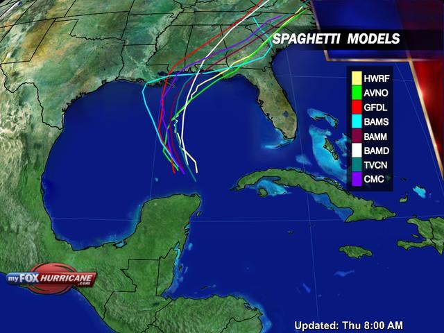
44 CONE WIND ENHANCEMENT
45 SYMONS SAYS: a. Don t just look at the graphics b. Don t just look at the cone c. Don t just look at the long skinny line

46 Little Progress with Intensity Notable improvements in intensity forecasts over the past few years. Beginning of a trend? h intensity forecasts likely to be off by one SSHS category, and off by two SSHS categories perhaps 5-10% of the time
47 Increasing Error (kt) Forecast Intensity Errors NHC 5-Year Averages The 24 and 48 hour NHC intensity forecasts are on average off by one Saffir-Simpson category Forecast Period (Days)
48 Forecast Intensity Errors Rapid Strengthening Rapid intensification remains a forecast challenge and often results in very large errors Our ability to recognize conditions that favor rapid intensification has improved, however forecasting the extent and timing of that intensification remains difficult. 2 Rapid Strengthening Examples Wilma Advisory 11 (2005) Initial Intensity: 60 kt 24h Intensity Forecast: 80 kt Actual Intensity: 150 kt Error: 70 kt Gonzalo Advisory 7 (2014) Initial Intensity: 75 kt 24h Intensity Forecast: 90 kt Actual Intensity: 115 kt Error: 25 kt
49 SYMONS SAYS: A Category 4 hurricane ( mph) causes 250 times the damage as a Category 1 Even though the major hurricanes (Category 3, 4 & 5 storms) comprise only 21% of all U.S. land falling hurricanes, they account for 83 % of all damage.
50 SYMONS SAYS: FORECAST MODELS a. Computer Simulation of the Global Atmosphere b. Dynamical, Statistical, Ensembles,consensus c. The future of Forecasting Ensemble Predictions vs Deterministic d. GFS vs. Euro (Initialization/Members/Grid Spacing) e. The Future High Resolution (4 NM Grid Spacing) Ensemble Forecast System

51 HOW ABOUT THOSE SPAGHETTI PLOTS? I like my pasta al dente Some of those lines are nowhere near my home. Homemade sauce anyone?
52
53 WHEN I WAS IN SCHOOL, I DID VERY WELL IN MATH. WHEN IT COMES TO NUMBERS, I KNOW WHAT I M DOING. 25% CHANCE FOR TROPICAL STORM FORCE WINDS MEANS 75% FOR NONE. NO NEED TO PANIC NO NEED TO PREPARE


54 Wind Speed Probabilities How Likely. Arrival Times. Inland Threat Location-specific probabilities Tropical-storm-force 58 mph Hurricane-force Text product (fixed set of locations) Cumulative probabilities Onset probabilities Graphical product Cumulative probabilities for points over a large domain

55 Wind NHC Speed Tropical Probabilities Cyclone Advisory Products How are they generated? 1,000 realistic alternative scenarios are created Official NHC forecast Historical NHC track and intensity forecast errors Climatology and persistence wind radii model Weakening over land Track model spread Past NHC track forecast errors are correlated to the spread of track model guidance

56 Wind Speed Probabilities How are they generated? New York City, NY 590 of 1,000 scenarios produce tropical storm winds at that location.
57 Wind Speed Probabilities How are they generated? 59% New York City, NY 590/1,000 = 59% chance of TS force winds
58 Wind Speed Probabilities Tropical Storm Isaac (2012) TROPICAL STORM ISAAC WIND SPEED PROBABILITIES NUMBER 21 NWS NATIONAL HURRICANE CENTER MIAMI FL AL UTC SUN AUG WIND SPEED PROBABILITIES FOR SELECTED LOCATIONS FROM FROM FROM FROM FROM FROM FROM TIME 06Z SUN 18Z SUN 06Z MON 18Z MON 06Z TUE 06Z WED 06Z THU PERIODS TO TO TO TO TO TO TO 18Z SUN 06Z MON 18Z MON 06Z TUE 06Z WED 06Z THU 06Z FRI When are Tropical Storm (34kt) winds most likely to start at Pensacola, FL? FORECAST HOUR (12) (24) (36) (48) (72) (96) (120) LOCATION KT PANAMA CITY FL 34 X 3( 3) 22(25) 30(55) 16(71) 2(73) 1(74) PANAMA CITY FL 50 X X( X) 1( 1) 13(14) 15(29) 2(31) 1(32) PANAMA CITY FL 64 X X( X) X( X) 3( 3) 6( 9) 2(11) 1(12) PENSACOLA FL 34 X X( X) 10(10) 32(42) 31(73) 5(78) X(78) PENSACOLA FL 50 X X( X) X( X) 6( 6) 28(34) 5(39) 1(40) PENSACOLA FL 64 X X( X) X( X) 1( 1) 14(15) 3(18) X(18) Pensacola, FL MOBILE AL 34 X X( X) 5( 5) 24(29) 35(64) 8(72) 1(73) MOBILE AL 50 X X( X) X( X) 3( 3) 22(25) 8(33) 1(34) MOBILE AL 64 X X( X) X( X) 1( 1) 8( 9) 4(13) 1(14) GULFPORT MS 34 X X( X) 3( 3) 21(24) 34(58) 10(68) 1(69) GULFPORT MS 50 X X( X) X( X) 2( 2) 19(21) 7(28) 2(30)


59 Wind Speed NHC Tropical Probabilities Cyclone Advisory Products Hurricane Katrina Landfall of a marginal hurricane in South Florida Low probabilities of hurricane force winds Landfall of a major hurricane along the Gulf Coast Increasing probabilities along the forecast as landfall approaches


60 Wind Speed NHC Tropical Probabilities Cyclone Advisory Products Hurricane Katrina Adv #5 10% chance of hurricane-force winds at any individual point along SE Florida coast 36hr Forecast 80 mph Cat 1 Hurricane Low Probability Uncertainty if Katrina will be a hurricane and the small size of hurricane wind field


61 Wind Speed NHC Tropical Probabilities Cyclone Advisory Products Hurricane Katrina Adv #14 New Orleans TS probability: 59% H probability: 15% 72 hour forecast intensity = 130 mph category 4 hurricane Increasing Probabilities Increasing intensity forecast and decrease in track forecast uncertainty 64


62 Wind Speed NHC Tropical Probabilities Cyclone Advisory Products Hurricane Katrina Adv #18 48 hour forecast intensity = 145 mph category 4 hurricane New Orleans TS probability: 86% H probability: 34% High Probability Increasing intensity forecast and greater track certainty 48hr until landfall


63 Hurrevac Hurrevac Wind threat Wind Speed Probabilities 66 66
 64kt(74mph) 64ktEND(dur) 50ktEND(dur) 34ktEND(dur) Peak Wind NC Dare 07/03 22E 07/04 02E 07/04 03E 07/04 06E [03] 07/04 07E [05] 07/04 09E [11] 90kt (104mph) 07/04 04E NC Hyde 07/03 21E")
64 Hurrevac Hurrevac: Wind Timing All Affected Areas Wind timing Report for Hurricane Arthur Based on Advisory 11 Issued 7/3/ AM EDT Wind Timing All Affected Areas Location 34kt(39mph) 50kt(58mph) 64kt(74mph) 64ktEND(dur) 50ktEND(dur) 34ktEND(dur) Peak Wind NC Dare 07/03 22E 07/04 02E 07/04 03E 07/04 06E [03] 07/04 07E [05] 07/04 09E [11] 90kt (104mph) 07/04 04E NC Hyde 07/03 21E 07/04 01E 07/04 02E 07/04 04E [02] 07/04 06E [05] 07/04 08E [11] 90kt (104mph) 07/04 03E NC Carteret 07/03 16E 07/03 21E 07/04 00E 07/04 03E [03] 07/04 04E [07] 07/04 07E [15] 90kt (104mph) 07/04 02E NC Craven 07/03 18E 07/03 23E 07/04 01E 07/04 02E [01] 07/04 03E [04] 07/04 05E [11] 64kt (74mph) 07/04 01E NC Pamlico 07/03 19E 07/04 00E 07/04 04E [04] 07/04 06E [11] 61kt (70mph) 07/04 02E NC Onslow 07/03 15E 07/03 21E 07/04 01E [04] 07/04 04E [13] 60kt (69mph) 07/03 23E NC Tyrrell 07/03 23E 07/04 03E 07/04 06E [03] 07/04 08E [09] 58kt (67mph) 07/04 04E NC Jones 07/03 18E 07/03 22E 07/04 01E [03] 07/04 04E [10] 56kt (64mph) 07/04 00E NC Beaufort 07/03 20E 07/04 01E 07/04 03E [02] 07/04 06E [10] 55kt (63mph) 07/04 02E NC Currituck 07/04 01E 07/04 05E 07/04 06E [01] 07/04 09E [08] 52kt (60mph) 07/04 05E NC Pender 07/03 15E 07/03 21E 07/03 23E [02] 07/04 02E [11] 52kt (60mph) 07/03 21E NC New Hanover 07/03 13E 07/03 18E 07/03 21E [03] 07/04 01E [12] 52kt (60mph) 07/03 19E NC Brunswick 07/03 12E 07/03 18E 07/03 20E [02] 07/04 00E [12] 52kt (60mph) 07/03 18E NC Washington 07/03 23E 07/04 07E [08] 49kt (56mph) 07/04 03E NC Camden 07/04 01E 07/04 08E [07] 46kt (53mph) 07/04 05E MA Nantucket 07/04 21E 07/05 04E [07] 45kt (52mph) 07/05 00E NC Pasquotank 07/04 02E 07/04 08E [06] 44kt (51mph) 07/04 04E 67
65 WIND TIMING CHARTS AND REPORTS BASED UPON A DETERMINISTIC FORCAST DOES NOT ACCOUNT FOR UNCERTAINTIES NOT A GOOD PLATFORM OFF OF WHICH TO MAKE DECISIONS UNTIL THE STORM IS CLOSE GOOD FOR GENERAL INFORMATION AND SITUATIONAL AWARENESS
66 EXPERIMENTAL TIME OF ARRIVAL OF TROPICAL-STORM FORCE WINDS GRAPHIC Winds-A critical Planning Threshold 2. Timing estimated using Deterministic NHC Track 3. Monte Carlo wind Speed Probability Model ( 1000 Plausible Scenarios ) 4. Two graphics: 10% Chance of Onset of Trop Winds 50% chance of Onset of Trop Winds

67 Probability Of Arrival Of Tropical Storm Force Winds
68 SURGE IS,LIKE A TSUNAMI A HIGH WALL OF WATER LIKE WHEN YOU HAVE AN EARTHQUAKE There is nothing out there to tell me whether my area will be flooded except my own eyes and ears. I know an earthquake when I see one.

69 Hurricane Katrina Storm Surge
70 IF THE WIND INCREASES, I WOULD CONSIDER EVACUATION. WIND SPEED IS THE CRITERIA FOR EVACUATION.
71 SYMONS SAYS: Old Hurricane adage Hide from the wind and run from the water.
72 I HAVE THIS MAP COLOR CODED WHERE FLOODING IS LINKED TO CATEGORY OF STORM UNDER THE SAFFIR SIMPSON WIND SCALE. IT TELLS ME HOW FAR THE WATER WILL PENETRATE INLAND. THE STORM IS ONLY A CAT 2 I M HOME FREE Remember Ike, Charlie and Irene


73 LONG ISLAND FLOOD MAP

74 WAVES AND RIP CURRENTS GRANDMA SAYS IF WE GO TO THE BEACH, WE CAN T GO INTO THE WATER BECAUSE IT IS TOO DANGEROUS. DAD SAYS GRANDMA MISSED THE LATEST FORECAST SUNNY AND WARM NOTHING TO WORRY ABOUT.


 - 1 person died in")
75 Waves Tropical and Weather Rip Currents Outlook Can occur when a storm is well offshore Swells from a large hurricane can affect the beach of the entire western Atlantic Hurricane Bertha (2008) - Over 1500 rescues in Ocean City, Maryland - 3 people drowned along the coast of New Jersey Hurricane Bill (2009) - 1 person died in Maine - 1 person died in Florida
76 I HAVE LIVED ALL MY LIFE HERE THE STORMS ALWAYS CURVE AWAY. ANYWAY I AM WORRIED ABOUT WIND NOT WATER.


77 U.S. Tropical Cyclone Deaths Water is responsible for vast majority from
78 SATTELLITES ARE REALLY NOT THAT IMPORTANT SOMEONE TOLD ME THAT IF THE EURO MODEL DID NOT HAVE THE DATA FROM THE 14 POLAR ORBITING SATTELLITES, THE FIVE DAY FORECAST WOULD HAVE HAD SANDY MISSING THE NORTHEAST.

79 ECMWF

80 GOES 16 - High Def from the Heavens a. Launch date 11/19/16 b. 1 st major redesign in more then 20 years c. Image of Conus once / 5 minutes d. Higher Resolution e. Lightning Mapper
81 HURRICANES AND TROPICAL STORMS AFFECT THOSE LIVING ALONG THE COAST. INLAND THERE IS NOTHING TO WORRY ABOUT. INLAND FLOODING RESPONSIBLE FOR 50% + DEATHS
82 WHEN I WAS IN 9TH GRADE, I TOOK EARTH SCIENCE. YES, THAT WAS 30 YEARS AGO BUT I KNOW SOMETHING ABOUT HURRICANES. THIS STORM IS NO SANDY AND NO IRENE.

83 What did we learn?

84 The strongest winds in a hurricane typically are on the left side of the storm.

85 Hurricane Sandy Track Track maximized storm surge
86 STORM SURGE WHAT IS THE MEANING OF 20 OF SURGE? OFTEN THE GREATEST THREAT TO LIFE AND PROPERTY DOES NOT ALWAYS OCCUR AT THE SAME TIME OR LOCATION AS HAZARDOUS WINDS SEPARATE WARNINGS FOR WIND AND WATER 10% EXCEEDENCE VALUE- INUNDATION

87 Storm Tropical Surge Weather Outlook Storm Surge vs Storm Tide STORM SURGE An abnormal rise of water generated by a storm, over and above the predicted astronomical tide. STORM TIDE The water level rise due to the combination of storm surge and the astronomical tide.
88 Tropical Weather Outlook Storm Surge Factors Affecting Storm Surge Intensity Stronger storm = More storm surge Size (RMW) Bigger storm = More storm surge Forward Speed Slower storm = Storm surge farther inland Width and Slope of Shelf (Bathymetry) Gradual shelf = More storm surge Angle of approach Alters focus of storm surge Central Pressure Pressure driven surge about 5% of total storm surge

89 Storm Surge SLOSH Model Sea, Lake, and Overland Surges from Hurricanes A numerical model used to estimate storm surge heights resulting from historical, hypothetical, or predicted hurricanes NHC Tropical Cyclone Advisory Products

90 Storm Surge

91 Storm Tropical Surge Weather Outlook Components of Total Water Level Total Water Level Storm surge + Tides + Wave Setup + Freshwater

92 Tropical Weather Outlook Hurricane Ivan What a difference a bay makes.
93 Hurricane Ivan What a difference a bay makes.

94 Hurricane Ivan What a difference a bay makes. Deterministic SLOSH Limited surge threat to Pensacola area
95 Hurricane Ivan What a difference a bay makes.

96 Probabilistic Storm Surge Multiple Tracks and Landfall Locations Hurricane Irene Advisory #22 Forecast Track Alternate P-surge Tracks

97 Probabilistic NHC Tropical Storm Cyclone Surge Advisory Products Web Based. Timing. Availability. Available when a Hurricane Watch/Warning is in effect 48 hours prior to arrival of TS winds Available approx 1 hour after full advisory times ADVISORY TIME P-SURGE AVAILABLE 0600 EDT 1200 EDT 1800 EDT 0000 EDT
98 SYMONS SAYS: What are two items not included in storm surge watch/warning graphics and inundation?
99 SYMONS SAYS: What are two items not included in storm surge watch/warning graphics and inundation? WAVE ACTION FRESH WATER FLOOD
100 STORM SURGE WATCH/WARNING 1. Life threatening inundation from a tropical cyclone, sub tropical cyclone, post tropical cyclone and maybe a potential tropical cyclone 2. National Storm Surge Hazard Maps- Interactive/ Risk Eval 3. Hurricane local statements 4. NHC public advisory 5. Issuance of watches and advisories for potential tropical cyclones will include potential cyclone advisory package 6. Tropical Tidbits
101 INUNDATION MAP / WATCH WARNING When available?
102 INUNDATION MAP / WATCH WARNING When available? WHEN A WATCH / WARNING IS POSTED OR ANYTIME WITHIN 48 HOURS OF EXPECTED TROPICAL WINDS ON LAND.

103 Storm Surge Potential Inundation Graphic

104 Storm NHC Surge Tropical Warning Cyclone Advisory Products Graphic
105 SYMONS SAYS: The greatest peacetime evacuation in American history was Hurricane Floyd (category 4) in 1999 Over 3.5 million people, from 4 states, (Fla, GA, N.C. and S.C) evacuated. Trips that normally took 2 hours lasted hours. 2 million Floridians left their homes.
106 FLOODING SOURCES a. The sea b. Fresh water c. Rain runoff, river and stream rise Where do we find rainfall forecasts?
107 FLOODING SOURCES a. The sea b. Fresh water c. Rain runoff, river and stream rise Where do we find rainfall forecasts? LOCAL WFO HURRICANE LOCAL STATEMENT OR NHC/NWS (WPC).
108 WHO S THE BOSS NHC OR WFO? a. All Hazards are Local Downscaled and refined at the WFO b. HLS Hurricane Local Statement Lead Statement Areas Covered Watch/Warning Recommend Precautionary Action/Timing Surge and Storm Tide Information

109 National Hurricane Center (NHC) and Weather Forecast Offices (WFO) Work together to provide a clear and consistent tropical message trustworthy message NHC Storm Specific Information Large Scale Storm Intensity, track, size Domain of interest moves with storm Potential Surge Values Wind Values WFO Offices - Downscaled Focus on local storm impacts Domain of interest is local County Warning Area
110 SITUATION OVERVIEW EXTREMELY DANGEROUS HURRICANE WILMA IS EXPECTED TO IMPACT SOUTH FLORIDA BEGINNING THIS EVENING. THE MAIN CONCERN IS FOR LIFE- THREATENING INUNDATION IN SURGE-PRONE AREAS OF COLLIER/MAINLAND NWS Forecast Offices Hurricane Local Statements HURRICANE WILMA LOCAL STATEMENT ADVISORY NUMBER 32 NATIONAL WEATHER SERVICE MIAMI FL AL AM EDT SUN OCT THIS PRODUCT COVERS MAINLAND SOUTH FLORIDA Issued by local NWS office Hurricane (Tropical Storm) Watch/Warning in effect **EXTENSIVE TO DEVASTATING DAMAGE AND LIFE-THREATENING CONDITIONS EXPECTED AS HURRICANE WILMA MOVES NORTHEAST ACROSS SOUTH FLORIDA** NEW INFORMATION * CHANGES TO WATCHES AND WARNINGS: - A HURRICANE WATCH HAS BEEN UPGRADED TO A HURRICANE WARNING FOR MIAMI-DADE BROWARD PALM BEACH COLLIER GLADES AND MONROE COUNTIES * CURRENT WATCHES AND WARNINGS: - A HURRICANE WARNING IS IN EFFECT FOR MIAMI -DADE BROWARD PALM BEACH COLLIER HENDRY GLADES AND MAINLAND MONROE COUNTIES * STORM INFORMATION: - ABOUT 405 MI SW OF NAPLES FL N 86.6W - STORM INTENSITY 100 MPH WITH HIGHER GUSTS - MOVING NORTHEAST AT 3 MPH Situation overview Watch/warning information Potential impact information Preparedness actions

111
112 REMEMBER Biggest single enemy in this high consequence, low probability event is COMPLACENCY!!!
Wind Speed Probability Products
 Wind Speed Probability Products Daniel Brown National Hurricane Center 2018 WMO Course 6 March 2018 Wind Speed Probabilities A Tool to Deal with Uncertainty Hurricane Irene Advisory Number 12 Issued 5:00
Wind Speed Probability Products. Daniel Brown and Michael Brennan National Hurricane Center
 Wind Speed Probability Products Daniel Brown and Michael Brennan National Hurricane Center 2017 WMO Course 7 March 2017 Wind Speed Probabilities A Tool to Deal with Uncertainty Hurricane Irene Advisory
There is a Storm. What s the Info? National Weather Service Tropical Cyclone Products
 NHC Forecasts There is a Storm. What s the Info? National Weather Service Tropical Cyclone Products National Weather Service Tropical Cyclone Products NHC provides the big picture that complements and
Tropical Update. 5 PM EDT Thursday, September 7, 2017 Hurricane Irma, Hurricane Jose, and Hurricane Katia
 Tropical Update 5 PM EDT Thursday, September 7, 2017 Hurricane Irma, Hurricane Jose, and Hurricane Katia This update is intended for government and emergency response officials, and is provided for informational
Tropical Update. 11 AM EDT Tuesday, October 9, 2018 Hurricane Michael, Tropical Storm Leslie, Tropical Storm Nadine
 Tropical Update 11 AM EDT Tuesday, October 9, 2018 Hurricane Michael, Tropical Storm Leslie, Tropical Storm Nadine This update is intended for government and emergency response officials, and is provided
There is a Storm. What s the Info? National Weather Service Tropical Cyclone Products
 NHC Forecasts There is a Storm. What s the Info? National Weather Service Tropical Cyclone Products National Weather Service Tropical Cyclone Products NHC provides the big picture that complements and
Storm Summary for Hurricane Jose
 Storm Summary for Hurricane Jose Tuesday, September 19, 2017 at 11 AM EDT (Output from Hurrevac, based on National Hurricane Center Forecast Advisory #57) Jose is currently a Category 1 hurricane on the
RSMC-Miami Update Daniel Brown Warning Coordination Meteorologist
 RSMC-Miami Update 2016 Daniel Brown Warning Coordination Meteorologist L-0324 Emergency Management Hurricane Preparedness Training Course Funding provided by FEMA s National Hurricane Program - partnership
What s s New for 2009
 What s s New for 2009 Graphical Tropical Weather Outlook becomes operational Special Tropical Disturbance Statement replaced with Special Tropical Weather Outlook Tropical Cyclone Wind Field Graphic becomes
Tropical Update. 5 AM EDT Thursday, September 7, 2017 Hurricane Irma, Hurricane Jose, and Hurricane Katia
 Tropical Update 5 AM EDT Thursday, September 7, 2017 Hurricane Irma, Hurricane Jose, and Hurricane Katia This update is intended for government and emergency response officials, and is provided for informational
Frank Revitte National Weather Service. Weather Forecast Office New Orleans/Baton Rouge
 Frank Revitte National Weather Service Weather Forecast Office New Orleans/Baton Rouge Above normal activity 17 Total Named Storms 7 Tropical Storms 4 Hurricanes 6 Major Hurricanes Not the most active,
Tropical Update. 5 PM EDT Sunday, September 10, 2017 Hurricane Irma, Hurricane Jose, Tropical Wave (60%)
") Tropical Update 5 PM EDT Sunday, September 10, 2017 Hurricane Irma, Hurricane Jose, Tropical Wave (60%) This update is intended for government and emergency response officials, and is provided for informational
Tropical Update 5 PM EDT Sunday, September 10, 2017 Hurricane Irma, Hurricane Jose, Tropical Wave (60%) This update is intended for government and emergency response officials, and is provided for informational
Tropical Update. 5 AM EDT Wednesday, September 6, 2017 Hurricane Irma, Tropical Storm Jose, and Tropical Storm Katia
 Tropical Update 5 AM EDT Wednesday, September 6, 2017 Hurricane Irma, Tropical Storm Jose, and Tropical Storm Katia This update is intended for government and emergency response officials, and is provided
Storm Summary for Hurricane Joaquin
 Storm Summary for Hurricane Joaquin Wednesday, September 30, 2015 at 5 PM EDT (Output from Hurrevac, based on National Hurricane Center Forecast Advisory #12) Joaquin is currently a Category 1 hurricane
National Hurricane Center Products. Jack Beven National Hurricane Center
 National Hurricane Center Products Jack Beven National Hurricane Center Florida Governor s Hurricane Conference 11 May 2014 NHC Tropical Cyclone Products NHC provides the big picture that complements and
NWS HURRICANES June 3, 2015
 NWS HURRICANES June 3, 2015 Hurricane Season June 1 November 30 2 What s the concern? All tropical systems passing within 125nm of central Maryland since 1950 Mid-Atlantic Hurricanes Greatest Risk: August
Tropical Update. 5 AM EDT Monday, October 8, 2018 Tropical Storm Michael, Tropical Storm Leslie, Invest 92L (10%) & African Tropical Wave (50%)
 & African Tropical Wave (50%)") Tropical Update 5 AM EDT Monday, October 8, 2018 Tropical Storm Michael, Tropical Storm Leslie, Invest 92L (10%) & African Tropical Wave (50%) This update is intended for government and emergency response
Tropical Update 5 AM EDT Monday, October 8, 2018 Tropical Storm Michael, Tropical Storm Leslie, Invest 92L (10%) & African Tropical Wave (50%) This update is intended for government and emergency response
Tropical Storm Ana. Created 6:00 AM Sun May 10, 2015 John Cole Warning Coordination Meteorologist
 Tropical Storm Ana Threat Assessment for Eastern North Carolina Created 6:00 AM Sun May 10, 2015 John Cole Warning Coordination Meteorologist John.cole@noaa.gov National Weather Service Newport/Morehead
Tropical Storm Ana. Created 615 AM Sat May 9, 2015 Reid Hawkins, Science Officer
 Tropical Storm Ana Threat Assessment for northeast South Carolina & southeast North Carolina Created 615 AM Sat May 9, 2015 Reid Hawkins, Science Officer National Weather Service Wilmington, NC 1 New Information
Tropical Update. 5 PM EDT Tuesday, September 5, 2017 Hurricane Irma, Tropical Storm Jose, and Tropical Depression Thirteen
 Tropical Update 5 PM EDT Tuesday, September 5, 2017 Hurricane Irma, Tropical Storm Jose, and Tropical Depression Thirteen This update is intended for government and emergency response officials, and is
GC Briefing. Weather Sentinel Tropical Storm Michael. Status at 8 AM EDT (12 UTC) Today (NHC) Discussion. October 11, 2018
 Today (NHC) Discussion. October 11, 2018") GC Briefing Weather Sentinel Tropical Storm Michael October 11, 2018 After making landfall as a high-end category-4 hurricane on the Florida Panhandle, Michael weakened to tropical storm status early this
GC Briefing Weather Sentinel Tropical Storm Michael October 11, 2018 After making landfall as a high-end category-4 hurricane on the Florida Panhandle, Michael weakened to tropical storm status early this
Tropical Update. 11 AM EDT Wednesday, October 10, 2018 Hurricane Michael, Hurricane Leslie & Tropical Storm Nadine, Caribbean Low (40%)
") Tropical Update 11 AM EDT Wednesday, October 10, 2018 Hurricane Michael, Hurricane Leslie & Tropical Storm Nadine, Caribbean Low (40%) This update is intended for government and emergency response officials,
Tropical Update 11 AM EDT Wednesday, October 10, 2018 Hurricane Michael, Hurricane Leslie & Tropical Storm Nadine, Caribbean Low (40%) This update is intended for government and emergency response officials,
The Wind Hazard: Messaging the Wind Threat & Corresponding Potential Impacts
 The Wind Hazard: Messaging the Wind Threat & Corresponding Potential Impacts Scott Spratt Warning Coordination Meteorologist NWS Melbourne, FL David Sharp Science & Operations Officer NWS Melbourne, FL
Hurricane Matthew Page 1 Location Forecast Analysis Summary Report - Advanced Wind Estimation On
 Page 1 Current NHC Forecast Predictions Maximum Sustained Winds / Storm Category: 138 MPH / Category 4 Forward motion: 9 mph towards the North Hurricane Force winds extend from the center: 46 miles Tropical
HVX-HURREVAC (Beta) Webinar Series
 Webinar Series") HVX-HURREVAC (Beta) Webinar Series Day 1 - An introduction to HURREVAC and the new web-based HVX platform 2018 HVX-HURREVAC Webinar Series 1. Intro to HURREVAC and General Overview of the Program (August
HVX-HURREVAC (Beta) Webinar Series Day 1 - An introduction to HURREVAC and the new web-based HVX platform 2018 HVX-HURREVAC Webinar Series 1. Intro to HURREVAC and General Overview of the Program (August
Hurricane Isaac. National Weather Service. Communication Challenges and The Future. Weather Forecast Office New Orleans/Baton Rouge
 Hurricane Isaac Communication Challenges and The Future National Weather Service Weather Forecast Office New Orleans/Baton Rouge Hurricane Isaac Challenges 2012 Tropical Season Season was quiet for Louisiana
TROPICAL STORM NATE BRIEFING
 TROPICAL STORM NATE BRIEFING 5:00 AM CDT Friday, October 6, 2017 Prepared by: NWS NWSNewOrleans www.weather.gov/neworleans Situation Overview No significant changes to the track forecast this morning.
Tropical Update. 12 PM EDT Friday, October 7, 2016 Hurricane Matthew & Tropical Storm Nicole
 Tropical Update 12 PM EDT Friday, October 7, 2016 Hurricane Matthew & Tropical Storm Nicole This update is intended for government and emergency response officials, and is provided for informational and
Tropical Update. 5 PM EDT Sunday, October 7, 2018 Tropical Storm Michael, Tropical Storm Leslie, & Invest 92L (30%)
") Tropical Update 5 PM EDT Sunday, October 7, 2018 Tropical Storm Michael, Tropical Storm Leslie, & Invest 92L (30%) This update is intended for government and emergency response officials, and is provided
Tropical Update 5 PM EDT Sunday, October 7, 2018 Tropical Storm Michael, Tropical Storm Leslie, & Invest 92L (30%) This update is intended for government and emergency response officials, and is provided
Hurricane Matthew Threats and Impacts Briefing for Eastern NC
 Hurricane Matthew Threats and Impacts Briefing for Eastern NC October 6 th, 2016 Date/Time Created: 10/6/2016, Noon EDT National Weather Service Newport/Morehead City, NC Hurricane Matthew Key Points Changes
A Look Back at the 2012 Hurricane Season and a Look Ahead to 2013 & Beyond. Daniel Brown National Hurricane Center Miami, Florida 24 April 2013
 A Look Back at the 2012 Hurricane Season and a Look Ahead to 2013 & Beyond Daniel Brown National Hurricane Center Miami, Florida 24 April 2013 2012 Atlantic Verification Good News- Lots of Accuracy Records
Hurricane Sandy October 28 th 31 st 2012
 Hurricane Sandy October 28 th 31 st 2012 Prepared 530 PM EDT Saturday October 27, 2012 Gary Szatkowski NOAA s NJ Forecast Office Weather.gov/phi Purpose of Briefing Briefing #7 for event Promote situational
Overview of Current Tropical Cyclone Products Generated by NWS
 Overview of Current Tropical Cyclone Products Generated by NWS Todd B. Kimberlain National Hurricane Center HFIP Ensembles Workshop Boulder, Colorado 20 April 2010 National Weather Service hurricane forecast
Hurricane Irma Page 1 HURRTRAK RM/Pro 2017 Summary Report for Tampa, FL 09/10/ EDT, Adv. # 46
 Hurricane Irma Page 1 Description of impact to Tampa, FL, Tampa, FL, is expected to receive a major impact from Hurricane Irma. The forecast maximum wind for this location has increased since the last
Major Hurricane Matthew Briefing Situation Overview
 Major Hurricane Matthew Briefing Situation Overview At 5 p.m. Tuesday, Category 4 Hurricane Matthew was about 860 miles South-Southeast of Mayport, Florida, moving north around 10 mph. Maximum sustained
Tropical Update 6 AM EDT Friday, October 7, 2016 Hurricane Matthew & Hurricane Nicole
 Tropical Update 6 AM EDT Friday, October 7, 2016 Hurricane Matthew & Hurricane Nicole This update is intended for government and emergency response officials, and is provided for informational and situational
Hurricane Matthew. Life Threatening Flash Flooding Likely. National Weather Service Wilmington NC. Josh Weiss, Meteorologist
 Hurricane Matthew Life Threatening Flash Flooding Likely Threat Assessment for northeast South Carolina & southeast North Carolina National Weather Service Wilmington NC 630 PM EDT Friday October 7, 2016
LECTURE #18: Hurricane Damage, Monitoring & Case Study
 GEOL 0820 Ramsey Natural Disasters Spring, 2018 LECTURE #18: Hurricane Damage, Monitoring & Case Study Date: 27 March 2018 I. Exam II grades now posted online o high: 98, low: 46, average: 80 (~3 points
2017 Hurricane Season and Beyond
 2017 Hurricane Season and Beyond Ken Graham National Hurricane Center Building a Weather-Ready Nation Much of U.S. Coast Saw Tropical Wind Watches or Warnings 2017 Hurricane Season Facts and Figures 7th
SLOSH New Orleans Basin 2012 Update
 SLOSH New Orleans Basin 2012 Update Michael Koziara Science and Operations Officer National Weather Service Slidell, LA The Basics What is storm surge? What is SLOSH? Details Assumptions Inundation = Storm
GC Briefing. Weather Sentinel Hurricane Florence. Status at 5 PM EDT (21 UTC) Today (NHC) Discussion. September 13, 2018
 Today (NHC) Discussion. September 13, 2018") GC Briefing September 13, 2018 Weather Sentinel Hurricane Florence Tropical storm conditions have been reported for areas of North Carolina and will continue to spread inland to the west and south. Hurricane
GC Briefing September 13, 2018 Weather Sentinel Hurricane Florence Tropical storm conditions have been reported for areas of North Carolina and will continue to spread inland to the west and south. Hurricane
Subtropical Storm Ana
 Subtropical Storm Ana Threat Assessment for northeast South Carolina & southeast North Carolina Created 745 AM Fri May 8, 2015 Reid Hawkins, Science Officer National Weather Service Wilmington, NC 1 New
Very Dangerous Coastal Storm Sandy October 28 th 31 st 2012
 Very Dangerous Coastal Storm Sandy October 28 th 31 st 2012 Prepared 600 PM EDT Monday October 29, 2012 Gary Szatkowski NOAA s NJ Forecast Office Weather.gov/phi Purpose of Briefing Briefing #11 for event
Hurricane Irma Page 1 HURRTRAK RM/Pro 2017 Summary Report for Tampa, FL 09/09/ EDT, Adv. # 43
 Hurricane Irma Page 1 Description of impact to Tampa, FL, Tampa, FL, is expected to receive a major impact from Hurricane Irma. The forecast maximum wind for this location has decreased since the last
Major Hurricane Matthew Briefing Situation Overview
 Major Hurricane Matthew Briefing Situation Overview THIS IS NOW A WORST CASE STORM SURGE SCENARIO Catastrophic Damage is Anticipated for Coastal Areas. Major Hurricane Matthew is still expected to move
Heavy Rain and Potential for Dangerous Flooding for northeast SC and southeast NC
 US National Weather Service Wilmington NC @NWSWilmingtonNC http://weather.gov/ilm ***Life Threatening Flooding Possible*** Heavy Rain and Potential for Dangerous Flooding for northeast SC and southeast
Hurricane Matthew Life Threatening Flash Flooding Likely
 Hurricane Matthew Life Threatening Flash Flooding Likely Threat Assessment for northeast South Carolina & southeast North Carolina National Weather Service Wilmington NC 12 AM EDT Saturday October 8, 2016
Major Hurricane Earl
 Major Hurricane Earl Advisory 32 North Carolina Threat Assessment Prepared at: 8 AM Thursday September 2, 2010 Hurricane and Tropical Storm Warnings in effect for the North Carolina Coast and Sounds. NWS
Planning for the Threat Preparing for the Impacts The Role of the Local Forecast
 Planning for the Threat Preparing for the Impacts The Role of the Local Forecast 2014 Florida Governor Hurricane Conference Pablo Santos NOAA/NWS WFO Miami, FL 2014 - FLGHC 2014 - FLGHC Decision Support
Coastal Storm Potential
 Coastal Storm Potential Event Date/Time: 11/12/2009-11/14/2009 Today through Saturday National Weather Service Newport/Morehead City, NC Date: 11/12/2009 1000 am Coastal Storm Remnants of Ida, coupled
HURREVAC Webinar Series Day 1 Intro to HURREVAC and General Overview of the Program. National Hurricane Program Training Course
 HURREVAC Webinar Series Day 1 Intro to HURREVAC and General Overview of the Program 2017 HURREVAC Webinar Series 1. Intro to HURREVAC and General Overview of the Program (August 7 th or 14 th ) 2. Evacuation
Tropical Update. 5 PM EDT Thursday, August 27, 2015 Tropical Storm Erika
 Tropical Update 5 PM EDT Thursday, August 27, 2015 Tropical Storm Erika This update is intended for government and emergency response officials, and is provided for informational and situational awareness
Atlantic Basin Satellite Image
 Tropical Update 11 AM EDT Friday, September 7, 2018 Tropical Depression Gordon, Tropical Storm Florence, Potential Tropical Cyclone #8 (90%), Invest 92L (90%) This update is intended for government and
Storm Surge Forecast with Shifting Forecast Tracks
 Storm Surge Forecast with Shifting Forecast Tracks Storm Surge Findings in the Florida Keys Jon Rizzo Warning Coordination Meteorologist National Weather Service Florida Keys Florida Keys Life History
WELCOME TO THE 2018 RA-IV WORKSHOP ON HURRICANE FORECASTING AND WARNING
 WELCOME TO THE 2018 RA-IV WORKSHOP ON HURRICANE FORECASTING AND WARNING Richard J. Pasch and Daniel P. Brown Senior Hurricane Specialists National Hurricane Center ORIENTATION Use of PCs NHC Facility Workshop
Scenario-based Language for Hurricane Decision Support
 Scenario-based Language for Hurricane Decision Support David Sharp NOAA/National Weather Service Melbourne, FL Pablo Santos NOAA/National Weather Service Miami, FL Weather Model Outcomes (as seen on TV)
National Hurricane Program. FEMA Region IV
 National Hurricane Program FEMA Region IV Percent NHP A quick background Hurricane Program major buckets (Toolboxes) Hurricane Evacuation Study HURREVAC Post Storm Assessments Training Hurricane Liaison
Tropical Update. 5 AM EDT Tuesday, September 12, 2017 Post-Tropical Cyclone Irma, Hurricane Jose, & Tropical Wave (10%)
") Tropical Update 5 AM EDT Tuesday, September 12, 2017 Post-Tropical Cyclone Irma, Hurricane Jose, & Tropical Wave (10%) This update is intended for government and emergency response officials, and is provided
Tropical Update 5 AM EDT Tuesday, September 12, 2017 Post-Tropical Cyclone Irma, Hurricane Jose, & Tropical Wave (10%) This update is intended for government and emergency response officials, and is provided
Homework 2: Hurricane Katrina. Part 1. Hurricane Katrina, August 28, 2005 Satellite Imagery
 Metr 302 Homework 2 Fall 2014 Meteorology 302 Fall 2014 Name Homework 2: Hurricane Katrina 100 points total Distributed Thursday 30 October 2014; Due Thursday 13 November 2014 Answer all questions in complete
Tropical Storm Harvey: SE Texas Impacts
 Tropical Storm Harvey: SE Texas Impacts 10 AM CDT UPDATE Thursday, August 24, 2017 Prepared by: Dan Reilly, Brian Kyle PLEASE MUTE YOUR LINES AND DON T PUT ON HOLD! Situation Overview Tropical Storm Harvey
Tropical Update 11 AM EDT Thursday, September 6, 2018 Tropical Depression Gordon, Hurricane Florence, Invest 92L (90%) & African Tropical Wave (50%)
 & African Tropical Wave (50%)") Tropical Update 11 AM EDT Thursday, September 6, 2018 Tropical Depression Gordon, Hurricane Florence, Invest 92L (90%) & African Tropical Wave (50%) This update is intended for government and emergency
Tropical Update 11 AM EDT Thursday, September 6, 2018 Tropical Depression Gordon, Hurricane Florence, Invest 92L (90%) & African Tropical Wave (50%) This update is intended for government and emergency
HURRICANE IRENE. CONFERENCE CALL BRIEFING SLIDES Saturday August 27, :30 AM
 HURRICANE IRENE CONFERENCE CALL BRIEFING SLIDES Saturday August 27, 2011 8:30 AM NHC TRACK AND CONE HURRICANE IRENE WATCHES/WARNINGS Hurricane Warning along south coast including all of Cape Cod and Islands
NHC Ensemble/Probabilistic Guidance Products
 NHC Ensemble/Probabilistic Guidance Products Michael Brennan NOAA/NWS/NCEP/NHC Mark DeMaria NESDIS/STAR HFIP Ensemble Product Development Workshop 21 April 2010 Boulder, CO 1 Current Ensemble/Probability
TROPICAL STORM NATE BRIEFING
 TROPICAL STORM NATE BRIEFING 10:30 AM CDT Friday, October 06, 2017 Prepared by: NWS NWSNewOrleans www.weather.gov/neworleans Situation Overview Track forecast has shifted slightly eastward. Hurricane Watch
Hurricane Charley: A Retrospective 2014 Florida Governor s Hurricane Conference
 Hurricane Charley: A Retrospective 2014 Florida Governor s Hurricane Conference 2004 Hurricane Season: Storm Tracks Satellite Images of 2004 Hurricanes Charley Frances Ivan Jeanne Three Hurricanes in Polk
2008 Hurricane Caravan. Daniel Noah Meteorologist National Weather Service x1 May 22, 2008
 2008 Hurricane Caravan Daniel Noah Meteorologist National Weather Service daniel.noah@noaa.gov, 813-645-2323 x1 May 22, 2008 National Weather Service We never close! Open 24 hours a day 365 days per year
Hurricane Matthew. National Weather Service Wilmington NC. Steven Pfaff, WCM.
 Hurricane Matthew Threat Assessment for northeast South Carolina & southeast North Carolina National Weather Service Wilmington NC 730 AM EDT Tuesday October 4, 2016 Steven Pfaff, WCM Steven.Pfaff@noaa.gov
Communicating Hurricane Threats and Impacts on a National Scale. Daniel Brown Warning Coordination Meteorologist National Hurricane Center
 Communicating Hurricane Threats and Impacts on a National Scale Daniel Brown Warning Coordination Meteorologist National Hurricane Center New NWS Products to Help Communicate Potential Impacts New probabilistic
2015 Hurricane Season Outlook and Preparedness. Amy Godsey State Meteorologist State Emergency Response Team Florida Division of Emergency Management
 2015 Hurricane Season Outlook and Preparedness Amy Godsey State Meteorologist State Emergency Response Team Florida Division of Emergency Management 2015 Hurricane Season Last Hurricane Landfall: Kate
Major Hurricane Earl
 Major Hurricane Earl Advisory 33 North Carolina Threat Assessment Prepared at: 11 AM Thursday September 2, 2010 Hurricane and Tropical Storm Warnings in effect for the North Carolina Coast and Sounds NWS
Current Details from the National Hurricane Center (NHC)
") Current Watches and Warnings A Hurricane Warning is in effect from Port Mansfield to Sargent, Texas A Warning is in effect from north of Sargent to High Island, Texas A Surge Warning is in effect from
Current Watches and Warnings A Hurricane Warning is in effect from Port Mansfield to Sargent, Texas A Warning is in effect from north of Sargent to High Island, Texas A Surge Warning is in effect from
TROPICAL STORM NATE BRIEFING
 TROPICAL STORM NATE BRIEFING 2:00 PM CDT Friday, October 06, 2017 Prepared by: NWS NWSNewOrleans www.weather.gov/neworleans Situation Overview Track forecast has not changed since the 10 am advisory. Hurricane
HURRICANE IRMA. 12 PM ET Saturday, September Prepared by: Kyle Thiem / Sid King.
 HURRICANE IRMA 12 PM ET Saturday, September 9 2017 Prepared by: Kyle Thiem / Sid King www.weather.gov/atlanta/briefings @NWSAtlanta www.weather.gov/atlanta Situation Overview 11:00 AM EDT Sat Sep 9 Location:
Experimental Probabilistic Hurricane Inundation Surge Height (PHISH) Guidance
 Guidance") Experimental Probabilistic Hurricane Inundation Surge Height (PHISH) Guidance DRBC Flood Advisory Committee John Kuhn - NWS/OCWWS Anne Myckow (NWS/MDL), Arthur Taylor (NWS/MDL) SLOSH Sea, Lake and Overland
Experimental Probabilistic Hurricane Inundation Surge Height (PHISH) Guidance DRBC Flood Advisory Committee John Kuhn - NWS/OCWWS Anne Myckow (NWS/MDL), Arthur Taylor (NWS/MDL) SLOSH Sea, Lake and Overland
Current Details from the National Hurricane Center (NHC)
") Current Watches/Warnings A Hurricane Warning is in effect from Surf City, North Carolina to the North Carolina/Virginia border; Pamlico Sound; Eastern Albemarle Sound A Hurricane Watch is in effect from
Current Watches/Warnings A Hurricane Warning is in effect from Surf City, North Carolina to the North Carolina/Virginia border; Pamlico Sound; Eastern Albemarle Sound A Hurricane Watch is in effect from
HURRICANE NATE BRIEFING
 HURRICANE NATE BRIEFING 2:00 PM CDT Saturday, October 07, 2017 Prepared by: NWS NWSNewOrleans www.weather.gov/neworleans Situation Overview continues to intensify. It is now forecast to be a category 2
NOAA s National Weather Service Philadelphia/Mt. Holly NJ
 Next Briefing Package: Friday, October 2, 2015 no later than 300 PM Hazards and Impacts: Overview: A dangerous weather pattern still threatens our region. Threats include very heavy rainfall, inland river
Active Weather Threat Halloween Week Nor easter October 28 th 31 st 2012
 Active Weather Threat Halloween Week Nor easter October 28 th 31 st 2012 Prepared 1130 AM EDT Wednesday, October 24, 2012 Gary Szatkowski NOAA s NJ Forecast Office Weather.gov/phi Purpose of Briefing Briefing
Outlook 2008 Atlantic Hurricane Season. Kevin Lipton, Ingrid Amberger National Weather Service Albany, New York
 Outlook 2008 Atlantic Hurricane Season Kevin Lipton, Ingrid Amberger National Weather Service Albany, New York Summary 2007 Hurricane Season Two hurricanes made landfall in the Atlantic Basin at category-5
The Local Wind Forecast and Its Uncertainty (Completing the Wind Forecast)
") The Local Wind Forecast and Its Uncertainty (Completing the Wind Forecast) Florida Governor Hurricane Conference May 11-16 2014 Pablo Santos Meteorologist In Charge NWS Miami/South Florida Forecast Office
The Local Wind Forecast and Its Uncertainty (Completing the Wind Forecast) Florida Governor Hurricane Conference May 11-16 2014 Pablo Santos Meteorologist In Charge NWS Miami/South Florida Forecast Office
Canes on Canes: Keeping South Florida Prepared During the Calm Before the Storm. Matt Onderlinde and Pete Finocchio
 Canes on Canes: Keeping South Florida Prepared During the Calm Before the Storm Matt Onderlinde and Pete Finocchio Outline The Science of Hurricanes Why and When South Floridians Must Be Weather-Ready
Tropical Weather Briefing
 Tropical Weather Briefing August 28, 2012 700 AM CDT National Weather Service Weather Forecast Office Slidell, LA Current Satellite Tropical Storm Isaac Watches/Warnings Tropical Storm Isaac Track Guidance
Weather Briefing. Coastal Storm Monday-Wednesday Dec 8-10, National Weather Service. Prepared 12/8/14 6:30 AM
 Weather Briefing Coastal Storm Monday-Wednesday Dec 8-10, 2014 National Weather Service http://www.weather.gov/nyc Prepared 12/8/14 6:30 AM Overview of Potential Hazards A strong low pressure system will
Hurricane Matthew. National Weather Service Wilmington NC. Steven Pfaff, WCM.
 Hurricane Matthew Threat Assessment for northeast South Carolina & southeast North Carolina National Weather Service Wilmington NC 515 PM EDT Monday October 3, 2016 Steven Pfaff, WCM Steven.Pfaff@noaa.gov
WEDNESDAY 30 TH AUGUST, :57 p.m. Tropical Storm Irma forms in the Atlantic. Don t let your guard down, always #Be Ready.
 Chapter 1 - The Set Up In the days leading up to Irma a series of composed and sobering text messages, presented in truncated form below, from Department of Disaster Management warned us of the pending
NOAA s National Weather Service Philadelphia/Mt. Holly NJ
 Next Briefing Package: Thursday, October 1, 2015 no later than 300 PM Hazards and Impacts: Overview: A dangerous weather pattern is developing for our region. Threats include very heavy rainfall, inland
ERTH 365 Homework #2: Hurricane Harvey. 100 points
 ERTH 365 Homework #2: Hurricane Harvey 100 points Due by 6pm, Tuesday 30 October 2018, ELECTRONIC SUBMISSON BY EMAIL ONLY BY 6PM (send to klevey@sfsu.edu) (acceptable formats: MS Word, Google Doc, plain
Ch. 11: Hurricanes. Be able to. Define what hurricane is. Identify the life and death of a hurricane. Identify the ways we track hurricanes.
 Ch. 11: Hurricanes Be able to Define what hurricane is. Identify the life and death of a hurricane. Identify the ways we track hurricanes. What are Hurricanes? Smaller than mid-latitude cyclones. Don t
HURRICANE HARVEY COE Navigation BRIEFING
 HURRICANE HARVEY COE Navigation BRIEFING 10:00 AM CDT Friday, August 25, 2017 NWSNewOrleans www.weather.gov/neworleans Situation Overview New Information Harvey continues to strengthen Max sustained winds
 Hazard Warnings GE 4150 Natural Hazards September 17, 2007 http://www.sdr.gov/ndis_rev_oct27.pdf Sorensen, J.H. (2000) Hazard warning systems: Review of 20 years of progress. Natural Hazards Review, May,
MIAMI-SOUTH FLORIDA National Weather Service Forecast Office
 MIAMI-SOUTH FLORIDA National Weather Service Forecast Office http://www.weather.gov/miami June 2015 South Florida Weather Summary Dry East, Wet West...Drought Remains SE Florida July 3, 2015: Depending
Chapter 16, Part Hurricane Paths. 2. Hurricane Paths. Hurricane Paths and Damage
 Chapter 16, Part 2 Hurricane Paths and Damage 1. Hurricane Paths Start over tropical water except South Atlantic and eastern South Atlantic, where water is too cold. Initially steered by easterly winds
30 If Vmax > 150, HSI intensity pts = 25
 Hurricane Severity Index: A New Way of Estimating a Tropical Cyclone s Destructive Potential 1. Introduction Christopher G. Hebert*, Robert A. Weinzapfel*, Mark A. Chambers* Impactweather, Inc., Houston,
Hurricanes. Hurricanes are large, tropical storm systems that form and develop over the warm waters near the equator.
 Hurricanes Hurricanes are large, tropical storm systems that form and develop over the warm waters near the equator. They are responsible for weather that can devastate entire communities: Heavy rain --
Current Details from the National Hurricane Center (NHC)
") Current Watches and Warnings A Hurricane Warning is in effect from Port Mansfield to Matagorda, Texas A Warning is in effect from north of Matagorda to High Island, Texas; south of Port Mansfield, Texas
Current Watches and Warnings A Hurricane Warning is in effect from Port Mansfield to Matagorda, Texas A Warning is in effect from north of Matagorda to High Island, Texas; south of Port Mansfield, Texas
NWS Resources For School Districts
 NWS Resources For School Districts January 23rd, 2017 Shawn DeVinny shawn.devinny@noaa.gov Meteorologist National Weather Service Twin Cities/Chanhassen, MN Outline Watches/Warnings/Advisories Example
National Situation Report As of 3:00 a.m. EDT, Thursday, September 21, 2017 Table of Contents Current Operations Monitoring Recovery
 25k Overview National Situation Report As of 3:00 a.m. EDT, Thursday, September 21, 2017 Table of Contents Current Operations Monitoring Recovery FEMA Headquarters Status FEMA Region Status NRCC Level
10 years after Hurricane Charley
 10 years after Hurricane Charley Hurricane Charley (2004) A Retrospective Scott M. Spratt Warning Coordination Meteorologist NWS Melbourne, FL Florida Governors Hurricane Conference May 15, 2014 11 AM
Nor easter Monday Night Wednesday December 8 10, 2014
 Nor easter Monday Night Wednesday December 8 10, 2014 Prepared 400 PM EST Monday, December 8, 2014 Mitchell Gaines NOAA s Philadelphia/Mount Holly NJ Forecast Office www.weather.gov/phi/ Purpose of Briefing
Unit 7 Section 3 Computer Lab. Part 1: OPEN OCEAN AND COASTAL IMPACTS OF TROPICAL CYCLONES
 Unit 7 Section 3 Computer Lab Part 1: OPEN OCEAN AND COASTAL IMPACTS OF TROPICAL CYCLONES Educational Outcomes: Tropical cyclones are significant phenomena in the Earth system. They are as much oceanic