Overview of Current Tropical Cyclone Products Generated by NWS
|
|
|
- Eugenia Fitzgerald
- 5 years ago
- Views:
Transcription


1 Overview of Current Tropical Cyclone Products Generated by NWS Todd B. Kimberlain National Hurricane Center HFIP Ensembles Workshop Boulder, Colorado 20 April 2010

2 National Weather Service hurricane forecast and warning products are like a mosaic The National Hurricane Center paints the big picture... and the local Weather Forecast Offices tell the local story
3 Text Products Tropical Weather Outlook Special Tropical Weather Outlook Tropical Weather Discussion Public Advisory Intermediate Advisory Forecast Advisory Forecast Discussion Surface Wind Speed Probabilities ICAO (Aviation) Advisory Update Position Estimate Valid Time Event Code Monthly Weather Summary Tropical Cyclone Reports Graphical Products Graphical Tropical Weather Outlook Track Forecast Cone Surface Wind Field Surface Wind Speed Probabilities Cumulative Wind History Maximum 1-min Wind Speed Probability Storm Surge Probabilities Experimental GIS Products Podcasts (Audio) Media Videocast Briefings NHC Web Widgets
4 Tropical Weather Outlook ABNT20 KNHC (MIATWOAT) Atlantic ABPZ20 KNHC (MIATWOEP) East Pacific discussion of significant areas of disturbed weather potential for development within 48 hours brief description of active tropical or subtropical cyclones non-technical explanation of meteorology FOR THE NORTH ATLANTIC...CARIBBEAN SEA AND THE GULF OF MEXICO... THE NATIONAL HURRICANE CENTER IS ISSUING ADVISORIES ON TROPICAL STORM HANNA...LOCATED ABOUT 75 MILES EAST-SOUTHEAST OF MARSH HARBOR IN THE BAHAMAS...ON HURRICANE IKE...LOCATED ABOUT 505 MILES NORTH-NORTHEAST OF THE LEEWARD ISLANDS...AND ON TROPICAL STORM JOSEPHINE...LOCATED ABOUT 590 MILES WEST OF THE SOUTHERNMOST CAPE VERDE ISLANDS. SHOWERS AND THUNDERSTORMS HAVE DECREASED THIS EVENING IN ASSOCIATION WITH AN AREA OF DISTURBED WEATHER LOCATED ABOUT MIDWAY BETWEEN AFRICA AND THE LESSER ANTILLES. DEVELOPMENT...IF ANY...IS EXPECTED TO BE SLOW TO OCCUR DUE TO UNFAVORABLE UPPER-LEVEL WIND AS THE SYSTEM MOVES WESTWARD AT 10 TO 15 MPH. THERE IS A LOW CHANCE...20 PERCENT...OF THIS SYSTEM BECOMING A TROPICAL CYCLONE DURING THE NEXT 48 HOURS. ELSEWHERE...TROPICAL CYCLONE FORMATION IS NOT EXPECTED DURING THE NEXT 48 HOURS. $$ FORECASTER XXXX 200 am 800 am 200 pm 800 pm EDT 500 am 1100 am 500 pm 1100 pm PDT

")
5 Graphical Tropical Weather Outlook mirrors the text TWO issued at same time as text TWO High > 50% Medium 30 50% Low < 30% (20%) (40%) (70%)
: tropical cyclones, subtropical cyclones, areas of possible cyclogenesis Tropical waves")
6 Tropical Weather Discussion AXNT20 KNHC (MIATWDAT) Atlantic AXPZ20 KNHC (MIATWDEP) East Pacific 205 am 805 am 205 pm 805 pm EDT 305 am 905 am 305 pm 905 pm PDT issued year-round describes major synoptic weather features and areas of disturbed weather 4 sections: Special features (eventdriven): tropical cyclones, subtropical cyclones, areas of possible cyclogenesis Tropical waves (event-driven) ITCZ Discussion

7 Public Advisory (NEW FORMAT) WTNT31-35 KNHC (MIATCPAT1-5) Atlantic WTPZ31-35 KNHC (MIATCPEP1-5) East Pacific Plain-language text product originally intended for rip and read Headline or lead statement Summary information Watches and warnings Center location, motion, forecast Wind speed and forecast Hazards: Wind / Storm surge / Rainfall / Tornadoes / Waves and Rip Currents Recommended actions 500 am 1100 am 500 pm 1100 pm EDT 200 am 800 am 200 pm 800 pm PDT
8 New Public Advisory Format Section headers added Storm information first Changes to watches and warnings in the current advisory are highlighted Bulleted summary of all watches and warnings in effect
9 New Public Advisory Format Section headers Discussion of forecast motion and intensity and other pertinent information Storm hazards and impacts, shown by type


10 NHC Tropical Cyclone Advisory Products Intermediate Public Advisory Provides continuous flow of information Issued when watches or warnings are in effect Issued 3-hourly or 2-hourly if welldefined center within NWS radar range Not used to issue watches or warnings Content similar to routine public advisories

11 Forecast / Advisory WTNT21-25 KNHC (MIATCMAT1-5) Atlantic WTPZ21-25 KNHC (MIATCMEP1-5) E. Pacific 500 am 1100 am 500 pm 1100 pm EDT 200 am 800 am 200 pm 800 pm PDT Only source of all the forecast data Data is used in HURREVAC and other commercial tracking software Watches and warnings Center location, motion, minimum pressure and eye diameter Forecast positions, intensity and wind radii
12 Tropical Cyclone Discussion WTNT41-45 KNHC (MIATCDAT1-5) Atlantic WTPZ41-45 KNHC (MIATCDEP1-5) E. Pacific Free-form text product Provides the reasoning behind forecasts and warnings Discussion of relevant observations, model guidance, and the forecast uncertainties Includes table of track and intensity forecasts 500 am 1100 am 500 pm 1100 pm EDT 200 am 800 am 200 pm 800 pm PDT

13 Special Advisories Special advisory packages are issued when: Watches or warnings are required immediately Or when an unexpected significant change has occurred.
14 Update WTNT61-65 KNHC (MIATCUAT1-5) Atlantic WTPZ61-65 KNHC (MIATCUEP1-5) East Pacific HURRICANE IKE TROPICAL CYCLONE UPDATE NWS TPC/NATIONAL HURRICANE CENTER MIAMI FL AL PM EDT SUN SEP IKE MAKES LANDFALL IN EASTERN CUBA... THE EYE OF HURRICANE IKE MADE LANDFALL ON THE NORTH COAST OF EASTERN CUBA IN THE PROVINCE OF HOLGUIN...NEAR PUNTO DE SAMA AROUND 0945 PM EDT UTC. MAXIMUM WINDS AT LANDFALL WERE ESTIMATED TO BE 125 MPH KM/HR. Position Estimate WTNT51-55 KNHC (MIATCEAT1-5) Atlantic WTPZ51-55 KNHC (MIATCEEP1-5) East Pacific HURRICANE IKE TROPICAL CYCLONE POSITION ESTIMATE NWS TPC/NATIONAL HURRICANE CENTER MIAMI FL AL AM CDT SAT SEP AT 7 AM CDT Z...THE CENTER OF HURRICANE IKE WAS ESTIMATED BY NOAA DOPPLER WEATHER RADARS TO BE NEAR LATITUDE 30.3 NORTH... LONGITUDE 95.3 WEST OR NEAR CONROE TEXAS. THIS IS ALSO ABOUT 70 MILES KM...SOUTH-SOUTHWEST OF LUFKIN TEXAS. Issued for: Landfall Unexpected changes Issuance of international watches / warnings Issued between 2- hourly intermediate advisories when well-defined center within 200 nm of radar range
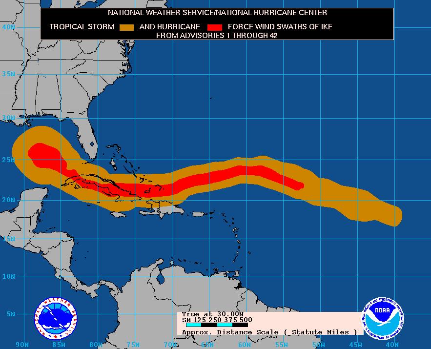
 Position and Intensity 34 kt wind radii 50 kt wind radii 64 kt")
15 Overview of TC products The National Hurricane Center issues - 72-hour forecast of track positions, intensity, and wind speed radii and 120-hour track positions and intensities. Also included are - watches and warnings - brief storm surge, tornado, and rainfall statements Forecast Hour 3 (advisory issuance time) Position and Intensity 34 kt wind radii 50 kt wind radii 64 kt wind radii 12 ft seas 12 (TAFB/OPC) 24 (Day 1) (TAFB/OPC) 36 (TAFB/OPC) 48 (Day 2) (TAFB/OPC) 72 (Day 3) (TAFB/OPC) 96 (Day 4) (TAFB/OPC) 120 (Day 5) (TAFB/OPC) 144+ (Day 6+) [NHC/HPC]


16 Estimates of the Surface Wind Field There are insufficient observations of surface wind in tropical cyclones to accurately specify the wind field. Intensity estimates believed good to within 10%, with TS wind radii to within 25%, H radii to within 40%. Maximum extent of winds by quadrant from Tropical Cyclone Forecast/Advisory: 64 KT... 45NE 30SE 25SW 30NW. 50 KT...120NE 75SE 60SW 75NW. 34 KT...175NE 140SE 120SW 120NW.

17 Cumulative Wind History
 Size of the circles determined so that, say, the actual storm position at 48 h will be within the 48-h circle 67% of the time.")
18 NHC Forecast Cone Represents the probable track of the center of the tropical cyclone. Formed by connecting circles centered on each forecast point (at 12, 24, 36 h, etc.) Size of the circles determined so that, say, the actual storm position at 48 h will be within the 48-h circle 67% of the time. Forecast Period (h) 2009 Circle Radius (n mi) ( errors) 2010 Circle Radius (n mi) ( errors)
19 Surface Wind Speed Probabilities FONT11-15 KNHC (MIAPWSAT1-5) Atlantic FOPZ11-15 KNHC (MIAPWSEP1-5) East Pacific ZCZC MIAPWSAT4 ALL TTAA00 KNHC DDHHMM HURRICANE IKE WIND SPEED PROBABILITIES NUMBER 47 NWS TPC/NATIONAL HURRICANE CENTER MIAMI FL AL UTC FRI SEP AT 2100Z THE CENTER OF HURRICANE IKE WAS LOCATED NEAR LATITUDE 27.7 NORTH...LONGITUDE 93.5 WEST WITH MAXIMUM SUSTAINED WINDS NEAR 90 KTS MPH KM/HR. Z INDICATES COORDINATED UNIVERSAL TIME (GREENWICH) ATLANTIC STANDARD TIME (AST)...SUBTRACT 4 HOURS FROM Z TIME EASTERN DAYLIGHT TIME (EDT)...SUBTRACT 4 HOURS FROM Z TIME CENTRAL DAYLIGHT TIME (CDT)...SUBTRACT 5 HOURS FROM Z TIME I. MAXIMUM WIND SPEED (INTENSITY) PROBABILITY TABLE CHANCES THAT THE MAXIMUM SUSTAINED (1-MINUTE AVERAGE) WIND SPEED OF THE TROPICAL CYCLONE WILL BE WITHIN ANY OF THE FOLLOWING CATEGORIES AT EACH OFFICIAL FORECAST TIME DURING THE NEXT 5 DAYS. PROBABILITIES ARE GIVEN IN PERCENT. X INDICATES PROBABILITIES LESS THAN 1 PERCENT. 500 am 1100 am 500 pm 1100 pm EDT 200 am 800 am 200 pm 800 pm PDT II. WIND SPEED PROBABILITY TABLE FOR SPECIFIC LOCATIONS CHANCES OF SUSTAINED (1-MINUTE AVERAGE) WIND SPEEDS OF AT LEAST...34 KT (39 MPH KPH) KT (58 MPH KPH) KT (74 MPH KPH)... FOR LOCATIONS AND TIME PERIODS DURING THE NEXT 5 DAYS PROBABILITIES FOR LOCATIONS ARE GIVEN AS IP(CP) WHERE IP IS THE PROBABILITY OF THE EVENT BEGINNING DURING AN INDIVIDUAL TIME PERIOD (INDIVIDUAL PROBABILITY) (CP) IS THE PROBABILITY OF THE EVENT OCCURRING BETWEEN 18Z FRI AND THE FORECAST HOUR (CUMULATIVE PROBABILITY) PROBABILITIES ARE GIVEN IN PERCENT X INDICATES PROBABILITIES LESS THAN 1 PERCENT PROBABILITIES FOR 34 KT AND 50 KT ARE SHOWN AT A GIVEN LOCATION WHEN THE 5-DAY CUMULATIVE PROBABILITY IS AT LEAST 3 PERCENT. PROBABILITIES FOR 64 KT ARE SHOWN WHEN THE 5-DAY CUMULATIVE PROBABILITY IS AT LEAST 1 PERCENT MAXIMUM WIND SPEED (INTENSITY) PROBABILITIES VALID TIME 06Z SAT 18Z SAT 06Z SUN 18Z SUN 18Z MON 18Z TUE 18Z WED FORECAST HOUR DISSIPATED X X NA NA NA TROP DEPRESSION X NA NA NA TROPICAL STORM NA NA NA HURRICANE X X NA NA NA HUR CAT X X NA NA NA HUR CAT X X NA NA NA HUR CAT 3 22 X X X NA NA NA HUR CAT 4 1 X X X NA NA NA HUR CAT 5 X X X X NA NA NA FCST MAX WIND 95KT 65KT 30KT 30KT NA NA NA WIND SPEED PROBABILITIES FOR SELECTED LOCATIONS FROM FROM FROM FROM FROM FROM FROM TIME 18Z FRI 06Z SAT 18Z SAT 06Z SUN 18Z SUN 18Z MON 18Z TUE PERIODS TO TO TO TO TO TO TO 06Z SAT 18Z SAT 06Z SUN 18Z SUN 18Z MON 18Z TUE 18Z WED FORECAST HOUR (12) (24) (36) (48) (72) (96) (120) LOCATION KT GULFPORT MS ( 6) X( 6) X( 6) X( 6) X( 6) X( 6) BURAS LA (11) X(11) X(11) X(11) X(11) X(11) GFMX 280N 890W 34 6 X( 6) X( 6) X( 6) X( 6) X( 6) X( 6) JACKSON MS ( 9) 1(10) X(10) X(10) X(10) X(10)

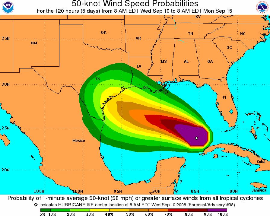
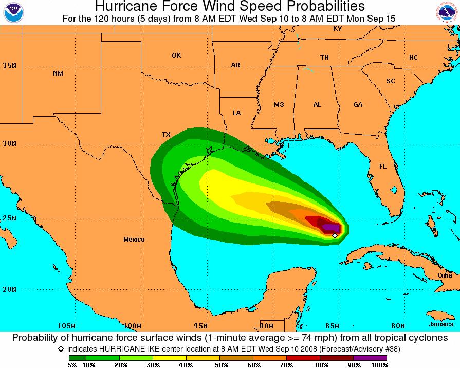

20 Surface Wind Speed Probabilities Maximum 1-minute Wind Speed Probability
 SHORT FUSED: Extreme Wind Warning (EWW) Tornado Warning (TOR) Flash Flood Warning (FFW) Special Marine Warning (SMW.")
21 WFO Tropical Cyclone Products LONG FUSED: Hazardous Weather Outlook (HWO) Public Information Statements (PNS) Special Weather Statements (SPS) Hurricane Local Statement (HLS) Tropical Storm/Hurricane Wind Watch/Warning Flood Watch (FFA) SHORT FUSED: Extreme Wind Warning (EWW) Tornado Warning (TOR) Flash Flood Warning (FFW) Special Marine Warning (SMW...waterspouts) Severe Weather Statement (SVS)

22 WFO Tropical Cyclone Products Hurricane Local Statement (HLS) - Highlights expected impacts from multiple storm hazards over the local region. - WFOs begin issuing product as soon as initial watches or warnings are issued. Can also be issued when evacuation orders are issued, as well as to dispel rumors. - Text and graphical versions. - Issued around NHC advisory package, but can be updated at any time.

23 Graphical HLS Impact levels determined by combination of objective and subjective techniques. Takes into account probabilistic information, with a subjective human element involved. Descriptions of impacts by category are locally defined for each area.


24 WFO Graphical HLS Mouse-over feature for impact level description 24
. Very time, location and IMPACT specific.")
25 Extreme Wind Warning Extreme Wind Warnings provide a new and powerful tool for WFOs to issue an EAS-activated warning just prior to destructive wind onset (radar-based; 4-min update frequency). For final action, shelter in place: Extreme Wind Warning: lead time 1 hour & average length ~50 nm (equivalent to approximately 4 small-sized counties). Very time, location and IMPACT specific. Only for sustained surface winds of 115 mph or greater (1.2 gust factor = 140 mph gusts); non-tropical SVR = 58 mph gusts!


26 Archive Web Site ALL text and graphical products
National Hurricane Center Products. Jack Beven National Hurricane Center
 National Hurricane Center Products Jack Beven National Hurricane Center Florida Governor s Hurricane Conference 11 May 2014 NHC Tropical Cyclone Products NHC provides the big picture that complements and
Tropical Update. 5 PM EDT Sunday, September 10, 2017 Hurricane Irma, Hurricane Jose, Tropical Wave (60%)
") Tropical Update 5 PM EDT Sunday, September 10, 2017 Hurricane Irma, Hurricane Jose, Tropical Wave (60%) This update is intended for government and emergency response officials, and is provided for informational
Tropical Update 5 PM EDT Sunday, September 10, 2017 Hurricane Irma, Hurricane Jose, Tropical Wave (60%) This update is intended for government and emergency response officials, and is provided for informational
What s s New for 2009
 What s s New for 2009 Graphical Tropical Weather Outlook becomes operational Special Tropical Disturbance Statement replaced with Special Tropical Weather Outlook Tropical Cyclone Wind Field Graphic becomes
Storm Summary for Hurricane Jose
 Storm Summary for Hurricane Jose Tuesday, September 19, 2017 at 11 AM EDT (Output from Hurrevac, based on National Hurricane Center Forecast Advisory #57) Jose is currently a Category 1 hurricane on the
Wind Speed Probability Products
 Wind Speed Probability Products Daniel Brown National Hurricane Center 2018 WMO Course 6 March 2018 Wind Speed Probabilities A Tool to Deal with Uncertainty Hurricane Irene Advisory Number 12 Issued 5:00
Wind Speed Probability Products. Daniel Brown and Michael Brennan National Hurricane Center
 Wind Speed Probability Products Daniel Brown and Michael Brennan National Hurricane Center 2017 WMO Course 7 March 2017 Wind Speed Probabilities A Tool to Deal with Uncertainty Hurricane Irene Advisory
A Look Back at the 2012 Hurricane Season and a Look Ahead to 2013 & Beyond. Daniel Brown National Hurricane Center Miami, Florida 24 April 2013
 A Look Back at the 2012 Hurricane Season and a Look Ahead to 2013 & Beyond Daniel Brown National Hurricane Center Miami, Florida 24 April 2013 2012 Atlantic Verification Good News- Lots of Accuracy Records
Tropical Update. 11 AM EDT Tuesday, October 9, 2018 Hurricane Michael, Tropical Storm Leslie, Tropical Storm Nadine
 Tropical Update 11 AM EDT Tuesday, October 9, 2018 Hurricane Michael, Tropical Storm Leslie, Tropical Storm Nadine This update is intended for government and emergency response officials, and is provided
Tropical Update. 5 AM EDT Thursday, September 7, 2017 Hurricane Irma, Hurricane Jose, and Hurricane Katia
 Tropical Update 5 AM EDT Thursday, September 7, 2017 Hurricane Irma, Hurricane Jose, and Hurricane Katia This update is intended for government and emergency response officials, and is provided for informational
RSMC-Miami Update Daniel Brown Warning Coordination Meteorologist
 RSMC-Miami Update 2016 Daniel Brown Warning Coordination Meteorologist L-0324 Emergency Management Hurricane Preparedness Training Course Funding provided by FEMA s National Hurricane Program - partnership
Storm Summary for Hurricane Joaquin
 Storm Summary for Hurricane Joaquin Wednesday, September 30, 2015 at 5 PM EDT (Output from Hurrevac, based on National Hurricane Center Forecast Advisory #12) Joaquin is currently a Category 1 hurricane
There is a Storm. What s the Info? National Weather Service Tropical Cyclone Products
 NHC Forecasts There is a Storm. What s the Info? National Weather Service Tropical Cyclone Products National Weather Service Tropical Cyclone Products NHC provides the big picture that complements and
Tropical Update. 5 AM EDT Wednesday, September 6, 2017 Hurricane Irma, Tropical Storm Jose, and Tropical Storm Katia
 Tropical Update 5 AM EDT Wednesday, September 6, 2017 Hurricane Irma, Tropical Storm Jose, and Tropical Storm Katia This update is intended for government and emergency response officials, and is provided
Tropical Update. 5 PM EDT Thursday, August 27, 2015 Tropical Storm Erika
 Tropical Update 5 PM EDT Thursday, August 27, 2015 Tropical Storm Erika This update is intended for government and emergency response officials, and is provided for informational and situational awareness
HVX-HURREVAC (Beta) Webinar Series
 Webinar Series") HVX-HURREVAC (Beta) Webinar Series Day 1 - An introduction to HURREVAC and the new web-based HVX platform 2018 HVX-HURREVAC Webinar Series 1. Intro to HURREVAC and General Overview of the Program (August
HVX-HURREVAC (Beta) Webinar Series Day 1 - An introduction to HURREVAC and the new web-based HVX platform 2018 HVX-HURREVAC Webinar Series 1. Intro to HURREVAC and General Overview of the Program (August
WELCOME TO THE 2018 RA-IV WORKSHOP ON HURRICANE FORECASTING AND WARNING
 WELCOME TO THE 2018 RA-IV WORKSHOP ON HURRICANE FORECASTING AND WARNING Richard J. Pasch and Daniel P. Brown Senior Hurricane Specialists National Hurricane Center ORIENTATION Use of PCs NHC Facility Workshop
Tropical Update. 5 PM EDT Tuesday, September 5, 2017 Hurricane Irma, Tropical Storm Jose, and Tropical Depression Thirteen
 Tropical Update 5 PM EDT Tuesday, September 5, 2017 Hurricane Irma, Tropical Storm Jose, and Tropical Depression Thirteen This update is intended for government and emergency response officials, and is
WEEKLY WEATHER OUTLOOK BELIZE, CENTRAL AMERICA
 WEEKLY WEATHER OUTLOOK BELIZE, CENTRAL AMERICA PERIOD: Sunday, July 1 until Monday, July 9, 2012 DATE ISSUED: Sunday, July 1, 2012 3:00 pm RFrutos EcoSolutions & Services SYNOPSIS: The features of interest
Tropical Update. 5 PM EDT Sunday, October 7, 2018 Tropical Storm Michael, Tropical Storm Leslie, & Invest 92L (30%)
") Tropical Update 5 PM EDT Sunday, October 7, 2018 Tropical Storm Michael, Tropical Storm Leslie, & Invest 92L (30%) This update is intended for government and emergency response officials, and is provided
Tropical Update 5 PM EDT Sunday, October 7, 2018 Tropical Storm Michael, Tropical Storm Leslie, & Invest 92L (30%) This update is intended for government and emergency response officials, and is provided
Frank Revitte National Weather Service. Weather Forecast Office New Orleans/Baton Rouge
 Frank Revitte National Weather Service Weather Forecast Office New Orleans/Baton Rouge Above normal activity 17 Total Named Storms 7 Tropical Storms 4 Hurricanes 6 Major Hurricanes Not the most active,
Tropical Update. 5 AM EDT Monday, October 8, 2018 Tropical Storm Michael, Tropical Storm Leslie, Invest 92L (10%) & African Tropical Wave (50%)
 & African Tropical Wave (50%)") Tropical Update 5 AM EDT Monday, October 8, 2018 Tropical Storm Michael, Tropical Storm Leslie, Invest 92L (10%) & African Tropical Wave (50%) This update is intended for government and emergency response
Tropical Update 5 AM EDT Monday, October 8, 2018 Tropical Storm Michael, Tropical Storm Leslie, Invest 92L (10%) & African Tropical Wave (50%) This update is intended for government and emergency response
HURRICANE IRMA. 12 PM ET Saturday, September Prepared by: Kyle Thiem / Sid King.
 HURRICANE IRMA 12 PM ET Saturday, September 9 2017 Prepared by: Kyle Thiem / Sid King www.weather.gov/atlanta/briefings @NWSAtlanta www.weather.gov/atlanta Situation Overview 11:00 AM EDT Sat Sep 9 Location:
Tropical Update. 5 PM EDT Thursday, September 7, 2017 Hurricane Irma, Hurricane Jose, and Hurricane Katia
 Tropical Update 5 PM EDT Thursday, September 7, 2017 Hurricane Irma, Hurricane Jose, and Hurricane Katia This update is intended for government and emergency response officials, and is provided for informational
Tropical Update. 5 AM EDT Tuesday, September 12, 2017 Post-Tropical Cyclone Irma, Hurricane Jose, & Tropical Wave (10%)
") Tropical Update 5 AM EDT Tuesday, September 12, 2017 Post-Tropical Cyclone Irma, Hurricane Jose, & Tropical Wave (10%) This update is intended for government and emergency response officials, and is provided
Tropical Update 5 AM EDT Tuesday, September 12, 2017 Post-Tropical Cyclone Irma, Hurricane Jose, & Tropical Wave (10%) This update is intended for government and emergency response officials, and is provided
WEEKLY WEATHER OUTLOOK BELIZE, CENTRAL AMERICA
 WEEKLY WEATHER OUTLOOK BELIZE, CENTRAL AMERICA PERIOD: Sunday, June 17 until Monday, June 25, 2012 DATE ISSUED: Sunday, June 17, 2012; 3:00 pm RFrutos EcoSolutions & Services SYNOPSIS: An upper level trough
Hurricane Irma Page 1 HURRTRAK RM/Pro 2017 Summary Report for Tampa, FL 09/09/ EDT, Adv. # 43
 Hurricane Irma Page 1 Description of impact to Tampa, FL, Tampa, FL, is expected to receive a major impact from Hurricane Irma. The forecast maximum wind for this location has decreased since the last
There is a Storm. What s the Info? National Weather Service Tropical Cyclone Products
 NHC Forecasts There is a Storm. What s the Info? National Weather Service Tropical Cyclone Products National Weather Service Tropical Cyclone Products NHC provides the big picture that complements and
Outlook 2008 Atlantic Hurricane Season. Kevin Lipton, Ingrid Amberger National Weather Service Albany, New York
 Outlook 2008 Atlantic Hurricane Season Kevin Lipton, Ingrid Amberger National Weather Service Albany, New York Summary 2007 Hurricane Season Two hurricanes made landfall in the Atlantic Basin at category-5
Tropical Update. 11 AM EDT Wednesday, October 10, 2018 Hurricane Michael, Hurricane Leslie & Tropical Storm Nadine, Caribbean Low (40%)
") Tropical Update 11 AM EDT Wednesday, October 10, 2018 Hurricane Michael, Hurricane Leslie & Tropical Storm Nadine, Caribbean Low (40%) This update is intended for government and emergency response officials,
Tropical Update 11 AM EDT Wednesday, October 10, 2018 Hurricane Michael, Hurricane Leslie & Tropical Storm Nadine, Caribbean Low (40%) This update is intended for government and emergency response officials,
Hurricane Irma Page 1 HURRTRAK RM/Pro 2017 Summary Report for Tampa, FL 09/10/ EDT, Adv. # 46
 Hurricane Irma Page 1 Description of impact to Tampa, FL, Tampa, FL, is expected to receive a major impact from Hurricane Irma. The forecast maximum wind for this location has increased since the last
Homework 2: Hurricane Katrina. Part 1. Hurricane Katrina, August 28, 2005 Satellite Imagery
 Metr 302 Homework 2 Fall 2014 Meteorology 302 Fall 2014 Name Homework 2: Hurricane Katrina 100 points total Distributed Thursday 30 October 2014; Due Thursday 13 November 2014 Answer all questions in complete
GC Briefing. Weather Sentinel Tropical Storm Michael. Status at 8 AM EDT (12 UTC) Today (NHC) Discussion. October 11, 2018
 Today (NHC) Discussion. October 11, 2018") GC Briefing Weather Sentinel Tropical Storm Michael October 11, 2018 After making landfall as a high-end category-4 hurricane on the Florida Panhandle, Michael weakened to tropical storm status early this
GC Briefing Weather Sentinel Tropical Storm Michael October 11, 2018 After making landfall as a high-end category-4 hurricane on the Florida Panhandle, Michael weakened to tropical storm status early this
The Wind Hazard: Messaging the Wind Threat & Corresponding Potential Impacts
 The Wind Hazard: Messaging the Wind Threat & Corresponding Potential Impacts Scott Spratt Warning Coordination Meteorologist NWS Melbourne, FL David Sharp Science & Operations Officer NWS Melbourne, FL
Major Hurricane Matthew Briefing Situation Overview
 Major Hurricane Matthew Briefing Situation Overview At 5 p.m. Tuesday, Category 4 Hurricane Matthew was about 860 miles South-Southeast of Mayport, Florida, moving north around 10 mph. Maximum sustained
An upper to mid level circulation (Low) in the NW Caribbean is
 in the NW Caribbean is") WEEKLY WEATHER OUTLOOK BELIZE, CENTRAL AMERICA PERIOD: Monday-Monday, Oct. 1 October 8, 2012 DATE ISSUED: Monday, Oct 1, 2012 6:00 am RFrutos EcoSolutions & Services SYNOPSIS: An upper to mid level circulation
WEEKLY WEATHER OUTLOOK BELIZE, CENTRAL AMERICA PERIOD: Monday-Monday, Oct. 1 October 8, 2012 DATE ISSUED: Monday, Oct 1, 2012 6:00 am RFrutos EcoSolutions & Services SYNOPSIS: An upper to mid level circulation
A surge in the easterlies and an influx of moisture and instability is inducing
 WEEKLY WEATHER OUTLOOK BELIZE, CENTRAL AMERICA PERIOD: Monday-Monday, July 16-23, 2012 DATE ISSUED: Monday, July 16, 2012 6:00 am RFrutos EcoSolutions & Services SYNOPSIS: A number of features of interest
TROPICAL STORM HARVEY COE Navigation Call - Update
 TROPICAL STORM HARVEY COE Navigation Call - Update 10:00 AM CDT Tuesday, August 29, 2017 Prepared by: NWS LIX NWSNewOrleans www.weather.gov/neworleans Situation Overview New Information Drifting ENE at
Atlantic Basin Satellite Image
 Tropical Update 11 AM EDT Friday, September 7, 2018 Tropical Depression Gordon, Tropical Storm Florence, Potential Tropical Cyclone #8 (90%), Invest 92L (90%) This update is intended for government and
Saturday, October 6, :30 a.m. EDT
 Saturday, October 6, 2018 8:30 a.m. EDT Significant Activity Oct 5-6 Significant Events: None Tropical Activity: Atlantic Tropical Storm Leslie; Disturbance 1 (High: 90%) Eastern Pacific Hurricane Sergio
Hurricane Matthew. National Weather Service Wilmington NC. Steven Pfaff, WCM.
 Hurricane Matthew Threat Assessment for northeast South Carolina & southeast North Carolina National Weather Service Wilmington NC 515 PM EDT Monday October 3, 2016 Steven Pfaff, WCM Steven.Pfaff@noaa.gov
NWS HURRICANES June 3, 2015
 NWS HURRICANES June 3, 2015 Hurricane Season June 1 November 30 2 What s the concern? All tropical systems passing within 125nm of central Maryland since 1950 Mid-Atlantic Hurricanes Greatest Risk: August
Hurricane Matthew Page 1 Location Forecast Analysis Summary Report - Advanced Wind Estimation On
 Page 1 Current NHC Forecast Predictions Maximum Sustained Winds / Storm Category: 138 MPH / Category 4 Forward motion: 9 mph towards the North Hurricane Force winds extend from the center: 46 miles Tropical
Canadian Hurricane Center: How NHC Products are used to issue Warnings and Communicate Hazards
 Canadian Hurricane Center: How NHC Products are used to issue Warnings and Communicate Hazards Bob Robichaud Warning Preparedness Meteorologist Canadian Hurricane Centre Contents Brief background on the
NHC Ocean Vector Winds Update
 NHC Ocean Vector Winds Update Michael J. Brennan NOAA/NWS/NCEP National Hurricane Center International Ocean Vector Winds Science Team Meeting Portland, Oregon, 20 May 2015 Current Status NHC is currently
Standardizing hurricane size descriptors for broadcast to the public
 Standardizing hurricane size descriptors for broadcast to the public Lori Drake, Hurricane Roadmap Project AMS 40th Conference on Broadcast Meteorology August 22-24, 2012, Boston, MA, Operational Forecasting
Tropical Storm Harvey: SE Texas Impacts
 Tropical Storm Harvey: SE Texas Impacts 10 AM CDT UPDATE Thursday, August 24, 2017 Prepared by: Dan Reilly, Brian Kyle PLEASE MUTE YOUR LINES AND DON T PUT ON HOLD! Situation Overview Tropical Storm Harvey
Tropical Update. 12 PM EDT Friday, October 7, 2016 Hurricane Matthew & Tropical Storm Nicole
 Tropical Update 12 PM EDT Friday, October 7, 2016 Hurricane Matthew & Tropical Storm Nicole This update is intended for government and emergency response officials, and is provided for informational and
TROPICAL STORM HARVEY BRIEFING
 TROPICAL STORM HARVEY BRIEFING 10:00 AM CDT Sunday, August 27, 2017 Prepared by: NWS LIX NWSNewOrleans www.weather.gov/neworleans Situation Overview New Information Tropical Storm Winds 40mph Immediate
Tropical Storm Ana. Created 615 AM Sat May 9, 2015 Reid Hawkins, Science Officer
 Tropical Storm Ana Threat Assessment for northeast South Carolina & southeast North Carolina Created 615 AM Sat May 9, 2015 Reid Hawkins, Science Officer National Weather Service Wilmington, NC 1 New Information
11/19/14. Chapter 11: Hurricanes. The Atmosphere: An Introduction to Meteorology, 12 th. Lutgens Tarbuck
 Chapter 11: Hurricanes The Atmosphere: An Introduction to Meteorology, 12 th Lutgens Tarbuck Lectures by: Heather Gallacher, Cleveland State University! Hurricanes: " Hurricanes are intense centers of
Tropical Storm Ana. Created 6:00 AM Sun May 10, 2015 John Cole Warning Coordination Meteorologist
 Tropical Storm Ana Threat Assessment for Eastern North Carolina Created 6:00 AM Sun May 10, 2015 John Cole Warning Coordination Meteorologist John.cole@noaa.gov National Weather Service Newport/Morehead
Tropical Update 6 AM EDT Friday, October 7, 2016 Hurricane Matthew & Hurricane Nicole
 Tropical Update 6 AM EDT Friday, October 7, 2016 Hurricane Matthew & Hurricane Nicole This update is intended for government and emergency response officials, and is provided for informational and situational
10 years after Hurricane Charley
 10 years after Hurricane Charley Hurricane Charley (2004) A Retrospective Scott M. Spratt Warning Coordination Meteorologist NWS Melbourne, FL Florida Governors Hurricane Conference May 15, 2014 11 AM
Subtropical Storm Ana
 Subtropical Storm Ana Threat Assessment for northeast South Carolina & southeast North Carolina Created 745 AM Fri May 8, 2015 Reid Hawkins, Science Officer National Weather Service Wilmington, NC 1 New
Tropical Update 11 AM EDT Thursday, September 6, 2018 Tropical Depression Gordon, Hurricane Florence, Invest 92L (90%) & African Tropical Wave (50%)
 & African Tropical Wave (50%)") Tropical Update 11 AM EDT Thursday, September 6, 2018 Tropical Depression Gordon, Hurricane Florence, Invest 92L (90%) & African Tropical Wave (50%) This update is intended for government and emergency
Tropical Update 11 AM EDT Thursday, September 6, 2018 Tropical Depression Gordon, Hurricane Florence, Invest 92L (90%) & African Tropical Wave (50%) This update is intended for government and emergency
Friday, September 7, :30 a.m. EDT
 Friday, September 7, 2018 8:30 a.m. EDT Tropical Depression Gordon - Final Situation (Advisory #20 as of 5:00 a.m. EDT) Located 30 miles S of Little Rock, AR Moving N at 5 mph; this motion expected to
Current Details from the National Hurricane Center (NHC)
") Current Watches and Warnings A Hurricane Warning is in effect from Port Mansfield to Sargent, Texas A Warning is in effect from north of Sargent to High Island, Texas A Surge Warning is in effect from
Current Watches and Warnings A Hurricane Warning is in effect from Port Mansfield to Sargent, Texas A Warning is in effect from north of Sargent to High Island, Texas A Surge Warning is in effect from
(April 7, 2010, Wednesday) Tropical Storms & Hurricanes Part 2
 Tropical Storms & Hurricanes Part 2") Lecture #17 (April 7, 2010, Wednesday) Tropical Storms & Hurricanes Part 2 Hurricane Katrina August 2005 All tropical cyclone tracks (1945-2006). Hurricane Formation While moving westward, tropical disturbances
Lecture #17 (April 7, 2010, Wednesday) Tropical Storms & Hurricanes Part 2 Hurricane Katrina August 2005 All tropical cyclone tracks (1945-2006). Hurricane Formation While moving westward, tropical disturbances
TROPICAL STORM NATE BRIEFING
 TROPICAL STORM NATE BRIEFING 5:00 AM CDT Friday, October 6, 2017 Prepared by: NWS NWSNewOrleans www.weather.gov/neworleans Situation Overview No significant changes to the track forecast this morning.
HURREVAC Webinar Series Day 1 Intro to HURREVAC and General Overview of the Program. National Hurricane Program Training Course
 HURREVAC Webinar Series Day 1 Intro to HURREVAC and General Overview of the Program 2017 HURREVAC Webinar Series 1. Intro to HURREVAC and General Overview of the Program (August 7 th or 14 th ) 2. Evacuation
TROPICAL STORM HARVEY BRIEFING
 TROPICAL STORM HARVEY BRIEFING 2:00 PM CDT Tuesday, August 29, 2017 Prepared by: NWS LIX NWSNewOrleans www.weather.gov/neworleans Situation Overview New Information Moving NNE Max sustained wind 45 mph
Tropical Storm Colin Briefing Last Briefing on this System
 Tropical Storm Colin Briefing Last Briefing on this System NWS WFO Jacksonville, Florida Tuesday, June 07, 2016 6:00 a.m. EDT Tropical Storm Colin s Impacts SE Georgia & North Florida Local Watches & Warnings:
 Hazard Warnings GE 4150 Natural Hazards September 17, 2007 http://www.sdr.gov/ndis_rev_oct27.pdf Sorensen, J.H. (2000) Hazard warning systems: Review of 20 years of progress. Natural Hazards Review, May,
WEDNESDAY 30 TH AUGUST, :57 p.m. Tropical Storm Irma forms in the Atlantic. Don t let your guard down, always #Be Ready.
 Chapter 1 - The Set Up In the days leading up to Irma a series of composed and sobering text messages, presented in truncated form below, from Department of Disaster Management warned us of the pending
ERTH 365 Homework #2: Hurricane Harvey. 100 points
 ERTH 365 Homework #2: Hurricane Harvey 100 points Due by 6pm, Tuesday 30 October 2018, ELECTRONIC SUBMISSON BY EMAIL ONLY BY 6PM (send to klevey@sfsu.edu) (acceptable formats: MS Word, Google Doc, plain
HURRICANE HARVEY COE Navigation BRIEFING
 HURRICANE HARVEY COE Navigation BRIEFING 10:00 AM CDT Friday, August 25, 2017 NWSNewOrleans www.weather.gov/neworleans Situation Overview New Information Harvey continues to strengthen Max sustained winds
GC Briefing. Weather Sentinel Hurricane Florence. Status at 5 PM EDT (21 UTC) Today (NHC) Discussion. September 13, 2018
 Today (NHC) Discussion. September 13, 2018") GC Briefing September 13, 2018 Weather Sentinel Hurricane Florence Tropical storm conditions have been reported for areas of North Carolina and will continue to spread inland to the west and south. Hurricane
GC Briefing September 13, 2018 Weather Sentinel Hurricane Florence Tropical storm conditions have been reported for areas of North Carolina and will continue to spread inland to the west and south. Hurricane
WEEKEND WEATHER OUTLOOK BELIZE, CENTRAL AMERICA
 WEEKEND WEATHER OUTLOOK BELIZE, CENTRAL AMERICA PERIOD: Friday, July 6 until Monday, July 9, 2012 DATE ISSUED: Friday, July 6, 2012; 9:00 am RFrutos SYNOPSIS: An active tropical wave (TW) just west of
Hurricane Matthew. National Weather Service Wilmington NC. Steven Pfaff, WCM.
 Hurricane Matthew Threat Assessment for northeast South Carolina & southeast North Carolina National Weather Service Wilmington NC 730 AM EDT Tuesday October 4, 2016 Steven Pfaff, WCM Steven.Pfaff@noaa.gov
2017 Hurricane Season and Beyond
 2017 Hurricane Season and Beyond Ken Graham National Hurricane Center Building a Weather-Ready Nation Much of U.S. Coast Saw Tropical Wind Watches or Warnings 2017 Hurricane Season Facts and Figures 7th
Monday, October 8, :30 a.m. EDT
 Monday, October 8, 2018 8:30 a.m. EDT Significant Activity Oct 7-8 Significant Events: Tropical Storm Michael Preparation Tropical Activity: Atlantic Tropical Storm Leslie; Tropical Storm Michael; Disturbance
Hurricane Matthew. Life Threatening Flash Flooding Likely. National Weather Service Wilmington NC. Josh Weiss, Meteorologist
 Hurricane Matthew Life Threatening Flash Flooding Likely Threat Assessment for northeast South Carolina & southeast North Carolina National Weather Service Wilmington NC 630 PM EDT Friday October 7, 2016
Tropical Update. 1 PM EDT Monday, May 21, 2018 Caribbean Disturbance (20%)
") Tropical Update 1 PM EDT Monday, May 21, 2018 Caribbean Disturbance (20%) This update is intended for government and emergency response officials, and is provided for informational and situational awareness
Tropical Update 1 PM EDT Monday, May 21, 2018 Caribbean Disturbance (20%) This update is intended for government and emergency response officials, and is provided for informational and situational awareness
Storm Surge Forecast with Shifting Forecast Tracks
 Storm Surge Forecast with Shifting Forecast Tracks Storm Surge Findings in the Florida Keys Jon Rizzo Warning Coordination Meteorologist National Weather Service Florida Keys Florida Keys Life History
Tropical Weather Briefing
 Tropical Weather Briefing August 28, 2012 700 AM CDT National Weather Service Weather Forecast Office Slidell, LA Current Satellite Tropical Storm Isaac Watches/Warnings Tropical Storm Isaac Track Guidance
Careful, Cyclones Can Blow You Away!
 Title: Careful, Cyclones Can Blow You Away! (Meteorology) Grade(s): 6-8 Introduction: Most people associate twisters with tornadoes, but in fact tropical twisters come from hurricanes. Hurricanes are what
Hazard Warnings and Warning Systems
 Hazard Warnings and Warning Systems Lecture Objectives: -Know the main features and limitations of our national warning system -learn the key features of an effective warning system Sorensen, J.H. (2000)
TROPICAL STORM NATE BRIEFING
 TROPICAL STORM NATE BRIEFING 10:30 AM CDT Friday, October 06, 2017 Prepared by: NWS NWSNewOrleans www.weather.gov/neworleans Situation Overview Track forecast has shifted slightly eastward. Hurricane Watch
Daily Operations Briefing. Wednesday, August 2, :30 a.m. EDT
 Daily Operations Briefing Wednesday, August 2, 2017 8:30 a.m. EDT Significant Activity August 1-2 Significant Events: None Tropical Activity: Atlantic Disturbance 1 Low (10%); Disturbance 2 Low (10%) Eastern
The National Hurricane Center
 The National Hurricane Center Where we are and where we hope to go Bill Read, Director National Hurricane Center U.S. HURRICANE FORECAST SERVICE HISTORY MODERN ERA HIGHLIGHTS 1935: Began 24 hour forecast
HURREVAC REFERENCE IMPORTANT INFORMATION TO KNOW WHEN A STORM IS APPROACHING
 HURREVAC REFERENCE IMPORTANT INFORMATION TO KNOW WHEN A STORM IS APPROACHING PART 1: Workspace Layout Program Header (1 Red) Includes tools that allow the user to manage program setup, update forecast
WEEKLY OUTLOOK Valid: June 24-July 1, 2013
 WEEKLY OUTLOOK Valid: June 24-July 1, 2013 Issue: 6:00 am Tuesday, June 24, 2013 SYNOPSIS for 6:00am Tuesday, June 24, 2013 RESIDUAL INSTABILITY IN THE MOIST EASTERLY AIRFLOW INDUCED BY A SHORT-WAVE TROUGH
TROPICAL STORM NATE BRIEFING
 TROPICAL STORM NATE BRIEFING 2:00 PM CDT Friday, October 06, 2017 Prepared by: NWS NWSNewOrleans www.weather.gov/neworleans Situation Overview Track forecast has not changed since the 10 am advisory. Hurricane
TROPICAL CYCLONE TORNADOES
 TROPICAL CYCLONE TORNADOES 2018 GOVERNOR S HURRICANE CONFERENCE TUESDAY, MAY 15, 2018 WILL ULRICH NWS FORECAST OFFICE MELBOURNE WHERE ARE THE TORNADOES? WHERE ARE THE TORNADOES? C B A WEST MELBOURNE, FL
WEEKEND WEATHER OUTLOOK BELIZE, CENTRAL AMERICA
 WEEKEND WEATHER OUTLOOK BELIZE, CENTRAL AMERICA PERIOD: Friday, July 13 until Monday, July 16, 2012 DATE ISSUED: Friday, June 13, 2012, 9:00 am RFrutos SYNOPSIS: A weak pressure gradient over the NW Caribbean
2006 ATLANTIC HURRICANE SUMMARY. Weather Research Center Houston, Texas
 2006 ATLANTIC HURRICANE SUMMARY Weather Research Center Houston, Texas Weather Research Center 5104 Caroline Houston, Texas 77004 Phone: 713-529-3076 Fax: 713-528-3538 E-mail: wrc@wxresearch.org 2006 Atlantic
Weekend Outlook Belize, Central America Valid for: Friday until Monday, May 25-28, 2012
 Weekend Outlook Belize, Central America Valid for: Friday until Monday, May 25-28, 2012 RFrutos Synopsis: Conditions this past week improved by Wednesday as a surface low and trough producing the showery
ANALYSIS AND DETECTION OF TORNADOES ASSOCIATED WITH HURRICANE EMILY
 ANALYSIS AND DETECTION OF TORNADOES ASSOCIATED WITH HURRICANE EMILY Kurt M. Van Speybroeck*, M. Martin, Jr., A. Patrick and J. Haro National Weather Service Brownsville, TX 1. INTRODUCTION Hurricane Emily
Daily Operations Briefing. Wednesday, September 17, :30 a.m. EDT
 Daily Operations Briefing Wednesday, September 17, 2014 8:30 a.m. EDT Significant Activity: Sep 16 17 Significant Events: CA & OR Wildfires Tropical Activity: Atlantic Hurricane Edouard (Cat 1); Disturbance
DEPARTMENT OF EARTH & CLIMATE SCIENCES SAN FRANCISCO STATE UNIVERSITY. Metr Fall 2014 Test #1 September 30, 2014
 DEPARTMENT OF EARTH & CLIMATE SCIENCES SAN FRANCISCO STATE UNIVERSITY NAME Metr 302.02 Fall 2014 Test #1 September 30, 2014 200 pts (4 pts each answer) Part I. Surface Chart Interpretation. Questions 1
Sunday, June 3, :30 a.m. EDT
 Sunday, June 3, 2018 8:30 a.m. EDT Significant Activity June 2-3 Significant Events: None Tropical Activity: Atlantic No tropical cyclones expected next 48 hours Eastern Pacific Disturbance 1: HIGH (90%)
Hurricane Matthew Life Threatening Flash Flooding Likely
 Hurricane Matthew Life Threatening Flash Flooding Likely Threat Assessment for northeast South Carolina & southeast North Carolina National Weather Service Wilmington NC 12 AM EDT Saturday October 8, 2016
Saturday, September 1, :30 a.m. EDT
 Saturday, September 1, 2018 8:30 a.m. EDT Significant Activity Aug 31 Sep 1 Significant Events: None Tropical Activity: Atlantic Tropical Storm Florence; Disturbance 1: Medium (40%) Eastern Pacific Hurricane
Hurricane Wilma Post Storm Data Acquisition Estimated Peak Wind Analysis and Storm Tide Data. December 27, 2005
 Hurricane Wilma Post Storm Data Acquisition Estimated Peak Wind Analysis and Storm Tide Data December 27, 2005 Hurricane Wilma was the sixth major hurricane of the record-breaking 2005 Atlantic hurricane
NHC Ensemble/Probabilistic Guidance Products
 NHC Ensemble/Probabilistic Guidance Products Michael Brennan NOAA/NWS/NCEP/NHC Mark DeMaria NESDIS/STAR HFIP Ensemble Product Development Workshop 21 April 2010 Boulder, CO 1 Current Ensemble/Probability
National Hurricane Center Forecast Accuracy: Past and Present James L. Franklin Branch Chief, Hurricane Specialist Unit National Hurricane Center
 National Hurricane Center Forecast Accuracy: Past and Present James L. Franklin Branch Chief, Hurricane Specialist Unit National Hurricane Center 30 January 2012 1 NHC Forecast Verification NHC verifies
SIXTH INTERNATIONAL WORKSHOP on TROPICAL CYCLONES. Working Group: Phillipe Caroff, Jeff Callaghan, James Franklin, Mark DeMaria
 WMO/CAS/WWW Topic 0.1: Track forecasts SIXTH INTERNATIONAL WORKSHOP on TROPICAL CYCLONES Rapporteur: E-mail: Lixion A. Avila NOAA/National Hurricane Center 11691 SW 17th Street Miami, FL 33165-2149, USA
Current Details from the National Hurricane Center (NHC)
") Current Watches and Warnings A Hurricane Warning is in effect from Port Mansfield to Sargent, Texas A Warning is in effect from north of Sargent to High Island, Texas; south of Port Mansfield, Texas to
Current Watches and Warnings A Hurricane Warning is in effect from Port Mansfield to Sargent, Texas A Warning is in effect from north of Sargent to High Island, Texas; south of Port Mansfield, Texas to
National Situation Report As of 3:00 a.m. EDT, Thursday, September 21, 2017 Table of Contents Current Operations Monitoring Recovery
 25k Overview National Situation Report As of 3:00 a.m. EDT, Thursday, September 21, 2017 Table of Contents Current Operations Monitoring Recovery FEMA Headquarters Status FEMA Region Status NRCC Level
Saturday, June 9, :30 a.m. EDT
 Saturday, June 9, 2018 8:30 a.m. EDT Significant Activity June 8-9 Significant Events: None Tropical Activity: Atlantic No tropical cyclones expected next 48 hours Eastern Pacific Hurricane Aletta; Disturbance