WEATHER FORECAST DHAKA
|
|
|
- Penelope Barker
- 5 years ago
- Views:
Transcription
1
2 WEATHER FORECAST DHAKA Hourly 2 PM 4 PM 8 PM 11 PM Temp. / Dew Point 26 / / / / 13 Wind 15 km/h WNW 13 km/h WNW 4 km/h WNW 6 km/h WNW Humidity 41% 43% 62% 71% Chance of Precip 0% 0% 1% 3% Cloud Cover 29% 21% 0% 0% Conditions Sunny Sunny Clear Clear Sunrise Sunset 6: 42 AM 5: 24 PM Conditions Pressure : Visibility : 1017 hpa 4.02 Km Ref:
3 WEATHER FORECAST CHATTOGRAM Hourly 2 PM 4 PM 8 PM 11 PM Temp. / Dew Point 27 / / / / 14 Wind 15 km/h WNW 14 km/h WNW 6 km/h WNW 6 km/h N Humidity 44% 48% 64% 74% Chance of Precip. Cloud Cover 0% 0% 1% 3% 29% 21% 0% 0% Conditions Sunny Sunny Clear Clear Sunrise Sunset 6: 33 AM 5: 21 PM Conditions Pressure : Visibility : 1016 hpa 4.83 Km Ref:
4 WEATHER FORECAST KHULNA Hourly 2 PM 4 PM 8 PM 11 PM Temp. / Dew Point 26 / / / / 11 Wind 11 km/h NW 10 km/h NW 4 km/h WNW 5 km/h WNW Humidity 40% 40% 62% 72% Chance of Precip. Cloud Cover 0% 0% 1% 3% 0% 0% 0% 0% Conditions Sunny Sunny Clear Clear Sunrise Sunset Conditions Pressure : Visibility : 6: 45 AM 5: 28 PM 1017 hpa Km Ref:
5 GENERAL WEATHER FORECAST DHAKA Description 03 Jan Jan Jan 19 Temperature (C) 27 C/ 13 C 26 C/ 13 C 26 C/ 13 C Summary Sunny Sunny Sunny Sun Rise/Set 6h41m54s/17h23m54s 6h42m00s/17h24m36s 6h42m18s/17h25m12s Day Length 10h42m00s 10h42m36s 10h42m54s Moon Rise/ Set 4:05 am 3:20 pm 4:59 am 4:06 pm 5:52 am 4:54 pm Moon Phase/ illu Waning Crescent, 5% Waning Crescent, 1% New Moon, 0% NauticalTwilight 0548, , , 1818 Civil Twilight 0616, , , 1750 Humidity D : 57% N : 72% D : 55% N : 72% D : 56% N : 72% Barometer (mb) Visibility Good Good Good Precip Chance 0% 0% 0% Wind (mph) 10 km/h WNW 11 km/h NNW 11 km/h N Ref:
6 GENERAL WEATHER FORECAST CHATTOGRAM Description 03 Jan Jan Jan 19 Temperature (C) 27 C/ 14 C 26 C/ 14 C 26 C/ 14 C Summary Sunny Sunny Sunny Sun Rise/Set 06h33m06s/17h21m18s 06h33m18s/17h22m00s 06h33m36s/17h22m30s Day Length 10h48m12s 10h48m42s 10h48m54s Moon Rise/ Set 3:57 am 3:17 pm 4:51 am 4:02 pm 5:44 am 4:50 pm Moon Phase/ illu Waning Crescent, 5% Waning Crescent, 1% New Moon, 0% NauticalTwilight 0540, , , 1814 Civil Twilight 0608, , , 1746 Humidity D : 60% N : 77% D : 55% N : 73% D : 57% N : 77% Barometer (mb) Visibility Good Good Good Precip Chance 10% 0% 0% Wind (mph) 11 km/h NNW 13 km/h N 10 km/h NNW Ref:
7 GENERAL WEATHER FORECAST KHULNA Description 03 Jan Jan Jan 19 Temperature (C) 27 C/ 12 C 26 C/ 12 C 25 C/ 12 C Summary Sunny Sunny Sunny Sun Rise/Set 06h43m18s/17h29m18s 06h43m24s/17h30m00s 06h43m42s/17h30m48s Day Length 10h46m00s 10h46m36s 10h47m06s Moon Rise/ Set 4:08 am 3:24 pm 5:02 am 4:10 pm 5:55 am 4:58 pm Moon Phase/ illu Waning Crescent, 5% Waning Crescent, 1% New Moon, 0% NauticalTwilight 0550, , , 1823 Civil Twilight 0618, , , 1755 Humidity D : 53% N : 73% D : 53% N : 74% D : 58% N : 75% Barometer (mb) Visibility Good Good Good Precip Chance 0% 0% 0% Wind (mph) 11 km/h NW 13 km/h NNW 12 km/h NNW Ref:


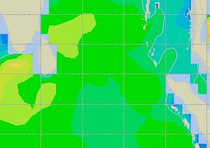
8 SATELLITE VIEW OF BAY OF BENGAL 02/01/2019, 10:30 UTC MATSAT-IR Ref:


9 SATELLITE VIEW OF BAY OF BENGAL 02/01/2019, 10:30 MATSAT-VIS Ref:
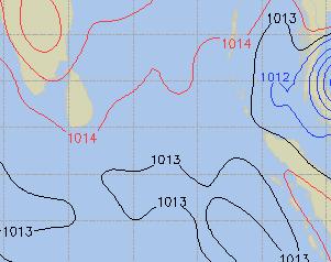
10 Part One NO STORM WARNING. Part Two SEASONAL LOW LIES OVER SOUTH BAY. Part Three Weather Wind Visibility TEMPORARY PARTLY CLOUDY OVER AREA C-90. WEST/NORTH-WESTERLY, KTS KMS. REDUCING TO 1000 METERS OR LESS IN FOG. Outlook MSL Pressure 12 HOURS LITTLE CHANGE. AT =02,0000 UTC. CHATTOGRAM = 1017HPA
11 , Inland River Port Warning THERE IS NO INLAND RIVERPORT WARNING AND NO SIGNAL IS TO BE HOISTED. Ref:


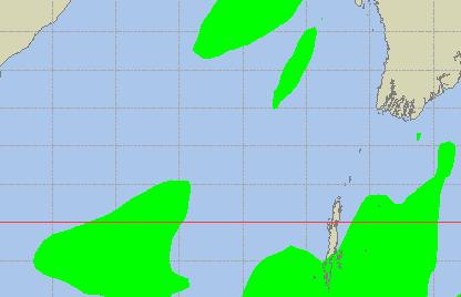
12 Legend: Calm Winds 5 Knots 10 Knots 60 Knots


13 04 Jan 19 Friday 05 Jan 19 Saturday Legend: Calm Winds 5 Knots 10 Knots 60 Knots


14 Sea State Ht (m) Over 14


15 04 Jan 19 Friday 05 Jan 19 Saturday


16 03 Jan 19 Thursday 04 Jan 19 Friday


17 03 Jan 19 Thursday 04 Jan 19 Friday

:")

18 03 Jan 19 Thursday 04 Jan 19 Friday Visibility Scale: Ref (Slide 12-18):
19 Rain (mm) 03 & 04 Jan 19 Rain (mm) 04 & 05 Jan 19 Precipitation Scale (mm):
20 Tidal Information 03 Jan Jan 19 KHAL NO. 10 COX S BAZAR HIRAN POINT Time Height Time Height Time Height Time Height Time Height Time Height Time Height Time Height Time Height 05 Jan
WEATHER FORECAST DHAKA
 WEATHER FORECAST DHAKA 05.09.2018 Hourly 2 PM 4 PM 8 PM 11 PM Temp. / Dew Point 33 / 25 32 / 25 29 / 24 28 / 25 Wind 18 km/h ESE 16 km/h SE 15 km/h SE 15 km/h ESE Humidity 64% 67% 78% 81% Chance of Precip
WEATHER FORECAST DHAKA
 WEATHER FORECAST DHAKA 02.07.2018 Hourly 2 PM 4 PM 8 PM 11 PM Temp. / Dew Point 32 / 26 31 / 26 28 / 25 28 / 25 Wind 13 km/h S 12 km/h S 15 km/h S 12 km/h S Humidity 74% 77% 83% 84% Chance of Precip 73%
WEATHER FORECAST DHAKA
 WEATHER FORECAST DHAKA 21.10.2017 Hourly 1 PM 4 PM 8 PM 11 PM Temp. / Dew Point 26 / 24 26 / 23 26 / 22 26 / 22 Wind 20 km/h S 29 km/h SSW 17 km/h SW 13 km/h WSW Humidity 91% 86% 79% 78% Chance of Precip
WEATHER FORECAST DHAKA
 WEATHER FORECAST DHAKA 06.09.2018 Hourly 2 PM 4 PM 8 PM 11 PM Temp. / Dew Point 32 / 24 30 / 24 28 / 24 28 / 25 Wind 27 km/h SE 27 km/h SE 24 km/h SE 21 km/h SE Humidity 63% 68% 78% 80% Chance of Precip
Issued by: National Weather Service San Joaquin Valley - Hanford CA. Issue time: 409 AM PST Wed Jan
 Forecast Information Location: New_Exchequer_Dam Updated: January 16, 2019, 11:45 am NWS Weather Discussion: Issued by: National Weather Service San Joaquin Valley - Hanford CA Issue time: 409 AM PST Wed
Forecast for 6/28-7/31. Forecaster: Matthew Brewer Forecast made at: 12z 6/27/2017
 Forecast for 6/28-7/31 Forecaster: Matthew Brewer Forecast made at: 12z 6/27/2017 Whiteface lodge Mesonet Meteogram for the past 24 hours http://www.nysmesonet.org/data/meteogram#?stid=wfmb Whiteface Summit
LOCAL CLIMATOLOGICAL DATA Monthly Summary November 2006
 Deg. Days Precip Ty Precip Wind Sun Hu- Adj. to Sea Level mid- ity Avg Res Res Peak Minute 1 fog 2 hvy fog 3 thunder 4 ice plt 5 hail 6 glaze 7 duststm 8 smk, hz 9 blw snw 1 2 3 4A 4B 5 6 7 8 9 12 14 15
Weather Practice. 4. As wind velocity decreases, the distance between isobars on a weather map will A) decrease B) increase C) remain the same
 decrease B) increase C) remain the same") 1. The chart below shows the air temperature and the dewpoint temperature near the ground at a given location for four consecutive days. All temperatures were recorded at noon. Which statement is best
1. The chart below shows the air temperature and the dewpoint temperature near the ground at a given location for four consecutive days. All temperatures were recorded at noon. Which statement is best
LOCAL CLIMATOLOGICAL DATA Monthly Summary July 2013
 Deg. Days Precip Ty Precip Wind Solar Hu- Adj. to Sea Level mid- ity Avg Res Res Peak Minute 1 fog 2 hvy fog 3 thunder 4 ice plt 5 hail 6 glaze 7 duststm 8 smk, hz 9 blw snw 1 2 3 4A 4B 5 6 7 8 9 12 14
LOCAL CLIMATOLOGICAL DATA Monthly Summary September 2016
 Deg. Days Precip Ty Precip Wind Solar Hu- Adj. to Sea Level mid- ity Avg Res Res Peak 2 Minute 1 fog 2 hvy fog 3 thunder 4 ice plt 5 hail 6 glaze 7 duststm 8 smk, hz 9 blw snw 1 2 3 4A 4B 5 6 7 8 9 11
Vantage PRO2 Quick. Reference Guide
 Vantage PRO2 Quick Reference Guide INTRO This Quick Reference Guide will provide you with abbreviated instructions for all functions of the Vantage Pro2 console. For more detailed instructions, see Vantage
Average Weather For Coeur d'alene, Idaho, USA
 Average Weather For Coeur d'alene, Idaho, USA Information courtesy of weatherspark.com Location This report describes the typical weather at the Coeur d'alene Air Terminal (Coeur d'alene, Idaho, United
Lab 19.2 Synoptic Weather Maps
 Lab 19.2 Synoptic Weather Maps Name: Partner: Purpose The purpose of this lab is to have you read and interpret the information displayed on synoptic weather maps. You will also learn the techniques used
Quick Reference Guide
 Vantage PRO Davis Instruments 3465 Diablo Ave, Hayward, CA 94545 U.S.A. Phone (510) 732 9229 Fax (510) 732 9188 www.davisnet.com E-mail: sales@davisnet.com support@davisnet.com Quick Reference Guide Part
California OES Weather Threat Briefing
 California OES Weather Threat Briefing Wednesday, January 16, 2019 9:00 AM PST Day 1: Strong winds, heavy mountain snow and heavy rain with isolated thunderstorms across much of the state through Thursday
National Meteorological Center can be contacted at: / Mail address:
 National Meteorological Center can be contacted at: 597-6806599/ 597-325190 Mail address: infometeozan@publicworks.gov.sr WEATHER FOR SURINAME Valid from 07.00lt January 08 till 07.00lt January 09, 2018
MARINE WEATHER HINDCAST REPORT
 MARINE WEATHER HINDCAST REPORT PREPARED FOR US SAILING INVESTIGATIVE PANEL VESSEL : Aegean INCIDENT LOCATION : APPROX 32.45N 117.30W INCIDENT TIME : APPROX 1:30AM Apr. 28 2012 PREPARED BY SAM WILSON M.S.
Baton Rouge Climate Summary: July 2014
 Baton Rouge Climate Summary: July 2014 (based on available data as of 07 August 2014) July Weather Highlights: - 2014 s run of cooler-than-normal weather continues - three July cool fronts very uncommon
An upper to mid level circulation (Low) in the NW Caribbean is
 in the NW Caribbean is") WEEKLY WEATHER OUTLOOK BELIZE, CENTRAL AMERICA PERIOD: Monday-Monday, Oct. 1 October 8, 2012 DATE ISSUED: Monday, Oct 1, 2012 6:00 am RFrutos EcoSolutions & Services SYNOPSIS: An upper to mid level circulation
WEEKLY WEATHER OUTLOOK BELIZE, CENTRAL AMERICA PERIOD: Monday-Monday, Oct. 1 October 8, 2012 DATE ISSUED: Monday, Oct 1, 2012 6:00 am RFrutos EcoSolutions & Services SYNOPSIS: An upper to mid level circulation
4. Which map best represents the type of fronts and direction of movement of these fronts in relation to the low-pressure center?
 1. Adjacent water and landmasses are heated by the morning Sun on a clear, calm day. After a few hours, a surface wind develops. Which map best represents this wind's direction? 2. An air pressure of 29.47
Average Weather In March For Fukuoka, Japan
 Average Weather In March For Fukuoka, Japan Location This report describes the typical weather at the Fukuoka Airport (Fukuoka, Japan) weather station over the course of an average March. It is based on
Severe Weather Objectives
 Severe Weather Objectives Describe how lightning forms. Describe the formation of thunderstorms, tornadoes, and hurricanes. Describe the characteristics of thunderstorms, tornadoes, and hurricanes. Explain
Predicting Weather Conditions. Do you have a career as a meteorologist?
 Predicting Weather Conditions Do you have a career as a meteorologist? It is essential for students for know 1. Weather conditions and patterns can be based on weather data collected from various sources.
Introduction. Sunny Partly Cloudy Cloudy. Flurries Snow Ice. Showers Thunderstorms Rain. High Pressure Low Pressure FRONTS. Cold Warm Stationary
 Introduction Weather can change from minute to minute, hour to hour, day to day, or season to season. Meteorologists are scientists who study Earth s atmosphere in order to predict these changes. Meteorologists
WEEKLY WEATHER OUTLOOK BELIZE, CENTRAL AMERICA
 WEEKLY WEATHER OUTLOOK BELIZE, CENTRAL AMERICA PERIOD: Sunday, July 1 until Monday, July 9, 2012 DATE ISSUED: Sunday, July 1, 2012 3:00 pm RFrutos EcoSolutions & Services SYNOPSIS: The features of interest
'Day in the Life' Physical Data 10/18/11. RM : cm site tube. typical fall, sun, clouds, small rain mostly 1 South calm
 RM Site Time Time 24 hr clock Air Temp. C Air Temp. F RM 300 6:00 3.33 38 clear RM 200 10:07 12 52 cloudy RM 153 9:52 20 62 rain Weather Today Weather Last 3 days cool, slight rain, rain last night windy,
WEEKEND WEATHER OUTLOOK BELIZE, CENTRAL AMERICA
 WEEKEND WEATHER OUTLOOK BELIZE, CENTRAL AMERICA PERIOD: Friday, July 13 until Monday, July 16, 2012 DATE ISSUED: Friday, June 13, 2012, 9:00 am RFrutos SYNOPSIS: A weak pressure gradient over the NW Caribbean
Baton Rouge Climate Summary: February 2013
 Baton Rouge Climate Summary: February 2013 (based on available data as of 15 March 2013) February Weather Highlights: - another wet month to close the 2012-2013 winter - minor flooding along the Amite
Answers to Clicker Questions
 Answers to Clicker Questions Chapter 1 What component of the atmosphere is most important to weather? A. Nitrogen B. Oxygen C. Carbon dioxide D. Ozone E. Water What location would have the lowest surface
Coastal Storm this Weekend
 Weather Briefing Prepared 9 AM EST Feb 5, 2010 Joe Miketta Warning Coordination Meteorologist NOAA s National Weather Service Philadelphia/Mt. Holly NJ Forecast Office 609-261 261-6602 6602 x223 Joseph.Miketta@noaa.gov
Chapter 2 Weather Patterns Guided Notes Objective(s): 7.E.1.4 Predict weather conditions and patterns based on information obtained from:
: 7.E.1.4 Predict weather conditions and patterns based on information obtained from:") Chapter 2 Weather Patterns Guided Notes Objective(s): 7.E.1.4 Predict weather conditions and patterns based on information obtained from: Weather data collected from direct observations and measurement
Chapter 2 Weather Patterns Guided Notes Objective(s): 7.E.1.4 Predict weather conditions and patterns based on information obtained from: Weather data collected from direct observations and measurement
February 2011: A Month of Below Average Temperatures, A Record Cold Snap, and a Sharp Frontal Passage with Snow
 1 Steven Mullen February 2011: A Month of Below Average Temperatures, A Record Cold Snap, and a Sharp Frontal Passage with Snow Overview of the Weather and Detail Diagnosis for Feb 25 th -27 th Daily surface
CW3E Atmosphere River Update - Summary
 CW3E Atmosphere River Update - Summary Two Atmospheric Rivers (ARs) made landfall over the Pacific Northwest over the previous four days These events combined to produce >400 mm of precipitation in southern
ARUBA CLIMATOLOGICAL SUMMARY 2014 PRECIPITATION
 ARUBA CLIMATOLOGICAL SUMMARY 2014 PRECIPITATION The total amount of rainfall recorded at Reina Beatrix International Airport for the year 2014 was 309.2 mm. This is 34.4 % below normal ( Figure 1 ). During
CropCast Corn and Soybean Report Kenny Miller Tuesday, March 14, 2017
 Accumulated Rainfall (inches) Accumulated GDDs Temperature ( F)/Wind Speed (mph) Precipitation (inches) CropCast Corn and Soybean Report Kenny Miller Tuesday, March 14, 2017 Peoria, IL Regional Forecast
ESCI 1010 Lab 6 Midlatitude Cyclones and Thunderstorms
 ESCI 1010 Lab 6 Midlatitude Cyclones and Thunderstorms Before Lab: Review pages 244-324 in your Weather and Climate textbook. Pay special attention to the sections entitled Fronts, Life Cyclone of a Midlatitude
NOAA s National Weather Service Philadelphia/Mt. Holly NJ
 Next Briefing Package: Friday, October 2, 2015 no later than 300 PM Hazards and Impacts: Overview: A dangerous weather pattern still threatens our region. Threats include very heavy rainfall, inland river
2016 EXPLANATION OF OBSERVATIONS BY REFERENCE NUMBER
 S 2016 EXPLANATION OF OBSERVATIONS BY REFERENCE NUMBER tation was moved to 10905 Virginia Forest Court Glen Allen, Virginia in Henrico County on June 10, 2008. Latitude 37 39' 18.87" (37.65537) Longitude
Baton Rouge Climate Summary: June 2012
 Baton Rouge Climate Summary: June 2012 (based on available preliminary data as of 30 July 2012) June 2012 s average temperature was 81.8 F, 0.7 above the monthly norm. While the June temperature departure
TROPICAL DEPRESSION HARVEY BRIEFING
 TROPICAL DEPRESSION HARVEY BRIEFING 10:15 PM CDT Wednesday, August 23, 2017 Prepared by: Lara Beal NWSCorpus www.weather.gov/corpuschristi Situation Overview No changes to Watches. Hurricane Watch remains
Weather An Introduction to Weather
 Non-fiction: Weather An Introduction To Weather Weather An Introduction to Weather Monday Tuesday Wednesday Thursday Friday What does the word weather mean to you? Everyone knows how to describe the weather.
SOFTWARE USER MANUAL. Weather Capture Advance WS1640 WM9280
 SOFTWARE USER MANUAL Weather Capture Advance WS1640 WM9280 1 TABLE OF CONTENTS 1. Introduction 3 1.1 System requirements 1.2 Connection of the weather station 1.3 Installation of the Weather Capture Advance
Name Period 4 th Six Weeks Notes 2013 Weather
 Name Period 4 th Six Weeks Notes 2013 Weather Radiation Convection Currents Winds Jet Streams Energy from the Sun reaches Earth as electromagnetic waves This energy fuels all life on Earth including the
Remote Sensing Observations AOSC 200 Tim Canty
 Remote Sensing Observations AOSC 200 Tim Canty Class Web Site: http://www.atmos.umd.edu/~tcanty/aosc200 Topics for today: Maps Radar Satellite Observations Lecture 04 Feb 7 2019 1 Today s Weather Map http://www.wpc.ncep.noaa.gov/sfc/namussfcwbg.gif
Name 28-MAY-08. FA RP 1 Mr. Chase. 1. Which weather-station model shows an air pressure of millibars?
 FA RP 1 Mr. Chase Name 28-MAY-08 1. Which weather-station model shows an air pressure of 993.4 millibars? 2. Which station model shows the correct form for indicating a northwest wind at 25 knots and an
Fun with Weather Maps! (no, really stop laughing) AOSC 200 Tim Canty
 AOSC 200 Tim Canty") Fun with Weather Maps! (no, really stop laughing) AOSC 200 Tim Canty Class Web Site: http://www.atmos.umd.edu/~tcanty/aosc200 Topics for today: Observations Station Model Temperature Maps Pressure Maps
Fun with Weather Maps! (no, really stop laughing) AOSC 200 Tim Canty Class Web Site: http://www.atmos.umd.edu/~tcanty/aosc200 Topics for today: Observations Station Model Temperature Maps Pressure Maps
APPENDIX G-7 METEROLOGICAL DATA
 APPENDIX G-7 METEROLOGICAL DATA METEOROLOGICAL DATA FOR AIR AND NOISE SAMPLING DAYS AT MMR Monthly Normals and Extremes for Honolulu International Airport Table G7-1 MMR RAWS Station Hourly Data Tables
Weather. Describing Weather
 Weather Describing Weather What is weather? Weather is the atmospheric conditions, along with short-term changes, of a certain place at a certain time. Have you ever been caught in a rainstorm on what
DEPARTMENT OF GEOSCIENCES SAN FRANCISCO STATE UNIVERSITY. Metr Fall 2012 Test #1 200 pts. Part I. Surface Chart Interpretation.
 DEPARTMENT OF GEOSCIENCES SAN FRANCISCO STATE UNIVERSITY NAME Metr 356.01 Fall 2012 Test #1 200 pts Part I. Surface Chart Interpretation. Figure 1. Surface Chart for 1500Z 7 September 2007 1 1. Pressure
Tropical Revolving Storm (TRS)
") Tropical Revolving Storm (TRS) Tropical revolving storm (TRS) is a warm-core, low-pressure system, around which the air circulation is anti-clockwise, in the Northern Hemisphere (NH) and clockwise, in
Tropical Revolving Storm (TRS) Tropical revolving storm (TRS) is a warm-core, low-pressure system, around which the air circulation is anti-clockwise, in the Northern Hemisphere (NH) and clockwise, in
A surge in the easterlies and an influx of moisture and instability is inducing
 WEEKLY WEATHER OUTLOOK BELIZE, CENTRAL AMERICA PERIOD: Monday-Monday, July 16-23, 2012 DATE ISSUED: Monday, July 16, 2012 6:00 am RFrutos EcoSolutions & Services SYNOPSIS: A number of features of interest
MOISTURE IN THE ATMOSPHERE MEGA PACKET
 NAME: MEGA PACKET 1. A psychrometer is used to determine which weather variables? A) wind speed and wind direction B) percentage of cloud cover and cloud height C) air pressure and air temperature D) relative
DEPARTMENT OF EARTH & CLIMATE SCIENCES SAN FRANCISCO STATE UNIVERSITY. Metr Fall 2014 Test #1 September 30, 2014
 DEPARTMENT OF EARTH & CLIMATE SCIENCES SAN FRANCISCO STATE UNIVERSITY NAME Metr 302.02 Fall 2014 Test #1 September 30, 2014 200 pts (4 pts each answer) Part I. Surface Chart Interpretation. Questions 1
4thscience_earth (4thscience_earth)
") Name: Date: 1. The temperature at noon for the last week is shown in the graph. Which day had a lower temperature than Tuesday? A. Monday B. Wednesday C. Thursday D. Saturday 2. Which instrument would
Name: Date: 1. The temperature at noon for the last week is shown in the graph. Which day had a lower temperature than Tuesday? A. Monday B. Wednesday C. Thursday D. Saturday 2. Which instrument would
AMDAR Forecast Applications. Richard Mamrosh NWS Green Bay, Wisconsin, USA
 AMDAR Forecast Applications Richard Mamrosh NWS Green Bay, Wisconsin, USA AMDAR has many applications Aviation Low level wind shear Ceilings and visibilities Icing and turbulence Winter Storms Precipitation
Marshall Alexander Forecaster Commonwealth of Dominica
 Marshall Alexander Forecaster Commonwealth of Dominica Dominica 2015 Impacts Tropical Storm Danny (August 24 th ) Tropical Storm Erika (August 27 th ) Tropical Storm Grace (Remnants) (September 10 th -11
NOAA s National Weather Service Philadelphia/Mt. Holly NJ
 Next Briefing Package: Thursday, October 1, 2015 no later than 300 PM Hazards and Impacts: Overview: A dangerous weather pattern is developing for our region. Threats include very heavy rainfall, inland
CropCast Corn and Soybean Report Kenny Miller Friday, March 17, 2017
 Accumulated Rainfall (inches) Accumulated GDDs Temperature ( F)/Wind Speed (mph) Precipitation (inches) CropCast Corn and Soybean Report Kenny Miller Friday, March 17, 2017 Peoria, IL Regional Forecast
Deliverable 4-2: Assessment items. Activity-oriented Quiz for Weather or Not? Investigation in Exploring the Environment
 Deliverable 4-2: Assessment items Activity-oriented Quiz for Weather or Not? Investigation in Exploring the Environment In Weather or Not? you predicted the weather using satellite images and other kinds
Temperature, Observations, and Maps AOSC 200 Tim Canty. Weather and Climate
 Temperature, Observations, and Maps AOSC 200 Tim Canty Class Web Site: http://www.atmos.umd.edu/~tcanty/aosc200 Topics for today: Climate Weather Observations Weather Maps Lecture 03 Feb 5 2019 1 Weather
Sources of Hourly Surface Data and Weather Maps for the U.S.
 Sources of Hourly Surface Data and Weather Maps for the U.S. Weather Underground Weather Underground http://www.wunderground.com/history/ maintains a deep archive of hourly reports for around the world.
WM9280. Pro Family weather station with T/H sensor, pluviometer, anemometer, PC connection and Meteotime weather forecasts until 3 days
 Technical sheet Pro Family weather station with T/H sensor, pluviometer, anemometer, PC connection and Meteotime weather forecasts until 3 days RADIO-CONTROLLED TIME AND DATE - WEATHER FORECASTS FOR CURRENT
Maps and Remote Sensing AOSC 200 Tim Canty
 Maps and Remote Sensing AOSC 200 Tim Canty Class Web Site: http://www.atmos.umd.edu/~tcanty/aosc200 Topics for today: Weather Maps Radar Satellite Observations Lecture 04 Feb 7 2019 1 Today s Weather Map
The Causes of Weather
 Meteorology The Causes of Weather Where does the weather in our country come from? * Which air masses determine the weather in our country? * Weather or Climate? *The current state of the atmosphere *
Guide to Understanding the Forecast
 Guide to Understanding the Forecast The Antigua and Barbuda Meteorological Service (ABMS) issues forecasts for sky condition, precipitation probability, precipitation accumulation, wind, seas and temperature.
CW3E Atmospheric River Update Outlook Strong AR forecast to impact California this weekend - A strong AR with IVT as high as 1000 kg m -1 s -1 is
 CW3E Atmospheric River Update Outlook Strong AR forecast to impact California this weekend - A strong AR with IVT as high as 1000 kg m -1 s -1 is forecast make landfall over the West Coast this Weekend
A) B) C) D) 2) The diagrams below show the phases of the Moon as viewed by an observer in New York State at different times in August.
 B) C) D) 2) The diagrams below show the phases of the Moon as viewed by an observer in New York State at different times in August.") Name: 1) Which weather station model indicates the highest relative humidity? 8605-1 - Page 1 A) B) C) D) 2) The diagrams below show the phases of the Moon as viewed by an observer in New York State at
Name: 1) Which weather station model indicates the highest relative humidity? 8605-1 - Page 1 A) B) C) D) 2) The diagrams below show the phases of the Moon as viewed by an observer in New York State at
(1) a hurricane warning (2) a gale warning (3) a storm watch (4) a storm warning (5) a hurricane watch
 a hurricane warning (2) a gale warning (3) a storm watch (4) a storm warning (5) a hurricane watch") Instructor: Prof. Seiberling PHYSICS DEPARTMENT MET 1010 Final Exam December 15, 2003 Name (print, last rst): Signature: On my honor, I have neither given nor received unauthorized aid on this examination.
Instructor: Prof. Seiberling PHYSICS DEPARTMENT MET 1010 Final Exam December 15, 2003 Name (print, last rst): Signature: On my honor, I have neither given nor received unauthorized aid on this examination.
CropCast Corn and Soybean Report Kenny Miller Monday, March 13, 2017
 Accumulated Rainfall (inches) Accumulated GDDs Temperature ( F)/Wind Speed (mph) Precipitation (inches) CropCast Corn and Soybean Report Kenny Miller Monday, March 13, 2017 Peoria, IL Regional Forecast
WEEKLY WEATHER OUTLOOK BELIZE, CENTRAL AMERICA
 WEEKLY WEATHER OUTLOOK BELIZE, CENTRAL AMERICA PERIOD: Sunday, June 17 until Monday, June 25, 2012 DATE ISSUED: Sunday, June 17, 2012; 3:00 pm RFrutos EcoSolutions & Services SYNOPSIS: An upper level trough
APanel Documentation
 APanel Documentation First released: Jul 0, 008; Last modified: Aug 16, 009 Introduction APanel (Astroweather Panel) is a numerical weather product which is especially designed for astronomical purpose.
Tuesday, September 13, 16
 Weather Weather State Objectives 4.c, 4.d, 4.h. Discussion What are some ways in which weather affects your everyday life? Discussion What are some ways in which weather affects your everyday life? What
Questions. Making Better Weather-Based Management Decisions. Dual Polarization 5/1/2018
 Making Better Weather-Based Management Decisions Brad Jakubowski, brj8@psu.edu Questions Should I irrigate? Should I be scouting for diseases? Can I spray today? Should I syringe? Should we start later
MAST ACADEMY OUTREACH. WOW (Weather on Wheels)
") MAST ACADEMY OUTREACH ELEMENTARY SCHOOL PROGRAM Adventures Aboard WOW (Weather on Wheels) On-Site Packet MAST Academy Maritime and Science Technology High School Miami-Dade County Public Schools Miami,
MAST ACADEMY OUTREACH ELEMENTARY SCHOOL PROGRAM Adventures Aboard WOW (Weather on Wheels) On-Site Packet MAST Academy Maritime and Science Technology High School Miami-Dade County Public Schools Miami,
National Maritime Center
 National Maritime Center Providing Credentials to Mariners (Sample Examination) Page 1 of 5 Choose the best answer to the following Multiple Choice Questions. 1. Fog is formed when which condition exists?
Introduction to Numerical Weather Prediction. Mike Leuthold Atmo 336
 Introduction to Numerical Weather Prediction Mike Leuthold Atmo 336 Model Components This flowchart, starting at the bottom, shows how the components of Numerical Weather Prediction (NWP) and how it fits
Subtropical Storm Ana
 Subtropical Storm Ana Threat Assessment for northeast South Carolina & southeast North Carolina Created 745 AM Fri May 8, 2015 Reid Hawkins, Science Officer National Weather Service Wilmington, NC 1 New
Chapter 5: Weather. Only Section 1: What is Weather?
 Chapter 5: Weather Only Section 1: What is Weather? Find the definitions of: Meteorology, meteorologist, weather, climate Not in book? Use the dictionaries **Meteorology - Meteorology is the study of the
Observing Weather: Making the Invisible Visible. Dr. Michael J. Passow
 Observing Weather: Making the Invisible Visible Dr. Michael J. Passow What Is Weather? Weather refers to the conditions of the atmosphere at a certain place and time. Weather differs from Climate, which
MxVision WeatherSentry Web Services Content Guide
 MxVision WeatherSentry Web Services Content Guide July 2014 DTN 11400 Rupp Drive Minneapolis, MN 55337 00.1.952.890.0609 This document and the software it describes are copyrighted with all rights reserved.
Major Hurricane Earl
 Major Hurricane Earl Advisory 33 North Carolina Threat Assessment Prepared at: 11 AM Thursday September 2, 2010 Hurricane and Tropical Storm Warnings in effect for the North Carolina Coast and Sounds NWS
CASE STUDY: Tropical Cyclone Monica, April 2006
 CASE STUDY: Tropical Cyclone Monica, April 2006 By Mr Jeff Callaghan Retired Senior Severe Weather Forecaster, Bureau of Meteorology, Brisbane The track of tropical cyclone Monica (Figure 1) took it from
DEPARTMENT OF EARTH & CLIMATE SCIENCES Name SAN FRANCISCO STATE UNIVERSITY Nov 29, ERTH 360 Test #2 200 pts
 DEPARTMENT OF EARTH & CLIMATE SCIENCES Name SAN FRANCISCO STATE UNIVERSITY Nov 29, 2018 ERTH 360 Test #2 200 pts Each question is worth 4 points. Indicate your BEST CHOICE for each question on the Scantron
Day in the Life of the Hudson River October 20, Physical Data. kilometers per second. Weather Last 3 days. % cloudcover. Wind MPH.
 10/20/2015 RM NAME Time 24 hr clock Air Temperature C Air Temp. F Weather Today Weather Last 3 days % cloudcover Mohawk Schoharie 9:00 10.5 sprinkles and 50.9 light rain 40s and some snow 50 1 calm, clear
Management in Surface, Climate and Upper-air Observations in RAII,Tokyo, Assistant Director Bangladesh Meteorological Department
 JMA / WMO Workshop on Quality Management in Surface, Climate and Upper-air Observations in RAII,Tokyo, 27-30 July 2010 Shamsuddin Ahmed Assistant Director Bangladesh Meteorological Department Bangladesh
Weather Maps. The Sun s radiation produces weather on Earth.
 Sunny days give way to rainy days. Storms appear, then fade away. Howling winds become gentle breezes. At one o clock on an autumn afternoon, an outdoor thermometer reads 20 C. An hour later, the temperature
Precip By Ant READ ONLINE
 Precip By Ant READ ONLINE If you are searched for a ebook Precip by Ant in pdf format, then you have come on to the right site. We present full variation of this book in PDF, txt, doc, DjVu, epub formats.
Coastal Storm. Wednesday through Friday, 3/6-8/2013 Weather Briefing
 Coastal Storm Wednesday through Friday, 3/6-8/2013 Weather Briefing Prepared 2:00 PM EST Wednesday, March 6, 2013 National Weather Service New York, NY Purpose of Briefing Promote Situational Awareness
Page 1. Name:
 Name: 1) As the difference between the dewpoint temperature and the air temperature decreases, the probability of precipitation increases remains the same decreases 2) Which statement best explains why
Jan 7, 2017 Winter Weather Event
 Jan 7, 2017 Winter Weather Event Decision Support Briefing # 5 Assessment for northeast South Carolina & southeast North Carolina National Weather Service Wilmington NC 4 PM EST Friday January 6, 2017
Natural Event Documentation
 ADDENDUM Natural Event Documentation Corcoran, Oildale and Bakersfield, California September 22, 2006 San Joaquin Valley Unified Air Pollution Control District May 23, 2007 Natural Event Documentation
Tropical Storm Ana. Created 6:00 AM Sun May 10, 2015 John Cole Warning Coordination Meteorologist
 Tropical Storm Ana Threat Assessment for Eastern North Carolina Created 6:00 AM Sun May 10, 2015 John Cole Warning Coordination Meteorologist John.cole@noaa.gov National Weather Service Newport/Morehead
Hurricane Harvey: SE Texas Impacts. 10 AM CDT UPDATE Saturday, August 26, 2017 Prepared by: Dan Reilly, Brian Kyle
 Hurricane Harvey: SE Texas Impacts 10 AM CDT UPDATE Saturday, August 26, 2017 Prepared by: Dan Reilly, Brian Kyle Latest Observations and Radar Hurricane Harvey centered near Victoria and weakening Wind
Homework 2: Hurricane Katrina. Part 1. Hurricane Katrina, August 28, 2005 Satellite Imagery
 Metr 302 Homework 2 Fall 2014 Meteorology 302 Fall 2014 Name Homework 2: Hurricane Katrina 100 points total Distributed Thursday 30 October 2014; Due Thursday 13 November 2014 Answer all questions in complete
latent heat/humidity
 1. Base your answer(s) to the following question(s) on the Earth Science Reference Tables, the graph below, and your knowledge of Earth science. The graph shows variations in air temperature and relative
TROPICAL STORM HARVEY BRIEFING
 TROPICAL STORM HARVEY BRIEFING 1 PM CDT Saturday, August 26, 2017 Prepared by: John Metz NWSCorpus www.weather.gov/corpuschristi Overview Life-threatening conditions continue. Storm Surge Warnings remain
CropCast Corn and Soybean Report Kyle Tapley Monday, March 20, 2017
 Accumulated Rainfall (inches) Accumulated GDDs Temperature ( F)/Wind Speed (mph) Precipitation (inches) CropCast Corn and Soybean Report Kyle Tapley Monday, March 20, 2017 Peoria, IL Regional Forecast
Country Report: Bangladesh
 The 5th International Coordination Group (ICG) Meeting GEOSS Asian Water Cycle Initiative (AWCI) Tokyo, Japan, 15-18, December 2009 Country Report: Bangladesh Monitoring and forecasting of cyclones SIDR
4 Forecasting Weather
 CHAPTER 2 4 Forecasting Weather SECTION Understanding Weather BEFORE YOU READ After you read this section, you should be able to answer these questions: What instruments are used to forecast weather? How
MAST ACADEMY OUTREACH. WOW (Weather on Wheels)
") MAST ACADEMY OUTREACH MIDDLE SCHOOL PROGRAM Adventures Aboard WOW (Weather on Wheels) On-Site Packet MAST Academy Maritime and Science Technology High School Miami-Dade County Public Schools Miami, Florida
MAST ACADEMY OUTREACH MIDDLE SCHOOL PROGRAM Adventures Aboard WOW (Weather on Wheels) On-Site Packet MAST Academy Maritime and Science Technology High School Miami-Dade County Public Schools Miami, Florida