Country Report: Bangladesh
|
|
|
- Esmond Goodwin
- 5 years ago
- Views:
Transcription

1 The 5th International Coordination Group (ICG) Meeting GEOSS Asian Water Cycle Initiative (AWCI) Tokyo, Japan, 15-18, December 2009 Country Report: Bangladesh Monitoring and forecasting of cyclones SIDR and AILA Colonel Mohammad Ashfakul Islam Engineer Adviser Ministry of Defence Government of the People s Republic of Bangladesh Dhaka, Bangladesh
2 Introduction Bangladesh is a deltaic land of about 144,000 sq. km area having great Himalayas to the north and the vast Bay of Bengal on the south. It is a South Asian country extending from 20 45' N to 26 40' N and from 88 05' E to 92 40' E belonging to the South Asian Association for Regional Cooperation (SAARC). It has a complex coast line of about 710 kms and long continental shelf with shallow bathymetry. The Bay of Bengal forms a funneling shape towards the Meghna estuary and for that the storm surge is the highest here in the world. Bangladesh Meteorological Department (BMD) is the national meteorological service in Bangladesh under the Ministry of Defence of the Government of the People s Republic of Bangladesh is mandated for cyclone forecasting. Cyclone Preparedness Programme (CPP) under Bangladesh Red Crescent Society (BDRCS) forwards cyclone warning bulletins to 42,675 coastal volunteers for saving coastal vulnerable people.

3 Position of Bangladesh in the World Map and in the Asia Map Bangladesh


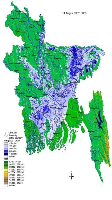
4 Topography of Bangladesh Land elevation of 50% of the country is within 5 m of MSL - About 68% of the country is vulnerable to flood % of the area is inundated during normal flood

5 Bangladesh is the most disaster prone area in the world. Most of these disasters are meteorological and hydrological in nature. Such as- Cyclone & associated Storm Surge Nor westers/tornadoes Drought Floods and River Erosion Heat Waves and Cold Waves Earthquakes Land slide

6 Some Catastrophic Cyclone that affected Bangladesh The great Bakerganj Cyclone of 1876 The worst killer Cyclone of November 1970 The Urrirchar Cyclone of May 1985 The Severe Cyclone of November 1988 The killer cyclone of April 1991 The Severe cyclone of May 1997 The Severe Cyclone of September 1997

7 Jan Feb Mar Apr May Jun Jul Aug Sep Oct Nov Dec Monthly distribution of Severe Cyclonic Storm (SCS) formed in the Bay of Bengal during
8 Decadal variation of SCS formed in the Bay of Bengal during

9 Bhola cyclone Track, 1970 April 29, 1991 Track Bhola Cyclone, 1970 Formed: November 7, 1970 Dissipated: November 13, 1970 Highest Winds (10 min sustained):185 KPH Highest winds (1 min sustained): 222 KPH Lowest Pressure: 966 hpa Fatalities: 300, ,000 Damage: 86.4 Million USD Affected areas: India & East Pakistan Bangladesh Cyclone, 1991 Formed: April 22, 1991 Dissipated: April 30, 1991 Highest winds (1 min sustained): 225 KPH Lowest Pressure: 898 hpa Fatalities: 138, 000 Damage: 1.5 billion USD Affected areas: Bangladesh Historical cyclones with high causalities
10 Cyclone Name Date of Formation Recent Cyclones Area of Formation Area of land fall Date of land fall Cyclone SIDR at 12 Noon SE Bay and adjoining area Khulna-Barisal coast (near Baleshwar river) at Evening Cyclone Nargis at 06 PM SE Bay and Adjoining SW Bay Southern coast of Myanmar (near Bassein) atafternoon Cyclone Rashmi at 06 PM WC Bay and Adjoining NE Bay Khulna-Barisal coast (near Patharghata) Morning Cyclone Bijli at 06 PM SE Bay and adjoining Central Bay Chittagong Cox s Bazar coast (near Chittagong) at 03 PM Cyclone Aila at 03 PM WC Bay and adjoining area West Bengal- Khulna coast (near Sagar Island) afternoon to evening
11 Cyclone Warning Systems in Bangladesh BMD is responsible for providing tropical cyclone warnings. Warnings and forecasts are issued under the authority of the Director, BMD. The tropical storm warnings are provided from the Storm Warning Centre (SWC) of BMD which is located at Dhaka. The tropical cyclones are tracked with the help of conventional observations, radar and satellite observations and model derived products. After issuing the tropical cyclone warnings are provided to: The Hon ble President The Hon ble Prime Minister Control room, Ministry of Food and Disaster Management (MoFDM) All ministries Sea Port Authorities at Chittagong, Mongla and Cox s Bazar Cyclone Preparedness Programme (CPP), Bangladesh Red Crescent Society Armed Forces division, Bangladesh Navy, Bangladesh Air Force Inland river ports authorities, Airport authorities Concerned government officials The general public (through Betar (Radio) Television, electronic media and mass-media) Fishing boats and trawlers in the sea, Coast Guard Non-Government Organizations
12 Stages of warnings Warnings are issued in four stages for the government officials. The first stage called "Alert" is issued to all concerned whenever a disturbance is detected in the Bay as per SOD of Bangladesh. In the second stage, cyclone warnings are issued in four steps as detailed below: a. Distant Cautionary Signal is issued if a ship might run into danger during its voyage after leaving the harbour. Distant Warning Signal issued when there is no immediate danger of the port but a ship might run into the storm after leaving the port. b. Local Cautionary Signal is issued when the port is threatened by squally weather from tropical disturbances. c. Local Warning Signal is issued when the port is threatened by a storm, but it does not appear that the danger is as yet sufficiently great to justify extreme measures of precaution. It is issued minimum 24 hours before the landfall. d. Danger Signal is issued when the port is likely to experience severe weather from a storm of slight or moderate intensity. The Signal is issued minimum 18 hours before the landfall. e. Great Danger Signal is issued when the port is likely to experience severe weather from a storm of great intensity. The signal is issued minimum 10 hours before the landfall.
13 Format of the cyclone warning bulletin Cyclone forecast or warnings are issued as header of Special Weather Bulletin. The bulletin contains the following information: Name of the storm Position of the storm centre Direction and speed of movement in knots (international use) and km/h (national use). Distance of the storm centre from the ports. Maximum sustained wind within the radius of maximum wind. Signals for the maritime ports. Areas are likely to be affected specifying Upazila (subdivision) as far as possible. Approximate time of commencement of gale winds (speed more than 51 km/ h). Storm surge height in meter and areas likely to be inundated. Advisory for fishing boats and trawlers over North Bay and Deep Sea.
14 Dissemination of cyclone bulletin Warnings are disseminated through high priority landline telegrams, telefax, telephone, teleprinter and e- mail. In addition, warnings are also transmitted to Betar (Radio) Bangladesh, Dhaka, Chittagong, Khulna, Rangpur, Rajshahi and Sylhet for broadcast. Alert messages are broadcast four to five times a day. "Warnings" are broadcast every hour and "Danger" and "Great Danger" messages are broadcast frequently. Warnings are made available in the BMD web page immediately after issuing from SWC.
15 Some hazardous scenario in Bangladesh


16 Heat wave Flood River Erosion Disasters in Bangladesh Cyclone Cold wave Thunderstorm


17 Manmade Disasters Land Slide Deforestation Blockage Drain Deforestation


18 Environmental Degradation Due to Climate Change Drainage congestion Mangrove forest under threat Typical erosion in small and medium rivers


19 Flood Situation: Bangladesh

20 Drought Condition: Bangladesh Pre-Kharif Drought Map: 2nd decade of March- 1st decade of June Kharif Drought Map: 2nd decade of Juneend of October Rabi Drought Map: 1st decade November-1st decade of March
21 Monitoring cyclone SIDR
22 Date & Time (UTC) Severe Cyclonic Storm (H) SIDR during November 2007 Position Status Signal for maritime ports Distance 10, 0000 South Andaman Sea Low , 1200 SE Bay WML DC-I , 0600 SE Bay (9.5 0 N & E) 12, 0000 SE Bay ( N & E) 12, 0600 SE Bay ( N & E) 13, 0300 SE Bay ( N & E) 14, 1200 SE Bay ( N & E) 15, 1500 Centre of the Cyclone crossed the coast 15, 2100 SIDR completed crossing the coast Depression DC-I Chittagong-1415 Cox s Bazar-1325 Mongla-1450 Deep Depression DC-I Chittagong-1360 Cox s Bazar-1270 Mongla-1385 CS SIDR DW-II Chittagong-1310 Cox s Bazar-1220 Mongla-1325 SCSH SIDR LW-IV Chittagong-1115 Cox s Bazar-1030 Mongla-1090 SCSH SIDR Mongla port-x, Chittagong-IX Cox s Bazar-IX Chittagong-755 Cox s Bazar-675 Mongla-705 SCSH SIDR do SCSH SIDR do

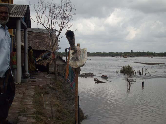
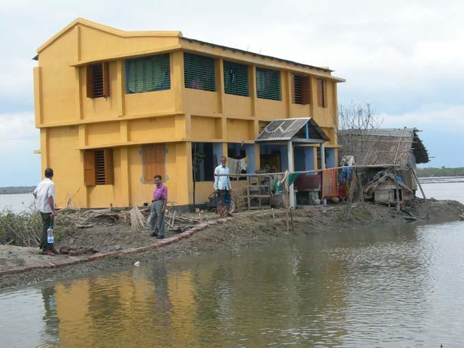
23 Cyclone SIDR Storm surge flooding Out of 30 affected districts 15 were worst affected 1. Total Death 3, People missed Family affected 1,928, People affected 8,545, Houses damaged 1,449, Crop damaged 2,077, Trees destroyed 4,065,316


24 Storm surge


25


26

27


28

29 MTSAT IR1 Image animation of Severe Cyclonic Storm SIDR crossed Bangladesh BMD Radar Image animation of Severe Cyclonic Storm SIDR crossed Bangladesh

 but after 1200 UTC of 14 November its movement increased very rapidly towards north (Bangladesh coast) and reached")
30 Intensity and movement of cyclone SIDR The intensity of cyclone SIDR increased rapidly upto its cyclonic stage after its formation when it was in deep sea and then increased slowly by maintaining its energy and reached maximum state when it was little away from the coast of Bangladesh. But after making landfall it was loosing its energy rapidly by giving high wind in the coastal belt of Bangladesh (shown in Fig. 3). It is found that the movement of the cyclone SIDR was low (~ 5 knots) but after 1200 UTC of 14 November its movement increased very rapidly towards north (Bangladesh coast) and reached as high as about 30 knots (shown in Fig. 4). Fig. 3: Variation of intensity of cyclone SIDR Fig. 4: Variation of horizontal SIDR speed
 and is given in Fig.")
31 Recorded rainfall due to cyclone SIDR The higher rainfall were recorded in the areas of passage of cyclone SIDR but the amounts of rainfall were low compared with the previous cyclones crossed Bangladesh coast. This may be due to higher intensity of SIDR. The weak cloud band was also observed from the Cox s Bazar Radar (located at N and long E) and is given in Fig. 5. Fig. 5: Radar image of cyclone SIDR
 and Srimongal (lat. 24.3 N and long. 91.73 E) respectively. The distribution of rainfall associated with SIDR is given in Fig. 6. Fig. 6: Spatial distribution of cyclone SIDR related rainfall")
32 Recorded rainfall due to cyclone SIDR The highest rainfall of 144 mm is recorded at Sylhet (lat N and long E) 143 mm at Chittagong (lat N and long E), Hatiya (lat N and long E) and Srimongal (lat N and long E) respectively. The distribution of rainfall associated with SIDR is given in Fig. 6. Fig. 6: Spatial distribution of cyclone SIDR related rainfall
33 Recorded wind due to cyclone SIDR The higher wind was recorded in the southwestern part of Bangladesh where SIDR made its landfall and followed by the right side of SIDR in the southern coastal districts of Bangladesh (shown in Fig. 7). The highest maximum wind of 223 km/hr is recorded at Patuakhali (lat N and long E). Though SIDR made its landfall in the eastern side of Sundarban (a large forest) but the passage of it was long over the central flat land and its associated wind speed was higher as a result it had a good wind impact on Bangladesh. This behaviour was not observed in earlier cases. Fig. 7: Spatial distribution of cyclone SIDR related wind

34 Storm surge related to cyclone SIDR When SIDR was approaching towards Bangladesh coast, its intensity was becoming higher and higher. Accordingly its associated storm surge should be higher compared to the previous cyclones crossed Bangladesh coast. But during the landfall there were low tide time over the North Bay and the adjoining rivers of Bangladesh. As a result recorded storm surge was lower (the maximum recorded storm surge about 18 ft) ( Fig. 8). Fig. 8: Variation of intensity of cyclone SIDR
35 Damage aspect of Cyclone SIDR BMD advised the concerned authorities about SIDR by issuing Great Danger Signals nearly 27 hours before its landfall. The lead time enabled the disaster mitigation agencies to control the loss of lives by providing shelters to the people at risk in the coastal areas. BMD issued timely and accurate warnings and disseminated them to the concerned authorities to handle the SIDR situation efficiently. Hence the loss of lives and damage to properties were less than the past. Brief damage list of cyclone SIDR Total Death: 3363 People missed: 871 Family affected: 1,928,265 People affected: 8,545,470 Houses damaged: 1,449,157 Crop damaged: 2,007,226 Trees destroyed: 4,065,316 Total damage cost: about 450 million USD
36 Method of disaster management aspect related to cyclone SIDR On 13 November, when the System turned into a SCS (H) maritime ports were advised to hoist Warning Signal Number Four and all fishing boats and trawlers over North Bay were advised to take shelter immediately. A meeting of NDMC was held immediately after hoisting Signal Number Four. In that meeting all the concerned authorities were instructed to take the necessary steps according to SOD The Armed Forces Division (AFD) and government officials were also placed on standby. Several central control rooms were activated by various agencies at national, district and upazila levels while the DMIC was opened. A series of meetings and arrangements were in place to quickly mobilize staff and resources. At 9 PM on 14 November 2007, SIDR was centered about 725 km Southsouthwest of Chittagong port, 645 km South-southwest of Cox s Bazar port and 670 km South of Mongla port.
37 Method of disaster management aspect related to cyclone SIDR continue. In this situation BMD advised the maritime port of Mongla to hoist Great Danger Signal Number Ten. BMD also included the coastal districts of Bhola, Barisal, Patuakhali, Barguna, Pirojpur, Jhalakhathi, Bagerhat, Khlna, Satkhira and their offshore islands and chars under Great Danger Signal Number Ten. The ports of Chittagong and Cox s Bazar were advised to hoist Great Danger Signal Number Nine and all other coastal districts were included under Great Danger Signal Number Nine. BMD predicted that SIDR would likely to cross Khulna-Barisal coast by afternoon of 15 November BMD estimated about SIDR s maximum wind about kph and associated storm surge of height feet above normal astronomical tide. Government as well as National and International NGOs mobilizes their staff and volunteers with a number of pre-positioning staff and relief materials closer to the forecasted impact areas.
38 Method of disaster management aspect related to cyclone SIDR continue. This action proved to be extremely beneficial given the access problems that arose later on in the post impact phase of the operation. Over 1.5m people were moved to shelters in the lead up to Cyclone SIDR with the help of Local Administration, CPP, Community leader & NGO workers. Some did not seek shelter because there were limited facilities for the cattle and livestock in the cyclone shelter. Cyclone SIDR hit offshore islands of Bangladesh at approximately hours on the evening of 15 November and made landfall across the Barisal-Patuakhali coast near Baleshwar river at 2100 BST during the low tide time. Wind speeds reached up to km per hour and affected 15 districts fully and 15 districts partly.
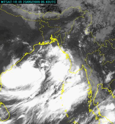
39 Monitoring cyclone AILA
40 Date & Time (UTC) 23, 0300 Southwest Bay and adjoining West Central Bay 23, 0900 West Central Bay and adjoining area Cyclonic Storm AILA during May , 0600 West Central adjoining East-Central Bay Position Status Signal for maritime ports Well Marked Low (WML) LC-III Advice The port is threatened by squally weather (wind speed of kms/hr) Depression LC-III Fishing boats and trawlers are advised to come close to the coast and proceed with caution and not to venture in to the deep Sea. Deep Depression LC-III do 24, 1200 West Central adjoining East-Central Bay Cyclonic Storm AILA LW-IV Fishing boats and trawlers are advised to remain in shelter. 24, 2100 North Bay and adjoining West Central Bay Cyclonic Storm AILA Mongla: DS-VII Chittagong: DS-V Cox s Bazar: DS-VI do 25, 0600 Near West Bengal (India) Khulna (Bangladesh coast) Cyclonic Storm AILA Mongla: DS-VII Chittagong: DS-V Cox s Bazar: DS-VI Do 25, 1200 Crossing West Bengal- Khulna (Bangladesh) coast near Sagar Island of India Cyclonic Storm AILA Mongla: DS-VII Chittagong: DS-V Cox s Bazar: DS-VI Do
 over Southwest Bay and")

41 : 09AM Situation: The low intensified into a Well Marked Low (WML) over Southwest Bay and adjoining West Central Bay Signals: Chittagong Port: LC-III Cox s Bazar Port: LC-III Mongla: LC-III Forecast: It is likely to intensify and move in a northwest/northerly direction. Local Cautionary Signal No. III Explanation: The port is threatened by squally weather (wind speed of kms/hour).


42 : 03PM: Special weather Bulletin SL.No.-1 Situation: The Well Marked Low over Southwest Bay and adjoining West Central Bay moved slightly northwards, intensified into a Depression over West Central Bay and adjoining area. Distance: Chittagong Port: 815 km Cox s Bazar Port: 745 km Mongla: 725 km Position Latitude: 16.0 N Longitude: 88.0 E Forecast: It is likely to intensify and move in a northwest/northerly direction.
43 : 03PM: Special weather Bulletin SL.No.-1 Continue Wind Condition: Maximum wind within 44 km radius of the Depression centre is about 40 Kph rising 50 Kph in gust/squalls. Sea Condition: Moderate around the Depression centre Signals: Chittagong Port: LC-III Cox s Bazar Port: LC-III Mongla: LC-III Local Cautionary Signal No. III Explanation: The port is threatened by squally weather (wind speed of kms/hour). Advice for fishing boats and trawlers: Come close to the coast and proceed with caution and not to venture in to the deep Sea.


44 : 12 Noon: Special weather Bulletin SL.No.-5 Situation: The Depression over West Central adjoining East-Central Bay moved slightly northwards, intensified into a Deep Depression over the same area. Distance: Chittagong Port: 610 km Cox s Bazar Port: 545 km Mongla: 515 km Position Latitude: 17.8 N Longitude: 88.6 E Forecast: It is likely to intensify and move in a north/northeasterly direction.
45 : 12 Noon: Special weather Bulletin SL.No.-5 Continue Wind Condition: Maximum wind within 48 km radius of the Depression centre is about 50 Kph rising 60 Kph in gust/squalls. Sea Condition: Rough around the Deep Depression centre. Signals: Chittagong Port: LC-III Cox s Bazar Port: LC-III Mongla: LC-III Local Cautionary Signal No. III Explanation: The port is threatened by squally weather (wind speed of kms/hour). Advice for fishing boats and trawlers: Come close to the coast and proceed with caution and not to venture in to the deep Sea.


46 : 06PM: Special weather Bulletin SL.No.-7 Situation: The Deep Depression over West Central Bay and adjoining West Central Bay moved northwards, intensified into a Cyclonic Storm Aila. Distance: Chittagong Port: 565 km Cox s Bazar Port: 510 km Mongla: 460 km Position Latitude: 18.3 N Longitude: 88.6 E Forecast: It is likely to intensify and move in a northerly direction.
47 : 06PM: Special weather Bulletin SL.No.-7 Continue Wind Condition: Maximum wind within 54 km radius of the Depression centre is about 60 Kph rising 70 Kph in gust/squalls. Sea Condition: Very rough around the Cyclone Aila. Signals: Chittagong Port: LW-IV Cox s Bazar Port: LW-IV Mongla: LW-IV Local Warning Signal No. IV Explanation: The port is threatened by a storm (wind speed of kms/hour) but it doesn't appear that the danger is as yet sufficiently great to justify extreme precautionary measures. Advice for fishing boats and trawlers: To remain in shelter.

48 : 03AM: Special weather Bulletin SL.No.-10 Situation: The cyclonic storm Aila over North Bay and adjoining West Central Bay moved northwards, intensified further over the same area. Distance: Chittagong Port: 495 km Cox s Bazar Port: 445 km Mongla: 365 km Position Latitude: 19.2 N Longitude: 88.6 E Forecast: It is likely to intensify further and move in a northerly direction and cross West Bengal- Khulna (Bangladesh) coast by noon/afternoon today.
49 : 03AM: Special weather Bulletin SL.No.-10 Continue Wind Condition: Maximum wind within 54 km radius of the Depression centre is about 70 Kph rising 90 Kph in gust/squalls. Sea Condition: Very rough around the Cyclone Aila. Tidal condition: Storm surge of above normal astronomical tide Signals: Mongla: DS-VII Chittagong Port: DS -VI Cox s Bazar Port: DS -VI Danger Signal No. VII Explanation: The port will experience severe weather from a storm of light or moderate intensity (wind speed of kms/hour) that is expected to cross over or near the port. Danger Signal No. VI Explanation: The port will experience severe weather from a storm of slight or moderate intensity (wind speed of kms/hour) that is expected to cross the coast in the left side of the port. Advice for fishing boats and trawlers: To remain in shelter.

50 : 12 Noon: Special weather Bulletin SL.No.-13 Situation: The cyclonic storm Aila over North Bay moved slightly northnorthwestwards over the same area. Distance: Chittagong Port: 430 km Cox s Bazar Port: 420 km Mongla: 230km Position Latitude: 20.8 N Longitude: 88.2 E Forecast: The peripheral affect of cyclone Aila is already affecting the coastal districts of Bangladesh. It may start crossing West Bengal- Bangladesh coast by 02 PM today.
51 : 12 Noon: Special weather Bulletin SL.No.-13 Continue Wind Condition: Maximum wind within 54 km radius of the Depression centre is about 70 Kph rising 90 Kph in gust/squalls. Sea Condition: Very rough around the Cyclone Aila. Tidal condition: Storm surge of ft above normal astronomical tide Signals: Mongla: DS-VII Chittagong Port: DS -VI Cox s Bazar Port: DS -VI Advice for fishing boats and trawlers: To remain in shelter.
 coast near")

52 : 06 PM: Special weather Bulletin SL.No.-15 Situation: The coast crossing cyclonic storm Aila moved northwards, the centre of the storm crossed West Bengal- Khulna (Bangladesh) coast near Sagar Island of India and lay centred at Kolkata and adjoining area of India but the remaining part of the storm is still crossing. Forecast: It is likely to move in a northerly direction further inland. Tidal condition: Storm surge of above normal astronomical tide Signals: Mongla: DS-VII Chittagong Port: DS -VI Cox s Bazar Port: DS VI Advice for fishing boats and trawlers: To remain in shelter.
 coast near Sagar Island of India and lay centred at West")
53 : 03 AM: Special weather Bulletin SL.No.-16 Situation: The coast crossing cyclonic storm Aila moved northwards inland and completed crossing the West Bengal- Khulna (Bangladesh) coast near Sagar Island of India and lay centred at West Bengal and adjoining western part of Bangladesh. Steep pressure gradient persists over North Bay and adjoining coastal areas of Bangladesh. Forecast: It is likely to move in a northerly direction further inland. Tidal condition: Wind driven surge of above normal astronomical tide. Signals: Mongla: LC-III Chittagong Port: LC -III Cox s Bazar Port: LC III Advice for fishing boats and trawlers: To remain in shelter.

54 Observed Track of Cyclonic Storm AILA _BMD Causalities: 190 People s were died (Source: control room of Ministry of Food and Disaster Management, Bangladesh

55
56 Activities for Disaster Management related to Cyclone AILA Considering the vulnerability in the Bay of Bengal and coastal areas of Bangladesh BMD issued the Local Cautionary signal no. 3 for the maritime ports at 0300UTC of 23 May 2009 and advised the fishermen engaged in fishing over there to come close to the coast and proceed carefully and not to venture into the deep sea. After that BMD carefully observed it and continued hoisted warning signals no. 3. Prior to the hoisting of signal no. 4 BMD opined in the Interministerial Disaster Management Coordination Committee held at MoFDM in the afternoon of 24 May that the system could be concentrated into a cyclonic storm at night time of the same day and explained the related hazards in the coastal areas of Bangladesh. At 1200UTC of 24 May when the system intensified into a cyclonic storm AILA. According to the forecast the wind driven surge height was also 4.5 feet above normal astronomical tide during the landfall of cyclone AILA.
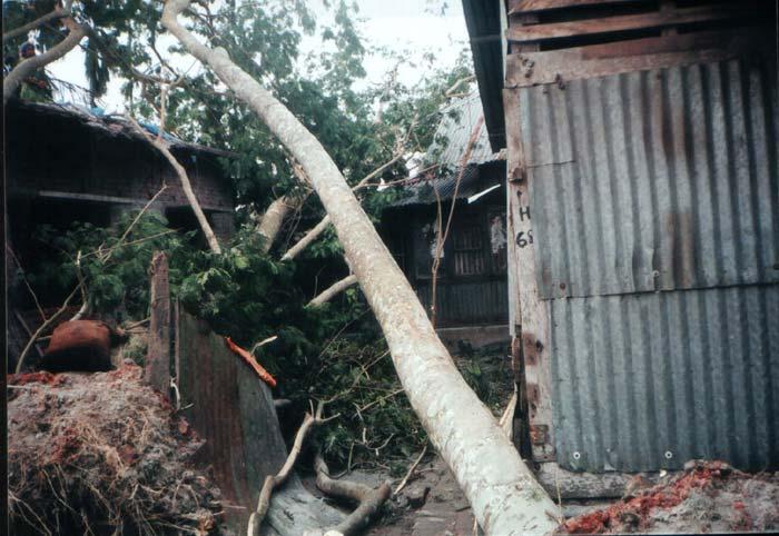
57 Few damage activities by cyclone Aila


58
59


60
61 Conclusion BMD monitored and forecasted the cyclones SIDR and AILA very efficiently which help to reduce causalities and economy. But improvement of forecasting related to cyclones will help further reduction of lives and properties. To reduce the vulnerability and to cope up with the cyclone related disaster, improved signal system and strategy of each organization have been incorporated in the upgraded SOD.

62 Gratitude to AWCI for considering Meghna River Basin of Bangladesh as one of the demonstration Basins THANK YOU
COUNTRY PRESENTATION ON MR JAYNAL ABEDIN JOINT SECRETARY ( WORKS & DEVELOPMENT ) MINISTRY OF DEFENCE
 MINISTRY OF DEFENCE") COUNTRY PRESENTATION ON By MR JAYNAL ABEDIN JOINT SECRETARY ( WORKS & DEVELOPMENT ) MINISTRY OF DEFENCE Bangladesh Geographical Location of Bangladesh Bangladesh Country at a Glance Physical Features 1,230
COUNTRY PRESENTATION ON By MR JAYNAL ABEDIN JOINT SECRETARY ( WORKS & DEVELOPMENT ) MINISTRY OF DEFENCE Bangladesh Geographical Location of Bangladesh Bangladesh Country at a Glance Physical Features 1,230
EFFECTIVE TROPICAL CYCLONE WARNING IN BANGLADESH
 Country Report of Bangladesh On EFFECTIVE TROPICAL CYCLONE WARNING IN BANGLADESH Presented At JMA/WMO WORKSHOP ON EFFECTIVE TROPICAL CYCLONE WARNING IN SOUTHEAST ASIA Tokyo, Japan,11-14 March 2014 By Sayeed
43rd Session of The WMO/ESCAP PANEL on Tropical Cyclones New Delhi, India May, 2016
 43rd Session of The WMO/ESCAP PANEL on Tropical Cyclones New Delhi, India 02-06 May, 2016 Shamsuddin Ahmed Director Bangladesh Meteorological Department METEOROLOGY Cyclonic Disturbances over the Bay of
Country Report of Bangladesh On
 Country Report of Bangladesh On EFFECTIVE TROPICAL CYCLONE WARNING IN BANGLADESH Presented At JMA/WMO WORKSHOP ON EFFECTIVE TROPICAL CYCLONE WARNING IN SOUTHEAST ASIA Tokyo, Japan 11-14 March 2014 By Sayeed
Cyclone forecasting and its constrains for the Bay of Bengal
 Annex IV JMA/WMO WORKSHOP ON EFFECTIVE TROPICAL CYCLONE WARNING IN SOUTHEAST ASIA Tokyo, Japan 11-14 March 2014 Cyclone forecasting and its constrains for the Bay of Bengal Submitted by Kawsar Parvin Meteorologist
WEATHER FORECAST DHAKA
 WEATHER FORECAST DHAKA 06.09.2018 Hourly 2 PM 4 PM 8 PM 11 PM Temp. / Dew Point 32 / 24 30 / 24 28 / 24 28 / 25 Wind 27 km/h SE 27 km/h SE 24 km/h SE 21 km/h SE Humidity 63% 68% 78% 80% Chance of Precip
International Journal of Integrated Sciences & Technology 2 (2016) 55-61
 55-61") International Journal of Integrated Sciences & Technology 2 (2016) 55-61 Changes in Latent Heat Energy and Moist Static Energy Contents of the Atmosphere over Bangladesh and Neighbourhood during the Formation
International Journal of Integrated Sciences & Technology 2 (2016) 55-61 Changes in Latent Heat Energy and Moist Static Energy Contents of the Atmosphere over Bangladesh and Neighbourhood during the Formation
CYCLONE LAILA RED WARNING. May 19, 2010 (23.45 hrs)
") CYCLONE LAILA RED WARNING May 19, 2010 (23.45 hrs) The severe cyclonic storm LAILA over westcentral and adjoining southwest Bay of Bengal remained practically stationary and lay centred at 2030 hrs IST
CYCLONE LAILA RED WARNING May 19, 2010 (23.45 hrs) The severe cyclonic storm LAILA over westcentral and adjoining southwest Bay of Bengal remained practically stationary and lay centred at 2030 hrs IST
WEATHER FORECAST DHAKA
 WEATHER FORECAST DHAKA 21.10.2017 Hourly 1 PM 4 PM 8 PM 11 PM Temp. / Dew Point 26 / 24 26 / 23 26 / 22 26 / 22 Wind 20 km/h S 29 km/h SSW 17 km/h SW 13 km/h WSW Humidity 91% 86% 79% 78% Chance of Precip
JCOMM-CHy Coastal Inundation Forecasting Demonstration Project (CIFDP)
") WMO World Meteorological Organization Working together in weather, climate and water JCOMM-CHy Coastal Inundation Forecasting Demonstration Project (CIFDP) Coastal Flooding & Vulnerable Populations Coastal
WMO World Meteorological Organization Working together in weather, climate and water JCOMM-CHy Coastal Inundation Forecasting Demonstration Project (CIFDP) Coastal Flooding & Vulnerable Populations Coastal
Analysis of Historical Pattern of Rainfall in the Western Region of Bangladesh
 24 25 April 214, Asian University for Women, Bangladesh Analysis of Historical Pattern of Rainfall in the Western Region of Bangladesh Md. Tanvir Alam 1*, Tanni Sarker 2 1,2 Department of Civil Engineering,
Coastal Inundation Forecasting and Community Response in Bangladesh
 WMO Coastal Inundation Forecasting and Community Response in Bangladesh Bapon (SHM) Fakhruddin Nadao Kohno 12 November 2015 System Design for Coastal Inundation Forecasting CIFDP-PSG-5, 14-16 May 2014,
Saiful Islam Anisul Haque
 Workshop on Disaster Prevention/Mitigation Measures against Floods and Storm Surges in Bangladesh on 17-21 November, 2012, in Kyoto University, Japan Component 2: Flood disaster risk assessment and mitigation
ANNOUNCEMENT WMO/ESCAP PANEL ON TROPICAL CYCLONES THIRTY-EIGHTH SESSION NEW DELHI, INDIA
 WMO IMD ESCAP ANNOUNCEMENT THIRTY-EIGHTH SESSION NEW DELHI, INDIA (21-25 February 2011) HISTORICAL BACKGROUND The tropical cyclones are particularly severe in the north Indian Ocean region. The northern
Government of Sultanate of Oman Public Authority of Civil Aviation Directorate General of Meteorology. National Report To
 Government of Sultanate of Oman Public Authority of Civil Aviation Directorate General of Meteorology National Report To Panel on Tropical Cyclones in the Bay of Bengal And Arabian Sea 43rd Session, India
Frank Revitte National Weather Service. Weather Forecast Office New Orleans/Baton Rouge
 Frank Revitte National Weather Service Weather Forecast Office New Orleans/Baton Rouge Above normal activity 17 Total Named Storms 7 Tropical Storms 4 Hurricanes 6 Major Hurricanes Not the most active,
8.1 Attachment 1: Ambient Weather Conditions at Jervoise Bay, Cockburn Sound
 8.1 Attachment 1: Ambient Weather Conditions at Jervoise Bay, Cockburn Sound Cockburn Sound is 20km south of the Perth-Fremantle area and has two features that are unique along Perth s metropolitan coast
A TRANSFORMED COORDINATE MODEL TO PREDICT TIDE AND SURGE ALONG THE HEAD BAY OF BENGAL- APPLICATION TO CYCLONE OF 1991 AND 1970
 GANIT J. Bangladesh Math. Soc. (ISSN 1606-3694) 35 (015) 7-5 A TRANSFORMED COORDINATE MODEL TO PREDICT TIDE AND SURGE ALONG THE HEAD BAY OF BENGAL- APPLICATION TO CYCLONE OF 1991 AND 1970 Farzana Hussain
Management in Surface, Climate and Upper-air Observations in RAII,Tokyo, Assistant Director Bangladesh Meteorological Department
 JMA / WMO Workshop on Quality Management in Surface, Climate and Upper-air Observations in RAII,Tokyo, 27-30 July 2010 Shamsuddin Ahmed Assistant Director Bangladesh Meteorological Department Bangladesh
Tropical Storm Harvey: SE Texas Impacts
 Tropical Storm Harvey: SE Texas Impacts 10 AM CDT UPDATE Thursday, August 24, 2017 Prepared by: Dan Reilly, Brian Kyle PLEASE MUTE YOUR LINES AND DON T PUT ON HOLD! Situation Overview Tropical Storm Harvey
Hurricane Matthew Threats and Impacts Briefing for Eastern NC
 Hurricane Matthew Threats and Impacts Briefing for Eastern NC October 6 th, 2016 Date/Time Created: 10/6/2016, Noon EDT National Weather Service Newport/Morehead City, NC Hurricane Matthew Key Points Changes
GC Briefing. Weather Sentinel Tropical Storm Michael. Status at 8 AM EDT (12 UTC) Today (NHC) Discussion. October 11, 2018
 Today (NHC) Discussion. October 11, 2018") GC Briefing Weather Sentinel Tropical Storm Michael October 11, 2018 After making landfall as a high-end category-4 hurricane on the Florida Panhandle, Michael weakened to tropical storm status early this
GC Briefing Weather Sentinel Tropical Storm Michael October 11, 2018 After making landfall as a high-end category-4 hurricane on the Florida Panhandle, Michael weakened to tropical storm status early this
Major Hurricane Matthew Briefing Situation Overview
 Major Hurricane Matthew Briefing Situation Overview THIS IS NOW A WORST CASE STORM SURGE SCENARIO Catastrophic Damage is Anticipated for Coastal Areas. Major Hurricane Matthew is still expected to move
Bangladesh and India: Cyclone AILA
 Bangladesh and India: Cyclone AILA Information bulletin n 1 GLIDE n TC-2009-000105-BGD TC-2009-000105-IND 26 May 2009 This bulletin is being issued for information only and reflects the current situation
Evacuation Alarm Using the Improved Magnitude Method to Damage Caused by Typhoon 9918
 ICHE 2014, Hamburg - Lehfeldt & Kopmann (eds) - 2014 Bundesanstalt für Wasserbau ISBN 978-3-939230-32-8 Evacuation Alarm Using the Improved Magnitude Method to Damage Caused by Typhoon 9918 R. Hashimura
Tropics: Weather Forecasting And Early Warning System in Bangladesh.
 Regional Workshop on Impact-based Forecast in RA II (Asia) 07-09,November 2017 Seoul, Republic of Korea. Tropics: Weather Forecasting And Early Warning System in Bangladesh. Md. Sanaul Hoque Mondal Assistant
Bistandsprosjekter i Sørøst-Asia
 Bistandsprosjekter i Sørøst-Asia -Sikre liv og verdier Lars R. Hole, Hanneke Luijting, Tor Ivar Mathisen og Kristine Gjesdal September 2017 Norwegian Meteorological Institute Background Ministry of Foreign
Meteorological Hazards and Current Approach to Observing, Modelling and Predicting Severe Events in Sri Lanka
 Regional Workshop on Impact-based Forecasts in RA II (Asia) 7-9, November, 2017, Seoul, Republic of Korea Meteorological Hazards and Current Approach to Observing, Modelling and Predicting Severe Events
Disaster Risk Management in India. Kamal Kishore New Delhi, 27 October 2016
 Disaster Risk Management in India Kamal Kishore New Delhi, 27 October 2016 Hazard, Exposure and Vulnerability Disaster Prevention Mitigation Hurricane Matthew: Cuba & Haiti Emergency Response Coordination
Marshall Alexander Forecaster Commonwealth of Dominica
 Marshall Alexander Forecaster Commonwealth of Dominica Dominica 2015 Impacts Tropical Storm Danny (August 24 th ) Tropical Storm Erika (August 27 th ) Tropical Storm Grace (Remnants) (September 10 th -11
Tropical Cyclone Sandy (AL182012)
") Tropical Cyclone Sandy (AL182012) Event Briefing Caribbean Risk Managers Ltd Facility Supervisor 29 October 2012 Facility Supervisor: Caribbean Risk Managers Ltd Email: ccrif@ccrif.org Tel (Barbados):
Tropical Cyclone Sandy (AL182012) Event Briefing Caribbean Risk Managers Ltd Facility Supervisor 29 October 2012 Facility Supervisor: Caribbean Risk Managers Ltd Email: ccrif@ccrif.org Tel (Barbados):
WEATHER FORECAST DHAKA
 WEATHER FORECAST DHAKA 02.07.2018 Hourly 2 PM 4 PM 8 PM 11 PM Temp. / Dew Point 32 / 26 31 / 26 28 / 25 28 / 25 Wind 13 km/h S 12 km/h S 15 km/h S 12 km/h S Humidity 74% 77% 83% 84% Chance of Precip 73%
photo courtesy of
 BRITISH VIRGIN ISLANDS REPORT TROPICAL STORM JEANNE photo courtesy of www.bviplatinum.com PREPARED BY THE DEPARTMENT OF DISASTER MANAGEMENT 1 EVENT 13 th -16 th September, 2004 TROPICAL STORM JEANNE Sequence
Country Presentation-Nepal
 Country Presentation-Nepal Mt.Everest, Shiva Pd. Nepal, DHM South Asia Drought Monitor Workshop Dhaka Bangladesh 2 th April 215 Overview Brief Climatology Climate activities- DHM PPCR (Pilot Program for
Tropical Cyclone Warning System in the Philippines
 Republic of the Philippines Department of Science and Technology PHILIPPINE ATMOSPHERIC GEOPHYSICAL AND ASTRONOMICAL SERVICES ADMINISTRAION (PAGASA) Science Garden Compound, Agham Road, Diliman, Quezon
Presentation on RSMC Nadi-TCC Activities
 6 th TC RSMC Technical Coordination Meeting, Brisbane, Australia, 2 5 Nov 2009 Presentation on RSMC Nadi-TCC Activities R. Prasad Director RSMC Nadi-TCC NADI TROPICAL CYCLONE CENTRE RSMC NADI - TCC Approved
Tokyo, Japan March Discussed By: May Khin Chaw, Kyaw Lwin Oo. Department of Meteorology and Hydrology
 Tokyo, Japan 11-14 March 2014 Discussed By: May Khin Chaw, Kyaw Lwin Oo Department of Meteorology and Hydrology Manpower: Out of DMH s total (1425), we are Working with (780) Staffs. 55% (37) stations
Hurricane Irma Page 1 HURRTRAK RM/Pro 2017 Summary Report for Tampa, FL 09/10/ EDT, Adv. # 46
 Hurricane Irma Page 1 Description of impact to Tampa, FL, Tampa, FL, is expected to receive a major impact from Hurricane Irma. The forecast maximum wind for this location has increased since the last
Improving global coastal inundation forecasting WMO Panel, UR2014, London, 2 July 2014
 Improving global coastal inundation forecasting WMO Panel, UR2014, London, 2 July 2014 Cyclone Sidr, November 2007 Hurricane Katrina, 2005 Prof. Kevin Horsburgh Head of marine physics, UK National Oceanography
Tropical Storm Colin Briefing Last Briefing on this System
 Tropical Storm Colin Briefing Last Briefing on this System NWS WFO Jacksonville, Florida Tuesday, June 07, 2016 6:00 a.m. EDT Tropical Storm Colin s Impacts SE Georgia & North Florida Local Watches & Warnings:
Impact of Tropical Cyclones - Malaysia's Experience
 Impact of Tropical Cyclones - Malaysia's Experience ALUI BAHARI MALAYSIAN METEOROLOGICAL DEPARTMENT MINISTRY OF SCIENCE, TECHNOLOGY AND INNOVATION SCOPE Introduction Case Studies of Tropical Cyclones Impacting
Coastal Inundation Forecasting Demonstration Project CIFDP. Flood Forecasting Initiative-Advisory Group (FFI-AG 3), Geneva, 5-7 Dec, 2017
, Geneva, 5-7 Dec, 2017") Coastal Inundation Forecasting Demonstration Project CIFDP Flood Forecasting Initiative-Advisory Group (FFI-AG 3), Geneva, 5-7 Dec, 2017 Coastal Flooding & Vulnerable Populations Coastal populations are
Coastal Inundation Forecasting Demonstration Project CIFDP Flood Forecasting Initiative-Advisory Group (FFI-AG 3), Geneva, 5-7 Dec, 2017 Coastal Flooding & Vulnerable Populations Coastal populations are
Land Mass Change along the Bangladesh Coastline
 Land Mass Change along the Bangladesh Coastline Manar Hasan CE 394K.3 Fall 2016 December 2 nd, 2016 Introduction Motivation Bangladesh is a small country in Asia with a massive population. Always somewhere
Vulnerability of Bangladesh to Cyclones in a Changing Climate
 Vulnerability of Bangladesh to Cyclones in a Changing Climate Susmita Dasgupta Kiran Pandey Mainul Huq Zahirul Huq Khan M.M. Zahid Ahmed Nandan Mukherjee Malik Fida Khan 2010 Bangladesh: Tropical Cyclone
Available online Journal of Scientific and Engineering Research, 2018, 5(3): Research Article
: Research Article") Available online www.jsaer.com, 2018, 5(3):166-180 Research Article ISSN: 2394-2630 CODEN(USA): JSERBR Impact of Climate Variability on Human Health- A Case Study at Kanchanpur Union, Basail, Tangail District,
Available online www.jsaer.com, 2018, 5(3):166-180 Research Article ISSN: 2394-2630 CODEN(USA): JSERBR Impact of Climate Variability on Human Health- A Case Study at Kanchanpur Union, Basail, Tangail District,
Enhancing Preparedness and Early Warning in Disaster Risk Reduction
 Enhancing Preparedness and Early Warning in Disaster Risk Reduction Fifth Technical Conference on Management of Meteorological and Hydrological Services in Regional Association V at PETALING JAYA, MALAYSIA
NWS HURRICANES June 3, 2015
 NWS HURRICANES June 3, 2015 Hurricane Season June 1 November 30 2 What s the concern? All tropical systems passing within 125nm of central Maryland since 1950 Mid-Atlantic Hurricanes Greatest Risk: August
Impact of Coastal Flooding on Land use Pattern Considering Climate Change
 Impact of Coastal Flooding on Land use Pattern Considering Climate Change Pronab Kumar Halder Institute of Water and Flood Management (IWFM), Bangladesh University of Engineering and Technology (BUET),pronab.halder@gmail.com
ROLE OF INDIA METEOROLOGICAL DEPARTMENT IN MANAGEMENT OF METEOROLOGICAL HAZARDS IN INDIA M MOHAPATRA
 ROLE OF INDIA METEOROLOGICAL DEPARTMENT IN MANAGEMENT OF METEOROLOGICAL HAZARDS IN INDIA M MOHAPATRA INDIA METEOROLOGICAL DEPARTMENT NEW DELHI-110003 mohapatraimd@gmail.com Introduction Presentation layout
PRE MONSOON TROPICAL CYCLONE ALERT (LAILA)
") PRE MONSOON TROPICAL CYCLONE ALERT (LAILA) (Updated as on 19 th May, 2010, 10.00 AM) A pre-monsoon Tropical Cyclone alert has been issued for all the coastal districts of Orissa by the Special Relief Commissioner
PRE MONSOON TROPICAL CYCLONE ALERT (LAILA) (Updated as on 19 th May, 2010, 10.00 AM) A pre-monsoon Tropical Cyclone alert has been issued for all the coastal districts of Orissa by the Special Relief Commissioner
ARUBA CLIMATOLOGICAL SUMMARY 2017 PRECIPITATION
 ARUBA CLIMATOLOGICAL SUMMARY 2017 PRECIPITATION The total amount of rainfall recorded at Reina Beatrix International Airport for the year 2017 was 391.0 mm. This is 17.1 % below normal ( Figure 1 ). During
Weather and Climate of the Rogue Valley By Gregory V. Jones, Ph.D., Southern Oregon University
 Weather and Climate of the Rogue Valley By Gregory V. Jones, Ph.D., Southern Oregon University The Rogue Valley region is one of many intermountain valley areas along the west coast of the United States.
UPDATE OF REGIONAL WEATHER AND SMOKE HAZE (December 2017)
") UPDATE OF REGIONAL WEATHER AND SMOKE HAZE (December 2017) 1. Review of Regional Weather Conditions for November 2017 1.1 In November 2017, Southeast Asia experienced inter-monsoon conditions in the first
UPDATE OF REGIONAL WEATHER AND SMOKE HAZE (December 2017) 1. Review of Regional Weather Conditions for November 2017 1.1 In November 2017, Southeast Asia experienced inter-monsoon conditions in the first
Recent development of the National Hydro-Meteorological Service (NHMS) of Viet Nam for disaster risk reduction
 of Viet Nam for disaster risk reduction") Ministry of Natural Resources and Environment National Hydro-Meteorological Service Recent development of the National Hydro-Meteorological Service (NHMS) of Viet Nam for disaster risk reduction Tran Van
Ministry of Natural Resources and Environment National Hydro-Meteorological Service Recent development of the National Hydro-Meteorological Service (NHMS) of Viet Nam for disaster risk reduction Tran Van
TROPICAL CYCLONE TC 03A FOR THE PERIOD 3 RD JUNE TO 10 TH JUNE, 1998
 TROPICAL CYCLONE TC 03A FOR THE PERIOD 3 RD JUNE TO 10 TH JUNE, 1998 Hazrat Mir, Abdul Rashid, Waqarul Wheed Khan. Introduction: This report gives the review of cyclonic storm formed over the East Arabian
EARLY WARNING IN SOUTHERN AFRICA:
 EARLY WARNING IN SOUTHERN AFRICA: Enhancing the Meteorological Early Warning System Eugene Poolman South African Weather Service OUTLINE OF PRESENTATION Impact of Climate Change Meteorological Early Warning
WEATHER FORECAST DHAKA
 WEATHER FORECAST DHAKA 05.09.2018 Hourly 2 PM 4 PM 8 PM 11 PM Temp. / Dew Point 33 / 25 32 / 25 29 / 24 28 / 25 Wind 18 km/h ESE 16 km/h SE 15 km/h SE 15 km/h ESE Humidity 64% 67% 78% 81% Chance of Precip
Tornado Hazard Risk Analysis: A Report for Rutherford County Emergency Management Agency
 Tornado Hazard Risk Analysis: A Report for Rutherford County Emergency Management Agency by Middle Tennessee State University Faculty Lisa Bloomer, Curtis Church, James Henry, Ahmad Khansari, Tom Nolan,
PROBABILISTIC EXTREMES OF THE FREQUENCY OF THUNDERSTORM DAYS OVER BANGLADESH DURING THE PRE- MONSOON SEASON
 225 PROBABILISTIC EXTREMES OF THE FREQUENCY OF THUNDERSTORM DAYS OVER BANGLADESH DURING THE PRE- MONSOON SEASON Samarendra Karmakar Bangladesh Meteorological Department, Sher-e-Bangla Nagar, Agargaon Dhaka-1207,
Impact of Cyclone Nargis
 Lessons Learnt from Nargis Recovery for the Next Disaster International Recovery Forum (2011) 12, JAN 2011, Kobe, Japan Home for over 100 national races. Profile of Myanmar The 2 nd largest country in
Coastal Storms of the New Jersey Shore
 Coastal Storms of the New Jersey Shore Dr. Steven G. Decker Dept. of Environmental Sciences School of Environmental and Biological Sciences Rutgers University May 25, 2011 Overview Threats Historical Examples
Life Cycle of Convective Systems over Western Colombia
 Life Cycle of Convective Systems over Western Colombia Meiry Sakamoto Uiversidade de São Paulo, São Paulo, Brazil Colombia Life Cycle of Convective Systems over Western Colombia Convective System (CS)
Storm Surge Modelling based on Analysis of Historical Cyclones for Patuakhali District of Bangladesh
 IOSR Journal of Environmental Science, Toxicology and Food Technology (IOSR-JESTFT) e-issn: 2319-2402,p- ISSN: 2319-2399.Volume 12, Issue 4 Ver. II (April. 2018), PP 35-44 www.iosrjournals.org Storm Surge
ERTH 365 Homework #2: Hurricane Harvey. 100 points
 ERTH 365 Homework #2: Hurricane Harvey 100 points Due by 6pm, Tuesday 30 October 2018, ELECTRONIC SUBMISSON BY EMAIL ONLY BY 6PM (send to klevey@sfsu.edu) (acceptable formats: MS Word, Google Doc, plain
Hurricane Matthew. Life Threatening Flash Flooding Likely. National Weather Service Wilmington NC. Josh Weiss, Meteorologist
 Hurricane Matthew Life Threatening Flash Flooding Likely Threat Assessment for northeast South Carolina & southeast North Carolina National Weather Service Wilmington NC 630 PM EDT Friday October 7, 2016
NOAA s National Weather Service Philadelphia/Mt. Holly NJ
 Next Briefing Package: Friday, October 2, 2015 no later than 300 PM Hazards and Impacts: Overview: A dangerous weather pattern still threatens our region. Threats include very heavy rainfall, inland river
Weather Forecasting in Flood Forecasting Activities
 Weather Forecasting in Flood Forecasting Activities Eugene Poolman South African Weather Service Representing CBS Pretoria South Africa FCAST PRES 20130919 001 Main Activities of CBS Development, implementation
Activities Related to Disaster Management for Earthquake In Bangladesh
 Activities Related to Disaster Management for Earthquake In Bangladesh I. ABSTRACT Ms. Suraiya Begum & Md. Shah Alam, Principal Scientific Officer, Bangladesh Space Research & Remote Sensing Organization
Highlights. Situation Overview
 Situation report issued by NDMO Vanuatu This report covers the period from 10 March 2015 Highlights Tropical Cyclone Pam Cat 3 enters Vanuatu grid at 8:00 on 11 March 2013. The Vanuatu Met Services has
Role of Hydro-Met Services in Disaster Risk Management
 Role of Hydro-Met Services in Disaster Risk Management Tshewang Rigzin (Mr) National Centre for Hydrology and Meteorology, Bhutan 30 th November 2017 Outline Vision and Mission Functions related to Disaster
Response and Lesson Learned from Typhoon YOLANDA (HAIYAN)
") 9 th NARBO IWRM Training Tagaytay City May 12-19, 2014 Response and Lesson Learned from Typhoon YOLANDA (HAIYAN) Rene B. Paciente Weather Division, PAGASA Philippines OUTLINE 1. Meteorological Informations
9 th NARBO IWRM Training Tagaytay City May 12-19, 2014 Response and Lesson Learned from Typhoon YOLANDA (HAIYAN) Rene B. Paciente Weather Division, PAGASA Philippines OUTLINE 1. Meteorological Informations
CORRELATION BETWEEN TEMPERATURE CHANGE AND EARTHQUAKE IN BANGLADESH
 CORRELATION BETWEEN TEMPERATURE CHANGE AND EARTHQUAKE IN BANGLADESH A. Hossain *, F. Kabir & K. Roy Department of Civil Engineering, Rajshahi University of Engineering & Technology, Rajshahi, Bangladesh
Ms. Latoya Regis. Meteorologist Hydrometeorological Service, Guyana
 Ms. Latoya Regis Meteorologist Hydrometeorological Service, Guyana Background Ninety percent (90%) of Guyana s population resides along the (Atlantic) Coast, which is below mean sea level and accounts
SEISMIC RISK ASSESSMENT IN ARMENIA
 SEISMIC RISK ASSESSMENT IN ARMENIA Hovhannes Khangeldyan Head of National Crisis Management Center Rescue Service Ministry of Emergency Situations of the Republic of Armenia Tokyo, 2016 ARMENIA: GEOGRAPHICAL
教育啓蒙への利活用を考慮した防災技術情報アーカイブシステムの開発 (2013)
") Title Program 1 : Preparedness Program fo Impact Author(s) SOE, Aye Aye Citation 教育啓蒙への利活用を考慮した防災技術情報アーカイブシステムの開発 (2013) Issue Date 2013-06 URL http://hdl.handle.net/2433/175523 Right Type Article Textversion
Title Program 1 : Preparedness Program fo Impact Author(s) SOE, Aye Aye Citation 教育啓蒙への利活用を考慮した防災技術情報アーカイブシステムの開発 (2013) Issue Date 2013-06 URL http://hdl.handle.net/2433/175523 Right Type Article Textversion
Chantale Bijoux Meteorological Officer
 Chantale Bijoux Meteorological Officer Introduction The Seychelles s National Meteorological Services plays a vital role in providing weather and climate information including severe weather changes, therefore
Tropical season reports and submitted by New-Caledonia
 Tropical season reports 2014-2015 and 2015-2016 submitted by New-Caledonia RA V Tropical Cyclone Committee 16th session Honiara, Salomon Islands 29 Aug 2 Sept 2016 Tropical cyclone warning system: Warning
Republic of Mozambique
 Republic of Mozambique Second Expert's Symposium on Multi-Hazard Early Warning Systems with focus on the Role of National Meteorological and Hydrological Services 5-7 May 2009, Toulouse France 1. Background
WEDNESDAY 30 TH AUGUST, :57 p.m. Tropical Storm Irma forms in the Atlantic. Don t let your guard down, always #Be Ready.
 Chapter 1 - The Set Up In the days leading up to Irma a series of composed and sobering text messages, presented in truncated form below, from Department of Disaster Management warned us of the pending
Application of Satellite Data for Flood Forecasting and Early Warning in the Mekong River Basin in South-east Asia
 MEKONG RIVER COMMISSION Vientiane, Lao PDR Application of Satellite Data for Flood Forecasting and Early Warning in the Mekong River Basin in South-east Asia 4 th World Water Forum March 2006 Mexico City,
THE UNITED REPUBLIC OF TANZANIA MINISTRY OF WORKS, TRANSPORT AND COMMUNICATION TANZANIA METEOROLOGICAL AGENCY
 THE UNITED REPUBLIC OF TANZANIA MINISTRY OF WORKS, TRANSPORT AND COMMUNICATION TANZANIA METEOROLOGICAL AGENCY CLIMATE OUTLOOK FOR TANZANIA MARCH MAY, 2018 MASIKA RAINFALL SEASON Highlights for March May,
(April 7, 2010, Wednesday) Tropical Storms & Hurricanes Part 2
 Tropical Storms & Hurricanes Part 2") Lecture #17 (April 7, 2010, Wednesday) Tropical Storms & Hurricanes Part 2 Hurricane Katrina August 2005 All tropical cyclone tracks (1945-2006). Hurricane Formation While moving westward, tropical disturbances
Lecture #17 (April 7, 2010, Wednesday) Tropical Storms & Hurricanes Part 2 Hurricane Katrina August 2005 All tropical cyclone tracks (1945-2006). Hurricane Formation While moving westward, tropical disturbances
ovember 2008 Antigua and Barbuda Meteorological Service
 ovember 2008 Antigua and Barbuda Meteorological Service The Atlantic Hurricane Season Summary 2008 Special Focus on Antigua and Barbuda The Season in Brief Sixteen (16) named storms formed in the Atlantic
Table-Top Exercise for Emergency Preparedness Evaluation: Little Anse, Isle Madame
 Table-Top Exercise for Emergency Preparedness Evaluation: Little Anse, Isle Madame Alexander Chung, M.Sc. Candidate C-Change Student Research Associate May 2013 The Community of Little Anse Coastal community
HURRICANES AND TORNADOES
 HURRICANES AND TORNADOES The most severe weather systems are hurricanes and tornadoes. They occur in extremely low pressure systems, or cyclones, when the air spirals rapidly into the center of a low.
Hurricane Matthew Life Threatening Flash Flooding Likely
 Hurricane Matthew Life Threatening Flash Flooding Likely Threat Assessment for northeast South Carolina & southeast North Carolina National Weather Service Wilmington NC 12 AM EDT Saturday October 8, 2016
The Role of PAGASA in Disaster Mitigation
 The Role of PAGASA in Disaster Mitigation Christopher F. Perez 2017 ACTS Workshop on Extreme Weather Forecast and Water Resource Management Hanoi, Vietnam September 26-27, 2017 Tropical Storm AMANG(Mekkhala),
Hurricane Sandy October 28 th 31 st 2012
 Hurricane Sandy October 28 th 31 st 2012 Prepared 530 PM EDT Saturday October 27, 2012 Gary Szatkowski NOAA s NJ Forecast Office Weather.gov/phi Purpose of Briefing Briefing #7 for event Promote situational
Verification of the Seasonal Forecast for the 2005/06 Winter
 Verification of the Seasonal Forecast for the 2005/06 Winter Shingo Yamada Tokyo Climate Center Japan Meteorological Agency 2006/11/02 7 th Joint Meeting on EAWM Contents 1. Verification of the Seasonal
Hurricane Irma Page 1 HURRTRAK RM/Pro 2017 Summary Report for Tampa, FL 09/09/ EDT, Adv. # 43
 Hurricane Irma Page 1 Description of impact to Tampa, FL, Tampa, FL, is expected to receive a major impact from Hurricane Irma. The forecast maximum wind for this location has decreased since the last
SLOSH New Orleans Basin 2012 Update
 SLOSH New Orleans Basin 2012 Update Michael Koziara Science and Operations Officer National Weather Service Slidell, LA The Basics What is storm surge? What is SLOSH? Details Assumptions Inundation = Storm
JMA/WMO WORKSHOP ON EFFECTIVE TROPICAL CYCLONE WARNING IN SOUTHEAST ASIA
 JMA/WMO WORKSHOP ON EFFECTIVE TROPICAL CYCLONE WARNING IN SOUTHEAST ASIA TROPICAL CYCLONE MONITORING IN LAO PDR TOKYO, JAPAN 11 14 March 2014 Ministry of Natural Resource and Environment (MONRE) Department
Overview of existing Weather Forecasting and Warning infrastructures in Myanmar
 Overview of existing Weather Forecasting and Warning infrastructures in Myanmar by Dr. Zin Mie Mie Sein Officer (DMH) 26. February. 2018 Nay Pyi Taw Outline Introduction Myanmar & its disasters Meteorological
ARUBA CLIMATOLOGICAL SUMMARY 2014 PRECIPITATION
 ARUBA CLIMATOLOGICAL SUMMARY 2014 PRECIPITATION The total amount of rainfall recorded at Reina Beatrix International Airport for the year 2014 was 309.2 mm. This is 34.4 % below normal ( Figure 1 ). During
HURRICANE IRENE. CONFERENCE CALL BRIEFING SLIDES Saturday August 27, :30 AM
 HURRICANE IRENE CONFERENCE CALL BRIEFING SLIDES Saturday August 27, 2011 8:30 AM NHC TRACK AND CONE HURRICANE IRENE WATCHES/WARNINGS Hurricane Warning along south coast including all of Cape Cod and Islands
WEATHER SYSTEMS IMPACTING THE CAYMAN ISLANDS Prepared by the staff of the Cayman Islands National Weather Service
 WEATHER SYSTEMS IMPACTING THE CAYMAN ISLANDS 2008 Prepared by the staff of the Cayman Islands National Weather Service TROPICAL STORM DOLLY Formed 194 miles west of Grand Cayman July 19 th. The tropical
Wainui Beach Management Strategy (WBMS) Summary of Existing Documents. GNS Tsunami Reports
 Summary of Existing Documents. GNS Tsunami Reports") Wainui Beach Management Strategy (WBMS) Summary of Existing Documents GNS Tsunami Reports a) Review of Tsunami Hazard and Risk in New Zealand ( National Risk Report ) b) Review of New Zealand s Preparedness
Wainui Beach Management Strategy (WBMS) Summary of Existing Documents GNS Tsunami Reports a) Review of Tsunami Hazard and Risk in New Zealand ( National Risk Report ) b) Review of New Zealand s Preparedness
Decadal Changes of Rainfall and Temperature Extremes over the different Agro Economical Zones (AEZ) of Bangladesh
 of Bangladesh") Decadal Changes of Rainfall and Temperature Extremes over the different Agro Economical Zones (AEZ) of Bangladesh Professor A.K.M. Saiful Islam Md. Alfi Hasan Institute of Water and Flood Management Bangladesh
Decadal Changes of Rainfall and Temperature Extremes over the different Agro Economical Zones (AEZ) of Bangladesh Professor A.K.M. Saiful Islam Md. Alfi Hasan Institute of Water and Flood Management Bangladesh
Tropical Revolving Storms: Cuba 2008 By The British Geographer
 Place Context Tropical Revolving Storms: Cuba 2008 By The British Geographer The Republic of Cuba is located in the northern tropics with in island chain of the Caribbean. It is made up of one large Island,
Overview of Disaster
 Overview of Disaster Management: Bangladesh Perspective By Md Shah Kamal Secretary Ministry of Disaster Management & Relief Country Profile: Bangladesh Total population : 165 million Total Geographic Area