MIDWEST PROBABLE MAXIMUM PRECIPITATION STUDIES
|
|
|
- Godwin York
- 5 years ago
- Views:
Transcription
1 MIDWEST PROBABLE MAXIMUM PRECIPITATION STUDIES Bill Kappel Senior Meteorologist/Vice President Ed Tomlinson, PhD Chief Meteorologist/President Applied Weather Associates NHA Midwest Regional and Midwest Hydro Users Group Meeting May 15-16, 2013 Lake Delton, WI
2 PMP Definition The theoretically greatest depth of precipitation for a given duration that is physically possible over a given storm area at a particular geographic location at a certain time of year (HMR 59, 1999)
3 Types of PMP studies: PMP Background Generalized (Hydrometeorological Reports) Provides PMP values for a region HMR 57 Columbia River, Snake River, and Coastal drainages Regional/Statewide Provide PMP values over regions with varying topography Individual basins are included in the results Site-Specific Provides PMP values for individual drainage basins Considers unique meteorology and topography

4 Coverage of HMRs
5 AWA PMP Studies Site-specific/statewide PMP values used instead of HMR values to compute the PMF PMP studies have produced significant reductions Individual basins Statewide regions Large regions AWA site-specific and statewide PMP studies have been accepted by appropriate regulators State Dam Safety, Federal Energy Regulator Commission (FERC), Natural Resources Conservation Service (NRCS), etc
6 Do PMP Studies Provide Improved PMP Values? More storms considered New technologies used Problems/Unknowns in the HMRs corrected Topographic features addressed Updated climatologies used Conservatisms relaxed where data supports
7 Background-HMR 51 No orographic procedures used stippled regions Maximum dew point climatology not representative of moisture feeding storms Implicit influence of storms throughout large areas of domain no appropriate Smethport, PA Improper storm analyses Smethport (1942), Yankeetown (1950), Alta Pass (1916) Storm database outdated Most recent general storm: Hurricane Agnes 1972 Most recent Midwest storm: Ritter, Iowa 1953
8 How Does AWA Compute PMP? Storm Based Approach Similar to HMR/WMO procedures Deterministic-but there is uncertainty Maintain consistency with AWA PMP studies Improvements in understanding Expanded database Use of computer technologies Use of NEXRAD weather radar Better understanding of meteorology

9 Not Our First PMP Study

10 Method for Computing PMP Values Identify unique topography/climate Review previous PMP studies Review HMR procedures Identify inconsistent assumptions Apply new technologies and data Apply new/updated methods
11 Updating PMP-What Did We Do Storm Search Update the storm database Identify the most extreme rainfall events Throughout the study area Surrounding regions Identify Storm Types Local Convective Remnant Tropical General Frontal

12 AWA Storm Search Domains

13
14
15 Updating PMP-Storm Analysis Storm Precipitation Analysis System (SPAS) Depth-Area-Duration Mass Curves Storm Isohyetal Hourly (5-minute rainfall) at 1/3 rd square mile Dynamically adjusted radar and/or basemap for spatial interpolation


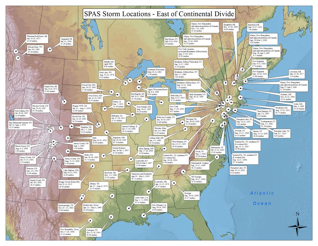
16 SPAS Storm Analysis Results
17 How Does AWA Compute PMP? Each storm maximized Make it as big as physically possible Storm rainfall = dynamics + moisture Can t quantify dynamics, can quantify moisture Assume most efficient storm dynamics Only moisture varies Use surface dew points or SST for maximization Determine moisture which fed the storm = fuel Ratio: climatological maximum moisture to actual storm moisture = in-place maximization factor

18 Maximum Dew Point Map, June 24-hr 100-yr
19 How Does AWA Compute PMP? Move maximized storms to each grid/basin centroid Account for differences in moisture and elevation Storms must be transpositionable Meteorological and topographical similar characteristics Results in total adjustment factor Apply to the DAD values Analyzed Depth-Area and Depth-Duration curves Envelopment for consistency in space and time

20 Dew Point Map, May 24-hr 100-yr

21 Ohio Statewide PMP Reductions from HMR 51

22 Nebraska Statewide PMP Study Results

23 Nebraska Statewide PMP Reductions from HMR 51

24 Dew Point Map, May 24-hr 100-yr
25 What About HUG? Build of PMP work in the region Ohio statewide (2013) Quad Cities (2012) Nebraska statewide (2008) EPRI Michigan/Wisconsin (1993) Leverage off storm lists/analyses Significant cost/time savings Same structure/products Regulator confidence and understanding Involvement of stakeholders from beginning PMP for any point in the region Updateable, flexible, user friendly
26 What About HUG? Return On Investment very high Often pays for itself right away Lower Rehab cost Lower Construction costs Reclaimed Opportunity Costs Flood protection Storage capacities Operational availability
27 Summary Storm based and reproducible Ability to consider site-specific characteristics Higher confidence in results/data Significant cost savings Properly sized spillways Infrastructure not overbuilt PMP study produces updated/reliable values PMP values for any point Developed using the most current methods and data available
28 QUESTIONS Bill Kappel Ed Tomlinson
Updating Probable Maximum Precipitation for the Tennessee Valley Authority
 Updating Probable Maximum Precipitation for the Tennessee Valley Authority Bill Kappel, President/Senior Meteorologist Applied Weather Associates, Monument, CO www.appliedweatherassociates.com Mike Eiffe,
The NEXRAD Revolution: Scientific Basis for Updating the HMR-49 Statistical Storm Intensities and PMPs
 The NEXRAD Revolution: Scientific Basis for Updating the HMR-49 Statistical Storm Intensities and PMPs Bill Kappel, Senior Meteorologist/President Applied Weather Associates, Monument, CO www.appliedweatherassociates.com
Bill Kappel. Doug Hultstrand. Applied Weather Associates
 Cool-Season PMP/PMF Meteorological Time Series for Snow Melt Calculations Bill Kappel Senior Meteorologist/Vice President Doug Hultstrand Hydrometeorologist Applied Weather Associates www.appliedweatherassociates.com
Probable Maximum Precipitation Study
 Probable Maximum Precipitation Study Virginia Floodplain Management Association Workshop Thursday, October 29, 2015 Robert T. Bennett, PE, RA, CFM DCR Dam Safety & Floodplain Management Definition (4VAC50-20-50.H)
TEMPORAL DISTIRUBTION OF PMP RAINFALL AS A FUNCTION OF AREA SIZE. Introduction
 TEMPORAL DISTIRUBTION OF PMP RAINFALL AS A FUNCTION OF AREA SIZE Bill D. Kappel, Applied Weather Associates, LLC Edward M. Tomlinson, Ph.D., Applied Weather Associates, LLC Tye W. Parzybok, Metstat, Inc.
PO Box 680 Monument, Co / appliedweatherassociates.com. Probable Maximum Precipitation (PMP)
") PO Box 680 Monument, Co 80132 719/488-9117 appliedweatherassociates.com Probable Maximum Precipitation (PMP) Probable Maximum Precipitation Introduction Concept of Probable Maximum Precipitation (PMP)
PO Box 680 Monument, Co 80132 719/488-9117 appliedweatherassociates.com Probable Maximum Precipitation (PMP) Probable Maximum Precipitation Introduction Concept of Probable Maximum Precipitation (PMP)
Updating PMP to Provide Better Dam and Spillway Design
 Protections 2016 2 nd International Seminar on Dam Protection Against Overtopping ISBN: 978-1-1889143-27-9 DOI: Ft. Collins, Colorado, USA, 7-9 September 2016 Updating PMP to Provide Better Dam and Spillway
Dam Safety: Revisiting PMPs
 Dam Safety: Revisiting PMPs Many dam safety officials use probable maximum precipitation (PMP) for dam safety evaluations and design requirements. But the series of federal publications that provides PMP
Presented by Jerry A. Gomez, P.E. National Hydropower Association Northeast Regional Meeting - September 17, 2009
 Presented by Jerry A. Gomez, P.E. National Hydropower Association Northeast Regional Meeting - September 17, 2009 Defining Probable Maximum Precipitation (PMP) PMP is the theoretically greatest depth of
Arizona Statewide Probable Maximum Precipitation (PMP), Improving HMR 49
, Improving HMR 49") Arizona Statewide Probable Maximum Precipitation (PMP), Improving HMR 49 Edward M. Tomlinson, Ph.D., Applied Weather Associates, LLC* William D. Kappel, Applied Weather Associates, LLC* Michael Johnson,
Arizona Statewide Probable Maximum Precipitation (PMP), Improving HMR 49 Edward M. Tomlinson, Ph.D., Applied Weather Associates, LLC* William D. Kappel, Applied Weather Associates, LLC* Michael Johnson,
Detailed Storm Rainfall Analysis for Hurricane Ivan Flooding in Georgia Using the Storm Precipitation Analysis System (SPAS) and NEXRAD Weather Radar
 and NEXRAD Weather Radar") Detailed Storm Rainfall Analysis for Hurricane Ivan Flooding in Georgia Using the Storm Precipitation Analysis System (SPAS) and NEXRAD Weather Radar Ed Tomlinson, PhD and Bill Kappel Applied Weather Associates
Detailed Storm Rainfall Analysis for Hurricane Ivan Flooding in Georgia Using the Storm Precipitation Analysis System (SPAS) and NEXRAD Weather Radar Ed Tomlinson, PhD and Bill Kappel Applied Weather Associates
The general procedure for estimating 24-hour PMP includes the following steps:
 14th Conference on Applied Climatology Abstract # 71520 Using PRISM Climate Grids and GIS for Extreme Precipitation Mapping George H. Taylor and Christopher Daly Oregon State University Corvallis Oregon
Site-Specific and Regional PMP Studies
 Site-Specific and Regional Probable Maximum Precipitation (PMP) Studies Ed Tomlinson, PhD 2009 Western Regional Dam Safety Forum San Francisco, California January 15, 2009 PO Box 680 Monument, Co 80132
Using PRISM Climate Grids and GIS for Extreme Precipitation Mapping
 Using PRISM Climate Grids and GIS for Extreme Precipitation Mapping George H. Taylor, State Climatologist Oregon Climate Service 316 Strand Ag Hall Oregon State University Corvallis OR 97331-2209 Tel:
Areal Reduction Factors for the Colorado Front Range and Analysis of the September 2013 Colorado Storm
 Areal Reduction Factors for the Colorado Front Range and Analysis of the September 2013 Colorado Storm Doug Hultstrand, Bill Kappel, Geoff Muhlestein Applied Weather Associates, LLC - Monument, Colorado
Improving Reservoir Management Using the Storm Precipitation Analysis System (SPAS) and NEXRAD Weather Radar
 and NEXRAD Weather Radar") Improving Reservoir Management Using the Storm Precipitation Analysis System (SPAS) and NEXRAD Weather Radar Bill D. Kappel, Applied Weather Associates, LLC, Monument, CO Edward M. Tomlinson, Ph.D., Applied
Improving Reservoir Management Using the Storm Precipitation Analysis System (SPAS) and NEXRAD Weather Radar Bill D. Kappel, Applied Weather Associates, LLC, Monument, CO Edward M. Tomlinson, Ph.D., Applied
ALASKA ENERGY AUTHORITY AEA REP Appendix A. Probable Maximum Precipitation Study REP. Applied Weather Associates
 13-1402-REP-123114 Appendix A Probable Maximum Precipitation Study 14-07-REP by Applied Weather Associates Report 14-07-REP v1.0 Susitna-Watana Hydroelectric Project Probable Maximum Precipitation Study
Areal Reduction Factors for the Colorado Front Range and Analysis of the September 2013 Colorado Storm
 Areal Reduction Factors for the Colorado Front Range and Analysis of the September 2013 Colorado Storm Doug Hultstrand, Bill Kappel, Geoff Muhlestein Applied Weather Associates, LLC - Monument, Colorado
Needs to Update Probable Maximum Precipitation for Determining Hydrologic Loading on Dams
 Needs to Update Probable Maximum Precipitation for Determining Hydrologic Loading on Dams USSD 2017 Annual Conference Anaheim, CA Chandra S. Pathak, PhD, PE, F.ASCE Engineering and Construction Branch
This page left intentionally blank
 This page left intentionally blank Colorado New Mexico Regional Extreme Precipitation Study Summary Report Volume II Deterministic Regional Probable Maximum Precipitation Estimation Prepared by: Applied
Ed Tomlinson, PhD Bill Kappel Applied Weather Associates LLC. Tye Parzybok Metstat Inc. Bryan Rappolt Genesis Weather Solutions LLC
 Use of NEXRAD Weather Radar Data with the Storm Precipitation Analysis System (SPAS) to Provide High Spatial Resolution Hourly Rainfall Analyses for Runoff Model Calibration and Validation Ed Tomlinson,
Colorado September Rainfall Analysis: Comparisons to the Calgary 2013 Rainfall and PMP Along the Rocky Mountain Front Range
 Colorado September Rainfall Analysis: Comparisons to the Calgary 2013 Rainfall and PMP Along the Rocky Mountain Front Range Bill Kappel, President/Senior Meteorologist, Applied Weather Associates, LLC
Comparison of physical and statistical methods for estimating probable maximum precipitation in southwestern basins of Iran
 Fattahi et al. / DESERT 15 (2010) 127-132 DESERT DESERT Online at http://jdesert.ut.ac.ir DESERT 15 (2010) 127-132 Comparison of physical and statistical methods for estimating probable maximum precipitation
Pompton Lakes Dam Downstream Effects of the Floodgate Facility. Joseph Ruggeri Brian Cahill Michael Mak Andy Bonner
 Pompton Lakes Dam Downstream Effects of the Joseph Ruggeri Brian Cahill Michael Mak Andy Bonner ASFPM 2013: Overview Page 2 Overview Page 3 Overview Page 4 Overview Page 5 Overview - Historical Pompton
NRC Workshop Probabilistic Flood Hazard Assessment (PFHA) Jan 29-31, Mel Schaefer Ph.D. P.E. MGS Engineering Consultants, Inc.
 Jan 29-31, Mel Schaefer Ph.D. P.E. MGS Engineering Consultants, Inc.") Stochastic Event Flood Model (SEFM) Stochastic Modeling of Extreme Floods A Hydrological Tool for Analysis of Extreme Floods Mel Schaefer Ph.D. P.E. MGS Engineering Consultants, Inc. Olympia, WA NRC Workshop
Stochastic Event Flood Model (SEFM) Stochastic Modeling of Extreme Floods A Hydrological Tool for Analysis of Extreme Floods Mel Schaefer Ph.D. P.E. MGS Engineering Consultants, Inc. Olympia, WA NRC Workshop
NRC Workshop - Probabilistic Flood Hazard Assessment Jan 2013
 Regional Precipitation-Frequency Analysis And Extreme Storms Including PMP Current State of Understanding/Practice Mel Schaefer Ph.D. P.E. MGS Engineering Consultants, Inc. Olympia, WA NRC Workshop - Probabilistic
9. PROBABLE MAXIMUM PRECIPITATION AND PROBABLE MAXIMUM FLOOD
 9. PROBABLE MAXIMUM PRECIPITATION AND PROBABLE MAXIMUM FLOOD 9.1. Introduction Due to the size of Watana Dam and the economic importance of the Project to the Railbelt, the Probable Maximum Flood (PMF)
Solution: The ratio of normal rainfall at station A to normal rainfall at station i or NR A /NR i has been calculated and is given in table below.
 3.6 ESTIMATION OF MISSING DATA Data for the period of missing rainfall data could be filled using estimation technique. The length of period up to which the data could be filled is dependent on individual
Bill Kappel
 Bill Kappel 719-488-4311 billkappel@appliedweatherassociates.com Education and Training Broadcast Meteorology Degree, Mississippi State University, August 2001 B.S., Physical Science-Geology, Mesa State
New NOAA Precipitation-Frequency Atlas for Wisconsin
 New NOAA Precipitation-Frequency Atlas for Wisconsin #215966 Presentation to the Milwaukee Metropolitan Sewerage District Technical Advisory Team January 16, 2014 Michael G. Hahn, P.E., P.H. SEWRPC Chief
Changes to Extreme Precipitation Events: What the Historical Record Shows and What It Means for Engineers
 Changes to Extreme Precipitation Events: What the Historical Record Shows and What It Means for Engineers Geoffrey M Bonnin National Oceanic and Atmospheric Administration National Weather Service Office
Study 16.5 Probable Maximum Flood (PMF)
") Initial Study Report Meeting Study 16.5 Probable Maximum Flood (PMF) October 22, 2014 Prepared by 10/22/2014 1 Study 16.5 Objectives Develop a site-specific PMP to be used for the derivation of the PMF
Initial Study Report Meeting Study 16.5 Probable Maximum Flood (PMF) October 22, 2014 Prepared by 10/22/2014 1 Study 16.5 Objectives Develop a site-specific PMP to be used for the derivation of the PMF
Folsom Dam Water Control Manual Update
 Folsom Dam Water Control Manual Update Public Workshop April 3, 2014 Location: Sterling Hotel Ballroom 1300 H Street, Sacramento US Army Corps of Engineers BUILDING STRONG WELCOME & INTRODUCTIONS 2 BUILDING
Recent Updates to NOAA/NWS Precipitation Frequency Estimates
 Recent Updates to NOAA/NWS Precipitation Frequency Estimates Geoffrey M. Bonnin Director, Hydrometeorological Design Studies Center Chief, Hydrologic Data Systems Branch Office of Hydrologic Development
Storm Precipitation Analysis System (SPAS) Description. Introduction
 Description. Introduction") Storm Precipitation Analysis System (SPAS) Description Introduction The Weather Bureau (currently the National Weather Service, or NWS) and the Corps of Engineers routinely performed detailed storm precipitation
Storm Precipitation Analysis System (SPAS) Description Introduction The Weather Bureau (currently the National Weather Service, or NWS) and the Corps of Engineers routinely performed detailed storm precipitation
A 21st century HRRR-based approach to estimating probable maximum precipitation to enhance dam safety and community resilience
 30 May 2017 FIRO Science Task Group Workshop A 21st century HRRR-based approach to estimating probable maximum precipitation to enhance dam safety and community resilience Courtesy Bill McCormick, Chief,
IMPROVING HYDROLOGIC ANALYSIS AND APPLICATIONS USING QUALITY WEATHER RADAR DATA AND THE STORM PRECIPITATION ANALYSIS SYSTEM
 IMPROVING HYDROLOGIC ANALYSIS AND APPLICATIONS USING QUALITY WEATHER RADAR DATA AND THE STORM PRECIPITATION ANALYSIS SYSTEM Ed M. Tomlinson, PhD 1 Tye W. Parzybok 2 Bill D. Kappel 3 Doug M. Hultstrand
Estimating Probable Maximum Precipitation for Linau River Basin in Sarawak
 Estimating Probable Maximum Precipitation for Linau River Basin in Sarawak M. Hussain, S. Nadya and F.J. Chia Hydropower Development Division, Sarawak Energy Berhad, 93050, Kuching, Sarawak, Malaysia Date
The Stochastic Event Flood Model Applied to Minidoka Dam on the Snake River, Idaho
 The Stochastic Event Flood Model Applied to Minidoka Dam on the Snake River, Idaho K. L. Bullard 1, M. G. Schaeffer 2, B. A. Barker 3, D. Sutley 4, and V. Leverson 5 1 Bureau of Reclamation, Flood Hydrology
THE NEED FOR AN ADDITIONAL SPILLWAY AT THE SANFORD DAM BOILING SPRING LAKES, NC. Presentation for The Brunswick County Commissioners April 20, 2015
 THE NEED FOR AN ADDITIONAL SPILLWAY AT THE SANFORD DAM BOILING SPRING LAKES, NC Presentation for The Brunswick County Commissioners April 20, 2015 The Sanford Dam Earth Dam constructed in 1961 Drainage
Ground Water Protection Council 2017 Annual Forum Boston, Massachusetts. Ben Binder (303)
") Ground Water Protection Council 2017 Annual Forum Boston, Massachusetts Protecting Groundwater Sources from Flood Borne Contamination Ben Binder (303) 860-0600 Digital Design Group, Inc. The Problem Houston
Ground Water Protection Council 2017 Annual Forum Boston, Massachusetts Protecting Groundwater Sources from Flood Borne Contamination Ben Binder (303) 860-0600 Digital Design Group, Inc. The Problem Houston
On the use of radar rainfall estimates and nowcasts in an operational heavy rainfall warning service
 On the use of radar rainfall estimates and nowcasts in an operational heavy rainfall warning service Alan Seed, Ross Bunn, Aurora Bell Bureau of Meteorology Australia The Centre for Australian Weather
APPENDIX B HYDROLOGY
 APPENDIX B HYDROLOGY TABLE OF CONTENTS 1.0 INTRODUCTION... 1 2.0 PROBABLE MAXIMUM PRECIPITATION (PMP)... 1 3.0 DESIGN FLOW CALCULATION... 1 4.0 DIVERSION CHANNEL SIZING... 2 5.0 REFERENCES... 4 LIST OF
REQUIREMENTS FOR WEATHER RADAR DATA. Review of the current and likely future hydrological requirements for Weather Radar data
 WORLD METEOROLOGICAL ORGANIZATION COMMISSION FOR BASIC SYSTEMS OPEN PROGRAMME AREA GROUP ON INTEGRATED OBSERVING SYSTEMS WORKSHOP ON RADAR DATA EXCHANGE EXETER, UK, 24-26 APRIL 2013 CBS/OPAG-IOS/WxR_EXCHANGE/2.3
Another 100-Year Storm. October 26, 2016 Mark Dennis, PE, CFM
 Another 100-Year Storm October 26, 2016 Mark Dennis, PE, CFM Agenda Are severe rainfall events becoming more frequent? Is there confusion about the 100-year storm that makes it seem like they happen all
Aurora Bell*, Alan Seed, Ross Bunn, Bureau of Meteorology, Melbourne, Australia
 15B.1 RADAR RAINFALL ESTIMATES AND NOWCASTS: THE CHALLENGING ROAD FROM RESEARCH TO WARNINGS Aurora Bell*, Alan Seed, Ross Bunn, Bureau of Meteorology, Melbourne, Australia 1. Introduction Warnings are
Radar Analysis for Design Storm Application
 37th Conference on Radar Meteorology Norman Oklahoma 14 18 September 2015 Norman, OK Radar Analysis for Design Storm Application Baxter E. Vieux, Vieux & Associates, Inc. Annjanette Dodd, Kimley-Horn,
EFFICIENCY OF THE INTEGRATED RESERVOIR OPERATION FOR FLOOD CONTROL IN THE UPPER TONE RIVER OF JAPAN CONSIDERING SPATIAL DISTRIBUTION OF RAINFALL
 EFFICIENCY OF THE INTEGRATED RESERVOIR OPERATION FOR FLOOD CONTROL IN THE UPPER TONE RIVER OF JAPAN CONSIDERING SPATIAL DISTRIBUTION OF RAINFALL Dawen YANG, Eik Chay LOW and Toshio KOIKE Department of
Tutorial 10 - PMP Estimation
 Tutorial 10 - PMP Estimation In Australia, the Probable Maximum Precipitation (PMP) storms are estimated using three generalised methods: Generalised Short Duration Method (GSDM) for short durations. Generalised
Emerging Aviation Weather Research at MIT Lincoln Laboratory*
 Emerging Aviation Weather Research at MIT Lincoln Laboratory* Haig 19 November 2015 *This work was sponsored by the Federal Aviation Administration under Air Force Contract No. FA8721-05-C-0002. Opinions,
Hydrologic Overview & Quantities
 Hydrologic Overview & Quantities It is important to understand the big picture when attempting to forecast. This includes the interactive components and hydrologic quantities. Hydrologic Cycle The complexity
USING GIS TO MODEL AND ANALYZE HISTORICAL FLOODING OF THE GUADALUPE RIVER NEAR NEW BRAUNFELS, TEXAS
 USING GIS TO MODEL AND ANALYZE HISTORICAL FLOODING OF THE GUADALUPE RIVER NEAR NEW BRAUNFELS, TEXAS ASHLEY EVANS While the state of Texas is well-known for flooding, the Guadalupe River Basin is one of
Christopher ISU
 Christopher Anderson @ ISU Excessive spring rain will be more frequent (except this year). Will it be more manageable? Christopher J. Anderson, PhD 89th Annual Soil Management and Land Valuation Conference
Estimation of the probable maximum precipitation in Barcelona (Spain)
") INTERNATIONAL JOURNAL OF CLIMATOLOGY Int. J. Climatol. 31: 1322 1327 (2011) Published online 14 April 2010 in Wiley Online Library (wileyonlinelibrary.com) DOI: 10.1002/joc.2149 Estimation of the probable
INTERNATIONAL JOURNAL OF CLIMATOLOGY Int. J. Climatol. 31: 1322 1327 (2011) Published online 14 April 2010 in Wiley Online Library (wileyonlinelibrary.com) DOI: 10.1002/joc.2149 Estimation of the probable
Tropical Update. 11 AM EDT Wednesday, October 10, 2018 Hurricane Michael, Hurricane Leslie & Tropical Storm Nadine, Caribbean Low (40%)
") Tropical Update 11 AM EDT Wednesday, October 10, 2018 Hurricane Michael, Hurricane Leslie & Tropical Storm Nadine, Caribbean Low (40%) This update is intended for government and emergency response officials,
Tropical Update 11 AM EDT Wednesday, October 10, 2018 Hurricane Michael, Hurricane Leslie & Tropical Storm Nadine, Caribbean Low (40%) This update is intended for government and emergency response officials,
6/9/2014. Software Overview. System Overview
 Future Rainfall 6/9/2014 Curtis Beitel, PE, CFM, Anthony Henry and Wayne Tschirhart, PE, CFM, PMP TFMA Spring 2014 Conference Software Overview 2 Processes Hydrometric DB Event Manager Automatic Low =
Regional Flash Flood Guidance and Early Warning System
 WMO Training for Trainers Workshop on Integrated approach to flash flood and flood risk management 24-28 October 2010 Kathmandu, Nepal Regional Flash Flood Guidance and Early Warning System Dr. W. E. Grabs
An Overview of Operations at the West Gulf River Forecast Center Gregory Waller Service Coordination Hydrologist NWS - West Gulf River Forecast Center
 National Weather Service West Gulf River Forecast Center An Overview of Operations at the West Gulf River Forecast Center Gregory Waller Service Coordination Hydrologist NWS - West Gulf River Forecast
PLANNED UPGRADE OF NIWA S HIGH INTENSITY RAINFALL DESIGN SYSTEM (HIRDS)
") PLANNED UPGRADE OF NIWA S HIGH INTENSITY RAINFALL DESIGN SYSTEM (HIRDS) G.A. Horrell, C.P. Pearson National Institute of Water and Atmospheric Research (NIWA), Christchurch, New Zealand ABSTRACT Statistics
PLANNED UPGRADE OF NIWA S HIGH INTENSITY RAINFALL DESIGN SYSTEM (HIRDS) G.A. Horrell, C.P. Pearson National Institute of Water and Atmospheric Research (NIWA), Christchurch, New Zealand ABSTRACT Statistics
INFLOW DESIGN FLOOD CONTROL SYSTEM PLAN 40 C.F.R. PART PLANT YATES ASH POND 2 (AP-2) GEORGIA POWER COMPANY
 GEORGIA POWER COMPANY") INFLOW DESIGN FLOOD CONTROL SYSTEM PLAN 40 C.F.R. PART 257.82 PLANT YATES ASH POND 2 (AP-2) GEORGIA POWER COMPANY EPA s Disposal of Coal Combustion Residuals from Electric Utilities Final Rule (40 C.F.R.
INFLOW DESIGN FLOOD CONTROL SYSTEM PLAN 40 C.F.R. PART 257.82 PLANT YATES ASH POND 2 (AP-2) GEORGIA POWER COMPANY EPA s Disposal of Coal Combustion Residuals from Electric Utilities Final Rule (40 C.F.R.
Add NOAA nowcoast Layers to Maps
 WebEOC Maps Add-on Quick Reference Guide Add NOAA nowcoast Layers to Maps Overview With Maps Add-on, you can configure an unlimited number of map layers. These layers allow you to control the data you
NOAA Surface Weather Program
 NOAA Surface Weather Program Maintenance Decision Support System Stakeholder Meeting #9 Jim O Sullivan NOAA Surface Weather Program Manager NWS Office of Climate, Water, and Weather Services September
Monte Carlo Simulations for Probabilistic Flood Hazard Assessment
 Monte Carlo Simulations for Probabilistic Flood Hazard Assessment Jemie Dababneh, Ph.D., P.E., 1 and Mark Schwartz, P.E. 1 1 RIZZO Associates, Monroeville, Pennsylvania Presentation to PSA 2017 International
Robert Shedd Northeast River Forecast Center National Weather Service Taunton, Massachusetts, USA
 Robert Shedd Northeast River Forecast Center National Weather Service Taunton, Massachusetts, USA Outline River Forecast Centers FEWS Implementation Status Forcing Data Ensemble Forecasting The Northeast
COMPUTATION OF PROBABLE MAXIMUM PRECIPITATION (PMP) AND ITS UNCERTAINTY
 AND ITS UNCERTAINTY") COMPUTATION OF PROBABLE MAXIMUM PRECIPITATION (PMP) AND ITS UNCERTAINTY A Thesis by ABHISHEK SINGH Submitted to the Office of Graduate and Professional Studies of Texas A&M University in partial fulfillment
COMPUTATION OF PROBABLE MAXIMUM PRECIPITATION (PMP) AND ITS UNCERTAINTY A Thesis by ABHISHEK SINGH Submitted to the Office of Graduate and Professional Studies of Texas A&M University in partial fulfillment
Graduate Courses Meteorology / Atmospheric Science UNC Charlotte
 Graduate Courses Meteorology / Atmospheric Science UNC Charlotte In order to inform prospective M.S. Earth Science students as to what graduate-level courses are offered across the broad disciplines of
USGS ATLAS. BACKGROUND
 USGS ATLAS. BACKGROUND 1998. Asquith. DEPTH-DURATION FREQUENCY OF PRECIPITATION FOR TEXAS. USGS Water-Resources Investigations Report 98 4044. Defines the depth-duration frequency (DDF) of rainfall annual
Comparative Analysis of Hurricane Vulnerability in New Orleans and Baton Rouge. Dr. Marc Levitan LSU Hurricane Center. April 2003
 Comparative Analysis of Hurricane Vulnerability in New Orleans and Baton Rouge Dr. Marc Levitan LSU Hurricane Center April 2003 In order to compare hurricane vulnerability of facilities located in different
Study 16.5 Probable Maximum Flood (PMF)
") Initial Study Report Meeting Study 16.5 Probable Maximum Flood (PMF) March 30, 2016 Prepared by 3/30/2016 1 Study 16.5 Status ISR documents (ISR Part D Overview): Status: Initial Study Report: Parts A,
Initial Study Report Meeting Study 16.5 Probable Maximum Flood (PMF) March 30, 2016 Prepared by 3/30/2016 1 Study 16.5 Status ISR documents (ISR Part D Overview): Status: Initial Study Report: Parts A,
The National Operational Hydrologic Remote Sensing Center Operational Snow Analysis
 The National Operational Hydrologic Remote Sensing Center Operational Snow Analysis World Meteorological Organization Global Cryosphere Watch Snow-Watch Workshop Session 3: Snow Analysis Products Andrew
National Weather Service. Harold H. Opitz Hydrologist in Charge
 National Weather Service Harold H. Opitz Hydrologist in Charge Goals Organization Role of the River Forecast Center Describe Forecast System & Tools Other Details NWS River Forecast Centers Northwest River
Operational Perspectives on Hydrologic Model Data Assimilation
 Operational Perspectives on Hydrologic Model Data Assimilation Rob Hartman Hydrologist in Charge NOAA / National Weather Service California-Nevada River Forecast Center Sacramento, CA USA Outline Operational
Improving Sub-Seasonal to Seasonal Prediction at NOAA
 Improving Sub-Seasonal to Seasonal Prediction at NOAA Dr. Louis W. Uccellini Director, National Weather Service NOAA Assistant Administrator for Weather Services July 13, 2016 Congressional Briefing Value
Assessment of rainfall observed by weather radar and its effect on hydrological simulation performance
 386 Hydrology in a Changing World: Environmental and Human Dimensions Proceedings of FRIED-Water 2014, Montpellier, France, October 2014 (IAHS Publ. 363, 2014). Assessment of rainfall observed by weather
Results of Intensity-Duration- Frequency Analysis for Precipitation and Runoff under Changing Climate
 Results of Intensity-Duration- Frequency Analysis for Precipitation and Runoff under Changing Climate Supporting Casco Bay Region Climate Change Adaptation RRAP Eugene Yan, Alissa Jared, Julia Pierce,
Lecture 2: Precipitation
 2-1 GEOG415 Lecture 2: Precipitation Why do we study precipitation? Precipitation measurement -- depends on the study purpose. Non-recording (cumulative) Recording (tipping bucket) Important parameters
Statewide Topographic Mapping Program
 Statewide Topographic Mapping Program February 28, 2018 www.dotd.la.gov Outline Purpose of the Statewide Topographic Mapping Program History Breakdown of R.S. 48:36 - Topographic Mapping Statewide Topographic
Design Storms for Hydrologic Analysis
 Design Storms for Hydrologic Analysis Course Description This course is designed to fulfill two hours of continuing education credit for Professional Engineers. Its objective is to provide students with
DEPTH-AREA-DURATION ANALYSIS IN A KOREAN RIVER BASIN
 Annual Journal of Hydraulic Engineering, JSCE, Vol.57, 213, February DEPTH-AREA-DURATION ANALYSIS IN A KOREAN RIVER BASIN Young-a SHIN 1, Kaoru TAKARA 2 and Maja OSTRIC 1 1 Student Member of JSCE, Dept.
A Comparative Study of the National Water Model Forecast to Observed Streamflow Data
 A Comparative Study of the National Water Model Forecast to Observed Streamflow Data CE394K GIS in Water Resources Term Project Report Fall 2018 Leah Huling Introduction As global temperatures increase,
Tropical Update. 5 AM EDT Tuesday, September 12, 2017 Post-Tropical Cyclone Irma, Hurricane Jose, & Tropical Wave (10%)
") Tropical Update 5 AM EDT Tuesday, September 12, 2017 Post-Tropical Cyclone Irma, Hurricane Jose, & Tropical Wave (10%) This update is intended for government and emergency response officials, and is provided
Tropical Update 5 AM EDT Tuesday, September 12, 2017 Post-Tropical Cyclone Irma, Hurricane Jose, & Tropical Wave (10%) This update is intended for government and emergency response officials, and is provided
The Kentucky Mesonet: Entering a New Phase
 The Kentucky Mesonet: Entering a New Phase Stuart A. Foster State Climatologist Kentucky Climate Center Western Kentucky University KCJEA Winter Conference Lexington, Kentucky February 9, 2017 Kentucky
LWMMI. Protecting The Communities We Live In. DIRECTORS. David Benforado Village Trustee Village of Shorewood Hills
 Protecting The Communities We Live In. DIRECTORS David Benforado Village Trustee Village of Shorewood Hills David De Angelis Village Manager Village of Elm Grove Joseph Laux Administrator City of Eagle
Talk Overview. Concepts. Climatology. Monitoring. Applications
 Atmospheric Rivers Talk Overview Concepts Climatology Monitoring Applications Satellite View Where is the storm? Where is the impact? Atmospheric Rivers Plume or fire hose of tropical moisture Heavy precipitation
Haiti and Dominican Republic Flash Flood Initial Planning Meeting
 Dr Rochelle Graham Climate Scientist Haiti and Dominican Republic Flash Flood Initial Planning Meeting September 7 th to 9 th, 2016 Hydrologic Research Center http://www.hrcwater.org Haiti and Dominican
Probable Maximum Precipitation Estimates, United States East of the 105th Meridian
 YDROMETEOROLOGICAL REPORT O. 51 Probable Maximum Precipitation Estimates, United States East of the 15th Meridian U.S. DEPARTMET OF COMMERCE ATIOAL OCEAIC AD ATMOSPERIC ADMIISTRATIO U.S. DEPARTMET OF TE
Lessons Learned and Shared
 Lessons Learned and Shared Plan for the worst. Hope for the best. Remember that hope is not a strategy. Agnes 8 Lessons 1. Identify Susceptible Communities 2. Develop a Plan 3. Threat Recognition 4. Review
Climate Adaptation Challenges for Boston s Water and Sewer Systems
 National Association of Flood & Stormwater Management Agencies Climate Adaptation Challenges for Boston s Water and Sewer Systems John P Sullivan P.E. October 15,2014 Boston 1630 Boston 1630-2012 Boston
Hydrologic Research Laboratory Department of Civil and Environmental Engineering University of California, Davis
 Physically-Based Estimation of Maximum Precipitation: Preliminary Results on Application to American River Basin for the December,1996-January,1997 Flood Event Hydrologic Research Laboratory Department
TABLE OF CONTENTS. 3.1 Synoptic Patterns Precipitation and Topography Precipitation Regionalization... 11
 TABLE OF CONTENTS ABSTRACT... iii 1 INTRODUCTION... 1 2 DATA SOURCES AND METHODS... 2 2.1 Data Sources... 2 2.2 Frequency Analysis... 2 2.2.1 Precipitation... 2 2.2.2 Streamflow... 2 2.3 Calculation of
RAINFALL FREQUENCY ANALYSIS FOR NEW BRAUNFELS, TX (or Seems like we ve been having lots of 100-yr storms)
") RAINFALL FREQUENCY ANALYSIS FOR NEW BRAUNFELS, TX (or Seems like we ve been having lots of 100-yr storms) Presented By: SAUL NUCCITELLI, PE, CFM (LAN) BLAKE KRONKOSKY, EIT (LAN) JIM KLEIN, PE (CITY OF
RAINFALL FREQUENCY ANALYSIS FOR NEW BRAUNFELS, TX (or Seems like we ve been having lots of 100-yr storms) Presented By: SAUL NUCCITELLI, PE, CFM (LAN) BLAKE KRONKOSKY, EIT (LAN) JIM KLEIN, PE (CITY OF
LIDAR: Statutory Compliance Benefits for Nebraska Natural Resources
 LIDAR: Statutory Compliance Benefits for Nebraska Natural Resources 2011 Nebraska GIS Symposium La Vista, NE April 21, 2011 Doug Hallum, P.G. Integrated Water Management Coordinator Nebraska Department
LMRFC is one of 13 NWS RFCs. There are 4 RFCs within the Southern Region of the NWS. Southern Region HQ is located in Fort Worth, TX
 LMRFC is one of 13 NWS RFCs There are 4 RFCs within the Southern Region of the NWS. Southern Region HQ is located in Fort Worth, TX The LMRFC hydrologic forecasting program provides hydrologic guidance
Hydrological extremes. Hydrology Flood Estimation Methods Autumn Semester
 Hydrological extremes droughts floods 1 Impacts of floods Affected people Deaths Events [Doocy et al., PLoS, 2013] Recent events in CH and Europe Sardinia, Italy, Nov. 2013 Central Europe, 2013 Genoa and
Rainfall-River Forecasting: Overview of NOAA s Role, Responsibilities, and Services
 Dr. Thomas Graziano Chief Hydrologic Services Division NWS Headquarters Steve Buan Service Coordination Hydrologist NWS North Central River Forecast Center Rainfall-River Forecasting: Overview of NOAA
What the Science Tells Us & How Practitioners Can Use the Science
 What the Science Tells Us & How Practitioners Can Use the Science Presented at APTA Los Angeles, CA Presented by Dr. B. Tod Delaney President, First Environment, Inc. Wed. August 3, 2011 1 Agenda 1. What
ENGINEERING HYDROLOGY
 ENGINEERING HYDROLOGY Prof. Rajesh Bhagat Asst. Professor Civil Engineering Department Yeshwantrao Chavan College Of Engineering Nagpur B. E. (Civil Engg.) M. Tech. (Enviro. Engg.) GCOE, Amravati VNIT,
Mid-West Heavy rains 18 April 2013
 Abstract: Mid-West Heavy rains 18 April 2013 By Richard H. Grumm and Charles Ross National Weather Service State College, PA The relatively wet conditions during the first 16 days of April 2013 set the
Overview and purposes of the meeting
 Overview and purposes of the meeting 1 Flash Floods vs. River Floods Riverine Flooding: is caused by heavy rainfall (and/or snow melt) over long periods e.g., days, leading to rising water levels and flooding
NWS Flood Warning Products plus a Look Ahead
 NWS Flood Warning Products plus a Look Ahead September 21 & 22, 2010 DRBC Flood Warning Users Forum Presented by Gary Szatkowski Meteorologist-in-Charge NOAA s National Weather Service Philadelphia/Mt.