RAINFALL FREQUENCY ANALYSIS FOR NEW BRAUNFELS, TX (or Seems like we ve been having lots of 100-yr storms)
|
|
|
- Duane Ball
- 6 years ago
- Views:
Transcription
")
 JIM KLEIN, PE (CITY OF NEW")
1 RAINFALL FREQUENCY ANALYSIS FOR NEW BRAUNFELS, TX (or Seems like we ve been having lots of 100-yr storms) Presented By: SAUL NUCCITELLI, PE, CFM (LAN) BLAKE KRONKOSKY, EIT (LAN) JIM KLEIN, PE (CITY OF NEW BRAUNFELS)

2 AGENDA 1. RECENT STORM REVIEW 2. HISTORY OF RAINFALL ANALYSIS 3. UPDATED ANALYSIS 4. CONCLUSIONS 5. Q & A 1950 FLOOD IN NEW BRAUNFELS


3 PRODUCED >20 RAINFALL IN 24-HRS APPROACHING 500-YR FREQUENCY ~$750M DAMAGES, 31 DEATHS ACROSS TEXAS 1998 FLOOD NWS APPROXIMATED RAINFALL DEPTHS DECEMBER 1998 NRCS STUDY


4 1998 FLOOD GUADALUPE RIVER AT IH-35


5 2002 FLOOD NWS APPROXIMATED RAINFALL DEPTHS PRODUCED EXCESS OF 30 RAINFALL IN 5 DAYS 30 IS SIMILAR TO YEARLY AVERAGE RAINFALL DEPTH FOR COMAL COUNTY


6 2002 FLOOD VOLUME 3 TIMES CANYON DAM S CAPACITY OVERTOPPING THE EMERGENCY SPILLWAY CANYON DAM EMERGENCY SPILLWAY CANYON DAM SPILLWAY FLOWS > 70,000 CFS CANYON DAM GORGE FROM SPILLWAY EROSION CANYON DAM GORGE CREATED EXPOSED MILLIONS OF YEARS OF GEOLOGIC TIME


7 2002 FLOOD SOUTH ACCESS ROAD AFTER FLOOD WATERS RECEEDED


8 2004 FLOOD AROUND6 RAIN IN 6 HOURS NRCS DAM #3 AT BLIEDER S CREEK AT FULL CAPACITY HEAVY RAINFALL DOWNSTREAM OFCANYON DAM, BLIEDER S CREEK, AND DRY COMAL WATERSHEDS NRCS DAM #3 AT BLIEDER S CREEK AT FULL CAPACITY


9 2004 FLOOD DRY COMAL AT LOOP 337


10 2010 FLOOD EXCESS OF 8 RAIN IN 3 HRS GUADALUPE RIVER AT COMMON ST. FLOODING ALONG GUADALUPE AND COMAL RIVERS NWS NEXRAD IMAGERY


11 2010 FLOOD GUADALUPE RIVER AT IH-35


12 2010 FLOOD COMAL RIVER AT SCHLITTERBAHN
13 QUESTIONS AND APPROACH WHY SO MANY BIG RAINS/FLOODS? ARE ALL THESE BIG STORMS ENOUGH TO CHANGE DEFINITION OF A 100-YR RAIN? 1998 TO 2010 HAD AT LEAST 4 LARGE EVENTS LAN S ANALYSIS APPROACH REVIEW RAINFALL DATA FILTER DATA PERFORM STATISTICAL ANALYSIS COMPARE TO PREVIOUS VALUES RECOMMEND CHANGES, IF APPROPRIATE
14 RAINFALL FREQUENCY TERMINOLOGY P = 1/T P= % ANNUAL CHANCE F= FREQUENCY (YEARS) P = 1-(1-F) N P = % PROBABILITY OF AT LEAST ONE EVENT IN N # YEARS COMMON MISCONCEPTIONS 100-YR EVENT ONLY HAPPENS EVERY 100 YEARS 100-YR RAINFALL IS SAME AS 100-YR FLOOD


15 TP-40 NATIONAL RAINFALL ATLAS TP YR 24-HR RAINFALL FIRST NATIONAL STUDY (1962) BY NOAA FAIRLY SHORT RECORD OF GAGE DATA GUMBEL DISTRIBUTION

 REVIEWED NWS")

16 1998 USGS TEXAS RAINFALL STUDY NWS RAINFALL STATIONS USGS WRIR (STUDY) USGS SIR (ATLAS) REVIEWED NWS STATIONS MIN 274 HOURLY 865 DAILY DATA THROUGH 1994 UPDATED STATISTICAL METHODS
17 1998 USGS VS TP-40 RAINFALL CONTOURS
18 USGS 100-YR, 24HR DEPTH COMAL COUNTY 24-HR 100-YR DEPTH
19 NEW BRAUNFELS DEPTH-DURATION-FREQUENCY TABLE

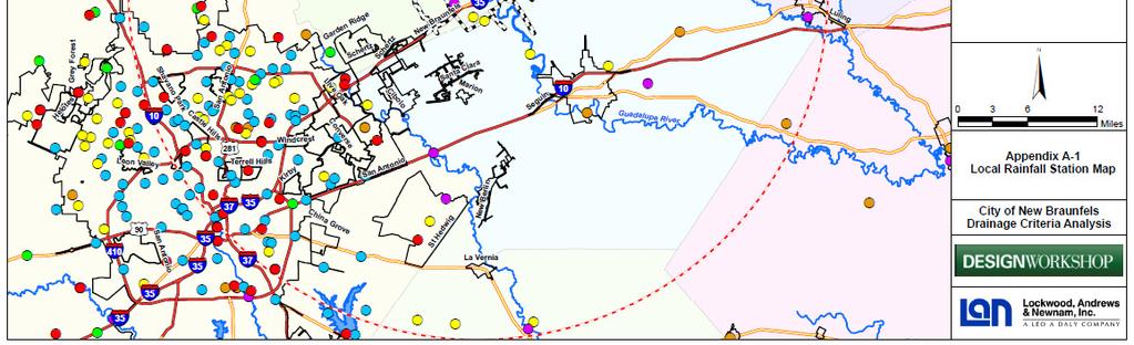
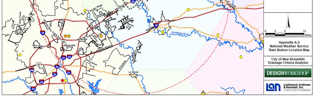
20 RAINFALL STATION MAP
21 RAIN STATION FILTER FILTER 1 = NATIONAL WEATHER SERVICE STATIONS CONSISTENT WITH USGS METHOD FILTER 2 = ACTIVE STATIONS CAPTURE RECENT STORMS FILTER 3 = RECORD LENGTH 20 YEARS LONG ENOUGH TO MINMIZE DATA SKEW FILTER 4 = WITHIN 30 MILES OF NEW BRAUNFELS RELEVANCE TO CITY

22 FILTER 1 NWS STATIONS


23 FILTER 2 ACTIVE STATIONS


24 FILTER 3 RECORD LENGTH 20 YEARS
25 FILTER 4 WITHIN 30 MILES OF NEW BRAUNFELS

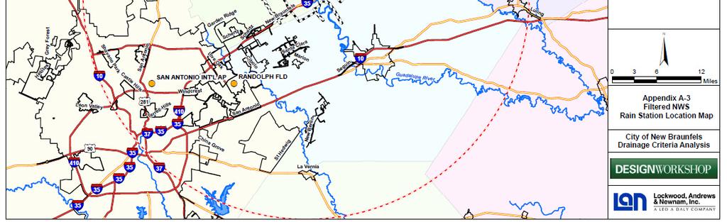
26 STATIONS USED IN ANALYSIS

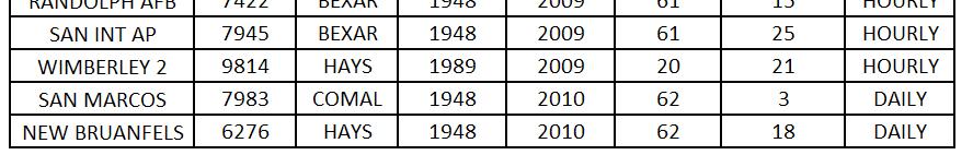
27 NWS STATIONS USED
28 DATA PROCESSING SEPARATED THE YEARS DEVELOPED ANNUAL MAXIMA HOURLY DATA USED TO GENERATE THE 1,2, 3, 6, 12, & 24-HR DEPTHS 1 HR = 1 HOURLY DATA POINT 2 HR= Σ( 2 CONSECUTIVE DATA POINTS) 3 HR= Σ( 3 CONSECUTIVE DATA POINTS) 6 HR= Σ( 6 CONSECUTIVE DATA POINTS) 12 HR= Σ( 12 CONSECUTIVE DATA POINTS) 24 HR= Σ( 24 CONSECUTIVE DATA POINTS) 48 HR= Σ( 48 CONSECUTIVE DATA POINTS) 72 HR= Σ( 72 CONSECUTIVE DATA POINTS) DAILY DATA CALCULATED SIMILAR TO HOURLY 1 DAY = 1 DAILY DATA POINT 2 DAY= Σ( 2 CONSECUTIVE DATA POINTS) 3 DAY= Σ( 3 CONSECUTIVE DATA POINTS)


29 CANYON DAM -ANNUAL MAXIMA 1 HR TO 6 HR


30 NEW BRAUNFELS -ANNUAL MAXIMA 1 DAY TO 3 DAY
 -DAILY ANNUAL MAXIMA")

31 EXTREME VALUE STATISTICS REVIEW OF (HIGHEST OR LOWEST VALUE) FROM A REOCCURING SAMPLE INTERVAL DATA -HOURLY ANNUAL MAXIMA (8,760 hr / YR) -DAILY ANNUAL MAXIMA (365 DAY / YR) INDEPENDENT RANDOM VARIABLES CLIMATE PHENOMENA SUCH AS : -RAINFALL/FLOODING -EARTHQUAKES -TEMPERATURE -DROUGHT CONGRESS BRIDGE AT COLORADO RIVER AUSTIN, TX
32 EXTREME VALUE STATISTICS
33 LOG PEARSON TYP III STREAM FLOW GUMBEL TP-40 GENERALIZED LOGISTICS (GLO) 1998 USGS 1-24 HR GENERALIZED EXTREME VALUE (GEV) 1998 USGS1-3 DAY EV- DISTRIBUTIONS
34 STANDARD MOMENTS STATISTICAL MOMENT M r = E( ( X-M ) r ) r= MOMENT ORDER (0, 1, 2, 3, 4 ) CALCULATIONS REPRESENTING THE SHAPE OF DATA PROVIDE SUMMARY COEFFICIENTS TO STATISTICAL DERIVED WITH RESPECT TO MEAN : M ( 0 ) = MEAN M ( 1 ) = VARIANCE M ( 2 ) = SKEW M ( 3 ) = KURTOSIS AVERAGE WIDTH LOPSIDEDNESS (+) = LEFT (-) = RIGHT SQUATTINESS SIMILAR TO PHYSICS: X = F(t) DISTANCE r (0) INTIAL EQUATION V = dx/dt VELOCITY r (1) 1ST ORDER A = dv/dt ACCELERATION r (2) 2ND ORDER J = da/dt JERK OR JOLT r (3)3RD ORDER
35 SIMILAR TO STANDARD MOMENTS L-MOMENT STATISTICS SUMMARY TO DATA COEFFICIENTS TO STATISTICAL DISTRIBUTIONS CALCULATED FROM FINITE SAMPLES DIFFERENT FROM STANDARD MOMENTS TAKE IN ACCOUNT DATA RANKING IN ASCENDING ORDER DERIVED WITH RESPECT TO MOMENT ORDER (NOT THE MEAN) CALCULATION INTENSIVE REQUIRING AID OF COMPUTER
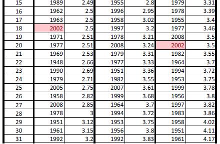
36 NEW BRAUNFELS STATION ANNUAL MAXIMA 1 DAY
37 NEW BRAUNFELS STATION ANNUAL MAXIMA 2 DAY
38 NEW BRAUNFELS STATION ANNUAL MAXIMA 3 DAY
39 PULLING THE STATIONS TOGETHER 1998 USGS STUDY FOR TEXAS 270,000 MILES USGS USED KRIGING TO PRODUCE CONTOURS USED ~850 STATIONS, GROUPED 5 AT A TIME 2011 LAN STUDY FOR NEW BRAUNFELS 30 MILES 2 RAINFALL CONTOURS NOT NEEDED SMALLER STUDY AREA THAN 1998 USGS STUDY 1, 2, 3, 6, 12-HR DURATIONS USED 7 HOURLY STATIONS 24-HR ; 2, 3-DAY DURATIONS USED 7 HOURLY & 2 DAILY STATIONS
40 DDF RESULTS 1-HR
41 DDF RESULTS 6-HR
42 DDF RESULTS 24-HR
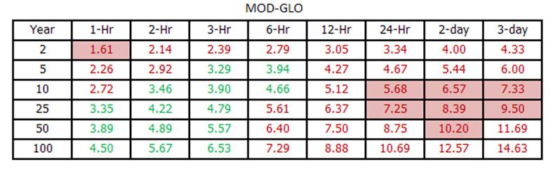
43 DDF RESULTS (PRELIMINARY)

44 DDF RESULTS (PRELIMINARY)
45 CONCLUSIONS ANALYSIS CURRENTLY UNDERGOING PEER AND CITY REVIEW DIFFERENT STATISTICAL METHODS FOR RAINFALL ESTIMATION CAN SHOW VARIED RESULTS RAINFALL VALUES FROM THE 1998 USGS STUDY COULD BE UPDATED IN AREAS WHERE EXTREME EVENTS HAVE BEEN OBSERVED
46 Q & A Definition of Statistics: The science of producing unreliable facts from reliable figures. Evan Esar Facts are stubborn, but statistics are more pliable. Mark Twain Odds of this week s satellite re-entry hurting someone in the world is estimated 1 in 3,200. Odds of any one person being struck is 1 in 21 Trillion. NASA, 9/21/11 Saul Nuccitelli, LAN, sanuccitelli@lan-inc.com
USING GIS TO MODEL AND ANALYZE HISTORICAL FLOODING OF THE GUADALUPE RIVER NEAR NEW BRAUNFELS, TEXAS
 USING GIS TO MODEL AND ANALYZE HISTORICAL FLOODING OF THE GUADALUPE RIVER NEAR NEW BRAUNFELS, TEXAS ASHLEY EVANS While the state of Texas is well-known for flooding, the Guadalupe River Basin is one of
USGS ATLAS. BACKGROUND
 USGS ATLAS. BACKGROUND 1998. Asquith. DEPTH-DURATION FREQUENCY OF PRECIPITATION FOR TEXAS. USGS Water-Resources Investigations Report 98 4044. Defines the depth-duration frequency (DDF) of rainfall annual
Another 100-Year Storm. October 26, 2016 Mark Dennis, PE, CFM
 Another 100-Year Storm October 26, 2016 Mark Dennis, PE, CFM Agenda Are severe rainfall events becoming more frequent? Is there confusion about the 100-year storm that makes it seem like they happen all
The Beleaguered Figure 15
 The Beleaguered Figure 15 TFMA 2015 Fall Technical Summit After the Floods: Texas Rising Craig Loftin, PE, CFM US Weather Bureau Technical Paper No. 40, Figure 15 Village Creek Watershed 1 100-Year 30-Minute
The Beleaguered Figure 15 TFMA 2015 Fall Technical Summit After the Floods: Texas Rising
 The Beleaguered Figure 15 TFMA 2015 Fall Technical Summit After the Floods: Texas Rising Craig Loftin, PE, CFM US Weather Bureau Technical Paper No. 40, Figure 15 Village Creek Watershed 100-Year 30-Minute
Near Real-Time Runoff Estimation Using Spatially Distributed Radar Rainfall Data. Jennifer Hadley 22 April 2003
 Near Real-Time Runoff Estimation Using Spatially Distributed Radar Rainfall Data Jennifer Hadley 22 April 2003 Introduction Water availability has become a major issue in Texas in the last several years,
LITERATURE REVIEW. History. In 1888, the U.S. Signal Service installed the first automatic rain gage used to
 LITERATURE REVIEW History In 1888, the U.S. Signal Service installed the first automatic rain gage used to record intensive precipitation for short periods (Yarnell, 1935). Using the records from this
NRC Workshop - Probabilistic Flood Hazard Assessment Jan 2013
 Regional Precipitation-Frequency Analysis And Extreme Storms Including PMP Current State of Understanding/Practice Mel Schaefer Ph.D. P.E. MGS Engineering Consultants, Inc. Olympia, WA NRC Workshop - Probabilistic
An Alternative Temporal Rainfall Distribution for Hydrologic Analysis and Design
 An Alternative Temporal Rainfall Distribution for Hydrologic Analysis and Design Joseph P. Wilson, PE, PH Wilson Hydro, LLC PhD Candidate Missouri University of Science Technology Rolla, Missouri Sorry
USSD Conference, Denver 2016
 USSD Conference, Denver 2016 M Schaefer, MGS Engineering Consultants K Neff, TVA River Operations C Jawdy, TVA River Operations S Carney, Riverside Technology B Barker, MGS Engineering Consultants G Taylor,
Precipitation Intensity-Duration- Frequency Analysis in the Face of Climate Change and Uncertainty
 Precipitation Intensity-Duration- Frequency Analysis in the Face of Climate Change and Uncertainty Supporting Casco Bay Region Climate Change Adaptation RRAP Eugene Yan, Alissa Jared, Edom Moges Environmental
Intensity-Duration-Frequency (IDF) Curves Example
 Curves Example") Intensity-Duration-Frequency (IDF) Curves Example Intensity-Duration-Frequency (IDF) curves describe the relationship between rainfall intensity, rainfall duration, and return period (or its inverse, probability
Intensity-Duration-Frequency (IDF) Curves Example Intensity-Duration-Frequency (IDF) curves describe the relationship between rainfall intensity, rainfall duration, and return period (or its inverse, probability
Updated Precipitation Frequency Estimates for Minnesota
 1 Updated Precipitation Frequency Estimates for Minnesota Presenter: Authors: (alphabetical order) Sanja Perica, Director Hydrometeorological Design Studies Center (HDSC), Office of Hydrology, National
Results of Intensity-Duration- Frequency Analysis for Precipitation and Runoff under Changing Climate
 Results of Intensity-Duration- Frequency Analysis for Precipitation and Runoff under Changing Climate Supporting Casco Bay Region Climate Change Adaptation RRAP Eugene Yan, Alissa Jared, Julia Pierce,
Areal Reduction Factors for the Colorado Front Range and Analysis of the September 2013 Colorado Storm
 Areal Reduction Factors for the Colorado Front Range and Analysis of the September 2013 Colorado Storm Doug Hultstrand, Bill Kappel, Geoff Muhlestein Applied Weather Associates, LLC - Monument, Colorado
Due: Monday November 26 th LAB 7: Rivers and Flood Frequency
 1 12.001 Due: Monday November 26 th LAB 7: Rivers and Flood Frequency Overview and Objectives This exercise will provide some hands-on experience with methods used for predicting flood frequency and magnitude.
Areal Reduction Factors for the Colorado Front Range and Analysis of the September 2013 Colorado Storm
 Areal Reduction Factors for the Colorado Front Range and Analysis of the September 2013 Colorado Storm Doug Hultstrand, Bill Kappel, Geoff Muhlestein Applied Weather Associates, LLC - Monument, Colorado
Leon Creek Watershed October 17-18, 1998 Rainfall Analysis Examination of USGS Gauge Helotes Creek at Helotes, Texas
 Leon Creek Watershed October 17-18, 1998 Rainfall Analysis Examination of USGS Gauge 8181400 Helotes Creek at Helotes, Texas Terrance Jackson MSCE Candidate University of Texas San Antonio Abstract The
Rick Faber CE 513 Building a Base Map Lab #2 6/2/06
 Rick Faber CE 513 Building a Base Map Lab #2 6/2/06 1. Objective & Discussion: By using data for the Guadalupe river basin in Texas, we will get a chance to build a base map of hydrologic features. These
SUPPLEMENTARY INFORMATION
 SUPPLEMENTARY INFORMATION Supplementary Information Rapid formation of a modern bedrock canyon by a single flood event Michael P. Lamb 1 and Mark A. Fonstad 2 1 California Institute of Technology, Geological
David R. Vallee Hydrologist-in-Charge NOAA/NWS Northeast River Forecast Center
 David R. Vallee Hydrologist-in-Charge NOAA/NWS Northeast River Forecast Center Record flooding along the Shawsheen River during the 2006 Mother s Day Floods Calibrate and implement a variety of hydrologic
Typical Hydrologic Period Report (Final)
") (DELCORA) (Final) November 2015 (Updated April 2016) CSO Long-Term Control Plant Update REVISION CONTROL REV. NO. DATE ISSUED PREPARED BY DESCRIPTION OF CHANGES 1 4/26/16 Greeley and Hansen Pg. 1-3,
(DELCORA) (Final) November 2015 (Updated April 2016) CSO Long-Term Control Plant Update REVISION CONTROL REV. NO. DATE ISSUED PREPARED BY DESCRIPTION OF CHANGES 1 4/26/16 Greeley and Hansen Pg. 1-3,
Napa Watershed Water Year Classification Methodology 1
 Napa Watershed Water Year Classification Methodology 1 Methodology to Classify Water Years An online data management and reporting platform ITAS) is being created for the Napa River Watershed to track
San Antonio River Authority. San Antonio River Authority Floodworks implementation in the San Antonio River Basin. Nefi Garza, PE, CFM
 San Antonio River Authority Floodworks implementation in the San Antonio River Basin Nefi Garza, PE, CFM San Antonio River Authority Michael Crenshaw, PE, CFM Anthony J. Henry Wallingford Software, Inc
Recurrence Interval for the 2006 Flood Delaware and Otsego County, New York
 Recurrence Interval for the 2006 Flood Delaware and Otsego County, New York Les Hasbargen Dept. of Earth Sciences SUNY Oneonta Ouleout Creek, flood scars Picture From : http://www.co.delaware.ny.us/flood_2006/crop%20&%20land%20photos/default.htm
CoCoRaHS Monitoring Colorado s s Water Resources through Community Collaborations
 CoCoRaHS Monitoring Colorado s s Water Resources through Community Collaborations Nolan Doesken Colorado Climate Center Atmospheric Science Department Colorado State University Presented at Sustaining
Detailed Storm Rainfall Analysis for Hurricane Ivan Flooding in Georgia Using the Storm Precipitation Analysis System (SPAS) and NEXRAD Weather Radar
 and NEXRAD Weather Radar") Detailed Storm Rainfall Analysis for Hurricane Ivan Flooding in Georgia Using the Storm Precipitation Analysis System (SPAS) and NEXRAD Weather Radar Ed Tomlinson, PhD and Bill Kappel Applied Weather Associates
Detailed Storm Rainfall Analysis for Hurricane Ivan Flooding in Georgia Using the Storm Precipitation Analysis System (SPAS) and NEXRAD Weather Radar Ed Tomlinson, PhD and Bill Kappel Applied Weather Associates
Changes to Extreme Precipitation Events: What the Historical Record Shows and What It Means for Engineers
 Changes to Extreme Precipitation Events: What the Historical Record Shows and What It Means for Engineers Geoffrey M Bonnin National Oceanic and Atmospheric Administration National Weather Service Office
President s Day Weekend Storm Community Meeting and Workshop April 17, 2017
 President s Day Weekend Storm Community Meeting and Workshop April 17, 2017 Meeting outline 1. Progress update on the City of San Jose s recovery efforts 2. Water district presentation on: Weather situation
Talk Overview. Concepts. Climatology. Monitoring. Applications
 Atmospheric Rivers Talk Overview Concepts Climatology Monitoring Applications Satellite View Where is the storm? Where is the impact? Atmospheric Rivers Plume or fire hose of tropical moisture Heavy precipitation
INFLOW DESIGN FLOOD CONTROL SYSTEM PLAN 40 C.F.R. PART PLANT YATES ASH POND 2 (AP-2) GEORGIA POWER COMPANY
 GEORGIA POWER COMPANY") INFLOW DESIGN FLOOD CONTROL SYSTEM PLAN 40 C.F.R. PART 257.82 PLANT YATES ASH POND 2 (AP-2) GEORGIA POWER COMPANY EPA s Disposal of Coal Combustion Residuals from Electric Utilities Final Rule (40 C.F.R.
INFLOW DESIGN FLOOD CONTROL SYSTEM PLAN 40 C.F.R. PART 257.82 PLANT YATES ASH POND 2 (AP-2) GEORGIA POWER COMPANY EPA s Disposal of Coal Combustion Residuals from Electric Utilities Final Rule (40 C.F.R.
ENGINEERING HYDROLOGY
 ENGINEERING HYDROLOGY Prof. Rajesh Bhagat Asst. Professor Civil Engineering Department Yeshwantrao Chavan College Of Engineering Nagpur B. E. (Civil Engg.) M. Tech. (Enviro. Engg.) GCOE, Amravati VNIT,
Flood Event Analysis to Estimate the Avoided Damages Due to Flood Improvement Projects & Voluntary Buyout Program
 Flood Event Analysis to Estimate the Avoided Damages Due to Flood Improvement Projects & Voluntary Buyout Program Ataul Hannan, P.E., CFM Planning Division Director Harris County Flood Control District
REDWOOD VALLEY SUBAREA
 Independent Science Review Panel Conceptual Model of Watershed Hydrology, Surface Water and Groundwater Interactions and Stream Ecology for the Russian River Watershed Appendices A-1 APPENDIX A A-2 REDWOOD
Probable Maximum Precipitation Study
 Probable Maximum Precipitation Study Virginia Floodplain Management Association Workshop Thursday, October 29, 2015 Robert T. Bennett, PE, RA, CFM DCR Dam Safety & Floodplain Management Definition (4VAC50-20-50.H)
Extreme Rain all Frequency Analysis for Louisiana
 78 TRANSPORTATION RESEARCH RECORD 1420 Extreme Rain all Frequency Analysis for Louisiana BABAK NAGHAVI AND FANG XIN Yu A comparative study of five popular frequency distributions and three parameter estimation
Extreme Precipitation, NOAA Atlas 14, Other InFRM Initiatives What Can You Do?
 Extreme Precipitation, NOAA Atlas 14, Other InFRM Initiatives What Can You Do? Date: 19 September2018 Audience: TX Civil Engineering Conference, San Marcos, TX Jerry L. Cotter P.E., Chief Water Resources
Section 4: Model Development and Application
 Section 4: Model Development and Application The hydrologic model for the Wissahickon Act 167 study was built using GIS layers of land use, hydrologic soil groups, terrain and orthophotography. Within
Changing Climate. An Engineering challenge for today and the future. Milwaukee School of Engineering December 2, 2015
 Changing Climate An Engineering challenge for today and the future David S. Liebl UW- Madison, EPD; UW-Extension; Wisconsin Initiative on Climate change Impacts Milwaukee School of Engineering December
United States Multi-Hazard Early Warning System
 United States Multi-Hazard Early Warning System Saving Lives Through Partnership Lynn Maximuk National Weather Service Director, Central Region Kansas City, Missouri America s s Weather Enterprise: Protecting
Flooding. April 21, Notes 4/20 CONGRATULATIONS!!!!! Activity 2: AZ State Museum due TODAY. Extra Credit 2: Returned at end of class
 April 21, 2011 Flooding 1927 Mississippi Flood Notes 4/20 Activity 2: AZ State Museum due TODAY Extra Credit 2: Returned at end of class CONGRATULATIONS!!!!! Andrew Richard Undergraduate Research Grant
Valenciano Reservoir Safe Yield Study. Prepared by: CSA Architects & Engineers, LLP
 Valenciano Reservoir Safe Yield Study Prepared by: CSA Architects & Engineers, LLP CSA Group Prepared for: Puerto Rico Aqueduct and Sewer Authority Planning TABLE OF CONTENTS 1 Introduction...1 1.1 Safe
Village Weather, Snow, Ice, Breakup, Flooding, Fire sites
 Village Weather, Snow, Ice, Breakup, Flooding, Fire sites What is the weather like now in Villages?... 1 BREAKUP:... 2 Flooding... 3 Fires... 5 Weather Predictability, Weather and Ice Advisories and How
Rainfall-Flood Hazard along the Cagayan River in Carmen
 -Flood Hazard along the Cagayan River in Carmen Things to watch out for when rain falls intensity 12 December 2013, Cagayan de Oro City Hall 3 +1 main questions I What do we need to understand about rainfall
New design rainfalls. Janice Green, Project Director IFD Revision Project, Bureau of Meteorology
 New design rainfalls Janice Green, Project Director IFD Revision Project, Bureau of Meteorology Design Rainfalls Design Rainfalls Severe weather thresholds Flood forecasting assessing probability of rainfalls
New NOAA Precipitation-Frequency Atlas for Wisconsin
 New NOAA Precipitation-Frequency Atlas for Wisconsin #215966 Presentation to the Milwaukee Metropolitan Sewerage District Technical Advisory Team January 16, 2014 Michael G. Hahn, P.E., P.H. SEWRPC Chief
Recurrence Intervals for the June 2006 Flood in Delaware and Otsego counties, New York
 Recurrence Intervals for the June 2006 Flood in Delaware and Otsego counties, New York Earth Sciences Brown Bag Seminar Spring 2008 Les Hasbargen Dept. of Earth Sciences SUNY Oneonta Ouleout Creek, flood
High Rainfall Events and Their Changes in the Hawaiian Islands
 High Rainfall Events and Their Changes in the Hawaiian Islands Pao-Shin Chu, Xin Zhao, Melodie Grubbs, Cheri Loughran, and Peng Wu Hawaii State Climate Office Department of Meteorology School of Ocean
5/4/2017 Fountain Creek. Gage Analysis. Homework 6. Clifton, Cundiff, Pour, Queen, and Zey CIVE 717
 5/4/2017 Fountain Creek Gage Analysis Homework 6 Clifton, Cundiff, Pour, Queen, and Zey CIVE 717 Introduction: The CIVE 717 class members, Nate Clifton, Susan Cundiff, Ali Reza Nowrooz Pour, Robbie Queen
A Comparative Study of the National Water Model Forecast to Observed Streamflow Data
 A Comparative Study of the National Water Model Forecast to Observed Streamflow Data CE394K GIS in Water Resources Term Project Report Fall 2018 Leah Huling Introduction As global temperatures increase,
A Synopsis of the December 1-4, 2007 Storm Events
 A Synopsis of the December 1-4, 27 Storm Events An aerial view of the flooded I-5 overpass looking south Flooding in Chehalis. (Associated Press ) Maryanne Reiter, Hydrologist Weyerhaeuser Co. The Wind
Floods Lecture #21 20
 Floods 20 Lecture #21 What Is a Flood? Def: high discharge event along a river! Due to heavy rain or snow-melt During a flood, a river:! Erodes channel o Deeper & wider! Overflows channel o Deposits sediment
Lecture 14: Floods. Key Questions
 Lecture 14: Floods Key Questions 1. What is an upstream flood? 2. What is a downstream flood? 3. What were the setup conditions that cause floods? 4. What is a 100-year flood? 5. How are 100-year flood
Storm Report: January 27, 2008 Maricopa County, AZ
 Storm Report: January 27, 2008 Maricopa County, AZ Engineering Division, Flood Warning Branch TABLE OF CONTENTS Meteorology...2 Precipitation...4 Runoff...9 ALERT System Alarms...12 TABLES Table 1 Summary
Hydrologic Evaluation of the Blanchard River
 Hydrologic Evaluation of the Blanchard River Hancock County Flood Risk Reduction Program Prepared for: Maumee Watershed Conservancy District 1464 Pinehurst Dr. Defiance, Ohio 43512 Prepared by: Stantec
Watershed Detectives:
 Watershed Detectives: Making Science Relevant Jessica Gordon City of Austin Watershed Protection Jessica.Gordon@austintexas.gov Watershed Detectives: Making Science Relevant The Fish Kill Mystery Austin-based,
Precipitation Extremes in the Hawaiian Islands and Taiwan under a changing climate
 Precipitation Extremes in the Hawaiian Islands and Taiwan under a changing climate Pao-Shin Chu Department of Atmospheric Sciences University of Hawaii-Manoa Y. Ruan, X. Zhao, D.J. Chen, and P.L. Lin December
Technical Memorandum No RAINFALL
 Pajaro River Watershed Study in association with Technical Memorandum No. 1.2.2 RAINFALL Task: Collection and Analysis of Rainfall Data To: PRWFPA Staff Working Group Prepared by: J. Schaaf Reviewed by:
High intensity rainfall estimation in New Zealand
 Water New Zealand 31 st October 2013 High intensity rainfall estimation in New Zealand Graeme Horrell Engineering Hydrologist, Contents High Intensity Rainfall Design System (HIRDS Version 1) HIRDS Version
Flooding in Western North Carolina: Some Spatial, Hydrologic, and Seasonal Characteristics CAUTION!! Outline. Basic Flood Facts.
 Flooding in Western North Carolina: Some Spatial, Hydrologic, and Seasonal Characteristics J. Greg Dobson CAUTION!! National Environmental Modeling and Analysis Center RENCI at UNC-Asheville Engagement
Ecological Context - Urban settlements are part of their surrounding ecosystem. Austin
 Ecological Context - Urban settlements are part of their surrounding ecosystem Austin Ecotone Division between West and East Flyway Uplift River Balcones Escarpment Central Texas Climate The principal
FORECAST-BASED OPERATIONS AT FOLSOM DAM AND LAKE
 FORECAST-BASED OPERATIONS AT FOLSOM DAM AND LAKE 255 237 237 237 217 217 217 200 200 200 0 163 131 Bridging the Gap163Conference 255 0 132 255 0 163 122 The Dana on Mission Bay San Diego, CA January 28,
Overview of a Changing Climate in Rhode Island
 Overview of a Changing Climate in Rhode Island David Vallee, Hydrologist in Charge, National Weather Service Northeast River Forecast Center, NOAA Lenny Giuliano, Air Quality Specialist, Rhode Island Department
Recent development of the National Hydro-Meteorological Service (NHMS) of Viet Nam for disaster risk reduction
 of Viet Nam for disaster risk reduction") Ministry of Natural Resources and Environment National Hydro-Meteorological Service Recent development of the National Hydro-Meteorological Service (NHMS) of Viet Nam for disaster risk reduction Tran Van
Ministry of Natural Resources and Environment National Hydro-Meteorological Service Recent development of the National Hydro-Meteorological Service (NHMS) of Viet Nam for disaster risk reduction Tran Van
FEMA Hazards Loss Modeling Task Force (MOTF) Situation Report #14. Colorado Spring Flood Risk ***FINAL REPORT***
 Situation Report #14. Colorado Spring Flood Risk ***FINAL REPORT***") FEMA Hazards Loss Modeling Task Force (MOTF) Situation Report #14 Colorado Spring Flood Risk FEMA Modeling Task Force (MOTF) Denver Federal Center, Building 710A Denver, Colorado 80225 Email: FEMA-MOTF@fema.dhs.gov
FEMA Hazards Loss Modeling Task Force (MOTF) Situation Report #14 Colorado Spring Flood Risk FEMA Modeling Task Force (MOTF) Denver Federal Center, Building 710A Denver, Colorado 80225 Email: FEMA-MOTF@fema.dhs.gov
CASE STUDY #9 - Brushy Fork Dam, Sugar Grove, West Virginia
 CASE STUDY #9 - Brushy Fork Dam, Sugar Grove, West Virginia Brushy Fork Dam is a flood control structure built by the Soil Conservation Service southeast of the city of Franklin in Pendleton County, West
Model Calibration and Forecast Error for NFIE-Hydro
 Corey Van Dyk C E 397 Flood Forecasting 5/8/15 Model Calibration and Forecast Error for NFIE-Hydro Introduction The forecasting component of the National Flood Interoperability Experiment (NFIE), like
Groundwater dynamics and surface water-groundwater interaction in a prograding delta island, Louisiana, USA
 Supplementary Information Groundwater dynamics and surface water-groundwater interaction in a prograding delta island, Louisiana, USA Michael T. O Connor 1* and Kevan B. Moffett 1,2 1 Department of Geological
6/9/2014. Software Overview. System Overview
 Future Rainfall 6/9/2014 Curtis Beitel, PE, CFM, Anthony Henry and Wayne Tschirhart, PE, CFM, PMP TFMA Spring 2014 Conference Software Overview 2 Processes Hydrometric DB Event Manager Automatic Low =
PLANNED UPGRADE OF NIWA S HIGH INTENSITY RAINFALL DESIGN SYSTEM (HIRDS)
") PLANNED UPGRADE OF NIWA S HIGH INTENSITY RAINFALL DESIGN SYSTEM (HIRDS) G.A. Horrell, C.P. Pearson National Institute of Water and Atmospheric Research (NIWA), Christchurch, New Zealand ABSTRACT Statistics
PLANNED UPGRADE OF NIWA S HIGH INTENSITY RAINFALL DESIGN SYSTEM (HIRDS) G.A. Horrell, C.P. Pearson National Institute of Water and Atmospheric Research (NIWA), Christchurch, New Zealand ABSTRACT Statistics
CENTRAL TEXAS HILL COUNTRY FLOOD
 CENTRAL TEXAS HILL COUNTRY FLOOD Term project report DECEMBER 7, 2018 UNIVERSITY OF TEXAS AT AUSTIN CE394K: GIS in Water Resources Engineering RIFAAI Mohamed Talha Table of Contents Introduction... 3 Context...
Chapter 5 CALIBRATION AND VERIFICATION
 Chapter 5 CALIBRATION AND VERIFICATION This chapter contains the calibration procedure and data used for the LSC existing conditions model. The goal of the calibration effort was to develop a hydraulic
QUANTITY, MARCH 1962
 BASE-FLOW STUDIES, GUADALUPE RIVER COMAL COUNTY, TEXAS QUANTITY, MARCH 1962 TEXAS WATER COMMISSION BULLETIN 6503 MARCH 1965 TEXAS WATER COMMISSION Joe William D E 0. F. Dent Carter, Chairman Berger, Commissioner
Pompton Lakes Dam Downstream Effects of the Floodgate Facility. Joseph Ruggeri Brian Cahill Michael Mak Andy Bonner
 Pompton Lakes Dam Downstream Effects of the Joseph Ruggeri Brian Cahill Michael Mak Andy Bonner ASFPM 2013: Overview Page 2 Overview Page 3 Overview Page 4 Overview Page 5 Overview - Historical Pompton
National Weather Service Flood Forecast Needs: Improved Rainfall Estimates
 National Weather Service Flood Forecast Needs: Improved Rainfall Estimates Weather Forecast Offices Cleveland and Northern Indiana Ohio River Forecast Center Presenter: Sarah Jamison, Service Hydrologist
Delaware River Flood Advisory Committee
 Delaware River Flood Advisory Committee A Partnership to Support Flood Mitigation Alan Tamm Pennsylvania Emergency Management Agency Bureau of Recovery and Mitigation atamm@state.pa.us Peter Gabrielsen
Flood and emergency preparedness CARNATION DUVALL CITIZEN CORPS DUVALL KING COUNTY FIRE DISTRICT 45 SEPTEMBER 11, 2018
 Flood and emergency preparedness CARNATION DUVALL CITIZEN CORPS DUVALL KING COUNTY FIRE DISTRICT 45 SEPTEMBER 11, 2018 Let s get started Important info! Presenters Kathy Brasch, Carnation-Duvall Citizen
Rainwater Harvesting in Austin, TX Sarah Keithley University of Texas at Austin
 Rainwater Harvesting in Austin, TX Sarah Keithley University of Texas at Austin 1 Abstract Rainwater harvesting, the collection of rainwater from a roof catchment, is an alternative water resource and
A Cloud-Based Flood Warning System For Forecasting Impacts to Transportation Infrastructure Systems
 A Cloud-Based Flood Warning System For Forecasting Impacts to Transportation Infrastructure Systems Jon Goodall Associate Professor, Civil and Environmental Engineering Associate Director, Link Lab April
SAMPLE. SITE SPECIFIC WEATHER ANALYSIS Rainfall Report. Bevins Engineering, Inc. Susan M. Benedict. July 1, 2017 REFERENCE:
 SAMPLE SITE SPECIFIC WEATHER ANALYSIS Rainfall Report PREPARED FOR: Bevins Engineering, Inc. Susan M. Benedict July 1, 2017 REFERENCE: DUBOWSKI RESIDENCE / FILE# 11511033 1500 Water Street, Pensacola,
Lecture 2: Precipitation
 2-1 GEOG415 Lecture 2: Precipitation Why do we study precipitation? Precipitation measurement -- depends on the study purpose. Non-recording (cumulative) Recording (tipping bucket) Important parameters
Application of Satellite Data for Flood Forecasting and Early Warning in the Mekong River Basin in South-east Asia
 MEKONG RIVER COMMISSION Vientiane, Lao PDR Application of Satellite Data for Flood Forecasting and Early Warning in the Mekong River Basin in South-east Asia 4 th World Water Forum March 2006 Mexico City,
ESTIMATING JOINT FLOW PROBABILITIES AT STREAM CONFLUENCES USING COPULAS
 ESTIMATING JOINT FLOW PROBABILITIES AT STREAM CONFLUENCES USING COPULAS Roger T. Kilgore, P.E., D. WRE* Principal Kilgore Consulting and Management 2963 Ash Street Denver, CO 80207 303-333-1408 David B.
Storm Report : September 27, 2014
 True-color Visible Satellite, Sep. 27, 2014 2:00 PM MST Flood Control District of Maricopa County Engineering Division, Flood Warning Branch Storm Report : September 27, 2014 Initial Release: 10/10/2014
Hydrology and Hydraulics Design Report. Background Summary
 To: National Park Services Montezuma Castle National Monument Richard Goepfrich, Facility Manager From: Multicultural Technical Engineers Date: Tuesday - February 13, 2018 Subject: 30% Hydrology and Hydraulics
5.2 IDENTIFICATION OF HAZARDS OF CONCERN
 5.2 IDENTIFICATION OF HAZARDS OF CONCERN 2016 HMP Update Changes The 2011 HMP hazard identification was presented in Section 3. For the 2016 HMP update, the hazard identification is presented in subsection
The Stochastic Event Flood Model Applied to Minidoka Dam on the Snake River, Idaho
 The Stochastic Event Flood Model Applied to Minidoka Dam on the Snake River, Idaho K. L. Bullard 1, M. G. Schaeffer 2, B. A. Barker 3, D. Sutley 4, and V. Leverson 5 1 Bureau of Reclamation, Flood Hydrology
2016 Fall Conditions Report
 2016 Fall Conditions Report Prepared by: Hydrologic Forecast Centre Date: December 13, 2016 Table of Contents TABLE OF FIGURES... ii EXECUTIVE SUMMARY... 1 BACKGROUND... 5 SUMMER AND FALL PRECIPITATION...
Analysis of Tides and Storm Surge from Observational Records in the Delaware Inland Bays
 Analysis of Tides and Storm Surge from Observational Records in the Delaware Inland Bays John Callahan Delaware Geological Survey Coastal GeoTools Conference March 30 April 2, 2015 Charleston, SC Outline
Rainfall Observations in the Loxahatchee River Watershed
 Rainfall Observations in the Loxahatchee River Watershed Richard C. Dent Loxahatchee River District September 1997 Introduction Rain is a common occurrence in south Florida, yet its presence or absence
USGS Flood Inundation Mapping of the Suncook River in Chichester, Epsom, Pembroke and Allenstown, New Hampshire
 USGS Flood Inundation Mapping of the Suncook River in Chichester, Epsom, Pembroke and Allenstown, New Hampshire NH Water & Watershed Conference Robert Flynn, USGS NH-VT Water Science Center March 23, 2012
Summer 2007 Flood Report
 Summer 2007 Flood Report LCRA Water Services River Operations Center NEXRAD image of the June 27 storm that triggered the Summer 2007 Flood Executive Summary Flood Facts: The Summer 2007 Flood was unexpected,
Final Report. COMET Partner's Project. University of Texas at San Antonio
 Final Report COMET Partner's Project University: Name of University Researcher Preparing Report: University of Texas at San Antonio Dr. Hongjie Xie National Weather Service Office: Name of National Weather
ARMSTRONG COUNTY, PA
 ARMSTRONG COUNTY, PA Revised Preliminary DFIRM Mapping March 31, 2013 Kevin Donnelly, P.E., CFM GG3, Greenhorne & O Mara, Inc. Presentation Agenda Armstrong County DFIRM Overview - June 25, 2010 DFIRM
Design Storms for Hydrologic Analysis
 Design Storms for Hydrologic Analysis Course Description This course is designed to fulfill two hours of continuing education credit for Professional Engineers. Its objective is to provide students with
Welcome Jeff Orrock Warning Coordination Meteorologist National Weather Service Raleigh
 Welcome Jeff Orrock Warning Coordination Meteorologist National Weather Service Raleigh Jeff.orrock@noaa.gov Sources: Operational Significant Event Imagery and the Environmental Applications Team (EAT)
David R. Vallee Hydrologist-in-Charge NOAA/NWS Northeast River Forecast Center
 Flooding along the Housatonic River following Tropical Storm Lee, Sept 8, 2011. Photo: A. Driscoll, Connecticut Post David R. Vallee Hydrologist-in-Charge NOAA/NWS Northeast River Forecast Center Examining
Unlined Spillway Erosion Risk Assessment
 Unlined Spillway Erosion Risk Assessment Johannes Wibowo Don Yule Evelyn Villanueva U.S. Army COE ERDC Darrel Temple USDA Tuttle Creek, KS Introduction Canyon Dam Spillway, Texas Date: July 6, 2002 Flow:
Christopher ISU
 Christopher Anderson @ ISU Excessive spring rain will be more frequent (except this year). Will it be more manageable? Christopher J. Anderson, PhD 89th Annual Soil Management and Land Valuation Conference
Seeley Burn Scar SR-31, Region 4 UDOT Weather Response Summer 2013
 Seeley Burn Scar SR-31, Region 4 UDOT Weather Response Summer 2013 Seeley Burn Scar Information June 26 July 18, 2012 48,050 acres burned Lightning caused fire 8 miles of SR-31 impacted Huntington Creek