USGS ATLAS. BACKGROUND
|
|
|
- Vivian White
- 6 years ago
- Views:
Transcription
1 USGS ATLAS. BACKGROUND Asquith. DEPTH-DURATION FREQUENCY OF PRECIPITATION FOR TEXAS. USGS Water-Resources Investigations Report Defines the depth-duration frequency (DDF) of rainfall annual maxima in Texas by providing an atlas of the parameters of probability distributions. Many TxDOT Design engineers have had greater-than-expected difficulty implementing the procedures The difficulty has delayed the implementation of the new precipitation data.. develop a simple-to-use atlas of the updated precipitation depths in Texas for selected values of storm duration and frequency. (From TxDOT Implementation Status, Project Summary Report S) Asquith and Roussel. ATLAS OF DEPTH-DURATION FREQUENCY OF PRECIPITATION ANNUAL MAXIMA FOR TEXAS. USGS Scientific Investigations Report Provides a directly interpretable atlas of DDF in Texas on the basis of research results of Asquith (1998). The report contains 96 maps of the depth of rainfall for 12 storm durations and 8 annual nonexceedance probabilities (recurrence intervals). GOALS: improve ease of use; resolve inconsistencies in estimates Data not updated for this project; in some areas regionalization done differently; at 1-day GEV replaced GLO Asquith, Roussel, Cleveland, Fang,and Thompson. Statistical characteristics of storm interevent time, depth, and duration for eastern New Mexico, Oklahoma, and Texas. USGS Professional Paper S. Perica 04/17/2014


2 FINAL PRODUCTS UNDERLYING DATA FREQUENCY ANALYSIS TECHNIQUES S. Perica 04/17/2014
3 1. AVAILABLE PRODUCTS S. Perica 04/17/2014

4 USGS ATLAS. Cartographic maps

5 NA14. Cartographic maps Maps were created as visual aids and are not recommended for interpolating estimates.
6 19. NA 14. Underlying data PFDS operates from a set of ASCII grids (30-arc sec resolution) USGS project coverage Duration Average recurrence interval (ARI) ,000 5-min 10-min 15-min 30-min 60-min 2-hour 3-hour 6-hour 12-hour 24-hour 2-day 3-day 4-day 7-day 10-day 20-day 30-day 45-day 60-day
7 NA14. Precipitation frequency estimates in GIS compatible format (30 arc-sec resolution) PDS: 570 grids (190 quantile; 190 upper CL; 190 lower CL) AMS: 513 grids (171 quantile; 171 upper CL; 171 lower CL)

8 Initial display NA 14. PF estimates for a single location

9 NA14. Zooming in...

10 NA14....retrieving PF estimate with confidence limits

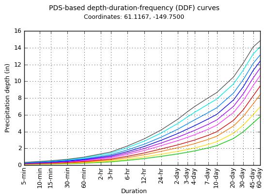

11 . NA 14. DDF curves, confidence intervals plots
12 . NA 14. Additional products Temporal distributions Seasonality analysis Rainfall (liquid precipitation) frequency estimates Annual maximum series data for a range of durations Related documentation Link to relevant NCDC climate data and EPA watershed information COMING SOON: Regional Areal-Reduction-Factors calculated on-fly for any delineated area
13 2. DATA S. Perica 04/17/2014
14 Data collection USGS: NWS dataset NOAA, National Climatic Data Center (NCDC) NA14: various sources (40 agencies for MWSE; 24 agencies for NE) NOAA, National Climatic Data Center (NCDC) Boston Water and Sewer Commission Earth Networks Environment Canada Illinois State Water Survey: National Atmospheric Deposition Program (NADP) Mid-Atlantic River Forecast Center: Integrated Flood Observing and Warning System (IFLOWS) data Midwestern Region Climate Center (MRCC): 19th Century Forts and Voluntary Observers Database Automated Surface Observing Systems (ASOS) Colorado Climate Center: (CoCoRaHS) Mount Washington Observatory NCDC: U.S. Climate Reference Network (USCRN) National Resources Conservation Service (NRCS): Soil Climate Analysis Network (SCAN) New Hampshire Department of Transportation Office of the New Jersey State Climatologist at Rutgers University: NJ Mesonet U.S. Department of Agriculture: Agricultural Research Service (ARS) U.S. Forest Service: Remote Automated Weather Stations (RAWS) dataset USGS Water Science Centers U.S. Army Corps of Engineers local offices New York City Department of Environmental Protection (NYCDEP)... S. Perica 04/17/2014
15 Record lengths Record length USGS: Data for 1998 USGS study go up to NA14: Potentially more than 20 more years of data available at each station; More stations pass minimum data years requirement nyears criteria USGS: nyears > 9 NA14: nyears > 29 (with some exceptions) S. Perica 04/17/2014
16 3. FREQUENCY ANALYSIS METHODS USGS: AMS-based regional frequency analysis approach based on L-moment statistics NA14: AMS-based regional frequency analysis approach based on L-moment statistics S. Perica 04/17/2014

 USGS NA14 S.")
17 ARI vs AEP AMS: Annual exceedance probability PDS: Average recurrence interval (return period) USGS NA14 S. Perica 04/17/2014
")
18 AMS quality control USGS? NA14: QC done for all durations; high and low outliers 7/27/1949 (+/- 1day) Example: Royalton 5W ( ), 1-day (NCDC station)

: 100 years 12 in 18 in 1000 years 13")
19 AMS QC - Low outlier example With low outlier Precipitation frequency estimate With low outlier Without low outlier Without low outlier for ARI (T): 100 years 12 in 18 in 1000 years 13 in 26 in

20 Derivation of regional L-moments USGS: 5 (closest?) stations NA14:
21 Distribution selection and fitting USGS: GLO for 15min 24hr; GEV for 1day 7 day (1998) GLO for 15min 12hr; GEV for other durations (2004) NA14: GEV for all durations Precipitation (in) Distribution: Generalized Logistic Generalized Normal Generalized Pareto Pearson Type III Kappa Wakeby Generalized Extreme Value ARI (years) Potential PF range in in Annual exceedance probability (%)
22 At-station DDF curves consistency check USGS: consistency checked in 2004 study NA14: constrained optimization used to adjust inconsistencies 30 1/1000 1/500 Precipitation (in) /100 1/50 1/25 1/10 1/5 1/2 5 60min 2hr 3hr 6hr 12hr 24hr 2day 4day 10day 30day 60day Duration

23 . Confidence limits USGS: not provided NA14: 90% confidence intervals (i.e., 5% and 95% confidence limits) algorithm was adjusted to account for inter-station correlation

24 24-hr 100-yr NA14 vs. TP40 Black Hills (7224 ft)


25 terrain 100-yr 1-day PF PRISM MAP
26 PRODUCTS Summary - 30-arc sec grids vs cartographic maps - interactive Google map for DDF at selected location - confidence intervals - additional information (temporal,arf) UNDERLYING DATA - additional data sources - additional 20 years of data at NCDC stations - hourly and 15-min data used for all duration FREQUENCY ANALYSIS TECHNIQUES - quality control - regionalization - interpolation S. Perica 04/17/2014
Updated Precipitation Frequency Estimates for Minnesota
 1 Updated Precipitation Frequency Estimates for Minnesota Presenter: Authors: (alphabetical order) Sanja Perica, Director Hydrometeorological Design Studies Center (HDSC), Office of Hydrology, National
New NOAA Precipitation-Frequency Atlas for Wisconsin
 New NOAA Precipitation-Frequency Atlas for Wisconsin #215966 Presentation to the Milwaukee Metropolitan Sewerage District Technical Advisory Team January 16, 2014 Michael G. Hahn, P.E., P.H. SEWRPC Chief
NRC Workshop - Probabilistic Flood Hazard Assessment Jan 2013
 Regional Precipitation-Frequency Analysis And Extreme Storms Including PMP Current State of Understanding/Practice Mel Schaefer Ph.D. P.E. MGS Engineering Consultants, Inc. Olympia, WA NRC Workshop - Probabilistic
Changes to Extreme Precipitation Events: What the Historical Record Shows and What It Means for Engineers
 Changes to Extreme Precipitation Events: What the Historical Record Shows and What It Means for Engineers Geoffrey M Bonnin National Oceanic and Atmospheric Administration National Weather Service Office
RAINFALL FREQUENCY ANALYSIS FOR NEW BRAUNFELS, TX (or Seems like we ve been having lots of 100-yr storms)
") RAINFALL FREQUENCY ANALYSIS FOR NEW BRAUNFELS, TX (or Seems like we ve been having lots of 100-yr storms) Presented By: SAUL NUCCITELLI, PE, CFM (LAN) BLAKE KRONKOSKY, EIT (LAN) JIM KLEIN, PE (CITY OF
RAINFALL FREQUENCY ANALYSIS FOR NEW BRAUNFELS, TX (or Seems like we ve been having lots of 100-yr storms) Presented By: SAUL NUCCITELLI, PE, CFM (LAN) BLAKE KRONKOSKY, EIT (LAN) JIM KLEIN, PE (CITY OF
Improving Reservoir Management Using the Storm Precipitation Analysis System (SPAS) and NEXRAD Weather Radar
 and NEXRAD Weather Radar") Improving Reservoir Management Using the Storm Precipitation Analysis System (SPAS) and NEXRAD Weather Radar Bill D. Kappel, Applied Weather Associates, LLC, Monument, CO Edward M. Tomlinson, Ph.D., Applied
Improving Reservoir Management Using the Storm Precipitation Analysis System (SPAS) and NEXRAD Weather Radar Bill D. Kappel, Applied Weather Associates, LLC, Monument, CO Edward M. Tomlinson, Ph.D., Applied
TXHYETO.XLS: A Tool To Facilitate Use of Texas- Specific Hyetographs for Design Storm Modeling. Caroline M. Neale Texas Tech University
 TXHYETO.XLS: A Tool To Facilitate Use of Texas- Specific Hyetographs for Design Storm Modeling Caroline M. Neale Texas Tech University Acknowledgements Funding and direction provided by the Texas Department
SUMMARY OF DIMENSIONLESS TEXAS HYETOGRAPHS AND DISTRIBUTION OF STORM DEPTH DEVELOPED FOR TEXAS DEPARTMENT OF TRANSPORTATION RESEARCH PROJECT
 U.S. Geological Survey, Austin, Texas Texas Tech University University of Houston Lamar University SUMMARY OF DIMENSIONLESS TEXAS HYETOGRAPHS AND DISTRIBUTION OF STORM DEPTH DEVELOPED FOR TEXAS DEPARTMENT
New Intensity-Frequency- Duration (IFD) Design Rainfalls Estimates
 Design Rainfalls Estimates") New Intensity-Frequency- Duration (IFD) Design Rainfalls Estimates Janice Green Bureau of Meteorology 17 April 2013 Current IFDs AR&R87 Current IFDs AR&R87 Current IFDs - AR&R87 Options for estimating
New Intensity-Frequency- Duration (IFD) Design Rainfalls Estimates Janice Green Bureau of Meteorology 17 April 2013 Current IFDs AR&R87 Current IFDs AR&R87 Current IFDs - AR&R87 Options for estimating
Areal Reduction Factors for the Colorado Front Range and Analysis of the September 2013 Colorado Storm
 Areal Reduction Factors for the Colorado Front Range and Analysis of the September 2013 Colorado Storm Doug Hultstrand, Bill Kappel, Geoff Muhlestein Applied Weather Associates, LLC - Monument, Colorado
LITERATURE REVIEW. History. In 1888, the U.S. Signal Service installed the first automatic rain gage used to
 LITERATURE REVIEW History In 1888, the U.S. Signal Service installed the first automatic rain gage used to record intensive precipitation for short periods (Yarnell, 1935). Using the records from this
Design Storms for Hydrologic Analysis
 Design Storms for Hydrologic Analysis Course Description This course is designed to fulfill two hours of continuing education credit for Professional Engineers. Its objective is to provide students with
PLANNED UPGRADE OF NIWA S HIGH INTENSITY RAINFALL DESIGN SYSTEM (HIRDS)
") PLANNED UPGRADE OF NIWA S HIGH INTENSITY RAINFALL DESIGN SYSTEM (HIRDS) G.A. Horrell, C.P. Pearson National Institute of Water and Atmospheric Research (NIWA), Christchurch, New Zealand ABSTRACT Statistics
PLANNED UPGRADE OF NIWA S HIGH INTENSITY RAINFALL DESIGN SYSTEM (HIRDS) G.A. Horrell, C.P. Pearson National Institute of Water and Atmospheric Research (NIWA), Christchurch, New Zealand ABSTRACT Statistics
USSD Conference, Denver 2016
 USSD Conference, Denver 2016 M Schaefer, MGS Engineering Consultants K Neff, TVA River Operations C Jawdy, TVA River Operations S Carney, Riverside Technology B Barker, MGS Engineering Consultants G Taylor,
Another 100-Year Storm. October 26, 2016 Mark Dennis, PE, CFM
 Another 100-Year Storm October 26, 2016 Mark Dennis, PE, CFM Agenda Are severe rainfall events becoming more frequent? Is there confusion about the 100-year storm that makes it seem like they happen all
Spatial Optimization of CoCoRAHS Network in Tennessee. Joanne Logan Department of Biosystems Engineering and Soil Science University of Tennessee
 Spatial Optimization of CoCoRAHS Network in Tennessee Joanne Logan Department of Biosystems Engineering and Soil Science University of Tennessee Abstract CoCoRaHS (Community Collaborative Rain, Hail and
Areal Reduction Factors for the Colorado Front Range and Analysis of the September 2013 Colorado Storm
 Areal Reduction Factors for the Colorado Front Range and Analysis of the September 2013 Colorado Storm Doug Hultstrand, Bill Kappel, Geoff Muhlestein Applied Weather Associates, LLC - Monument, Colorado
Near Real-Time Runoff Estimation Using Spatially Distributed Radar Rainfall Data. Jennifer Hadley 22 April 2003
 Near Real-Time Runoff Estimation Using Spatially Distributed Radar Rainfall Data Jennifer Hadley 22 April 2003 Introduction Water availability has become a major issue in Texas in the last several years,
National Weather Service Flood Forecast Needs: Improved Rainfall Estimates
 National Weather Service Flood Forecast Needs: Improved Rainfall Estimates Weather Forecast Offices Cleveland and Northern Indiana Ohio River Forecast Center Presenter: Sarah Jamison, Service Hydrologist
Rainfall data analysis and storm prediction system
 Rainfall data analysis and storm prediction system SHABARIRAM, M. E. Available from Sheffield Hallam University Research Archive (SHURA) at: http://shura.shu.ac.uk/15778/ This document is the author deposited
Updating Precipitation Intensities for Runoff Estimation and Infrastructure Designs.
 PROJECT TITLE: Estimation and Infrastructure Designs. PROJECT MANAGER: C. Bruce Wilson AFFILIATION : Minnesota Pollution Control Agency MAILING ADDRESS: 520 Lafayette Road North CITY/STATE/ZIP: St. Paul,
Operational MRCC Tools Useful and Usable by the National Weather Service
 Operational MRCC Tools Useful and Usable by the National Weather Service Vegetation Impact Program (VIP): Frost / Freeze Project Beth Hall Accumulated Winter Season Severity Index (AWSSI) Steve Hilberg
Analysis of the Sacramento Soil Moisture Accounting Model Using Variations in Precipitation Input
 Meteorology Senior Theses Undergraduate Theses and Capstone Projects 12-216 Analysis of the Sacramento Soil Moisture Accounting Model Using Variations in Precipitation Input Tyler Morrison Iowa State University,
NWS Flood Warning Products plus a Look Ahead
 NWS Flood Warning Products plus a Look Ahead September 21 & 22, 2010 DRBC Flood Warning Users Forum Presented by Gary Szatkowski Meteorologist-in-Charge NOAA s National Weather Service Philadelphia/Mt.
Radar Analysis for Design Storm Application
 37th Conference on Radar Meteorology Norman Oklahoma 14 18 September 2015 Norman, OK Radar Analysis for Design Storm Application Baxter E. Vieux, Vieux & Associates, Inc. Annjanette Dodd, Kimley-Horn,
Delaware River Flood Advisory Committee
 Delaware River Flood Advisory Committee A Partnership to Support Flood Mitigation Alan Tamm Pennsylvania Emergency Management Agency Bureau of Recovery and Mitigation atamm@state.pa.us Peter Gabrielsen
Using PRISM Climate Grids and GIS for Extreme Precipitation Mapping
 Using PRISM Climate Grids and GIS for Extreme Precipitation Mapping George H. Taylor, State Climatologist Oregon Climate Service 316 Strand Ag Hall Oregon State University Corvallis OR 97331-2209 Tel:
Recent Updates to NOAA/NWS Precipitation Frequency Estimates
 Recent Updates to NOAA/NWS Precipitation Frequency Estimates Geoffrey M. Bonnin Director, Hydrometeorological Design Studies Center Chief, Hydrologic Data Systems Branch Office of Hydrologic Development
Section 4: Model Development and Application
 Section 4: Model Development and Application The hydrologic model for the Wissahickon Act 167 study was built using GIS layers of land use, hydrologic soil groups, terrain and orthophotography. Within
CoCoRaHS Monitoring Colorado s s Water Resources through Community Collaborations
 CoCoRaHS Monitoring Colorado s s Water Resources through Community Collaborations Nolan Doesken Colorado Climate Center Atmospheric Science Department Colorado State University Presented at Sustaining
Storm rainfall. Lecture content. 1 Analysis of storm rainfall 2 Predictive model of storm rainfall for a given
 Storm rainfall Lecture content 1 Analysis of storm rainfall 2 Predictive model of storm rainfall for a given max rainfall depth 1 rainfall duration and return period à Depth-Duration-Frequency curves 2
Typical Hydrologic Period Report (Final)
") (DELCORA) (Final) November 2015 (Updated April 2016) CSO Long-Term Control Plant Update REVISION CONTROL REV. NO. DATE ISSUED PREPARED BY DESCRIPTION OF CHANGES 1 4/26/16 Greeley and Hansen Pg. 1-3,
(DELCORA) (Final) November 2015 (Updated April 2016) CSO Long-Term Control Plant Update REVISION CONTROL REV. NO. DATE ISSUED PREPARED BY DESCRIPTION OF CHANGES 1 4/26/16 Greeley and Hansen Pg. 1-3,
A Cloud-Based Flood Warning System For Forecasting Impacts to Transportation Infrastructure Systems
 A Cloud-Based Flood Warning System For Forecasting Impacts to Transportation Infrastructure Systems Jon Goodall Associate Professor, Civil and Environmental Engineering Associate Director, Link Lab April
Urban Forest Effects-Dry Deposition (UFORE D) Model Enhancements. Satoshi Hirabayashi
 Model Enhancements. Satoshi Hirabayashi") Urban Forest Effects-Dry Deposition (UFORE D) Model Enhancements Satoshi Hirabayashi The Davey Institute, The Davey Tree Expert Company, Syracuse, New York 13210, USA Surface Weather Data NOAA Integrated
Urban Forest Effects-Dry Deposition (UFORE D) Model Enhancements Satoshi Hirabayashi The Davey Institute, The Davey Tree Expert Company, Syracuse, New York 13210, USA Surface Weather Data NOAA Integrated
IT S TIME FOR AN UPDATE EXTREME WAVES AND DIRECTIONAL DISTRIBUTIONS ALONG THE NEW SOUTH WALES COASTLINE
 IT S TIME FOR AN UPDATE EXTREME WAVES AND DIRECTIONAL DISTRIBUTIONS ALONG THE NEW SOUTH WALES COASTLINE M Glatz 1, M Fitzhenry 2, M Kulmar 1 1 Manly Hydraulics Laboratory, Department of Finance, Services
Extreme Precipitation, NOAA Atlas 14, Other InFRM Initiatives What Can You Do?
 Extreme Precipitation, NOAA Atlas 14, Other InFRM Initiatives What Can You Do? Date: 19 September2018 Audience: TX Civil Engineering Conference, San Marcos, TX Jerry L. Cotter P.E., Chief Water Resources
Basins-Level Heavy Rainfall and Flood Analyses
 Basins-Level Heavy Rainfall and Flood Analyses Peng Gao, Greg Carbone, and Junyu Lu Department of Geography, University of South Carolina (gaop@mailbox.sc.edu, carbone@mailbox.sc.edu, jlu@email.sc.edu)
BSYSE 456/556 Surface Hydrologic Processes and Modeling
 BSYSE 456/556 Surface Hydrologic Processes and Modeling Lab 9 (Prepared by Erin Brooks and Jan Boll, UI, and Joan Wu, WSU) P Introduction One of the most difficult tasks in watershed assessment and management
A Comparative Study of the National Water Model Forecast to Observed Streamflow Data
 A Comparative Study of the National Water Model Forecast to Observed Streamflow Data CE394K GIS in Water Resources Term Project Report Fall 2018 Leah Huling Introduction As global temperatures increase,
USDA NRCS Implementation of NOAA Atlas 14. NRCS Work to Implement NOAA Atlas 14
 USDA NRCS Implementation of NOAA Atlas 1 An Equal Opportunity Provider and Employer Annette Humpal, P.E. USDA NRCS Hydraulic Engineer Background: NRCS Work to Implement NOAA Atlas 1 NRCS Priority to work
A GIS-based Approach to Watershed Analysis in Texas Author: Allison Guettner
 Texas A&M University Zachry Department of Civil Engineering CVEN 658 Civil Engineering Applications of GIS Instructor: Dr. Francisco Olivera A GIS-based Approach to Watershed Analysis in Texas Author:
Lecture 2: Precipitation
 2-1 GEOG415 Lecture 2: Precipitation Why do we study precipitation? Precipitation measurement -- depends on the study purpose. Non-recording (cumulative) Recording (tipping bucket) Important parameters
USING GIS TO MODEL AND ANALYZE HISTORICAL FLOODING OF THE GUADALUPE RIVER NEAR NEW BRAUNFELS, TEXAS
 USING GIS TO MODEL AND ANALYZE HISTORICAL FLOODING OF THE GUADALUPE RIVER NEAR NEW BRAUNFELS, TEXAS ASHLEY EVANS While the state of Texas is well-known for flooding, the Guadalupe River Basin is one of
B.2 Sources for Hazard Identification, Profiling, and Ranking (Section 3) Overview of Sussex County s History of Hazards
 Overview of Sussex County s History of Hazards") Appendix B Sources B.1 Sources for Planning Process (Section 2) FEMA. Mitigation Planning Guidance (386 Series). Available on the web at: http://www.fema.gov/plan/mitplanning/planning_resources.shtm FEMA
Appendix B Sources B.1 Sources for Planning Process (Section 2) FEMA. Mitigation Planning Guidance (386 Series). Available on the web at: http://www.fema.gov/plan/mitplanning/planning_resources.shtm FEMA
Renewal and Update of MTO IDF Curves: Defining the Uncertainty
 Renewal and Update of MTO IDF Curves: Defining the Uncertainty Eric D. Soulis, Daniel Princz and John Wong University of Waterloo, Waterloo, Ontario. Received 204 05 4, accepted 205 0 29, published 205
High intensity rainfall estimation in New Zealand
 Water New Zealand 31 st October 2013 High intensity rainfall estimation in New Zealand Graeme Horrell Engineering Hydrologist, Contents High Intensity Rainfall Design System (HIRDS Version 1) HIRDS Version
Leveraging Existing and Future In-Situ Observational Networks
 Leveraging Existing and Future In-Situ Observational Networks John Horel* Department of Atmospheric Sciences University of Utah john.horel@utah.edu * COI Disclosure: equity stake in Synoptic Data Corp.
Detailed Storm Rainfall Analysis for Hurricane Ivan Flooding in Georgia Using the Storm Precipitation Analysis System (SPAS) and NEXRAD Weather Radar
 and NEXRAD Weather Radar") Detailed Storm Rainfall Analysis for Hurricane Ivan Flooding in Georgia Using the Storm Precipitation Analysis System (SPAS) and NEXRAD Weather Radar Ed Tomlinson, PhD and Bill Kappel Applied Weather Associates
Detailed Storm Rainfall Analysis for Hurricane Ivan Flooding in Georgia Using the Storm Precipitation Analysis System (SPAS) and NEXRAD Weather Radar Ed Tomlinson, PhD and Bill Kappel Applied Weather Associates
Stochastic Modeling of Extreme Floods on the American River at Folsom Dam
 US Army Corps of Engineers Hydrologic Engineering Center Stochastic Modeling of Extreme Floods on the American River at Folsom Dam Appendix J - Analysis of Storms Antecedent and Posterior to Extreme Storms
New design rainfalls. Janice Green, Project Director IFD Revision Project, Bureau of Meteorology
 New design rainfalls Janice Green, Project Director IFD Revision Project, Bureau of Meteorology Design Rainfalls Design Rainfalls Severe weather thresholds Flood forecasting assessing probability of rainfalls
Extreme Precipitation in New York & New England [ ]
![Extreme Precipitation in New York & New England [ ]](/thumbs/73/68996398.jpg "Extreme Precipitation in New York & New England [ ]") Extreme Precipitation in New York & New England [ http://www.precip.net ] Technical Documentation & User Manual Dr. Art DeGaetano Dan Zarrow Northeast Regional Climate Center Cornell University Ithaca,
Extreme Precipitation in New York & New England [ http://www.precip.net ] Technical Documentation & User Manual Dr. Art DeGaetano Dan Zarrow Northeast Regional Climate Center Cornell University Ithaca,
Extreme Rain all Frequency Analysis for Louisiana
 78 TRANSPORTATION RESEARCH RECORD 1420 Extreme Rain all Frequency Analysis for Louisiana BABAK NAGHAVI AND FANG XIN Yu A comparative study of five popular frequency distributions and three parameter estimation
GIS at the Midwestern Regional Climate Center: A peek behind the curtain. Zoe Zaloudek, Geospatial Application Developer
 GIS at the Midwestern Regional Climate Center: A peek behind the curtain Zoe Zaloudek, Geospatial Application Developer CPASW, May 2018 What is the MRCC? GIS-based Maps and Products Regional Mesonet Program
The National Operational Hydrologic Remote Sensing Center Operational Snow Analysis
 The National Operational Hydrologic Remote Sensing Center Operational Snow Analysis World Meteorological Organization Global Cryosphere Watch Snow-Watch Workshop Session 3: Snow Analysis Products Andrew
NATIONAL WATER RESOURCES OUTLOOK
 NATIONAL WATER RESOURCES OUTLOOK American Meteorological Society Annual Meeting 24 th Hydrology Conference 9.2 James Noel Service Coordination Hydrologist National Weather Service-Ohio River Forecast Center
Technical Report Documentation Page
 NOTICE The United States Government and the State of Texas do not endorse products or manufacturers. Trade or manufacturers names appear herein solely because they are considered essential to the object
Real-Time Meteorological Gridded Data: What s New With HEC-RAS
 Real-Time Meteorological Gridded Data: What s New With HEC-RAS Acquisition and Application of Gridded Meteorological Data in Support of the USACE s Real-Time Water Management Mission Fauwaz Hanbali, Tom
GIS in Weather and Society
 GIS in Weather and Society Olga Wilhelmi Institute for the Study of Society and Environment National Center for Atmospheric Research WAS*IS November 8, 2005 Boulder, Colorado Presentation Outline GIS basic
Missouri River Basin Water Management
 Missouri River Basin Water Management US Army Corps of Engineers Missouri River Navigator s Meeting February 12, 2014 Bill Doan, P.E. Missouri River Basin Water Management US Army Corps of Engineers BUILDING
The Effect of the CALMET Surface Layer Weighting Parameter R1 on the Accuracy of CALMET at Other Nearby Sites: a Case Study
 The Effect of the CALMET Surface Layer Weighting Parameter R1 on the Accuracy of CALMET at Other Nearby Sites: a Case Study 32 Russell F. Lee Russell Lee, Meteorologist, 5806 Prosperity Church Road, Suite
Operational Hydrologic Ensemble Forecasting. Rob Hartman Hydrologist in Charge NWS / California-Nevada River Forecast Center
 Operational Hydrologic Ensemble Forecasting Rob Hartman Hydrologist in Charge NWS / California-Nevada River Forecast Center Mission of NWS Hydrologic Services Program Provide river and flood forecasts
South Carolina s Climate Report Card: South Carolina State Climatology Office. Understanding South Carolina s Climate Trends and Variability
 The information provided here is for informational and educational purposes and current as of the date of publication. The information is not a substitute for legal advice and does not necessarily reflect
A Preliminary Severe Winter Storms Climatology for Missouri from
 A Preliminary Severe Winter Storms Climatology for Missouri from 1960-2010 K.L. Crandall and P.S Market University of Missouri Department of Soil, Environmental and Atmospheric Sciences Introduction The
Probable Maximum Precipitation Study
 Probable Maximum Precipitation Study Virginia Floodplain Management Association Workshop Thursday, October 29, 2015 Robert T. Bennett, PE, RA, CFM DCR Dam Safety & Floodplain Management Definition (4VAC50-20-50.H)
5.2 PRE-PROCESSING OF ATMOSPHERIC FORCING FOR ENSEMBLE STREAMFLOW PREDICTION
 5.2 PRE-PROCESSING OF ATMOSPHERIC FORCING FOR ENSEMBLE STREAMFLOW PREDICTION John Schaake*, Sanja Perica, Mary Mullusky, Julie Demargne, Edwin Welles and Limin Wu Hydrology Laboratory, Office of Hydrologic
Focus Areas. Colorado Rio Grande Jemez. San Pedro. An NSF Science and Technology Center SAHRA
 Focus Areas 1 San Pedro Colorado Rio Grande Jemez Geo-database Structure 2 SGB Schemas Upper Rio Grande Research Data Flux Tower Data Public Data Hydrology Rules, Users and Procedures Jemez River Colorado
Combining Deterministic and Probabilistic Methods to Produce Gridded Climatologies
 Combining Deterministic and Probabilistic Methods to Produce Gridded Climatologies Michael Squires Alan McNab National Climatic Data Center (NCDC - NOAA) Asheville, NC Abstract There are nearly 8,000 sites
4.5 Comparison of weather data from the Remote Automated Weather Station network and the North American Regional Reanalysis
 4.5 Comparison of weather data from the Remote Automated Weather Station network and the North American Regional Reanalysis Beth L. Hall and Timothy. J. Brown DRI, Reno, NV ABSTRACT. The North American
The Hydrologic Cycle: How Do River Forecast Centers Measure the Parts?
 The Hydrologic Cycle: How Do River Forecast Centers Measure the Parts? Greg Story Meteorologist National Weather Service Fort Worth, TX Overview n Introduction What is the mission of an RFC? n The Hydrologic
Updating Probable Maximum Precipitation for the Tennessee Valley Authority
 Updating Probable Maximum Precipitation for the Tennessee Valley Authority Bill Kappel, President/Senior Meteorologist Applied Weather Associates, Monument, CO www.appliedweatherassociates.com Mike Eiffe,
Quality Control of the National RAWS Database for FPA Timothy J Brown Beth L Hall
 Quality Control of the National RAWS Database for FPA Timothy J Brown Beth L Hall Desert Research Institute Program for Climate, Ecosystem and Fire Applications May 2005 Project Objectives Run coarse QC
Add NOAA nowcoast Layers to Maps
 WebEOC Maps Add-on Quick Reference Guide Add NOAA nowcoast Layers to Maps Overview With Maps Add-on, you can configure an unlimited number of map layers. These layers allow you to control the data you
The History and Making of the U.S. Drought Monitor
 The History and Making of the U.S. Drought Monitor Mike Hayes, Director Mark Svoboda, Climatologist/Monitoring Program Area Leader Kelly Smith, Communications Specialist National Drought Mitigation Center
New Hampshire State Climate Office Dr. Mary D. Stampone, State Climatologist
 New Hampshire State Climate Office Dr. Mary D. Stampone, State Climatologist University of New Hampshire c/o Department of Geography 73 Main Street Durham, NH 03824 Phone: 603-862-3136 Fax: 603-862-4362
National Weather Service Greenville-Spartanburg, Forecast Office
 National Weather Service Greenville-Spartanburg, Forecast Office CoCoRaHS Presentation: NC CERT Conference May, 2017 Introduction- who we are. Federal Agency Within the U.S. Dept. of Commerce Introduction-
Monitoring Extreme Weather Events. February 8, 2010
 Monitoring Extreme Weather Events February 8, 2010 Extensive network of over 800 stations across the Prairies Good coverage across entire agriculture production region Network of networks strategy includes
Generation of synthetic design storms for the Upper Thames River basin
 Generation of synthetic design storms for the Upper Thames River basin CFCAS project: Assessment of Water Resources Risk and Vulnerability to Changing Climatic Conditions Project Report V. November 2004
SAMPLE. SITE SPECIFIC WEATHER ANALYSIS Rainfall Report. Bevins Engineering, Inc. Susan M. Benedict. July 1, 2017 REFERENCE:
 SAMPLE SITE SPECIFIC WEATHER ANALYSIS Rainfall Report PREPARED FOR: Bevins Engineering, Inc. Susan M. Benedict July 1, 2017 REFERENCE: DUBOWSKI RESIDENCE / FILE# 11511033 1500 Water Street, Pensacola,
Archival precipitation data set for the Mississippi River Basin: Evaluation
 GEOPHYSICAL RESEARCH LETTERS, VOL. 32, L18403, doi:10.1029/2005gl023334, 2005 Archival precipitation data set for the Mississippi River Basin: Evaluation Brian R. Nelson, 1,2 Witold F. Krajewski, 1 James
Missouri River Basin Water Management Monthly Update
 Missouri River Basin Water Management Monthly Update Participating Agencies 255 255 255 237 237 237 0 0 0 217 217 217 163 163 163 200 200 200 131 132 122 239 65 53 80 119 27 National Oceanic and Atmospheric
George Mason University Department of Civil, Environmental and Infrastructure Engineering. Dr. Celso Ferreira Prepared by Lora Baumgartner
 George Mason University Department of Civil, Environmental and Infrastructure Engineering Dr. Celso Ferreira Prepared by Lora Baumgartner Exercise Topic: Downloading Spatial Data Objectives: a) Become
On the use of radar rainfall estimates and nowcasts in an operational heavy rainfall warning service
 On the use of radar rainfall estimates and nowcasts in an operational heavy rainfall warning service Alan Seed, Ross Bunn, Aurora Bell Bureau of Meteorology Australia The Centre for Australian Weather
The U.S. Drought Monitor: Parameters, People, Process, Policy
 The U.S. Drought Monitor: Parameters, People, Process, Policy Mark Svoboda, Climatologist Monitoring Program Area Leader National Drought Mitigation Center School of Natural Resources University of Nebraska-Lincoln
Lecture 3. Data Sources for GIS in Water Resources
 Lecture 3 Data Sources for GIS in Water Resources GIS in Water Resources Spring 2015 http://www.data.gov/ 1 USGS GIS data for Water http://water.usgs.gov/maps.html Watersheds of the US 2-digit water resource
An Alternative Temporal Rainfall Distribution for Hydrologic Analysis and Design
 An Alternative Temporal Rainfall Distribution for Hydrologic Analysis and Design Joseph P. Wilson, PE, PH Wilson Hydro, LLC PhD Candidate Missouri University of Science Technology Rolla, Missouri Sorry
Determination of Urban Runoff Using ILLUDAS and GIS
 Texas A&M University Department of Civil Engineering Instructor: Dr. Francisco Olivera CVEN689 Applications of GIS to Civil Engineering Determination of Urban Runoff Using ILLUDAS and GIS Tae Jin Kim 03.
Stochastic Modeling of Extreme Floods on the American River at Folsom Dam
 US Army Corps of Engineers Hydrologic Engineering Center Stochastic Modeling of Extreme Floods on the American River at Folsom Dam Appendix D - Procedures Implemented for Conducting Storm Analyses in Support
Impacts of Updated Design Rainfall Values on Louisiana Infrastructure
 Louisiana State University LSU Digital Commons LSU Master's Theses Graduate School 9-1-2018 Impacts of Updated Design Rainfall Values on Louisiana Infrastructure Mario Durbic mdurbi3@lsu.edu Follow this
Ground Water Protection Council 2017 Annual Forum Boston, Massachusetts. Ben Binder (303)
") Ground Water Protection Council 2017 Annual Forum Boston, Massachusetts Protecting Groundwater Sources from Flood Borne Contamination Ben Binder (303) 860-0600 Digital Design Group, Inc. The Problem Houston
Ground Water Protection Council 2017 Annual Forum Boston, Massachusetts Protecting Groundwater Sources from Flood Borne Contamination Ben Binder (303) 860-0600 Digital Design Group, Inc. The Problem Houston
The general procedure for estimating 24-hour PMP includes the following steps:
 14th Conference on Applied Climatology Abstract # 71520 Using PRISM Climate Grids and GIS for Extreme Precipitation Mapping George H. Taylor and Christopher Daly Oregon State University Corvallis Oregon
Missouri River Basin Water Management Monthly Update
 Missouri River Basin Water Management Monthly Update Participating Agencies 255 255 255 237 237 237 0 0 0 217 217 217 163 163 163 200 200 200 131 132 122 239 65 53 80 119 27 National Oceanic and Atmospheric
Applications/Users for Improved S2S Forecasts
 Applications/Users for Improved S2S Forecasts Nolan Doesken Colorado Climate Center Colorado State University WSWC Precipitation Forecasting Workshop June 7-9, 2016 San Diego, CA First -- A short background
Great Lakes Information Network GIS (Queryable by topic, geography, organization, and upload date 73 layers as of October, 2009)
") Google Earth Files for the Great Lakes and Beyond GLOS Mapping Workshop Alpena, Michigan November 9, 2009 David Hart GIS Specialist University of Wisconsin Sea Grant Institute GREAT LAKES Great Lakes Information
Google Earth Files for the Great Lakes and Beyond GLOS Mapping Workshop Alpena, Michigan November 9, 2009 David Hart GIS Specialist University of Wisconsin Sea Grant Institute GREAT LAKES Great Lakes Information
Unit 4. This unit will enable you to improve coordination and communication with State and local agencies when hazardous weather threatens.
 Unit 4 This unit will enable you to improve coordination and communication with State and local agencies when hazardous weather threatens. In this unit we will discuss the role of Emergency Managers in
Hydrologic Evaluation of the Blanchard River
 Hydrologic Evaluation of the Blanchard River Hancock County Flood Risk Reduction Program Prepared for: Maumee Watershed Conservancy District 1464 Pinehurst Dr. Defiance, Ohio 43512 Prepared by: Stantec
Existing NWS Flash Flood Guidance
 Introduction The Flash Flood Potential Index (FFPI) incorporates physiographic characteristics of an individual drainage basin to determine its hydrologic response. In flash flood situations, the hydrologic
Met Éireann Climatological Note No. 15 Long-term rainfall averages for Ireland,
 Met Éireann Climatological Note No. 15 Long-term rainfall averages for Ireland, 1981-2010 Séamus Walsh Glasnevin Hill, Dublin 9 2016 Disclaimer Although every effort has been made to ensure the accuracy
Systematic errors and time dependence in rainfall annual maxima statistics in Lombardy
 Systematic errors and time dependence in rainfall annual maxima statistics in Lombardy F. Uboldi (1), A. N. Sulis (2), M. Cislaghi (2), C. Lussana (2,3), and M. Russo (2) (1) consultant, Milano, Italy
FAA Weather Research Plans
 FAA Weather Research Plans Presented to: Friends /Partners in Aviation Weather Vision Forum By: Ray Moy FAA Aviation Weather Office Date: Aviation Weather Research Program (AWRP) Purpose: Applied Research
The Climate of the Carolinas: Past, Present, and Future - Results from the National Climate Assessment
 The Climate of the Carolinas: Past, Present, and Future - Results from the National Climate Assessment Chip Konrad Chris Fuhrmann Director of the The Southeast Regional Climate Center Associate Professor