International School on Applications with the Newest Multi-spectral Environmental Satellites held in Brienza from 18 to 24 Sep 2011
|
|
|
- Marilyn Briana Newton
- 5 years ago
- Views:
Transcription
1 International School on Applications with the Newest Multi-spectral Environmental Satellites held in Brienza from 18 to 24 Sep 2011 Paul Menzel, Valerio Tramutoli, & Filomena Romana
2 Su 1 4 pm Lecture 1 Instruments and Orbits Mo 9 12 am Lecture 2 Radiative Transfer in the Earth Atmosphere Homework 1 (due Thursday) Mo 2 5 pm Lab 1 Planck Function and Intro to Hydra Tu 9 12 am Review Lecture 1 & 2, Lab 1 Lecture 3 Spectral signatures from Earth Tu 2 5 pm Lab 2 Interrogating Multispectral Data We 9 12 am Review Lecture 3, Lab 2 Lecture 4 Sounding with broad band and hyperspectral IR Quiz 1 We 2 5 pm Lab 3 Investigations with Imagers and Sounders Th 9 12 am Review Quiz 1, Lecture 4, Lab 3 Homework 2 (due Saturday) Lecture 5 Microwave and time continuous (geostationary) measurements Th 2 5 pm Lab 4 Investigations of clouds and moisture with MODIS, AIRS and AMSU Lab Assign and start Student Projects Fr 9 12 am Review Homework 1, Lecture 5, Lab 4 Lab Student Projects Fr 2 5 pm Lab Student Projects Sa 9 12 am Lab Student Presentations using MODIS, IASI, AIRS, SEVIRI Review Homework 2 Lecture 6 Summary Quiz 2 2
")
 Bertinoro, Italy (Jul 04)")
 Krakow, Poland")
 Sao Paulo,")
 Istanbul, Turkey (Oct 08)")
")
3 Remote Sensing Schools have been held in Bologna, Italy (Sep 01) Rome, Italy (Jun 02) Maratea, Italy (May 03) Bertinoro, Italy (Jul 04) Andanes, Norway (Feb 06) Cape Town, South Africa (Apr 06) Krakow, Poland (May 06) Ostuni, Italy (Jun 06) Benevento, Italy (Jun 07) Sao Paulo, Brazil (Nov 07) Monteponi, Sardinia (Sep 08) Istanbul, Turkey (Oct 08) Perth, Western Australia (Feb 09) Sasso di Castalda, Italy (Jul 09) New Dehli, India (Feb 11)
4 Objective of School An in depth explanation of methods and techniques used to extract information from environmental satellite data, with emphasis on the latest measuring technologies. The course will consist of lectures, laboratory sessions, group lab projects, homework and tests. The results from each of the group projects will be presented to the class by the participating students. English is the official language of the School. All provided material will be in English. 4
5 Lectures and Labs Lectures and laboratory exercises emphasize investigation of high spatial resolution visible and infrared data (from MODIS and SEVIRI), high spectral resolution infrared data (from AIRS and IASI), and microwave sounding data (AMSU). Text for the classroom and a visualization tool for the labs are provided free; Applications with Meteorological Satellites is used as a resource text from ftp://ftp.ssec.wisc.edu/pub/menzel/ and HYDRA is used to interrogate and view multispectral data in the labs from Homework assignments and classroom tests are administered to verify that good progress is being was made in learning and mastering the materials presented. Classroom size is usually between twenty and thirty students. 5

6 Lectures 6
7 Applications with Meteorological Satellites is used as a resource text It is available for free at ftp://ftp.ssec.wisc.edu/pub/menzel/ CHAPTER 1 - EVOLUTION OF SATELLITE METEOROLOGY CHAPTER 2 - NATURE OF RADIATION * CHAPTER 3 - ABSORPTION, EMISSION, REFLECTION, AND SCATTERING * CHAPTER 4 - THE RADIATION BUDGET CHAPTER 5 - THE RADIATIVE TRANSFER EQUATION (RTE) * CHAPTER 6 - DETECTING CLOUDS * CHAPTER 7 - SURFACE TEMPERATURE * CHAPTER 8 - TECHNIQUES FOR DETERMINING ATMOSPHERIC PARAMETERS * CHAPTER 9 - TECHNIQUES FOR DETERMINING ATMOSPHERIC MOTIONS CHAPTER 10 - AN APPLICATION OF GEOSTATIONARY SATELLITE SOUNDING DATA CHAPTER 11 - SATELLITE ORBITS CHAPTER 12 - RADIOMETER DESIGN CONSIDERATIONS * CHAPTER 13 - ESTABLISHING CLIMATE RECORDS FROM MULTISPECTRAL MODIS MEASUREMENTS CHAPTER 14 - THE NEXT GENERATION OF SATELLITE SYSTEMS CHAPTER 15 INVESTIGATING LAND, OCEAN, AND ATMOSPHERE WITH MULTISPECTRAL MEASUREMENTS * * indicates chapters covered References, problems sets, and quizzes are included in the Appendices 7
8 Agenda includes material from Chapters 2, 3, 5, and 12 CHAPTER 2 - NATURE OF RADIATION 2.1 Remote Sensing of Radiation Basic Units Definitions of Radiation Related Derivations 2-5 CHAPTER 3 - ABSORPTION, EMISSION, REFLECTION, AND SCATTERING 3.1 Absorption and Emission Conservation of Energy Planetary Albedo Selective Absorption and Emission Summary of Interactions between Radiation and Matter Beer's Law and Schwarzchild's Equation Atmospheric Scattering The Solar Spectrum Composition of the Earth's Atmosphere Atmospheric Absorption and Emission of Solar Radiation Atmospheric Absorption and Emission of Thermal Radiation Atmospheric Absorption Bands in the IR Spectrum Atmospheric Absorption Bands in the Microwave Spectrum Remote Sensing Regions 3-14 CHAPTER 5 - THE RADIATIVE TRANSFER EQUATION (RTE) 5.1 Derivation of RTE Microwave Form of RTE 5-28 CHAPTER 12 - RADIOMETER DESIGN CONSIDERATIONS 12.3 Design Considerations
9 Lectures are given with powerpoint presentations 9
10 Material includes equations c 2 /λt Planck s Law B(λ,T) = c 1 / λ 5 / [e -1] (mw/m 2 /ster/cm) where λ = wavelengths in cm T = temperature of emitting surface (deg K) c 1 = x 10-5 (mw/m 2 /ster/cm -4 ) c 2 = (cm deg K) Wien's Law db(λ max,t) / dλ = 0 where λ(max) =.2897/T indicates peak of Planck function curve shifts to shorter wavelengths (greater wavenumbers) with temperature increase. Note B(λ max,t) ~ T 5. Stefan-Boltzmann Law E = B(λ,T) dλ = T 4, where = 5.67 x 10⁻⁸ W/m2/deg4. o states that irradiance of a black body (area under Planck curve) is proportional to T 4. Brightness Temperature c 1 T = c 2 / [λ ln( + 1)] is determined by inverting Planck function λ 5 10 B λ
11 And some derivations, I = sfc B (T(p s )) (p s ) + ( p) B (T(p)) (p) p The emissivity of an infinitesimal layer of the atmosphere at pressure p is equal to the absorptance (one minus the transmittance of the layer). Consequently, ( p) (p) = [1 - ( p)] (p) Since transmittance is an exponential function of depth of absorbing constituent, p+ p p ( p) (p) = exp [ - k q g -1 dp] * exp [ - k q g -1 dp] = (p + p) p o Therefore ( p) (p) = (p) - (p + p) = - (p). So we can write I = sfc B (T(p s )) (p s ) - B (T(p)) (p). p which when written in integral form reads p s I = sfc B (T(p s )) (p s ) - B (T(p)) [ d (p) / dp ] dp. o 11

12 Labs 12

 runs on most machines 512MB main memory & 32MB graphics card suggested on-going development")

13 HYperspectral viewer for Development of Research Applications - HYDRA MSG, GOES Freely available software For researchers and educators Computer platform independent Extendable to more sensors and applications Based in VisAD (Visualization for Algorithm Development) Uses Jython (Java implementation of Python) runs on most machines 512MB main memory & 32MB graphics card suggested on-going development effort Rink et al, BAMS 2007 MODIS, AIRS, IASI, AMSU, CALIPSO Developed at CIMSS by Tom Rink Tom Whittaker Kevin Baggett With guidance from Paolo Antonelli Liam Gumley Paul Menzel Allen Huang 13

14 Viewing remote sensing data with HYDRA 14


15 AIRS 20-July-2002 Ascending LW_Window 15

16 IASI 16

17 AMSU 17
18 Access to visualization tools and data For hydra For MODIS data and quick browse images For MODIS data orders For AIRS data orders 18
19 Orbits and Instruments Lectures in Brienza 18 Sep 2011 Paul Menzel UW/CIMSS/AOS

20 20

21 All Sats on NASA J-track 21
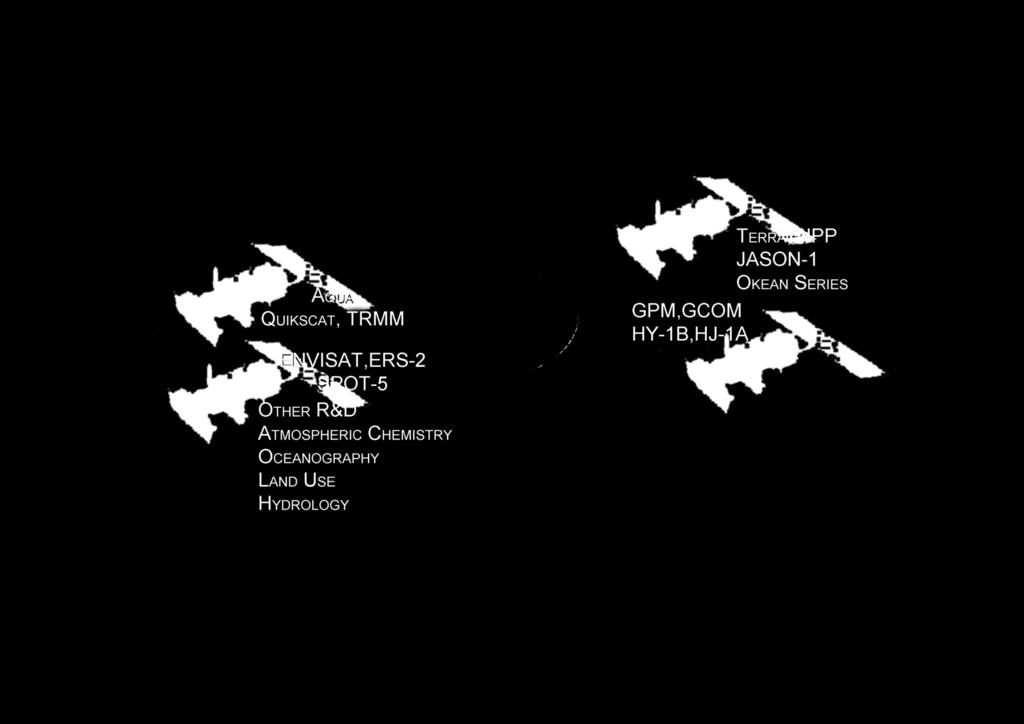
22 M E T E O R 3 M ( R u s sia n F e d e r a t io n ) F Y - 1 ( C h in a ) Oc e a n o g ra p h ic Missio n s A T G O E S -E (U S A ) 7 5 W I ON A R Y OR B I T K M G O E S - W ( U S A ) 135W Hig h -re so lu tio n La n d u se Missio n s S U B S A T E L L I T E P O IN T GE OS T R & D o rb it Po la Km M T S A T ( J a p a n ) E Atm o sp h e ric C h e m istry Missio n s M S G ( E U M E T S A T ) 0 L o n g it u d e M E T E O S A T ( E U M E T S A T ) 6 3 E r o rb it G O M S ( R u ssia n F e d e r a tio n ) 76E F Y -2 ( C h in a ) E Hyd ro lo g ic a l Missio n s N P O E S S ( U S A ) M e to p ( E U M E T S A T ) 22

23 23

24 24

25 25
26 Leo coverage of poles every 100 minutes 26

27 Tracking Polar Atmospheric Motion from Leo Obs 27

28 Getting to Geostationary Orbit 28

29 Observations from geostationary orbit the weather moves - not the satellite Verner Suomi 29

30 30

31 One minute imaging over Florida 31

32 32

33 SEVIRI sees dust storm over Africa 33

34 Five geos are providing global coverage for winds in tropics and mid-lats 34
35 Comparison of geostationary (geo) and low earth orbiting (leo) satellite capabilities Geo Leo observes process itself (motion and targets of opportunity) repeat coverage in minutes ( t 30 minutes) full earth disk only best viewing of tropics same viewing angle differing solar illumination observes effects of process repeat coverage twice daily ( t = 12 hours) global coverage best viewing of poles varying viewing angle same solar illumination visible, IR imager visible, IR imager (1, 4 km resolution) (1, 1 km resolution) one visible band multispectral in visible (veggie index) IR only sounder IR and microwave sounder (8 km resolution) (1, 17, 50 km resolution) filter radiometer diffraction more than leo filter radiometer, interferometer, and grating spectrometer diffraction less than geo 35


36 Space-Based component of the Global Observing System (GOS) 36

37 Leo Observations Terra was launched in 1999 and the EOS Era began MODIS, CERES, MOPITT, ASTER, and MISR reach polar orbit Aqua and ENVISAT followed in 2002 MODIS and MERIS to be followed by VIIRS AIRS and IASI to be followed by CrIS AMSU leading to ATMS 37


: 250 m Bands 3-7 (0.47, 0.")
: 500 m Launch date:")

38 Launch of EOS-Terra (EOS-AM) Satellite - A New Era Begins Others include: MISR MOPITT CERES ASTER MODIS 110 MODIS instrument Specifications: Bands 1-2 (0.66,0.86 mm): 250 m Bands 3-7 (0.47, 0.55, 1.24, 1.64, 2.13 mm): 500 m Launch date: December 18, 1999, 1:57 PT Earth viewdoor open date: February 24, 2001 Bands 8-36: 1 km Allen Chu/NASA GSFC 38


39 Followed by the launch of EOS-Aqua (EOS-PM) Satellite Thermometer in the Sky AMSR-E AMSU HSB Launch date: May 4, 2002, 2:55 PDT Earth view door open date: June 25, 2002 MODIS AIRS CERES 39


40 Joint Polar System Welcome METOP Congratulations ESA / EUMETSAT IASI 40


41 Atmospheric Products: Examples Winds Total Water Vapor Temperature 500 mb Rain Rate Ozone Aerosol Optical Thickness 41


42 Land Surface Products: Examples Vegetation Health Quebec Fires/Smoke Snow Solar Radiation Global Lights/Fires 42


43 Ocean Products: Examples SST Anomalies Hot Spots: Potential Coral Bleaching TOPEX Sea Level QuikSCAT Winds Sea WIFS Ocean Color 43
44 * provides a regional view Remote Sensing Advantages * enables one to observe & measure the causes & effects of climate & environmental changes (both natural & human-induced) * provides repetitive geo-referenced looks at the same area * covers a broader portion of the spectrum than the human eye * can focus in on a very specific bandwidth in an image * can also look at a number of bandwidths simultaneously * operates in all seasons, at night, and in bad weather 44
45 Welcome to a Short Course in Remote Sensing 45
46 Brienza Short Course in Remote Sensing Sep
Applications with the Newest Multi-spectral Environmental Satellites Lectures and Labs in Madison from 25 to 29 Mar 2013.
 Applications with the Newest Multi-spectral Environmental Satellites Lectures and Labs in Madison from 25 to 29 Mar 2013 Paul Menzel RS Bootcamp Agenda for 25 29 March 2013 in Room 1411 Monday 9 11 am
Summary Remote Sensing Seminar
 Summary Remote Sensing Seminar Lectures at CREST Paul Menzel NOAA/NESDIS/ORA March 2006 Satellite remote sensing of the Earth-atmosphere Observations depend on telescope characteristics (resolving power,
Radiative Transfer in the Atmosphere
 Radiative Transfer in the Atmosphere Lectures in Brienza 19 Sep 2011 Paul Menzel UW/CIMSS/AOS Outline Radiation Definitions Planck Function Emission, Absorption, Scattering Radiative Transfer Equation
Topics: Visible & Infrared Measurement Principal Radiation and the Planck Function Infrared Radiative Transfer Equation
 Review of Remote Sensing Fundamentals Allen Huang Cooperative Institute for Meteorological Satellite Studies Space Science & Engineering Center University of Wisconsin-Madison, USA Topics: Visible & Infrared
APPLICATIONS WITH METEOROLOGICAL SATELLITES. W. Paul Menzel. Office of Research and Applications NOAA/NESDIS University of Wisconsin Madison, WI
 APPLICATIONS WITH METEOROLOGICAL SATELLITES by W. Paul Menzel Office of Research and Applications NOAA/NESDIS University of Wisconsin Madison, WI July 2004 Unpublished Work Copyright Pending TABLE OF CONTENTS
Interpretation of Polar-orbiting Satellite Observations. Atmospheric Instrumentation
 Interpretation of Polar-orbiting Satellite Observations Outline Polar-Orbiting Observations: Review of Polar-Orbiting Satellite Systems Overview of Currently Active Satellites / Sensors Overview of Sensor
Summary of Satellite Remote Sensing Concepts
 Summary of Satellite Remote Sensing Concepts Lectures in Brienza 24 Sep 2011 Paul Menzel UW/CIMSS/AOS 1 Brienza 2011 2 Brienza 2011 3 Satellite remote sensing of the Earth-atmosphere Observations depend
History of Aerosol Remote Sensing. Mark Smithgall Maria Zatko 597K Spring 2009
 History of Aerosol Remote Sensing Mark Smithgall Maria Zatko 597K Spring 2009 Aerosol Sources Anthropogenic Biological decomposition from fertilizer and sewage treatment (ex. ammonium) Combustion of fossil
Lecture 4: Radiation Transfer
 Lecture 4: Radiation Transfer Spectrum of radiation Stefan-Boltzmann law Selective absorption and emission Reflection and scattering Remote sensing Importance of Radiation Transfer Virtually all the exchange
REVISION OF THE STATEMENT OF GUIDANCE FOR GLOBAL NUMERICAL WEATHER PREDICTION. (Submitted by Dr. J. Eyre)
") WORLD METEOROLOGICAL ORGANIZATION Distr.: RESTRICTED CBS/OPAG-IOS (ODRRGOS-5)/Doc.5, Add.5 (11.VI.2002) COMMISSION FOR BASIC SYSTEMS OPEN PROGRAMME AREA GROUP ON INTEGRATED OBSERVING SYSTEMS ITEM: 4 EXPERT
WORLD METEOROLOGICAL ORGANIZATION Distr.: RESTRICTED CBS/OPAG-IOS (ODRRGOS-5)/Doc.5, Add.5 (11.VI.2002) COMMISSION FOR BASIC SYSTEMS OPEN PROGRAMME AREA GROUP ON INTEGRATED OBSERVING SYSTEMS ITEM: 4 EXPERT
Physical Basics of Remote-Sensing with Satellites
 - Physical Basics of Remote-Sensing with Satellites Dr. K. Dieter Klaes EUMETSAT Meteorological Division Am Kavalleriesand 31 D-64295 Darmstadt dieter.klaes@eumetsat.int Slide: 1 EUM/MET/VWG/09/0162 MET/DK
F O U N D A T I O N A L C O U R S E
 F O U N D A T I O N A L C O U R S E December 6, 2018 Satellite Foundational Course for JPSS (SatFC-J) F O U N D A T I O N A L C O U R S E Introduction to Microwave Remote Sensing (with a focus on passive
McIDAS support of Suomi-NPP /JPSS and GOES-R L2
 McIDAS support of Suomi-NPP /JPSS and GOES-R L2 William Straka III 1 Tommy Jasmin 1, Bob Carp 1 1 Cooperative Institute for Meteorological Satellite Studies, Space Science and Engineering Center, University
Instrumentation planned for MetOp-SG
 Instrumentation planned for MetOp-SG Bill Bell Satellite Radiance Assimilation Group Met Office Crown copyright Met Office Outline Background - the MetOp-SG programme The MetOp-SG instruments Summary Acknowledgements:
- satellite orbits. Further Reading: Chapter 04 of the text book. Outline. - satellite sensor measurements
 (1 of 12) Further Reading: Chapter 04 of the text book Outline - satellite orbits - satellite sensor measurements - remote sensing of land, atmosphere and oceans (2 of 12) Introduction Remote Sensing:
Joint Polar Satellite System. 3 rd Post-EPS User Consultation Workshop Mike Haas
 3 rd Post-EPS User Consultation Workshop Mike Haas Overview Introduction - Policy Drivers - Management System Description - Space Segment - Ground Segment Partnerships Status Benefits 2 Introduction (Policy
Meteorological Satellite Image Interpretations, Part III. Acknowledgement: Dr. S. Kidder at Colorado State Univ.
 Meteorological Satellite Image Interpretations, Part III Acknowledgement: Dr. S. Kidder at Colorado State Univ. Dates EAS417 Topics Jan 30 Introduction & Matlab tutorial Feb 1 Satellite orbits & navigation
NOAA Report. Hal Bloom Mitch Goldberg NOAA/NESDIS
 NOAA Report Hal Bloom Mitch Goldberg NOAA/NESDIS Summary of Major Events at NESDIS (of interest to ITSC) NOAA/NASA addressing NPOESS Climate Sensors Letter of agreement signed with JAXA on GCOM interagency
Monitoring Air Pollution from Space
 Monitoring Air Pollution from Space Media Regional Training Workshop 16 th Nov 20 th Nov 2015 Shreta Ghimire International Centre for Integrated Mountain Development Kathmandu, Nepal Why do we study air
Lectures 7 and 8: 14, 16 Oct Sea Surface Temperature
 Lectures 7 and 8: 14, 16 Oct 2008 Sea Surface Temperature References: Martin, S., 2004, An Introduction to Ocean Remote Sensing, Cambridge University Press, 454 pp. Chapter 7. Robinson, I. S., 2004, Measuring
Remote Sensing I: Basics
 Remote Sensing I: Basics Kelly M. Brunt Earth System Science Interdisciplinary Center, University of Maryland Cryospheric Science Laboratory, Goddard Space Flight Center kelly.m.brunt@nasa.gov (Based on
Principles of Radiative Transfer Principles of Remote Sensing. Marianne König EUMETSAT
 - Principles of Radiative Transfer Principles of Remote Sensing Marianne König EUMETSAT marianne.koenig@eumetsat.int Remote Sensing All measurement processes which perform observations/measurements of
Comparison of NASA AIRS and MODIS Land Surface Temperature and Infrared Emissivity Measurements from the EOS AQUA platform
 Comparison of NASA AIRS and MODIS Land Surface Temperature and Infrared Emissivity Measurements from the EOS AQUA platform Robert Knuteson, Steve Ackerman, Hank Revercomb, Dave Tobin University of Wisconsin-Madison
Lecture 19: Operational Remote Sensing in Visible, IR, and Microwave Channels
 MET 4994 Remote Sensing: Radar and Satellite Meteorology MET 5994 Remote Sensing in Meteorology Lecture 19: Operational Remote Sensing in Visible, IR, and Microwave Channels Before you use data from any
Remote Sensing in Meteorology: Satellites and Radar. AT 351 Lab 10 April 2, Remote Sensing
 Remote Sensing in Meteorology: Satellites and Radar AT 351 Lab 10 April 2, 2008 Remote Sensing Remote sensing is gathering information about something without being in physical contact with it typically
Satellite observation of atmospheric dust
 Satellite observation of atmospheric dust Taichu Y. Tanaka Meteorological Research Institute, Japan Meteorological Agency 11 April 2017, SDS WAS: Dust observation and modeling @WMO, Geneva Dust observations
RTTOV 10 Theory & Exercise
 RTTOV 10 Theory & Exercise Ø Overview of RTTOVS Radiative Transfer Model q Gases Absorption (water Vapor & other trace gases) q Aerosol/Clouds Scattering and Absorption q Surface Emissivity/Reflectivity
Remote Sensing: Introduction
 Curso Intensivo sobre Asimilación de Datos 27 de Octubre - 7 de Noviembre de 2008 Aula Magna, Pabellon I, Ciudad Universitaria Buenos Aires, Argentina Remote Sensing: Introduction Inés Velasco Departamento
ESM 186 Environmental Remote Sensing and ESM 186 Lab Syllabus Winter 2012
 ESM 186 Environmental Remote Sensing and ESM 186 Lab Syllabus Winter 2012 Instructor: Susan Ustin (slustin@ucdavis.edu) Phone: 752-0621 Office: 233 Veihmeyer Hall and 115A, the Barn Office Hours: Tuesday
PRINCIPLES OF REMOTE SENSING. Electromagnetic Energy and Spectral Signatures
 PRINCIPLES OF REMOTE SENSING Electromagnetic Energy and Spectral Signatures Remote sensing is the science and art of acquiring and analyzing information about objects or phenomena from a distance. As humans,
Summary of Satellite Remote Sensing Concepts
 Summary of Satellite Remote Sensing Concepts Madison 29 Mar 2013 Paul Menzel UW/CIMSS 1 Satellite remote sensing of the Earth-atmosphere Observations depend on telescope characteristics (resolving power,
GEOSC/METEO 597K Kevin Bowley Kaitlin Walsh
 GEOSC/METEO 597K Kevin Bowley Kaitlin Walsh Timeline of Satellites ERS-1 (1991-2000) NSCAT (1996) Envisat (2002) RADARSAT (2007) Seasat (1978) TOPEX/Poseidon (1992-2005) QuikSCAT (1999) Jason-2 (2008)
Introduction of the Hyperspectral Environmental Suite (HES) on GOES-R and beyond
 on GOES-R and beyond") Introduction of the Hyperspectral Environmental Suite (HES) on GOES-R and beyond Timothy J. Schmit SaTellite Applications and Research (STAR) Advanced Satellite Products Team (ASPT) Presented by Jun Li
Introduction of the Hyperspectral Environmental Suite (HES) on GOES-R and beyond Timothy J. Schmit SaTellite Applications and Research (STAR) Advanced Satellite Products Team (ASPT) Presented by Jun Li
Lecture 4b: Meteorological Satellites and Instruments. Acknowledgement: Dr. S. Kidder at Colorado State Univ.
 Lecture 4b: Meteorological Satellites and Instruments Acknowledgement: Dr. S. Kidder at Colorado State Univ. US Geostationary satellites - GOES (Geostationary Operational Environmental Satellites) US
Chapter 4 Nadir looking UV measurement. Part-I: Theory and algorithm
 Chapter 4 Nadir looking UV measurement. Part-I: Theory and algorithm -Aerosol and tropospheric ozone retrieval method using continuous UV spectra- Atmospheric composition measurements from satellites are
Back to basics: From Sputnik to Envisat, and beyond: The use of satellite measurements in weather forecasting and research: Part 1 A history
 Back to basics: From Sputnik to Envisat, and beyond: The use of satellite measurements in weather forecasting and research: Part 1 A history Roger Brugge 1 and Matthew Stuttard 2 1 NERC Data Assimilation
Lectures 7 and 8: 13, 18 Feb Sea Surface Temperature
 Lectures 7 and 8: 13, 18 Feb 2008 Sea Surface Temperature References: Martin, S., 2004, An Introduction to Ocean Remote Sensing, Cambridge University Press, 454 pp. Chapter 7. Robinson, I. S., 2004, Measuring
Energy and the Earth AOSC 200 Tim Canty
 Energy and the Earth AOSC 200 Tim Canty Class Web Site: http://www.atmos.umd.edu/~tcanty/aosc200 Topics for today: Energy absorption Radiative Equilibirum Lecture 08 Feb 21 2019 1 Today s Weather Map http://www.wpc.ncep.noaa.gov/sfc/namussfcwbg.gif
Remote Sensing Seminar 8 June 2007 Benevento, Italy. Lab 5 SEVIRI and MODIS Clouds and Fires
 Remote Sensing Seminar 8 June 2007 Benevento, Italy Lab 5 SEVIRI and MODIS Clouds and Fires Table: SEVIRI Channel Number, Wavelength (µm), and Primary Application Reflective Bands 1,2 0.635, 0.81 land/cld
EUMETSAT STATUS AND PLANS
 1 EUM/TSS/VWG/15/826793 07/10/2015 EUMETSAT STATUS AND PLANS François Montagner, Marine Applications Manager, EUMETSAT WMO Polar Space Task Group 5 5-7 October 2015, DLR, Oberpfaffenhofen PSTG Strategic
REMOTE SENSING OF THE ATMOSPHERE AND OCEANS
 EAS 6145 SPRING 2007 REMOTE SENSING OF THE ATMOSPHERE AND OCEANS Instructor: Prof. Irina N. Sokolik office 2258, phone 404-894-6180 isokolik@eas.gatech.edu Meeting Time: Mondays: 3:05-4:25 PM Wednesdays:
A 2016 CEOS Chair Initiative. Non-meteorological Applications for Next Generation Geostationary Satellites
 A 2016 CEOS Chair Initiative Committee on Earth Observation Satellites Non-meteorological Applications for Next Generation Geostationary Satellites Co-chaired by EUMETSAT (Holmlund), CSIRO (Schroeder),
Appendix B. A proposition for updating the environmental standards using real Earth Albedo and Earth IR Flux for Spacecraft Thermal Analysis
 19 Appendix B A proposition for updating the environmental standards using real Earth Albedo and Earth IR Romain Peyrou-Lauga (ESA/ESTEC, The Netherlands) 31 st European Space Thermal Analysis Workshop
The Use of Hyperspectral Infrared Radiances In Numerical Weather Prediction
 The Use of Hyperspectral Infrared Radiances In Numerical Weather Prediction J. Le Marshall 1, J. Jung 1, J. Derber 1, T. Zapotocny 2, W. L. Smith 3, D. Zhou 4, R. Treadon 1, S. Lord 1, M. Goldberg 1 and
The Copernicus Sentinel-5 Mission: Daily Global Data for Air Quality, Climate and Stratospheric Ozone Applications
 SENTINEL-5 The Copernicus Sentinel-5 Mission: Daily Global Data for Air Quality, Climate and Stratospheric Ozone Applications Yasjka Meijer RHEA for ESA, Noordwijk, NL 15/04/2016 Co-Authors: Jörg Langen,
Feature-tracked 3D Winds from Satellite Sounders: Derivation and Impact in Global Models
 Feature-tracked 3D Winds from Satellite Sounders: Derivation and Impact in Global Models David Santek 1, A.-S. Daloz 1, S. Tushaus 1, M. Rogal 1, W. McCarty 2 1 Space Science and Engineering Center/University
Climate & Earth System Science. Introduction to Meteorology & Climate. Chapter 05 SOME OBSERVING INSTRUMENTS. Instrument Enclosure.
 Climate & Earth System Science Introduction to Meteorology & Climate MAPH 10050 Peter Lynch Peter Lynch Meteorology & Climate Centre School of Mathematical Sciences University College Dublin Meteorology
VALIDATION OF INSAT-3D DERIVED RAINFALL. (Submitted by Suman Goyal, IMD) Summary and Purpose of Document
 Summary and Purpose of Document") WORLD METEOROLOGICAL ORGANIZATION COMMISSION FOR BASIC SYSTEMS OPEN PROGRAMME AREA GROUP ON INTEGRATED OBSERVING SYSTEMS INTER-PROGRAMME EXPERT TEAM ON SATELLITE UTILIZATION AND PRODUCTS SECOND SESSION
WORLD METEOROLOGICAL ORGANIZATION COMMISSION FOR BASIC SYSTEMS OPEN PROGRAMME AREA GROUP ON INTEGRATED OBSERVING SYSTEMS INTER-PROGRAMME EXPERT TEAM ON SATELLITE UTILIZATION AND PRODUCTS SECOND SESSION
REMOTE SENSING KEY!!
 REMOTE SENSING KEY!! This is a really ugly cover page I m sorry. Name Key. Score / 100 Directions: You have 50 minutes to take this test. You may use a cheatsheet (2 pages), a non-graphing calculator,
Atmospheric Measurements from Space
 Atmospheric Measurements from Space MPI Mainz Germany Thomas Wagner Satellite Group MPI Mainz Part 1: Basics Break Part 2: Applications Part 1: Basics of satellite remote sensing Why atmospheric satellite
CIMSS Hyperspectral IR Sounding Retrieval (CHISR) Processing & Applications
 Processing & Applications") CIMSS Hyperspectral IR Sounding Retrieval (CHISR) Processing & Applications Jun Li @, Elisabeth Weisz @, Jinlong Li @, Hui Liu #, Timothy J. Schmit &, Jason Otkin @ and many other CIMSS collaborators @Cooperative
CIMSS Hyperspectral IR Sounding Retrieval (CHISR) Processing & Applications Jun Li @, Elisabeth Weisz @, Jinlong Li @, Hui Liu #, Timothy J. Schmit &, Jason Otkin @ and many other CIMSS collaborators @Cooperative
Hand in Question sheets with answer booklets Calculators allowed Mobile telephones or other devices not allowed
 York University Department of Earth and Space Science and Engineering ESSE 3030 Department of Physics and Astronomy PHYS 3080 Atmospheric Radiation and Thermodynamics Final Examination 2:00 PM 11 December
Blackbody radiation. Main Laws. Brightness temperature. 1. Concepts of a blackbody and thermodynamical equilibrium.
 Lecture 4 lackbody radiation. Main Laws. rightness temperature. Objectives: 1. Concepts of a blackbody, thermodynamical equilibrium, and local thermodynamical equilibrium.. Main laws: lackbody emission:
GEOG Lecture 8. Orbits, scale and trade-offs
 Environmental Remote Sensing GEOG 2021 Lecture 8 Orbits, scale and trade-offs Orbits revisit Orbits geostationary (36 000 km altitude) polar orbiting (200-1000 km altitude) Orbits revisit Orbits geostationary
1. The frequency of an electromagnetic wave is proportional to its wavelength. a. directly *b. inversely
 CHAPTER 3 SOLAR AND TERRESTRIAL RADIATION MULTIPLE CHOICE QUESTIONS 1. The frequency of an electromagnetic wave is proportional to its wavelength. a. directly *b. inversely 2. is the distance between successive
Earth: the Goldilocks Planet
 Earth: the Goldilocks Planet Not too hot (460 C) Fig. 3-1 Not too cold (-55 C) Wave properties: Wavelength, velocity, and? Fig. 3-2 Reviewing units: Wavelength = distance (meters or nanometers, etc.) Velocity
EUMETSAT NEWS. Marianne König.
 EUMETSAT NEWS Marianne König marianne.koenig@eumetsat.int www.eumetsat.int MUG 2010 26 Member States & 5 Cooperating States * Member States AUSTRIA BELGIUM CROATIA CZECH REPUBLIC DENMARK FINLAND FRANCE
Lecture 4: Meteorological Satellites and Instruments. Acknowledgement: Dr. S. Kidder at Colorado State Univ.
 Lecture 4: Meteorological Satellites and Instruments Acknowledgement: Dr. S. Kidder at Colorado State Univ. Homework for the Spring Break: get some tangible, preliminary results for your final project.
Remote Sensing How we know what we know A Brief Tour
 Remote Sensing How we know what we know A Brief Tour Dr. Erik Richard Dr. Jerald Harder LASP Richard 1 Remote Sensing The measurement of physical variables (usually light or sound) from outside of a medium
Outline of 4 Lectures
 Outline of 4 Lectures 1. Sept. 17, 2008: TC best track definition and datasets, global distribution of TCs; Review of history of meteorological satellites, introducing different orbits, scanning patterns,
Preface to the Second Edition. Preface to the First Edition
 Contents Preface to the Second Edition Preface to the First Edition iii v 1 Introduction 1 1.1 Relevance for Climate and Weather........... 1 1.1.1 Solar Radiation.................. 2 1.1.2 Thermal Infrared
OSSE to infer the impact of Arctic AMVs extracted from highly elliptical orbit imagery
 OSSE to infer the impact of Arctic AMVs extracted from highly elliptical orbit imagery L. Garand 1 Y. Rochon 1, S. Heilliette 1, J. Feng 1, A.P. Trishchenko 2 1 Environment Canada, 2 Canada Center for
Hyperspectral Atmospheric Correction
 Hyperspectral Atmospheric Correction Bo-Cai Gao June 2015 Remote Sensing Division Naval Research Laboratory, Washington, DC USA BACKGROUND The concept of imaging spectroscopy, or hyperspectral imaging,
Single footprint sounding, surface emissivity and cloud property retrievals from hyperspectral infrared radiances under all sky conditions
 Single footprint sounding, surface emissivity and cloud property retrievals from hyperspectral infrared radiances under all sky conditions Jun Li @, Elisabeth Weisz @, Jinlong Li @, Allen Huang @, Chian-Yi
Atmospheric Soundings of Temperature, Moisture and Ozone from AIRS
 Atmospheric Soundings of Temperature, Moisture and Ozone from AIRS M.D. Goldberg, W. Wolf, L. Zhou, M. Divakarla,, C.D. Barnet, L. McMillin, NOAA/NESDIS/ORA Oct 31, 2003 Presented at ITSC-13 Risk Reduction
History of Earth Radiation Budget Measurements With results from a recent assessment
 History of Earth Radiation Budget Measurements With results from a recent assessment Ehrhard Raschke and Stefan Kinne Institute of Meteorology, University Hamburg MPI Meteorology, Hamburg, Germany Centenary
Non-meteorological Applications for Next Generation Geostationary Meteorological Satellites
 Non-meteorological Applications for Next Generation Geostationary Meteorological Satellites Toshiyuki KURINO Satellite Program Division Japan Meteorological Agency Topics Advanced GEO for Earth Observation
GRACE Cloudsat CALIPSO Aqua. Metop TRMM TOPEX. Meteor/ SAGE GIFTS NOAA/ POES. Landsat GOES MTSAT. SeaWiFS. Aura. Terra MSG. Jason ICESat SORCE
 TRMM Metop GRACE Cloudsat CALIPSO Aqua TOPEX Meteor/ SAGE GIFTS NOAA/ POES Landsat GOES SeaWiFS MTSAT Terra Aura Jason ICESat SORCE MSG THE EARTH SYSTEM SCIENCE It is the science that studies the whole
A new perspective on aerosol direct radiative effects in South Atlantic and Southern Africa
 A new perspective on aerosol direct radiative effects in South Atlantic and Southern Africa Ian Chang and Sundar A. Christopher Department of Atmospheric Science University of Alabama in Huntsville, U.S.A.
Analyzing and Visualizing Precipitation and Soil Moisture in ArcGIS
 Analyzing and Visualizing Precipitation and Soil Moisture in ArcGIS Wenli Yang, Pham Long, Peisheng Zhao, Steve Kempler, and Jennifer Wei * NASA Goddard Earth Science Data and Information Services Center
Update on GEO Hyperspectral Sounders: GIFTS and GeoMetWatch Storm
 14 September 2010 Update on GEO Hyperspectral Sounders: GIFTS and GeoMetWatch Storm Hank Revercomb University of Wisconsin - Madison Space Science and Engineering Center (SSEC) WMO Commission for Atmospheric
Preparation for FY-4A. (Submitted by Xiang Fang, CMA)
") WORLD METEOROLOGICAL ORGANIZATION COMMISSION FOR BASIC SYSTEMS OPEN PROGRAMME AREA GROUP ON INTEGRATED OBSERVING SYSTEMS EXPERT TEAM ON SATELLITE UTILIZATION AND PRODUCTS ET-SUP-8/Doc. 10.3 (2.IV.2014)
WORLD METEOROLOGICAL ORGANIZATION COMMISSION FOR BASIC SYSTEMS OPEN PROGRAMME AREA GROUP ON INTEGRATED OBSERVING SYSTEMS EXPERT TEAM ON SATELLITE UTILIZATION AND PRODUCTS ET-SUP-8/Doc. 10.3 (2.IV.2014)
Feature-tracked 3D Winds from Satellite Sounders: Derivation and Impact in Global Models
 Feature-tracked 3D Winds from Satellite Sounders: Derivation and Impact in Global Models David Santek, Anne-Sophie Daloz 1, Samantha Tushaus 1, Marek Rogal 1, Will McCarty 2 1 Space Science and Engineering
Inaugural University of Michigan Science Olympiad Tournament
 Inaugural University of Michigan Science Olympiad Tournament The test may be taken apart. Ties will be broken based on predetermined questions and quality of response. Remote Sensing Test length: 50 Minutes
The MODIS Cloud Data Record
 The MODIS Cloud Data Record Brent C. Maddux 1,2 Steve Platnick 3, Steven A. Ackerman 1 Paul Menzel 1, Kathy Strabala 1, Richard Frey 1, 1 Cooperative Institute for Meteorological Satellite Studies, 2 Department
EUMETSAT PLANS. K. Dieter Klaes EUMETSAT Darmstadt, Germany
 EUMETSAT PLANS K. Dieter Klaes EUMETSAT Darmstadt, Germany 1. INTRODUCTION The European Organisation for the Exploitation of Meteorological Satellites (EUMETSAT), contributes to the World Weather Watch
Study of the Influence of Thin Cirrus Clouds on Satellite Radiances Using Raman Lidar and GOES Data
 Study of the Influence of Thin Cirrus Clouds on Satellite Radiances Using Raman Lidar and GOES Data D. N. Whiteman, D. O C. Starr, and G. Schwemmer National Aeronautics and Space Administration Goddard
CLOUD CLASSIFICATION AND CLOUD PROPERTY RETRIEVAL FROM MODIS AND AIRS
 6.4 CLOUD CLASSIFICATION AND CLOUD PROPERTY RETRIEVAL FROM MODIS AND AIRS Jun Li *, W. Paul Menzel @, Timothy, J. Schmit @, Zhenglong Li *, and James Gurka # *Cooperative Institute for Meteorological Satellite
Changes in Earth s Albedo Measured by satellite
 Changes in Earth s Albedo Measured by satellite Bruce A. Wielicki, Takmeng Wong, Norman Loeb, Patrick Minnis, Kory Priestley, Robert Kandel Presented by Yunsoo Choi Earth s albedo Earth s albedo The climate
CGMS Baseline. Sustained contributions to the Global Observing System. Endorsed by CGMS-46 in Bengaluru, June 2018
 CGMS Baseline Sustained contributions to the Global Observing System Best Practices for Achieving User Readiness for New Meteorological Satellites Endorsed by CGMS-46 in Bengaluru, June 2018 CGMS/DOC/18/1028862,
ESA Cloud-CCI Phase 1 Results Climate Research Perspective
 ESA Cloud-CCI Phase 1 Results Climate Research Perspective Claudia Stubenrauch Laboratoire de Météorologie Dynamique, France and Cloud-CCI Team Outline Ø Challenges to retrieve cloud properties Ø What
SAN FRANCISCO STATE UNIVERSITY NAME DEPARTMENT OF GEOSCIENCES Spring 2013
 SAN FRANCISCO STATE UNIVERSITY NAME DEPARTMENT OF GEOSCIENCES Spring 2013 METR 415/715: MONTEVERDI QUIZ 1 Open Book and Open Notes 200 points, 45 minutes 1. Compute the altitude of a geostationary orbit
IDEA. from research to routine
 IDEA. from research to routine A collaboration between NASA, EPA, NOAA and CIMSS Cooperative Institute for Meteorological Satellite Studies Infusing satellite Data in Environmental Applications (IDEA)
Introduction of the Hyperspectral Environmental Suite (HES) on GOES-R and beyond
 on GOES-R and beyond") Introduction of the Hyperspectral Environmental Suite (HES) on GOES-R and beyond 1 Timothy J. Schmit, 2 Jun Li, 3 James Gurka 1 NOAA/NESDIS, Office of Research and Applications, Advanced Satellite Products
Introduction of the Hyperspectral Environmental Suite (HES) on GOES-R and beyond 1 Timothy J. Schmit, 2 Jun Li, 3 James Gurka 1 NOAA/NESDIS, Office of Research and Applications, Advanced Satellite Products
A New Microwave Snow Emissivity Model
 A New Microwave Snow Emissivity Model Fuzhong Weng 1,2 1. Joint Center for Satellite Data Assimilation 2. NOAA/NESDIS/Office of Research and Applications Banghua Yan DSTI. Inc The 13 th International TOVS
Update on SCOPE-Nowcasting Pilot Project Real Time Ocean Products Suman Goyal Scientist-E
 Update on SCOPE-Nowcasting Pilot Project Real Time Ocean Products Suman Goyal Scientist-E 19-22 Nov 2013 SCOPE-Nowcasting-1 Agenda Item 5 Pilot Projects Overview Users /Clients User requirements Product
Infrared continental surface emissivity spectra and skin temperature retrieved from IASI observation
 Infrared continental surface emissivity spectra and skin temperature retrieved from IASI observation Capelle V., Chédin A., Péquignot E., N. A Scott Schlüssel P., Newman S. IASI Conference 2013 Introduction
Lecture 2-07: The greenhouse, global heat engine.
 Lecture 2-07: The greenhouse, global heat engine http://en.wikipedia.org/ the sun s ultraviolet (left) and infrared radiation imagers.gsfc.nasa.gov/ems/uv.html www.odysseymagazine.com/images SOLAR FLARES
Introduction to Climate ~ Part I ~
 2015/11/16 TCC Seminar JMA Introduction to Climate ~ Part I ~ Shuhei MAEDA (MRI/JMA) Climate Research Department Meteorological Research Institute (MRI/JMA) 1 Outline of the lecture 1. Climate System (
NESDIS Polar (Region) Products and Plans. Jeff Key NOAA/NESDIS Madison, Wisconsin USA
 Products and Plans. Jeff Key NOAA/NESDIS Madison, Wisconsin USA") NESDIS Polar (Region) Products and Plans Jeff Key NOAA/NESDIS Madison, Wisconsin USA WMO Polar Space Task Group, 2 nd meeting, Geneva, 12 14 June 2012 Relevant Missions and Products GOES R ABI Fractional
NESDIS Polar (Region) Products and Plans Jeff Key NOAA/NESDIS Madison, Wisconsin USA WMO Polar Space Task Group, 2 nd meeting, Geneva, 12 14 June 2012 Relevant Missions and Products GOES R ABI Fractional
Sensitivity Study of the MODIS Cloud Top Property
 Sensitivity Study of the MODIS Cloud Top Property Algorithm to CO 2 Spectral Response Functions Hong Zhang a*, Richard Frey a and Paul Menzel b a Cooperative Institute for Meteorological Satellite Studies,
MASSACHUSETTS INSTITUTE OF TECHNOLOGY Department of Physics Problem Solving 10: The Greenhouse Effect. Section Table and Group
 MASSACHUSETTS INSTITUTE OF TECHNOLOGY Department of Physics 8.02 Problem Solving 10: The Greenhouse Effect Section Table and Group Names Hand in one copy per group at the end of the Friday Problem Solving
Hyperspectral Microwave Atmospheric Sounding
 Hyperspectral Microwave Atmospheric Sounding W. J. Blackwell, L. J. Bickmeier, R. V. Leslie, M. L. Pieper, J. E. Samra, and C. Surussavadee 1 April 14, 2010 ITSC-17 This work is sponsored by the Department
Menzel/Matarrese/Puca/Cimini/De Pasquale/Antonelli Lab 2 Ocean Properties inferred from MODIS data June 2006
 Menzel/Matarrese/Puca/Cimini/De Pasquale/Antonelli Lab 2 Ocean Properties inferred from MODIS data June 2006 Table: MODIS Channel Number, Wavelength (µm), and Primary Application Reflective Bands Emissive
Lecture 5: Greenhouse Effect
 Lecture 5: Greenhouse Effect S/4 * (1-A) T A 4 T S 4 T A 4 Wien s Law Shortwave and Longwave Radiation Selected Absorption Greenhouse Effect Global Energy Balance terrestrial radiation cooling Solar radiation
CORRELATION BETWEEN ATMOSPHERIC COMPOSITION AND VERTICAL STRUCTURE AS MEASURED BY THREE GENERATIONS OF HYPERSPECTRAL SOUNDERS IN SPACE
 CORRELATION BETWEEN ATMOSPHERIC COMPOSITION AND VERTICAL STRUCTURE AS MEASURED BY THREE GENERATIONS OF HYPERSPECTRAL SOUNDERS IN SPACE Nadia Smith 1, Elisabeth Weisz 1, and Allen Huang 1 1 Space Science
Improving Tropical Cyclone Forecasts by Assimilating Microwave Sounder Cloud-Screened Radiances and GPM precipitation measurements
 Improving Tropical Cyclone Forecasts by Assimilating Microwave Sounder Cloud-Screened Radiances and GPM precipitation measurements Hyojin Han a, Jun Li a, Mitch Goldberg b, Pei Wang a,c, Jinlong Li a,
Radiative Transfer Model based Bias Correction in INSAT-3D/3DR Thermal Observations to Improve Sea Surface Temperature Retrieval
 Radiative Transfer Model based Bias Correction in INSAT-3D/3DR Thermal Observations to Improve Sea Surface Temperature Retrieval Rishi K Gangwar, Buddhi P Jangid, and Pradeep K Thapliyal Space Applications
The use of Direct Broadcast Processing System in Poland
 The use of Direct Broadcast Processing System in Poland B.Łapeta, P.Struzik Satellite Remote Sensing Department, Institute of Meteortology and Water Management National Reasearch Institute About IMWM-NRI
Jun Park National Meteorological Satellite Center Korea Meteorological Administration
 KMA Implementation Plan for Satellite Climate products Jun Park National Meteorological Satellite Center Korea Meteorological Administration jun.park@kma.go.kr Outline 1. Introduction : Current & Future