R I O R E I M A G I N E D The Rio Salado Project
|
|
|
- Dana Patterson
- 5 years ago
- Views:
Transcription

1 Cheryl Lombard, President + CEO Valley Partnership The Rio Salado Project


2 21 R I O S A L A D O P R O J E C T 2

3 4 5 + m i. r e v i t a l i z a t i o n The Rio Salado project has the potential to transform the Salt River bottom and realize an untapped Valley treasure. - U.S. Senator John McCain P R O J E C T A R E A 3
4 p r o j e c t l e n g t h i n m i l e s P R E C E D E N T S C A L E Rio Salado Project San Antonio River Improvements Trinity River Vision, Ft. Worth Trinity River Corridor, Dallas Buffalo Bayou, Houston Chicago River Corridor Plan, Chicago The BeltLine, Atlanta Highline, NY Three Rivers Park, Pittsburgh Los Angeles River, Los Angeles 5
5 Valley POPULATION: 665,000 Valley POPULATION: 1,500,000 Valley POPULATION: 2,200,000 Valley POPULATION: 3,800,000 concept strategy referendum implementation rio reimagined ERA 1 ERA 2 ERA 3 ERA 4 ERA 5 Rio Salado Development District Established Tempe Town Lake Conceptual Development Plan Tempe Town Lake Construction Begins US Senator John McCain renews the vision for the Rio Salado Project with ASU Scottsdale Conference Rio Salado III Report Arizona Republic Editorial on Conference Tempe ASU Demonstration Project on Recreation Development Phoenix Magazine features Rio Salado Project Update Valley Forward Funds Rio Salado Feasibility Study through MAG Phoenix Magazine features Rio Salado Story to prepare for a County ballot Rio Salado Symposium Project Retrospective Public Referendum to fund a County wide Rio Salado Project fails Tempe Adopts Rio Salado Masterplan for Tempe Town Lake Office of US Senator McCain meets with Valley Leaders Valley Leaders event to collectively garner commitment Rio Salado Project Working Group established Initial student presentation of the Rio Salado Project Concept Initial news article In the Arizona Republic ASU College of Architecture Dean James Elmore led academic pursuits for a Rio Salado Vision R I O S A L A D O T I M E L I N E 6


6 WATER FUNDING ECON DEV COMMUNITY M A J O R T O P I C S 7


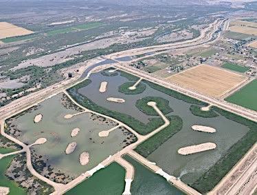
7 WATER P R O J E C T M U S T B E W A T E R P O S I T I V E A L AB O R A T O R Y F O R I N N O V A T I O N T I G H T L Y C A L I B R A T E D U S E S & I M P A C T M A J O R T O P I C S Tres Rios Wetlands 8

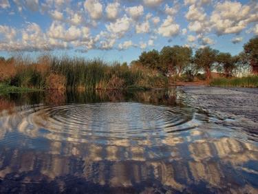
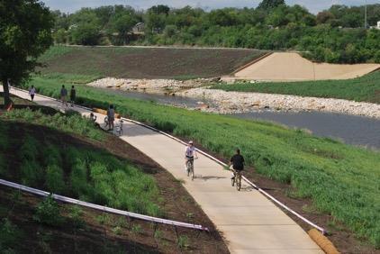
8 FUNDING R E S O U R C E S W I L L F OL L O W I D E A S D E E P A N A L Y S I S OF A L L A P P L I C A B L E S O U R C E S F E D E R AL U R B A N W A T E R S P R O G R A M E X A M P L E M A J O R T O P I C S Tempe Town Lake 10

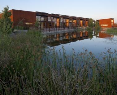
9 COMMUNITY F O C U S O N S O C I A L E Q U I T Y & I N T E G R A T I V E P L A N N I N G A C C E S S T O E D U C A T I O N, T R A I N I N G & E M P L O Y M E N T OF F E R C U L T U R AL L Y A W A R E P O I N T S OF E N G A G E M E N T M A J O R T O P I C S Rio Salado Audubon Center 12

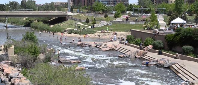
10 ECONOMY A C K N O W L D E G E L E G A C Y OF R I V E R I N D U S T R Y B R O W N F I E L D R E D E V E L O P M E N T O P P O R T U N I T I E S B E T H E C A P I T O L OF T H E S U S T A I N A B I L I T Y B U S I N E S S M A J O R T O P I C S Tempe Town Lake 14


11 San Antonio T X Houston T X Atlanta GA Fort Worth T X P R E C E D E N T A N A L Y S I S 16

12 M i l e R e v i t a l i z a t i o n Four Reaches Museum Reach 4 miles Downtown Reach 1.25 miles Eagleland 1 mile Mission Reach 8 miles Connects 2000 acres of public parkland Numerous historic sites and cultural assets 15 miles of continuous pedestrian paths River Walk Commercial District Water features Public art Flood management Ecosystem restoration and riparian woodlands Recreational improvements S A N A N T O N I O R I V E R San Antonio River Improvements Project 17

13 8 8 M i l e R e v i t a l i z a t i o n Trinity River, Tributaries + Greenbelts MARINE CRE E K 72 miles of trails 1000 acre park revitalization 800 acres of mixed use development with 12 miles of developable waterfront 33 acre lake Eight Segments Clear Fork North 5.5 miles Clear Fork South 5.5 miles Marine Creek 4 miles S ycamore Creek 8.5 miles West Fork East 12 miles West Fork West 9.5 miles Central City Uptown [Panther Is land] -10 miles WES T FORK - WES T CLEAR FORK CENT RAL CIT Y SYCAMORE CRE E K WES T FORK - EAS T 0 2 miles T R I N I T Y R I V E R F O R T W O R T H Fort Worth Parks Department 18

14 2 0 M i l e R e v i t a l i z a t i o n Multi-year Phased Master Plan Estimated at $1.7 Billion acres 7.2 mile 2000 acre Dallas Floodway protection 495 acres wetlands with 1 mile of nature boardwalks 205 acres of open water for wildlife habitat 2 lakes 150 acres for active and passive recreation 160 acres of playing fields 12 acre amphitheater 9 miles of recreation trails 3 miles of equestrian trails 9.1 mile T rinity River toll parkway to major arterials 7 total bridges incl. 1 signature bridge connecting to downtown 2500 acres of mixed use development T R I N I T Y R I V E R D A L L A S Trinity River Balanced Vision Plan 19

15 2 2 M i l e R e v i t a l i z a t i o n Historic Railroad Corridor 33 miles of multi-use trails 22 miles of light rail transit 1,300 acres of new greenspace 1,100 acres of remediated brownfields 5,600 units of affordable housing A T L A N T A B E L T L I N E M 20

16 2. 5 M i l e R e v i t a l i z a t i o n 163 Acres $53 Million S tabilized riverbank naturalized with woodland and prairie plants Large grass gathering areas Hike-and-bike trails S kate park Dog park Four formal gardens Performance pavilions Boat launch Public art B U F F A L O B A Y O U P A R K 21

17 5 1 M i l e To t a l R e v i t a l i z a t i o n UPPE R LA RIVE R 870 square miles of watershed Upper LA River is 21 miles City of Los Angeles is 11 miles Lower LA River from the City of Vernon to the LA River outlet in the City of Long Beach is 19 miles Restore ecosystem functions Balance revitalization with flood avoidance to ensure public safety Reduce reliance on imported water supply Foster sustainable stewardship CIT Y OF LOS ANGELE S LOWER LA RIVE R L O S A N G E L E S R I V E R 22

18 5 1 M i l e To t a l R e v i t a l i z a t i o n 11 Miles Los Angeles Current Project Area 8 Reaches 8 Phases L O S A N G E L E S R I V E R 18


19 21 P R E C E D E N T S T R U C T U R E 24
20 R i ver A U T H O R I T Y R evitali zation C O R P O R A T I O N P roject F O U N D A T I O N A cooperative agreement Via MOU between public entities for the river right-of-way with Army Corps and others A non-governmental organization tasked with implementing the plan through land development and project management A non-profit organization tasked with maintaining the vision, providing leadership and raising funds to support, execute, operate and maintain the project P R E C E D E N T S O R G S T R U C T U R E 26
21 21 P R E C E D E N T F U N D I N G 28
22 3% 16% 35% 28% 32% 21% 63% 58% San Antonio River 7% Trinity River Ft. Worth 37% Trinity River Dallas 11% 3% 7% 9% 3% 3% 27% 36% 43% 70% 88% Atlanta BeltLine Buffalo Bayou Los Angeles River FEDERAL P R E C E D E N T F U N D I N G S T ATE COUNTY CIT Y PRIVAT E 29 27
23 16 F E D E R A L R E S O U R C E S Tres Rios Wetlands 30 29


24 Rio Salado SR PMIC Riverview Mesa 16 LIBERT Y WILDLIFE NINA PULLIAM MASON RIO SALADO AUDUBON CENT E R Salt River Pima Maricopa Indian Community Avondale Phoenix T empe Mesa Buckeye Goodyear Gila River Indian Community Buckeye Central Arizona Conservation Alliance Mapping Portal - BETA EL RIO WATE RCOURS E MAST E R PLAN TRE S RIOS RIO SALADO OES T E RIO SALADO PHOENIX RIO SALADO TEMPE RIO SALADO MES A F E D E R A L R E S O U R C E S 31


25 Rio Salado SR PMIC Riverview Mesa 16 URBAN WAT E RS FEDERAL PART NERS HIP US Army Corps of Engineers F E D E R A L R E S O U R C E S 32

26 S T A K E H O L D E R F R A M E W O R K Rio Salado SRP-MIC Riverview Mesa 33

27 Advi s o r y Board Federal, State, County, T ribal and Local Elected Officials P roject Wor k i ng Group Professional Staff and Business Leadership Project Coordination Office of US Senator John McCain and ASU Technical Consultants as needed Federal Entities Economic Development Non-profit Orgs. Academia Utilities & S ervices Stakeholder Groups S T A K E H O L D E R F R A M E W O R K 34

28 C O M M E N T S + D I S C U S S I O N Tres Rios Wetlands 35

29 The Rio Salado project has the potential to transform the Salt River bottom and realize an untapped Valley treasure. - U.S. Senator John McCain T H A N K Y O U Tempe Town Lake 36
THE TRINITY RIVER VISION/ GATEWAY PARK / PANTHER ISLAND
 Quarterly Project Status Report May 2018 THE TRINITY RIVER VISION/ GATEWAY PARK / PANTHER ISLAND Flood Control Project Update Construction of North Main Street Bridge by TxDOT s bridge contractor, Texas
THE TRINITY RIVER VISION/ GATEWAY PARK / PANTHER ISLAND Flood Control Project Update
 Quarterly Project Status Report September 2018 THE TRINITY RIVER VISION/ GATEWAY PARK / PANTHER ISLAND Flood Control Project Update TxDot s contractor has nearly completed the superstructure false work
NEW WATERFRONT METROPARK. P u b l i c O p e n H o u s e, J u n e 2 1,
 NEW WATERFRONT METROPARK P u b l i c O p e n H o u s e, J u n e 2 1, 2 0 1 7 U N D E R S T A N D I N G YO U R P E R S P E C T I V E PUBLIC OPEN HOUSE Welcome/Introductions Project Presentation Project
GIS Data and Technology to Support Transportation & MPO Decision-Making & Planning. using an Eco-Logical* Approach within the Kansas City Region
 GIS Data and Technology to Support Transportation & MPO Decision-Making & Planning using an Eco-Logical* Approach within the Kansas City Region Authors (in alphabetical order): Tom Gerend, Tom Jacobs,
EVALUATION ACCORDING TO FEASIBILITY CRITERIA
 Chapter 8 EVALUATION ACCORDING TO FEASIBILITY CRITERIA If enacted, the National Heritage Partnerships Act will formalize the feasibility/suitability requirements of proposed National Heritage Areas. These
Proposed Scope of Work Village of Farmingdale Downtown Farmingdale BOA Step 2 BOA Nomination Study / Draft Generic Environmental Impact Statement
 Proposed Scope of Work Village of Farmingdale Downtown Farmingdale BOA Step 2 BOA Nomination Study / Draft Generic Environmental Impact Statement The scope of work that follows incorporates and covers
NCTCOG Regional GIS Meeting 6-Years and Going Strong. May 15, 2018 hosted by: Tarrant County
 NCTCOG Regional GIS Meeting 6-Years and Going Strong May 15, 2018 hosted by: Tarrant County Woolpert at a Glance 1911 Founded in Dayton, Ohio 25+ Offices across the nation 800+ Global employees 25+ OFFICES
New Partners for Smart Growth: Building Safe, Healthy, and Livable Communities Mayor Jay Williams, Youngstown OH
 New Partners for Smart Growth: Building Safe, Healthy, and Livable Communities Mayor Jay Williams, Youngstown OH The City of Youngstown Youngstown State University Urban Strategies Inc. Youngstown needed
Joint Planning Advisory Council July 19, 2011
 Joint Planning Advisory Council July 19, 2011 Global Cities Program Objectives Helping advance strategic thinking in a variety of critical areas. Facilitating informed decisionmaking on the part of public
East Bay BRT. Planning for Bus Rapid Transit
 East Bay BRT Planning for Bus Rapid Transit Regional Vision Draper Prison The Bottleneck is a State-Level issue, Salt Lake County 2050 Population: 1.5M Draper Prison hopefully with some State-Level funding!
King City URA 6D Concept Plan
 King City URA 6D Concept Plan King City s Evolution Among the fastest growing cities 2000 Census 1,949 2010 Census 3,111 60% increase 2016 Census estimate 3,817 23% increase Average annual rate 4.3% Surpassing
The CRP stresses a number of factors that point to both our changing demographics and our future opportunities with recommendations for:
 Plan Overview The CRP represents the first broad planning initiative covering Lake, Porter and LaPorte counties. Unlike previous plans released by NIRPC, which focused primarily on transportation, the
Earth Wind & Fire. Game Changing Restoration Options in the Texas Chenier Plain
 Earth Wind & Fire Game Changing Restoration Options in the Texas Chenier Plain EARTH: The Chenier Plain is a 5 million acre coastal region in Southwest Louisiana and Southeast Texas providing landscape
[Leveraging & Improving Neighborhood Connections] Area E Cedar Creek
![[Leveraging & Improving Neighborhood Connections] Area E Cedar Creek](/thumbs/86/93508963.jpg "[Leveraging & Improving Neighborhood Connections] Area E Cedar Creek") Community Charrette LINC Dallas [Leveraging & Improving Neighborhood Connections] Area E Cedar Creek 06.02.12 LINC Workshop Area E Area E has the unique distinction of at-grade frontage to the Trinity
Community Charrette LINC Dallas [Leveraging & Improving Neighborhood Connections] Area E Cedar Creek 06.02.12 LINC Workshop Area E Area E has the unique distinction of at-grade frontage to the Trinity
City of Pocatello. Comprehensive Plan Update
 City of Pocatello Comprehensive Plan 2015 Update Adopted March 5, 2015 Acknowledgements City of Pocatello Comprehensive Plan Update 2015 Mayor Brian Blad City Council Craig Cooper Steve Brown W. James
Locational business intelligence in the U.S. Forest Service: Geospatial Accomplishment Reporting ESRI USER CONFERENCE 2015 JULY 21, 2015
 Locational business intelligence in the U.S. Forest Service: Geospatial Accomplishment Reporting ESRI USER CONFERENCE 2015 JULY 21, 2015 Agenda Introduction to the US Forest Service Why geo-enable Performance
High Speed / Commuter Rail Suitability Analysis For Central And Southern Arizona
 High Speed / Commuter Rail Suitability Analysis For Central And Southern Arizona Item Type Reports (Electronic) Authors Deveney, Matthew R. Publisher The University of Arizona. Rights Copyright is held
CLAREMONT MASTER PLAN 2017: LAND USE COMMUNITY INPUT
 Planning and Development Department 14 North Street Claremont, New Hampshire 03743 Ph: (603) 542-7008 Fax: (603) 542-7033 Email: cityplanner@claremontnh.com www.claremontnh.com CLAREMONT MASTER PLAN 2017:
PROPOSED CONCEPT. Chapter 2
 Chapter 2 PROPOSED CONCEPT One of the most important tasks in building a National Heritage Area is conceptualizing it in sufficient detail. Questions that must be answered include: What are the underlying
The following maps must be provided as a part of the ADA. The appropriate scale for each map should be determined at the pre application conference.
 Main Street @ Coconut Creek DRI QUESTION 9 MAPS The following maps must be provided as a part of the ADA. The appropriate scale for each map should be determined at the pre application conference. Map
What s next for the Port Waterfront?
 What s next for the Port Waterfront? WATERFRONT LAND USE PLAN UPDATE The Port of San Francisco s Waterfront Land Use Plan ( Waterfront Plan ) guides land use and development on the Port s 7 1/2 mile public
Ecological Land Cover Classification For a Natural Resources Inventory in the Kansas City Region, USA
 Ecological Land Cover Classification For a Natural Resources Inventory in the Kansas City Region, USA by Applied Ecological Services, Inc. In cooperation with the Mid-America Regional Council 600 Broadway,
 Red River Flooding June 2015 Caddo and Bossier Parishes Presented by: Flood Technical Committee Where the Rain Falls Matters I-30 versus I-20 I-20 Backwater and Tributary Floods (Localized) 2016 Flood
TYPES OF GOVERNMENTS
 While the terms country, state, and nation are often used interchangeably, there is a difference. A State (note the capital "S") is a self-governing political entity. The term State can be used interchangeably
Austin. What is a Public Market? The original gathering place. Worldwide, ancient phenomenon. Ripe for a Public Market?
 Downtown Austin Alliance September 25, 2013 What is a Public Market? Austin Ripe for a Public Market? Have Public Goals Operate in Public Spaces Serve Locally Owned and Operated Businesses The original
MPOs SB 375 LAFCOs SCAG Practices/Experiences And Future Collaborations with LAFCOs
 Connecting LAFCOs and COGs for Mutual Benefits MPOs SB 375 LAFCOs SCAG Practices/Experiences And Future Collaborations with LAFCOs Frank Wen, Manager Research & Analysis Land Use & Environmental Planning
Planning for the Future of Humboldt Bay: Sea Level Rise, Sediment Management, Sand Spits and Salt Marshes. Joel Gerwein
 Planning for the Future of Humboldt Bay: Sea Level Rise, Sediment Management, Sand Spits and Salt Marshes Joel Gerwein Introduction to Humboldt Bay Setting Economy, community, and environment Sediment
Friends of Saguaro National Park. Strategic Plan
 Friends of Saguaro National Park Strategic Plan January, 2016 For the past 100 years, America s national park system has preserved and protected what Theodore Roosevelt described as the most glorious heritage
 BPC Policy No , IIM7fyilK Office of the District Clerk TRANSITION ZONE POLICY")
MONTHLY M&I DELIVERIES CALENDAR YEAR 2005 (By Classification) Table #1
 Table #1") MONTHLY M&I DELIVERIES Table #1 SUBCONTRACT Apache Junction WC 1 0 21 37 31 38 39 35 37 36 41 46 362 400 Arizona-American/PV 0 0 0 0 0 0 546 546 546 546 546 0 2,730 2,730 Arizona-American/WV 0 0 0 866
MONTHLY M&I DELIVERIES Table #1 SUBCONTRACT Apache Junction WC 1 0 21 37 31 38 39 35 37 36 41 46 362 400 Arizona-American/PV 0 0 0 0 0 0 546 546 546 546 546 0 2,730 2,730 Arizona-American/WV 0 0 0 866
THE PORTFIELDS INITIATIVE: REVITALIZING BROWNFIELDS IN PORT COMMUNITIES
 THE PORTFIELDS INITIATIVE: REVITALIZING BROWNFIELDS IN PORT COMMUNITIES Kenneth Walker, NOAA Office of Ocean and Coastal Resource Management Robert Neely, NOAA Office of Response and Restoration David
A Shift to the Sunbelt
 Adam Giladi 4/1/13 A Shift to the Sunbelt The changing global economy has lead to an increased interconnection between nations and the mass movement of individuals from one area to another. This movement
Kootenai River Habitat Restoration Program Update
 Kootenai River Habitat Restoration Program Update Kootenai Tribe of Idaho Kootenai Valley Resource Initiative November 19, 2012 Bonners Ferry, Idaho Changes to Kootenai Basin Beaver trapping Floodplain
9/12/2014 O V E RV I E W
 K E E P I N G T H E N E W M I S S I O N R E AC H C L E A N T R A S H & F L O ATA B L E S B M P S T U D Y Russell Persyn, P.E., Ph.D. (SARA) Cris Parker, P.E., CFM (HDR) September 4, 2014 O V E RV I E W»
Ellis County-Midlothian to Waxahachie Trail Corridor Research
 Ellis County- to Trail Corridor Research The University of Texas at Arlington Program in Landscape Architecture, School of Architecture and The Institute of Urban Studies, The School of Urban and Public
Red River Levee Panel
 Red River Levee Panel Mississippi River Commission Monday, August 9, 2017 Red River Levees in LA & AR NONE along TX & OK Boarder Red River Levee Issues Caddo Levee Cherokee Park Authorization Bossier Levee
IN Indiana Indiana Academic Standards
 IN Indiana Indiana Academic Standards Indiana Academic Standards for Grade 3 History Students describe how significant people, events and developments have shaped their own community and region; compare
Strategic Framework Executive Summary JANUARY 2018
 Strategic Framework Executive Summary JANUARY 2018 LETTER FROM OUR BOARD For the people of Los Angeles and the world beyond, the Natural History Family of Museums explores connections between nature, culture,
Carrying Capacity: A New Model For Mature Cities (UC359 )
") Carrying Capacity: A New Model For Mature Cities (UC359 ) Elaine M. Dennehy, AICP City of Arlington, TX Carmen Oprea City of Arlington, TX John Huggins HUD Raha Pouladi UT Arlington (not present) www.arlington-tx.gov/cdp/wp-content/uploads/sites/11/2015/06/carrying_capacityseq.pdf
Carrying Capacity: A New Model For Mature Cities (UC359 ) Elaine M. Dennehy, AICP City of Arlington, TX Carmen Oprea City of Arlington, TX John Huggins HUD Raha Pouladi UT Arlington (not present) www.arlington-tx.gov/cdp/wp-content/uploads/sites/11/2015/06/carrying_capacityseq.pdf
CENTRAL ARIZONA PROJECT WATER DELIVERIES (Deliveries are actuals through December. Monthly projections for the remainder of the year are not shown.
 CENTRAL ARIZONA PROJECT WATER DELIVERIES (Deliveries are actuals through December. Monthly projections for the remainder of the year are not shown.) Revised: 2/04/13 Table 1: MONTHLY M&I DELIVERIES SUBCONTRACT
What is Human Geography? HUMAN GEOGRAPHY. Human Geography. Human Geography 5/18/2015. Example of Differences: Hurricane Katrina
 What is Human Geography? Geography is the science of place and space. Geographers ask: Where are things located? Why things are located where they are? How places differ from one another? How people interact
Recovery Renewal Rebuilding
 Recovery Renewal Rebuilding Federal Reserve Foreclosure Series Washington, D.C. October 20, 2008 Mayor Jay Williams, Youngstown OH The City of Youngstown Youngstown State University Urban Strategies Inc.
CERTIFIED RESOLUTION. introduction: and dated May 29, 2017, as attached, as appropriate
 15322 Buena Vista Avenue, White Rock BC, Canada V4B 1Y6 www.whiterockcity.ca City of White Rock P: 604.541.22121 F: 604.541.9348 /2tC% City Clerk s Office IT E ROC K June 13,2017 Stephanie Lam, Deputy
The Hemet Unified School District HISTORY/SOCIAL SCIENCE Content Standards In the Classroom
 The Hemet Unified School District HISTORY/SOCIAL SCIENCE Content Standards In the Classroom By the end of fourth grade students will: Demonstrate an understanding of the physical and human geographic features
CITY OF CAMBRIDGE Growth & Intensification Study Secondary Plan Stakeholder Session June 26th, 2017
 CITY OF CAMBRIDGE Growth & Intensification Study Secondary Plan Stakeholder Session June 26th, 2017 Dillon Consulting Limited Watson & Associates Economists Curtis Planning Inc. Tim Welch Consulting Inc.
Alamito Creek Preserve Ranches for Sale Marfa, Presidio County, Texas
 Alamito Creek Preserve Ranches for Sale Marfa, Presidio County, Texas James King, Agent Office 432 426.2024 Cell 432 386.2821 James@KingLandWater.com Alamito Creek Preserve Various size Ranch Properties,
Advanced Readings. Environment and Land Use Concentration The following seminars and studios would apply
 Community Development and Housing Concentration URP 720 Urban Housing Policies URP 722 Community Development and Housing URP 724 Urban Revitalization Studio URP 726 Citizen Participation Strategies URP
Social Studies (4) Social Science
 Social Science") Scope And Sequence Timeframe Unit Instructional Topics 8 Day(s) Course Overview Students will learn about the regions of the United States with emphasis on local and state history, geography, government,
Scope And Sequence Timeframe Unit Instructional Topics 8 Day(s) Course Overview Students will learn about the regions of the United States with emphasis on local and state history, geography, government,
MONTHLY M&I DELIVERIES CALENDAR YEAR 2010 (By Classification) Table #1
 Table #1") MONTHLY M&I DELIVERIES CALENDAR YEAR 2010 (By Classification) Table #1 Last Revised: 1/19/11 (Deliveries are actuals through December. Monthly projections for the remainder of the year are not shown.)
MONTHLY M&I DELIVERIES CALENDAR YEAR 2010 (By Classification) Table #1 Last Revised: 1/19/11 (Deliveries are actuals through December. Monthly projections for the remainder of the year are not shown.)
Environmental Analysis, Chapter 4 Consequences, and Mitigation
 Environmental Analysis, Chapter 4 4.17 Environmental Justice This section summarizes the potential impacts described in Chapter 3, Transportation Impacts and Mitigation, and other sections of Chapter 4,
Heather Schlosser Army Corps of Engineers Coastal Studies Group August 28, 2008
 Got sand? Regional Sediment Management in Orange County Heather Schlosser Army Corps of Engineers Coastal Studies Group August 28, 2008 Regional Sediment Management Regional sediment management recognizes
APPENDIX PHASE 1 GREEN INFRASTRUCTURE FRAMEWORK
 APPENDIX PHASE 1 GREEN INFRASTRUCTURE FRAMEWORK KANSAS MISSOURI CONTENTS A DATA WISHLIST 4 B PRECEDENTS 7 C WORKSHOP MATERIALS 13 D ANALYSIS PROCESS 124 E ATLAS & PLAYBOOK DETAILS 156 F POLICY ANALYSIS
Illinois State Water Survey Division
 Illinois State Water Survey Division SURFACE WATER SECTION SWS Contract Report 413 AT THE UNIVERSITY OF ILLINOIS SEDIMENTATION SURVEY OF DAWSON LAKE, MORAINE VIEW STATE PARK, MC LEAN COUNTY, ILLINOIS by
Mapping Maine s Working Waterfront: for Our Heritage and Economy
 Mapping Maine s Working Waterfront: for Our Heritage and Economy Abstract Mapping Maine s Working Waterfronts is a collaborative project led by the Island Institute that inventories the state s current
3.11 Floodplains Existing Conditions
 Other stormwater control practices may be needed to mitigate water quality impacts. In addition to detention facilities, other practices such as vegetated basins/buffers, infiltration basins, and bioswales
Seagrass Transplantation & Environmental & Marine Consulting Services, Inc. Drew Campbell, Vice President & Lead Scientst.
 Indian River Lagoon Symposium Seagrass Transplantation & Project Considerations Environmental & Marine Consulting Services, Inc. Drew Campbell, Vice President & Lead Scientst March 26 th, 2013 Regulatory
Economic Activity Economic A ctivity
 5 Economic Economic Activity Activity ECONOMIC ACTIVITY 5.1 EMPLOYMENT... 5-7 5.1.1 OBJECTIVE... 5-7 5.1.2 POLICIES... 5-7 5.2 PROTECTING THE AREA OF EMPLOYMENT... 5-9 5.2.1 OBJECTIVE... 5-9 5.2.2 POLICIES...
TABLE OF CONTENTS ARTICLE I. POLK COUNTY COMPREHENSIVE PLAN VOLUME 1. Page CHAPTER 1. GENERAL... A-1
 TABLE OF CONTENTS ARTICLE I. POLK COUNTY COMPREHENSIVE PLAN VOLUME 1 Page CHAPTER 1. GENERAL... A-1 DIVISION 1.100 GENERAL PROVISIONS... A-1 DIVISION 1.200 BASIC PRINCIPLES... A-6 DIVISION 1.300 THE PLANNING
Strategic Plan
 2013-2015 Strategic Plan April 23, 2014 Introduction The Indiana Geographic Information Council's (IGIC) 2013-2015 Strategic Plan establishes a path of action to meet opportunities and challenges of applying
Naturally. Westport... Wet and Wild...
 Westport... Wet and Wild... Naturally A revitalization concept for the City of Westport and Port of Grays Harbor presented by FOGH (Friends of Grays Harbor), Wildlife Forever of Grays Harbor and other
An online data and consulting resource of THE UNIVERSITY OF TOLEDO THE JACK FORD URBAN AFFAIRS CENTER
 An online data and consulting resource of THE JACK FORD URBAN AFFAIRS CENTER THE CENTER FOR GEOGRAPHIC INFORMATION SCIENCE AND APPLIED GEOGRAPHICS DEPARTMENT OF GEOGRAPHY AND PLANNING THE UNIVERSITY OF
Stabilization Study. Prepared For: The Town of Bethlehem. Henry Hudson Park Shoreline Stabilization Study. June 2011
 Henry Hudson Park Shoreline Stabilization Study Prepared For: The Town of Bethlehem 1 Company Introduction - OCC Ocean and Coastal Consultants (OCC) is a 50 person engineering consulting firm that specializes
REZONING GUIDE. Zone Map Amendment (Rezoning) - Application. Rezoning Application Page 1 of 3. Return completed form to
 - Application. Rezoning Application Page 1 of 3. Return completed form to") Zone Map Amendment (Rezoning) - Application COMMUNITY PLANNING & DEVELOPMENT REZONING GUIDE Rezoning Application Page 1 of 3 PROPERTY OWNER INFORMATION* CHECK IF POINT OF CONTACT FOR APPLICATION Property
Zone Map Amendment (Rezoning) - Application COMMUNITY PLANNING & DEVELOPMENT REZONING GUIDE Rezoning Application Page 1 of 3 PROPERTY OWNER INFORMATION* CHECK IF POINT OF CONTACT FOR APPLICATION Property
Hillsborough County MPO Transit Study. Technical Team August 23, 2007
 Hillsborough County MPO Transit Study Technical Team August 23, 2007 Meeting Agenda Technology Choices Needs and Opportunities Transit Concepts Comparative Land Use Analysis Measures of Effectiveness System
APPLICATION TO AMEND THE FUTURE LAND USE MAP (FLUM) SMALL SCALE
 SMALL SCALE") DEPARTMENT OF DEVELOPMENT & PLANNING 825 Ohio Avenue - Lynn Haven, FL 32444 (850) 265-2961 - (850) 265-3478 APPLICATION TO AMEND THE FUTURE LAND USE MAP (FLUM) SMALL SCALE Deadline to submit is 30 days
DEPARTMENT OF DEVELOPMENT & PLANNING 825 Ohio Avenue - Lynn Haven, FL 32444 (850) 265-2961 - (850) 265-3478 APPLICATION TO AMEND THE FUTURE LAND USE MAP (FLUM) SMALL SCALE Deadline to submit is 30 days
MONTHLY M&I DELIVERIES CALENDAR YEAR 2003 (By Classification) Table #1
 Table #1") MONTHLY M&I DELIVERIES CALENDAR YEAR 2003 (By Classification) Table #1 (Deliveries are actuals through December. Monthly projections for the remainder of the year are not shown.) SUBCONTRACT Apache Junction
MONTHLY M&I DELIVERIES CALENDAR YEAR 2003 (By Classification) Table #1 (Deliveries are actuals through December. Monthly projections for the remainder of the year are not shown.) SUBCONTRACT Apache Junction
Information Paper. Kansas City District. Missouri River Fish and Wildlife Mitigation Project Jim and Olivia Hare Wildlife Area, MO
 City District Information Paper River Fish and Wildlife Mitigation Project Jim and Olivia Hare Wildlife Area, MO Riverine habitat created in 2004/2005 by modifying existing river structures along the banks,
Date: June 19, 2013 Meeting Date: July 5, Consideration of the City of Vancouver s Regional Context Statement
 Section E 1.5 To: From: Regional Planning and Agriculture Committee Lee-Ann Garnett, Senior Regional Planner Planning, Policy and Environment Department Date: June 19, 2013 Meeting Date: July 5, 2013 Subject:
Ocmulgee River Watershed Project Fact Sheet
 Ocmulgee River Watershed Project Fact Sheet What Where The Georgia Department of Community Affairs (DCA) is sponsoring the first in a series of public meetings for stakeholders in the Ocmulgee River Watershed
GALVESTON BAY RSM Moving toward an Integrated, Cooperative, and Holistic Approach to Estuarine Sediments
 GALVESTON BAY RSM Moving toward an Integrated, Cooperative, and Holistic Approach to Estuarine Sediments RAE Conference 2010 Larry A. Wise Moffatt & Nichol RSM is a system-based approach for collaboratively
Application #: TEXT
 TOWN OF FORT MYERS BEACH 2008 PROPOSED COMPREHENSIVE PLAN AMENDMENTS Application #: 2008-13-TEXT Description: Modify the Coastal Management and Future Land Use Elements to reflect the state s new definition
MAPS AND THEIR CLASSIFICATION
 MAPPING MAPS AND THEIR CLASSIFICATION WHAT IS A MAP? A map is representation of the Earth's surface, showing how things are related to each other by distance, direction, and size. Maps are a way of showing
Alternatives Analysis
 Alternatives Analysis Prepared for: Metropolitan Atlanta Rapid Transit Authority Prepared by: AECOM/Jacobs-JJG Joint Venture Atlanta, GA November 2012 Page Left Intentionally Blank ii TABLE OF CONTENTS
ACTON COMMUNITY WIDE ARCHAEOLOGICAL RECONNAISSANCE SURVEY. Town of Acton and PAL, Inc.
 ACTON COMMUNITY WIDE ARCHAEOLOGICAL RECONNAISSANCE SURVEY Town of Acton and PAL, Inc. Objectives and Scope of Work Four phase study; (1. research, 2. draft report outline, resource protection bylaw, 3.
Continental Divide National Scenic Trail GIS Program
 CDNST Vision Statement: Provide the most accurate geospatial locational information of the Continental Divide Trail and nearby resources to the public as well as help provide internal management information
Land Use in the context of sustainable, smart and inclusive growth
 Land Use in the context of sustainable, smart and inclusive growth François Salgé Ministry of sustainable development France facilitator EUROGI vice president AFIGéO board member 1 Introduction e-content+
Section 2. Indiana Geographic Information Council: Strategic Plan
 Section 2. Indiana Geographic Information Council: Strategic Plan Introduction A geographic information system (GIS) is an automated tool that allows the collection, modification, storage, analysis, and
CORPORATION OF THE CITY OF COURTENAY COUNCIL MEETING AGENDA
 CORPORATION OF THE CITY OF COURTENAY COUNCIL MEETING AGENDA DATE: Monday, January 14, 2013 PLACE: City Hall Council Chambers TIME: 4:00 p.m. 1.00 ADOPTION OF MINUTES 1. Adopt January 7, 2013 Regular Council
CESPL-RG-A March 12, 2008 REGULATORY DIVISION MEMORANDUM. SUBJECT: Traditional Navigable Waters, Navigable In-Fact Determination for the Gila River
 CESPL-RG-A March 12, 2008 REGULATORY DIVISION MEMORANDUM SUBJECT: Traditional Navigable Waters, Navigable In-Fact Determination for the Gila River 1. To provide documentation to determine the status of
ENVISIONING OUR CITY: 2041 PUBLIC INFORMATION CENTRE #2 November 16, 2017
 ENVISIONING OUR CITY: 2041 PUBLIC INFORMATION CENTRE #2 November 16, 2017 Purpose of the Public Information Centre The City of Brantford is undertaking three studies to guide future development to 2041
Initial Findings from Regional Initiatives Planning Enhancement Fair Housing & Equity Assessment
 NEW YORK AND CONNECTICUT SUSTAINABLE COMMUNITIES Initial Findings from Regional Initiatives Planning Enhancement Fair Housing & Equity Assessment July 30, 2013 White Plains Library Federal grant to improve
One of the tasks of the Floods Study Team was to determine if any new facilities
 8. Development and Enhancement of Interpretive Facilities One of the tasks of the Floods Study Team was to determine if any new facilities would be needed to help interpret the Floods story, or if any
Pan American Institute of Geography and History. 12th MACHC 5-9 December 2011
 Pan American Institute of Geography and History 12th MACHC 5-9 December 2011 1 PAIGH Mission and Objectives To encourage, coordinate, and publicize cartographical, geographical, geophysical and historical
BOARD OF COUNTY COMMISSIONERS AGENDA ITEM SUMMARY
 7H BOARD OF COUNTY COMMISSIONERS AGENDA ITEM SUMMARY PLACEMENT: REQUESTS AND PRESENTATIONS PRESET: TITLE: PARKS FY 2012 CAPITAL IMPROVEMENT PLAN (CIP) AGENDA ITEM DATES: MEETING DATE: 4/26/2011 COMPLETED
2/25/2019. Taking the northern and southern hemispheres together, on average the world s population lives 24 degrees from the equator.
 Where is the world s population? Roughly 88 percent of the world s population lives in the Northern Hemisphere, with about half north of 27 degrees north Taking the northern and southern hemispheres together,
MPC-425 January 1, December 31, 2013
 MPC-425 January 1, 2013- December 31, 2013 Project Title: Building a Sustainable GIS Framework for Supporting a Tribal Transportation Program University: North Dakota State University Principal Investigators:
Geospatial Data, Services, and Products. National Surveying, mapping and geospatial conference
 Geospatial Data, Services, and Products Federal Programs -- USDA NRCS National Surveying, mapping and geospatial conference March 15, 2016 NRCS Applications using Geosaptial Products & Services Field
Information for File # MMJ; Trunk Highway (TH) 7 / Louisiana Ave. Interchange Project
 7 / Louisiana Ave. Interchange Project") Information for File # 2013-00531-MMJ; Trunk Highway (TH) 7 / Louisiana Ave. Interchange Project Applicant: City of St. Louis Park Corps Contact: Melissa Jenny Address: U.S. Army Corps of Engineers Attn:
Information for File # 2013-00531-MMJ; Trunk Highway (TH) 7 / Louisiana Ave. Interchange Project Applicant: City of St. Louis Park Corps Contact: Melissa Jenny Address: U.S. Army Corps of Engineers Attn:
Bank Erosion and Morphology of the Kaskaskia River
 Bank Erosion and Morphology of the Kaskaskia River US Army Corps Of Engineers St. Louis District Fayette County Soil and Water Conservation District Team Partners : Carlyle Lake Ecosystem Partnership Vicinity
Hurricane Protection and Environmental Restoration
 November 16, 2010 Hurricane Protection and Environmental Restoration Presented by: Colonel (Ret.) Leonard Waterworth AGENDA How do we protect People/Environment/Economy 1900 Year Storm Hurricane Carla
Urbanization and Sustainable Development of Cities: A Ready Engine to Promote Economic Growth and Cooperation
 Urbanization and Sustainable Development of Cities: A Ready Engine to Promote Economic Growth and Cooperation Wan Portia Hamzah Institute of Strategic and International Studies (ISIS) Malaysia 10 September
LOCATED IN INDIAN RIVER COUNTY PREPARED FOR S.J.R.W.M.D. AND F.W.C.D. DECEMBER, 2003 Updated 2007 Updated May 2014 PREPARED BY
 FELLSMERE WATER CONTROL DISTRICT EAST MASTER DRAINAGE PLAN AND STORMWATER HYDROLOGIC ANALYSIS OF THE GRAVITY DRAINAGE SYSTEM LOCATED BETWEEN THE EAST BOUNDARY, LATERAL U, THE MAIN CANAL, AND DITCH 24 LOCATED
Al Ain Cultural Heritage Management Strategy 1/102
 AL AIN CULTURAL HERITAGE MANAGEMENT STRATEGY EXECUTIVE SUMMARY The cultural heritage of Al Ain is rich and varied; it consists of tangible and intangible resources and incorporates archaeological sites,
EAGLES NEST AND PIASA ISLANDS
 EAGLES NEST AND PIASA ISLANDS HABITAT REHABILITATION AND ENHANCEMENT PROJECT MADISON AND JERSEY COUNTIES, ILLINOIS ENVIRONMENTAL MANAGEMENT PROGRAM ST. LOUIS DISTRICT FACT SHEET I. LOCATION The proposed
Economic Geography of the Long Island Region
 Geography of Data Economic Geography of the Long Island Region Copyright 2011 AFG 1 The geography of economic activity requires: - the gathering of spatial data - the location of data geographically -
Bridging between organizations for effective water resource management;
 Bridging between organizations for effective water resource management; a look at a stakeholder network in water governance issues of a rural subbasin aren Trebitz hd student, Water Resources, law, mgt.,
Livingston American School 4 th Quarter Curriculum Map
 Livingston American School 4 th Quarter Curriculum Map Week 1 Week 2 Week 3 Week 4 Concept / Topic To Teach: 1) India 1) Population Explosion 1) Territorial dispute 1) East Asia 2) Pakistan and Bangladesh
Presented by: Bryan Bloch GIS Specialist DNREC Division of Watershed Stewardship
 Presented by: Bryan Bloch GIS Specialist DNREC Division of Watershed Stewardship Bryan Hall, AICP Sussex County Circuit Rider Planner, Office of State Planning Coordination, OMB November 19, 2012 UD Sustainable
FOR SALE +/- 419 ACRES ¼ Mile South of Alliance Airport
 FOR SALE +/- 419 ACRES ¼ Mile South of Alliance Airport Alliance Airport Subject property +/- 419 AC Pat McDowell +1 817 334 8106 pat.mcdowell@am.jll.com JLL 201 Main Street, Suite 1440 Fort Worth, TX
Copernicus Academy. Roles and responsibilities of the Copernicus Academy. user uptake. Focus Data uptake, capacity building and skills development
 Copernicus Academy user uptake Roles and responsibilities of the Copernicus Academy The European Commission has launched two Networks, the Copernicus Relays and the Copernicus Academy, to contribute on