930 Old Northern Rd & 4 Post Office Rd, Glenorie
|
|
|
- Merilyn Mills
- 5 years ago
- Views:
Transcription
1 Proposed Mixed Use Development 930 Old Northern & 4, Glenorie TRAFFIC AND PARKING ASSESSMENT REPORT 13 December 2016 Ref Suite 6, 20 Young Street, Neutral Bay NSW PO Box 1868, Neutral Bay NSW Ph:
2 TABLE OF CONTENTS 1. INTRODUCTION PROPOSED DEVELOPMENT TRAFFIC ASSESSMENT PARKING ASSESSMENT LIST OF ILLUSTRATIONS Figure 1 Figure 2 Figure 3 Figure 4 Figure 5 Location Site Road Hierarchy Existing Traffic Controls Existing Parking Restrictions APPENDIX A TRAFFIC SURVEY DATA Document Verification Location: 930 Old Northern & 4, Glenorie Job Number Revision Details Prepared Approved By Date By Date Final Final for DA Submission TN 13/12/16 RV 13/12/16
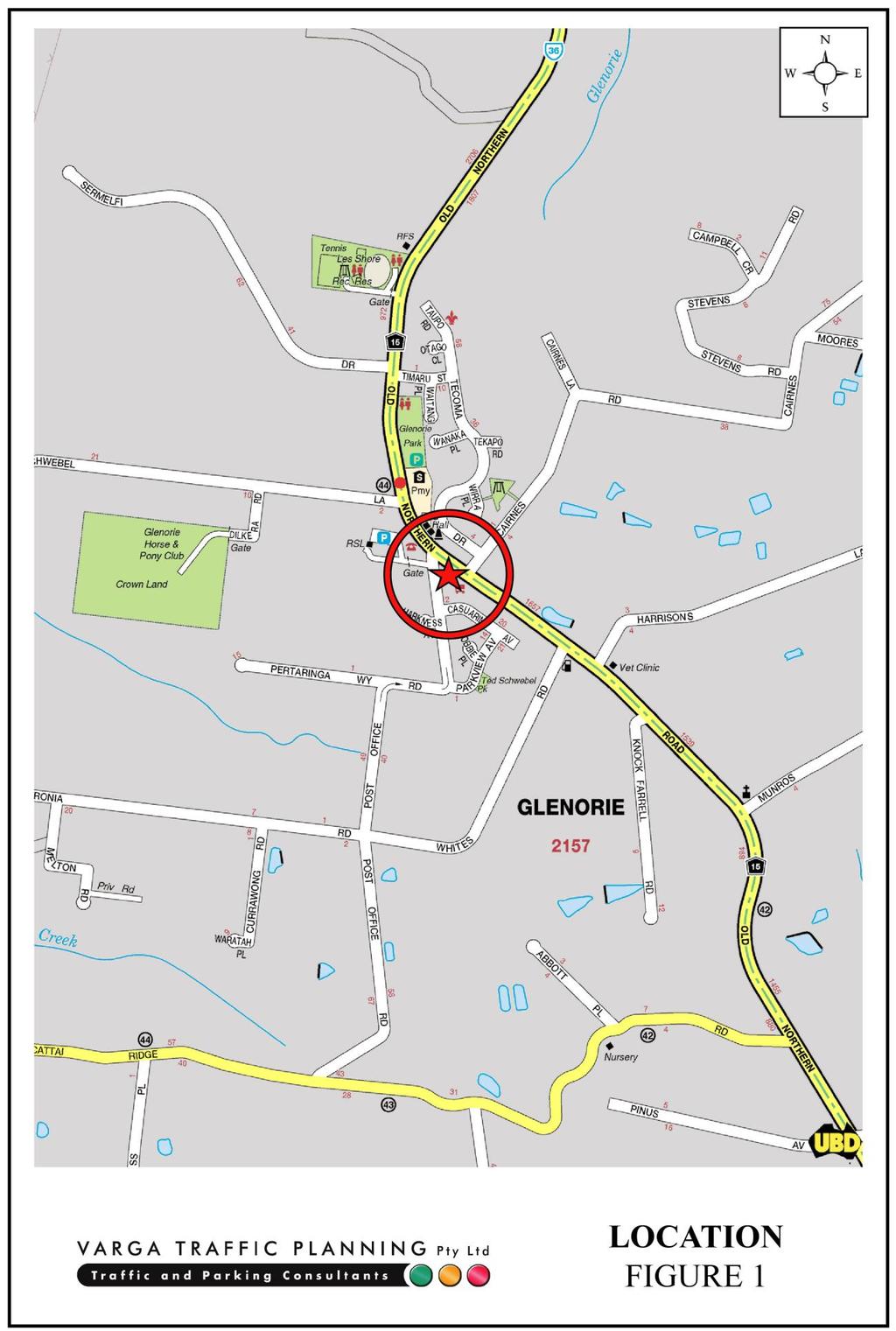
3 1. INTRODUCTION This report has been prepared to accompany a development application to Council for a mixed use development proposal to be located at 930 Old Northern Road & 4 Road, Glenorie (Figures 1 and 2). The proposed development involves the redevelopment of the Glenorie Shopping Village which includes the demolition of the majority of the existing retail shops and commercial suites on the site and the staged construction of a new shop top development. Off-street parking is to be provided over three levels, including two basement levels, with all parking to be constructed during Stage 1 works. The purpose of this report is to assess the traffic and parking implications of the development proposal and to that end this report: describes the site and provides details of the development proposal reviews the road network in the vicinity of the site, and the traffic conditions on that road network estimates the traffic generation potential of the development proposal, and assigns that traffic generation to the road network serving the site assesses the traffic implications of the development proposal in terms of road network capacity reviews the geometric design features of the proposed car parking and loading facilities for compliance with the relevant codes and standards assesses the adequacy and suitability of the quantum of off-street car parking and loading provided on the site. 1
4 2
5 3

6 2. PROPOSED DEVELOPMENT Site The subject site is located on the southern corner of the Old Northern Road and Road intersection and lies within the Glenorie town centre. The site has street frontages approximately 85m in length to Old Northern Road, approximately 170m in length to Post Office Road and occupies an area of approximately 6,387m². A recent aerial image of the site and its surroundings is reproduced below. Source: Nearmap No.930 Old Northern Road is currently occupied by the Glenorie Shopping Village which comprising a number of retail shops including a bakery, butchery, pizzeria, newsagent, Thai restaurant, clothing store, hair dresser and beautician plus a number of commercial suites including a dental clinic, chiropractor and real estate. The cumulative floor area of the existing shopping village is approximately 1,065m². Off-street parking for the existing shopping village is currently provided for 77 cars in an outdoor at-grade car parking area. Vehicular access to the car parking area is provided via separate entry and exit driveways located off Road. 4
7 No.4 Road is currently occupied by a single-storey dwelling house with off-street parking. Vehicular access to the site is provided via a single driveway located in Road. Proposed Development The proposed development involves the redevelopment of the shopping village on the site on the site and the staged construction of a new shop top development. Stage 1 involves the demolition of the existing dwelling house and the southern portion of the existing shopping village building (whilst retaining the northern and western portions), and the construction of a new two-level basement car park, four ground floor retail shops/commercial suites and residential apartments on the two levels above. Stage 2 involves the demolition of the existing northern portion of the existing shopping village building and the construction of a new two-storey building, comprising a retail shop/commercial suite on the ground floor level and a gymnasium on the level above. A total of 20 residential apartments are proposed in the new development as follows: 1 bedroom apartments: 3 2 bedroom apartments: 17 TOTAL APARTMENTS: 20 The cumulative floor area of the non-residential component (including the retail, commercial and gymnasium) is approximately 2,943m 2. Off-street parking is proposed for a total of 164 cars (comprising 41 residential spaces, 8 visitor spaces, 114 non-residential spaces and a carwash bay) over three levels, including two basement levels, with residential parking separated from the non-residential parking. Vehicular access to the car parking facilities is to be provided via a new entry/exit driveway located midway along the Road site frontage, where the site s existing entry-only driveway is located. 5
8 Loading/servicing for the proposed development is expected to be undertaken by a variety of commercial vehicles up to and including 12.5m long heavy rigid trucks (HRV). A loading area is to be located on the ground floor level, in the far southern corner of the site. Vehicular access to the loading bay is to be provided via separate new entry and exit driveways located at the southern end of the Road site frontage. Plans of the proposed development have been prepared by Design Cubicle and are reproduced in the following pages. 6
9 7
10 8
11 9
12 10
13 11
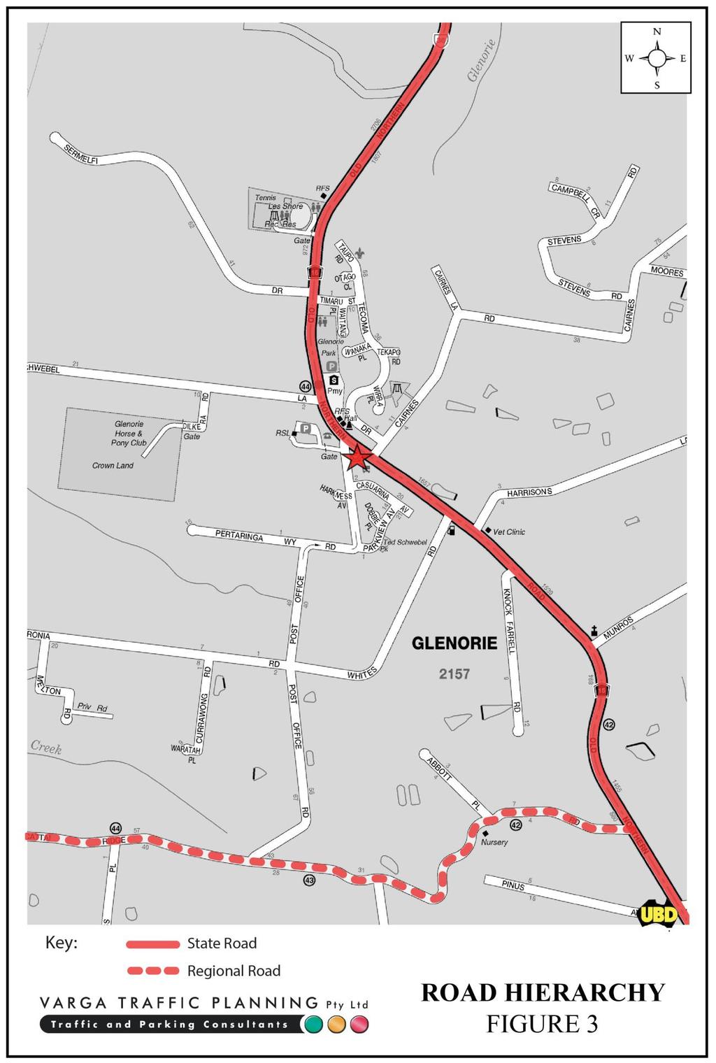
14 3. TRAFFIC ASSESSMENT Road Hierarchy The road hierarchy allocated to the road network in the vicinity of the site by the Roads and Maritime Services is illustrated on Figure 3. Old Northern Road is classified by the RMS as a State Road and provides the key north-south road link in the area, linking Wisemans Ferry and Dural. It typically carries one traffic lane in each direction in the vicinity of the site with turning bays provided at key locations. Kerbside parking is generally prohibited along both sides of the road in the vicinity of the site although is generally permitted further afield. Cattai Ridge Road is classified by the RMS as a Regional Road and provides the key eastwest road link in the area, linking Maraylya and Glenorie. It typically carries one traffic lane in each direction in the vicinity of the site. Road is a local, unclassified road which is primarily used to provide vehicular and pedestrian access to frontage properties. Kerbside parking is generally permitted on both sides of the road. Existing Traffic Controls The existing traffic controls which apply to the road network in the vicinity of the site are illustrated on Figure 4. Key features of those traffic controls are: a 60 km/h SPEED LIMIT which applies to Old Northern Road a 50 km/h SPEED LIMIT which applies to the Road and all other local roads in the area a RIGHT TURN HOLDING BAY for southbound traffic in Old Northern Road turning into Road 12
15 13
16 14
17 GIVE WAY restrictions in Road where it intersects with Old Northern Road. Existing Traffic Conditions An indication of the existing traffic conditions on the road network in the vicinity of the site is provided by detailed peak period traffic surveys undertaken as part of this traffic study. The traffic surveys were undertaken in Old Northern Road at its intersection with Road during the weekday morning and afternoon commuter peak periods. The results of the traffic surveys are reproduced in Appendix A and reveal that: two-way traffic flows in Old Northern Road, south of Road, are typically in the order of 360 vehicles per hour (vph) during the morning on-road peak period, increasing to 550 vph during the afternoon on-road peak period two-way traffic flows in Old Northern Road, north of Road, are typically in the order of 290 vph during the morning on-road peak period, increasing to 380 vph during the afternoon on-road peak period two-way traffic flows in Road at the far northern end, are typically in the order of 190 vph during the morning on-road peak period, increasing to 460 vph during the afternoon on-road peak period. In addition to the above intersection traffic surveys, surveys were also undertaken of the existing shopping village s vehicular access driveways during the weekday morning and afternoon commuter peak periods. The results of the traffic surveys are also reproduced in Appendix A and reveal that: two-way traffic flows into and out of the existing shopping village during the morning on-road peak period was in the order of 44 vph, comprising 25 trips IN and 19 trips OUT. Based on the existing floor area of 1,065m 2, this equates to 1 vehicle trip per 24.2m 2 15
18 two-way traffic flows into and out of the existing shopping village during the afternoon on-road peak period was in the order of 86 vph, comprising 38 trips IN and 48 trips OUT. Based on the existing floor area of 1,065m 2, this equates to 1 vehicle trip per 12.4m 2. Projected Traffic Generation An indication of the traffic generation potential of the development proposal is provided by reference to the former Roads and Maritime Services publication Guide to Traffic Generating Developments, Section 3 - Landuse Traffic Generation (October 2002). The RMS Guidelines are based on extensive surveys of a wide range of land uses and nominates the following traffic generation rates which are applicable to the residential component of the development proposal: Medium Density Residential Flat Buildings peak hour vehicle trips per 1 & 2 bedroom dwelling peak hour vehicle trips per 3 bedroom dwelling In order to determine the traffic generation potential of the non-residential component of the development proposal, reference is made to the traffic generation rates of the existing shopping village i.e. 1 vehicle trip per 24.2m 2 during the morning on-road peak period and 1 vehicle trip per 12.4m 2 during the afternoon on-road peak period. Application of the above traffic generation rates to the various components of the development proposal yields a traffic generation potential of approximately 132 vph during the AM on-road peak period and 247 vph during the PM on-road peak period, as set out below: Projected Traffic Generation Potential AM PM Residential (20 apartments): 10 vph 10 vph Non-residential (2,943m 2 ): 122 vph 237 vph TOTAL TRAFFIC GENERATION POTENTIAL: 132 vph 247 vph 16
19 The abovementioned traffic generation potential of the proposed development assumes that gymnasium s peak operating period coincides with the on-road peak period. Gymnasiums however, tend to be busiest between 6am and 7am and again between 6pm and 7pm i.e. outside the on-road peak period such that the actual traffic generation potential during the on-road peak periods will be less than the figures suggested above. In any event, that projected future level of traffic generation potential should however, be offset or discounted by the volume of traffic associated with the existing shopping village on the site, in order to determine the nett increase in the traffic generation potential expected to occur as a consequence of the development proposal. As noted in the foregoing, traffic surveys undertaken of the existing vehicular access driveways determined that the shopping village generated 44 vph during the AM on-road peak period and 86 vph during the PM on-road peak period. Furthermore, the RMS Guidelines indicates that the existing dwelling house located on the No.4 Road site generates 1 vehicle trip during the AM and PM on-road peak periods. As such, the existing site generates in the order 45 vph during the AM on-road peak period and 87 vph during the PM on-road peak period, as set out below: Existing Traffic Generation AM PM Shopping village (1,065m 2 ): 44 vph 86 vph Dwelling house (1 dwelling): 1 vph 1 vph TOTAL TRAFFIC GENERATION POTENTIAL: 45 vph 87 vph Accordingly, it is likely that the proposed development will result in a nett increase in the traffic generation potential of the site of approximately 87 vph during the AM on-road peak period and 160 vph during the PM on-road peak period, as set out below: Projected Nett Increase in Peak Hour Traffic Generation Potential of the site as a consequence of the development proposal AM PM Projected Future Traffic Generation Potential: 132 vph 247 vph Less Existing Traffic Generation Potential: -45 vph -87 vph NETT INCREASE IN TRAFFIC GENERATION POTENTIAL: 87 vph 160 vph 17
20 That projected increase in the traffic generation potential of the site as a consequence of the development proposal will not have any unacceptable traffic implications in terms of road network capacity, as is demonstrated by the following section of this report. Traffic Implications - Road Network Capacity The traffic implications of development proposals primarily concern the effects that the additional traffic flows generated by the development may have on the operational performance of the adjacent road network. Those effects can be assessed using the SIDRA 7 capacity analysis program as is widely used by the RMS and many LGAs for this purpose. Criteria for evaluating the results of SIDRA capacity analysis are reproduced in the following pages. The results of the SIDRA analysis of the Old Northern Road & Road intersection are summarised on Table 3.1 below, revealing that: the intersection currently operates at Level of Service A, with total average vehicle delays in the order of 3-4 seconds per vehicle under the projected additional traffic flows expected to be generated by the development proposal, the intersection will continue to operate at Level of Service A, with increases in average vehicle delays of less than 1 second/vehicle. In the circumstances, it is clear that the proposed development will not have any unacceptable traffic implications in terms of road network capacity. 18
21 TABLE RESULTS OF SIDRA ANALYSIS OF OLD NORTHERN ROAD & POST OFFICE ROAD Key Indicators Existing Traffic Demand Projected Development Traffic Demand AM PM AM PM Level of Service A A A A Degree of Saturation Average Vehicle Delay (secs/veh) Road (south) L R Old Northern Road (east) L T Old Northern Road (west) T R TOTAL AVERAGE VEHICLE DELAY OLD_POSX OLD_POSP 19
22 Criteria for Interpreting Results of SIDRA Analysis 1. Level of Service (LOS) LOS Traffic Signals and Roundabouts Give Way and Stop Signs 'A' 'B' 'C' 'D' 'E' 'F' Good operation. Good with acceptable delays and spare capacity. Satisfactory. Operating near capacity. At capacity; at signals incidents will cause excessive delays. Roundabouts require other control mode. Unsatisfactory and requires additional capacity. Good operation. Acceptable delays and spare capacity. Satisfactory but accident study required. Near capacity and accident study required. At capacity and requires other control mode. Unsatisfactory and requires other control mode. 2. Average Vehicle Delay (AVD) The AVD provides a measure of the operational performance of an intersection as indicated on the table below which relates AVD to LOS. The AVDs listed in the table should be taken as a guide only as longer delays could be tolerated in some locations (ie inner city conditions) and on some roads (ie minor side street intersecting with a major arterial route). Level of Service Average Delay per Vehicle (secs/veh) Traffic Signals, Roundabout Give Way and Stop Signs A less than 14 Good operation. Good operation. B 15 to 28 Good with acceptable delays and spare Acceptable delays and spare capacity. capacity. C 29 to 42 Satisfactory. Satisfactory but accident study required. D 43 to 56 Operating near capacity. Near capacity and accident study required. E 57 to 70 At capacity; at signals incidents will cause excessive delays. Roundabouts require other control mode. 3. Degree of Saturation (DS) The DS is another measure of the operational performance of individual intersections. At capacity and requires other control mode. For intersections controlled by traffic signals 1 both queue length and delay increase rapidly as DS approaches 1, and it is usual to attempt to keep DS to less than 0.9. Values of DS in the order of 0.7 generally represent satisfactory intersection operation. When DS exceeds 0.9 queues can be anticipated. For intersections controlled by a roundabout or GIVE WAY or STOP signs, satisfactory intersection operation is indicated by a DS of 0.8 or less. 1 The values of DS for intersections under traffic signal control are only valid for cycle length of 120 secs. 20
23 4. PARKING IMPLICATIONS Existing Kerbside Parking Restrictions The existing kerbside parking restrictions which apply to the road network in the vicinity of the site are illustrated on Figure 5 and comprise: NO STOPPING / NO PARKING restrictions in the vicinity of the Old Northern Road and Road intersection generally UNRESTRICTED kerbside parking along both sides of Old Northern Road, east of the site generally UNRESTRICTED kerbside parking along both sides of Road, including along the site frontage BUS ZONES located at regular intervals along both sides of Old Northern Road, including directly outside the site. Off-Street Parking Provisions The off-street parking requirements applicable to the development proposal are specified in The Hill s Development Control Plan 2012 Part C Section 1 Parking document in the following terms: Residential Flat Buildings One bedroom unit: Two or three bedroom unit: Visitors: 1 space per unit 2 spaces per unit 2 spaces per 5 units Commercial Premises (including Business Premises & Office Premises) 1 space per 25m 2 GFA Centre Commercial 1 space per 40m 2 GFA 21
24 22
25 Retail Shops (including Shopping Centres and General Business Retail) 1 space per 18.5m 2 GLFA Gymnasiums/Fitness Centre 1 space per 25m 2 GFA As the precise nature of the retail/commercial tenancies are not yet known, for the purposes of this assessment, the off-street parking rate of 1 space per 25m 2 has been adopted as it represents a middle ground between the abovementioned parking rates. Therefore application of the above parking requirements to the various components outlined in the development proposal yields an off-street parking requirement of 163 parking spaces as set out below: Residential (20 apartments): Visitors: Non-residential (2,943m 2 ): TOTAL: 37 spaces 8 spaces 118 spaces 163 spaces The proposed development makes provision for a total of 164 off-street car parking spaces, comprising 41 residential spaces, 8 visitor spaces, 114 non-residential spaces and a carwash bay, thereby resulting in an overall shortfall of 1 parking space when assessed in accordance with Council s parking code requirements. However, it is noted in this regard that: the peak parking demands generated by the gymnasium will occur early in the morning and later in the evening (i.e. typically between 6am-7am and between 6pm-7pm) and will not coincide with the peak parking demands generated by the other commercial/retail uses on the site a portion of the customers using the proposed shopping village will be drawn from residents living within the apartments above, thereby further reducing the parking demands associated with a stand-alone shopping village. 23
26 The geometric design layout of the proposed car parking facilities have been designed to comply with the relevant requirements specified in the Standards Australia publication Parking Facilities Part 1 - Off-Street Car Parking AS in respect of parking bay dimensions, ramp gradients and aisle widths. Loading/Servicing Provisions The proposed new mixed use building is expected to be serviced by a variety of commercial vehicles up to and including 12.5m long HRV trucks. A loading area is to be located on the ground floor level, in the far southern corner of the site. The manoeuvring area has been designed to accommodate the swept turning path requirements of these 12.5m heavy rigid trucks, allowing them to enter and exit the site in a forward direction at all times. In summary, the proposed parking and loading facilities satisfy the relevant requirements specified in Council s Parking Code as well as the Australian Standards and it is therefore concluded that the proposed development will not have any unacceptable parking or loading implications. 24
27 APPENDIX A TRAFFIC SURVEY DATA
28 Client Job No/Name Day/Date R.O.A.R. DATA Reliable, Original & Authentic Results PEDS WEST SOUTH EAST PEDS WEST SOUTH EAST Old Northern Old Northern Old Northern Old Northern Ph , Fax Time Per TOT Peak Per TOT Mobile : Varga Traffic Planning : 6017 GLENORIE : Tuesday 17th May PEAK HR Per End 33 Lights WEST SOUTH EAST Heavies WEST SOUTH EAST Combined WEST SOUTH EAST Old Northern Old Northern Old Northern Old Northern Old Northern Old Northern Time Per T R L R L T TOT Time Per T R L R L T TOT Time Per T R L R L T TOT Per End Per End Per End Lights WEST SOUTH EAST Heavies WEST SOUTH EAST Combined WEST SOUTH EAST Old Northern Old Northern Old Northern Old Northern Old Northern Old Northern Peak Per T R L R L T TOT Peak Per T R L R L T TOT Peak Per T R L R L T TOT PEAK HR PEAK HR PEAK HR
29 R.O.A.R. DATA Reliable, Original & Authentic Results PEDS WEST SOUTH EAST PEDS WEST SOUTH EAST Ph , Fax Time Per Old Northern Old Northern Old Northern Old Northern TOT Peak Per TOT Mobile Client : Varga Traffic Planning Job No/Name : 6017 GLENORIE Day/Date : Tuesday 17th May PEAK HR Per End Lights WEST SOUTH EAST Heavies WEST SOUTH EAST Old Northern Old Northern Old Northern Old Northern Combined WEST SOUTH EAST Old Northern Old Northern Time Per T R L R L T TOT Time Per T R L R L T TOT Time Per T R L R L T TOT Per End Per End Per End Lights WEST SOUTH EAST Heavies WEST SOUTH EAST Combined WEST SOUTH EAST Old Northern Old Northern Old Northern Old Northern Old Northern Old Northern Peak Per T R L R L T TOT Peak Per T R L R L T TOT Peak Per T R L R L T TOT PEAK HR PEAK HR PEAK HR
30 R.O.A.R. DATA Client : Varga Traffic Planning Reliable, Original & Authentic Results Job No/Name : 6017 GLENORIE Ph , Fax , Mob Day/Date : Tuesday 17th May 2016 N Intersection Details Obtained via satellite May be incorrect AM PEAK HOUR Combined figures only Old Northern T AM PM R T PM AM PM AM L R L Old Northern PM PEAK HOUR Weather >>>
31 R.O.A.R. DATA Reliable, Original & Authentic Results PEDS NORTH EAST SOUTH PEDS NORTH EAST SOUTH Ph , Fax Time Per Nth D-Way TOT Peak Per Nth D-Way TOT Mobile Client : Varga Traffic Planning In Job No/Name : 6017 GLENORIE Other Day/Date : Tuesday 17th May Table PEAK HR Per End 17 Lights NORTH EAST SOUTH Heavies NORTH EAST SOUTH Nth D-Way Nth D-Way Time Per T L R L R T TOT Time Per T L R L R T TOT Time Per T L R L R T TOT Per End Per End Per End Lights NORTH EAST SOUTH Heavies NORTH EAST Nth D-Way Nth D-Way SOUTH Combined NORTH EAST SOUTH Nth D-Way Combined NORTH EAST SOUTH Nth D-Way Peak Per T L R L R T TOT Peak Per T L R L R T TOT Peak Per T L R L R T TOT PEAK HR PEAK HR PEAK HR
32 R.O.A.R. DATA Reliable, Original & Authentic Results PEDS NORTH EAST SOUTH PEDS NORTH EAST SOUTH Ph , Fax Nth D-Way Nth D-Way Time Per TOT Peak Per TOT Mobile Client : Varga Traffic Planning In Job No/Name : 6017 GLENORIE Other Day/Date : Tuesday 17th May Table PEAK HR Per End Lights NORTH EAST SOUTH Heavies NORTH EAST SOUTH Combined NORTH EAST SOUTH Nth D-Way Nth D-Way Nth D-Way Time Per T L R L R T TOT Time Per T L R L R T TOT Time Per T L R L R T TOT Per End Per End Per End Lights NORTH EAST SOUTH Heavies NORTH EAST SOUTH Combined NORTH EAST SOUTH Nth D-Way Nth D-Way Nth D-Way Peak Per T L R L R T TOT Peak Per T L R L R T TOT Peak Per T L R L R T TOT PEAK HR PEAK HR PEAK HR
33 R.O.A.R. DATA Client : Varga Traffic Planning Reliable, Original & Authentic Results Job No/Name : 6017 GLENORIE Ph , Fax , Mob Day/Date : Tuesday 17th May 2016 N Intersection Details Obtained via satellite May be incorrect No signage or line markings AM PEAK HOUR Combined figures only T L AM PM R 1 3 PM AM PM 74 5 AM T R L 0 0 North Driveway PM PEAK HOUR Weather >>>
34 R.O.A.R. DATA Reliable, Original & Authentic Results PEDS NORTH EAST SOUTH PEDS NORTH EAST SOUTH Ph , Fax Time Per Sth D-Way TOT Peak Per Sth D-Way TOT Mobile Client : Varga Traffic Planning Job No/Name : 6017 GLENORIE Day/Date : Tuesday 17th May PEAK HR Per End 14 Lights NORTH EAST SOUTH Heavies NORTH EAST SOUTH Sth D-Way Sth D-Way Time Per T L R L R T TOT Time Per T L R L R T TOT Time Per T L R L R T TOT Per End Per End Per End Lights Combined NORTH EAST SOUTH Sth D-Way NORTH EAST SOUTH Heavies NORTH EAST SOUTH Combined NORTH EAST SOUTH Sth D-Way Sth D-Way Sth D-Way Peak Per T L R L R T TOT Peak Per T L R L R T TOT Peak Per T L R L R T TOT PEAK HR PEAK HR PEAK HR
35 R.O.A.R. DATA Reliable, Original & Authentic Results PEDS NORTH EAST SOUTH PEDS NORTH EAST SOUTH Ph , Fax Time Per Sth D-Way TOT Peak Per Sth D-Way TOT Mobile Client : Varga Traffic Planning Job No/Name : 6017 GLENORIE Day/Date : Tuesday 17th May PEAK HR Per End Lights NORTH EAST SOUTH Heavies NORTH EAST SOUTH Combined NORTH EAST SOUTH Sth D-Way Sth D-Way Sth D-Way Time Per T L R L R T TOT Time Per T L R L R T TOT Time Per T L R L R T TOT Per End Per End Per End Lights NORTH EAST SOUTH Heavies NORTH EAST SOUTH Combined NORTH EAST SOUTH Sth D-Way Sth D-Way Sth D-Way Peak Per T L R L R T TOT Peak Per T L R L R T TOT Peak Per T L R L R T TOT PEAK HR PEAK HR PEAK HR
36 R.O.A.R. DATA Client : Varga Traffic Planning Reliable, Original & Authentic Results Job No/Name : 6017 GLENORIE Ph , Fax , Mob Day/Date : Tuesday 17th May 2016 N Intersection Details Obtained via satellite May be incorrect No signage or line markings AM PEAK HOUR Combined figures only T L 44 1 AM 96 0 PM 85 1 PM 64 2 AM T R R PM AM L 15 0 South Driveway PM PEAK HOUR Weather >>>
CVS Derwood. Local Area Transportation Review
 CVS Derwood Montgomery County, Maryland May 27, 2016 Local Area Transportation Review Prepared for: JC Bar Properties, Inc. Steve Fleming, PE 415 Fallowfield Road, Suite 301 Camp Hill, Pennsylvania 17011
MEMORANDUM. The study area of the analysis was discussed with City staff and includes the following intersections:
 MEMORANDUM DATE: JULY 6, 2012 TO: FROM: RE: CC: MELANIE KNIGHT BRAD BYVELDS/ JENNIFER LUONG 1050 SOMERSET STREET PRELIMINARY TRAFFIC ANALYSIS OUR FILE NO. 111152 NEIL MALHOTRA The purpose of this memo
NATHAN HALE HIGH SCHOOL PARKING AND TRAFFIC ANALYSIS. Table of Contents
 Parking and Traffic Analysis Seattle, WA Prepared for: URS Corporation 1501 4th Avenue, Suite 1400 Seattle, WA 98101-1616 Prepared by: Mirai Transportation Planning & Engineering 11410 NE 122nd Way, Suite
JEP John E. Jack Pflum, P.E. Consulting Engineering 7541 Hosbrook Road, Cincinnati, OH Telephone:
 JEP John E. Jack Pflum, P.E. Consulting Engineering 7541 Hosbrook Road, Cincinnati, OH 45243 Email: jackpflum1@gmail.com Telephone: 513.919.7814 MEMORANDUM REPORT Traffic Impact Analysis Proposed Soccer
WEBER ROAD RESIDENTIAL DEVELOPMENT Single Family Residential Project
 WEBER ROAD RESIDENTIAL DEVELOPMENT Single Family Residential Project WEBER ROAD RESIDENTIAL DEVELOPMENT TRAFFIC IMPACT STUDY TABLE OF CONTENTS 1.0 Executive Summary Page 2.0 Introduction 2.1 DEVELOPMENT
Trip Generation Study: A 7-Eleven Gas Station with a Convenience Store Land Use Code: 945
 Trip Generation Study: A 7-Eleven Gas Station with a Convenience Store Land Use Code: 945 Introduction The Brigham Young University Institute of Transportation Engineers student chapter (BYU ITE) completed
Market Street PDP. Nassau County, Florida. Transportation Impact Analysis. VHB/Vanasse Hangen Brustlin, Inc. Nassau County Growth Management
 Transportation Impact Analysis Market Street PDP Nassau County, Florida Submitted to Nassau County Growth Management Prepared for TerraPointe Services, Inc. Prepared by VHB/Vanasse Hangen Brustlin, Inc.
Parking Regulations Dundas Street West, from Bathurst Street to Dovercourt Road
 STAFF REPORT ACTION REQUIRED Parking Regulations Dundas Street West, from Bathurst Street to Dovercourt Road Date: October 28, 2008 To: From: Toronto and East York Community Council Director, Transportation
HALFF 16196? TRAFFIC MANAGEMENT PLAN. Richardson ISD Aikin Elementary School Dallas, Texas North Bowser Road Richardson, Texas 75081
 30280 16196? TRAFFIC MANAGEMENT PLAN Exhibit 572B Aikin Elementary School Planned Development District No. 572 Approved City Plan Commission October20, 2016 July 12, 2016 Prepared for HALFF AVO 31586 PHO1
TRAFFIC IMPACT STUDY. Platte Canyon Villas Arapahoe County, Colorado (Arapahoe County Case Number: Z16-001) For
 For") TRAFFIC IMPACT STUDY For Platte Canyon Villas Arapahoe County, Colorado (Arapahoe County Case Number: Z16-001) February 2015 Revised: August 2015 April 2016 July 2016 September 2016 Prepared for: KB Home
TRAFFIC IMPACT STUDY For Platte Canyon Villas Arapahoe County, Colorado (Arapahoe County Case Number: Z16-001) February 2015 Revised: August 2015 April 2016 July 2016 September 2016 Prepared for: KB Home
FARM 1065 PORTION 1, ATLANTIS TRAFFIC IMPACT ASSESSMENT
 FARM 1065 PORTION 1, ATLANTIS TRAFFIC IMPACT ASSESSMENT February 2018 FIRST ISSUE Prepared by: JG AFRIKA (PTY) LTD Branch: Cape Town PO Box 38561 Postal code: 7430 Telephone: 021 530 1800 Email: wink@
MADISON, WI STONE HOUSE DEVELOPMENT 1000 E. WASHINGTON AVENUE REDEVELOPMENT TRANSPORTATION STUDY DECEMBER 14, 2015
 MADISON, WI STONE HOUSE DEVELOPMENT 1000 E. WASHINGTON AVENUE REDEVELOPMENT TRANSPORTATION STUDY DECEMBER 14, 2015 TABLE OF CONTENTS... 3 Proposed Development... 3 Methodology... 3 Phase 1 Development...
Traffic Impact Study
 Traffic Impact Study Statham DRI One University Parkway Prepared for: Barrow County Prepared by: October 2012 Table of Contents Executive Summary i Section 1. Introduction 1 Project Description 1 Methodology
TRAFFIC IMPACT STUDY MANUFACTURING COMPANY
 TRAFFIC IMPACT STUDY For MANUFACTURING COMPANY Prepared For: Airway Heights, WA Prepared By: SUNBURST ENGINEERING, P. S. 4310 S. Ball Dr. Veradale, WA 99037 April, 2013 TRAFFIC IMP ACT STUDY Manufacturing
Speed Limit Review. Montague Road, West End. Prepared for Brisbane City Council CEB06842 CEB06842
 Speed Limit Review Montague Road, West End CEB06842 CEB06842 Prepared for Brisbane City Council 2 November 2016 Speed Limit Review Montague Road, West End Document Information Prepared for Brisbane City
Marking Scheme Field Work. 6 International Geography Olympiad. Brisbane
 Marking Scheme Field Work th 6 International Geography Olympiad Brisbane June 2006 Question - Map - 7 Marks Mark out of 4 and divide by 2 at the end. (Sample map was provided to markers.) Shading according
Date: April 3, 2018 Revised May 15, Project #: Re: Burlington Mall Retail Collection Transportation Evaluation
 To: Chuck Schneider Burlington S&S, LLC 225 West Washington Street Indianapolis, IN 46204 From: Patrick Dunford, P.E. Senior Project Manager Date: April 3, 2018 Revised May 15, 2018 Project #: 13482.01
Snow and Ice Control POLICY NO. P-01/2015. CITY OF AIRDRIE Snow and Ice Control Policy
 Page 1 CITY OF AIRDRIE Snow and Ice Control Effective Date: Approved By: Approved On: March 17, 2015 City Council March 16, 2015 Revision Date: Resolution #: ------ PURPOSE: The City of Airdrie is responsible
Section 14F Purpose of the Wairakei Residential Zone
 Section 14F 14F Purpose of the Wairakei Residential Zone The purpose of the Wairakei Residential Zone is to provide for an intensified urban character within Papamoa East. The zone recognises Wairakei
FINAL Traffic Report for the Proposed Golden Valley Road and Newhall Ranch Road Projects in the City of Santa Clarita, California May 5, 2005
 FINAL Traffic Report for the Proposed Golden Valley Road and Newhall Ranch Road Projects in the City of Santa Clarita, California May 5, 2005 Prepared For: EDAW, Inc. 1420 Kettner Boulevard, Suite 620
Appendixx C Travel Demand Model Development and Forecasting Lubbock Outer Route Study June 2014
 Appendix C Travel Demand Model Development and Forecasting Lubbock Outer Route Study June 2014 CONTENTS List of Figures-... 3 List of Tables... 4 Introduction... 1 Application of the Lubbock Travel Demand
April 10, Mr. Curt Van De Walle, City Manager City of Castle Hills 209 Lemonwood Drive Castle Hills, Texas 78213
 Mr. Curt Van De Walle, City Manager City of Castle Hills 209 Lemonwood Drive Castle Hills, Texas 78213 Subject: Revised Castle Hills BASIS Charter School Traffic Impact Analysis Review City of Castle Hills,
VHD Daily Totals. Population 14.5% change. VMT Daily Totals Suffolk 24-hour VMT. 49.3% change. 14.4% change VMT
 6.9 Suffolk 6-54 VMT Population and Travel Characteristics Population 14.5% change 2014 1,529,202 VHD Daily Totals 2014 251,060 49.3% change 2040 1,788,175 2040 374,850 VMT Daily Totals 2014 39,731,990
City of Camrose Winter Road Maintenance Policy
 City of Camrose Winter Road Maintenance Policy The purpose of this policy is to outline the level of service that the City of Camrose delivers regarding the maintenance of roads in winter conditions. 1.
PW 001 SNOW REMOVAL AND SANDING FOR ROADWAYS AND SIDEWALKS October 6, 2014 (#223-14) Original October 19, 2015; October 15, 2018 Public Works
 Original October 19, 2015; October 15, 2018 Public Works") Policy Statement: The Village of Kitscoty will provide snow and ice control on municipal streets and sidewalks according to determined priorities. Purpose: To provide direction and information to employees
Policy Statement: The Village of Kitscoty will provide snow and ice control on municipal streets and sidewalks according to determined priorities. Purpose: To provide direction and information to employees
PLAZA MEXICO RESIDENCES
 PLAZA MEXICO RESIDENCES TRAFFIC STUDY PREPARED FOR: 3000 E. IMPERIAL, LLC. 6940 Beach Boulevard, D-501 Buena Park, California 90621 PREPARED BY: OCTOBER 5, 2017 translutions the transportatio n solutions
COUNCIL POLICY MANUAL
 COUNCIL POLICY MANUAL SECTION: PUBLIC WORKS SUBJECT: SNOW & ICE CONTROL POLICY 2012/2013 GOAL: Pages: 1 of 10 Approval Date: Dec. 3, 2012 Res. # 1001/2012 To annually identify the winter maintenance costs
MEMORANDUM. Trip Generation Analysis
 MEMORANDUM To: RMC Architects From: Matthew Palmer, PE Subject: Trip Generation, Parking Analysis & Level of Service Project: Port of Everett, GTC #13-053 Date: August 25, 2014 The trip generation and
III. FORECASTED GROWTH
 III. FORECASTED GROWTH In order to properly identify potential improvement projects that will be required for the transportation system in Milliken, it is important to first understand the nature and volume
I. M. Schoeman North West University, South Africa. Abstract
 Urban Transport XX 607 Land use and transportation integration within the greater area of the North West University (Potchefstroom Campus), South Africa: problems, prospects and solutions I. M. Schoeman
City of Hermosa Beach Beach Access and Parking Study. Submitted by. 600 Wilshire Blvd., Suite 1050 Los Angeles, CA
 City of Hermosa Beach Beach Access and Parking Study Submitted by 600 Wilshire Blvd., Suite 1050 Los Angeles, CA 90017 213.261.3050 January 2015 TABLE OF CONTENTS Introduction to the Beach Access and Parking
Table of Contents Introduction... 4 Study Area... 5
 Table of Contents Introduction... 4 Study Area... 5 Streets and s... 5 Traffic Volumes... 8 Recent and Anticipated Development... 10 Crash Analysis... 10 Projected Traffic Volumes... 11 Trip Generation...
Roadway Traffic Noise Feasibility Assessment. 315 Chapel Street. Ottawa, Ontario
 Roadway Traffic Noise Feasibility Assessment 315 Chapel Street Ottawa, Ontario REPORT: GWE17-002 - Traffic Noise Prepared For: Leanne Moussa Allsaints 10 Blackburn Avenue K1N 6P8 Ottawa, Ontario Prepared
KAISER SOUTH NORTHERN VIRGINIA HUB TRAFFIC IMPACT STUDY PRINCE WILLIAM COUNTY, VIRGINIA TABLE OF CONTENTS. Section 2 BACKGROUND INFORMATION 12
 KAISER SOUTH NORTHERN VIRGINIA HUB TRAFFIC IMPACT STUDY PRINCE WILLIAM COUNTY, VIRGINIA TABLE OF CONTENTS Page EXECUTIVE SUMMARY 1 Purpose of Report and Study Objectives... 1 Site Location and Study Area...
IV. ENVIRONMENTAL IMPACT ANALYSIS B. AESTHETICS SHADE/SHADOW
 IV. ENVIRONMENTAL IMPACT ANALYSIS B. AESTHETICS SHADE/SHADOW 1. INTRODUCTION Potential effects of the Proposed Project related to visual character, views and light/glare are addressed in Section IV.A,
October 16, Dear Mr. Hawkins:
 IBI GROUP 101 410 Albert Street Waterloo ON N2L 3V3 Canada tel 519 585 2255 fax 519 585 2269 October 16, 2017 Mr. Trevor Hawkins Manager of Applications and Implementation Integrated Planning and Public
Focused Traffic Analysis for the One Lincoln Park Project
 September 15, 2015 Mr. Bill Johnson Coldwell Banker 511 Sir Francis Drake Boulevard Greenbrae, CA 94904 Focused Traffic Analysis for the One Lincoln Park Project Dear Mr. Johnson; As requested, W-Trans
Appendix C Traffic Study
 Final Environmental Impact Statement Appendix C Traffic Study Schofield Generating Station Project, Hawaii October 2015 C-1 Final Environmental Impact Statement This page intentionally left blank. Schofield
Local Area Key Issues Paper No. 13: Southern Hinterland townships growth opportunities
 Draft Sunshine Coast Planning Scheme Review of Submissions Local Area Key Issues Paper No. 13: Southern Hinterland townships growth opportunities Key Issue: Growth opportunities for Southern Hinterland
City of Saginaw Right of Way Division Snow and Ice Removal Policy January 18, 2016
 Snow and Ice Removal Policy January 18, 2016 It is the policy of the to provide snowplowing and ice removal services in order to: Provide safe traveling conditions for motorists and pedestrians Assist
Appendix B. Traffic Analysis Report
 Appendix B Traffic Analysis Report Report No. 14369/TR/WN02 August 2007 SALLINS BYPASS BYPASS OPTIONEERING ANALYSIS - TRAFFIC REPORT Kildare County Council Áras Chill Dara, Devoy Park, Naas, Co Kildare
SNOW REMOVAL - REQUEST FOR PROPOSAL. Snow Removal/Clearing and Sanding/Salting for Winter Fundy Ocean Research Center for Energy
 Fundy Ocean Research Center for Energy SNOW REMOVAL - REQUEST FOR PROPOSAL Snow Removal/Clearing and Sanding/Salting for Winter 2016-17 Sites 1. FORCE Sub-Station Driveway (portion of Old Black Rock Road),
Prepared for. 3D/International, Inc West Loop South, Suite 400 Houston, Texas November 2006
 DRAFT TRAFFIC IMPACT STUDY FOR PHASED DEVELOPMENT OF TAMU CC Prepared for 3D/International, Inc. 1900 West Loop South, Suite 400 Houston, Texas 77027 November 2006 Interim Review Only Document Incomplete:
CITY OF NEW LONDON WINTER ROAD & SIDEWALK MAINTENANCE POLICY
 CITY OF NEW LONDON WINTER ROAD & SIDEWALK MAINTENANCE POLICY GENERAL The purpose of this policy is to set up acceptable procedures and policies for the winter maintenance of public areas in the City of
SHADE/SHADOW REPORT. For the Proposed 8777 Washington Project. Culver City, CA. Prepared for:
 SHADE/SHADOW REPORT For the Proposed 8777 Washington Project Culver City, CA Prepared for: VITRUVIAN CULVER CITY LLC (THE APPLICANT) 5822 WEST WASHINGTON BOULEVARD CULVER CITY, CALIFORNIA 90232 Prepared
APPENDIX I - AREA PLANS
 ROUTE 37 WEST LAND USE PLAN ROUTE 37 WEST LAND USE PLAN Recent land use decisions and development trends have drawn attention to the land within the Route 37 western by-pass area between Route 50 and
2267 N o r t h 1500 W C l i n t o n U T 84015
 P l a n n i n g C o m m i s s i o n M e m b e r s C h a i r J a c o b B r i g g s V i c e C h a i r G a r y T y l e r T o n y T h o m p s o n J o l e n e C r e s s a l l A n d y H a l e D e r e c k B a
TOWN OF WINCHESTER OFFICE OF THE PLANNING DEPARTMENT. 71 Mount Vernon Street. Winchester, MA 01890
 BRIAN SZEKELY TOWN PLANNER Winchester Board of Selectmen 71 Mt. Vernon St. Winchester, MA 01890 TOWN OF WINCHESTER OFFICE OF THE PLANNING DEPARTMENT 71 Mount Vernon Street Winchester, MA 01890 August 11,
Travel Demand Management Plan
 Travel Demand Management Plan Tryg s & Apartment Building 8 West Lake Street Minneapolis, MN AUTHORIZED PROPERTY REPRESENTATIVE: By Dated: Mr. Johnny Carlson Trammell Crow Chicago Development, Inc. 5 South
Noise Feasibility Study Proposed Residential Development (Infill) 747 Liverpool Road Pickering, Ontario
 747 Liverpool Road Pickering, Ontario") Noise Feasibility Study Proposed Residential Development (Infill) 747 Liverpool Road Pickering, Ontario Prepared for: Madison Liverpool Limited 369 Rimrock Road Toronto, Ontario, M3J 3G2 Prepared by Victor
Noise Feasibility Study Proposed Residential Development (Infill) 747 Liverpool Road Pickering, Ontario Prepared for: Madison Liverpool Limited 369 Rimrock Road Toronto, Ontario, M3J 3G2 Prepared by Victor
ALTA VISTA COMMERCIAL/ RESIDENTIAL PROJECT
 ALTA VISTA COMMERCIAL/ RESIDENTIAL PROJECT TRAFFIC IMPACT ANALYSIS Prepared For: Paul Conzelman SC Development 2151 Michelson Drive, Suite 140 Irvine, CA 92612 Prepared By: 2030 Main Street, Suite 1200
STAFF REPORT ACTION REQUIRED
 STAFF REPORT ACTION REQUIRED Appeal by Fast Signs of the Decision of the Chief Building Official for One Variance Respecting a Proposed First Party Wall Sign 10-21 Four Seasons Place Date: January 18,
Response to the Local Government Boundary Commission for England proposals for new electoral arrangements for Leeds City Council
 Response to the Local Government Boundary Commission for England proposals for new electoral arrangements for Leeds City Council This is the Leeds Liberal Democrat response to the Draft Recommendations
SHADOW IMPACT STUDY REPORT
 SHADOW IMPACT STUDY REPORT 175 Zoo Park Road Town of Wasaga Beach Date: September 2017 Prepared for: Simcoe County Housing Corporation Prepared by: MacNaughton Hermsen Britton Clarkson Planning Limited
January 12, Mr. Ryan Granger TMGB Wilson, LLC 2221 Health Drive SW, Suite 2200 Wyoming, Michigan 49519
 January 12, 2018 Mr. Ryan Granger TMGB Wilson, LLC 2221 Health Drive SW, Suite 2200 Wyoming, Michigan 49519 Re: Proposed Reserve at Rivertown Mixed-Use Development Updated Trip Generation and Site Driveway
TRANSPORTATION AND TRAFFIC ANALYSIS REPORT
 Square One Drive Extension Municipal Class Environmental Assessment Environmental Study Report Appendix B Transportation and Traffic Analysis Report TRANSPORTATION AND TRAFFIC ANALYSIS REPORT FINAL DRAFT
TRAFFIC IMPACT STUDY
 TRAFFIC IMPACT STUDY TERRE HAUTE CONVENTION CENTER WABASH AVENUE & 9 TH STREET TERRE HAUTE, INDIANA PREPARED FOR 8365 Keystone Crossing, Suite 201 Indianapolis, IN 46240 Phone: (317) 202-0864 Fax: (317)
Roadway Traffic Noise Feasibility Assessment. Conservancy Subdivision. Ottawa, Ontario
 Conservancy Subdivision Ottawa, Ontario REPORT: GWE17 151 Traffic Noise Prepared For: Andrew Finnson Barrhaven Conservancy East Inc. Ottawa, Ontario Prepared By: Joshua Foster, P.Eng., Principal Omar Daher,
SHADOW STUDY REPORT REGARDING
 SHADOW STUDY REPORT REGARDING an APPLICATION TO REDEVELOP Three 6 Storey Condominiums Regional Road 25 (Ontario Street) and Britannia Road Milton, Ontario KNYMH FILE # 17030 Prepared by: Krista Lilley
5.1 Introduction. 5.2 Data Collection
 Chapter 5 Traffic Analysis 5.1 Introduction This chapter of the EIS assesses the traffic impacts of the proposed N5 Westport to Turlough Road Project (the proposed scheme). The proposed scheme will provide
Feasibility Noise Assessment. Westgate Shopping Centre Redevelopment. Ottawa, Ontario
 Feasibility Noise Assessment Westgate Shopping Centre Redevelopment Ottawa, Ontario REPORT: GWE15-067 - Feasibility Noise Prepared For: Stuart Craig 2300 Yonge Street, Suite 500 Toronto, Ontario M4P 1E4
Policy Title: Snow Removal & Ice Control Policy #: PW
 Village of Fruitvale Corporate Policy Manual Policy Title: Snow Removal & Ice Control Policy #: PW-2012-01 Section: PUBLIC WORKS Initially Approved: 2012 06 04 Last Reviewed: 2013 05 06 Council Approval:
ARTICLE 8. USES 8.0 GENERAL USE PERMISSION 8.1 USE MATRIX 8.2 PRINCIPAL USE STANDARDS 8.3 TEMPORARY USE STANDARDS
 ARTICLE 8. USES 8.0 GENERAL USE PERMISSION 8.1 USE MATRIX 8.2 PRINCIPAL USE STANDARDS 8.3 TEMPORARY USE STANDARDS 8.0 GENERAL USE PERMISSION No structure or land may be used or occupied except in conformity
Proposed restaurant with drive-through facility and residential development on land at Peniel Green Road, Birchgrove, Swansea TRANSPORT ASSESSMENT
 SRT Development Ltd Proposed restaurant with drive-through facility and residential development on land at Peniel Green Road, Birchgrove, Swansea TRANSPORT ASSESSMENT October 2017 Applicant: SRT Development
Trip and Parking Generation Study of Orem Fitness Center-Abstract
 Trip and Parking Generation Study of Orem Fitness Center-Abstract The Brigham Young University Institute of Transportation Engineers student chapter (BYU ITE) completed a trip and parking generation study
Date: June 19, 2013 Meeting Date: July 5, Consideration of the City of Vancouver s Regional Context Statement
 Section E 1.5 To: From: Regional Planning and Agriculture Committee Lee-Ann Garnett, Senior Regional Planner Planning, Policy and Environment Department Date: June 19, 2013 Meeting Date: July 5, 2013 Subject:
Metro Emergency Security Operations Center (ESOC) 410 Center Street City of Los Angeles
 410 Center Street City of Los Angeles") Metro Emergency Security Operations Center (ESOC) 410 Center Street City of Los Angeles Traffic Study August 31, 2015 AECOM 515 South Flower Street, 4 th Floor Los Angeles, CA 90071 Job Number: 60323255
Metro Emergency Security Operations Center (ESOC) 410 Center Street City of Los Angeles Traffic Study August 31, 2015 AECOM 515 South Flower Street, 4 th Floor Los Angeles, CA 90071 Job Number: 60323255
Appendix I: Traffic Study
 City of Fontana Sierra Lakes Commerce Center Draft EIR Appendix I: Traffic Study FirstCarbon Solutions H:\Client (PN JN)\0144\01440050\EIR\1 ADEIR\01440050 Sec99 99 Appendix Dividers.doc THIS PAGE INTENTIONALLY
Richborough Estates Ltd. Land South of Monmouth Road, Raglan. Transport Assessment
 Richborough Estates Ltd Land South of Monmouth Road, Raglan Transport Assessment PTB Transport Planning Ltd Radclyffe House 66/68 Hagley Road Edgbaston Birmingham West Midlands B16 8PF T/F. 0121 454 5530
Traffic Impact Analysis. for the STARBUCKS STORE. Located at 9900 BALBOA BOULEVARD. Submitted to CITY OF LOS ANGELES. January 2017.
 Traffic Impact Analysis for the STARBUCKS STORE Located at 9900 BALBOA BOULEVARD Submitted to CITY OF LOS ANGELES January 2017 Submitted By January 5, 2017 Ken A. Aitchison, P.E. Transportation Engineering
California Urban Infill Trip Generation Study. Jim Daisa, P.E.
 California Urban Infill Trip Generation Study Jim Daisa, P.E. What We Did in the Study Develop trip generation rates for land uses in urban areas of California Establish a California urban land use trip
TREASURE COAST REGIONAL PLANNING COUNCIL M E M O R A N D U M. To: Council Members AGENDA ITEM 4B10
 TREASURE COAST REGIONAL PLANNING COUNCIL M E M O R A N D U M To: Council Members AGENDA ITEM 4B10 From: Date: Subject: Staff December 14, 2018 Council Meeting Local Government Comprehensive Plan Review
The Highline Development Traffic Impact Study
 The Highline Development Traffic Impact Study Columbia Falls, Montana Prepared For: TD&H Engineering 450 Corporate Drive, Suite 101 Kalispell, MT 59901 June, 2018 130 South Howie Street Helena, Montana
CHAPTER 3. CAPACITY OF SIGNALIZED INTERSECTIONS
 CHAPTER 3. CAPACITY OF SIGNALIZED INTERSECTIONS 1. Overview In this chapter we explore the models on which the HCM capacity analysis method for signalized intersections are based. While the method has
6 th Line Municipal Class Environmental Assessment
 6 th Line Municipal Class Environmental Assessment County Road 27 to St John s Road Town of Innisfil, ON September 6, 2016 APPENDIX L: TRAVEL DEMAND FORECASTING MEMORANDUM Accessible formats are available
Transportation Noise Assessment. 560 Rideau Street. Ottawa, Ontario
 Transportation Noise Assessment 560 Rideau Street Ottawa, Ontario REPORT: GWE13-034 Transportation Noise Prepared For: Kevin Yemm Richcraft Group of Companies 2280 St. Laurent Boulevard, Suite 201 Ottawa,
Waikato District Plan. Plan Change document
 Waikato District Plan Plan Change 17 Ngaruawahia and Surrounding Villages Stage One Proposed Rezoning Plan Change document Throughout this document text OR maps referred to in the text underlined in red
Parking areas in all zoning districts shall comply with the following standards:
 Part 13, Off-Street Parking and Loading 1300. Applicability. Off-street parking spaces shall be provided in accordance with the specifications in this Part in any district whenever any new use is established
SUBJECT: SUMMARY OF FINDINGS. October 29, Mr. Carter Redish Carter Group Architects, Inc S. El Camino Real, Suite F San Clemente, CA 92672
 October 29, 2018 Mr. Carter Redish Carter Group Architects, Inc. 1810 S. El Camino Real, Suite F San Clemente, CA 92672 SUBJECT: CANYON STEEL FOCUSED TRAFFIC IMPACT ANALYSIS Dear Mr. Carter Redish: Urban
SWDP Hearing Statement Matter F Development at North East Malvern (SWDP 56)
") SWDP Hearing Statement Matter F Development at North East Malvern (SWDP 56) Town and Country Planning Act 1990 Planning and Compulsory Purchase Act 2004 Localism Act 2011 On Behalf Of: Halkin Developments
SWDP Hearing Statement Matter F Development at North East Malvern (SWDP 56) Town and Country Planning Act 1990 Planning and Compulsory Purchase Act 2004 Localism Act 2011 On Behalf Of: Halkin Developments
Final City of Colusa STREETS & ROADWAYS MASTER PLAN. October J Street Suite 390 Sacramento, CA 95814
 Final City of Colusa STREETS & ROADWAYS MASTER PLAN October 2009 660 J Street Suite 390 Sacramento, CA 95814 TABLE OF CONTENTS I. INTRODUCTION... 1 Report Organization...1 II. ANALYSIS METHODOLOGY... 2
Establishment of Local Trip Generation Rates or Equations for Mixed-Use Developments in Kansas
 Report No. K-TRAN: KU-11-7 FINAL REPORT October 2012 Establishment of Local Trip Generation Rates or Equations for Mixed-Use Developments in Kansas Mehrdad Givechi, P.E., PTOE George Sarkodee The University
Winning Farm of Winchester
 Winning Farm of Winchester Planning Board Presentation Winning Farm of Winchester 12.9 acres of undeveloped forest on the former Winning Farm site Located north of Thornberry Road in the northwestern corner
Town of Bowden Province of Alberta Policy Document ( ) SNOW REMOVAL POLICY
 SNOW REMOVAL POLICY") Town of Bowden Box 338, 2101 20 th Ave Bowden, Alberta, T0M 0K0 Town of Bowden Province of Alberta Policy Document (2019-01) SNOW REMOVAL POLICY 1 INTRODUCTION The purpose of this policy is to establish
Town of Bowden Box 338, 2101 20 th Ave Bowden, Alberta, T0M 0K0 Town of Bowden Province of Alberta Policy Document (2019-01) SNOW REMOVAL POLICY 1 INTRODUCTION The purpose of this policy is to establish
CITY OF ORILLIA POLICY MANUAL. Winter Operations. Table of Contents. WINTER CONTROL Objectives 2. WINTER CONTROL Season 3
 Page 1 of 12 Winter Operations Table of Contents WINTER CONTROL Objectives 2 WINTER CONTROL Season 3 SNOW ACCUMULATION Road Plowing 4,5 ICY ROADWAYS Application of Deicers/Abrasives 6 SNOW ACCUMULATION
Noise Maps, Report & Statistics, Dublin City Council Noise Mapping Project Roads and Traffic Department
 Noise Maps, Report & Statistics, Dublin City Council Noise Mapping Project Roads and Traffic Department Produced by Traffic Noise & Air Quality Unit November 2007 Contact: brian.mcmanus@dublincity.ie Ph;
Urban development. The compact city concept was seen as an approach that could end the evil of urban sprawl
 The compact city Outline 1. The Compact City i. Concept ii. Advantages and the paradox of the compact city iii. Key factor travel behavior 2. Urban sustainability i. Definition ii. Evaluating the compact
Regal House #CREATESOMETHING. ALL ENQUIRIES 53,647 sq.ft. RE-DEVELOPMENT OPPORTUNITY SUITABLE FOR A VARIETY OF USES OFFICE HOTEL RESIDENTIAL
 SK1 3AA #CREATESOMETHING RE-DEVELOPMENT OPPORTUNITY OFFICE HOTEL RESIDENTIAL Stockport has everything Excellent motorway access First class rail links Efficient local bus services Easy access to Manchester
Expanding the GSATS Model Area into
 Appendix A Expanding the GSATS Model Area into North Carolina Jluy, 2011 Table of Contents LONG-RANGE TRANSPORTATION PLAN UPDATE 1. Introduction... 1 1.1 Background... 1 1.2 Existing Northern Extent of
6711 LEE HIGHWAY TRAFFIC IMPACT STUDY ARLINGTON, VIRGINIA
 6711 TRAFFIC IMPACT STUDY ARLINGTON, VIRGINIA Prepared for: NVR, Inc. Prepared by: Wells + Associates, Inc. Michael J. Workosky, PTP, TOPS, TSOS John J. Andrus William L. Zeid, PE 703.917.6620 May 4, 2017
SNOW REMOVAL GUIDE. City Of Orange Township. Public Works Snow Removal Hotline: (973) My Orange Hotline: (973)
 My Orange Hotline: (973)") Mayor Dwayne D. Warren, Esq. And The Orange Municipal Council MOVING ORANGE FORWARD City Of Orange Township SNOW REMOVAL GUIDE Public Works Snow Removal Hotline: (973) 266-4030 My Orange Hotline: (973)
Mayor Dwayne D. Warren, Esq. And The Orange Municipal Council MOVING ORANGE FORWARD City Of Orange Township SNOW REMOVAL GUIDE Public Works Snow Removal Hotline: (973) 266-4030 My Orange Hotline: (973)
CITY OF MINOT SNOW REMOVAL PLAN October 2018
 CITY OF MINOT SNOW REMOVAL PLAN October 2018 1.0 GENERAL This plan has been written to provide information regarding snow removal procedures and policies. The plan provides guidance, while maintaining
ZONING. 195 Attachment 1
 ZONING 195 Attachment 1 Use Regulation Schedule Town of Chelmsford [Amended 10-16-2000 ATM by Art. 20; 5-3-2001 ATM by Art. 17; 10-15-2001 ATM by Art. 22; 4-29-2002 ATM by Art. 22; 10-24-2002 ATM by Art.
WOODRUFF ROAD CORRIDOR ORIGIN-DESTINATION ANALYSIS
 2018 WOODRUFF ROAD CORRIDOR ORIGIN-DESTINATION ANALYSIS Introduction Woodruff Road is the main road to and through the commercial area in Greenville, South Carolina. Businesses along the corridor have
CITY OF BEAVER DAM SNOW & ICE REMOVAL POLICY
 CITY OF BEAVER DAM SNOW & ICE REMOVAL POLICY Revised January, 2016 Approved by Operations Committee: February 1, 2016 This snow and ice removal policy guides Public Works personnel with deicing, plowing,
OXFORD HEIGHTS SUBDIVISION EMERGENCY EVACUATION PLAN
 OXFORD HEIGHTS SUBDIVISION EMERGENCY EVACUATION PLAN March 27, 2007 Oxford Heights Overview and Historical Conditions Oxford Heights is a medium sized community located on the southern side of Elizabeth
RE: Existing and Future Parking Demand Analysis St. Joseph Center Expansion
 HAND DELIVERED December 12, 2003 Mr. James S. Bancroft Chair, Board of Directors St. Joseph Center 204 Hampton Drive Venice, California 90291-8633 RE: Existing and Future Parking Demand Analysis St. Joseph
Contents. Ipswich City Council Ipswich Adopted Infrastructure Charges Resolution (No. 1) Page
 Page") Ipswich City Council Ipswich Adopted Infrastructure Charges Resolution (No. 1) 2014 Contents Page Part 1 Introduction 3 1. Short title 3 2. Commencement 3 3. Sustainable Planning Act 2009 3 4. Purpose
Ipswich City Council Ipswich Adopted Infrastructure Charges Resolution (No. 1) 2014 Contents Page Part 1 Introduction 3 1. Short title 3 2. Commencement 3 3. Sustainable Planning Act 2009 3 4. Purpose
225 Bush Street Suite 1700 San Francisco, CA phone fax
 225 Bush Street Suite 1700 San Francisco, CA 94104 415.896.5900 phone 415.896.0332 fax www.esassoc.com memorandum date July 29, 2009 to from subject Craig Nikitas, San Francisco Planning Department Daniel
Introduction / Background
 TECHNICAL NOTE 4 Proposed Redevelopment of the Former Leyland Test Track Site, Leyland Planning Application Reference 07/2017/3361/ORM CT/15043/TN04 Rev B 11 October 2018 Introduction / Background 1. A