THE GLOBAL EARTHQUAKE MODEL (GEM) CARIBBEAN REGIONAL PROGRAMME AN INTRODUCTION
|
|
|
- Liliana Reynolds
- 5 years ago
- Views:
Transcription

1 THE GLOBAL EARTHQUAKE MODEL (GEM) CARIBBEAN REGIONAL PROGRAMME AN INTRODUCTION A presentation by Dr. Myron W. Chin PhD, CEng, FICE, FIStructE, FAPETT GEM OPERATIONAL MANAGER FOR THE CARIBBEAN SEISMIC RESEARCH CENTRE, UWI at the APETT CIVIL ENGINEERING DIVISION SEMINAR Port Authority Conference Room, Port of Spain Trinidad 31 st January 2012 Copyright Myron Chin 2011
2 SUMMARY OF PRESENTATION - INTRODUCTORY REMARKS - TYPES OF NATURAL HAZARDS IN THE CARIBBEAN - SOME EXAMPLES OF DAMAGE DONE BY RECENT EARTHQUAKES - LAUNCH OF GEM CARIBBEAN REGIONAL PROGRAMME (GCRP) - FORMATION OF SEVEN REGIONAL WORKING GROUPS (WGs) - SOME OF PROPOSED RESEARCH PROJECTS OF WGs - ACTIVE FAULTS CENTRAL RANGE FAULT, T&T - BUILDING CODE FOR T&T - BUILDING INVENTORY - SOME EXAMPLES OF THE POTENTIAL USE OF GEM TOOLS - CONCLUDING REMARKS
3 INTRODUCTORY REMARKS The entire Caribbean Basin is prone to socio-natural and man-made disasters ECLAC estimates that the disaster impact is over 1.5 billion US dollars/year A number of national, regional (ODPM, CDEMA, SRC, ACS) and international organizations (PAHO, OAS) are currently working in this area. Now we have GEM
4 Caribbean Natural Hazards Geological: Earthquakes Volcanic activity Tsunamis Landslides Meteorological: Hurricanes Storm surge and wave action Torrential rains
5 Caribbean plate (after Weber) Tobago
6 Vertical neotectonics (tilting)(after Weber) Ca-SA: 20 mm/yr


7 El Pilar fault historic + instrumental earthquakes (6.8) Mendoza (2000)


8 Perez et al NA 17 N sana san a MAR CARIBE NA sana FMMF SF FS VENEZUELA PF FP 0 mm/a CANOA20 VENEZUELA 20 mm/yr -74 W
9
10 MAJOR FAULTS IN TRINIDAD AND TOBAGO (After Lloyd Lynch)
 2007 6.6 (VIII) 1825 7 (VII) 1888 7.3 (VIII) 1918 6.3 (VIII) 1954 6.5 5.9 6.7 (VIII) 1997 6.7 6.1 6.2 6.3 53 5.")
11 Trinidad and Tobago Damaging Earthquakes Size, Intensity, Chronology and Locations (after Lloyd Lynch) 7.8 (IX) 1766 Seismic Energy 7.4 (VI) (VIII) (VII) (VIII) (VIII) (VIII)


")


12 Recent Seismic Hazard Map of Trinidad (after Lloyd Lynch)
13 TOBAGO EARTHQUAKE OF (After Joan Latchman)
14 14
15 Justification for Concern about Natural Hazards ( As stated by Tony Gibbs) Rising insurance premiums Vulnerable tourism facilities Special concerns of small island states Destructive recent Hurricanes and Earthquakes
16 SOME EXAMPLES OF EARTHQUAKE DAMAGE IN THE CARIBBEAN REGION -TOBAGO EARTHQUAKES &22 -MAGNITUDE 5.6 & 6.1 -LANDSLIDE IN TOBAGO AND SAN SOUCI DUE TO HEAVY RAINS MUD VOLCANO IN PIPARO -DOMINICA EARTHQUAKE MAGNITUDE 6.0 -HAITI EARTHQUAKE MAGNITUDE 7.0
17 TYPICAL DAMAGE TOBAGO EARTHQUAKE OF (MAGNITUDE 5.6) (Photo courtesy Dr. Joan Latchman)
18


19
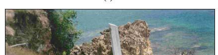
20 LANDSLIDE AT SAN SOUCI (PHOTO COURTESY S. LALLA)
21 LANDSLIDE AT SAN SOUCI (PHOTO COURTESY S. LALLA)


")
22 MUD VOLCANO AT PIPARO (Photo courtesy of GSTT)
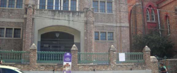
23 TYPICAL DAMAGE -1 DOMINICA EARTHQUAKE OF ( MAGNITUDE 6.0) Portsmouth Methodist Church Recreational Centre (Photos courtesy Dr. R. Clarke)
24 TYPICAL DAMAGE -2- DOMINICA EARTHQUAKE OF Portsmouth Methodist Church Recreational Centre (Photo courtesy Dr. R. Clarke)
25 TYPICAL DAMAGE -3- DOMINICA EARTHQUAKE OF Portsmouth RC Church Front Wall and Corners Collapse (Photo courtesy Dr. R. Clarke)


26 TYPICAL DAMAGE -4- DOMINICA EARTHQUAKE OF Portsmouth RC Church Close-up of Collapse(Photo courtesy Dr. R. Clarke)


27 TYPICAL DAMAGE -5 FLAT ROOF COLLAPSE HAITI EARTHQUAKE OF (7.0 MAG.) (Photo courtesy Dr. R. Clarke)


")
28 TYPICAL DAMAGE -6 OUT OF PLANE COLLAPSE HAITI EARTHQUAKE OF (Photo courtesy Dr. R. Clarke) (Photo courtesy Dr. R. Clarke)
29 TYPICAL DAMAGE -7 FAILURE OF COLUMNS HAITI EARTHQUAKE OF (Photo courtesy Dr. D. Gay)
30 THE GLOBAL EARTHQUAKE MODEL (GEM) A collaborative effort devised and launched by OECD s Global Science Forum, aimed at engaging the global community in the design, development and deployment of uniform open standards and tools for earthquake risk assessment worldwide


31 PUBLIC-PRIVATE PARTNERSHIP 10 countries have adhered so far discussions and negotiations are ongoing with 15+ others private organisations g have 7p partnered up with GEM so far they contribute 13.6 M Euro the OECD,, World Bank,, UNESCO,, UN/ISDR, IAEE and IASPEI are associate participants

32 SCIENTIFIC FRAMEWORK OF GEM Decision Making Tools Con ngency Planning, Territorial Planning, Cost BenefitAnal ysis, Ri sk Governance etc. Risk and Impact Analysis Damage and loss maps, loss exceedance curves, risk indicators, indirect losses, impact on society/ economy Hazard Probability, Intensity, Loca on Exposure Value, Loca on; Physical, Social, Economic Vulnerability Physical, Social, Economic, Ins tu onal; Func ons, Indicators
33 FIRST PRODUCTS What is? OpenQuake is an open source software application that allows users to compute seismic hazard and risk on any scale, developed as an open source project, available for download from
34 ROLE OF GEM S EXECUTIVE COMMITTEE IN BRINGING ACTIVITIES OF VARIOUS COMPONENTS TOGETHER

35 STAY UPDATED GEM Website Most update source of information News, results, calls, GEM Report 2009/2010 v2 Available from website and hard-copy GEM Brochure Available from website and hard-copy Bi-monthly e-newsletter Sign-up at website
36 LAUNCH OF GEM CARIBBEAN PROGRAMME -The development of Regional Programmes (RPs) is the main mechanism through which the GEM tools will be transferred with a view to creating a uniform globally used standard. The RPs involve local experts using GEM software and tools, who generate local data and validate the data and standards that are being created on the global level. -The Institution i of Structural Engineers (Caribbean Division) hosted a presentation of the GEM project at the Normandie Hotel in Trinidad on 15 October 2010.
37 LAUNCH OF GEM CARIBBEAN REGIONAL PROGRAMME (Cont ed) -In January 2011, the GEM Foundation (hereinafter referred to as GEM) engaged The Seismic Research Centre (SRC) of The University of the West Indies, St. Augustine, to promote the GEM vision in the Caribbean. Funding became available in March 2011 at which time the GEM Operational Manager, Dr. Myron Chin, was appointed. He will, in collaboration with all players/stakeholders from the Caribbean community, spearhead the implementation of the GEM initiative in the Insular Caribbean and the effective functioning of the GEM Regional Programme (RP) for the Caribbean
38 HIGHLIGHTS OF GEM THREE-DAY WORKSHOP- MAY 2-4,2011 TO LAUNCH GEM REGIONAL PROGRAMME IN THE CARIBBEAN -OPENED BY HON. MINISTER OF SCIENCE, TECHNOLOGY AND TERTIARY EDUCATION - PRESENTATIONS BY DRS. RUI PINHO,MARCO PAGANI AND HELEN CROWLEY OF GEM SECRETARIAT AND TWENTY OTHERS -ACTIVE PARTICIPATION BY SOME 68 PARTICIPANTS FROM NINE CARIBBEAN COUNTRIES - SEVEN REGIONAL WORKING GROUPS FORMED - FULL DETAILS OF WORKSHOP CAN BE FOUND AT:
39 HON. MINISTER FAZAL KARIM OPENS GEM WORKSHOP


40 PRESENTATION BY DR. RUI PINHO SECRETARY-GENERAL OF GEM
41 PRESENTATION BY DR. MARCO PAGANI GEM CO-ORDINATOR FOR HAZARD


42 PRESENTATION BY DR. HELEN CROWLEY GEM COORDINATOR FOR RISK
43 GEM WORKSHOP 2-4 MAY 2011 GROUP PHOTOGRAPH
44 GEM CARIBBEAN SEVEN REGIONAL WORKING GROUPS HAZARD- OVERALL CO-ORDINATOR Dr. Walter Salazar (Co-opted opted on ) 05 19) Group 1: Active Faults Project Leader: Rafi Ahmed (MONA GEOINFORMATICS UWI MONA, JAMAICA) Participants: Franck kaudemard dy Luz Rodríguez (FUNVISIS, S Venezuela) Lyndon Brown (Earthquake Unit, UWI Mona, Jamaica), Wayne Adams (Consultant Jamaica) Barbara Carby (DRRC, UWI Mona, Jamaica) Joan Latchman SRC, UWI, Trinidad Enrique Arango, CENAIS, Mexico Krishna Persad, Krishna Persad & Assoc. Ltd, Trinidad
45 Paleoseismology: locked or creeping CRF?(after Weber) Prentice et al (2001) (2001, 2002)
46 CENTRAL RANGE FAULT (AFTER WEBER)
47 CENTRAL RANGE FAULT (AFTER WEBER) Holocene FAULT 2002 Trench 9
48 Trinidad and Tobago Pipeline Network (after Lloyd Lynch)
49 GEM CARIBBEAN -7 REGIONAL WORKING GROUPS (Cont ed) RISK- OVERALL CO-ORDINATOR -Dr. Myron Chin Group 5: Exposure Leaders of Sub-Groups: Building Codes: Carlos Buron Critical Facilities: Wayne Adams Retrofitting: Didier Deris Expert E tjudgement: Anthony Farrell Building Inventory: Kevin Granger Members: JacobOpadeyi, JanVermeiren Vermeiren, CassandraLa Barrie, Mona GeoInformatics ( Sub-group co-opted on ) Databases: Myron Chin, SRC, UWI, Trinidad Members:to be co-opted by Leaders of Groups/SubGroups
50 DEVELOPMENT OF CARIBBEAN RISK ATLAS FOR DEVELOPMENT OF CARIBBEAN RISK ATLAS FOR EARTHQUAKE HAZARDS (RISK ATLAS PROJECT)
51 DEVELOPMENT OF CARIBBEAN RISK ATLAS FOR EARTHQUAKE HAZARDS (RISK ATLAS PROJECT) Project Manager: U.W.I Disaster Risk Reduction Centre (DRRC) at Mona, UWI in Jamaica. Main Sponsor: World Bank Completion Date: December 2011.
52 OBJECTIVES To develop a methodology for seismic risk assessment in the Caribbean for three pilot States: Jamaica, Grenada and Barbados. To provide guidelines and open-source software for the estimation of earthquake loss using available socio-economic data.
53 Project Components Seismic hazard assessment for Jamaica in terms of PGA and spectral ordinates for 0.2s and 1.0s For Barbados and Grenada: we will use the seismic hazard results of the Eastern Caribbean Project (SRC/EUCENTRE). Development/Adapted Fragility Curves Modification, testing ti and validation of ELE software Determination of data requirements and collection of geo-referenced data Risk evaluation
54 VULNERABILITY AND BUILDING STOCK


55 SURVEY ON DECEMBER Kingston Precast houses Masonry Houses Reinforced concrete apartments Modern Reinforced Concrete Building at New Kingston Historical Buildings Reinforced concrete buildings on slopes Wooden house


56 DEVELOPMENT OF FRAGILITY CURVES FOR pre-cast thouses Heavy roof Connections between panels are effected by welding together matching metal angle sections embedded in the edge ribs of the panels.
57 FUTURE WORK GEM collaboration: - Collaboration with GEM in terms of assistance with the OpenQuake software development. - Two of our Research Assistants from SRC spent two months at the GEM Headquarters from end August to end October 2011 to learn about OpenQuake and to analyse the data collected under the DRRC Risk Atlas Project in order to assess its applicability to the Caribbean Region.


58 GROUP 5 EXPOSURE BUILDING CODES ONE GEM PROJECT IS A NATIONAL BUILDING CODE FOR T&T
59 GROUP 5 EXPOSURE BUILDING INVENTORY LEADER KEVIN GRANGER Project objectives 1. Develop a Crowdsourcing model which is appropriate to this Region and in keeping with GEM Standards. Crowdsourcing refers to the act of outsourcing tasks, traditionally performed by employees or contracted labour, to a relatively undefined, large group of people or community (a crowd ), through an open call. I have chosen to refine this Wikipedia definition to include the word relatively as the intention of this project is to break up the crowd into two categories. The Bounded Crowd will be those participators who will not have any specific experience in structural data collection and will be limited in the data that they can submit. These participators will be responsible for creating the Level 1 attributes as defined in the GEM Taxonomy. Level 1 attributes will be those attributes that are easily observable and will also include remote sensing, rapid assessments by municipalities (admin staff), engineers, architects, technicians, and social scientists. The Unbounded Crowd will therefore be those participators who will have had sufficient experience in structural data collection techniques to be responsible for submitting Level 2 attributes. These attributes will contain detailed structural and non-structural information obtained from a detailed building assessment by a qualified engineer. Partnership with GEM appointed agencies/tools or other groups like UShahidi hidi (see would allow us to create a web-based system that can assemble rank and filter the input from the crowd and present weighted results.
60 GEM CARIBBEAN -7 REGIONAL WORKING GROUPS (Cont ed) Group 6: Vulnerability Tentative Leader: Dr. R. Clarke Members: -Col. Dave Williams, Mr. Allan Stewart, Grisel Morejon, CENAIS, Cuba, Jillian St. Bernard, SRC, UWI Leader of Sub-Group: Tony Gibbs -Effectiveness of Compliance Mechanisms Members: - Didier Deris, Jan Vermeiren Group 7: Socio-Economic Impact (SEI)- OVERALL CO-ORDINATOR Myron Chin Leader of Sub-Group:- Jan Vermeiren -Disaster Financing: Members-Didier Deris, C. Rogers, Tony Gibbs, Fernando Guasch, CENAIS, Cuba - Valuation real estate Leader of fsub-group: Stacey Edwards d (C Co-opted tdby MChi) M. Chin) - Education and Outreach - Members: Alia Juman, SRC, UWI, Ibia Vega, CENAIS, Cuba
61 SOME EXAMPLES OF POTENTIAL USE OF GEM TOOLS AND MODELS IN THE CARIBBEAN. GEM s model and tools are envisaged to support a wide range of users, both from the public and private sectors, regional and national organizations, non-governmental bodies and also individuals id in earthquake prone areas. The following examples are some of the potential use of GEM tools and models:- A country s Minister of Planning and Development may wish to find out how the effect of different possible earthquake scenarios might affect the Gross Domestic Product (GDP) of the country. A national disaster organization would like to see the expected distribution of damage and fatalities within an urban area for a selected scenario earthquake for emergency management planning. A reinsurer or national primary insurer would like to calculate the average annual loss and probable maximum loss to a portfolio of buildings (based on their own input exposure data). A geologist would like to carry out a new tectonic analysis in proximity to a dam, and would like to download data on active faults as a starting point for his/her study. An engineer who is working on the design of a bridge located in a zone of seismic activity, would like to obtain uniform hazard spectra at different return periods for different performance limit states. An individual would like to understand how hazardous the area is, where (s)he is planning to build a house.
62 CONCLUDING REMARKS In concluding this Presentation, it is appropriate to make the following remarks- -GEM IS A GLOBAL ATTEMPT AT COLLABORATIVE DEVELOPMENT OF OPEN-SOURCE SOFTWARE, TRANSPARENT TOOLS AND MODELS FOR EARTHQUAKE RISK ASSESSMENT WORLDWIDE BY INVOLVING EXPERTS AND PROFESSIONALS FROM ALL REGIONS OF THE WORLD AND AS SUCH PROVIDES A CATALYST FOR EARTHQUAKE RISK REDUCTION NOT ONLY IN THE CARIBBEAN BUT THROUGHOUT THE REST OF THE WORLD -GEM IS NOT A VEHICLE TO CARRY OUT THE WORK OF MAJOR INSURANCE/REINSURANCE COMPANIES - GEM CARIBBEAN RP PROVIDES AN OPPORTUNITY TO BRING TOGETHER EARTHQUAKE RISK REDUCTION PROFESSIONALS FROM THE CARIBBEAN REGION TO WORK TOGETHER IN ADAPTING THE TOOLS AND MODELS DEVELOPED BY GEM SO THAT EARTHQUAKE RISK CAN BE BETTER ASSESSED IN THE VARIOUS ISLANDS OF THE CARIBBEAN.
63
DEVELOPMENT OF CARIBBEAN RISK ATLAS FOR EARTHQUAKE HAZARDS (RISK ATLAS PROJECT)
") DEVELOPMENT OF CARIBBEAN RISK ATLAS FOR EARTHQUAKE HAZARDS (RISK ATLAS PROJECT) Walter Salazar, Richard Robertson, Machel Higgins, Cassandra La Barrie, Lloyd Lynch, Joan Latchman, Alia Juman, Jillian Bernard
DEVELOPMENT OF CARIBBEAN RISK ATLAS FOR EARTHQUAKE HAZARDS (RISK ATLAS PROJECT) Walter Salazar, Richard Robertson, Machel Higgins, Cassandra La Barrie, Lloyd Lynch, Joan Latchman, Alia Juman, Jillian Bernard
STATUS OF HAZARD MAPS VULNERABILITY ASSESSMENTS AND DIGITAL MAPS
 JapanInternational Cooperation Agency STATUS OF HAZARD MAPS VULNERABILITY ASSESSMENTS AND DIGITAL MAPS ANGUILLA REPORT THE CARIBBEAN DISASTER EMERGENCY RESPONSE AGENCY () Table of Contents Page Preface
Disaster Risk Assessment: Opportunities for GIS and data management with Open DRI
 Disaster Risk Assessment: Opportunities for GIS and data management with Open DRI Jacob Opadeyi Department of Geomatics Engineering and Land Management, The University of the West Indies, St. Augustine,
Potential Earthquake Risk Reduction Opportunities for GEM Caribbean Programme
 Potential Earthquake Risk Reduction Opportunities for GEM Caribbean Programme THREE-DAY REGIONAL WORKSHOP TO LAUNCH GEM CARIBBEAN REGIONAL PROGRAMME KAPOK HOTEL, PORT OF SPAIN, TRINIDAD 2 ND TO 4 TH MAY
Revealing the interaction between Society and Nature. DesInventar, disaster inventories for damage and loss assessment
 UNFCCC Regional expert meeting on a range approaches to address loss and damage associated with the adverse effects climate change, including impacts related to extreme weather events and slow onset events
Strategic Framework on Geospatial Information and Services for Disasters Relevance for the Americas Region
 Strategic Framework on Geospatial Information and Services for Disasters Relevance for the Americas Region Seventh Session of the Committee of Experts on UN-GGIM Side Event --- UN Headquarters, New York
Baldwin County, Alabama
 2015 Baldwin County, Alabama Multi-Hazard Mitigation Plan I. Comprehensive Plan A multi-jurisdiction plan City of Bay Minette City of Daphne Town of Elberta City of Fairhope City of Foley City of Gulf
Investigation, assessment and warning zonation for landslides in the mountainous regions of Vietnam
 Investigation, assessment and warning zonation for landslides in the mountainous regions of Vietnam (State-Funded Landslide Project SFLP) Dr. Eng. Le Quoc Hung Add: 67 Chien Thang Street, Ha Dong District,
Shake, Rattle n Roll! Earthquake Science & Safety. STACEY EDWARDS Education Officer The University of the West Indies Seismic Research Centre
 Shake, Rattle n Roll! Earthquake Science & Safety STACEY EDWARDS Education Officer The University of the West Indies Seismic Research Centre User Notes This presentation may contain animations, video clips
Experiences on Data and Observational Requirements in the Caribbean
 Experiences on Data and Observational Requirements in the Caribbean UNFCCC Expert Workshop on Methods & Tools and on Data & Observations under the NWP on Impacts, Vulnerability & Adaptation to Climate
Why data? Climate Monitoring, Sectoral Applications and More
 Why data? Climate Monitoring, Sectoral Applications and More Part 2 Adrian R. Trotman Chief, Applied Meteorology and Climatology Caribbean Institute for Meteorology and Hydrology CAMI Funded by the European
Characteristics and introduction of Earthquake in Asia-Pacific region
 Characteristics and introduction of Earthquake in Asia-Pacific region 1906 San Francisco 2011 Tohoku 1999 Chi-Chi 1985 Mexico City 2004 Sumatra Chung-Han Chan 詹忠翰 2011 Christchurch To understand the characteristics
Climate Resilience Decision Making Framework in the Caribbean. A case of Spatial Data Management
 Climate Resilience Decision Making Framework in the Caribbean A case of Spatial Data Management Bishwa Pandey Sr. Data Management Specialist The World Bank Background The mission of The World Bank s Latin
Professor Simon Mitchell, BSc Hull, PhDLiverpool Acting Head of Unit
 EARTHQUAKE UNIT Professor Simon Mitchell, BSc Hull, PhDLiverpool Acting Head of Unit introduction The Earthquake Unit (EQU) is a research unit in the Department of Geography and Geology that is funded
GEONETCast Future Plans at CIMH
 GEONETCast Future Plans at CIMH Operations, Training, Climate Monitoring and Disaster Preparedness WORLD METEOROLOGICAL ORGANIZATION COORDINATION GROUP ON SATELLITE DATA REQUIREMENTS FOR REGION III AND
VULNERABILITY OF WATER SUPPLY TO NATURAL HAZARDS IN JAMAICA
 VULNERABILITY OF WATER SUPPLY TO NATURAL HAZARDS IN JAMAICA RAFI AHMAD rafi.ahmad@uwimona.edu.jm Unit for disaster studies, Department of Geography & Geology, The University of the West Indies, Mona Kingston
Earthquakes Science & Safety. Dr. Richard Robertson Geologist & Head Seismic Research Unit
 Earthquakes Science & Safety Dr. Richard Robertson Geologist & Head Seismic Research Unit Summary The Eastern Caribbean islands are in a seismically active part of the world. Earthquake safety tips should
Earthquakes Science & Safety. Ms Joan L. Latchman Seismologist Seismic Research Unit
 Earthquakes Science & Safety Ms Joan L. Latchman Seismologist Seismic Research Unit Summary Trinidad lies in an area of high earthquake activity for the Caribbean. Earthquake safety tips should be practiced
Interpretive Map Series 24
 Oregon Department of Geology and Mineral Industries Interpretive Map Series 24 Geologic Hazards, and Hazard Maps, and Future Damage Estimates for Six Counties in the Mid/Southern Willamette Valley Including
National Disaster Management Centre (NDMC) Republic of Maldives. Location
 Republic of Maldives. Location") National Disaster Management Centre (NDMC) Republic of Maldives Location Country Profile 1,190 islands. 198 Inhabited Islands. Total land area 300 sq km Islands range b/w 0.2 5 sq km Population approx.
National Disaster Management Centre (NDMC) Republic of Maldives Location Country Profile 1,190 islands. 198 Inhabited Islands. Total land area 300 sq km Islands range b/w 0.2 5 sq km Population approx.
Initiative. Country Risk Profile: papua new guinea. Better Risk Information for Smarter Investments PAPUA NEW GUINEA.
 Pacific Catastrophe Risk Assessment And Financing Initiative PAPUA NEW GUINEA September 211 Country Risk Profile: papua new is expected to incur, on average, 85 million USD per year in losses due to earthquakes
Progress on the Development of the Strategic Framework on Geospatial Information and Services for Disasters
 Progress on the Development of the Strategic Framework on Geospatial Information and Services for Disasters Dr. Peter N. Tiangco Administrator, NAMRIA, Philippines Co-chair, Working Group on Geospatial
Pacific Catastrophe Risk Assessment And Financing Initiative
 Pacific Catastrophe Risk Assessment And Financing Initiative TUVALU is expected to incur, on average,. million USD per year in losses due to earthquakes and tropical cyclones. In the next 5 years, has
ACTION PLAN FOR WORLD HERITAGE IN LATIN AMERICA AND THE CARIBBEAN ( )
") Annex ACTION PLAN FOR WORLD HERITAGE IN LATIN AMERICA AND THE CARIBBEAN (2014-2024) The current Regional Action Plan for Latin America and the Caribbean for 2014-2024 has been elaborated by the State Parties
Annex ACTION PLAN FOR WORLD HERITAGE IN LATIN AMERICA AND THE CARIBBEAN (2014-2024) The current Regional Action Plan for Latin America and the Caribbean for 2014-2024 has been elaborated by the State Parties
UN-GGIM:Americas Regional Report
 UN-GGIM:Americas Regional Report 2016-2017 Seventh Session of UN-GGIM 2-4 August 2017, United Nations Headquarters, New York. Rolando Ocampo President of UN-GGIM: Americas Content Activities, Areas of
Disaster Risk Management in India. Kamal Kishore New Delhi, 27 October 2016
 Disaster Risk Management in India Kamal Kishore New Delhi, 27 October 2016 Hazard, Exposure and Vulnerability Disaster Prevention Mitigation Hurricane Matthew: Cuba & Haiti Emergency Response Coordination
Briefing. H.E. Mr. Gyan Chandra Acharya
 Briefing by H.E. Mr. Gyan Chandra Acharya Under-Secretary-General and High Representative for the Least Developed Countries, Landlocked Developing Countries and Small Island Developing States Briefing
XXII GENERAL ASSEMBLY OF MINISTERS AND MAXIMUM AUTHORITIES OF HOUSING AND URBANISM OF LATIN AMERICA AND THE CARIBBEAN
 XXII GENERAL ASSEMBLY OF MINISTERS AND MAXIMUM AUTHORITIES OF HOUSING AND URBANISM OF LATIN AMERICA AND THE CARIBBEAN Taking into account: Santiago, Chile 1 and 2 October 2013 DECLARATION OF SANTIAGO 1.
Pacific Catastrophe Risk Assessment And Financing Initiative
 Pacific Catastrophe Risk Assessment And Financing Initiative TIMOR-LESTE September Timor-Leste is expected to incur, on average, 5.9 million USD per year in losses due to earthquakes and tropical cyclones.
JCOMM-CHy Coastal Inundation Forecasting Demonstration Project (CIFDP)
") WMO World Meteorological Organization Working together in weather, climate and water JCOMM-CHy Coastal Inundation Forecasting Demonstration Project (CIFDP) Coastal Flooding & Vulnerable Populations Coastal
WMO World Meteorological Organization Working together in weather, climate and water JCOMM-CHy Coastal Inundation Forecasting Demonstration Project (CIFDP) Coastal Flooding & Vulnerable Populations Coastal
World Meteorological Organization
 World Meteorological Organization Opportunities and Challenges for Development of Weather-based Insurance and Derivatives Markets in Developing Countries By Maryam Golnaraghi, Ph.D. Head of WMO Disaster
Pacific Catastrophe Risk Assessment And Financing Initiative
 Pacific Catastrophe Risk Assessment And Financing Initiative VANUATU September 211 Country Risk Profile: VANUATU is expected to incur, on average, 48 million USD per year in losses due to earthquakes and
TOWARDS STRATEGIC SPATIAL PLANNING IN JAMAICA: THE NATIONAL SPATIAL PLAN
 TOWARDS STRATEGIC SPATIAL PLANNING IN JAMAICA: THE NATIONAL SPATIAL PLAN JIEP 5th Biennial Conference on the Environment: Balancing National Development and Environmental Protection June 6, 2011 Jamaica
GEO Geohazards Community of Practice
 GEO Geohazards Community of Practice 1) Co-Chair of GHCP With input from: Stuart Marsh, GHCP Co-Chair Francesco Gaetani, GEO Secretariat and many GHCP contributors 1) Nevada Bureau of Mines and Geology
RESAP Progress Report
 RESAP Progress Report December 2016 to October 2017 Presentation to the Twenty-first session of the Intergovernmental Consultative Committee on the Regional Space Applications Programme for Sustainable
Pacific Catastrophe Risk Assessment And Financing Initiative
 Pacific Catastrophe Risk Assessment And Financing Initiative PALAU September is expected to incur, on average,.7 million USD per year in losses due to earthquakes and tropical cyclones. In the next 5 years,
Improving global coastal inundation forecasting WMO Panel, UR2014, London, 2 July 2014
 Improving global coastal inundation forecasting WMO Panel, UR2014, London, 2 July 2014 Cyclone Sidr, November 2007 Hurricane Katrina, 2005 Prof. Kevin Horsburgh Head of marine physics, UK National Oceanography
WMO Statement on the State of the Global Climate Preliminary conclusions for 2018 and WMO Greenhouse Bulletin
 WMO Statement on the State of the Global Climate Preliminary conclusions for 2018 and WMO Greenhouse Bulletin Dr Elena Manaenkova Deputy Secretary General World Meteorological Organisation Statement on
SEISMIC RISK ASSESSMENT IN ARMENIA
 SEISMIC RISK ASSESSMENT IN ARMENIA Hovhannes Khangeldyan Head of National Crisis Management Center Rescue Service Ministry of Emergency Situations of the Republic of Armenia Tokyo, 2016 ARMENIA: GEOGRAPHICAL
BLUEFIELDS EMERGENCY PLATFORM:
 BLUEFIELDS EMERGENCY PLATFORM: Community Early Warning Systems for Mitigating Hydro-Meteorological Impacts in Bluefields, Jamaica T. Hyman, J. Horney, B. Carby, K. Miller, M. Taylor OUTLINE Background
HARMONIZATION OF SEISMIC HAZARD MAPS FOR THE WESTERN BALKAN COUNTRIES : Overview of main BSHAP results
 Zagreb, Croatia Hotel Sheraton 12-13 May 2011 NATO SfP Project no. 983054 HARMONIZATION OF SEISMIC HAZARD MAPS FOR THE WESTERN BALKAN COUNTRIES : Overview of main BSHAP results Prof. Branislav Glavatović,
Strategic Framework on Geospatial Information and Services for Disasters
 Strategic Framework on Geospatial Information and Services for Disasters Case Studies for the Caribbean and the Philippines --- Kunming Forum on United Nations Global Geospatial Information Management
GEM Faulted Earth. A Global Active Fault and Fault Source Database
 GEM Faulted Earth A Global Active Fault and Fault Source Database Marco Pagani on behalf of GEM Faulted Earth Kelvin Berryman, Carlos Costa, Kerry Sieh Nicola Litchfield, Annemarie Christophersen THIS
3D Seismic Hazard and Risk Maps for Earthquake Awareness of Citizens with Aids of GIS and Remote Sensing Technologies
 3D Seismic Hazard and Risk Maps for Earthquake Awareness of Citizens with Aids of GIS and Remote Sensing Technologies Saburoh Midorikawa Tokyo Institute of Technology In Japan, seismic hazard and risk
GIS methodologies for local tsunami risk assessment: examples
 GIS methodologies for local tsunami risk assessment: examples R. Frauenfelder 1,2, C.B. Harbitz 1,2, Sverdrup-Thygeson 1,2, G. Kaiser 2,4, R. Swarny 3, L. Gruenburg 3, S. Glimsdal 1,2, F. Løvholt 1,2,
Cooperation is the key, FIG can facilitate
 Cooperation is the key, FIG can facilitate Mikael Lilje Vice President 2017-2020 Head, Geodetic infrastructure, Swedish mapping, cadastral and land registration authority Presented at the GIS/RS Conference
COMPREHENSIVE GIS-BASED SOLUTION FOR ROAD BLOCKAGE DUE TO SEISMIC BUILDING COLLAPSE IN TEHRAN
 COMPREHENSIVE GIS-BASED SOLUTION FOR ROAD BLOCKAGE DUE TO SEISMIC BUILDING COLLAPSE IN TEHRAN B. Mansouri 1, R. Nourjou 2 and K.A. Hosseini 3 1 Assistant Professor, Dept. of Emergency Management, International
Citizen Science at the. U.S. Geological Survey
 Citizen Science at the U.S. Geological Survey David Applegate USGS Associate Director for Natural Hazards NRC Board on Earth Science & Resources December 5, 2014 U.S. Department of the Interior U.S. Geological
17-18 March First Floor Conference Room. Subregional Headquarters for the Caribbean, and UNESCO
 Expert Group Meeting Implementing Rio+20: Integrated Planning for Sustainable Coastal Area Management in the Caribbean Region 17-18 March 2014 First Floor Conference Room ECLAC Subregional Headquarters
Plan4all (econtentplus project)
") Plan4all (econtentplus project) Karel CHARVAT 1, Tomáš MILDORF 2 1 Help service remote sensing, Ltd., Černoleská 1600, 256 01 Benešov u Prahy, Czech Republic charvat@bnhelp.cz 2 Department of Mathematics
Plan4all (econtentplus project) Karel CHARVAT 1, Tomáš MILDORF 2 1 Help service remote sensing, Ltd., Černoleská 1600, 256 01 Benešov u Prahy, Czech Republic charvat@bnhelp.cz 2 Department of Mathematics
NW Pacific and Japan Landfalling Typhoons in 2000
 NW Pacific and Japan Landfalling Typhoons in 2000 Pre-Season Forecast Issued 26th May, 2000 Produced under contract for TSUNAMI in collaboration with the UK Met. Office by Drs Paul Rockett, Mark Saunders
Puerto Rico Tsunami Mitigation and Warning Program: Update and Future
 Puerto Rico Tsunami Mitigation and Warning Program: Update and Future Christa G. von Hillebrandt- Andrade, Puerto Rico Seismic Network, UPRM Aurelio Mercado Dept. Marine Sciences, UPRM Status in 1999,
Global GMPEs. Caribbean Regional Programme Workshop Port of Spain, Trinidad & Tobago, May 2 nd 2011
 Caribbean Regional Programme Workshop Port of Spain, Trinidad & Tobago, May 2 nd 2011 Global GMPEs Marco Pagani Executive Committee Hazard Coordinator, GEM Foundation Slides based on C. Di Alessandro presentation
Coastal Inundation Forecasting Demonstration Project (CIFDP)
") WMO World Meteorological Organization Working together in weather, climate and water Coastal Inundation Forecasting Demonstration Project (CIFDP) WMO Technical Commission for Oceanography and Marine Meteorology
WMO World Meteorological Organization Working together in weather, climate and water Coastal Inundation Forecasting Demonstration Project (CIFDP) WMO Technical Commission for Oceanography and Marine Meteorology
ASSOCIATION OF CARIBBEAN STATES (ACS / AEC)
") ASSOCIATION OF CARIBBEAN STATES (ACS / AEC) 1 SHOCS (Strengthening Hydrometorological Operations and Services in Caribbean SIDS) The ACS/Finnish Government response to Hydrometorological risk in Caribbean
ASSOCIATION OF CARIBBEAN STATES (ACS / AEC) 1 SHOCS (Strengthening Hydrometorological Operations and Services in Caribbean SIDS) The ACS/Finnish Government response to Hydrometorological risk in Caribbean
M 7.1 EARTHQUAKE 5KM ENE OF RABOSO, MEXICO EXACT LOCATION: N W DEPTH: 51.0KM SEPTEMBER 19, 1:14 LOCAL TIME
 M 7.1 EARTHQUAKE 5KM ENE OF RABOSO, MEXICO EXACT LOCATION: 18.584 N 98.399 W DEPTH: 51.0KM SEPTEMBER 19, 2017 @ 1:14 LOCAL TIME Photo: Eduardo Verdugo / AP Photo: Alfredo Estrella/ Agence France-Presse/
Summary of Available Datasets that are Relevant to Flood Risk Characterization
 Inter-Agency Characterization Workshop February 25-27, 2014 USACE Institute for Water Resources, Alexandria, VA, IWR Classroom Summary of Available Datasets that are Relevant to Characterization National
European Geosciences Union General Assembly Vienna, Austria 27 April - 02 May 2014
 European Geosciences Union General Assembly Vienna, Austria 27 April - 02 May 2014 Projecting the Current & Future Impact of Storm Surges on Coastal Flood Extent at Pigeon Point, South-West Tobago, through
APPLICATIONS OF EARTHQUAKE HAZARD MAPS TO LAND-USE AND EMERGENCY PLANNING EXAMPLES FROM THE PORTLAND AREA
 APPLICATIONS OF EARTHQUAKE HAZARD MAPS TO LAND-USE AND EMERGENCY PLANNING EXAMPLES FROM THE PORTLAND AREA O. Gerald Uba Metro, Portland, Oregon OVERVIEW The extent to which we understand "below ground"
Downtown Anchorage Seismic Risk Assessment & Land Use Regulations to Mitigate Seismic Risk
 Prepared for: The Municipality of Anchorage Planning Department and the Geotechnical Advisory Commission Downtown Anchorage Seismic Risk Assessment & Land Use Regulations to Mitigate Seismic Risk Prepared
By Lillian Ntshwarisang Department of Meteorological Services Phone:
 By Lillian Ntshwarisang Department of Meteorological Services Phone: +267 3612200 Email: lntshwarisang@gov.bw/ lntshwarisang@gmail.com Introduction Mandate of DMS Function of the Department Services to
Economic and Social Council
 United Nation E/C.20/2012/4/Add.1 Economic and Social Council Distr.: General 2 July 2012 Original: English Committee of Experts on Global Geospatial Information Management Second session New York, 13-15
An Environmental Profile of the Island of Jost Van Dyke, British Virgin Islands
 An Environmental Profile of the Island of Jost Van Dyke, British Virgin Islands Executive Summary including Little Jost Van Dyke, Sandy Cay, Green Cay and Sandy Spit This publication was made possible
Jordan's Strategic Research Agenda in cultural heritage
 Jordan's Strategic Research Agenda in cultural heritage Analysis of main results Alessandra Gandini Amman, Jordan 3 rd November 2013 Main objectives The work performed had the main objective of giving
Covered Area Rainfall Event (29-30 September 2016) Tropical Cyclone Matthew Excess Rainfall
 Tropical Cyclone Matthew Excess Rainfall") Covered Area Rainfall Event (29-30 September 2016) Tropical Cyclone Matthew Excess Rainfall Event Briefing Dominica 11 October 2016 Registered Office: c/o Sagicor Insurance Managers Ltd., 103 South Church
Covered Area Rainfall Event (29-30 September 2016) Tropical Cyclone Matthew Excess Rainfall Event Briefing Dominica 11 October 2016 Registered Office: c/o Sagicor Insurance Managers Ltd., 103 South Church
Geospatial framework for monitoring SDGs/Sendai targets By Shimonti Paul Sr. Assistant Editor Geospatial Media & Communications
 Geospatial framework for monitoring SDGs/Sendai targets By Shimonti Paul Sr. Assistant Editor Geospatial Media & Communications Outline 1. Introduction to Geospatial Media and Communications 2. Geospatial
IGAD Climate Prediction and Applications Centre Monthly Bulletin, August 2014
 IGAD Climate Prediction and Applications Centre Monthly Bulletin, 1. HIGHLIGHTS/ ACTUALITES Rainfall activities were mainly observed over the central parts of the northern sector and western parts of equatorial
Global Instrumental Seismicity Catalogue
 Caribbean Regional Programme Workshop Port of Spain, Trinidad & Tobago, May 2 nd 2011 Global Instrumental Seismicity Catalogue Marco Pagani Executive Committee Hazard Coordinator, GEM Foundation Slides
Vulnerability of Bangladesh to Cyclones in a Changing Climate
 Vulnerability of Bangladesh to Cyclones in a Changing Climate Susmita Dasgupta Kiran Pandey Mainul Huq Zahirul Huq Khan M.M. Zahid Ahmed Nandan Mukherjee Malik Fida Khan 2010 Bangladesh: Tropical Cyclone
Crisis Support and Disaster Response. in Latin America and the Caribbean
 Crisis Support and Disaster Response in Latin America and the Caribbean The Pan American Agenda 2010-2020 of the Pan American Institute of Geography and History (PAIGH), and the resulting 2010 Implementation
New Multi-Hazard and Multi-Risk. (MATRIX) project
 project") New Multi-Hazard and Multi-Risk Assessment Methods for Europe (MATRIX) project Kevin Fleming Earthquake Risk and Early Warning Helmholtz Centre Potsdam GeoForschungsZentrum Multi-type interactions (1)
New Multi-Hazard and Multi-Risk Assessment Methods for Europe (MATRIX) project Kevin Fleming Earthquake Risk and Early Warning Helmholtz Centre Potsdam GeoForschungsZentrum Multi-type interactions (1)
Lesson 8. Natural Disasters
 Lesson 8 Natural Disasters 1 Reading is NOT a spectator sport! 2 Reading requires active participation! 3 PREDICT Try to figure out what information will come next and how the selection might end. 4 Natural
Important Concepts. Earthquake hazards can be categorized as:
 Lecture 1 Page 1 Important Concepts Monday, August 17, 2009 1:05 PM Earthquake Engineering is a branch of Civil Engineering that requires expertise in geology, seismology, civil engineering and risk assessment.
Adapting Hazus for use in Canada:
 Adapting Hazus for use in Canada: A risk assessment methodology for natural hazards Nicky Hastings and Murray Journeay Public Safety Geoscience Program" Risk Assessment Methods Project Incorporate: best
IGOS Geohazards: toward an improved use of Earth Observations for Geohazards mitigation
 IGOS Geohazards: toward an improved use of Earth Observations for Geohazards mitigation Scientific and Technical Subcommittee session Vienna, 15th February 2007 Gonéri Le Cozannet IGOS Geohazards Bureau
Lorna V Inniss, Ph.D SAGE Workshop, New York City
 Lorna V Inniss, Ph.D SAGE Workshop, New York City 2014-05-21 Why me? The globally recognized success of the Barbados ICZM programme has generated requests for technical assistance and CD from many Governments
Inventory of United Nations Resolutions on Cartography Coordination, Geographic Information and SDI 1
 Inventory of United Nations Resolutions on Cartography Coordination, Geographic Information and SDI I. Resolutions on Cartography Coordination and Establishment of United Nations Regional Cartographic
ENSURE. Coordinator: Hormoz MODARESSI Website:
 ENSURE Coordinator: Hormoz MODARESSI h.modaressi@brgm.fr Website: http://ensureproject.eu/ The project is financed by the European Commission under the 7th Framework Programme for Research and Technological
ACTIVITIES OF THE HEADQUARTERS FOR EARTHQUAKE RESEARCH PROMOTION
 Journal of Japan Association for Earthquake Engineering, Vol.4, No.3 (Special Issue), 2004 ACTIVITIES OF THE HEADQUARTERS FOR EARTHQUAKE RESEARCH PROMOTION Sadanori HIGASHI 1 1 Member of JAEE, Earthquake
Floods 2014 a wake up call to natural hazards
 Floods 2014 a wake up call to natural hazards Floods affected 119 municipalities (out of 165) 22% of total population affected by floods More than 30 municipalities sustained extensive damage 57 lives
KNOWLEDGE NOTE 5-1. Risk Assessment and Hazard Mapping. CLUSTER 5: Hazard and Risk Information and Decision Making. Public Disclosure Authorized
 Public Disclosure Authorized Public Disclosure Authorized Public Disclosure Authorized Public Disclosure Authorized KNOWLEDGE NOTE 5-1 CLUSTER 5: Hazard and Risk Information and Decision Making Risk Assessment
RISK ASSESSMENT COMMUNITY PROFILE NATURAL HAZARDS COMMUNITY RISK PROFILES. Page 13 of 524
 RISK ASSESSMENT COMMUNITY PROFILE NATURAL HAZARDS COMMUNITY RISK PROFILES Page 13 of 524 Introduction The Risk Assessment identifies and characterizes Tillamook County s natural hazards and describes how
IGAD Climate Prediction and and Applications Centre Monthly Bulletin, August May 2015
 . IGAD Climate Prediction and and Applications Centre Monthly Bulletin, August May 2015 For referencing within this bulletin, the Greater Horn of Africa (GHA) is generally subdivided into three sub-regions:
The Magnitude 7.2 Earthquake from the West Valley Fault: Implications for Metro Manila and Nearby Provinces
 The Magnitude 7.2 Earthquake from the West Valley Fault: Implications for Metro Manila and Nearby Provinces First DRI Collegiate Conference in the Philippines 16 March 2017 Renato U. Solidum, Jr. Department
Seismic Hazard Assessment Study for the Eastern Caribbean Islands
 Seismic Hazard Assessment Study for the Eastern Caribbean Islands Port of Spain, Trinidad May 2nd 2011 Walter Salazar Richard Robertson Lloyd Lynch Joan Latchman Elisa Zuccolo Francesca Bozzoni Mirko Corigliano
OUR COASTAL FUTURES. A Strategy for the Sustainable Development of the World s Coasts.
 OUR COASTAL FUTURES A Strategy for the Sustainable Development of the World s Coasts www.futureearthcoasts.org Iqaluit, Nunavut, Canada. Photo by Don Forbes Coastal zones are the frontline in our global
IMA s ROLE IN COASTAL AND OCEAN GOVERNANCE IN TRINIDAD AND TOBAGO
 IMA s ROLE IN COASTAL AND OCEAN GOVERNANCE IN TRINIDAD AND TOBAGO Presented by Rahanna Juman, Deputy Director (Ag.) About the Institute of Marine Affairs Institute of Marine Affairs (IMA) was established,
ADDITIONAL RESOURCES. Duration of resource: 30 Minutes. Year of Production: Stock code: VEA Resource written by: Andrew Clarke BA Dip Tchg
 ADDITIONAL RESOURCES The destructive and unexpected nature of earthquakes has remained a constant threat since civilisation began. Suitable for all secondary audiences, this two-part program firstly examines
The AIR Tropical Cyclone Model for Mexico
 The AIR Tropical Cyclone Model for Mexico In September 214, Hurricane Odile made landfall near Cabo San Lucas, Mexico, as a Category 3 hurricane, then moved up the center of Baja California, bringing strong
Borah Peak Earthquake HAZUS Scenario Project Executive Summary Idaho Bureau of Homeland Security Idaho Geological Survey Western States Seismic
 Borah Peak Earthquake HAZUS Scenario Project Executive Summary Idaho Bureau of Homeland Security Idaho Geological Survey Western States Seismic Policy Council 12/30/2008 The HAZUS-MH analysis of the Borah
Coastal Inundation Forecasting Demonstration Project CIFDP. Flood Forecasting Initiative-Advisory Group (FFI-AG 3), Geneva, 5-7 Dec, 2017
, Geneva, 5-7 Dec, 2017") Coastal Inundation Forecasting Demonstration Project CIFDP Flood Forecasting Initiative-Advisory Group (FFI-AG 3), Geneva, 5-7 Dec, 2017 Coastal Flooding & Vulnerable Populations Coastal populations are
Coastal Inundation Forecasting Demonstration Project CIFDP Flood Forecasting Initiative-Advisory Group (FFI-AG 3), Geneva, 5-7 Dec, 2017 Coastal Flooding & Vulnerable Populations Coastal populations are
2007 / 2008 GeoNOVA Secretariat Annual Report
 2007 / 2008 GeoNOVA Secretariat Annual Report Prepared for: Assistant Deputy Minister and Deputy Minister of Service Nova Scotia and Municipal Relations BACKGROUND This report reflects GeoNOVA s ongoing
Development of Seismic Hazard and Microzonification map in Venezuela. Víctor H. Cano Venezuelan Foundation for Seismological Research FUNVISIS
 Development of Seismic Hazard and Microzonification map in Venezuela Víctor H. Cano Venezuelan Foundation for Seismological Research FUNVISIS Global Earthquake Model (GEM) Workshop to Launch the GEM Regional
INFORMATION RESOURCES FOR MARINE AND AQUATIC SCIENCES RESEARCH IN TRINIDAD AND TOBAGO
 INFORMATION RESOURCES FOR MARINE AND AQUATIC SCIENCES RESEARCH IN TRINIDAD AND TOBAGO Introduction Sharida Hosein The University of the West Indies Campus Libraries St Augustine, Trinidad and Tobago. West
RCOF Review [Regional Climate Outlook Forum for the Gulf of Guinea region of Africa - PRESAGG] Status Report
![RCOF Review [Regional Climate Outlook Forum for the Gulf of Guinea region of Africa - PRESAGG] Status Report](/thumbs/78/77466191.jpg "RCOF Review [Regional Climate Outlook Forum for the Gulf of Guinea region of Africa - PRESAGG] Status Report") RCOF Review 2017 [Regional Climate Outlook Forum for the Gulf of Guinea region of Africa - PRESAGG] Status Report Specific Climate features of concerned region This region typically covers the area below
RCOF Review 2017 [Regional Climate Outlook Forum for the Gulf of Guinea region of Africa - PRESAGG] Status Report Specific Climate features of concerned region This region typically covers the area below
Weather Information for Surface Transportation (WIST): Update on Weather Impacts and WIST Progress
: Update on Weather Impacts and WIST Progress") Weather Information for Surface Transportation (WIST): Update on Weather Impacts and WIST Progress Samuel P. Williamson Office of the Federal Coordinator for Meteorological Services and Supporting Research
Weather Information for Surface Transportation (WIST): Update on Weather Impacts and WIST Progress Samuel P. Williamson Office of the Federal Coordinator for Meteorological Services and Supporting Research
UN-GGIM: Strengthening Geospatial Capability
 Fifth Plenary Meeting of UN-GGIM: Europe Brussels, 6-7 June 2018 UN-GGIM: Strengthening Geospatial Capability Walking the talk to leave no one behind Greg Scott, UN-GGIM Secretariat Environmental Statistics
INTERNATIONAL HYDROGRAPHIC ORGANIZATION MESO AMERICAN & CARIBBEAN SEA HYDROGRAPHIC COMMISSION
 INTERNATIONAL HYDROGRAPHIC ORGANIZATION MESO AMERICAN & CARIBBEAN SEA HYDROGRAPHIC COMMISSION CAPACITY BUILDING PLAN Programme document for the period 2010-2012 1. INTRODUCTION 1.1. Rationale It is estimated
AHEAD OF THE STORM: Extreme Weather Resilience in the City of Toronto
 AHEAD OF THE STORM: Extreme Weather Resilience in the City of Toronto David MacLeod Toronto Environment and Energy Office Environmental Applied Science and Management Symposium 2013 March 21, 2013 Ahead
Implementing Rio+20: Integrated Planning For Sustainable Coastal Area Management In the Caribbean Region
 Expert Group Meeting Implementing Rio+20: Integrated Planning For Sustainable Coastal Area Management In the Caribbean Region Address by Ronny Jumeau Seychelles Ambassador for Climate change And SIDS Issues