Glacial Erosion II: Processes, Rates & Landforms. Bernard Hallet ESS
|
|
|
- Vincent Armstrong
- 5 years ago
- Views:
Transcription
1 Glacial Erosion II: Processes, Rates & Landforms Bernard Hallet ESS
2 Housekeeping for the day Friday Discussion Section Holiday Friday no discussion session Monday Discussion Section 12:30-1:20 CDH 601C Erosion/deposition questions and readings Mid-term discussion Homework on Glacial Erosion Posted online, due next Thursday, November 17 Tuesday Bernard Hallet on Permafrost and Periglacial Processes
3 Checking aspects of theory

4 Clean Ice Sliding over Clean Bedrock


5 Ice sliding over bed bump under m of ice at Bondhusbreen, Norway
6 Forces on Rock Tools


7 Pressure field around boulder Ice sliding & Descending at ~50deg.

8 Checking aspects of the abrasion model From N. Iverson

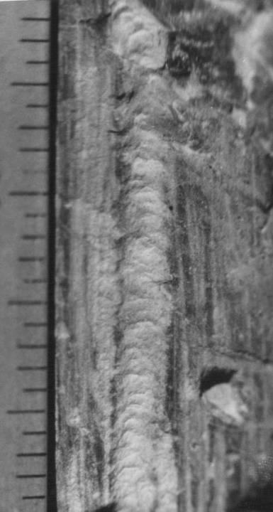
9 Chatter marks, arcuate cracks & lunate fractures

10 Lunate Fractures
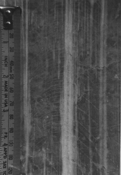
11 10 mm Striations up close


12 Laser profile of striation in stainless steel
13 Chatter marks, arcuate cracks & lunate fractures: Sliding indentors From B. Johnson dissertation, 1975 Rotating blocks

14 Glaciated Landscape with Cirques and Horns


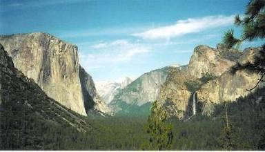
15 Yosemite Valley C 2 \ P U B L I C \ R o n \ B e r n a r d \

16 Speed in a Glacier Cross Section C.F. Raymond

17 Development of a U-Shaped Valley J. Harbor

18 Erosion into Strong Homogeneous Bedrock J. Harbor

19 Erosion into a Fault J. Harbor
20 Alaska: an ideal glacier laboratory Coastal mountains in Alaska's active margins offer an exceptional and largely untapped opportunity to measure and to understand rates of erosion from both glaciated and non-glaciated terrains rates are high (relief and precipitation are both high and bedrock is damaged) fjords are nearly perfect sediment traps for both suspended sediment and bedload. seismic profiles together with retreat history can be used to infer sediment yield history for ~100 years sediment sources are close to sinks and storage is minimal
21 Singular transition between major transform fault (Fairweather) & thrusting under most massive glaciers in N.America: coincidence?

22 Mt. St. Elias to Sea Level

23 Both transitions between major transform fault (Fairweather-Denali) & thrusting occur under most massive glaciers in N.America: coincidence?? Thrusting St. Elias? 5 cm/yr
 aneurysm (a la Koons & Zeilter)?")
24 Could rapid glacial erosion localize thrusting? a type of tectonic (crustal) aneurysm (a la Koons & Zeilter)? Or are glaciers just rapidly eroding fault-shattered rocks?

25 Extreme rates of erosion & uplift expected here? Malaspina Glacier

26 Massive sediment plumes reflect rapid sediment evacuation from coastal mountains to the Pacific

27 Holocene Sediment in Gulf of Alaska
28 Important to select glaciers carefully in assessing basin-wide erosion rates Requirements: - good sediment sink (fjords with sills that define deep basins, and proglacial lakes are ideal) -glacier must be in retreat otherwise they would be over-riding and entraining their own sediments; sediment yields would not reflect bedrock erosion (this is easy because, with few notable exceptions, all glaciers have been in retreat since the early 1900s, the end of the Little Ice Age) -Glacier must be fast moving and highly erosive to produce easily measured sediment volumes (seeking large signal-tonoise ratio)
29 But, this leads to systematic bias Glacial erosion rates from Alaskan tide-water glaciers are exceptionally large (cm s/yr) for the last century during rapid retreat, glacier surfaces were lowered 100 s of meters basin-wide. for tide-water glaciers in Alaska, most of the ice is lost by calving, not ablation, hence the drawdown results from greater ice loss by calving than is added as snow. This requires an acceleration of ice transfer to lower elevations. research at Columbia glacier shows that ice speeds increase with calving and retreat rates erosion rates are expected to increase with the more rapid basal ice motion during the retreat

30 Columbia Glacier, 2005
31 Calving glaciers: surprising relation between calving rate and ice speed U C = U i R U = kh C W Q = ku S i
32 Erosion History at Tyndall Glacier, Alaska From M. Koppes
33 Glacial & Non-Glacial Denudation Rates Rates from Alaskan Tide-water glacier reduced 5-fold Denudation rates Gl>10yrs/5 Glacial/ Himalaya B.C., Slaymaker Global, M&S, E+00 1E+01 1E+02 1E+03 1E+04 1E+05 1E+06 1E+07 Basin Area, km2
34 Alaska Glacier Erosion Are High but are they representative and robust? Peak rates of glacial erosion, inferred from sediment yields of tidewater glaciers, surpass those of fluvial erosion by up to an order of magnitude. They have recently come into question, however, because Biases inherent in the approach (effect of rapid retreat; sediments sloughing off fjord walls) Essentially nothing is known about characteristics of the glaciers or of the drainage basins that cause these high sediment yields. Little is known about whether peak erosion rates, found in southern Alaska, are representative of other glacial-tectonic settings.
35 Needs To improve our understanding of controls of erosion rates (sliding power, basal T) To determine erosion rates by dynamic glaciers outside Alaska: Patagonia To improve estimates of glacial erosion rates Longer time scales Better modeling of spatial and temporal patterns of erosion through the large glacialinterglacial climatic oscillations
36 Seek better understanding of how glacial erosion influences orogenic processes and reflects climate variability Need to identify controls on glacial erosion rates, as has been done for fluvial erosion for which precipitation rates and basin relief and size exert first-order controls. Similar quantitative relationships between glacial sediment yields and hydrologic or other basin characteristics have not yet been established. Peak rates of glacial erosion, inferred from sediment yields of tidewater glaciers, surpass those of fluvial erosion by up to an order of magnitude. They have recently come into question, however, because biases inherent in the approach essentially nothing is known about characteristics of the glaciers or of the drainage basins that cause these high sediment yields. Little know about whether peak erosion rates, found in southern Alaska, are representative of other glacial-tectonic settings.
37 From J. Tomkin Glacial Buzzsaw S.N. Thompson, 2004

38 Torres del Paine, Patagonia


39 Crossing Drake Passage Figure 5. Map of mean annual atmospheric isotherms, Antarctic Peninsula region Figure 6. Location DEM of Antarctic Peninsula study areas. Figure 7. Map of mean annual precipitation in Patagonia (mm/yr), HPN = Northern Patagonia Icefield, HPS = Southern Patagonia Icefield, CDW = Cordillera Darwin Icefield.
40 We propose to examine explicitly the role of glacier dynamics in determining glacial sediment yields through a combination of techniques from glaciology and marine geology. Hypothesis: rates of glacial erosion are a function of sliding speed, and are therefore expected to diminish sharply as basal temperatures drop below the melting point. To test this hypothesis, we will measure both sediment accumulation rates in fjords and dynamic characteristics of the glaciers producing the sediments, for six tidewater glaciers ranging from fast-moving temperate glaciers in Patagonia to slow-moving polar glaciers on the Antarctic Peninsula.
41 Patagonia & the Antarctic Peninsula: ideal natural laboratories for our purposes Large latitudinal range provides for a large range of precipitation and glacier thermal regimes over relatively homogeneous lithologies and tectonic settings Prior studies of the region have noted a significant decrease in glaciomarine sediment accumulation in the fjords along a southward transect but they have not assessed sediment yields or erosion rates, and Fjords constitute accessible and nearly perfect natural sediment traps that can be readily surveyed by research vessel, the Nathaniel Palmer.
42 For each glacier system, we aim to assess sediment yields and, by inference, erosion rates by determining sediment accumulation rates within the fjords using seismic profiles and core data measure dynamic properties and basin characteristics of each of the glaciers, which have distinctly different ice fluxes and basal thermal regimes. We will seek to define an empirical relationship between glacial erosion rates and ice dynamics.
What is a Glacier? Types of Glaciers
 Alpine & Continental Glaciers Glacial Mass Balance Glacial Ice Formation Glacial Movement & Erosion Erosional and Depositional Landforms The Pleistocene Epoch Geomorphology of SW Manitoba Chapter 17 1
Glacial Erosion: Processes, Rates & Landforms. Bernard Hallet ESS
 Glacial Erosion: Processes, Rates & Landforms Bernard Hallet ESS 685-2409 hallet@u.washington.edu Over the last decade the Earth Science community interested in glacial erosion has expanded and diversified
THE ACTION OF GLACIERS
 Surface processes THE ACTION OF GLACIERS Glaciers are enormous masses of ice which are formed due to accumulation, compaction and re-crystallisation of the snow deposited in very cold regions (the majority
Lecture 10 Glaciers and glaciation
 Lecture 10 Glaciers and glaciation Outline Importance of ice to people! Basics of glaciers formation, classification, mechanisms of movement Glacial landscapes erosion and deposition by glaciers and the
How do glaciers form?
 Glaciers What is a Glacier? A large mass of moving ice that exists year round is called a glacier. Glaciers are formed when snowfall exceeds snow melt year after year Snow and ice remain on the ground
Chapter 2. Wearing Down Landforms: Rivers and Ice. Physical Weathering
 Chapter 2 Wearing Down Landforms: Rivers and Ice Physical Weathering Weathering vs. Erosion Weathering is the breakdown of rock and minerals. Erosion is a two fold process that starts with 1) breakdown
1. Any process that causes rock to crack or break into pieces is called physical weathering. Initial product = final product
 Weathering 1. Any process that causes rock to crack or break into pieces is called physical weathering. Initial product = final product End Result of physical weathering is increased surface area. 2. Physical
Amazing Ice: Glaciers and Ice Ages
 Amazing Ice: Glaciers and Ice Ages Updated by: Rick Oches, Professor of Geology & Environmental Sciences Bentley University Waltham, Massachusetts Based on slides prepared by: Ronald L. Parker, Senior
Glaciers and Ice Ages
 ES 106 Glaciers and Ice Ages I. Glacier thick mass of ice accumulated over years, decades, centuries A. Function of recrystallization of fallen snow B. Types 1. alpine valley: a. high elevations worldwide
Spring break reading. Glacial formation. Surface processes: Glaciers and deserts. The Control of Nature
 suggested Spring break reading The Control of Nature by John McPhee Surface processes: Glaciers and deserts describes our efforts to control three natural hazards: 1. The Mississippi Floods 2. The Heimaey
Glaciers form wherever snow and ice can accumulate High latitudes High mountains at low latitudes Ice temperatures vary among glaciers Warm
 The Cryosphere Glaciers form wherever snow and ice can accumulate High latitudes High mountains at low latitudes Ice temperatures vary among glaciers Warm (temperate) glaciers: at pressure melting point,
Glaciers. (Shaping Earth s Surface, Part 6) Science 330 Summer 2005
 Science 330 Summer 2005") Glaciers (Shaping Earth s Surface, Part 6) Science 330 Summer 2005 1 Glaciers Glaciers are parts of two basic cycles Hydrologic cycle Rock cycle Glacier a thick mass of ice that originates on land from
Glaciers (Shaping Earth s Surface, Part 6) Science 330 Summer 2005 1 Glaciers Glaciers are parts of two basic cycles Hydrologic cycle Rock cycle Glacier a thick mass of ice that originates on land from
Glacial Modification of Terrain
 Glacial Modification Part I Stupendous glaciers and crystal snowflakes -- every form of animate or inanimate existence leaves its impress upon the soul of man. 1 -Orison Swett Marden Glacial Modification
Lecture Outlines PowerPoint. Chapter 6 Earth Science 11e Tarbuck/Lutgens
 Lecture Outlines PowerPoint Chapter 6 Earth Science 11e Tarbuck/Lutgens 2006 Pearson Prentice Hall This work is protected by United States copyright laws and is provided solely for the use of instructors
Glaciers Earth 9th Edition Chapter 18 Glaciers: summary in haiku form Key Concepts Glaciers Glaciers Glaciers Glaciers
 1 2 3 4 5 6 7 8 9 10 11 12 13 14 Earth 9 th Edition Chapter 18 : summary in haiku form Ten thousand years thence big glaciers began to melt - called "global warming." Key Concepts and types of glaciers.
PHYSICAL GEOGRAPHY. By Brett Lucas
 PHYSICAL GEOGRAPHY By Brett Lucas GLACIAL PROCESSES Glacial Processes The Impact of Glaciers on the Landscape Glaciations Past and Present Types of Glaciers Glacier Formation and Movement The Effects of
Foundations of Earth Science, 6e Lutgens, Tarbuck, & Tasa
 Foundations of Earth Science, 6e Lutgens, Tarbuck, & Tasa Glacial and Arid Landscapes Foundations, 6e - Chapter 4 Stan Hatfield Southwestern Illinois College Glaciers Glaciers are parts of two basic cycles
Glaciology (as opposed to Glacial Geology) Why important? What are glaciers? How do they work?
 Why important? What are glaciers? How do they work?") Glaciology (as opposed to Glacial Geology) Why important? What are glaciers? How do they work? Glaciers are important because of their role in creating glacial landscapes (erosional and depositional features).
Glaciology (as opposed to Glacial Geology) Why important? What are glaciers? How do they work? Glaciers are important because of their role in creating glacial landscapes (erosional and depositional features).
2/23/2009. Visualizing Earth Science. Chapter Overview. Deserts and Drylands. Glaciers and Ice Sheets
 Visualizing Earth Science By Z. Merali and B. F. Skinner Chapter 6 Deserts, Glaciers and Ice Sheets Chapter Overview Deserts and Drylands Glaciers and Ice Sheets Deserts Geography Categorization of deserts
Chapter 5: Glaciers and Deserts
 I. Glaciers and Glaciation Chapter 5: Glaciers and Deserts A. A thick mass of ice that forms over land from the compaction and recrystallization of snow and shows evidence of past or present flow B. Types
mountain rivers fixed channel boundaries (bedrock banks and bed) high transport capacity low storage input output
 high transport capacity low storage input output") mountain rivers fixed channel boundaries (bedrock banks and bed) high transport capacity low storage input output strong interaction between streams & hillslopes Sediment Budgets for Mountain Rivers Little
mountain rivers fixed channel boundaries (bedrock banks and bed) high transport capacity low storage input output strong interaction between streams & hillslopes Sediment Budgets for Mountain Rivers Little
Down-stream process transition (f (q s ) = 1)
 = 1)") Down-stream process transition (f (q s ) = 1) Detachment Limited S d >> S t Transport Limited Channel Gradient (m/m) 10-1 Stochastic Variation { Detachment Limited Equilibrium Slope S d = k sd A -θ d S
Down-stream process transition (f (q s ) = 1) Detachment Limited S d >> S t Transport Limited Channel Gradient (m/m) 10-1 Stochastic Variation { Detachment Limited Equilibrium Slope S d = k sd A -θ d S
Maximum Extent of Pleistocene Glaciation - 1/3 of land surface Most recent glacial maximum peaked 18,000 years ago and is considered to have ended
 Glaciers Maximum Extent of Pleistocene Glaciation - 1/3 of land surface Most recent glacial maximum peaked 18,000 years ago and is considered to have ended 10,000 B.P. Current Extent of Glaciation - about
Glacial processes and landforms NGEA01, 2014
 Glacial processes and landforms NGEA01, 2014 Cecilia Akselsson Department of Physical Geography and Ecosystem Science Lund University Geomorphological processes and landforms all over the world Periglacial
Mountain Rivers. Gutta cavat lapidem. (Dripping water hollows out a stone) -Ovid, Epistulae Ex Ponto, Book 3, no. 10, 1. 5
 -Ovid, Epistulae Ex Ponto, Book 3, no. 10, 1. 5") Mountain Rivers Gutta cavat lapidem (Dripping water hollows out a stone) -Ovid, Epistulae Ex Ponto, Book 3, no. 10, 1. 5 Mountain Rivers Fixed channel boundaries (bedrock banks and bed) High transport
Mountain Rivers Gutta cavat lapidem (Dripping water hollows out a stone) -Ovid, Epistulae Ex Ponto, Book 3, no. 10, 1. 5 Mountain Rivers Fixed channel boundaries (bedrock banks and bed) High transport
Lecture 21: Glaciers and Paleoclimate Read: Chapter 15 Homework due Thursday Nov. 12. What we ll learn today:! Learning Objectives (LO)
") Learning Objectives (LO) Lecture 21: Glaciers and Paleoclimate Read: Chapter 15 Homework due Thursday Nov. 12 What we ll learn today:! 1. 1. Glaciers and where they occur! 2. 2. Compare depositional and
Learning Objectives (LO) Lecture 21: Glaciers and Paleoclimate Read: Chapter 15 Homework due Thursday Nov. 12 What we ll learn today:! 1. 1. Glaciers and where they occur! 2. 2. Compare depositional and
1. What define planetary surfaces geologically? 2. What controls the evolution of planetary surfaces?
 Planetary Surfaces: 1. What define planetary surfaces geologically? 2. What controls the evolution of planetary surfaces? 3. How do surface-shaping processes scale across planetary bodies of different
Glacial Geomorphology Lecture 1: Glaciers & Glacial Environments. GGY 166: Geomorphology of Southern Africa
 Glacial Geomorphology Lecture 1: Glaciers & Glacial Environments GGY 166: Geomorphology of Southern Africa Relevance in Southern African Context South African landscape has been influenced by glacial action
The State of the cryosphere
 The State of the cryosphere Course outline Introduction The cryosphere; what is it? The Earth; a unique planet Cryospheric components Classifications Lecture outlines The State of the cryosphere The State
T. Perron Glaciers 1. Glaciers
 T. Perron 12.001 Glaciers 1 Glaciers I. Why study glaciers? [PPT: Perito Moreno glacier, Argentina] Role in freshwater budget o Fraction of earth s water that is fresh (non-saline): 3% o Fraction of earth
Mass Wasting and Landscape Evolution
 Mass Wasting and Landscape Evolution 11-8-06 Uplift is a tectonic process Three types of uplift: 1. Collisional uplift 2. isostatic uplift 3. Extensional uplif. A physical experiment in isostasy: [crust
INDEX_Glaciers.pdf. mountain (alpine) glacier NLG Test bank: [Glaciers01-03.jpg] High Quality: [Moraine_med-lat_Haines_AK_.jpg]
![INDEX_Glaciers.pdf. mountain (alpine) glacier NLG Test bank: [Glaciers01-03.jpg] High Quality: [Moraine_med-lat_Haines_AK_.jpg]](/thumbs/83/88580835.jpg "INDEX_Glaciers.pdf. mountain (alpine) glacier NLG Test bank: [Glaciers01-03.jpg] High Quality: [Moraine_med-lat_Haines_AK_.jpg]") Glaciers_INDEX.pdf This is an index of all terms/ideas in this question bank. Question banks are organized into topics containing related terms/ideas. Each term/idea has at least one related question,
Glaciers_INDEX.pdf This is an index of all terms/ideas in this question bank. Question banks are organized into topics containing related terms/ideas. Each term/idea has at least one related question,
Which landscape best represents the shape of the valleys occupied by glaciers? A) B) C) D)
 B) C) D)") 1. Glaciers often form parallel scratches and grooves in bedrock because glaciers A) deposit sediment in unsorted piles B) deposit rounded sand in V-shaped valleys C) continually melt and refreeze D) drag
1. Glaciers often form parallel scratches and grooves in bedrock because glaciers A) deposit sediment in unsorted piles B) deposit rounded sand in V-shaped valleys C) continually melt and refreeze D) drag
Physical Geography A Living Planet
 Physical Geography A Living Planet The geography and structure of the earth are continually being changed by internal forces, like plate tectonics, and external forces, like the weather. Iguaçu Falls at
Weathering Erosion and Deposition. Presented by Kesler Science
 Weathering Erosion and Deposition Presented by Kesler Science Essential Questions: 1. What effects do weathering, erosion, and deposition have on the environment in ecoregions? Weathering Chemical and
Periglacial Geomorphology
 Periglacial Geomorphology Periglacial Geomorphology Periglacial: literally means around glacial - term introduced in 1909 to describe landforms and processes around glaciated areas. Periglacial environments:
Match up the pictures and key terms
 Match up the pictures and key terms 1 Plucking Striations 3 Roche Mountonnees 2 Chatter Marks 4 What is the difference between plucking and abrasion? Glacial Processes Erosion, Weathering and Deposition
Extent of Periglacial = Global Permafrost Permafrost: Soil and/or rock where temperatures remain below 0 degrees C for 2 or more years.
 Geog 1000 - Lecture 34 Periglacial Environments and Paleoclimatology http://scholar.ulethbridge.ca/chasmer/classes/ Today s Lecture (Pgs 422-434) 1. Exam questions from last week, and today 2. Extent of
Prentice Hall EARTH SCIENCE
 Prentice Hall EARTH SCIENCE Tarbuck Lutgens Chapter 7 Glaciers, Desert, and Wind 7.1 Glaciers Types of Glaciers A glacier is a thick ice mass that forms above the snowline over hundreds or thousands of
Name. 4. The diagram below shows a soil profile formed in an area of granite bedrock. Four different soil horizons, A, B, C, and D, are shown.
 Name 1. In the cross section of the hill shown below, which rock units are probably most resistant to weathering? 4. The diagram below shows a soil profile formed in an area of granite bedrock. Four different
Glaciers: The Work of Ice
 CHAPTER 21 Glaciers: The Work of Ice Chapter Summary Glaciers form in cold and snow climates where snow accumulation exceeds the ablation of ice due to melting, sublimation, wind erosion, and iceberg calving.
STREAM SYSTEMS and FLOODS
 STREAM SYSTEMS and FLOODS The Hydrologic Cycle Precipitation Evaporation Infiltration Runoff Transpiration Earth s Water and the Hydrologic Cycle The Hydrologic Cycle The Hydrologic Cycle Oceans not filling
Precipitation Evaporation Infiltration Earth s Water and the Hydrologic Cycle. Runoff Transpiration
 STREAM SYSTEMS and FLOODS The Hydrologic Cycle Precipitation Evaporation Infiltration Earth s Water and the Hydrologic Cycle Runoff Transpiration The Hydrologic Cycle The Hydrologic Cycle Oceans not filling
Brita Horlings
 Knut Christianson Brita Horlings brita2@uw.edu https://courses.washington.edu/ess431/ Natural Occurrences of Ice: Distribution and environmental factors of seasonal snow, sea ice, glaciers and permafrost
Chapter 9 Notes: Ice and Glaciers, Wind and Deserts
 Chapter 9 Notes: Ice and Glaciers, Wind and Deserts *Glaciers and Glacial Features glacier is a mass of ice that moves over land under its own weight through the action of gravity Glacier Formation must
CORRELATION OF CLIMATIC AND SOLAR VARIATIONS OVER THE PAST 500 YEARS AND PREDICTING GLOBAL CLIMATE CHANGES FROM RECURRING CLIMATE CYCLES
 Easterbrook, D.J., 2008, Correlation of climatic and solar variations over the past 500 years and predicting global climate changes from recurring climate cycles: International Geological Congress, Oslo,
6. What has been the most effective erosive agent in the climate system? a. Water b. Ice c. Wind
 Multiple Choice. 1. Heinrich Events a. Show increased abundance of warm-water species of planktic foraminifera b. Show greater intensity since the last deglaciation c. Show increased accumulation of ice-rafted
Bell Ringer. Are soil and dirt the same material? In your explanation be sure to talk about plants.
 Bell Ringer Are soil and dirt the same material? In your explanation be sure to talk about plants. 5.3 Mass Movements Triggers of Mass Movements The transfer of rock and soil downslope due to gravity is
Weathering, Erosion, Deposition, and Landscape Development
 Weathering, Erosion, Deposition, and Landscape Development I. Weathering - the breakdown of rocks into smaller particles, also called sediments, by natural processes. Weathering is further divided into
Continental Landscapes
 Continental Landscapes Landscape influenced by tectonics, climate & differential weathering Most landforms developed within the last 2 million years System moves toward an equilibrium Continental Landscapes
Testing a glacial erosion rule using hang heights of hanging valleys, Jasper National Park, Alberta, Canada
 JOURNAL OF GEOPHYSICAL RESEARCH, VOL. 111,, doi:10.1029/2005jf000359, 2006 Testing a glacial erosion rule using hang heights of hanging valleys, Jasper National Park, Alberta, Canada J. M. Amundson 1 and
Guided Notes Surface Processes. Erosion & Deposition By: Glaciers
 Guided Notes Surface Processes Erosion & Deposition By: Glaciers K. Coder 2015 26) How does moving ice erode and deposit sediments? Glaciers (Movement of Ice): a naturally formed mass of ice and snow that
Social Studies. Chapter 2 Canada s Physical Landscape
 Social Studies Chapter 2 Canada s Physical Landscape Introduction Canada s geography its landforms and climate - has a great impact on Canadians sense of identity. Planet Earth The earth is divided into
Section 11.1 pp Where Mountains Form
 Section 11.1 pp. 236 237 Where Mountains Form Chapter 11 Set a Purpose: TE, p. 236 Reading Study Guide, p. 36 Discussion: TE, p. 236 Differentiating ion Reading Support: TE, p. 236 Visual Teaching Interpret
Neogene Uplift of The Barents Sea
 Neogene Uplift of The Barents Sea W. Fjeldskaar A. Amantov Tectonor/UiS, Stavanger, Norway FORCE seminar April 4, 2013 The project (2010-2012) Funding companies Flat Objective The objective of the work
UNRAVELING THE HISTORY OF A LANDSCAPE: Using geomorphology, tephrochronology, and stratigraphy. Photo by: Josh Roering
 UNRAVELING THE HISTORY OF A LANDSCAPE: Using geomorphology, tephrochronology, and stratigraphy Photo by: Josh Roering Photo: Eric Bilderback Photo by: Josh Roering Goal 1. Reconstruct the paleo-landscape
Post Little Ice Age Glacial Rebound in Glacier Bay National Park and Surrounding Areas
 36 Post Little Ice Age Glacial Rebound in Glacier Bay National Park and Surrounding Areas (Left and Above) Researchers Chris Larsen and Ellie Boyce set up GPS units over benchmarks set into bedrock at
Unit 1: Water Systems on Earth Chapter 2
 Unit 1: Water Systems on Earth Chapter 2 Create a mind map with the driving question, Why are Oceans Important? Remember: Why are oceans so important? Why are oceans so important? Primary water source
WHAT IS THE EARTH MADE OF? LITHOSPHERE AND HYDROSPHERE
 UNIT 8 WHAT IS THE EARTH MADE OF? LITHOSPHERE AND HYDROSPHERE TABLE OF CONTENTS 1 THE STRUCTURE OF THE EARTH... 2 2 THE FORMATION OF THE RELIEF: INTERNAL AND EXTERNAL FORCES.... 2 2.1 Internal forces:
RIVERS, GROUNDWATER, AND GLACIERS
 RIVERS, GROUNDWATER, AND GLACIERS Delta A fan-shaped deposit that forms when a river flows into a quiet or large body of water, such as a lake, an ocean, or an inland sea. Alluvial Fan A sloping triangle
Spatial distribution of glacial erosion rates in the St. Elias range, Alaska, inferred from a realistic model of glacier dynamics
 JOURNAL OF GEOPHYSICAL RESEARCH, VOL. 117,, doi:10.1029/2011jf002291, 2012 Spatial distribution of glacial erosion rates in the St. Elias range, Alaska, inferred from a realistic model of glacier dynamics
SVALBARD. Environmental changes in Svalbard since the last glacial maximum THE ROLE OF PERMAFROST
 SVALBARD Environmental changes in Svalbard since the last glacial maximum THE ROLE OF PERMAFROST Bernd Etzelmüller, Oslo, Norway With contribution by Hanne H. Christiansen, UNIS, Svalbard Discussion points
3/5/05 Dr. Stewart 1
 I. Physiography of Appalachian Mountains A. Introduction 1. These mountains extend from NE Canada to Georgia 2. They are the remains of a deeply eroded, ancient mountain chain once larger than the Himalayans
Synchronous acceleration of ice loss and glacial erosion, Glaciar Marinelli, Chilean Tierra del Fuego
 Journal of Glaciology, Vol. 55, No. 190, 2009 207 Synchronous acceleration of ice loss and glacial erosion, Glaciar Marinelli, Chilean Tierra del Fuego Michèle KOPPES, 1 Bernard HALLET, 2 John ANDERSON
Goals of Glacial Geomorphology Lectures
 Goals of Glacial Geomorphology Lectures 1. Answer question: How do glaciers modulate landscape development? 2. To introduce Earth s glacial history. 3. To discuss the formation and movement of different
Be able to understand the processes which occurred during the last ice age.
 Glaciation Learning Intentions Be able to understand the processes which occurred during the last ice age. Be able to describe and explain the formation of features formed during glacial periods. 1 Water
Chapter 15 Structures
 Chapter 15 Structures Plummer/McGeary/Carlson (c) The McGraw-Hill Companies, Inc. TECTONIC FORCES AT WORK Stress & Strain Stress Strain Compressive stress Shortening strain Tensional stress stretching
Landscape Development
 CHAPTER 22 Landscape Development Chapter Summary Landscapes are described in terms of their topography: elevation, the altitude of the surface of the Earth above sea level; relief, the difference between
Ch 10 Deposition Practice Questions
 1. Base your answer to the following question on the data table below. Six identical cylinders, A through F, were filled with equal volumes of sorted spherical particles. The data table shows the particle
Forces That Shape Earth. How do continents move? What forces can change rocks? How does plate motion affect the rock cycle?
 Forces That Shape Earth How do continents move? What forces can change rocks? How does plate motion affect the rock cycle? Plate Motion Mountain ranges are produced by plate tectonics. The theory of plate
4. The map below shows a meandering stream. Points A, B, C, and D represent locations along the stream bottom.
 1. Sediment is deposited as a river enters a lake because the A) velocity of the river decreases B) force of gravity decreases C) volume of water increases D) slope of the river increases 2. Which diagram
Goals of Glacial Geomorphology Lectures
 Goals of Glacial Geomorphology Lectures 1. Answer question: How do glaciers modulate landscape development? 2. To introduce Earth s glacial history. 3. To discuss the formation and movement of different
The elevations on the interior plateau generally vary between 300 and 650 meters with
 11 2. HYDROLOGICAL SETTING 2.1 Physical Features and Relief Labrador is bounded in the east by the Labrador Sea (Atlantic Ocean), in the west by the watershed divide, and in the south, for the most part,
How to Use This Presentation
 How to Use This Presentation To View the presentation as a slideshow with effects select View on the menu bar and click on Slide Show. To advance through the presentation, click the right-arrow key or
Glacier erosion and response to climate, from Alaska to Patagonia
 Glacier erosion and response to climate, from Alaska to Patagonia Michèle N. Koppes A dissertation submitted in partial fulfillment of the requirements for the degree of Doctor of Philosophy University
Name: Class: Date: Multiple Choice Identify the letter of the choice that best completes the statement or answers the question.
 Name: Class: Date: geology ch 7 test 2008 Multiple Choice Identify the letter of the choice that best completes the statement or answers the question. 1. Which of the following is true about ice sheets?
Glaciers. A glacier is a persistent mass of ice: snow accumulation exceeds melting. generally occur in two areas: high latitudes, or high elevations
 Page 1 of7 Glaciers A glacier is a persistent mass of ice: snow accumulation exceeds melting generally occur in two areas: high latitudes, or high elevations hence CONTINENTAL and ALPINE glaciation Glaciers
4. What type of glacier forms in a sloping valley between rock walls? a. firn glacier b. ice sheet c. cirque d. alpine glacier
 Multiple Choice Questions 1. The term means the loss of snow and ice by evaporation and melting. a. sublimation b. ablation c. erosion d. abrasion 2. What condition must be met for a glacier to begin flowing
GLOBAL WARMING: GLOBAL WARMING. landscape implications. Andrew Goudie St Cross College Oxford
 GLOBAL WARMING: GLOBAL WARMING landscape implications Andrew Goudie St Cross College Oxford THE PROCESS OF CHANGE HAS STARTED IPCC 2007 Increased Glacier retreat since the early 1990s Area of seasonally
Reading Material. See class website. Sediments, from Oceanography M.G. Gross, Prentice-Hall
 Reading Material See class website Sediments, from Oceanography M.G. Gross, Prentice-Hall Materials filling ocean basins Dissolved chemicals especially from rivers and mid-ocean ridges (volcanic eruptions)
Glacial Systems and Landscapes
 AQA Geography A-level Glacial Systems and Landscapes PMT Education Written by Jeevan Singh Glacial Systems and Landscapes Factors of Climate Change Glacial landscapes have a low level of resilience; they
Goals of Today s Lecture. Types of landscapes
 Goals of Today s Lecture 1. Breifly discuss mass continuity as applied to the landscape. 2. Establish the mechanisms that drive U (uplift rate) 3. Examine the linkages between the uplift of mountains,
Rapid evolution of a proglacial coastal lake
 Rapid evolution of a proglacial coastal lake 20 th and 21 th century changes in Jökulsárlón at Breiðamerkursandur, Vatnajökull, Iceland 1 Sverrir Guðmundsson 1 Helgi Björnsson 1 Finnur Pálsson 2 Etienne
Mass Movements, Wind, and Glaciers
 Mass Movements,, and Glaciers SECTION 8.1 Mass Movement at Earth s Surface In your textbook, read about mass movement. Use each of the terms below just once to complete the passage. avalanche creep landslide
Landscape. Review Note Cards
 Landscape Review Note Cards Last Ice Age Pleistocene Epoch that occurred about 22,000 Years ago Glacier A large, long lasting mass of ice which forms on land and moves downhill because of gravity. Continental
Glacier Hydrology. Why should you care?
 Glacier Hydrology Why should you care? Climate Local Meteorology Surface Mass And Energy Exchange Net Mass Balance Dynamic Response Effect on Landscape Changes In Geometry Water Flow PRACTICAL MATTERS:
Topic 6: Weathering, Erosion and Erosional-Deposition Systems (workbook p ) Workbook Chapter 4, 5 WEATHERING
 Workbook Chapter 4, 5 WEATHERING") Topic 6: Weathering, Erosion and Erosional-Deposition Systems (workbook p. 95-125) Workbook Chapter 4, 5 THE BIG PICTURE: Weathering, erosion and deposition are processes that cause changes to rock material
Topic 6: Weathering, Erosion and Erosional-Deposition Systems (workbook p. 95-125) Workbook Chapter 4, 5 THE BIG PICTURE: Weathering, erosion and deposition are processes that cause changes to rock material
Areal Scour vs. Selective Linear Erosion
 Erosional Forms and Landscapes Erosional Landscapes Areal Scour vs. Selective Linear Erosion Cirques Form and Morphology Many Forms Red Tarn Cirque Basin English Lake District Red Tarn Cirque Basin, English
Landscape evolution. An Anthropic landscape is the landscape modified by humans for their activities and life
 Landforms Landscape evolution A Natural landscape is the original landscape that exists before it is acted upon by human culture. An Anthropic landscape is the landscape modified by humans for their activities
Permafrost-influenced Geomorphic Processes
 Section 4 Permafrost-influenced Geomorphic Processes Geomorphic processes vary greatly among ecoregions in northern Alaska, extending from the Beaufort Sea coast to the Brooks Range (Figure 4.1). Regional
Goals of Glacial Geomorphology Lectures
 Goals of Glacial Geomorphology Lectures 1. Answer question: How do glaciers modulate landscape development? 2. To introduce Earth s glacial history. 3. To discuss the formation and movement of different
Topic 2: Landscape Systems, Processes and Change
 Topic 2: Landscape Systems, Processes and Change Option 2A: Glaciated Landscapes and Change Overview Ice sheets and glaciers operate within a landscape system as glacial processes of erosion, transport
Goals of Glacial Geomorphology Lectures
 Goals of Glacial Geomorphology Lectures 1. Answer question: How do glaciers modulate landscape development? 2. To introduce Earth s glacial history. 3. To discuss the formation and movement of different
Section 2.1 Ocean Basins. - Has helped determine where ocean basins are located. - Tectonic plates move changing the position of the continents.
 Science 8 Unit 1: Water Systems on Earth Chapter 2: Oceans Control the Water Cycle Section 2.1 Ocean Basins Oceans are important because: 1. Primary water source for the water cycle 2. Control weather
Setting the Stage 8/28/09 1. Review. Landscape history of WY. Climate, geology and vegetation patterns in Wyoming
 Setting the Stage Climate, geology and vegetation patterns in Wyoming 8/28/09 1 Review Vegetation ecology has its roots in phytogeography: Observation and description of PATTERNS of plant species distributions
Page 1. Weathering & Erosion by Mass Wasting Pre-Test. Name:
 Weathering & Erosion by Mass Wasting Pre-Test 3048-1 - Page 1 Name: 1) As a particle of sediment in a stream breaks into several smaller pieces, the rate of weathering of the sediment will A) increase
Geomorphology for Engineers
 Geomorphology for Engineers Edited by P. G. Fookes, E. M. Lee and G. Milligan Whittles Publishing CRC PRESS Contents Foreword Preface Dedication Biographies 1. Introduction to Engineering Geomorphology
12. The diagram below shows the collision of an oceanic plate and a continental plate.
 Review 1. Base your answer to the following question on the cross section below, which shows the boundary between two lithospheric plates. Point X is a location in the continental lithosphere. The depth
PALEOGEOGRAPHY of NYS. Definitions GEOLOGIC PROCESSES. Faulting. Folding 9/6/2012. TOPOGRAPHIC RELIEF MAP of NYS GRADATIONAL TECTONIC
 TOPOGRAPHIC RELIEF MAP of NYS PALEOGEOGRAPHY of NYS Prof. Anthony Grande AFG 2012 Definitions GEOLOGIC PROCESSES Geography: study of people living on the surface of the earth. Geology: the scientific study
Questions and Topics
 Plate Tectonics and Continental Drift Questions and Topics 1. What are the theories of Plate Tectonics and Continental Drift? 2. What is the evidence that Continents move? 3. What are the forces that