UNRAVELING THE HISTORY OF A LANDSCAPE: Using geomorphology, tephrochronology, and stratigraphy. Photo by: Josh Roering
|
|
|
- Cameron Bates
- 5 years ago
- Views:
Transcription

1 UNRAVELING THE HISTORY OF A LANDSCAPE: Using geomorphology, tephrochronology, and stratigraphy Photo by: Josh Roering

2 Photo: Eric Bilderback

3 Photo by: Josh Roering Goal 1. Reconstruct the paleo-landscape 2. Confirm with the offshore sedimentary record
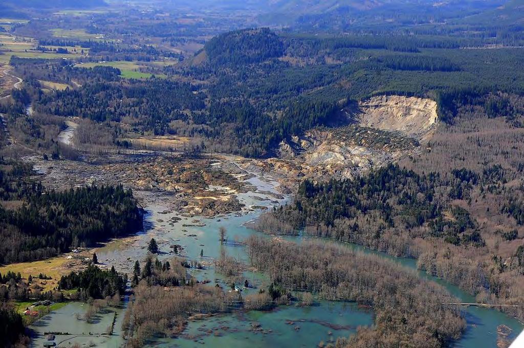
 Evidence of widespread earthflows")
4 Why Waipaoa? Transient landscape Hillslope are currently adjusting to rapid channel incision post- Last Glacial Maximum (LGM) Evidence of widespread earthflows Understand how landscape responds to perturbations on short and long timescales (Roering Lab s bread and butter) Crosby & Whipple (2006)
5 Motivation
 changes to")
6 Waipaoa River Sedimentary System End of the Last Glacial Maximum (LGM) in the Waipaoa -approx. 18 ka -major shift in climate, vegetation, and fluvial processes Major pulse of rapid incision Recent (historical) changes to the system Photo: David Schmidt


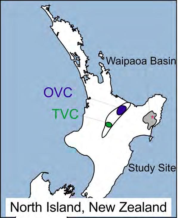
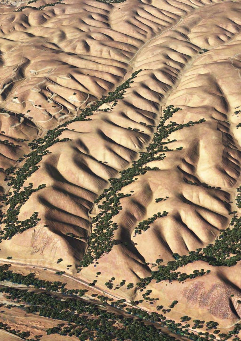
7 Study Area Mangataikapua Catchment


8 Study Area Mangataikapua Catchment Mangataikapua Stream 15 km 2 sub-catchment of the Waipaoa River Periglacial environment Podocarp forest post- LGM Mostly converted to pastureland in early 20 th century Weak mélange of marine sedimentary rocks in sheared smectitic mudstone matrix Uplift rates: ~1mm/yr Incision rates: ~4mm/yr
 Corina looks at erosion from landslides Method: 1)")
 Compare to sediments (for Becky) Marden et")
9 Approximating Sediment Eroded Previous Studies ignored hillslopes (Corina s $$ maker hopefully) Corina looks at erosion from landslides Method: 1) Date landforms 2) LGM landscape Reconstruction 3) Approximate volume change between LGM and now 4) Compare to sediments (for Becky) Marden et al. (2008)

10 Tephra Record Photo/Figure: Eric Bilderback
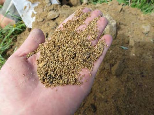
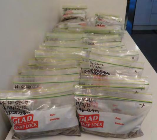
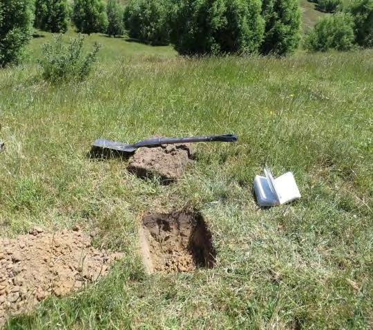
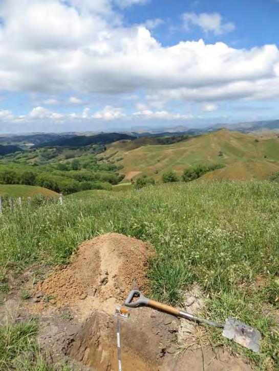
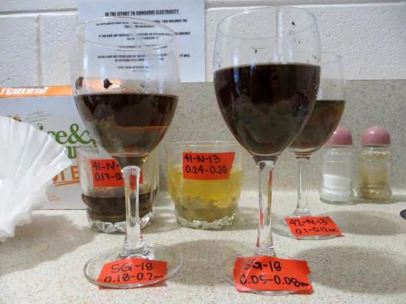
11 Sample Collection Collect basal tephra Analyze glass composition Compared to known tephras
 Waimihia (3.4 ka) Whakatane (5.")
 Rerewhakaaitu (17.6 ka) Omataroa (32.")

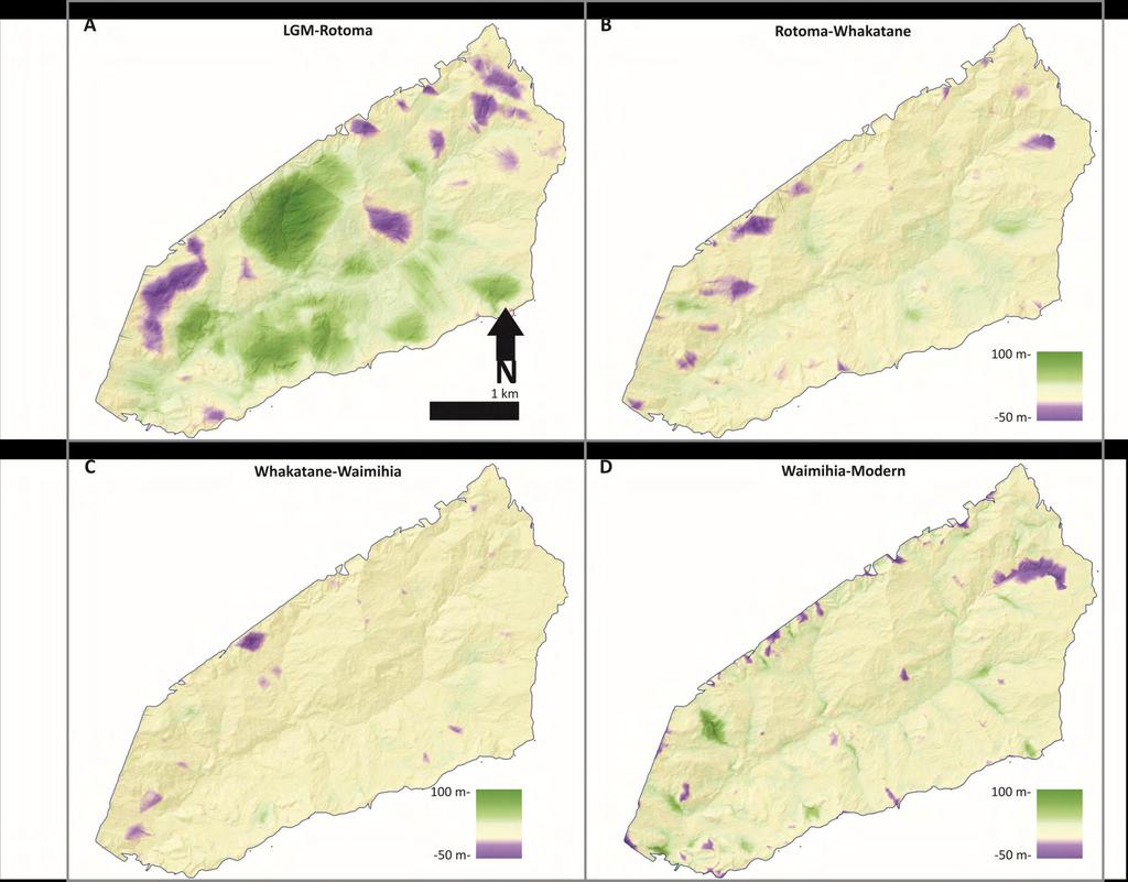
12 Tephrochronology No Tephra Unknown Taupo (1.7 ka) Waimihia (3.4 ka) Whakatane (5.5 ka Rotoma (9.5 ka) Opepe (10.1 ka) Rerewhakaaitu (17.6 ka) Omataroa (32.5 ka) A1 EMPA Analyzed Sample Sample Collected No Sample Collected N 500 m <5% of this catchment is relict (LGM) terrain!
13 Reconstruction

14 Landscape Roughness


15 Landscape Roughness Correlate age to roughness Gives estimated age for every point in landscape


16 Reconstruction Connect the dots of like age Use ridgelines and paleochannel elevations Reconstruct past hillslope configuration through time Use to calculate sediment flux
17
18 Erosion Rates from Reconstructions
19 Schematic of Hillslope Response Initially gravel filled valley buttresses slopes LGM (pre-rerewhakaaitu)
20 Schematic of Hillslope Response Initially gravel filled valley buttresses slopes Post-LGM river removes gravel and begins incising into bedrock Rerewhakaaitu (17.6 ka)-rotoma (9.5 ka)
21 Schematic of Hillslope Response Initially gravel filled valley buttresses slopes Post-LGM river removes gravel and begins incising into bedrock Slopes destabilized and fail as large block/rotational landslides Rotoma (9.5 ka)-waimihia/whakatane (4 ka)
22 Schematic of Hillslope Response Initially gravel filled valley buttresses slopes Post-LGM river removes gravel and begins incising into bedrock Slopes destabilized and fail as large block/rotational landslides Deposits mobilized as earthflows Waimihia/Whakatane (4 ka)-deforestation (0.1 ka)
23 Schematic of Hillslope Response Initially gravel filled valley buttresses slopes Post-LGM river removes gravel and begins incising into bedrock Slopes destabilized and fail as large block/rotational landslides Deposits mobilized as earthflows Earthflows re-initiate following deforestation Deforestation (0.1 ka)-present

24 Verifying My Story Use other proxies 1. Offshore sediment records 2. Offshore carbon-14 records Assumptions 1. Closed basin 2. Limited storage in floodplains 3. Same sediment Questions: What signature do landslides leave in the depositional record? What would we expect to see preserved offshore?
25 Offshore Story Brown, L., Holocene shoreline depositional processes at Poverty Bay, a tectonically active area, northeastern North Island, New Zealand. Quat. Int. 26,


26 Offshore Story Grain size shifts Marden et al. (2008)
27 More grain size Leithold et al., Signals of watershed change preserved in organic carbon buried on the continental margin seaward of the Waipaoa River, New Zealand. Mar. Geol. 346,
28 Offshore Story Where is older carbon? What is source of older, recycled, carbon? Carbon signature Leithold et al., Signals of watershed change preserved in organic carbon buried on the continental margin seaward of the Waipaoa River, New Zealand. Mar. Geol. 346,
29 Comparison of Offshore and Onshore Hillslopes responded to channel incision ~10ka (lagged behind) See gravels offshore General decrease landsliding until ~3 ka See decrease in grain size Large, deep landslides occasionally See older, recycled wood

30 Take-Home Points 1. Accurately estimated paleo-landscape Geomorphologic story (quantified with tephra) 2. Completed source-to-sink story Assuming a closed system with limited storage 3. Used offshore stratigraphy to verify onshore geomorphology Offshore sediment records (grain size variation & gravel deposits) and carbon records (wood ages/sources)
mountain rivers fixed channel boundaries (bedrock banks and bed) high transport capacity low storage input output
 high transport capacity low storage input output") mountain rivers fixed channel boundaries (bedrock banks and bed) high transport capacity low storage input output strong interaction between streams & hillslopes Sediment Budgets for Mountain Rivers Little
mountain rivers fixed channel boundaries (bedrock banks and bed) high transport capacity low storage input output strong interaction between streams & hillslopes Sediment Budgets for Mountain Rivers Little
GLG362/GLG598 Geomorphology K. Whipple October, 2009 I. Characteristics of Alluvial Channels
 I. Characteristics of Alluvial Channels Self-formed morphology set by entrainment, transport, and deposition They move unconsolidated sedimentary materials present in the valley fill flood plain/bank flow
DATA REPOSITORY MATERIAL: PALEOCHANNEL GROUP MAPPING DESCRIPTIONS
 Data Repository item 2695 DATA REPOSITORY MATERIAL: PALEOCHANNEL GROUP MAPPING DESCRIPTIONS Groups 1 (North Myrtle Beach) and 2 (Atlantic Beach) Channel Groups 1 (North Myrtle Beach) and 2 (Atlantic Beach)
Ch 10 Deposition Practice Questions
 1. Base your answer to the following question on the data table below. Six identical cylinders, A through F, were filled with equal volumes of sorted spherical particles. The data table shows the particle
Source- to- Sink in the Stra/graphic Record
 Source- to- Sink in the Stra/graphic Record Capturing the Long-Term, Deep-Time Evolution of Sedimentary Systems Stephan A. Graham Stanford University Brian W. Romans Chevron Energy Technology Co. Jacob
Drainage Basin Geomorphology. Nick Odoni s Slope Profile Model
 Drainage Basin Geomorphology Nick Odoni s Slope Profile Model Odoni s Slope Profile Model This model is based on solving the mass balance (sediment budget) equation for a hillslope profile This is achieved
Sediments and bedrock erosion
 Eroding landscapes: fluvial processes Sediments and bedrock erosion Mikaël ATTAL Marsyandi valley, Himalayas, Nepal Acknowledgements: Jérôme Lavé, Peter van der Beek and other scientists from LGCA (Grenoble)
Determination of uplift rates of fluvial terraces across the Siwaliks Hills, Himalayas of central Nepal
 Determination of uplift rates of fluvial terraces across the Siwaliks Hills, Himalayas of central Nepal Martina Böhme Institute of Geology, University of Mining and Technology, Freiberg, Germany Abstract.
Lab Final Review 4/16/18
 Lab Final Review 4/16/18 Overall goals from lab Think about geology on recent timescales, predict the direction change Be able to identify how different landforms or patterns (e.g. drainage patterns, dune
Legacy Sediment in the Piedmont: Past valley aggradation, modern stream erosion, and implications for stream water quality
 Funding provided by grants from: NC WRRI (Grant # 2010-70254), Geological Society of America, Sigma Xi, and NCSU Undergrad Research funds Legacy Sediment in the Piedmont: Past valley aggradation, modern
Topographic metrics and bedrock channels Outline of this lecture
 Topographic metrics and bedrock channels Outline of this lecture Topographic metrics Fluvial scaling and slope-area relationships Channel steepness sensitivity to rock uplift Advancing understanding of
GSA DATA REPOSITORY Sternai et al. 1. Algorithm Flow Chart
 GSA DATA REPOSITORY 2012311 Sternai et al. 1. Algorithm Flow Chart Figure DR1: Flow chart of the algorithm to further clarify the calculation scheme. 2. Reconstruction of the Pre-Glacial Alpine Topography
Mountain Rivers. Gutta cavat lapidem. (Dripping water hollows out a stone) -Ovid, Epistulae Ex Ponto, Book 3, no. 10, 1. 5
 -Ovid, Epistulae Ex Ponto, Book 3, no. 10, 1. 5") Mountain Rivers Gutta cavat lapidem (Dripping water hollows out a stone) -Ovid, Epistulae Ex Ponto, Book 3, no. 10, 1. 5 Mountain Rivers Fixed channel boundaries (bedrock banks and bed) High transport
Mountain Rivers Gutta cavat lapidem (Dripping water hollows out a stone) -Ovid, Epistulae Ex Ponto, Book 3, no. 10, 1. 5 Mountain Rivers Fixed channel boundaries (bedrock banks and bed) High transport
2.2.7 Backbarrier flats
 FIGURE 24. VERTICAL PHOTOGRAPH SHOWING THE DEVELOPMENT OF SMALL PARABOLIC DUNES FROM BLOWOUTS IN A LARGE RELICT FOREDUNE NORTHWEST OF HUNTER'S CREEK. PHOTOGRAPH COURTESY OF CAR'T'ER HOLT HARVEY FORESTS
Landscape Development
 Landscape Development Slopes Dominate Natural Landscapes Created by the interplay of tectonic and igneous activity and gradation Deformation and uplift Volcanic activity Agents of gradation Mass wasting
NATURE OF RIVERS B-1. Channel Function... ALLUVIAL FEATURES. ... to successfully carry sediment and water from the watershed. ...dissipate energy.
 1 2 Function... Sevier River... to successfully carry sediment and water from the watershed....dissipate energy. 3 ALLUVIAL FEATURES 4 CHANNEL DIMENSION The purpose of a stream is to carry water and sediment
Down-stream process transition (f (q s ) = 1)
 = 1)") Down-stream process transition (f (q s ) = 1) Detachment Limited S d >> S t Transport Limited Channel Gradient (m/m) 10-1 Stochastic Variation { Detachment Limited Equilibrium Slope S d = k sd A -θ d S
Down-stream process transition (f (q s ) = 1) Detachment Limited S d >> S t Transport Limited Channel Gradient (m/m) 10-1 Stochastic Variation { Detachment Limited Equilibrium Slope S d = k sd A -θ d S
Formation of Fluvial Hanging Valleys: Theory and Simulation
 Formation of Fluvial Hanging Valleys: Theory and Simulation Benjamin T. Crosby 1,2 Kelin X Whipple 1 Nicole M. Gasparini 3 Cameron W. Wobus 1,4 1 Department of Earth, Atmospheric and Planetary Sciences,
Offshore Evidence for Uplift Rate Boundaries. Hans AbramsonWard Diablo Canyon SSHAC SSC Workshop 2 November 7, 2012
 Offshore Evidence for Uplift Rate Boundaries Hans AbramsonWard Diablo Canyon SSHAC SSC Workshop 2 November 7, 2012 Questions asked by the TI team Discuss your ability to distinguish and correlate offshore
Accommodation. Tectonics (local to regional) Subsidence Uplift
 Subsidence Uplift") Accommodation Accommodation varies over time; it is the distance between a reference horizon and the sea surface (i.e. relative sea level). The space to be filled in with sediments or water What are the
Accommodation Accommodation varies over time; it is the distance between a reference horizon and the sea surface (i.e. relative sea level). The space to be filled in with sediments or water What are the
depression above scarp scarp
 1 LAB 1: FIELD TRIP TO McKINLEYVILLE AND MOUTH OF THE MAD RIVER OBJECTIVES: a. to look at geomorphic and geologic evidence for large scale thrust-faulting of young sediments in the Humboldt Bay region
A MULTI-CRITERIA APPROACH SUPPORTING THE INVESTIGATION OF A FLOODPLAIN POTENTIALLY CONTAMINATED BY PESTICIDES
 A MULTI-CRITERIA APPROACH SUPPORTING THE INVESTIGATION OF A FLOODPLAIN POTENTIALLY CONTAMINATED BY PESTICIDES L ZILIANI, B GROPPELLI, S CECCON, F COLOMBO (RAMBOLL ENVIRON) D BOCCHIOLA, M C RULLI, G RAVAZZANI,
UNIT 4: Earth Science Chapter 21: Earth s Changing Surface (pages )
") CORNELL NOTES Directions: You must create a minimum of 5 questions in this column per page (average). Use these to study your notes and prepare for tests and quizzes. Notes will be turned in to your teacher
CORNELL NOTES Directions: You must create a minimum of 5 questions in this column per page (average). Use these to study your notes and prepare for tests and quizzes. Notes will be turned in to your teacher
EARTH SURFACE PROCESSES AND SEDIMENTATION!
 Sed and Strat EARTH SURFACE PROCESSES AND SEDIMENTATION! 2/27 Lecture 7- Exposure: Weathering and the Sediment Factory 3/04 Lecture 8 - Rivers and Landscapes 3/06 Lecture 9 - Waves (not Tides) 3/11 Lecture
Sediment and sedimentary rocks Sediment
 Sediment and sedimentary rocks Sediment From sediments to sedimentary rocks (transportation, deposition, preservation and lithification) Types of sedimentary rocks (clastic, chemical and organic) Sedimentary
Landscape. Review Note Cards
 Landscape Review Note Cards Last Ice Age Pleistocene Epoch that occurred about 22,000 Years ago Glacier A large, long lasting mass of ice which forms on land and moves downhill because of gravity. Continental
10/27/2014. Surface Processes. Surface Processes. Surface Processes. Surface Processes. Surface Processes
 Hewitt/Lyons/Suchocki/Yeh Conceptual Integrated Science Chapter 25 Surface or surficial processes originate at Earth's surface and reshape its contours. Surface processes include: Weathering Erosion Deposition
Lab 7: Sedimentary Structures
 Name: Lab 7: Sedimentary Structures Sedimentary rocks account for a negligibly small fraction of Earth s mass, yet they are commonly encountered because the processes that form them are ubiquitous in the
MISSISSIPPI RIVER DELTA OVERVIEW
 MISSISSIPPI RIVER DELTA OVERVIEW Science and Engineering Special Team Conference Louisiana State University October 9, 2012 Introduction Basics of the Mississippi Delta Natural and Human-Induced Land Loss
Diagnostic Geomorphic Methods for Understanding Future Behavior of Lake Superior Streams What Have We Learned in Two Decades?
 Diagnostic Geomorphic Methods for Understanding Future Behavior of Lake Superior Streams What Have We Learned in Two Decades? Faith Fitzpatrick USGS WI Water Science Center, Middleton, WI fafitzpa@usgs.gov
TE AWAROA: RESTORING 1000 RIVERS RESEARCH REPORT 1: WAIMATA RIVER CAROLA CULLUM, GARY BRIERLEY, MIKE MARDEN
 TE AWAROA: RESTORING 1000 RIVERS RESEARCH REPORT 1: WAIMATA RIVER CAROLA CULLUM, GARY BRIERLEY, MIKE MARDEN LANDSCAPES & RIVERS OF THE WAIMATA AND TARUHERU, 2017 Landscapes and Rivers of the Waimatā and
The River Restoration Centre therrc.co.uk. Understanding Fluvial Processes: supporting River Restoration. Dr Jenny Mant
 The River Restoration Centre therrc.co.uk Understanding Fluvial Processes: supporting River Restoration Dr Jenny Mant Jenny@therrc.co.uk Understanding your catchment Hydrology Energy associated with the
Edinburgh Research Explorer
 Edinburgh Research Explorer GEOMORPHOLOGY Rivers split as mountains grow Citation for published version: Attal, M 2009, 'GEOMORPHOLOGY Rivers split as mountains grow' Nature Geoscience, vol. 2, no. 11,
Annotated Bibliography of River Avulsions Pat Dryer Geography 364 5/14/2007
 Annotated Bibliography of River Avulsions Pat Dryer Geography 364 5/14/2007 1 Table of Contents Introduction 2 Annotations I. River avulsions and their deposits 2 II. Channel avulsion on alluvial fans
Sedimentary Rocks. Origin, Properties and Identification. Geology Laboratory GEOL 101 Lab Ray Rector - Instructor
 Sedimentary Rocks Origin, Properties and Identification Geology Laboratory GEOL 101 Lab Ray Rector - Instructor Sedimentary Rock Origin and Identification Lab Pre-Lab Internet Link Resources 1) http://www.rockhounds.com/rockshop/rockkey/index.html
1. What define planetary surfaces geologically? 2. What controls the evolution of planetary surfaces?
 Planetary Surfaces: 1. What define planetary surfaces geologically? 2. What controls the evolution of planetary surfaces? 3. How do surface-shaping processes scale across planetary bodies of different
The Geology of Sebago Lake State Park
 Maine Geologic Facts and Localities September, 2002 43 55 17.46 N, 70 34 13.07 W Text by Robert Johnston, Department of Agriculture, Conservation & Forestry 1 Map by Robert Johnston Introduction Sebago
Lecture 10 Glaciers and glaciation
 Lecture 10 Glaciers and glaciation Outline Importance of ice to people! Basics of glaciers formation, classification, mechanisms of movement Glacial landscapes erosion and deposition by glaciers and the
Lecture Outline Wednesday - Friday February 14-16, 2018
 Lecture Outline Wednesday - Friday February 14-16, 2018 Quiz 2 scheduled for Friday Feb 23 (Interlude B, Chapters 6,7) Questions? Chapter 6 Pages of the Past: Sedimentary Rocks Key Points for today Be
River Response. Sediment Water Wood. Confinement. Bank material. Channel morphology. Valley slope. Riparian vegetation.
 River Response River Response Sediment Water Wood Confinement Valley slope Channel morphology Bank material Flow obstructions Riparian vegetation climate catchment vegetation hydrological regime channel
Geomorphology Geology 450/750 Spring Fluvial Processes Project Analysis of Redwood Creek Field Data Due Wednesday, May 26
 Geomorphology Geology 450/750 Spring 2004 Fluvial Processes Project Analysis of Redwood Creek Field Data Due Wednesday, May 26 This exercise is intended to give you experience using field data you collected
Name. 4. The diagram below shows a soil profile formed in an area of granite bedrock. Four different soil horizons, A, B, C, and D, are shown.
 Name 1. In the cross section of the hill shown below, which rock units are probably most resistant to weathering? 4. The diagram below shows a soil profile formed in an area of granite bedrock. Four different
Cattaraugus Creek: A Story of Flowing Water and the Geology of the Channel It Flows Through Presentation to West Valley Citizen Task Force 4/27/16
 Cattaraugus Creek: A Story of Flowing Water and the Geology of the Channel It Flows Through Presentation to West Valley Citizen Task Force 4/27/16 Raymond C. Vaughan, Ph.D. What happens if you drop a
ENVIRONMENTAL GEOSCIENCE UNIFORM SYLLABUS
 ENVIRONMENTAL GEOSCIENCE UNIFORM SYLLABUS The Association of Professional Engineers and Geoscientists of the Province of British Columbia Note: 1. This Syllabus May Be Subject To Change 2. These Courses
Sequence Stratigraphy. Historical Perspective
 Sequence Stratigraphy Historical Perspective Sequence Stratigraphy Sequence Stratigraphy is the subdivision of sedimentary basin fills into genetic packages bounded by unconformities and their correlative
DR-1, DR-2, DR-3, DR-4, DR-5, DR-6
 GSA Data Repository item 2007216 The influence of large landslides on river incision in a transient landscape: Eastern margin of the Tibetan Plateau (Sichuan, China) William B. Ouimet GSA Bulletin; doi:
Importance of Understanding Coastal Landforms
 Importance of Understanding Coastal Landforms Costa Concordia Shipwreck, Isola del Giglio, Italy Depositional Coastal Landforms Can interpret landforms in light of geomorphic processes, both terrestrial
Why Geomorphology for Fish Passage
 Channel Morphology - Stream Crossing Interactions An Overview Michael Love Michael Love & Associates mlove@h2odesigns.com (707) 476-8938 Why Geomorphology for Fish Passage 1. Understand the Scale of the
Earth Systems Science Chapter 7. Earth Systems Science Chapter 7 11/11/2010. Seismology: study of earthquakes and related phenomena
 Earth Systems Science Chapter 7 I. Structure of the Earth II. Plate Tectonics The solid part of the earth system includes processes, just like the atmosphere and oceans. However, the time scales for processes
Stratigraphic modelling using CHILD
 5 Stratigraphic modelling using CHILD 5.1 Triangular irregular network Surface process models are widely used in geomorphology and geology, and the developments in the field follow each other rapidly.
The Effects of Hydraulic Structures on Streams Prone to Bank Erosion in an Intense Flood Event: A Case Study from Eastern Hokkaido
 Symposium Proceedings of the INTERPRAENENT 2018 in the Pacific Rim The Effects of Hydraulic Structures on Streams Prone to Bank Erosion in an Intense Flood Event: A Case Study from Eastern Hokkaido Daisuke
STUDY GUIDE FOR CONTENT MASTERY. Surface Water Movement
 Surface Water SECTION 9.1 Surface Water Movement In your textbook, read about surface water and the way in which it moves sediment. Complete each statement. 1. An excessive amount of water flowing downslope
FLUVIAL PROCESSES 13 MARCH 2014
 FLUVIAL PROCESSES 13 MARCH 2014 In this lesson we: Lesson Description Look at river profiles, river grading, river rejuvenation as well as the identification, description and formation of fluvial landforms.
Lecture 1: Scope, assessment and structure of course; Introduction to Sedimentology and Basic Definitions: uses and applications of Sedimentology.
 GEOL 440 Sedimentology and stratigraphy: processes, environments and deposits Jim Best MWF: Lectures and F: Laboratory Class Bruce Fouke Lecture 1: Scope, assessment and structure of course; Introduction
STREAM SYSTEMS and FLOODS
 STREAM SYSTEMS and FLOODS The Hydrologic Cycle Precipitation Evaporation Infiltration Runoff Transpiration Earth s Water and the Hydrologic Cycle The Hydrologic Cycle The Hydrologic Cycle Oceans not filling
Precipitation Evaporation Infiltration Earth s Water and the Hydrologic Cycle. Runoff Transpiration
 STREAM SYSTEMS and FLOODS The Hydrologic Cycle Precipitation Evaporation Infiltration Earth s Water and the Hydrologic Cycle Runoff Transpiration The Hydrologic Cycle The Hydrologic Cycle Oceans not filling
Geomorphology for Engineers
 Geomorphology for Engineers Edited by P. G. Fookes, E. M. Lee and G. Milligan Whittles Publishing CRC PRESS Contents Foreword Preface Dedication Biographies 1. Introduction to Engineering Geomorphology
Rivers T. Perron
 1 Rivers T. Perron 12.001 After our discussions of large-scale topography, how we represent topography in maps, and how topography interacts with geologic structures, you should be frothing at the mouth
GEOL151 Fall 2016: Lab for Week #9 Glacial Erosion, Sediment Transport, and Deposition in the Champlain Valley
 GEOL151 Fall 2016: Lab for Week #9 Glacial Erosion, Sediment Transport, and Deposition in the Champlain Valley Overview This week, we will delve into glacial processes and landforms. Glaciers are generally
Name: Period: Date: ID: A. Circle the choice that best completes the statement or answers the question and write the letter on the blank.
 Name: Period: _ Date: _ ID: A Unit 7 Practice Circle the choice that best completes the statement or answers the question and write the letter on the blank. 1. What term describes the movement of rock
core mantle crust the center of the Earth the middle layer of the Earth made up of molten (melted) rock
 rock") core the center of the Earth mantle the middle layer of the Earth made up of molten (melted) rock crust the surface layer of the Earth that includes the continents and oceans 1 continental drift the theory
core the center of the Earth mantle the middle layer of the Earth made up of molten (melted) rock crust the surface layer of the Earth that includes the continents and oceans 1 continental drift the theory
Glacial Erosion II: Processes, Rates & Landforms. Bernard Hallet ESS
 Glacial Erosion II: Processes, Rates & Landforms Bernard Hallet ESS 685-2409 hallet@u.washington.edu Housekeeping for the day Friday Discussion Section Holiday Friday no discussion session Monday Discussion
Journal of Earth Sciences and Geotechnical Engineering, vol. 4, no. 1, 2014, ISSN: (print), (online) Scienpress Ltd, 2014
, (online) Scienpress Ltd, 2014") Journal of Earth Sciences and Geotechnical Engineering, vol. 4, no. 1, 2014, 17-24 ISSN: 1792-9040 (print), 1792-9660 (online) Scienpress Ltd, 2014 Reconstruction of Relative Tectonic Movements Using Transgressive
Journal of Earth Sciences and Geotechnical Engineering, vol. 4, no. 1, 2014, 17-24 ISSN: 1792-9040 (print), 1792-9660 (online) Scienpress Ltd, 2014 Reconstruction of Relative Tectonic Movements Using Transgressive
Neogene Uplift of The Barents Sea
 Neogene Uplift of The Barents Sea W. Fjeldskaar A. Amantov Tectonor/UiS, Stavanger, Norway FORCE seminar April 4, 2013 The project (2010-2012) Funding companies Flat Objective The objective of the work
Mass Wasting and Landscape Evolution
 Mass Wasting and Landscape Evolution 11-8-06 Uplift is a tectonic process Three types of uplift: 1. Collisional uplift 2. isostatic uplift 3. Extensional uplif. A physical experiment in isostasy: [crust
Geohistory Review. Things you need to know:
 Geohistory Review Things you need to know: a) The earth and the solar system are 4.5 billion years old (4.5 X 10 9 ) b) Law of original horizontality: Sedimentary rock layers are always deposited as horizontal
Depositional Environment
 Depositional Environment Sedimentary depositional environment describes the combination of physical, chemical and biological processes associated with the deposition of a particular type of sediment. Types
Sedimentary Rocks. Origin, Properties and Identification. Physical Geology GEOL 101 Lab Ray Rector - Instructor
 Sedimentary Rocks Origin, Properties and Identification Physical Geology GEOL 101 Lab Ray Rector - Instructor Sedimentary Rock Origin and Identification Lab Pre-Lab Internet Link Resources 1) http://www.rockhounds.com/rockshop/rockkey/index.html
Intro to Geomorphology Key Concepts
 Intro to Geomorphology Key Concepts Geomorphology Literally means the study of earth landforms - Geo = Earth - Morph=Form - Logos= Study of Involves understanding of - Mineralogy - Structure - Tectonics
How do glaciers form?
 Glaciers What is a Glacier? A large mass of moving ice that exists year round is called a glacier. Glaciers are formed when snowfall exceeds snow melt year after year Snow and ice remain on the ground
Sedimentary Rocks. Origin, Properties and Identification. Physical Geology GEOL 100. Ray Rector - Instructor
 Sedimentary Rocks Origin, Properties and Identification Physical Geology GEOL 100 Ray Rector - Instructor Sedimentary Rock Origin and Identification Lab Pre-Lab Internet Link Resources 1) http://www.rockhounds.com/rockshop/rockkey/index.html
Knickpoint Initiation and Distribution within Fluvial Networks: 236 waterfalls in the Waipaoa River, North Island, New Zealand
 Knickpoint Initiation and Distribution within Fluvial Networks: 236 waterfalls in the Waipaoa River, North Island, New Zealand Benjamin T. Crosby * Kelin X. Whipple Department of Earth, Atmospheric and
Why is Sebago Lake so deep?
 Maine Geologic Facts and Localities February, 1999 Why is Sebago Lake so deep? 43 51 13.36 N, 70 33 43.98 W Text by Robert A. Johnston, Department of Agriculture, Conservation & Forestry 1 Introduction
Landslides & Debris Flows
 T.#Perron# #12.001# #Landslides#&#Debris#Flows# 1# Landslides & Debris Flows Many geologic processes, including those shaping the land surface, are slowacting, involving feedbacks that operate over many
Overview of fluvial and geotechnical processes for TMDL assessment
 Overview of fluvial and geotechnical processes for TMDL assessment Christian F Lenhart, Assistant Prof, MSU Research Assoc., U of M Biosystems Engineering Fluvial processes in a glaciated landscape Martin
Science EOG Review: Landforms
 Mathematician Science EOG Review: Landforms Vocabulary Definition Term canyon deep, large, V- shaped valley formed by a river over millions of years of erosion; sometimes called gorges (example: Linville
Moosehead Lake and the Tale of Two Rivers
 Maine Geologic Facts and Localities June, 2005 45 o 53 5.09 N, 69 o 42 14.54 W Text by Kelley, A.R.; Kelley, J.T.; Belknap, D.F.; and Gontz, A.M. Department of Earth Sciences, University of Maine, Orono,
OSLA. The Observation Network of the Loire river basin Sediments
 OSLA The Observation Network of the Loire river basin Sediments Lauren Valverde, University of Tours, France - 8th International SedNet Conference, 6th-9th November 203 - Integrated sediment management
Sedimentary Basins. Gerhard Einsele. Springer-Verlag Berlin Heidelberg New York London Paris Tokyo Hong Kong Barcelona Budapest
 Gerhard Einsele Sedimentary Basins Evolution, Facies, and Sediment Budget With 269 Figures Springer-Verlag Berlin Heidelberg New York London Paris Tokyo Hong Kong Barcelona Budapest Contents Part I Types
Page 1. Name:
 Name: 1) Which event is the best example of erosion? dissolving of rock particles on a limestone gravestone by acid rain breaking apart of shale as a result of water freezing in a crack rolling of a pebble
Geo 302D: Age of Dinosaurs. LAB 2: Sedimentary rocks and processes
 Geo 302D: Age of Dinosaurs LAB 2: Sedimentary rocks and processes Last week we covered the basic types of rocks and the rock cycle. This lab concentrates on sedimentary rocks. Sedimentary rocks have special
Week 3 (Feb 12): Erosion and Sediment Transport Discussion Leader: Ariel Deutsch
: Erosion and Sediment Transport Discussion Leader: Ariel Deutsch") Week 3 (Feb 12): Erosion and Sediment Transport Discussion Leader: Ariel Deutsch The papers this week explore the topics of erosion and sediment transport, with a major theme revolving around climate-tectonic
Week 3 (Feb 12): Erosion and Sediment Transport Discussion Leader: Ariel Deutsch The papers this week explore the topics of erosion and sediment transport, with a major theme revolving around climate-tectonic
Facies Reconstruction of a Late Pleistocene Cypress Forest Discovered on the Northern Gulf of Mexico Continental Shelf
 Facies Reconstruction of a Late Pleistocene Cypress Forest Discovered on the Northern Gulf of Mexico Continental Shelf Suyapa Gonzalez 1, Samuel J. Bentley, Sr. 1, Kristine L. DeLong 3, Kehui Xu 2, Jeffrey
River floodplain regime and stratigraphy. Drs. Nanette C. Kingma.
 River floodplain regime and stratigraphy. Drs. Nanette C. Kingma. Formation of floodplain. Formation of floodplains: lateral channel migration in channel deposition suspended-load fall out during higher
opentopography.org Natl. Center for Airborne Laser Mapping (NCALM)
") Lidar availability and application for landslide science Josh Roering, University of Oregon 1) What areas are slide-prone? 2) What does landscape form reveal about landslide style, mechanics, and history?
Lidar availability and application for landslide science Josh Roering, University of Oregon 1) What areas are slide-prone? 2) What does landscape form reveal about landslide style, mechanics, and history?
The Impact of Changing Winds on Estuarine Evolution, Copano Bay, TX
 The Impact of Changing Winds on Estuarine Evolution, Copano Bay, TX Purpose: The fulfillment of partial requirements for the Degree of Master of Science in Geology Oklahoma State University, Stillwater
Practice 3rd Quarter Exam Page 1
 Name 1. Which characteristic would most likely remain constant when a limestone cobble is subjected to extensive abrasion? A) shape B) mass C) volume D) composition 2. Which activity demonstrates chemical
Why Stabilizing the Stream As-Is is Not Enough
 Why Stabilizing the Stream As-Is is Not Enough Several examples of alternatives to the County s design approach have been suggested. A common theme of these proposals is a less comprehensive effort focusing
Decoupling of sediment sources in large river basins
 Effects of Scale on Interpretation and Management of Sediment and Water Quality (Proceedings of a Boulder Symposium, July 1995). IAHS Publ. no. 226, 1995. 11 Decoupling of sediment sources in large river
CAPE Unit 1 Module 2 & 3. Topic Specific Objectives Content Explain the main concepts, flows and processes associated with coastal environments
 # Week(s) Wks 1-3 CAPE Unit 1 Module 2 & 3 Topic Specific Objectives Content Explain the main concepts, flows and processes associated with coastal environments Wave formation, structure, types Textbook
 Page 1 of 9 Name: Base your answer to the question on the diagram below. The arrows show the direction in which sediment is being transported along the shoreline. A barrier beach has formed, creating a
Section 11.1 pp Where Mountains Form
 Section 11.1 pp. 236 237 Where Mountains Form Chapter 11 Set a Purpose: TE, p. 236 Reading Study Guide, p. 36 Discussion: TE, p. 236 Differentiating ion Reading Support: TE, p. 236 Visual Teaching Interpret
Formation of fluvial hanging valleys: Theory and simulation
 Click Here for Full Article JOURNAL OF GEOPHYSICAL RESEARCH, VOL. 112,, doi:10.1029/2006jf000566, 2007 Formation of fluvial hanging valleys: Theory and simulation Benjamin T. Crosby, 1,2 Kelin X. Whipple,
Sedimentation Rate Change in the Winooski River Delta
 Sedimentation Rate Change in the Winooski River Delta Chris Ricker and Brian Connelly Abstract Historical air photographs, from 1937 show the Winooski River Delta extended much farther into Lake Champlain
The Geomorphological Processes of The Three Gorges Section of the Changjiang River. PhD. Zhou Bin Prof. Yang Da-yuan
 The Geomorphological Processes of The Three Gorges Section of the Changjiang River PhD. Zhou Bin Prof. Yang Da-yuan Geomorphological Processes is knowledge of land development process. Its emphasis is
A Study of Marine Terrace Formation Along the California Central Coast
 A Study of Marine Terrace Formation Along the California Central Coast A Senior Project Presented to the Faculty of the Natural Resources and Environmental Sciences Department California Polytechnic State
Magnitude and frequency of landsliding in a large New Zealand catchment
 Geomorphology 49 (2002) 71 88 www.elsevier.com/locate/geomorph Magnitude and frequency of landsliding in a large New Zealand catchment L.M. Reid a, *, M.J. Page b,1 a USDA Forest Service, Pacific Southwest
Rockall Plateau. OCN 201: Shelf Sediments
 Rockall Plateau OCN 201: Shelf Sediments Classification by Size Classification by Mode of Formation Detrital sediments Transported and deposited as particles Derived from weathering of pre-existing rocks
Step 5: Channel Bed and Planform Changes
 Step 5: Channel Bed and Planform Changes When disturbed, streams go through a series of adjustments to regain equilibrium with the flow and sediment supply of their watersheds. These adjustments often
Zeumann and Hampel, 2017, Impact of Cocos Ridge (Central America) subduction on the forearc drainage system: Geology, doi: /g
 subduction on the forearc drainage system: Geology, doi: /g") GSA Data Repository 2017296 Zeumann and Hampel, 2017, Impact of Cocos Ridge (Central America) subduction on the forearc drainage system: Geology, doi:10.1130/g39251.1. DESCRIPTION OF CASQUS To implement
GSA Data Repository 2017296 Zeumann and Hampel, 2017, Impact of Cocos Ridge (Central America) subduction on the forearc drainage system: Geology, doi:10.1130/g39251.1. DESCRIPTION OF CASQUS To implement