Goals of Today s Lecture. Types of landscapes
|
|
|
- Osborn Byrd
- 5 years ago
- Views:
Transcription
 3.")

1 Goals of Today s Lecture 1. Breifly discuss mass continuity as applied to the landscape. 2. Establish the mechanisms that drive U (uplift rate) 3. Examine the linkages between the uplift of mountains, the development of topographic relief, and climate 4. Examine a class of landforms that are controlled primarily by local structural geology and igneous activities. Bill Dietrich Types of landscapes Soil-mantled landscape Bedrock landscape Bill Dietrich dz dt = U + dh dt - P dz dt = U + dh dt - P dh dt = P - q s dh dt = - q s dz dt = U - q s dz dt = U - P - q s 1

2 Bedrock landscape with incision dz dt = U - P - W - q s Types of landscapes Transport-limited landscape: Where the amount of material removed from the landscape is not controlled by the supply of new material from bedrock dz dt = U - q s Weathering-limited landscape: Where the amount of material removed from the landscape is controlled by weathering processes dz dt = U - P - q s Detachment-limited landscape: Where the amount of material removed from the landscape is controlled by weathering processes and corrasion by flows dz dt = U - P - W - q s 2
3 dz dt = U - E - qs All landscapes must obey this fundamental statement about sediment transport! Geomorphic transport laws In order to make predictions of landscape change Geomorphologists need to parameterize (E and q s ): E includes: Sediment production by weathering (P) Bedrock erosion by glaciers, wind, water (W) q s includes erosion and deposition by: Mass wasting transport processes Fluvial transport processes Photo courtesy of Bill Dietrich The whole landscape in one equation! z t = U - E - qs All landscapes must obey this fundamental statement about sediment transport! We will begin our discussion today of what controls the uplift component. Photo courtesy of Bill Dietrich The whole landscape in one equation! 3


4 What controls topographic relief? Eastern Sierra Why are some landscapes bedrock dominated and others soil mantled? Weathered material is stored on the landscape. All weathered material is stripped from the landscape, with no storage. Marin County, CA 4
5 What controls rates of uplift? Coastal Range, Taiwan 5mm/yr Oregon Coast Range 0.1mm/yr What controls the height and width of mountains? Himalayas Cerro do Mar, Brazil 5
 to explain glacial history of the southern continents.")
6 Theory of Plate Tectonics 1.Wegner s continental drift hypothesis 2.Plate convergence and spreading 3.Mantle convection cells Continental Drift Concept proposed by Alfred Wegner (The origins of Continents and Oceans, 1937) to explain glacial history of the southern continents. In particular, he was intrigued by tropical fossils found in Antarctica. Wegner s theory was based on the apparent fit between S. America and Africa, the similarity of rock formations on either side of the Atlantic and glacial groves carved in rocks in the tropics. Selby, 1985, pg. 40 6

7 Further evidence of Continental Drift: Sea Floor Spreading Magnetic anomalies along Pacific-Antarctic Oceanic Ridge (Selby, 1985) Further evidence of Continental Drift: Earthquake distribution Concentration of earthquakes along plate boundaries. J.P. Rothé (1954, Royal Society of London) 7


8 Major early criticism: By what mechanism could continental drift occur? Mantle convection In the early 1960 s Harry Hess of Princeton University suggested the magma that composed the mantle undergoes convection. Convection is the process where heated fluid rises and cooled fluid falls. This establishes convection cells in the mantle. Spreading plates form at rising limbs of convection cells and convergent boundaries are formed by magma that has cooled after a trip to the surface. 8

 Millions of years ago http://www.ucmp.berkeley.")
9 Modern Plate Tectonics Surface of Earth is composed of moving internally rigid plates which separate at divergent zones (spreading) and meet at convergent zones (subduction and mountain building) Millions of years ago 9


10 Millions of years ago What controls rates of uplift? Coastal Range, Taiwan 5mm/yr Oregon Coast Range 0.1mm/yr 10
11 What controls rates of uplift? The classical view of orogen development suggests that uplift is controlled by mantle convection cells. But recent work has suggested this is insufficient to produce increases in topographic relief! It can be shown mathematically that two colliding continents will force a thickening of the crust. But a large portion of that thickening builds a mountain root. What controls rates of uplift? A simple force balance shows that the orogen will become static. Uplift will cease unless something unbalances the system. Mantle convection forces are rather static, but erosion of the land mass will allow buoyant forces to lift the landscape surface! 11


12 What controls the height of mountains? Erosion rates! Himalayas Cerro do Mar, Brazil What controls erosion rates? Climate controls amount of runoff, temperature influenced geochemical reactions, freezing and thawing, influence of wind, and the amount of biotic activity. 12
13 This week s reading First research article to draw the explicit link between climate and mountain uplift. Evidence from numerical modeling: Linkages among climate, tectonics, surface processes and topography wind Climate Erosion Surface Processes Continental Crust Mantle Continental Crust Mantle Tectonics Modified from Willett, JGR 13

14 Effect of precipitation-driven erosion on tectonics Eroded mass Willett, 1999 The water draws the rock to it. z t = U - E - qs All landscapes must obey this fundamental statement about sediment transport! The rest of our discussion today will focus on how local geology (rock properties, origin, and deformation) sets the conditions that affect these two components to give a wide array of structurally controlled landforms. Photo courtesy of Bill Dietrich The whole landscape in one equation! 14


15 Expressions of Tectonics at Earth s Surface Tectonics provides the mechanisms for mega-scale mountain uplift, but at the scale of individual mountains or groups of mountains, there are distinctive expressions of tectonic activity that control land form. These expressions include faults and folds, which may have been altered by erosion since tectonic activity. Another control on local scale landscape evolution is igneous activity which includes various types of volcanoes, lava flows, and intrusion of plutons that may be exposed at earth s surface by erosion. Together, these expressions of tectonic activity enforce a first order control on the landscape at the local scale. Definitions: Types of Folds Anticline Syncline Selby, Earth s Changing Surface,

 fault Selby, Earth s Changing Surface, 1985.")
16 Anticlines exposed by erosion Zagros Mountains, Iran. Syncline filled with sediments Definitions: Types of faults Normal Reverse (thrust) fault Selby, Earth s Changing Surface,


17 Definitions: Types of faults Reverse fault, Terlingua Creek, TX 17


18 Normal Fault, El Salvador, photo by Chuck DeMets How did the crustal blocks move here? Normal fault or reverse fault? 18


19 How did the crustal blocks move here? Normal fault or reverse fault? Strike-slip fault, San Andreas. CA 19


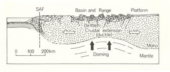
20 Overthrust fault, Near Banff, AB Combinations of faults: Horst and Grabens 20


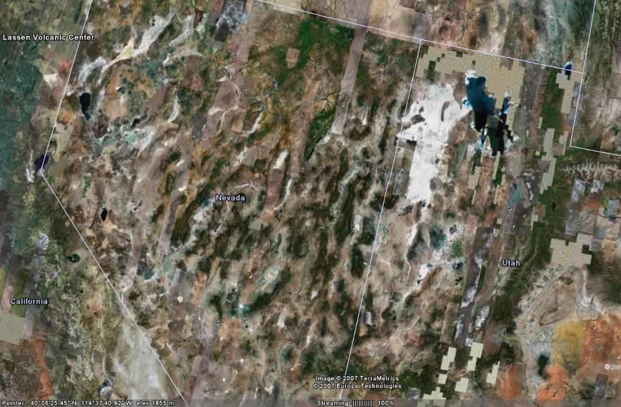
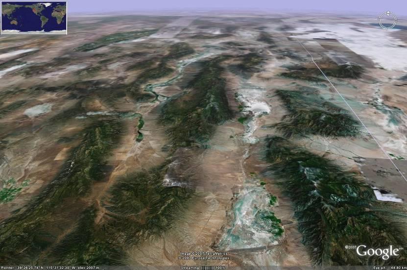
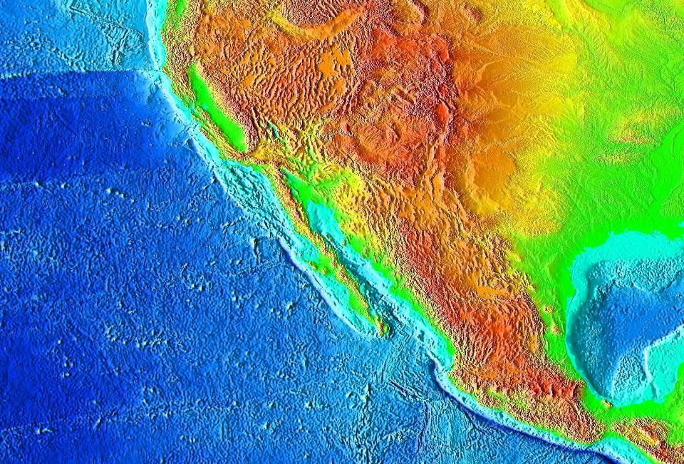
21 Basin and Range Geologic Province Portion of western NA plate crust that has undergone extension and upwarping Composed a horst/graben field that covers most of the western desert and includes the Great Basin 21
22 22


23 Horst/Graben terrain of Ceraunius Fossae, Mars Surface Expression of Igneous Activity As geomorphologists, we are primarily interested in the shapes produced by volcanic activity at the earth s surface. Puu Oo, a type of spatter cone, Kilauea, Hawaii 23

24 Types of Surface Expression of Igneous Activity 1) Extrusive: volcanic or depositional landforms Lava flows, ejecta, ash, volcanoes 2) Intrusive: igneous landforms exposed by erosion Batholiths, domes, dykes, sills Magma that was forced to surface and cooled is extrusive. Magma rose within the crust and cooled is intrusive. 24
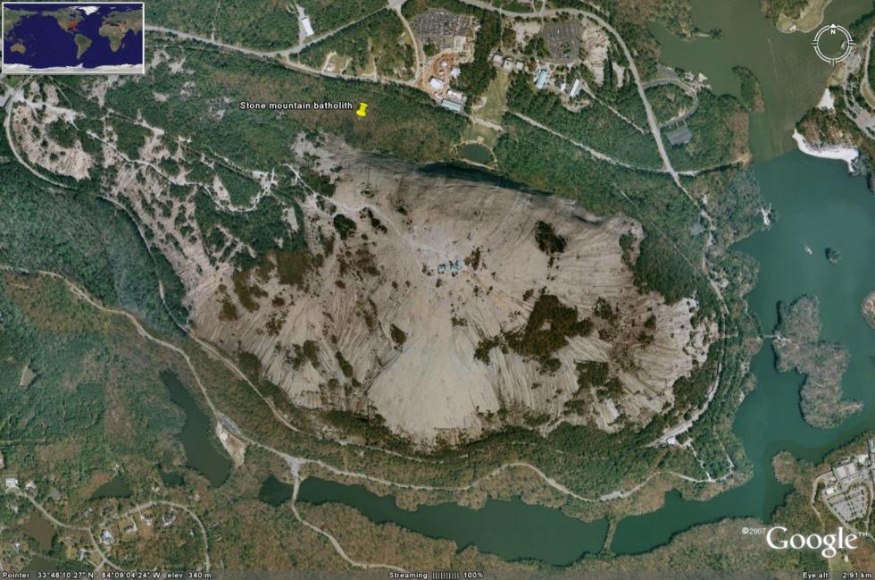
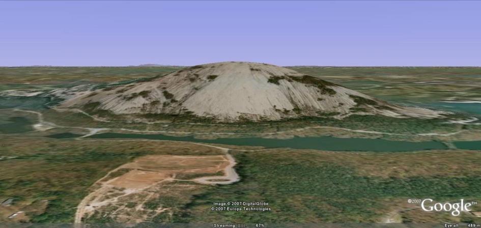
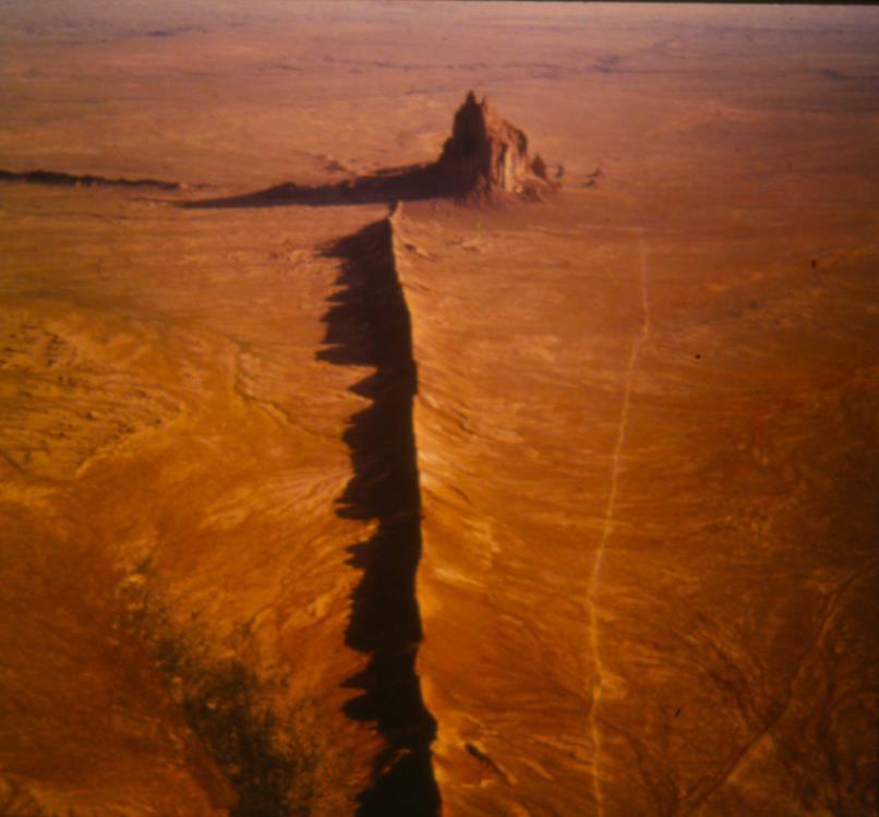
25 Batholith/stock Stone mountain, GA Dike Volcanic neck with radiating dike, Shiprock, NM 25


26 Types of extrusion 1. Lava flows 2. Pyroclastics 3. Ashflows Most extrusions are some combination of all three types of flow Pyroclastic flows descend the south-eastern flank of Mayon Volcano, Philippines 26


27 What controls the surface expression of volcanism? Characteristics of the magma 1. Composition of magma: Silica content controls the viscosity of the magma and, consequently likelihood that lava will flow and explosiveness. Basalt 50% SiO 2 ; Andesitic 60% SiO 2 ; Rhyolitic 70% SiO 2 ). More SiO 2 makes or more viscous flows 2. Magma Temperature: Also controls viscosity; hotter magma is less viscous. Melting point of Basalt 1100 o C. Melting point of Rhyolite o C. 3. Gas Content: Controls explosiveness and, ultimately, deposition patterns and flow types Geomorphology of lava flows Features: Lobate forms Irregular surface Solidified flow structures Lava levees (lateral ridges) Sharp differentiation between new and old flows 27
28 dz dt = U - E - qs All landscapes must obey this fundamental statement about sediment transport! Geomorphic transport laws In order to make predictions of landscape change Geomorphologists need to parameterize (E and qs): E includes: Sediment production by weathering (P) Bedrock erosion by glaciers, wind, water (W) q s includes erosion and deposition by: Mass wasting transport processes Fluvial transport processes Photo courtesy of Bill Dietrich The whole landscape in one equation! Additional reading for this week! 28
Questions and Topics
 Plate Tectonics and Continental Drift Questions and Topics 1. What are the theories of Plate Tectonics and Continental Drift? 2. What is the evidence that Continents move? 3. What are the forces that
Section 10.1 The Nature of Volcanic Eruptions This section discusses volcanic eruptions, types of volcanoes, and other volcanic landforms.
 Chapter 10 Section 10.1 The Nature of Volcanic Eruptions This section discusses volcanic eruptions, types of volcanoes, and other volcanic landforms. Reading Strategy Previewing Before you read the section,
Plate Tectonics. A. Continental Drift Theory 1. Early development 2. Alfred Wegener s mechanism
 Plate Tectonics A. Continental Drift Theory 1. Early development 2. Alfred Wegener s mechanism B. Seafloor Spreading 1. Earthquakes and volcanoes 2. Seafloor maps and dates 3. Continental drift revisited
8 th Grade Science Plate Tectonics and Topography Review
 8 th Grade Science Plate Tectonics and Topography Review #1 Scientists believe that the land masses of Earth were once joined together as one supercontinent called. A: Australia B: Wegner C: Pangaea D:
Before Plate Tectonics: Theory of Continental Drift
 Before Plate Tectonics: Theory of Continental Drift Predecessor to modern plate tectonics Shape and fit of the continents was the initial evidence Snider-Pelligrini (1858) Taylor (1908) Wegner (1915) Fig.
Chapter 10: Volcanoes and Other Igneous Activity Section 1: The Nature of Volcanic Eruptions I. Factors Affecting Eruptions Group # Main Idea:
 Chapter 10: Volcanoes and Other Igneous Activity Section 1: The Nature of Volcanic Eruptions I. Factors Affecting Eruptions Group # A. Viscosity Group # B. Dissolved Gases Group # II. Volcanic Material
Full file at
 Chapter 2 PLATE TECTONICS AND PHYSICAL HAZARDS MULTIPLE-CHOICE QUESTIONS 1. What direction is the Pacific Plate currently moving, based on the chain of Hawaiian Islands with only the easternmost island
Endogene processes and landforms NGEA01, 2018
 Endogene processes and landforms NGEA01, 2018 Cecilia Akselsson Department of Physical Geography and Ecosystem Science Lund University Endogene and exogene processes () Endogene/Internal/Constructive/Ulifting
A) B) C) D) 4. Which diagram below best represents the pattern of magnetic orientation in the seafloor on the west (left) side of the ocean ridge?
 B) C) D) 4. Which diagram below best represents the pattern of magnetic orientation in the seafloor on the west (left) side of the ocean ridge?") 1. Crustal formation, which may cause the widening of an ocean, is most likely occurring at the boundary between the A) African Plate and the Eurasian Plate B) Pacific Plate and the Philippine Plate C)
1. Crustal formation, which may cause the widening of an ocean, is most likely occurring at the boundary between the A) African Plate and the Eurasian Plate B) Pacific Plate and the Philippine Plate C)
12. The diagram below shows the collision of an oceanic plate and a continental plate.
 Review 1. Base your answer to the following question on the cross section below, which shows the boundary between two lithospheric plates. Point X is a location in the continental lithosphere. The depth
In 1912 Alfred Wegener proposed Continental Drift the continents have moved over time the continents were part of one giant landmass named Pangaea.
 Plate Tectonics In 1912 Alfred Wegener proposed Continental Drift the continents have moved over time the continents were part of one giant landmass named Pangaea. Pangaea Landmass movements over millions
Practice Questions: Plate Tectonics
 Practice Questions: Plate Tectonics 1. Base your answer to the following question on The block diagram below shows the boundary between two tectonic plates. Which type of plate boundary is shown? A) divergent
How mountains are made. We will talk about valleys (erosion and weathering later)
") How mountains are made We will talk about valleys (erosion and weathering later) http://www.ilike2learn.com/ilike2learn/mountainmaps/mountainranges.html Continent-continent plate convergence Less dense,
How mountains are made We will talk about valleys (erosion and weathering later) http://www.ilike2learn.com/ilike2learn/mountainmaps/mountainranges.html Continent-continent plate convergence Less dense,
Plate Tectonics. entirely rock both and rock
 Plate Tectonics I. Tectonics A. Tectonic Forces are forces generated from within Earth causing rock to become. B. 1. The study of the origin and arrangement of Earth surface including mountain belts, continents,
The Four Layers The Earth is composed of four different layers. The crust is the layer that you live on, and it is the most widely studied and
 Earth s Structure The Four Layers The Earth is composed of four different layers. The crust is the layer that you live on, and it is the most widely studied and understood. The mantle is much hotter and
How to Build a Mountain and other Geologic Structures. But first a short review
 How to Build a Mountain and other Geologic Structures But first a short review Where do we see deep earthquakes? What is happening there? What can happen at a plate boundary? 1. Plates can move apart
Geology 300, Physical Geology Spring 2019 Quiz Ch 19, Plate Tectonics Name
 Geology 300, Physical Geology Spring 2019 Quiz Ch 19, Plate Tectonics Name MULTIPLE CHOICE. Choose the one alternative that best completes the statement or answers the question. 1) The portion of a fracture
PHYSICAL GEOGRAPHY. By Brett Lucas
 PHYSICAL GEOGRAPHY By Brett Lucas INTERNAL PROCESSES Internal Processes The Impact of Internal Processes on the Landscape From Rigid Earth to Plate Tectonics Plate Tectonics Vulcanism Diastrophism Folding
Beneath our Feet: The 4 Layers of the Earty by Kelly Hashway
 Beneath our Feet: The 4 Layers of the Earty by Kelly Hashway The Earth is more than a giant ball made up of dirt, rocks, and minerals. The Earth may look like a giant ball from when looking at it from
Do NOT open the test until instructed to do so.
 Raw Score: Rank: School: Team Number: Names: Boyceville Invitational, December 2, 2017 Dynamic Planet Plate Tectonics and Geographical Impacts Do NOT open the test until instructed to do so. 2011 Tohoku
ANOTHER MEXICAN EARTHQUAKE! Magnitude 7.1, Tuesday Sept. 19, 2017
 ANOTHER MEXICAN EARTHQUAKE! Magnitude 7.1, Tuesday Sept. 19, 2017 Why is there no oceanic crust older than 200 million years? SUBDUCTION If new oceanic crust is being continuously created along the earth
Geology 1 st Semester Exam YSBAT
 1. What is the role of a geologist? Geology 1 st Semester Exam YSBAT 2016-2017 2. Earth is subdivided into three main layers based on what? 3. What features do you find at divergent boundaries? 4. Rock
Crustal Activity. Plate Tectonics - Plates - Lithosphere - Asthenosphere - Earth s surface consists of a major plates and some minor ones
 Name: Date: Period: Tectonics The Physical Setting: Earth Science CLASS NOTES Tectonics - s - Lithosphere - Asthenosphere - Earth s surface consists of a major plates and some minor ones The plates are
Plate Tectonics CHAPTER 17
 Plate Tectonics CHAPTER 17 Layers of the Earth A. Crust- solid, 5-70 km thick Moho Two Types of Crust: Oceanic- ocean floor, more dense then because of more iron Continental-dry land (mostly silicates
Plate Tectonics Tutoiral. Questions. Teacher: Mrs. Zimmerman. Plate Tectonics and Mountains Practice Test
 Teacher: Mrs. Zimmerman Print Close Plate Tectonics and Mountains Practice Test Plate Tectonics Tutoiral URL: http://www.hartrao.ac.za/geodesy/tectonics.html Questions 1. Fossils of organisms that lived
5. Convergent boundaries produce a relatively low number of earthquakes compared to other boundaries. a. True
 1. Earth s crust is thinner than its mantle. ANSWER: True 2. The concept of isostacy states that high-density rock will stand higher than low-density rock, which explains the formation of subduction zones.
Structure of the Earth
 Structure of the Earth Compositional (Chemical) Layers Crust: Low density Moho: Density boundary between crust and mantle Mantle: Higher density High in Magnesium (Mg) and Iron (Fe) Core: High in Nickel
Grand Unifying Theory of everything... for the Geosciences, at least!
 Plate Tectonics: Grand Unifying Theory of everything... for the Geosciences, at least! The Earth s lithosphere, composed of Oceanic and continental crust, is broken up into pieces that move and interact
Refer to the map on page 173 to answer the following questions.
 Chapter 8-1 Plate Tectonics 1. Brainstorm the type of evidence that would indicate a climate change and how this evidence supports the theory of continental drift. Tropical fossils in cold regions Evidence
Earth Science, (Tarbuck/Lutgens) Chapter 10: Mountain Building
 Chapter 10: Mountain Building") Earth Science, (Tarbuck/Lutgens) Chapter 10: Mountain Building 1) A(n) fault has little or no vertical movements of the two blocks. A) stick slip B) oblique slip C) strike slip D) dip slip 2) In a(n) fault,
Earth Science, (Tarbuck/Lutgens) Chapter 10: Mountain Building 1) A(n) fault has little or no vertical movements of the two blocks. A) stick slip B) oblique slip C) strike slip D) dip slip 2) In a(n) fault,
Mountain Building. Mountain Building
 Mountain Building Mountain building has occurred during the recent geologic past American Cordillera the western margin of the Americas from Cape Horn to Alaska Includes the Andes and Rocky Mountains Alpine
Rocks and the Rock Cycle. Banded Iron Formation
 Rocks and the Rock Cycle Banded Iron Formation Rocks Big rocks into pebbles, Pebbles into sand. I really hold a million, million Rocks here in my hand. Florence Parry Heide How do rocks change? How are
Plate Tectonics. Continental Drift Sea Floor Spreading Plate Boundaries
 Plate Tectonics Continental Drift Sea Floor Spreading Plate Boundaries Continental Drift 1915, Alfred Wegener - Pangea hypothesis: suggested Earth s continents were part of a large super-continent 200
Plate Tectonics. Earth has distinctive layers - Like an onion
 Plate Tectonics Earth has distinctive layers - Like an onion Earth s Interior Core: Metallic (Iron, Nickel) Inner (hot, solid, dense, Iron, Nickel) Outer (cooler, liquid, less dense) Crust (outermost layer):
UNIT 3 GEOLOGY VOCABULARY FLASHCARDS THESE KEY VOCABULARY WORDS AND PHRASES APPEAR ON THE UNIT 3 CBA
 UNIT 3 GEOLOGY VOCABULARY FLASHCARDS THESE KEY VOCABULARY WORDS AND PHRASES APPEAR ON THE UNIT 3 CBA A map that shows Earth s Topographic Map surface topography, which is Earth s shape and features Contour
Chapter 16. Mountain Building. Mountain Building. Mountains and Plate Tectonics. what s the connection?
 Chapter 16 Mountains and Plate Tectonics what s the connection? Mountain Building Most crustal deformation occurs along plate margins. S.2 Active Margin Passive Margin Mountain Building Factors Affecting
PLATE TECTONICS. Continental Drift. Continental Drift. Continental Drift. Continental Drift- Wegener s Evidence
 Continental Drift PLATE TECTONICS E.B. Taylor (1910) and Alfred Wegener (1915) published on Continental Drift. Continental Drift Wegener s evidence 1. Fit of the Continents 2. Fossil Evidence 3. Rock Type
NC Earth Science Essential Standards
 NC Earth Science Essential Standards EEn. 2.1 Explain how processes and forces affect the Lithosphere. EEn. 2.1.1 Explain how the rock cycle, plate tectonics, volcanoes, and earthquakes impact the Lithosphere.
How to Build a Mountain and other Geologic Structures. But first, questions
 How to Build a Mountain and other Geologic Structures But first, questions Questions your students might ask How were Montana s mountains formed? How old are the mountains? What are the different ways
Continental Drift. & Plate Tectonics
 Continental Drift & Plate Tectonics Alfred Wegener, a German scientist, proposed the hypothesis of CONTINENTAL DRIFT, in 1912. Hypothesis stated: All Earth s continents were once a single landmass (Pangaea)
TAKE HOME EXAM 8R - Geology
 Name Period Date TAKE HOME EXAM 8R - Geology PART 1 - Multiple Choice 1. A volcanic cone made up of alternating layers of lava and rock particles is a cone. a. cinder b. lava c. shield d. composite 2.
Convergent plate boundaries. Objective to be able to explain the formation and key features of these zones.
 Convergent plate boundaries Objective to be able to explain the formation and key features of these zones. Destructive plate margins When plates collide due to convection currents/slab pull in the asthenosphere
Plate Tectonics. Goal 2.1
 Plate Tectonics Goal 2.1 Lesson 1 Plate Tectonics: An Overview Think About It Look at the map below. Which two continents look like they d fit together? Focus Question How do Earth s tectonic plates cause
Lecture 3 Rocks and the Rock Cycle Dr. Shwan Omar
 Rocks A naturally occurring aggregate of one or more minerals (e.g., granite), or a body of non-crystalline material (e.g., obsidian glass), or of solid organic material (e.g., coal). Rock Cycle A sequence
Earth Systems Science Chapter 7. Earth Systems Science Chapter 7 11/11/2010. Seismology: study of earthquakes and related phenomena
 Earth Systems Science Chapter 7 I. Structure of the Earth II. Plate Tectonics The solid part of the earth system includes processes, just like the atmosphere and oceans. However, the time scales for processes
Foundations of Earth Science Seventh Edition
 Chapter 5 Lecture Outline Foundations of Earth Science Seventh Edition Plate Tectonics: A Scientific Revolution Unfolds Natalie Bursztyn Utah State University From Continental Drift to Plate Tectonics
Unit 11: Plate Tectonics
 Unit 11: Plate Tectonics A. Alfred Wegner 1. Continental drift hypothesis a. single supercontinent called Pangaea b. 200 million years ago Pangaea (all land) began to break up and started drifting to their
Plate Tectonics. I. The Discovery of Plate Tectonics II. A Mosaic of Plates III. Types of Plate Boundaries IV. How Plates Move
 Plate Tectonics I. The Discovery of Plate Tectonics II. A Mosaic of Plates III. Types of Plate Boundaries IV. How Plates Move I. The Discovery of Plate Tectonics A. Continental Drift (Alfred Wegener) Proposed
Crustal Boundaries. As they move across the asthenosphere and form plate boundaries they interact in various ways. Convergent Transform Divergent
 Name: Date: Period: Plate Tectonics The Physical Setting: Earth Science CLASS NOTES Tectonic plates are constantly moving and interacting As they move across the asthenosphere and form plate boundaries
Chapter 4: Plate Tectonics
 Chapter 4: Plate Tectonics K2 in the Himalaya, inset round submersible (beneath the submarine) that went to the Marianas Trench in 1960 http://www.nydailynews.com/news/world/james-cameron-presents-record-setting-deep-sea-expedition-article-1.1215139
The Dancing Plates: The Plate Tectonic Revolution
 The Dancing Plates: The Plate Tectonic Revolution The Rock Cycle igneous melting, cooling erosion, dep. melting, cooling baking, pressing sedimentary baking, pressing metamorphic erosion, dep. Earth: Compositional
Earth Movement and Resultant Landforms
 Earth Movement and Resultant Landforms Structure of the Earth Lithosphere : earth s crust Asthenosphere : upper mantle zone where material is near its melting point & acts almost like liquid (appprox.
* If occurs, fossils that formed in shallow water may be found in water. Subsidence mean the crust is.
 Name Notes: Topic 5B Topic 5B: The Dynamic Crust A. What evidence exists that proves the Earth s Crust is and has moved? Earth Science 1. Tilted, folded or faulted strata Strata is a term that refers to.
Essentials of Oceanography Eleventh Edition
 Chapter Chapter 1 2 Clickers Lecture Essentials of Oceanography Eleventh Edition Plate Tectonics and the Ocean Floor Alan P. Trujillo Harold V. Thurman Chapter Overview Much evidence supports plate tectonics
Sir Francis Bacon, 1620, noted that the continental coasts on opposites sides of the Atlantic fit together like puzzle pieces.
 Plate Tectonics Sir Francis Bacon, 1620, noted that the continental coasts on opposites sides of the Atlantic fit together like puzzle pieces. Could North and South America once have been joined to Europe
Earth s Structure. Earth has 4 layers. The inner core, outer core, mantle and crust. How do we know???
 Earth s Structure Earth has 4 layers. The inner core, outer core, mantle and crust. How do we know??? Adaptive Curriculum Determining Planet Layers from Seismic Waves Earth s Structure Scientists use earthquake
Lecture 4.1 Continental Drift
 Plate Tectonics Chapter 4 California Science Content Standards Covered: Big Ideas 3A: Students know the features of the ocean floor that provide evidence of plate tectonics Mid Ocean Ridges (ex. Mid Atlantic
Visualizing Earth Science. Chapter Overview. Volcanoes and Eruption Types. By Z. Merali and B. F. Skinner. Chapter 9 Volcanism and Other
 Visualizing Earth Science By Z. Merali and B. F. Skinner Chapter 9 Volcanism and Other Igneous Processes Volcanoes types and effects of eruption Chapter Overview Melting and cooling of rocks Geological
Evidence from the Surface. Chapter 02. Continental Drift. Fossil Evidence for Pangaea. Seafloor Spreading. Seafloor Spreading 1/31/2012
 Evidence from the Surface Surface landforms Continental shelf and slope Abyssal Plane Mid-oceanic ridge Oceanic Trenches Chapter 02 Continental Drift Continental Drift - a hypothesis that the continents
Alfred Wegener gave us Continental Drift. Fifty years later...
 CHAPTER 2 Plate Tectonics and the Ocean Floor Plate Tectonics: summary in haiku form Alfred Wegener gave us Continental Drift. Fifty years later... Words Chapter Overview Much evidence supports plate tectonics
Introduction to Oceanography. Chapter 2: Plate Tectonics Overview
 Introduction to Oceanography Chapter 2: Plate Tectonics Overview Much evidence supports plate tectonics theory. The plate tectonics model describes features and processes on Earth. Plate tectonic science
Lab 1: Plate Tectonics April 2, 2009
 Name: Lab 1: Plate Tectonics April 2, 2009 Objective: Students will be introduced to the theory of plate tectonics and different styles of plate margins and interactions. Introduction The planet can be
UNIT 11 PLATE TECTONICS
 UNIT 11 PLATE TECTONICS A. ALFRED WEGENER 1. Continental drift hypothesis Single supercontinent called Pangaea 200 million years ago Pangaea (all land) began to break up and started drifting to their present
Rock Cycle. Draw the Rock cycle on your remediation page OR use a sheet of notebook paper and staple
 Earth Science Test 8.ESS2.3) Describe the relationship between the processes and forces that create igneous, sedimentary, and metamorphic rocks. I can develop and use models to explain how plate movements
Plate Tectonics Practice Test
 Plate Tectonics Practice Test 1. What is the main idea Alfred Wegner proposed in the Theory of Continental Drift that he published in 1915? a. The continents float on a liquid layer that allows them to
Theory of Continental Drift
 Plate Tectonics Theory of Continental Drift Alfred Wegener suggested that continents had once been part of a supercontinent named Pangaea, that later broke up. The pieces moved apart over millions of years
Prentice Hall EARTH SCIENCE
 Prentice Hall EARTH SCIENCE Tarbuck Lutgens Chapter 9 Plate Tectonics 9.1 Continental Drift An Idea Before Its Time Wegener s continental drift hypothesis stated that the continents had once been joined
Prentice Hall EARTH SCIENCE
 Prentice Hall EARTH SCIENCE Tarbuck Lutgens Chapter 9 Plate Tectonics 9.1 Continental Drift An Idea Before Its Time Wegener s continental drift hypothesis stated that the continents had once been joined
Chapter 2 Plate Tectonics and the Ocean Floor
 Chapter 2 Plate Tectonics and the Ocean Floor Chapter Overview Much evidence supports plate tectonics theory. The plate tectonics model describes features and processes on Earth. Plate tectonic science
Chapter. Graphics by Tasa Graphic Arts. Inc.
 Earth Chapter Plate Science 9 Tectonics Graphics by Tasa Graphic Arts. Inc. 1 I. Earth s surface is made up of lithospheric plates. A. Lithospheric plates are composed of the crust and part of the upper
Directed Reading. Section: How Mountains Form MOUNTAIN RANGES AND SYSTEMS. Skills Worksheet
 Skills Worksheet Directed Reading Section: How Mountains Form 1. How high is Mount Everest? a. about 1980 km above sea level b. more than 8 km below sea level c. more than 8 km above sea level d. more
YORK CASTLE HIGH SCHOOL CHRISTMAS TERM EXAMINATIONS GEOGRAPHY Duration 1 1 /2 HRS.
 GRADE 9 YORK CASTLE HIGH SCHOOL CHRISTMAS TERM EXAMINATIONS GEOGRAPHY Duration 1 1 /2 HRS. Name: 1. Label the internal structure of the earth provided below. WRITE on the space provide. Oceanic Crust/Upper
Chapter 7 Plate Tectonics. Plate tectonics accounts for important features of Earth s surface and major geologic events.
 Chapter 7 Plate Tectonics Plate tectonics accounts for important features of Earth s surface and major geologic events. 7-2 Alfred Wegener s Hypothesis of Continental Drift (1915) He noticed that the continents
Ch. 9 Review. Pgs #1-31 Write Questions and Answers
 Ch. 9 Review Pgs. 356-357 #1-31 Write Questions and Answers 356-357 #1-5 Answers 1. The layer of the upper mantle that can flow is the: A - Asthenosphere 2. Most scientists rejected Wegener s theory of
COURSE OUTLINE GEOLOGY 101, Sec 002 Fall 2008, Diecchio Text: Lutgens, Tarbuck and Tasa, Essentials of Geology, 10 th edition
 COURSE OUTLINE GEOLOGY 101, Sec 002 Fall 2008, Diecchio Text: Lutgens, Tarbuck and Tasa, Essentials of Geology, 10 th edition Overview Of Earth ch 1 Earth's place in solar system, galaxy, universe Atmosphere,
PHYSICAL GEOLOGY AND THE ENVIRONMENT (2 ND CANADIAN EDITION)
") Chapter 2: Plate Tectonics Chapter Summary: Plate tectonics is a theory that suggests Earth's surface is divided into several large plates that change position and size. Intense geologic activity occurs
Chapter 2: Plate Tectonics Chapter Summary: Plate tectonics is a theory that suggests Earth's surface is divided into several large plates that change position and size. Intense geologic activity occurs
3. [ES 3] 1. [ST8.2] Some processes that shape Earth s surface are slow. Other processes are rapid. Which statement describes a rapid change?
![3. [ES 3] 1. [ST8.2] Some processes that shape Earth s surface are slow. Other processes are rapid. Which statement describes a rapid change?](/thumbs/89/98260180.jpg "3. [ES 3] 1. [ST8.2] Some processes that shape Earth s surface are slow. Other processes are rapid. Which statement describes a rapid change?") Science 8 SCIENCE QUARTERLY ASSESSMENT 2 3. [ES 3] S 1. [ST8.2] Some processes that shape Earth s surface are slow. Other processes are rapid. Which statement describes a rapid change? A. Glaciers melt
Science 8 SCIENCE QUARTERLY ASSESSMENT 2 3. [ES 3] S 1. [ST8.2] Some processes that shape Earth s surface are slow. Other processes are rapid. Which statement describes a rapid change? A. Glaciers melt
PLATE TECTONICS. SECTION 17.1 Drifting Continents
 Date Period Name PLATE TECTONICS SECTION.1 Drifting Continents In your textbook, read about continental drift. Circle the letter of the choice that best completes each statement. 1. Early mapmakers thought
Plate Tectonic Theory
 Have you ever looked at a world map and noticed the shapes of the continents? Have you ever noticed how some continents appear to fit together like the pieces of a jigsaw puzzle? Why do you think this
Evolution of Continents Chapter 20
 Evolution of Continents Chapter 20 Does not contain complete lecture notes. Mountain belts Orogenesis the processes that collectively produce a mountain belt Includes folding, thrust faulting, metamorphism,
Theory of Plate Tectonics
 Plate Tectonics Theory of Plate Tectonics Lithosphere is made of sections called plates that move around called continental drift Plates move because they float on the asthenosphere Most plates consist
Earth/Space Honors EOC Pacing Guide
 Lesson Vocabulary NGSSS Minerals Understand the physical and chemical properties that define and identify a mineral. Chemical formula Luster Cleavage Fracture Hardness Streak Specific gravity Solid Inorganic
NAME HOMEWORK ASSIGNMENT #4 MATERIAL COVERS CHAPTERS 19, 20, 21, & 2
 NAME HOMEWORK ASSIGNMENT #4 MATERIAL COVERS CHAPTERS 19, 20, 21, & 2 Assignment is due the beginning of the class period on December 14, 2004. Mark answers on a scantron sheet, which will be provided.
Section 1: Earth s Interior and Plate Tectonics Section 2: Earthquakes and Volcanoes Section 3: Minerals and Rocks Section 4: Weathering and Erosion
 Section 1: Earth s Interior and Plate Tectonics Section 2: Earthquakes and Volcanoes Section 3: Minerals and Rocks Section 4: Weathering and Erosion Key Terms Crust Mantle Core Lithosphere Plate Tectonics
6. In the diagram below, letters A and B represent locations near the edge of a continent.
 1. Base your answer to the following question on the cross section below and on your knowledge of Earth science. The cross section represents the distance and age of ocean-floor bedrock found on both sides
Plate Tectonics. By Destiny, Jarrek, Kaidence, and Autumn
 Plate Tectonics By Destiny, Jarrek, Kaidence, and Autumn .The Denali Fault and San Andreas Fault - The San Andreas Fault is a continental transform fault that extends roughly 1300 km (810 miles) through
Plate Boundaries & Resulting Landforms
 Plate Boundaries & Resulting Landforms Divergent Plate Boundaries (plates being pulled apart) Type: oceanic plates Description: rising magma gently lifts the crust creating a ridge. The flow of convection
STUDY GUIDE FOR MID-TERM EXAM KEY. Color, luster, cleavage, fracture, hardness, taste, smell, fluorescence, radioactivity, magnetism
 STUDY GUIDE FOR MID-TERM EXAM KEY 1. In which type of rock are fossils most likely to be found? Sedimentary Rocks 2. Which mineral is easily identified by smell? Sulfur 3. Which natural resource makes
Continental Drift. Wegener theory that the crustal plates are moving and once were a super continent called Pangaea.
 PLATE TECTONICS WHAT IS TECTONICS? Tectonism is the faulting or folding or other deformation of the outer layer of a planet. It happens very slowly, on the scale of millions of years. Tectonic activity
Plate Tectonics. These icons indicate that teacher s notes or useful web addresses are available in the Notes Page.
 Plate Tectonics These icons indicate that teacher s notes or useful web addresses are available in the Notes Page. This icon indicates the slide contains activities created in Flash. These activities are
Continental Drift and Plate Tectonics
 Continental Drift and Plate Tectonics Continental Drift Wegener s continental drift hypothesis stated that the continents had once been joined to form a single supercontinent. Wegener proposed that the
SUBSURFACE CHANGES TO EARTH. Ms. Winkle
 SUBSURFACE CHANGES TO EARTH Ms. Winkle OVERVIEW Subsurface events: occurring inside the crust and mantle Moving the lithosphere due to the convection currents in the asthenosphere Main Theories: 1912 Wegener,
Lecture Outline Friday January 12 Friday January 19, 2018
 Lecture Outline Friday January 12 Friday January 19, 2018 Questions?? Key Points for today The structure of the Earth Introduction to Plate Tectonic Theory and Convection Chapter 2 Development of the Plate
Plate Boundaries. Presented by Kesler Science
 Presented by Kesler Science Essential Questions: 1. What is plate tectonics? 2. What are the three types of plate boundaries? 3. What crustal features are formed at plate boundaries? Quick Action INB Template
4 Layers of the earth 7 main plates of the earth 3 main plate boundaries 2 types of crust 3 main features of plate tectonics 3 main theorists and
 4 Layers of the earth 7 main plates of the earth 3 main plate boundaries 2 types of crust 3 main features of plate tectonics 3 main theorists and theories Human interaction The Earth is made up of 3 main
PALEOGEOGRAPHY of NYS. Definitions GEOLOGIC PROCESSES. Faulting. Folding 9/6/2012. TOPOGRAPHIC RELIEF MAP of NYS GRADATIONAL TECTONIC
 TOPOGRAPHIC RELIEF MAP of NYS PALEOGEOGRAPHY of NYS Prof. Anthony Grande AFG 2012 Definitions GEOLOGIC PROCESSES Geography: study of people living on the surface of the earth. Geology: the scientific study
Plate Tectonics. Essentials of Geology, 11 th edition Chapter 15
 1 Plate Tectonics Essentials of Geology, 11 th edition Chapter 15 2 3 4 5 6 7 8 9 10 11 12 13 14 15 Plate Tectonics: summary in haiku form Alfred Wegener gave us Continental Drift. Fifty years later...
World Geography 3202 Unit 1. Ch. 1: Landform Patterns and Processes
 World Geography 3202 Unit 1 Ch. 1: Landform Patterns and Processes - Planet Earth is dynamic - behaves as if it s a living organism - some changes are rapid enough for us to see and record - exs. Tidal
Unit 4 Lesson 6 Plate Tectonics
 Unit 4 Lesson 6 Plate Tectonics Indiana Standards 7.2.1 Describe how the earth is a layered structure composed of lithospheric plates, a mantle and a dense core. 7.2.4 Explain how convection currents in
Physical Geography. Physical Geography. Physical Landscape I of the United States and Canada. Definitions. Physical Geography GEOLOGIC PROCESSES
 Physical Landscape I of the United States and Canada Physical Geography Physical landscape (natural environment) sets the stage for human use (the cultural landscape). Prof. Anthony Grande AFG 2016 Landforms