Earthquake Tectonics and Hazards on the Continents June Recognizing and characterizing strike-slip faults and earthquakes in USA
|
|
|
- Shona Bridges
- 5 years ago
- Views:
Transcription


1 Earthquake Tectonics and Hazards on the Continents June 2013 Recognizing and characterizing strike-slip faults and earthquakes in USA S. G. Wesnousky Univ. of Nevada USA
2 Strike-slip Faults Geomorphic Expression, Slip Rate, and Repeat Time Trieste 2013 Wesnousky

3 Physiograhy Geomorphology and Faulting
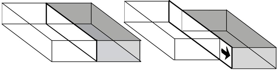
4 A Strike-Slip Fault
5 This with Configuration PixMap the current cannot Hardware/Software be displayed A o Fault B An earthquake is the result of a sudden displacement across a fault that releases stresses that have accumulated in the crust of the earth. C o


6 Mckay s 1890 report on the 1888 Hope Fault Earthquake, NewZealand Koto s 1893 report on the 1891 Neodani Earthquake, Japan Gilbert s 1884 paper on theorey of earthquakes in the Great Basin and 1910 account of the 1906 San Francisco earthquake, United States.


7 1992 Landers 1992 d 1999 Hector Mine
8 Calculation of slip rate and earthquake repeat time The repetition of this process results in distinct geomorphic features along fault zones that may be interpreted by geologists To determine the rate, style, and magnitude of fault slip
9

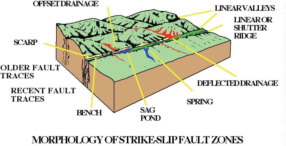
10 San Andreas Rift Strike-slip displacement juxtaposition of topography cataclasis and weakening of rock in fault zone stream capture along fault Pt. Arena preferential erosion along fault leads to long linear ridges and valleys... Pt. Reyes

11 Gualala River View North to Coast
12 Tomales and Bolinas Bays north of San Francisco Bay

13 San Andreas Lake

14 Central San Andreas Carrizo Plain Monterey

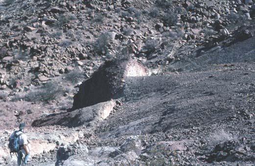
15 example of offset stream

16 San Andreas is Carrizo Plain linearity of trace alternate-facing scarps San Andreas

17 linearity of trace alternate-facing scarps sag ponds Sag Ponds

18 Cataclasis in fault zone leads to increase in volume of sediments - Small component of contraction in additon to strike-slip can lead to uplift and folding along fault zone - sometimes referred to as flower structure

19 linear trace in Carrizo Plain

20 Incision on hanging/uplifted wall... offset and abandoned streams
,")
21 Channel abandoned 3700 ybp 128 meters Calculation of fault slip rate... San Andreas slip rate = 128m / 3700 years = ~ 34 mm/yr Sieh and Jahns (1984), GSAB v. 95,
, GSAB v.")
22 Offsets D = 9 to 12 m interpreted to be result of single earthquake... Calculation of Repeat Time... Average Repeat Time = 9 to 12 m / ~34 mm/yr = 250 to 450 years Sieh and Jahns (1984), GSAB v. 95,

, JGR, v.")
23 Offset and beheaded stream Slip Rate = ~210m / ~17kyr = ~ 12 mm/yr Rockwell et al (1990), JGR, v. 95,
24 Strike Slip Faults are often long and quite linear - but they are not always continuous
25 San Andreas D=150 km 1&12: SAN ANDREAS FAULT: SS 150 KM; LENGTH ~ 1000 KM Pt. Arena to Belmont N Pt. Arena Pacific Ocean Los Gatos to Cholame N San Juan Bautista Los Gatos Bitterwater Cholame to Little Rock Reservoir 0 km 50 Cholame N Pearblossom to Bombay Beach Pearblossom Garlock Fault D=64 km 2: GARLOCK FAULT; SS~ 64KM; Length ~ 240KM Step~3km Koehn Lake Fremont Valley 0 km 50 Step ~1/2km Searles Valley 5: SAN JACINTO FAULT: SS 25 KM; LENGTH ~ 230KM CLARE BORREGO SUPERSTITION MONT km Step: ~ 5km SAN Loma Linda ANDREAS Wrightwood Cajon Pass Yucaipa San Jacinto D=25 km CASA LOMA CLARKE Step ~ 4km Hemet Step ~ 4kmCOYOTE Steps ~ 5km & 1 km N Golden Gate Parkfield Step~1km Indio Cholame Little Rock Little Rock Reservoir Los Gatos BomBay Beach N N Strike-Slip Faults of California Structural Evolution of Faults Long, and linear, Fault but Systems? NOT continuous Seismological D estimate of total Evolution strike-slip since birth of Faults fault and Fault Systems? Whittier-Elsinore D~15 km 4: WHITTIER-ELSINORE FAULT ZONE: SS 10-15KM; LENGTH ~ 240KM N CoronaStep:~3km Agua Tibia Mtn. Step:~3km WHITTIER Lake Elsinore 0 km 50 Baldwin Hills Rosecran Hills Step: ~ 2km Step: ~ 3km 0 km 20 Dominguez Hills Signal Steps: ~ 2km Hill Step:~3km Coyote Mtns. Newport-Inglewood D=10 km 3: NEWPORT- INGLEWOOD FAULT: SS~0.2-10KM; LENGTH = 60KM N FAULT SANTA MONICA Long Beach Pacific Ocean Newport Beach LAGUNA SALADA
26 Structural Evolution of Faults - tend to simplify with accumulated offset
27 Complexity (steps/km) (0-1 steps/75km) Turkey China Japan N. Calif. New Zealand S. and Baja Calif Cumulative Strike-Slip (km)
28 How do discontinuities (steps) in fault trace effect the propagation of earthquake ruptures? extension contraction
29 can be important to hazard analysis... Compilation of 20+ strike-slip surface-rupture earthquakes..

30 Is termination of STRIKE-SLIP rupture associated with step in fault trace of dimension >=1km or end of active fault trace?


31 Summary of behavior of all discontinuities along strike of historical earthquake ruptures.
Geo736: Seismicity and California s Active Faults Introduction
 Geo736: Seismicity and California s Active Faults Course Notes: S. G. Wesnousky Spring 2018 Introduction California sits on the boundary of the Pacific - North American plate boundary (Figure 1). Relative
Yesterday scaling laws. An important one for seismic hazard analysis
 Yesterday scaling laws An important one for seismic hazard analysis Estimating the expected size of an earthquake expected on a fault for which the mapped length is known. Wells & Coppersmith, 1994 And
Tectonic geomorphology
 Tectonic geomorphology studies processes and landforms controlled by tectonics Change in landscape caused by change in landscape process Look for morphological anomalies surfaces warped, tilted, uplifted,
Earthquakes and Faulting
 Earthquakes and Faulting Crustal Strength Profile Quakes happen in the strong, brittle layers Great San Francisco Earthquake April 18, 1906, 5:12 AM Quake lasted about 60 seconds San Francisco was devastated
Learning goals - January 16, Describe the geometry of a fault (1) orientation of the plane (strike and dip) (2) slip vector
 orientation of the plane (strike and dip) (2) slip vector") Learning goals - January 16, 2012 You will understand how to: Describe the geometry of a fault (1) orientation of the plane (strike and dip) (2) slip vector Understand concept of slip rate and how it is
Learning goals - January 16, 2012 You will understand how to: Describe the geometry of a fault (1) orientation of the plane (strike and dip) (2) slip vector Understand concept of slip rate and how it is
Jack Loveless Department of Geosciences Smith College
 Geodetic constraints on fault interactions and stressing rates in southern California Jack Loveless Department of Geosciences Smith College jloveless@smith.edu Brendan Meade Department of Earth & Planetary
CHAPTER 1 BASIC SEISMOLOGY AND EARTHQUAKE TERMINOLGY. Earth Formation Plate Tectonics Sources of Earthquakes...
 CHAPTER 1 BASIC SEISMOLOGY AND EARTHQUAKE TERMINOLGY Earth Formation... 1-2 Plate Tectonics... 1-2 Sources of Earthquakes... 1-3 Earth Faults... 1-4 Fault Creep... 1-5 California Faults... 1-6 Earthquake
A GEOLOGIC TRIP to the SAN ANDREAS FAULT
 A GEOLOGIC TRIP to the SAN ANDREAS FAULT San Andreas Hot Spot Loop Road Hot Spot P Parking San Andreas Fault Interpretive Trail Fault Zone Map: San Andreas Fault Zone During the 25 million years that the
Kinematics of the Southern California Fault System Constrained by GPS Measurements
 Title Page Kinematics of the Southern California Fault System Constrained by GPS Measurements Brendan Meade and Bradford Hager Three basic questions Large historical earthquakes One basic question How
A Model of Three Faults
 A Model of Three Faults Grades 7-12 Adapted from the USGS Learning Web Lesson Plans Background One of the most frightening and destructive phenomena of nature is a severe earthquake and its terrible aftereffects.
Basin & Range / Mojave Desert
 Basin & Range / Mojave Desert Basin & Range vs. Great Basin 1 2/20/2016 An overview of the last horst Basin and Range / Mojave Desert Summary: Granitic, volcanic, marine sedimentary, non marine sedimentary,
Apparent and True Dip
 Apparent and True Dip Cross-bedded building stone. The contact immediately below A appears to dip gently to the right, but at B, the contact appears to dip to the left. But it's not a syncline! Both of
Fault Specific, Dynamic Rupture Scenarios for Strong Ground Motion Prediction
 Fault Specific, Dynamic Rupture Scenarios for Strong Ground Motion Prediction H. Sekiguchi Disaster Prevention Research Institute, Kyoto University, Japan Blank Line 9 pt Y. Kase Active Fault and Earthquake
From Earthquakes to Mountains: the Earth s Crust in Motion
 Dean s Freshman Honor Seminar (SCI 110) Eric Calais Associate Professor of Geophysics Purdue University Department of Earth and Atmospheric Sciences ecalais@purdue.edu http:/www.eas.purdue.edu/~calais
Today: Basic regional framework. Western U.S. setting Eastern California Shear Zone (ECSZ) 1992 Landers EQ 1999 Hector Mine EQ Fault structure
 1992 Landers EQ 1999 Hector Mine EQ Fault structure") Today: Basic regional framework Western U.S. setting Eastern California Shear Zone (ECSZ) 1992 Landers EQ 1999 Hector Mine EQ Fault structure 1 2 Mojave and Southern Basin and Range - distribution of strike-slip
Today: Basic regional framework Western U.S. setting Eastern California Shear Zone (ECSZ) 1992 Landers EQ 1999 Hector Mine EQ Fault structure 1 2 Mojave and Southern Basin and Range - distribution of strike-slip
MAR110 Lecture #5 Plate Tectonics-Earthquakes
 1 MAR110 Lecture #5 Plate Tectonics-Earthquakes Figure 5.0 Plate Formation & Subduction Destruction The formation of the ocean crust from magma that is upwelled into a pair of spreading centers. Pairs
Part 2 - Engineering Characterization of Earthquakes and Seismic Hazard. Earthquake Environment
 Part 2 - Engineering Characterization of Earthquakes and Seismic Hazard Ultimately what we want is a seismic intensity measure that will allow us to quantify effect of an earthquake on a structure. S a
Hosgri-San Simeon Fault Zone Geologic Slip Rate
 Hosgri-San Simeon Fault Zone Geologic Slip Rate Insert picture(s) here Kathryn Hanson AMEC E&I Diablo Canyon SSHAC Project SSC Workshop 2 November 7, 2012 What insights have your geologic investigations
A Time-Dependent Probabilistic Seismic-Hazard Model for California
 Bulletin of the Seismological Society of America, 90, 1, pp. 1 21, February 2000 A Time-Dependent Probabilistic Seismic-Hazard Model for California by Chris H. Cramer,* Mark D. Petersen, Tianqing Cao,
The Seismogenic Thickness of the Southern California Crust
 Bulletin of the Seismological Society of America, Vol. 94, No. 3, pp. 940 960, June 2004 The Seismogenic Thickness of the Southern California Crust by Julie J. Nazareth and Egill Hauksson Abstract The
to: Interseismic strain accumulation and the earthquake potential on the southern San
 Supplementary material to: Interseismic strain accumulation and the earthquake potential on the southern San Andreas fault system by Yuri Fialko Methods The San Bernardino-Coachella Valley segment of the
Lecture # 6. Geological Structures
 1 Lecture # 6 Geological Structures ( Folds, Faults and Joints) Instructor: Dr. Attaullah Shah Department of Civil Engineering Swedish College of Engineering and Technology-Wah Cantt. 2 The wavy undulations
GEOLOGY MEDIA SUITE Chapter 13
 UNDERSTANDING EARTH, SIXTH EDITION GROTZINGER JORDAN GEOLOGY MEDIA SUITE Chapter 13 Earthquakes 2010 W.H. Freeman and Company Three different types of seismic waves are recorded by seismographs Key Figure
3. Landforms related to different types of movements
 3. Landforms related to different types of movements Faults / Zlomy 3 types of faults under different stress regimes (napěťových režimech): poklesové zlomy (normal fault), přesmykové zlomy (reverse fault,
Description of faults
 GLG310 Structural Geology Description of faults Horizontal stretch Crustal thickness Regional elevation Regional character Issues Normal Thrust/reverse Strike-slip >1 1 in one direction and < 1 in
PROBABILISTIC SURFACE FAULT DISPLACEMENT HAZARD ANALYSIS (PFDHA) DATA FOR STRIKE SLIP FAULTS
 DATA FOR STRIKE SLIP FAULTS") PROBABILISTIC SURFACE FAULT DISPLACEMENT HAZARD ANALYSIS (PFDHA) DATA FOR STRIKE SLIP FAULTS PEER SURFACE FAULT DISPLACEMENT HAZARD WORKSHOP U.C. Berkeley May 20-21, 2009 Timothy Dawson California Geological
PROBABILISTIC SURFACE FAULT DISPLACEMENT HAZARD ANALYSIS (PFDHA) DATA FOR STRIKE SLIP FAULTS PEER SURFACE FAULT DISPLACEMENT HAZARD WORKSHOP U.C. Berkeley May 20-21, 2009 Timothy Dawson California Geological
Earth Science, (Tarbuck/Lutgens) Chapter 10: Mountain Building
 Chapter 10: Mountain Building") Earth Science, (Tarbuck/Lutgens) Chapter 10: Mountain Building 1) A(n) fault has little or no vertical movements of the two blocks. A) stick slip B) oblique slip C) strike slip D) dip slip 2) In a(n) fault,
Earth Science, (Tarbuck/Lutgens) Chapter 10: Mountain Building 1) A(n) fault has little or no vertical movements of the two blocks. A) stick slip B) oblique slip C) strike slip D) dip slip 2) In a(n) fault,
Earthquakes and Earthquake Hazards Earth - Chapter 11 Stan Hatfield Southwestern Illinois College
 Earthquakes and Earthquake Hazards Earth - Chapter 11 Stan Hatfield Southwestern Illinois College What Is an Earthquake? An earthquake is the vibration of Earth, produced by the rapid release of energy.
Appendix C - Geotechnical Report. Landmark Consultants, Inc.
 Appendix C - Geotechnical Report Landmark Consultants, Inc. LCI Report No. LP18128 Fault Map Regional Review of the current Alquist-Priolo Earthquake Fault Zone maps (CGS, 2000a) indicates that
EPS 50 Lab 5 The Hayward Fault at UC Berkeley
 EPS 50 Lab 5 The Hayward Fault at UC Berkeley Introduction: On this field trip we will see some of the most dramatic expressions of the Hayward Fault in the Berkeley area. Most of the subtle geomorphic
Active Tectonics. Earthquakes, Uplift, and Landscape. Edward A. Keller University of California, Santa Barbara
 Prentice Hall Earth Science Series SUB Gottingen 214 80416X, im ^, 2002 A 7883 lllllllilwii Active Tectonics Earthquakes, Uplift, and Landscape Second Edition V Edward A. Keller University of California,
Precarious Rocks Methodology and Preliminary Results
 FINAL TECHNICAL REPORT Precarious Rocks Methodology and Preliminary Results James N. Brune, Rasool Anooshehpoor, Yuehua Zeng, and John G. Anderson Seismological Laboratory University of Nevada, Reno Reno,
depression above scarp scarp
 1 LAB 1: FIELD TRIP TO McKINLEYVILLE AND MOUTH OF THE MAD RIVER OBJECTIVES: a. to look at geomorphic and geologic evidence for large scale thrust-faulting of young sediments in the Humboldt Bay region
Plate Boundary Observatory Working Group for the Central and Northern San Andreas Fault System PBO-WG-CNSA
 Plate Boundary Observatory Working Group for the Central and Northern San Andreas Fault System PBO-WG-CNSA Introduction Our proposal focuses on the San Andreas fault system in central and northern California.
EARTHQUAKE LOCATIONS INDICATE PLATE BOUNDARIES EARTHQUAKE MECHANISMS SHOW MOTION
 6-1 6: EARTHQUAKE FOCAL MECHANISMS AND PLATE MOTIONS Hebgen Lake, Montana 1959 Ms 7.5 1 Stein & Wysession, 2003 Owens Valley, California 1872 Mw ~7.5 EARTHQUAKE LOCATIONS INDICATE PLATE BOUNDARIES EARTHQUAKE
Overview of the Seismic Source Characterization for the Palo Verde Nuclear Generating Station
 Overview of the Seismic Source Characterization for the Palo Verde Nuclear Generating Station Scott Lindvall SSC TI Team Lead Palo Verde SSC SSHAC Level 3 Project Tuesday, March 19, 2013 1 Questions from
Earthquakes. Chapter Test A. Multiple Choice. Write the letter of the correct answer on the line at the left.
 Earthquakes Chapter Test A Multiple Choice Write the letter of the correct answer on the line at the left. 1. Stress that pushes a mass of rock in two opposite directions is called a. shearing. b. tension.
Earthquakes Earth, 9th edition, Chapter 11 Key Concepts What is an earthquake? Earthquake focus and epicenter What is an earthquake?
 1 2 3 4 5 6 7 8 9 10 Earthquakes Earth, 9 th edition, Chapter 11 Key Concepts Earthquake basics. "" and locating earthquakes.. Destruction resulting from earthquakes. Predicting earthquakes. Earthquakes
Plates & Boundaries The earth's continents are constantly moving due to the motions of the tectonic plates.
 Plates & Boundaries The earth's continents are constantly moving due to the motions of the tectonic plates. As you can see, some of the plates contain continents and others are mostly under the ocean.
John Baldwin and Brian Gray Lettis Consultants International, Inc. Alexis Lavine AMEC Josh Goodman and Janet Sowers Fugro Consultants, Inc.
 John Baldwin and Brian Gray Lettis Consultants International, Inc. Alexis Lavine AMEC Josh Goodman and Janet Sowers Fugro Consultants, Inc. December 1, 2011 Pacific Gas & Electric SSHAC Workshop 1 San
Deformation of Rocks. Orientation of Deformed Rocks
 Deformation of Rocks Folds and faults are geologic structures caused by deformation. Structural geology is the study of the deformation of rocks and its effects. Fig. 7.1 Orientation of Deformed Rocks
Stress modulation on the San Andreas fault by interseismic fault system interactions Jack Loveless and Brendan Meade, Geology, 2011
 Stress modulation on the San Andreas fault by interseismic fault system interactions Jack Loveless and Brendan Meade, Geology, 2011 A three step process: 1 - Assimilate plate boundary wide GPS data into
Earthquakes. Building Earth s Surface, Part 2. Science 330 Summer What is an earthquake?
 Earthquakes Building Earth s Surface, Part 2 Science 330 Summer 2005 What is an earthquake? An earthquake is the vibration of Earth produced by the rapid release of energy Energy released radiates in all
Earth s Magnetic Field Differential Rotation between the inner core and the outer core.
 Geology 15 Lecture 7 Schedule: Hazard Update: Review Lecture 6 Activity 2 cont: Plate Boundaries and Their Motions Cover Material/Objectives Plate Tectonics (continued) Earth s Structure Evidence for Continental
ETH Swiss Federal Institute of Technology Zürich
 Swiss Federal Institute of Technology Zürich Earthquake Statistics using ZMAP Recent Results Danijel Schorlemmer, Stefan Wiemer Zürich, Swiss Seismological Service, Switzerland Contributions by: Matt Gerstenberger
Crustal Deformation. Earth Systems 3209
 Crustal Deformation Earth Systems 3209 Crustal Deformation pg. 415 Refers to all changes in the original form and/or size of a rock body. May also produce changes in the location and orientation of rocks.
Annual Report 2000 Comparing Mechanical and Geodetic Models of Los Angeles Basin Faults. Amherst, MA Los Angeles, CA 90089
 Annual Report 2000 Comparing Mechanical and Geodetic Models of Los Angeles Basin Faults Michele Cooke Susan Owen University of Massachsetts Amherst University of Southern California Amherst, MA 01003-5820
Earthquakes. Pt Reyes Station 1906
 Earthquakes Pt Reyes Station 1906 Earthquakes Ground shaking caused by the sudden release of accumulated strain by an abrupt shift of rock along a fracture in the earth. You Live in Earthquake Country
Introduction Faults blind attitude strike dip
 Chapter 5 Faults by G.H. Girty, Department of Geological Sciences, San Diego State University Page 1 Introduction Faults are surfaces across which Earth material has lost cohesion and across which there
ENVIRONMENTAL IMPACT ANALYSIS C. GEOLOGY
 IV. ENVIRONMENTAL IMPACT ANALYSIS C. GEOLOGY This section summarizes the results of a geotechnical evaluation conducted for the proposed project by Jerry Kovacs and Associates, Inc. in August 1996. The
JOURNAL OF GEOPHYSICAL RESEARCH, VOL. 102, NO. Bll, PAGES 24,411-24,435, NOVEMBER 10, 1997
 JOURNAL OF GEOPHYSICAL RESEARCH, VOL. 102, NO. Bll, PAGES 24,411-24,435, NOVEMBER 10, 1997 Stress evolution in southern California and triggering of moderate-, small-, and micro-size earthquakes Jishu
A physical feature of the Earth s surface
 Earth s Landforms A physical feature of the Earth s surface A physical feature of the Earth s surface LANDFORM Highest of Earth s physical features Highest of Earth s physical features MOUNTAIN Low area
Earthquakes Chapter 19
 Earthquakes Chapter 19 Does not contain complete lecture notes. What is an earthquake An earthquake is the vibration of Earth produced by the rapid release of energy Energy released radiates in all directions
The largest and longest of the geologic faults in California is the San Andreas Fault which slices in a southeasterly to northwesterly direction
 [RADIOCARBON, VOL 22, No. 3, 1980, P 746-756] RADIOCARBON DATING OF EARTHQUAKES RAINER BERGER and THOMAS S KAUFMAN Institute of Geophysics and Planetary Physics, Department of Anthropology and Geography,
The Bridge from Earthquake Geology to Earthquake Seismology
 The Bridge from Earthquake Geology to Earthquake Seismology Computer simulation Earthquake rate Fault slip rate Magnitude distribution Fault geometry Strain rate Paleo-seismology David D. Jackson djackson@g.ucla.edu
1. occurs when the oceanic crust slides under the continental crust.
 1. occurs when the oceanic crust slides under the continental crust. 2. What type of stress is shown? 3. Where two plates slide past one another is called a boundary. 4. What type of stress is shown? 5.
EVALUATION OF TSUNAMI RISK FOR COASTAL SOUTHERN CALIFORNIA CITIES. Appendix A - Figures
 EVALUATION OF TSUNAMI RISK FOR COASTAL SOUTHERN CALIFORNIA CITIES Appendix A - Figures Figure 1.Map showing major faults of the southern California region. Northwest-trending faults are rightslip in character.
MAR110 LECTURE #6 West Coast Earthquakes & Hot Spots
 17 September 2007 Lecture 6 West Coast Earthquakes & Hot Spots 1 MAR110 LECTURE #6 West Coast Earthquakes & Hot Spots Figure 6.1 Plate Formation & Subduction Destruction The formation of the ocean crust
Quaternary Processes of the Monterey Bay Area Field Trip Notes
 Quaternary Processes of the Monterey Bay Area Field Trip Notes A color version of this field trip guide, with directions is available at: http://www.mpcfaculty.net/alfred_hochstaedter/geology.htm Click
Learning Objectives (LO) What we ll learn today:!
 What we ll learn today:!") Learning Objectives (LO) Lecture 13: Mountain Building Read: Chapter 10 Homework #11 due Tuesday 12pm What we ll learn today:! 1. Define the types of stress that are present in the crust! 2. Define the
Learning Objectives (LO) Lecture 13: Mountain Building Read: Chapter 10 Homework #11 due Tuesday 12pm What we ll learn today:! 1. Define the types of stress that are present in the crust! 2. Define the
Earthquakes. Earthquake Magnitudes 10/1/2013. Environmental Geology Chapter 8 Earthquakes and Related Phenomena
 Environmental Geology Chapter 8 Earthquakes and Related Phenomena Fall 2013 Northridge 1994 Kobe 1995 Mexico City 1985 China 2008 Earthquakes Earthquake Magnitudes Earthquake Magnitudes Richter Magnitude
The Earthquake Cycle Chapter :: n/a
 The Earthquake Cycle Chapter :: n/a A German seismogram of the 1906 SF EQ Image courtesy of San Francisco Public Library Stages of the Earthquake Cycle The Earthquake cycle is split into several distinct
Development of offset channels across the San Andreas fault
 Geomorphology 70 (2005) 112 128 www.elsevier.com/locate/geomorph Development of offset channels across the San Andreas fault Shunji Ouchi* College of Science and Engineering, Chuo University, 1-13-27 Kasuga,
EARTHQUAKES. Where they come from-why they occur -and what their effects are. by HUGO BENIOFF
 EARTHQUAKES Where they come from-why they occur -and what their effects are by HUGO BENIOFF CALIFORNIA HAS HAD a long history of earthquakes going back for many hundreds of thousands of yearsand since
The Length to Which an Earthquake will go to Rupture. University of Nevada, Reno 89557
 The Length to Which an Earthquake will go to Rupture Steven G. Wesnousky 1 and Glenn P. Biasi 2 1 Center of Neotectonic Studies and 2 Nevada Seismological Laboratory University of Nevada, Reno 89557 Abstract
Learning Objectives (LO)! Lecture 11: Plate Tectonics II! No Homework!! ** Chapter 3 **! What we ll learn today:!
! Lecture 11: Plate Tectonics II! No Homework!! ** Chapter 3 **! What we ll learn today:!") Learning Objectives (LO)! Lecture 11: Plate Tectonics II! No Homework!! ** Chapter 3 **! What we ll learn today:! 1. List the three types of tectonic plate boundaries! 2. Describe the processes occurring
Learning Objectives (LO)! Lecture 11: Plate Tectonics II! No Homework!! ** Chapter 3 **! What we ll learn today:! 1. List the three types of tectonic plate boundaries! 2. Describe the processes occurring
2/19/2014. Indonesian Eruption Update for February 11, 2014: Kelut and Sinabung Erik Klemetti 2/11/2014
 Geology 15 Lecture 10 Schedule: HAZARD UPDATE! Earthquake Report Sign Up (1 at 50 points) First come first served http://earthquake.usgs.gov/earthquakes/eqarchives/poster/ Mid Term #1 3/3 200 points study
BEM Model of slip on the Channel Islands Thrust, CA
 BEM Model of slip on the Channel Islands Thrust, CA Credit Where Credit is Due: Michele Cooke Michele Cooke UMass Amherst Has been training students/postdocs to work with and remesh the CFM since at least
Earth Science 1.3 The San Andreas Presearch SA2: Earthquake Faults in California
 Earth Science 1.3 The San Andreas Presearch SA2: Earthquake Faults in California I was awakened by a tremendous earthquake, and though I hadn t ever before enjoyed a storm of this sort, the strange thrilling
PALEOSEISMOLOGY: SITES (17)
") GG 454 February 8, 2002 1 PALEOSEISMOLOGY: SITES (17) Schedule Updates and Reminders: Reading for this lecture: Big Picture - Skim "Applications" in PP 1360 Reading for next lecture: Handouts from Active
GG 454 February 8, 2002 1 PALEOSEISMOLOGY: SITES (17) Schedule Updates and Reminders: Reading for this lecture: Big Picture - Skim "Applications" in PP 1360 Reading for next lecture: Handouts from Active
Lecture 20: Slow Slip Events and Stress Transfer. GEOS 655 Tectonic Geodesy Jeff Freymueller
 Lecture 20: Slow Slip Events and Stress Transfer GEOS 655 Tectonic Geodesy Jeff Freymueller Slow Slip Events From Kristine Larson What is a Slow Slip Event? Slip on a fault, like in an earthquake, BUT
Evolution of stress in Southern California for the past 200 years from coseismic, postseismic and interseismic stress changes
 Geophys. J. Int. (2007) 169, 1164 1179 doi: 10.1111/j.1365-246X.2007.03391.x Evolution of stress in Southern California for the past 200 years from coseismic, postseismic and interseismic stress changes
A Fault-Based Model for Crustal Deformation, Fault Slip Rates, and Off-Fault Strain Rate in California
 Bulletin of the Seismological Society of America, Vol. 106, No. 2, pp., April 2016, doi: 10.1785/0120140250 E A Fault-Based Model for Crustal Deformation, Fault Slip Rates, and Off-Fault Strain Rate in
Not For Web Reproduction. New Topic: TECTONIC GEOMORPHOLOGY. Tectonic Geomorphology vs. Structural Geomorphology
 New Topic: TECTONIC GEOMORPHOLOGY Tectonic Geomorphology vs. Structural Geomorphology Late Cenozoic Tectonic Movement vs. Late Cenozoic Erosion of Older Structures Geologic Time Scale Not For Web Reproduction
GPS Strain & Earthquakes Unit 5: 2014 South Napa earthquake GPS strain analysis student exercise
 GPS Strain & Earthquakes Unit 5: 2014 South Napa earthquake GPS strain analysis student exercise Strain Analysis Introduction Name: The earthquake cycle can be viewed as a process of slow strain accumulation
Chapter 15 Structures
 Chapter 15 Structures Plummer/McGeary/Carlson (c) The McGraw-Hill Companies, Inc. TECTONIC FORCES AT WORK Stress & Strain Stress Strain Compressive stress Shortening strain Tensional stress stretching
THE EARTH S RELIEF SOCIAL SCIENCES 1º ESO
 THE EARTH S RELIEF SOCIAL SCIENCES 1º ESO 1. THE STRUCTURE OF THE EARTH The Earth is divided into layers: The crust is the surface layer. It is a thin, solid layer made of rock. The Earth s crust has a
How mountains are made. We will talk about valleys (erosion and weathering later)
") How mountains are made We will talk about valleys (erosion and weathering later) http://www.ilike2learn.com/ilike2learn/mountainmaps/mountainranges.html Continent-continent plate convergence Less dense,
How mountains are made We will talk about valleys (erosion and weathering later) http://www.ilike2learn.com/ilike2learn/mountainmaps/mountainranges.html Continent-continent plate convergence Less dense,
Plate Tectonics. Theory of Plate Tectonics. What is Plate Tectonics. Plate Tectonics Plate Boundaries Causes of Plate Tectonics
 Theory of Plate Tectonics Plate Tectonics Plate Boundaries Causes of Plate Tectonics Plate Tectonics What is Plate Tectonics The Earth s crust and upper mantle are broken into sections called plates Plates
Plate Boundary Observatory Working Group Plan for the San Andreas Fault System
 Introduction Plate Boundary Observatory Working Group Plan for the San Andreas Fault System This document puts forward a draft implementation plan for the San Andreas Fault component of the Plate Boundary
What Is an Earthquake? What Is an Earthquake? Earthquake
 Earthquakes Earth,, Chapter 11 Built Earthquakes: on shaky summary ground, in haiku form Memphis, south of New Madrid - whole lotta shakin'... What Is an Earthquake? An earthquake is ground shaking caused
Forces in Earth s Crust
 Forces in Earth s Crust This section explains how stresses in Earth s crust cause breaks, or faults, in the crust. The section also explains how faults and folds in Earth s crust form mountains. Use Target
Elastic rebound theory
 Elastic rebound theory Focus epicenter - wave propagation Dip-Slip Fault - Normal Normal Fault vertical motion due to tensional stress Hanging wall moves down, relative to the footwall Opal Mountain, Mojave
San Andreas Movie Can It Happen?
 San Andreas Movie Can It Happen? Learning Objectives (LO) Lecture 14: Faults and Quakes Read: Chapter 10 and 11 Homework #12 due Thursday 12pm What we ll learn today:! 1. Compare strike-slip to dip-slip
SCEC Earthquake Gates Workshop Central Death Valley Focus Area
 SCEC Earthquake Gates Workshop Central Death Valley Focus Area Fault Gates: Rheology, fault geometry, stress history or directionality? How do we recognize or suspect a fault gate? Paleoseismic or historic
Topographic metrics and bedrock channels Outline of this lecture
 Topographic metrics and bedrock channels Outline of this lecture Topographic metrics Fluvial scaling and slope-area relationships Channel steepness sensitivity to rock uplift Advancing understanding of
12. The diagram below shows the collision of an oceanic plate and a continental plate.
 Review 1. Base your answer to the following question on the cross section below, which shows the boundary between two lithospheric plates. Point X is a location in the continental lithosphere. The depth
Important information from Chapter 1
 Important information from Chapter 1 Distinguish between: Natural hazard // Disaster // Catastrophe What role does human population play in these categories? Know how to read a Hazard Map, such as Figure
December 21, Chapter 11 mountain building E.notebook. Feb 19 8:19 AM. Feb 19 9:28 AM
 Mountains form along convergent plate boundaries. Typically (usually) if you look at a mountain range, you know that it is at a plate boundary (active continental margin) or has been some time in the past
Geology 300, Physical Geology Spring 2019 Quiz Ch 19, Plate Tectonics Name
 Geology 300, Physical Geology Spring 2019 Quiz Ch 19, Plate Tectonics Name MULTIPLE CHOICE. Choose the one alternative that best completes the statement or answers the question. 1) The portion of a fracture
Lecture 26: Marine Geology Read: Chapter 21 Homework due December 3
 Learning Objectives (LO) Lecture 26: Marine Geology Read: Chapter 21 Homework due December 3 What we ll learn today:! 1. Describe the world s five oceans! 2. Understand patterns of ocean circulation! 3.
John Shaw CRUSTAL DEFORMATION MODEL: OBLIQUE CONVERGENCE IN THE INNER CALIFORNIA BORDERLANDS ACCOMMODATED BY ACTIVE STRIKE-SLIP AND REVERSE FAULTS
 CRUSTAL DEFORMATION MODEL: OBLIQUE CONVERGENCE IN THE INNER CALIFORNIA BORDERLANDS ACCOMMODATED BY ACTIVE STRIKE-SLIP AND REVERSE FAULTS August 2013 SONGS SSC SSHAC Workshop # 2 (August 12-14, 2013) Crustal
Movement of the Earth s Crust: Formation of: Mountain s Plateau's and Dome s
 Movement of the Earth s Crust: Formation of: Mountain s Plateau's and Dome s References Information taken from several places including Prentice Hall Earth Science: @ http://www.eram.k12.ny.us/education/components/docmgr/default.php?sectiondetaili
Zone of largest coseismic slips Rupture length (km) Rupture length (km)
 Rupture length (km)") Supplementary Figure S; Perrin et al. Relations between earthquake surface traces and slips, and architecture and, for all earthquakes analyzed in present study. 97 Bogd earthquake (Mw.) Gichgeniyn uruu
Supplementary Figure S; Perrin et al. Relations between earthquake surface traces and slips, and architecture and, for all earthquakes analyzed in present study. 97 Bogd earthquake (Mw.) Gichgeniyn uruu
Crustal Deformation Earth - Chapter Pearson Education, Inc.
 Crustal Deformation Earth - Chapter 10 Structural Geology Structural geologists study the architecture and processes responsible for deformation of Earth s crust. A working knowledge of rock structures
IV. Environmental Impact Analysis E. Geology and Soils
 IV. Environmental Impact Analysis E. Geology and Soils 1. Introduction This section of the Draft EIR provides an analysis of the Project s potential impacts with regard to geology and soils. The analysis
The role of the Hot Springs fault in the development of the San Jacinto fault zone and uplift of the San Jacinto Mountains
 The role of the Hot Springs fault in the development of the San Jacinto fault zone and uplift of the San Jacinto Mountains Nate Onderdonk Dept. of Geological Sciences California State University, Long
Fault growth & linkage
 Fault growth & linkage Important to understand fault growth, interaction & linkage Continental extension and basin formation Controls on subsurface fluid flow Hydrocarbon exploration & production Minerals
deep within the planet. They are also shaped by conditions on the planet s surface. In
 Chapter 4 Landforms, Water, and Natural Resources Earth is home to many different types of landforms. These landforms are shaped by forces deep within the planet. They are also shaped by conditions on
Section 3 Deforming Earth s Crust
 Section 3 Deforming Earth s Crust Key Concept Tectonic plate motions deform Earth s crust. Deformation causes rock layers to bend and break and causes mountains to form. What You Will Learn Stress is placed