3. Landforms related to different types of movements
|
|
|
- Donald Douglas
- 5 years ago
- Views:
Transcription
, přesmykové zlomy (reverse fault, thrust fault), zlomy s horizontálním posunem (strike-slips); Repeated earthquakes or creep relief formation")
1 3. Landforms related to different types of movements Faults / Zlomy 3 types of faults under different stress regimes (napěťových režimech): poklesové zlomy (normal fault), přesmykové zlomy (reverse fault, thrust fault), zlomy s horizontálním posunem (strike-slips); Repeated earthquakes or creep relief formation video!


2 normal fault (pokles) thrust fault (násun) reverse fault (přesmyk)


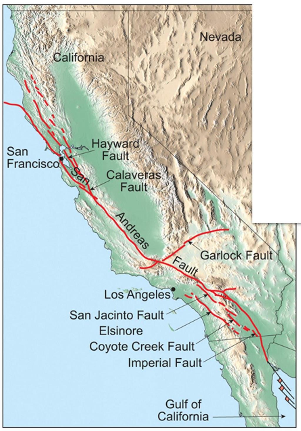
3 Strike-slips San Andreas fault Piqiang fault
4 Fundamental principle of geomorphology: Change in landscape caused by change in landscape process (e.g. increased slope on alluvial fan -? tectonic or sedimentary process?) Tectonic geomorphology - looks for morphological anomalies surfaces warped, tilted, uplifted, fractured Some features indicate the presence of a fault, but say little about activity or type of movements: vegetation alignments, springs, fault scarps, other lineaments

 - effective barier Gilman Hot Springs, San")
5 Linear springs All Fault Types Have Potential to Disrupt Groundwater Flow (narušení toku podzemních vod) Springs fault gouge (tektonický jíl) - effective barier Gilman Hot Springs, San Jacinto Valley
 San Andreas")

6 Vegetation Lineaments (arid areas) San Andreas Fault -Thousand Palms Oasis, Indio Hills, California

7 Scarps (zlomové svahy) all fault types, all scales Northward across Coyote Creek Fault, San Jacinto Fault Zone
 A young")

8 Scarp on strike-slip (oblique slip) A young scarp!! Carboneras fault, Spain Coyote Mts, Elsinore fault, CA


9 Scarps on normal fault Krupnik fault, Bulgary, 1904 M=7,8
10 Scarps on thrust/reverse fault (přesmyk) Chichi earthquake 1999, Taiwan


11

12

13 Active or Inactive? Differential weathering along inactive faults can produce features that resemble features produced by active faults Vegetation lineaments Linear valleys - Scarps (výrazné terénní stupně) Fault Scarps (zlomový svah) Complex fault scarp (složený zlomový svah) Fault-Line Scarps (svah na zlomové čáře)
 - scarps in alluvium, deflected drainages, sags, shutter ridges, side-hill benches A general rule is that active faults produce alluvium so they bury")
14 Some geomorphic features clearly indicate young activity (usually Holocene to late Quaternary) If it is expressed in the geomorphology, it is likely active (unless you can demonstrate that the features are totally erosional in nature) - scarps in alluvium, deflected drainages, sags, shutter ridges, side-hill benches A general rule is that active faults produce alluvium so they bury themselves, so locally, the evidence for activity may be obscured along some portions of the fault Christchurch EQ , M = 6.3, NZ - unknown fault, uplift of Southern Alps 10mm/year =high sedimentation, sediments obscure the fault trace

15 Active Strike-Slip Fault Geomorphology Burbank and Anderson, 2001
 All offsets are deflections, but")
16 Effects on Stream Channels Offsets Implies a previously straight, now-curved channel as a result of displacement the bend in the channel must agree with the sense of slip! Deflections The curve in the channel can be with or against the sense of slip Result of drainage capture (water will take the easiest path downhill, alluvial fans) All offsets are deflections, but not all deflections are offsets!

17 Offset channels Pitman Canyon ~ 46 m offsets


18 San Andreas Fault, Carrizo plain, CA

19 Wallace creek


20

21 Offset/Deflected channels Carizzo plain
22 Superstition Hills fault


23 Coyote Mts 0 10 km Coyote Mts 0 40 km

24 extension sag pond beheaded channels 15m offset valley side Elsinore fault, Coyote Mts, CA

25 beheaded channels 5-8m cumulative slip 15m

26 offset and beheaded channel fault 2m

27 Offset alluvial fans Elsinore 0 fault, 500 Coyote m Mts, CA


28 Alverson canyon, offset valley side 0 40 m

29 0 50m

30 offset channels and bars

31 offset channel bars


32 offset alluvial fan

33 offset alluvial fan 150m Different lithology tells us about the amount of offset

34

35 Laguna Salada fault, 2010, M= 7.2 El Mayor offset channel


36 offset channel offset valley side

37 Kunlun fault, Tibet, 2001 M = 7.8

38 San Jacinto Fault, Southern California Offset Channel

39 sag sag piercing/matching points Offset channel margin
 blocking drainage Clark strand of the San")
40 Shutter Ridge Ridge moved and blocked the drainage Drainage Shutter Ridge(s) blocking drainage Clark strand of the San Jacinto

41 Hector Mine Rupture, 1999
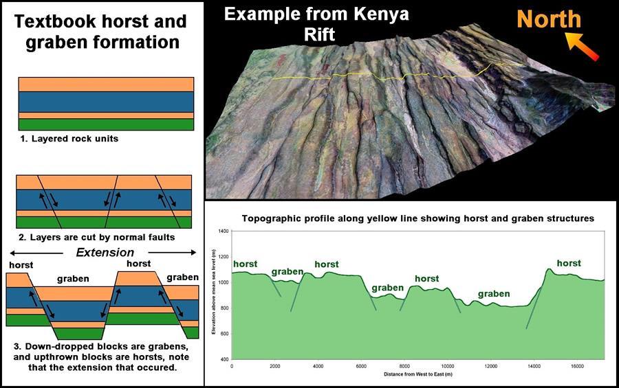
")
42 San Jacinto Fault, Southern California Shutter Ridge(s)

43 Linear valleys Linear valleys - related to faulting or just fault-line eroding crushed fault zone rocks
44 Transtension/Transpression Both occur at all scales! Local to regional features Controlled by bends in SS fault (local), or overall convergence/divergence along a SS fault (regional) Transtension Simultaneous occurrence of strike-slip faulting and extension Transpression Simultaneous occurrence of strike-slip faulting and shortening
45 Transtension Component of divergence along SS fault (strike-slip) Right steps in Dextral (pravostranný) SS fault Left steps in Sinistral (levostranný) SS fault Opening causes a sag, or pull-apart basin


46 Sag Ponds San Andreas Topographic depression produced by extensional bends or stepovers along a strike-slip fault. It may or may not contain water year-round. Synonymous with pull-apart basin.

47 Transpression Component of convergence along SS fault Left step in Dextral SS fault Right step in Sinistral SS Fault Right-step causes a space problem, and a pressure ridge is formed

48 Pressure ridge A topographic ridge produced by compressional bends or stepovers along a strike-slip fault Small pressure ridge along SAF in Cholame Valley


49 Dragon s Back Pressure Ridge System along the San Andreas


50 Pressure ridge Thousands Palms Indio Hills, San Andreas fault Denali fault, 1964, M=8,5


51 Mole track structure Material is extruded along the fault by pressure Kunlun fault, Tibet, 2001 M = 7.8


52 SAF, San Francisco 1906, M = 7.9 Denali fault, Alaska


53 Side-Hill Benches/Valleys Parallel faults, Kresna Gorge, Bulgary


54 Slope inflection along San Andreas Fault Flat step on the slope


55 Geomorphology of Extensional Faulting: normal fault Zanjan. Iran
 Crustal")
 Down-faulted block")
56 Displacement accommodated in normal faults Single, Parallel synthetic, Antithetic Extensional Faulting Primary normal fault (60-70) Crustal penetrating fault Often has km of displacement Separates linear mountain range from adjacent basin Up-faulted block (horst) Down-faulted block (graben)


57 Crustal extension and normal faults related to the most remarkable topography at regional scale Rifts valleys rift elevated heatflow, vertical compression, horizontal extension


58 East African Rift Valley active divergence, rift numerous of normal faults East African rift in 20 mil years


59 Hayli Gubbi, shield volcano, crater inside caldera, Afar region, Ethiopia Normal faults disecting the volcanos, Afar


60 Rift activity 2009 Massive fissure splits open in the Ethiopian Desert


61 Escarpments Rift Valley - Tanzania Main Ethiopian Rift Valley They has been formed during millions years
62


63 Iceland Rift Valley ridge represents submarine segments of the mid-ocean ridge Iceland - shaded area shows the Icelandic Basalt Plateau, red points the migration of the hot spot and orange lines are the rifts, both active and inactive.


64 Geological map of Iceland - volcanic systems and volcanic zones and the division of the island into formations. Each volcano with the typical lifetime of my. Around 30 active volcanic systems in Iceland. Rift valley, Thingvellir national park, Iceland


65 Ocean ridge basaltic oceanic crust Mid-Atlantic oceanic ridge


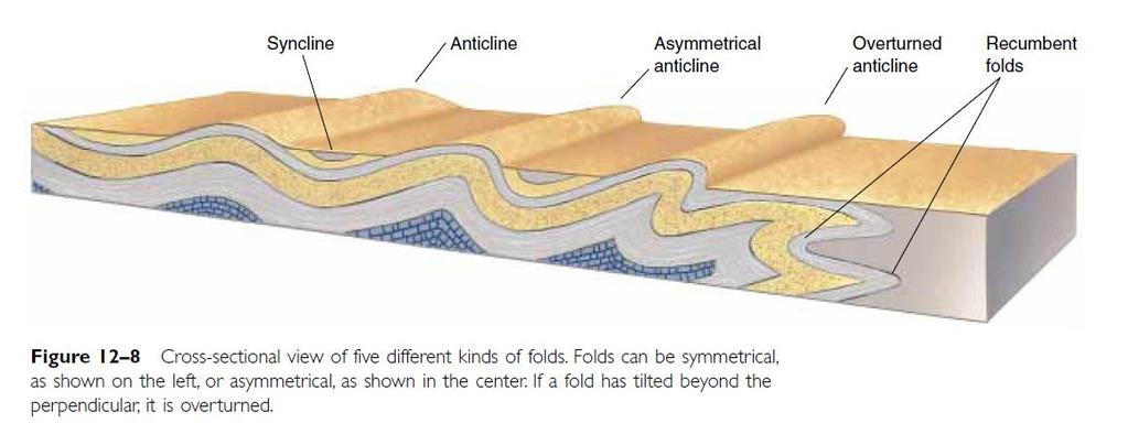
66 broad extensional faulting Basin and Range topography Basin and Range Province extension and thinning of the lithosphere, listric faults, grabens, horsts elevated heat flow, geothermal energy From Sierra Nevada to Wasatch Mts 800 km

67 Local scale normal faults Fault trace of normal faults tends to be short km The Wasatch fault, forms the eastern boundary of the Basin and Range geologic province frontal fault are up to 400 km long, composed of separate faults or segments km long, average of 40 km, each of which can independently produce earthquakes as powerful as local magnitude 7.5


68 Linear mountain fronts Wasatch Mts Linear mountaint front - repeated earthquakes The Wasatch Mountains have been uplifted and tilted to the east by movement of the fault. The average rate of uplift along the fault over its history is approximately 1 mm per year.

69 Scarp on the southern part of the Nephi strand of the Wasatch fault:

 in")
70 Wasatch fault Multiple fault scarps (marked by arrows) cut across 16,000 to 18,000-year-old glacial moraines in Salt Lake County. Some of the scarps are 30 to 40m high, indicating they were formed by repeated large earthquakes (possibly as many as seven to ten events) in the past 18,000 years

71 Triangular (trapezoidal) facets - dissected mountain front by rivers, setries of facets - flatirons un-named fault in California, SE from Panamint Valley

72


73 Subsided blocks San Gorgonio Pass Narrow block subsided between two ridges uplifted by strands of San Andrea Fault sags and ridges by uneven blocks uplift
74 Reverse Faulting, Folding and Uplifting Crustal shortening + thickening Crustal shortening is the reduction of the size of the Earth's crust through convergent plate boundary (compression)


75 Crustal Shortening Implications : - Reverse/Thrust Fault - Fold - Uplift

76 Reverse Thrust/overthrust Fault Reverse Fault : > 45 0 Menší slip větší reliéf, ale menší oblast postižena <45 0 Video!
 Thrust faults often associated with fold - in fold-and-thrust belts - some of the thrusts and reverse fault may break the")

77 Thrust faults associated with subduction produce a variety of landforms - uplifted coastal terraces, anticlinal hills (upwarped) and synclinal lowlands (downwarped) Thrust faults often associated with fold - in fold-and-thrust belts - some of the thrusts and reverse fault may break the surface or they remain hidden in the core of anticline blind reverse fault Asymmetric fault-propagation fold developed over a décollement Reverse faults- closely related to folds Rate of lateral propagation of faults and fold may be several times higher than vertical slip rate of the fault
78 Landforms associated with reverse faulting steep mountain fronts, fault scarps, fold scarps, extensional features, and landslides
,b),c ) hanging-wall folding d)")
79 1980 EL Asnam M=7.3, Algeria fold-and-thrust belt 3-6 m slip on reverse fault at the depth, surface rupture - 2m mostly anticlinal uplift of 5m seismic folding a),b),c ) hanging-wall folding d) extensional features produced by component of left-lateral shear c) tension fractures a) elongated en echelon depressions b) footwall folding and flexural-slip faulting

80 Graph of surface uplift produced by 1980 El Asnam EQ. The fold was produced by repetaed earthuqakes Bolcked river formation of a lake with deposition of 0.4 m


81 Fault scarps
82
83 Fold

84

85 Thompson and Turk, 1998
Tectonic geomorphology
 Tectonic geomorphology studies processes and landforms controlled by tectonics Change in landscape caused by change in landscape process Look for morphological anomalies surfaces warped, tilted, uplifted,
Earth Science, (Tarbuck/Lutgens) Chapter 10: Mountain Building
 Chapter 10: Mountain Building") Earth Science, (Tarbuck/Lutgens) Chapter 10: Mountain Building 1) A(n) fault has little or no vertical movements of the two blocks. A) stick slip B) oblique slip C) strike slip D) dip slip 2) In a(n) fault,
Earth Science, (Tarbuck/Lutgens) Chapter 10: Mountain Building 1) A(n) fault has little or no vertical movements of the two blocks. A) stick slip B) oblique slip C) strike slip D) dip slip 2) In a(n) fault,
Chapter 15 Structures
 Chapter 15 Structures Plummer/McGeary/Carlson (c) The McGraw-Hill Companies, Inc. TECTONIC FORCES AT WORK Stress & Strain Stress Strain Compressive stress Shortening strain Tensional stress stretching
Crustal Deformation. Earth Systems 3209
 Crustal Deformation Earth Systems 3209 Crustal Deformation pg. 415 Refers to all changes in the original form and/or size of a rock body. May also produce changes in the location and orientation of rocks.
Geomorphology Final Exam Study Guide
 Geomorphology Final Exam Study Guide Geologic Structures STRUCTURAL GEOLOGY concerned with shapes, arrangement, interrelationships of bedrock units & endogenic (within) forces that cause them. Tectonic
Description of faults
 GLG310 Structural Geology Description of faults Horizontal stretch Crustal thickness Regional elevation Regional character Issues Normal Thrust/reverse Strike-slip >1 1 in one direction and < 1 in
Continental Landscapes
 Continental Landscapes Landscape influenced by tectonics, climate & differential weathering Most landforms developed within the last 2 million years System moves toward an equilibrium Continental Landscapes
Directed Reading. Section: How Mountains Form MOUNTAIN RANGES AND SYSTEMS. Skills Worksheet
 Skills Worksheet Directed Reading Section: How Mountains Form 1. How high is Mount Everest? a. about 1980 km above sea level b. more than 8 km below sea level c. more than 8 km above sea level d. more
Earthquakes. Earthquakes are caused by a sudden release of energy
 Earthquakes Earthquakes are caused by a sudden release of energy The amount of energy released determines the magnitude of the earthquake Seismic waves carry the energy away from its origin Fig. 18.1 Origin
Description of faults
 GLG310 Structural Geology Description of faults Horizontal stretch Crustal thickness Regional elevation Regional character Issues Normal Thrust/reverse Strike-slip >1 1 in one direction and < 1 in
Chapter 16. Mountain Building. Mountain Building. Mountains and Plate Tectonics. what s the connection?
 Chapter 16 Mountains and Plate Tectonics what s the connection? Mountain Building Most crustal deformation occurs along plate margins. S.2 Active Margin Passive Margin Mountain Building Factors Affecting
Mountains and Mountain Building: Chapter 11
 Mountains and Mountain Building: Chapter 11 Objectives: 1)Explain how some of Earth s major mountain belts formed 2) Compare and contrast active and passive continental margins 3) Explain how compression,
Lecture # 6. Geological Structures
 1 Lecture # 6 Geological Structures ( Folds, Faults and Joints) Instructor: Dr. Attaullah Shah Department of Civil Engineering Swedish College of Engineering and Technology-Wah Cantt. 2 The wavy undulations
Crustal Deformation Earth - Chapter Pearson Education, Inc.
 Crustal Deformation Earth - Chapter 10 Structural Geology Structural geologists study the architecture and processes responsible for deformation of Earth s crust. A working knowledge of rock structures
December 21, Chapter 11 mountain building E.notebook. Feb 19 8:19 AM. Feb 19 9:28 AM
 Mountains form along convergent plate boundaries. Typically (usually) if you look at a mountain range, you know that it is at a plate boundary (active continental margin) or has been some time in the past
Geologic Structures. Changes in the shape and/or orientation of rocks in response to applied stress
 Geologic Structures Changes in the shape and/or orientation of rocks in response to applied stress Figure 15.19 Can be as big as a breadbox Or much bigger than a breadbox Three basic types Fractures >>>
Section 10.1 The Nature of Volcanic Eruptions This section discusses volcanic eruptions, types of volcanoes, and other volcanic landforms.
 Chapter 10 Section 10.1 The Nature of Volcanic Eruptions This section discusses volcanic eruptions, types of volcanoes, and other volcanic landforms. Reading Strategy Previewing Before you read the section,
CRUSTAL DEFORMATION. Chapter 10
 CRUSTAL DEFORMATION and dgeologic Structures t Chapter 10 Deformation Df Deformation involves: Stress the amount of force applied to a given area. Types of Stress: Confining Stress stress applied equally
How to Build a Mountain and other Geologic Structures. But first a short review
 How to Build a Mountain and other Geologic Structures But first a short review Where do we see deep earthquakes? What is happening there? What can happen at a plate boundary? 1. Plates can move apart
Earthquake Tectonics and Hazards on the Continents June Recognizing and characterizing strike-slip faults and earthquakes in USA
 2464-4 Earthquake Tectonics and Hazards on the Continents 17-28 June 2013 Recognizing and characterizing strike-slip faults and earthquakes in USA S. G. Wesnousky Univ. of Nevada USA Strike-slip Faults
Plate Tectonics - Demonstration
 Name: Reference: Prof. Larry Braile - Educational Resources Copyright 2000. L. Braile. Permission granted for reproduction for non-commercial uses. http://web.ics.purdue.edu/~braile/indexlinks/educ.htm
KEY CHAPTER 12 TAKE-HOME QUIZ INTERNAL STRUCTURES AND PROCESSES Score Part B = / 55 PART B
 GEOLOGY 12 KEY CHAPTER 12 TAKE-HOME QUIZ INTERNAL STRUCTURES AND PROCESSES Score Part B = / 55 PART B CHAPTER 12 Isostacy and Structural Geology 1. Using the terms below, label the following diagrams and
Copyright McGraw-Hill Education. All rights reserved. No reproduction or distribution without the prior written consent of McGraw-Hill Education
 Copyright McGraw-Hill Education. All rights reserved. No reproduction or distribution without the prior written consent of McGraw-Hill Education Tibetan Plateau and Himalaya -southern Asia 11.00.a VE 10X
Earth s Many Landforms. Earth s Many Landforms. Earth s Many Landforms. Crustal Deformation. Crustal Deformation 10/22/2014
 Hewitt/Lyons/Suchocki/Yeh Conceptual Integrated Science Chapter 24 EARTH S SURFACE LAND AND WATER Earth s Many Landforms Earth consists of seven continents: Africa, Antarctica, Asia, Australia, Europe,
How mountains are made. We will talk about valleys (erosion and weathering later)
") How mountains are made We will talk about valleys (erosion and weathering later) http://www.ilike2learn.com/ilike2learn/mountainmaps/mountainranges.html Continent-continent plate convergence Less dense,
How mountains are made We will talk about valleys (erosion and weathering later) http://www.ilike2learn.com/ilike2learn/mountainmaps/mountainranges.html Continent-continent plate convergence Less dense,
UNIT 3 GEOLOGY VOCABULARY FLASHCARDS THESE KEY VOCABULARY WORDS AND PHRASES APPEAR ON THE UNIT 3 CBA
 UNIT 3 GEOLOGY VOCABULARY FLASHCARDS THESE KEY VOCABULARY WORDS AND PHRASES APPEAR ON THE UNIT 3 CBA A map that shows Earth s Topographic Map surface topography, which is Earth s shape and features Contour
Chapter 4 Section 3, 4. Deforming the Earth s Crust
 Chapter 4 Section 3, 4 Deforming the Earth s Crust Deformation The process by which the shape of a rock changes because of stress Stress The amount of force per unit area on a given material Compression
What Causes Rock to Deform?
 Crustal Deformation Earth, Chapter 10 Chapter 10 Crustal Deformation What Causes Rock to Deform? Deformation is a general term that refers to all changes in the shape or position of a rock body in response
Chapter 10: Volcanoes and Other Igneous Activity Section 1: The Nature of Volcanic Eruptions I. Factors Affecting Eruptions Group # Main Idea:
 Chapter 10: Volcanoes and Other Igneous Activity Section 1: The Nature of Volcanic Eruptions I. Factors Affecting Eruptions Group # A. Viscosity Group # B. Dissolved Gases Group # II. Volcanic Material
Crustal Deformation. (Building Earth s Surface, Part 1) Science 330 Summer Mapping geologic structures
 Science 330 Summer Mapping geologic structures") Crustal Deformation (Building Earth s Surface, Part 1) Science 330 Summer 2005 Mapping geologic structures When conducting a study of a region, a geologist identifies and describes the dominant rock structures
Crustal Deformation (Building Earth s Surface, Part 1) Science 330 Summer 2005 Mapping geologic structures When conducting a study of a region, a geologist identifies and describes the dominant rock structures
Not For Web Reproduction. New Topic: TECTONIC GEOMORPHOLOGY. Tectonic Geomorphology vs. Structural Geomorphology
 New Topic: TECTONIC GEOMORPHOLOGY Tectonic Geomorphology vs. Structural Geomorphology Late Cenozoic Tectonic Movement vs. Late Cenozoic Erosion of Older Structures Geologic Time Scale Not For Web Reproduction
Deformation of Rocks. Orientation of Deformed Rocks
 Deformation of Rocks Folds and faults are geologic structures caused by deformation. Structural geology is the study of the deformation of rocks and its effects. Fig. 7.1 Orientation of Deformed Rocks
Unit 4 Lesson 7 Mountain Building
 Indiana Standards 7.2.4 Explain how convection currents in the mantle cause lithospheric plates to move causing fast changes like earthquakes and volcanic eruptions, and slow changes like creation of mountains
Essentials of Geology, 11e
 Essentials of Geology, 11e Crustal Deformation and Mountain Building Chapter 17 Instructor Jennifer Barson Spokane Falls Community College Geology 101 Stanley Hatfield Southwestern Illinois College Jennifer
USU 1360 TECTONICS / PROCESSES
 USU 1360 TECTONICS / PROCESSES Observe the world map and each enlargement Pacific Northwest Tibet South America Japan 03.00.a1 South Atlantic Arabian Peninsula Observe features near the Pacific Northwest
11.1 Rock Deformation
 Tarbuck Lutgens Mountain Building 11.1 Rock Deformation Factors Affecting Deformation Factors that influence the strength of a rock and how it will deform include temperature, confining pressure, rock
8 th Grade Science Plate Tectonics and Topography Review
 8 th Grade Science Plate Tectonics and Topography Review #1 Scientists believe that the land masses of Earth were once joined together as one supercontinent called. A: Australia B: Wegner C: Pangaea D:
Chapter. Mountain Building
 Chapter Mountain Building 11.1 Rock Deformation Factors Affecting Deformation Factors that influence the strength of a rock and how it will deform include temperature, confining pressure, rock type, and
mountain rivers fixed channel boundaries (bedrock banks and bed) high transport capacity low storage input output
 high transport capacity low storage input output") mountain rivers fixed channel boundaries (bedrock banks and bed) high transport capacity low storage input output strong interaction between streams & hillslopes Sediment Budgets for Mountain Rivers Little
mountain rivers fixed channel boundaries (bedrock banks and bed) high transport capacity low storage input output strong interaction between streams & hillslopes Sediment Budgets for Mountain Rivers Little
Movement of the Earth s Crust: Formation of: Mountain s Plateau's and Dome s
 Movement of the Earth s Crust: Formation of: Mountain s Plateau's and Dome s References Information taken from several places including Prentice Hall Earth Science: @ http://www.eram.k12.ny.us/education/components/docmgr/default.php?sectiondetaili
Strike-Slip Faults. ! Fault motion is parallel to the strike of the fault.
 Strike-Slip Faults! Fault motion is parallel to the strike of the fault.! Usually vertical, no hanging-wall/footwall blocks.! Classified by the relative sense of motion. " Right lateral opposite block
Section 3 Deforming Earth s Crust
 Section 3 Deforming Earth s Crust Key Concept Tectonic plate motions deform Earth s crust. Deformation causes rock layers to bend and break and causes mountains to form. What You Will Learn Stress is placed
Learning Objectives (LO) What we ll learn today:!
 What we ll learn today:!") Learning Objectives (LO) Lecture 13: Mountain Building Read: Chapter 10 Homework #11 due Tuesday 12pm What we ll learn today:! 1. Define the types of stress that are present in the crust! 2. Define the
Learning Objectives (LO) Lecture 13: Mountain Building Read: Chapter 10 Homework #11 due Tuesday 12pm What we ll learn today:! 1. Define the types of stress that are present in the crust! 2. Define the
UNIT 10 MOUNTAIN BUILDING AND EVOLUTION OF CONTINENTS
 UNIT 10 MOUNTAIN BUILDING AND EVOLUTION OF CONTINENTS ROCK DEFORMATION Tectonic forces exert different types of stress on rocks in different geologic environments. STRESS The first, called confining stress
FINAL EXAM Crustal Deformation CONVERGE DIVERGENT PLATES MANTLE PLUMES FLUX BASALTIC GRANITIC
 Crustal Deformation Reading: Chapter 10 Pages 283-304 Review Questions 4, 6, 7, 10, 12, 15, 18, 20 FINAL EXAM NOON TO 2 PM, TUESDAY DEC. 5 HERE: Natural Science 101 BRING A SCAN TRON TURN IN YOUR REVIEW
How to Build a Mountain and other Geologic Structures. But first, questions
 How to Build a Mountain and other Geologic Structures But first, questions Questions your students might ask How were Montana s mountains formed? How old are the mountains? What are the different ways
Basin & Range / Mojave Desert
 Basin & Range / Mojave Desert Basin & Range vs. Great Basin 1 2/20/2016 An overview of the last horst Basin and Range / Mojave Desert Summary: Granitic, volcanic, marine sedimentary, non marine sedimentary,
Forces in Earth s Crust
 Forces in Earth s Crust (pages 180 186) Types of Stress (page 181) Key Concept: Tension, compression, and shearing work over millions of years to change the shape and volume of rock. When Earth s plates
Active Tectonics. Earthquakes, Uplift, and Landscape. Edward A. Keller University of California, Santa Barbara
 Prentice Hall Earth Science Series SUB Gottingen 214 80416X, im ^, 2002 A 7883 lllllllilwii Active Tectonics Earthquakes, Uplift, and Landscape Second Edition V Edward A. Keller University of California,
24. Ocean Basins p
 24. Ocean Basins p. 350-372 Background The majority of the planet is covered by ocean- about %. So the majority of the Earth s crust is. This crust is hidden from view beneath the water so it is not as
Unit 4 Lesson 3 Mountain Building. Copyright Houghton Mifflin Harcourt Publishing Company
 Stressed Out How can tectonic plate motion cause deformation? The movement of tectonic plates causes stress on rock structures. Stress is the amount of force per unit area that is placed on an object.
Topic 12: Dynamic Earth Pracatice
 Name: Topic 12: Dynamic Earth Pracatice 1. Earth s outer core is best inferred to be A) liquid, with an average density of approximately 4 g/cm 3 B) liquid, with an average density of approximately 11
PHYSICAL GEOGRAPHY General Information
 PHYSICAL GEOGRAPHY General Information By understanding the environment we can understand why one place is different or the same as another. See handout Geomorphology Geo --Land morph --Change ology --Study
Plate Tectonics. entirely rock both and rock
 Plate Tectonics I. Tectonics A. Tectonic Forces are forces generated from within Earth causing rock to become. B. 1. The study of the origin and arrangement of Earth surface including mountain belts, continents,
Mountains are then built by deforming crust: Deformation & Mountain Building. Mountains form where stresses are high!
 Deformation & Mountain Building Where are mountains located? Deformation and Folding Mountain building Mountains form where stresses are high! Mountains form at all three types of plate boundaries where
Staple this part to part one of lab 6 and turn in. Lab 6, part two: Structural geology (analysis)
") Geology 101 Staple this part to part one of lab 6 and turn in Lab 6, part two: Structural geology (analysis) Recall that the objective of this lab is to describe the geologic structures of Cougar Mountain
Geology 101 Staple this part to part one of lab 6 and turn in Lab 6, part two: Structural geology (analysis) Recall that the objective of this lab is to describe the geologic structures of Cougar Mountain
Plate Boundaries & Resulting Landforms
 Plate Boundaries & Resulting Landforms Divergent Plate Boundaries (plates being pulled apart) Type: oceanic plates Description: rising magma gently lifts the crust creating a ridge. The flow of convection
4 Deforming the Earth s Crust
 CHAPTER 7 4 Deforming the Earth s Crust SECTION Plate Tectonics BEFORE YOU READ After you read this section, you should be able to answer these questions: What happens when rock is placed under stress?
Plate Tectonics. I. The Discovery of Plate Tectonics II. A Mosaic of Plates III. Types of Plate Boundaries IV. How Plates Move
 Plate Tectonics I. The Discovery of Plate Tectonics II. A Mosaic of Plates III. Types of Plate Boundaries IV. How Plates Move I. The Discovery of Plate Tectonics A. Continental Drift (Alfred Wegener) Proposed
Forces That Shape Earth. How do continents move? What forces can change rocks? How does plate motion affect the rock cycle?
 Forces That Shape Earth How do continents move? What forces can change rocks? How does plate motion affect the rock cycle? Plate Motion Mountain ranges are produced by plate tectonics. The theory of plate
1. occurs when the oceanic crust slides under the continental crust.
 1. occurs when the oceanic crust slides under the continental crust. 2. What type of stress is shown? 3. Where two plates slide past one another is called a boundary. 4. What type of stress is shown? 5.
Crags, Cracks, and Crumples: Crustal Deformation and Mountain Building
 Crags, Cracks, and Crumples: Crustal Deformation and Mountain Building Updated by: Rick Oches, Professor of Geology & Environmental Sciences Bentley University Waltham, Massachusetts Based on slides prepared
Lab 7: STRUCTURAL GEOLOGY FOLDS AND FAULTS
 Lab 7: STRUCTURAL GEOLOGY FOLDS AND FAULTS This set of labs will focus on the structures that result from deformation in earth s crust, namely folds and faults. By the end of these labs you should be able
Plate Tectonics Notes
 Plate Tectonics Notes Last 30 Days Earthquakes Physical Features Last 30 Days Earthquakes with Plate Boundaries Earth s Structure Earth s Layers Core: Inner Core: Center of the earth, solid ball of metal
Geology 300, Physical Geology Spring 2019 Quiz Ch 19, Plate Tectonics Name
 Geology 300, Physical Geology Spring 2019 Quiz Ch 19, Plate Tectonics Name MULTIPLE CHOICE. Choose the one alternative that best completes the statement or answers the question. 1) The portion of a fracture
Shape Earth. Plate Boundaries. Building. Building
 Chapter Introduction Lesson 1 Lesson 2 Lesson 3 Lesson 4 Chapter Wrap-Up Forces That Shape Earth Landforms at Plate Boundaries Mountain Building Continent Building How is Earth s surface shaped by plate
Lecture Outlines PowerPoint. Chapter 10 Earth Science, 12e Tarbuck/Lutgens
 Lecture Outlines PowerPoint Chapter 10 Earth Science, 12e Tarbuck/Lutgens 2009 Pearson Prentice Hall This work is protected by United States copyright laws and is provided solely for the use of instructors
A Classification of Forces Affecting the Landforms
 Landforms There are many forms of land on the surface of the earth. Continents, oceans, mountains, plateaus, valleys, deltas, etc., are some of the examples of landforms. Landforms can be divided into
TAKE HOME EXAM 8R - Geology
 Name Period Date TAKE HOME EXAM 8R - Geology PART 1 - Multiple Choice 1. A volcanic cone made up of alternating layers of lava and rock particles is a cone. a. cinder b. lava c. shield d. composite 2.
Stress and Strain. Stress is a force per unit area. Strain is a change in size or shape in response to stress
 Geologic Structures Geologic structures are dynamically-produced patterns or arrangements of rock or sediment that result from, and give information about, forces within the Earth Produced as rocks change
A) B) C) D) 4. Which diagram below best represents the pattern of magnetic orientation in the seafloor on the west (left) side of the ocean ridge?
 B) C) D) 4. Which diagram below best represents the pattern of magnetic orientation in the seafloor on the west (left) side of the ocean ridge?") 1. Crustal formation, which may cause the widening of an ocean, is most likely occurring at the boundary between the A) African Plate and the Eurasian Plate B) Pacific Plate and the Philippine Plate C)
1. Crustal formation, which may cause the widening of an ocean, is most likely occurring at the boundary between the A) African Plate and the Eurasian Plate B) Pacific Plate and the Philippine Plate C)
COSMORPHOLOGY - May 2009
 Name COSMORPHOLOGY - May 2009 Geologic landforms Purpose: By studying aerial photographs you will learn to identify different kinds of geologic features based on their different morphologies and learn
Earth s Continents and Seafloors. GEOL100 Physical Geology Ray Rector - Instructor
 Earth s Continents and Seafloors GEOL100 Physical Geology Ray Rector - Instructor OCEAN BASINS and CONTINENTAL PLATFORMS Key Concepts I. Earth s rocky surface covered by of two types of crust Dense, thin,
Chapter 10: Deformation and Mountain Building. Fig. 10.1
 Chapter 10: Deformation and Mountain Building Fig. 10.1 OBJECTIVES Describe the processes of rock deformation and compare and contrast ductile and brittle behavior in rocks. Explain how strike and dip
Section 2: How Mountains Form
 Section 2: How Mountains Form Preview Objectives Mountain Ranges and Systems Plate Tectonics and Mountains Types of Mountains Objectives Identify the types of plate collisions that form mountains. Identify
Before Plate Tectonics: Theory of Continental Drift
 Before Plate Tectonics: Theory of Continental Drift Predecessor to modern plate tectonics Shape and fit of the continents was the initial evidence Snider-Pelligrini (1858) Taylor (1908) Wegner (1915) Fig.
Plate Tectonics. Structure of the Earth
 Plate Tectonics Structure of the Earth The Earth can be considered as being made up of a series of concentric spheres, each made up of materials that differ in terms of composition and mechanical properties.
Landscape evolution. An Anthropic landscape is the landscape modified by humans for their activities and life
 Landforms Landscape evolution A Natural landscape is the original landscape that exists before it is acted upon by human culture. An Anthropic landscape is the landscape modified by humans for their activities
Overview of the Seismic Source Characterization for the Palo Verde Nuclear Generating Station
 Overview of the Seismic Source Characterization for the Palo Verde Nuclear Generating Station Scott Lindvall SSC TI Team Lead Palo Verde SSC SSHAC Level 3 Project Tuesday, March 19, 2013 1 Questions from
Lecture Marine Provinces
 Lecture Marine Provinces Measuring bathymetry Ocean depths and topography of ocean floor Sounding Rope/wire with heavy weight Known as lead lining Echo sounding Reflection of sound signals 1925 German
4 Deforming the Earth s Crust
 CHAPTER 7 4 Deforming the Earth s Crust SECTION Plate Tectonics BEFORE YOU READ After you read this section, you should be able to answer these questions: What happens when rock is placed under stress?
Answers: Internal Processes and Structures (Isostasy)
") Answers: Internal Processes and Structures (Isostasy) 1. Analyse the adjustment of the crust to changes in loads associated with volcanism, mountain building, erosion, and glaciation by using the concept
Answers: Internal Processes and Structures (Isostasy) 1. Analyse the adjustment of the crust to changes in loads associated with volcanism, mountain building, erosion, and glaciation by using the concept
Bathymetry Measures the vertical distance from the ocean surface to mountains, valleys, plains, and other sea floor features
 1 2 3 4 5 6 7 8 9 10 11 CHAPTER 3 Marine Provinces Chapter Overview The study of bathymetry determines ocean depths and ocean floor topography. Echo sounding and satellites are efficient bathymetric tools.
Layers of the Earth Date: SWABT: Identify and describe the layers of the Earth and their characteristics
 Layers of the Earth SWABT: Identify and describe the layers of the Earth and their characteristics CRUST Composition: Thickness: State of Matter: : Mostly Basalt : Mostly Granite : Crust and Upper Mantle
Introduction Faults blind attitude strike dip
 Chapter 5 Faults by G.H. Girty, Department of Geological Sciences, San Diego State University Page 1 Introduction Faults are surfaces across which Earth material has lost cohesion and across which there
Topography the natural and human features of the Earth s surface. ie. Surface features need to understand difference between relief and elevation
 Chapter 1 Landform Patterns and Processes Highlighted script will not be assessed Topography the natural and human features of the Earth s surface. ie. Surface features need to understand difference between
Forces in the Earth s crust
 EARTHQUAKES Forces in the Earth s crust How does stress in the crust change Earth s surface? Where are faults usually found, and why do they form? What land features result from the forces of plate movement?
12. The diagram below shows the collision of an oceanic plate and a continental plate.
 Review 1. Base your answer to the following question on the cross section below, which shows the boundary between two lithospheric plates. Point X is a location in the continental lithosphere. The depth
Forces in Earth s Crust
 Forces in Earth s Crust This section explains how stresses in Earth s crust cause breaks, or faults, in the crust. The section also explains how faults and folds in Earth s crust form mountains. Use Target
A physical feature of the Earth s surface
 Earth s Landforms A physical feature of the Earth s surface A physical feature of the Earth s surface LANDFORM Highest of Earth s physical features Highest of Earth s physical features MOUNTAIN Low area
Chapter 7 Plate Tectonics. Plate tectonics accounts for important features of Earth s surface and major geologic events.
 Chapter 7 Plate Tectonics Plate tectonics accounts for important features of Earth s surface and major geologic events. 7-2 Alfred Wegener s Hypothesis of Continental Drift (1915) He noticed that the continents
GEOLOGY MEDIA SUITE Chapter 13
 UNDERSTANDING EARTH, SIXTH EDITION GROTZINGER JORDAN GEOLOGY MEDIA SUITE Chapter 13 Earthquakes 2010 W.H. Freeman and Company Three different types of seismic waves are recorded by seismographs Key Figure
Chapter Overview. Bathymetry. Measuring Bathymetry. Measuring Bathymetry
 CHAPTER 3 Marine Provinces Chapter Overview The study of bathymetry determines ocean depths and ocean floor topography. Echo sounding and satellites are efficient bathymetric tools. Most ocean floor features
3. PLATE TECTONICS LAST NAME (ALL IN CAPS): FIRST NAME: PLATES
: FIRST NAME: PLATES") LAST NAME (ALL IN CAPS): FIRST NAME: PLATES 3. PLATE TECTONICS The outer layers of the Earth are divided into the lithosphere and asthenosphere. The division is based on differences in mechanical properties
LAST NAME (ALL IN CAPS): FIRST NAME: PLATES 3. PLATE TECTONICS The outer layers of the Earth are divided into the lithosphere and asthenosphere. The division is based on differences in mechanical properties
on the earthquake's strength. The Richter scale is a rating of an earthquake s magnitude based on the size of the
 Earthquakes and Seismic Waves An earthquake is the shaking and trembling that results from the movement of rock beneath Earth's surface. The point beneath Earth s surface where rock under stress breaks
Geologic Landforms Seen on Aerial Photos Instructor Notes
 1.5 hours Exercise Two Geologic Landforms Instructor Notes Suggested Correlation of Topics Geomorphology, gradation, impact cratering, tectonism, volcanism, photography Purpose The objective of this exercise
Earthquakes. Chapter Test A. Multiple Choice. Write the letter of the correct answer on the line at the left.
 Earthquakes Chapter Test A Multiple Choice Write the letter of the correct answer on the line at the left. 1. Stress that pushes a mass of rock in two opposite directions is called a. shearing. b. tension.
Terrain Units PALEOGEOGRAPHY: LANDFORM CREATION. Present Geology of NYS. Detailed Geologic Map of NYS
 NYS TOPOGRAPHY Why so? PALEOGEOGRAPHY: LANDFORM CREATION Prof. Anthony Grande AFG 014 Present Geology of NYS Detailed Geologic Map of NYS Generalized Geology Detailed Geology Hot links to the fold out
FINAL EXAM Crustal Deformation CONVERGE DIVERGENT PLATES MANTLE PLUMES FLUX BASALTIC GRANITIC
 Crustal Deformation Reading: Chapter 10 Pages 283-294 FINAL EXAM 8 to 10 AM, THURSDAY DEC. 6 HERE: Natural Science 101 BRING A SCAN TRON TURN IN YOUR REVIEW QUESTIONS BEFORE THE TEST, PICK UP WHEN YOU
Earthquakes = shaking of Earth because of a rapid release of energy
 There are more than 30,000 earthquakes worldwide each year! Earthquakes = shaking of Earth because of a rapid release of energy usually because of movement of tectonic plates Most earthquakes last for