Tectonic geomorphology
|
|
|
- Caren Fox
- 5 years ago
- Views:
Transcription
1 Tectonic geomorphology studies processes and landforms controlled by tectonics Change in landscape caused by change in landscape process Look for morphological anomalies surfaces warped, tilted, uplifted, fractured Some features indicate the presence of a fault, but say little about activity or type of movements Vegetation alignments, springs, fault scarps, other lineaments

2 Faults 3 types of faults in various stress regime: normal faults, reverse faults, strike-slips; cumulative earthquake or creep relief formation video!

3 normal fault strike-slip thrust fault reverse fault


4 All Fault Types Have Potential to Disrupt Groundwater Flow/Create Scarps Springs fault gouge can be an effective barrier Forty springs - Arba Minch Gilman Hot Springs, San Jacinto Valley
 San Andreas")

5 Vegetation Lineaments (arid areas) San Andreas Fault - Thousand Palms Oasis, Indio Hills, California

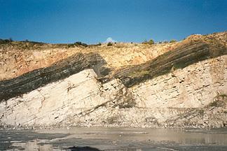
6 Scarps all fault types, all scales Northward across Coyote Creek Fault, San Jacinto Fault Zone
 - Formed by reactivation and by degradation of the former free face Stewart, Hancock 1990 Splintered scarp formed -during movement distriuted on en")
7 Fault scarp tectonic landform coinciding with fault plane Piedmont scarp formed during one movement in unconsolidated sediments Multiple scarp - Formed on parallel faults or branches of the fault during one movement Composite scarp (combined) - Formed by reactivation and by degradation of the former free face Stewart, Hancock 1990 Splintered scarp formed -during movement distriuted on en échelon fault segments
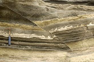
8 Fault scarp anatomy Toe and crest - upper and lower limit of fault scarp Free face - sub-vertical part, exposed alluvial fan deposits or slope deposits formed by movements can keep the shape years Debris slope scree cone accumulated bellow the free face by gravitation Wash slope part of slope on the toe controlled by fluvial erosion or accumulation Wallace 1977

9 Fault scarp degradation Stewart, Hancock, 1990 Wallace, 1977 Wallace, 1977

10 Fallon-Stillwater earthquake, July 6 th, 1954 M 6.6 Wallace, 1977 Pictures taken from 1954 and 1974 show several meters of retreat from the free face, forming a debris-slope.
 A young")

11 Scarp on Strike-Slip (oblique slip) A young scarp!! TINY! Carboneras fault, Spain Coyote Mts, Elsinore fault, CA


12 Scarps on normal fault Krupnik fault, Bulgary, 1904 M=7,8

13 Scarps on thrust fault Chichi earthquake 1999, Taiwan

14 Active or Inactive? Differential weathering along inactive faults can produce features that resemble features produced by active faults Vegetation lineaments, Linear valleys Scarps Known as Fault-Line Scarps Sometimes these features exist, but they are not associated with any active faulting!! (differential erosion)
 - scarps in alluvium, deflected drainages, sags, shutter ridges, side-hill benches A general rule is that active faults produce alluvium so they bury")
15 Some geomorphic features clearly indicate young activity (usually Holocene to late Quaternary) If it is expressed in the geomorphology, it is likely active (unless you can demonstrate that the features are totally erosional in nature) - scarps in alluvium, deflected drainages, sags, shutter ridges, side-hill benches A general rule is that active faults produce alluvium so they bury themselves, so locally, the evidence for activity may be obscured along some portions of the fault Christchurch EQ , M = 6.3, NZ - unknown fault, uplift of Southern Alps 10mm/year =high sedimentation, sediments obscure the fault trace

16 Active Strike-Slip Fault Geomorphology Burbank and Anderson, 2001
 All offsets are deflections, but")
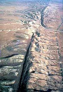
17 Effects on Stream Channels Offsets Implies a previously straight, now-curved channel as a result of displacement the bend in the channel must agree with the sense of slip! Deflections The curve in the channel can be with or against the sense of slip Result of drainage capture (water will take the easiest path downhill, alluvial fans) All offsets are deflections, but not all deflections are offsets!

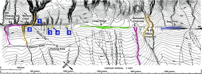
18 Offset channels Pitman Canyon ~ 46 - meter offsets


19 San Andreas Fault, Carrizo plain, CA

20 Offset channels Carizzo plain


21 Coyote Mts 0 10 km Coyote Mts 0 40 km

22 extension sag pond beheaded channels 5-8m cumulative sl 15m offset valley side Elsinore fault, Coyote Mts, CA

23 offset and beheaded channel fault 2m

24 Offset alluvial fans Elsinore 0 fault, 500 Coyote m Mts, CA
25 0 50m

26 offset alluvial fan


27 Laguna Salada fault, 2010, M= 7.2 El Mayor offset channel offset valley side

28 sag sag piercing/matching points Offset channel margin

29 Shutter Ridge Ridge moving along the fault blocked the valley Drainage Clark strand of the San Jacinto Shutter Ridge blocking drainage

30 Hector Mine Rupture, 1999

31 Linear valleys Linear valleys - related to faulting or just fault-line eroding crushed fault zone rocks
32 Transtension Component of divergence along SS fault (strike-slip) Right steps in dextral (right-lateral) SS fault Left steps in sinistral (left-lateral) SS fault Opening causes a sag, or pull-apart basin


33 Sag Ponds San Andreas Topographic depression produced by extensional bends or stepovers along a strike-slip fault. It may or may not contain water year-round. Synonymous with pull-apart basin.

34 Transpression Component of convergence along SS fault Left step in Dextral SS fault Right step in Sinistral SS Fault Right-step causes a space problem, and a pressure ridge is formed

35 Pressure ridge A topographic ridge produced by compressional bends or stepovers along a strike-slip fault Small pressure ridge along SAF in Cholame Valley


36 Dragon s Back Pressure Ridge System along the San Andreas

37 Pressure ridge Thousands Palms Indio Hills, San Andreas fault


38 Mole track structure Material is extruded along the fault by pressure Kunlun fault, Tibet, 2001 M = 7.8


39 SAF, San Francisco 1906, M = 7.9 Denali fault, Alaska
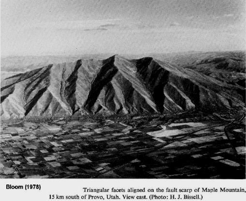
")
 Down-faulted")
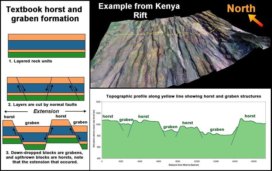
40 Extensional Faulting normal faults Displacement accommodated in normal faults Single, Parallel synthetic, Antithetic Primary normal fault (60-70 ) Crustal penetrating fault Often has km of displacement Separates linear mountain range from adjacent basin Up-faulted block (horst) Down-faulted block(graben)


41 Crustal extension and normal faults related to the most remarkable topography at regional scale Rifts valleys rift elevated heatflow, vertical compression, horizontal extension


42 East African Rift Valley active divergence, rift numerous of normal faults East African rift in 20 mil years


43 Hayli Gubbi, shield volcano, crater inside caldera, Afar region, Ethiopia Normal faults disecting the volcanos, Afar


44 Rift activity 2009 Massive fissure splits open in the Ethiopian Desert


45 Escarpments Rift Valley - Tanzania Main Ethiopian Rift Valley They has been formed during millions years
46

47 Hundreds meters high escarpments in Arba Minch area Arba Minch Abaya lake Nech Sar Chomo


48 broad extensional faulting Basin and Range topography Basin and Range Province extension and thinning of the lithosphere, listric faults, grabens, horsts elevated heat flow, geothermal energy From Sierra Nevada to Wasatch Mts 800 km


49 Linear mountain fronts Wasatch Mts Linear mountaint front - repeated earthquakes The Wasatch Mountains have been uplifted and tilted to the east by movement of the fault. The average rate of uplift along the fault is approximately 1 mm per year.

50 Scarp on the southern part of the Nephi strand of the Wasatch fault:
 in the past 18,000 years")
51 Wasatch fault Multiple fault scarps (marked by arrows) cut across 16,000 to 18,000-year-old glacial moraines in Salt Lake County. Some of the scarps - 30 to 40m high, indicating they were formed by repeated large earthquakes (7 to 10) in the past 18,000 years

52 Triangular (trapezoidal) facets - dissected mountain front by rivers, series of facets - flatirons un-named fault in California, SE from Panamint Valley
")
53 Several generation of facets evolution of mountain front Anderson (1977) Repeated episodic movements origin ot n hundreds meters high fault scarp fault-controlled mountain front hundreds kilometers long, up to 1 km high (Stewart, Hancock 1994)
54
55 Crustal shortening + thickening Crustal shortening is the reduction of the size of the Earth's crust through convergent plate boundary (compression)

56 Crustal Shortening Implications : - Reverse/Thrust Fault - Fold - Uplift
 Thrust faults often associated with fold - in fold-and-thrust belts - some of the thrusts and reverse fault may break the")

57 Thrust faults associated with subduction produce a variety of landforms - uplifted coastal terraces, anticlinal hills (upwarped) and synclinal lowlands (downwarped) Thrust faults often associated with fold - in fold-and-thrust belts - some of the thrusts and reverse fault may break the surface or they remain hidden in the core of anticline blind reverse fault Asymmetric fault-propagation fold developed over a décollement Reverse faults- closely related to folds Rate of lateral propagation of faults and fold may be sveral times higher than vertical slip rate of the fault

58 Landforms associated with reverse faulting steep mountain fronts, fault scarps, fold scarps, extensional features, and landslides

59 3-6 m slip on reverse fault at the depth, surface rupture - 2m mostly anticlinal uplift of 5m seismic folding Graph of surface uplift produced by 1980 El Asnam EQ. The fold was produced by repetaed earthquakes Bolcked river formation of a lake with deposition of 0.4 m

60 Fault scarps
61

62 Thompson and Turk, 1998
3. Landforms related to different types of movements
 3. Landforms related to different types of movements Faults / Zlomy 3 types of faults under different stress regimes (napěťových režimech): poklesové zlomy (normal fault), přesmykové zlomy (reverse fault,
Description of faults
 GLG310 Structural Geology Description of faults Horizontal stretch Crustal thickness Regional elevation Regional character Issues Normal Thrust/reverse Strike-slip >1 1 in one direction and < 1 in
Continental Landscapes
 Continental Landscapes Landscape influenced by tectonics, climate & differential weathering Most landforms developed within the last 2 million years System moves toward an equilibrium Continental Landscapes
Lecture # 6. Geological Structures
 1 Lecture # 6 Geological Structures ( Folds, Faults and Joints) Instructor: Dr. Attaullah Shah Department of Civil Engineering Swedish College of Engineering and Technology-Wah Cantt. 2 The wavy undulations
Geologic Structures. Changes in the shape and/or orientation of rocks in response to applied stress
 Geologic Structures Changes in the shape and/or orientation of rocks in response to applied stress Figure 15.19 Can be as big as a breadbox Or much bigger than a breadbox Three basic types Fractures >>>
Earthquake Tectonics and Hazards on the Continents June Recognizing and characterizing strike-slip faults and earthquakes in USA
 2464-4 Earthquake Tectonics and Hazards on the Continents 17-28 June 2013 Recognizing and characterizing strike-slip faults and earthquakes in USA S. G. Wesnousky Univ. of Nevada USA Strike-slip Faults
Chapter 15 Structures
 Chapter 15 Structures Plummer/McGeary/Carlson (c) The McGraw-Hill Companies, Inc. TECTONIC FORCES AT WORK Stress & Strain Stress Strain Compressive stress Shortening strain Tensional stress stretching
Geomorphology Final Exam Study Guide
 Geomorphology Final Exam Study Guide Geologic Structures STRUCTURAL GEOLOGY concerned with shapes, arrangement, interrelationships of bedrock units & endogenic (within) forces that cause them. Tectonic
Description of faults
 GLG310 Structural Geology Description of faults Horizontal stretch Crustal thickness Regional elevation Regional character Issues Normal Thrust/reverse Strike-slip >1 1 in one direction and < 1 in
Earth Science, (Tarbuck/Lutgens) Chapter 10: Mountain Building
 Chapter 10: Mountain Building") Earth Science, (Tarbuck/Lutgens) Chapter 10: Mountain Building 1) A(n) fault has little or no vertical movements of the two blocks. A) stick slip B) oblique slip C) strike slip D) dip slip 2) In a(n) fault,
Earth Science, (Tarbuck/Lutgens) Chapter 10: Mountain Building 1) A(n) fault has little or no vertical movements of the two blocks. A) stick slip B) oblique slip C) strike slip D) dip slip 2) In a(n) fault,
Crustal Deformation. Earth Systems 3209
 Crustal Deformation Earth Systems 3209 Crustal Deformation pg. 415 Refers to all changes in the original form and/or size of a rock body. May also produce changes in the location and orientation of rocks.
CRUSTAL DEFORMATION. Chapter 10
 CRUSTAL DEFORMATION and dgeologic Structures t Chapter 10 Deformation Df Deformation involves: Stress the amount of force applied to a given area. Types of Stress: Confining Stress stress applied equally
Active Tectonics. Earthquakes, Uplift, and Landscape. Edward A. Keller University of California, Santa Barbara
 Prentice Hall Earth Science Series SUB Gottingen 214 80416X, im ^, 2002 A 7883 lllllllilwii Active Tectonics Earthquakes, Uplift, and Landscape Second Edition V Edward A. Keller University of California,
Section 10.1 The Nature of Volcanic Eruptions This section discusses volcanic eruptions, types of volcanoes, and other volcanic landforms.
 Chapter 10 Section 10.1 The Nature of Volcanic Eruptions This section discusses volcanic eruptions, types of volcanoes, and other volcanic landforms. Reading Strategy Previewing Before you read the section,
Earthquakes. Earthquakes are caused by a sudden release of energy
 Earthquakes Earthquakes are caused by a sudden release of energy The amount of energy released determines the magnitude of the earthquake Seismic waves carry the energy away from its origin Fig. 18.1 Origin
Not For Web Reproduction. New Topic: TECTONIC GEOMORPHOLOGY. Tectonic Geomorphology vs. Structural Geomorphology
 New Topic: TECTONIC GEOMORPHOLOGY Tectonic Geomorphology vs. Structural Geomorphology Late Cenozoic Tectonic Movement vs. Late Cenozoic Erosion of Older Structures Geologic Time Scale Not For Web Reproduction
Plate Tectonics - Demonstration
 Name: Reference: Prof. Larry Braile - Educational Resources Copyright 2000. L. Braile. Permission granted for reproduction for non-commercial uses. http://web.ics.purdue.edu/~braile/indexlinks/educ.htm
Chapter 10: Volcanoes and Other Igneous Activity Section 1: The Nature of Volcanic Eruptions I. Factors Affecting Eruptions Group # Main Idea:
 Chapter 10: Volcanoes and Other Igneous Activity Section 1: The Nature of Volcanic Eruptions I. Factors Affecting Eruptions Group # A. Viscosity Group # B. Dissolved Gases Group # II. Volcanic Material
mountain rivers fixed channel boundaries (bedrock banks and bed) high transport capacity low storage input output
 high transport capacity low storage input output") mountain rivers fixed channel boundaries (bedrock banks and bed) high transport capacity low storage input output strong interaction between streams & hillslopes Sediment Budgets for Mountain Rivers Little
mountain rivers fixed channel boundaries (bedrock banks and bed) high transport capacity low storage input output strong interaction between streams & hillslopes Sediment Budgets for Mountain Rivers Little
Crustal Deformation Earth - Chapter Pearson Education, Inc.
 Crustal Deformation Earth - Chapter 10 Structural Geology Structural geologists study the architecture and processes responsible for deformation of Earth s crust. A working knowledge of rock structures
December 21, Chapter 11 mountain building E.notebook. Feb 19 8:19 AM. Feb 19 9:28 AM
 Mountains form along convergent plate boundaries. Typically (usually) if you look at a mountain range, you know that it is at a plate boundary (active continental margin) or has been some time in the past
Crustal Deformation. (Building Earth s Surface, Part 1) Science 330 Summer Mapping geologic structures
 Science 330 Summer Mapping geologic structures") Crustal Deformation (Building Earth s Surface, Part 1) Science 330 Summer 2005 Mapping geologic structures When conducting a study of a region, a geologist identifies and describes the dominant rock structures
Crustal Deformation (Building Earth s Surface, Part 1) Science 330 Summer 2005 Mapping geologic structures When conducting a study of a region, a geologist identifies and describes the dominant rock structures
PHYSICAL GEOGRAPHY General Information
 PHYSICAL GEOGRAPHY General Information By understanding the environment we can understand why one place is different or the same as another. See handout Geomorphology Geo --Land morph --Change ology --Study
KEY CHAPTER 12 TAKE-HOME QUIZ INTERNAL STRUCTURES AND PROCESSES Score Part B = / 55 PART B
 GEOLOGY 12 KEY CHAPTER 12 TAKE-HOME QUIZ INTERNAL STRUCTURES AND PROCESSES Score Part B = / 55 PART B CHAPTER 12 Isostacy and Structural Geology 1. Using the terms below, label the following diagrams and
Chapter 16. Mountain Building. Mountain Building. Mountains and Plate Tectonics. what s the connection?
 Chapter 16 Mountains and Plate Tectonics what s the connection? Mountain Building Most crustal deformation occurs along plate margins. S.2 Active Margin Passive Margin Mountain Building Factors Affecting
Landscape evolution. An Anthropic landscape is the landscape modified by humans for their activities and life
 Landforms Landscape evolution A Natural landscape is the original landscape that exists before it is acted upon by human culture. An Anthropic landscape is the landscape modified by humans for their activities
8 th Grade Science Plate Tectonics and Topography Review
 8 th Grade Science Plate Tectonics and Topography Review #1 Scientists believe that the land masses of Earth were once joined together as one supercontinent called. A: Australia B: Wegner C: Pangaea D:
Directed Reading. Section: How Mountains Form MOUNTAIN RANGES AND SYSTEMS. Skills Worksheet
 Skills Worksheet Directed Reading Section: How Mountains Form 1. How high is Mount Everest? a. about 1980 km above sea level b. more than 8 km below sea level c. more than 8 km above sea level d. more
Introduction Faults blind attitude strike dip
 Chapter 5 Faults by G.H. Girty, Department of Geological Sciences, San Diego State University Page 1 Introduction Faults are surfaces across which Earth material has lost cohesion and across which there
Strike-Slip Faults. ! Fault motion is parallel to the strike of the fault.
 Strike-Slip Faults! Fault motion is parallel to the strike of the fault.! Usually vertical, no hanging-wall/footwall blocks.! Classified by the relative sense of motion. " Right lateral opposite block
depression above scarp scarp
 1 LAB 1: FIELD TRIP TO McKINLEYVILLE AND MOUTH OF THE MAD RIVER OBJECTIVES: a. to look at geomorphic and geologic evidence for large scale thrust-faulting of young sediments in the Humboldt Bay region
Earth s Many Landforms. Earth s Many Landforms. Earth s Many Landforms. Crustal Deformation. Crustal Deformation 10/22/2014
 Hewitt/Lyons/Suchocki/Yeh Conceptual Integrated Science Chapter 24 EARTH S SURFACE LAND AND WATER Earth s Many Landforms Earth consists of seven continents: Africa, Antarctica, Asia, Australia, Europe,
Mountains and Mountain Building: Chapter 11
 Mountains and Mountain Building: Chapter 11 Objectives: 1)Explain how some of Earth s major mountain belts formed 2) Compare and contrast active and passive continental margins 3) Explain how compression,
Landforms and Rock Structure
 Landforms and Rock Structure Rock Structure as a Landform Control Landforms of Horizontal Strata and Coastal Plains Landforms of Warped Rock Layers Landforms Developed on Other Land-Mass Types Landforms
COSMORPHOLOGY - May 2009
 Name COSMORPHOLOGY - May 2009 Geologic landforms Purpose: By studying aerial photographs you will learn to identify different kinds of geologic features based on their different morphologies and learn
UNIT 10 MOUNTAIN BUILDING AND EVOLUTION OF CONTINENTS
 UNIT 10 MOUNTAIN BUILDING AND EVOLUTION OF CONTINENTS ROCK DEFORMATION Tectonic forces exert different types of stress on rocks in different geologic environments. STRESS The first, called confining stress
What Causes Rock to Deform?
 Crustal Deformation Earth, Chapter 10 Chapter 10 Crustal Deformation What Causes Rock to Deform? Deformation is a general term that refers to all changes in the shape or position of a rock body in response
Essentials of Geology, 11e
 Essentials of Geology, 11e Crustal Deformation and Mountain Building Chapter 17 Instructor Jennifer Barson Spokane Falls Community College Geology 101 Stanley Hatfield Southwestern Illinois College Jennifer
How to Build a Mountain and other Geologic Structures. But first a short review
 How to Build a Mountain and other Geologic Structures But first a short review Where do we see deep earthquakes? What is happening there? What can happen at a plate boundary? 1. Plates can move apart
Mountains are then built by deforming crust: Deformation & Mountain Building. Mountains form where stresses are high!
 Deformation & Mountain Building Where are mountains located? Deformation and Folding Mountain building Mountains form where stresses are high! Mountains form at all three types of plate boundaries where
UNIT 3 GEOLOGY VOCABULARY FLASHCARDS THESE KEY VOCABULARY WORDS AND PHRASES APPEAR ON THE UNIT 3 CBA
 UNIT 3 GEOLOGY VOCABULARY FLASHCARDS THESE KEY VOCABULARY WORDS AND PHRASES APPEAR ON THE UNIT 3 CBA A map that shows Earth s Topographic Map surface topography, which is Earth s shape and features Contour
FINAL EXAM Crustal Deformation CONVERGE DIVERGENT PLATES MANTLE PLUMES FLUX BASALTIC GRANITIC
 Crustal Deformation Reading: Chapter 10 Pages 283-304 Review Questions 4, 6, 7, 10, 12, 15, 18, 20 FINAL EXAM NOON TO 2 PM, TUESDAY DEC. 5 HERE: Natural Science 101 BRING A SCAN TRON TURN IN YOUR REVIEW
Geologic Landforms Seen on Aerial Photos Instructor Notes
 1.5 hours Exercise Two Geologic Landforms Instructor Notes Suggested Correlation of Topics Geomorphology, gradation, impact cratering, tectonism, volcanism, photography Purpose The objective of this exercise
Plate Tectonics. entirely rock both and rock
 Plate Tectonics I. Tectonics A. Tectonic Forces are forces generated from within Earth causing rock to become. B. 1. The study of the origin and arrangement of Earth surface including mountain belts, continents,
Geology 300, Physical Geology Spring 2019 Quiz Ch 19, Plate Tectonics Name
 Geology 300, Physical Geology Spring 2019 Quiz Ch 19, Plate Tectonics Name MULTIPLE CHOICE. Choose the one alternative that best completes the statement or answers the question. 1) The portion of a fracture
Learning Objectives (LO) What we ll learn today:!
 What we ll learn today:!") Learning Objectives (LO) Lecture 13: Mountain Building Read: Chapter 10 Homework #11 due Tuesday 12pm What we ll learn today:! 1. Define the types of stress that are present in the crust! 2. Define the
Learning Objectives (LO) Lecture 13: Mountain Building Read: Chapter 10 Homework #11 due Tuesday 12pm What we ll learn today:! 1. Define the types of stress that are present in the crust! 2. Define the
Copyright McGraw-Hill Education. All rights reserved. No reproduction or distribution without the prior written consent of McGraw-Hill Education
 Copyright McGraw-Hill Education. All rights reserved. No reproduction or distribution without the prior written consent of McGraw-Hill Education Tibetan Plateau and Himalaya -southern Asia 11.00.a VE 10X
Rilles Lunar Rilles are long, narrow, depressions formed by lava flows, resembling channels.
 Rilles Lunar Rilles are long, narrow, depressions formed by lava flows, resembling channels. Rugged Terra Rugged terra are mountainous regions of the moon. Wrinkle Ridges Wrinkle Ridges are created through
Layers of the Earth Date: SWABT: Identify and describe the layers of the Earth and their characteristics
 Layers of the Earth SWABT: Identify and describe the layers of the Earth and their characteristics CRUST Composition: Thickness: State of Matter: : Mostly Basalt : Mostly Granite : Crust and Upper Mantle
Geo736: Seismicity and California s Active Faults Introduction
 Geo736: Seismicity and California s Active Faults Course Notes: S. G. Wesnousky Spring 2018 Introduction California sits on the boundary of the Pacific - North American plate boundary (Figure 1). Relative
Deformation of Rocks. Orientation of Deformed Rocks
 Deformation of Rocks Folds and faults are geologic structures caused by deformation. Structural geology is the study of the deformation of rocks and its effects. Fig. 7.1 Orientation of Deformed Rocks
Examining the Terrestrial Planets (Chapter 20)
") GEOLOGY 306 Laboratory Instructor: TERRY J. BOROUGHS NAME: Examining the Terrestrial Planets (Chapter 20) For this assignment you will require: a calculator, colored pencils, a metric ruler, and your geology
GEOLOGY 306 Laboratory Instructor: TERRY J. BOROUGHS NAME: Examining the Terrestrial Planets (Chapter 20) For this assignment you will require: a calculator, colored pencils, a metric ruler, and your geology
TAKE HOME EXAM 8R - Geology
 Name Period Date TAKE HOME EXAM 8R - Geology PART 1 - Multiple Choice 1. A volcanic cone made up of alternating layers of lava and rock particles is a cone. a. cinder b. lava c. shield d. composite 2.
Section 3 Deforming Earth s Crust
 Section 3 Deforming Earth s Crust Key Concept Tectonic plate motions deform Earth s crust. Deformation causes rock layers to bend and break and causes mountains to form. What You Will Learn Stress is placed
Basin & Range / Mojave Desert
 Basin & Range / Mojave Desert Basin & Range vs. Great Basin 1 2/20/2016 An overview of the last horst Basin and Range / Mojave Desert Summary: Granitic, volcanic, marine sedimentary, non marine sedimentary,
Determination of uplift rates of fluvial terraces across the Siwaliks Hills, Himalayas of central Nepal
 Determination of uplift rates of fluvial terraces across the Siwaliks Hills, Himalayas of central Nepal Martina Böhme Institute of Geology, University of Mining and Technology, Freiberg, Germany Abstract.
Taiwan, (Sathiyam.tv)
") Taiwan, 1999. (Sathiyam.tv) This document was modified and supplemented by BYU-Idaho faculty. All illustrations are from USGS unless otherwise noted. Learning Objectives Your goals in studying this chapter
Taiwan, 1999. (Sathiyam.tv) This document was modified and supplemented by BYU-Idaho faculty. All illustrations are from USGS unless otherwise noted. Learning Objectives Your goals in studying this chapter
How mountains are made. We will talk about valleys (erosion and weathering later)
") How mountains are made We will talk about valleys (erosion and weathering later) http://www.ilike2learn.com/ilike2learn/mountainmaps/mountainranges.html Continent-continent plate convergence Less dense,
How mountains are made We will talk about valleys (erosion and weathering later) http://www.ilike2learn.com/ilike2learn/mountainmaps/mountainranges.html Continent-continent plate convergence Less dense,
Plate Boundaries & Resulting Landforms
 Plate Boundaries & Resulting Landforms Divergent Plate Boundaries (plates being pulled apart) Type: oceanic plates Description: rising magma gently lifts the crust creating a ridge. The flow of convection
Movement of the Earth s Crust: Formation of: Mountain s Plateau's and Dome s
 Movement of the Earth s Crust: Formation of: Mountain s Plateau's and Dome s References Information taken from several places including Prentice Hall Earth Science: @ http://www.eram.k12.ny.us/education/components/docmgr/default.php?sectiondetaili
Landforms. Why does the land look like it does? 1. Controlled by water 2. Controlled by the rocks
 Landforms Why does the land look like it does? 1. Controlled by water 2. Controlled by the rocks Landforms Made by Running Water Stream erosion The evolution of a river system Entrenched meanders Fluvial
Lab 7: STRUCTURAL GEOLOGY FOLDS AND FAULTS
 Lab 7: STRUCTURAL GEOLOGY FOLDS AND FAULTS This set of labs will focus on the structures that result from deformation in earth s crust, namely folds and faults. By the end of these labs you should be able
24. Ocean Basins p
 24. Ocean Basins p. 350-372 Background The majority of the planet is covered by ocean- about %. So the majority of the Earth s crust is. This crust is hidden from view beneath the water so it is not as
STAAR Science Tutorial 40 TEK 8.9C: Topographic Maps & Erosional Landforms
 Name: Teacher: Pd. Date: STAAR Science Tutorial 40 TEK 8.9C: Topographic Maps & Erosional Landforms TEK 8.9C: Interpret topographic maps and satellite views to identify land and erosional features and
A Classification of Forces Affecting the Landforms
 Landforms There are many forms of land on the surface of the earth. Continents, oceans, mountains, plateaus, valleys, deltas, etc., are some of the examples of landforms. Landforms can be divided into
Cenozoic Extensional Basin Development and Sedimentation in SW Montana
 Cenozoic Extensional Basin Development and Sedimentation in SW Montana Robert C. Thomas Department of Environmental Sciences, The University of Montana Western, Dillon, MT 59725, (406) 683-7615, r_thomas@umwestern.edu
Lecture Outlines PowerPoint. Chapter 10 Earth Science, 12e Tarbuck/Lutgens
 Lecture Outlines PowerPoint Chapter 10 Earth Science, 12e Tarbuck/Lutgens 2009 Pearson Prentice Hall This work is protected by United States copyright laws and is provided solely for the use of instructors
STRUCTURE AND HOLOCENE SLIP OF THE JID FAULT, MONGOLIA ALTAI
 STRUCTURE AND HOLOCENE SLIP OF THE JID FAULT, MONGOLIA ALTAI LAURA K.O. SMITH AND SARAHTSETSEG PUREDORG Princeton University, Mongolian University of Science and Technology Sponsors: Ramon Gonzalez-Mieres
Unit 7.2 W.E.D. & Topography Test
 Name: Score: Unit 7.2 W.E.D. & Topography Test 1. 2. 3. 4. 5. 6. 7. 8. 9. 10. 11. 12. 13. 14. 15. 16. 17. 18. 19. 20. 21. 22. 23. 24. 25. 1. The formation of mountains is due mainly to while the destruction
Topography the natural and human features of the Earth s surface. ie. Surface features need to understand difference between relief and elevation
 Chapter 1 Landform Patterns and Processes Highlighted script will not be assessed Topography the natural and human features of the Earth s surface. ie. Surface features need to understand difference between
Forces That Shape Earth. How do continents move? What forces can change rocks? How does plate motion affect the rock cycle?
 Forces That Shape Earth How do continents move? What forces can change rocks? How does plate motion affect the rock cycle? Plate Motion Mountain ranges are produced by plate tectonics. The theory of plate
Overview of the Seismic Source Characterization for the Palo Verde Nuclear Generating Station
 Overview of the Seismic Source Characterization for the Palo Verde Nuclear Generating Station Scott Lindvall SSC TI Team Lead Palo Verde SSC SSHAC Level 3 Project Tuesday, March 19, 2013 1 Questions from
GEOLOGIC MAPS PART II
 EARTH AND ENVIRONMENT THROUGH TIME LABORATORY - EES 1005 LABORATORY FIVE GEOLOGIC MAPS PART II Introduction Geologic maps of orogenic belts are much more complex than maps of the stable interior. Just
Goals of Today s Lecture. Types of landscapes
 Goals of Today s Lecture 1. Breifly discuss mass continuity as applied to the landscape. 2. Establish the mechanisms that drive U (uplift rate) 3. Examine the linkages between the uplift of mountains,
Neotectonic Implications between Kaotai and Peinanshan
 Neotectonic Implications between Kaotai and Peinanshan Abstract Longitudinal Valley was the suture zone between the Philippine Sea plate and the Eurasia plate. Peinanshan was the southest segment of the
Staple this part to part one of lab 6 and turn in. Lab 6, part two: Structural geology (analysis)
") Geology 101 Staple this part to part one of lab 6 and turn in Lab 6, part two: Structural geology (analysis) Recall that the objective of this lab is to describe the geologic structures of Cougar Mountain
Geology 101 Staple this part to part one of lab 6 and turn in Lab 6, part two: Structural geology (analysis) Recall that the objective of this lab is to describe the geologic structures of Cougar Mountain
Plate Tectonics. Structure of the Earth
 Plate Tectonics Structure of the Earth The Earth can be considered as being made up of a series of concentric spheres, each made up of materials that differ in terms of composition and mechanical properties.
Social Studies 9 UNIT 2 GEOGRAPHIC INFLUENCES ON IDENTITY: PLACE AND PEOPLE
 Social Studies 9 UNIT 2 GEOGRAPHIC INFLUENCES ON IDENTITY: PLACE AND PEOPLE The Structure of the Earth To understand the forces that create Canada's physical landscape we must understand the structure
Laboratory Exercise #4 Geologic Surface Processes in Dry Lands
 Page - 1 Laboratory Exercise #4 Geologic Surface Processes in Dry Lands Section A Overview of Lands with Dry Climates The definition of a dry climate is tied to an understanding of the hydrologic cycle
Shape Earth. Plate Boundaries. Building. Building
 Chapter Introduction Lesson 1 Lesson 2 Lesson 3 Lesson 4 Chapter Wrap-Up Forces That Shape Earth Landforms at Plate Boundaries Mountain Building Continent Building How is Earth s surface shaped by plate
deep within the planet. They are also shaped by conditions on the planet s surface. In
 Chapter 4 Landforms, Water, and Natural Resources Earth is home to many different types of landforms. These landforms are shaped by forces deep within the planet. They are also shaped by conditions on
How to Build a Mountain and other Geologic Structures. But first, questions
 How to Build a Mountain and other Geologic Structures But first, questions Questions your students might ask How were Montana s mountains formed? How old are the mountains? What are the different ways
Stress and Strain. Stress is a force per unit area. Strain is a change in size or shape in response to stress
 Geologic Structures Geologic structures are dynamically-produced patterns or arrangements of rock or sediment that result from, and give information about, forces within the Earth Produced as rocks change
Crags, Cracks, and Crumples: Crustal Deformation and Mountain Building
 Crags, Cracks, and Crumples: Crustal Deformation and Mountain Building Updated by: Rick Oches, Professor of Geology & Environmental Sciences Bentley University Waltham, Massachusetts Based on slides prepared
Activity Pacific Northwest Tectonic Block Model
 Activity Pacific Northwest Tectonic Block Model The Cascadia tectonic margin is caught between several tectonic forces, during the relentless motions of the giant Pacific Plate, the smaller subducting
Physical Geography A Living Planet
 Physical Geography A Living Planet The geography and structure of the earth are continually being changed by internal forces, like plate tectonics, and external forces, like the weather. Iguaçu Falls at
Mountain Building. Mountain Building
 Mountain Building Mountain building has occurred during the recent geologic past American Cordillera the western margin of the Americas from Cape Horn to Alaska Includes the Andes and Rocky Mountains Alpine
Terrain Units PALEOGEOGRAPHY: LANDFORM CREATION. Present Geology of NYS. Detailed Geologic Map of NYS
 NYS TOPOGRAPHY Why so? PALEOGEOGRAPHY: LANDFORM CREATION Prof. Anthony Grande AFG 014 Present Geology of NYS Detailed Geologic Map of NYS Generalized Geology Detailed Geology Hot links to the fold out
11.1 Rock Deformation
 Tarbuck Lutgens Mountain Building 11.1 Rock Deformation Factors Affecting Deformation Factors that influence the strength of a rock and how it will deform include temperature, confining pressure, rock
A Model of Three Faults
 A Model of Three Faults Grades 7-12 Adapted from the USGS Learning Web Lesson Plans Background One of the most frightening and destructive phenomena of nature is a severe earthquake and its terrible aftereffects.
FINAL EXAM Crustal Deformation CONVERGE DIVERGENT PLATES MANTLE PLUMES FLUX BASALTIC GRANITIC
 Crustal Deformation Reading: Chapter 10 Pages 283-294 FINAL EXAM 8 to 10 AM, THURSDAY DEC. 6 HERE: Natural Science 101 BRING A SCAN TRON TURN IN YOUR REVIEW QUESTIONS BEFORE THE TEST, PICK UP WHEN YOU
Page 1. Name:
 Name: 1) Which property would best distinguish sediment deposited by a river from sediment deposited by a glacier? thickness of sediment layers age of fossils found in the sediment mineral composition
Unit 4 Lesson 7 Mountain Building
 Indiana Standards 7.2.4 Explain how convection currents in the mantle cause lithospheric plates to move causing fast changes like earthquakes and volcanic eruptions, and slow changes like creation of mountains
USU 1360 TECTONICS / PROCESSES
 USU 1360 TECTONICS / PROCESSES Observe the world map and each enlargement Pacific Northwest Tibet South America Japan 03.00.a1 South Atlantic Arabian Peninsula Observe features near the Pacific Northwest
Topic 12: Dynamic Earth Pracatice
 Name: Topic 12: Dynamic Earth Pracatice 1. Earth s outer core is best inferred to be A) liquid, with an average density of approximately 4 g/cm 3 B) liquid, with an average density of approximately 11
The Devils Postpile and its Unusual Surroundings. Shannon B. Carpenter A May 3, 2001
 The Devils Postpile and its Unusual Surroundings Shannon B. Carpenter A25584605 May 3, 2001 Abstract: The Devils Postpile is located in the eastern Sierra Nevada region just a few miles southwest of the
FLUVIAL LANDFORMS. Floodplains
 FLUVIAL LANDFORMS Floodplains fairly flat & continuous surface occupying much of a valley bottom normally underlain by unconsolidated sediments subject to periodic flooding (usually once every year or
World Geography 3202 Unit 1. Ch. 1: Landform Patterns and Processes
 World Geography 3202 Unit 1 Ch. 1: Landform Patterns and Processes - Planet Earth is dynamic - behaves as if it s a living organism - some changes are rapid enough for us to see and record - exs. Tidal
Chapter 10: Deformation and Mountain Building. Fig. 10.1
 Chapter 10: Deformation and Mountain Building Fig. 10.1 OBJECTIVES Describe the processes of rock deformation and compare and contrast ductile and brittle behavior in rocks. Explain how strike and dip
Earth Science. STREAM DRAINAGE PATTERNS (start by reading the first page of these notes!)
") Name _ Earth Science STREAM DRAINAGE PATTERNS (start by reading the first page of these notes!) WHAT IS A DRAINAGE PATTERN? Streams seek the lowest path as they move downhill, and they tend to erode their
Name _ Earth Science STREAM DRAINAGE PATTERNS (start by reading the first page of these notes!) WHAT IS A DRAINAGE PATTERN? Streams seek the lowest path as they move downhill, and they tend to erode their