Fault growth & linkage
|
|
|
- Philomena Todd
- 5 years ago
- Views:
Transcription
1 Fault growth & linkage Important to understand fault growth, interaction & linkage Continental extension and basin formation Controls on subsurface fluid flow Hydrocarbon exploration & production Minerals Groundwater Waste management/disposal Hazard assessment EARS5136 slide 1

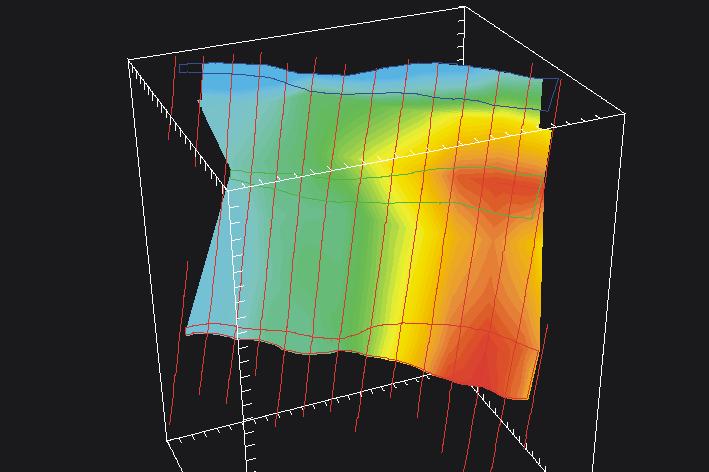
2 3D Fault Array: Continuity EARS5136 slide 2

3 3D Fault Array: Reservoir models EARS5136 slide 3
4 EARS5136 slide 4
 Reverse drag r Displacement not to scale EARS5136 slide")
5 Displacement pattern on an isolated normal fault - after Barnett et al. (1987) Reverse drag r Displacement not to scale EARS5136 slide 5

6 Normal fault Coal field EARS5136 slide 6
7 Gulf Coast normal fault EARS5136 slide 7

8 Single fault North Sea seismic data a b EARS5136 slide 8

9 Fault surface topography EARS5136 slide 9
10 Normal fault - Oregon Throw and Separation Single fault from surface exposure in central Oregon Maximum separation (throw) near centre of fault. Gradual taper of separation profile from a maximum separation to zero at the fault tips. EARS5136 slide 10

11 West Africa: lower fault tips & conjugate faults EARS5136 slide 11

12 Low throw normal faults EARS5136 slide 12
13 Fault dimensions Aspect ratios average 2:1 but variable Linear throw gradients on isolated faults Non-linear on restricted faults Steeper gradients near overlapping tips EARS5136 slide 13
14 Fault aspect ratios Location Average aspect ratio Derbyshire coalmines UK 2.3 Timor Sea 2.2 Gulf Coast, USA 1.6 North Sea 2.4 From Nicol et al. (1996) EARS5136 slide 14
15 Fault dimensions From Nicol et al. (1996) EARS5136 slide 15
16 Restricted faults EARS5136 slide 16

17 Structure contours Beatrice field Map view Footwall anticline: Cross-section A-A shows form of footwall anticline. Maximum uplift near center of fault. Transverse section through hanging wall Hangingwall syncline: Maximum structural low near center of fault. Schlische, 1995 EARS5136 slide 17
18 Deformation around a fault Large scale faults generate isostatic footwall uplift and hangingwall subsidence Strain around the fault produces reverse drag Normal drag localized around the fault Flexural isostatic effects. EARS5136 slide 18

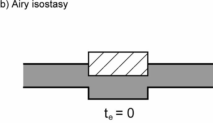
19 Isostasy EARS5136 slide 19

20 Flexural cantilever EARS5136 slide 20

 EARS5136")
21 Footwall uplift: Gullfaks field From: Husmo et al.(2002) EARS5136 slide 21

 EARS5136")
22 North Viking Graben From: Husmo et al.(2002) EARS5136 slide 22
23 Deformation around a fault Reverse drag profiles generate: footwall uplift hangingwall subsidence Relationship of structure contours to fault vary with slip direction Reverse drag does not imply a listric fault Earthquake related elastic strains relax to permanent bed deformation EARS5136 slide 23
24 Earthquake induced deformation < Imperial Valley earthquake 1940 Slip = e -3.5dist 0.03dist Strike-slip illustrates offsets Borah Peak earthquake 1983 > Lost River fault, Idaho EARS5136 slide 24

25 Deformation around a fault Radar interferometry image of ground deformation induced by Hector Mine earthquake Magnitude: 7.1 Depth 5±3 km Right-lateral strike-slip Length of surface rupture: 41 km Maximum surface offset 5.2 m EARS5136 slide 25
26 Fault drag profiles Empirical relationships for: Single event: Slip = e -3.5dist 0.03dist Multiple event steady state: Slip = e -5.5dist 0.004dist From Gibson et al. (1989) EARS5136 slide 26
27 Modelling bed contours Around blind faults (a-e) and synsedimentary fault (f). From Gibson et al. (1989) EARS5136 slide 27

28 Structure contours around an isolated normal fault EARS5136 slide 28
29 Hangingwall & footwall displacement Same in hangingwall and footwall for blind faults Greater hangingwall subsidence than footwall uplift for synsedimentary faults Percentage contribution of hangingwall displacement (HW) is given by: HW = 110 2θ/3 Where θ is fault dip and dip exceeds 30 degrees EARS5136 slide 29
30 Patterns around synsedimentary faults EARS5136 slide 30

31 Patterns around synsedimentary faults: a local example The Craven fault zone EARS5136 slide 31

32 Normal drag in footwall to a 6m throw normal fault: Carboniferous, Anglesey Normal drag profiles often highly localised around fault EARS5136 slide 32

33 Fault shape & linkage EARS5136 slide 33
34 Possible modes of fault linkage after Childs et al. (1995) a b c EARS5136 slide 34


35 a Displacement pattern correlated single fault 2D-seismic data set Middle East b EARS5136 slide 35

36 Displacement pattern correlated multiple faults 2D-seismic data set Middle East a b EARS5136 slide 36
37 Displacement patterns on overlapping faults from Childs et al. (1995) EARS5136 slide 37
38 Relay ramp structure and displacement patterns on overlapping faults from Huggins et al. (1995) A B Relay ramp structure and displacement patterns on overlapping faults. Summed throws give a coherent pattern. From Huggins et al. (1995) EARS5136 slide 38
39 Fault displacement and linkage patterns differences between higher and lower mapped horizons from Childs et al. (1995) EARS5136 slide 39

40 Segmented fault zone, Timor Sea from Childs et al. (1995) EARS5136 slide 40
41 Displacement patterns on overlapping faults from Childs et al. (1995) Fault 1 Fault 2 Aggregate throw EARS5136 slide 41
42 Relay zone structure from Peacock & Sanderson (1994) EARS5136 slide 42
43 Hard linked faults (Krantz 1988) Fault map Vertical separation EARS5136 slide 43

44 Relay ramps seismic mapping EARS5136 slide 44

45 Relay ramps seismic mapping EARS5136 slide 45

46 Relay ramp EARS5136 slide 46
47 Relay zone structure from Peacock & Sanderson (1994) EARS5136 slide 47
48 Fault displacement profiles From Nicol et al. (1996) EARS5136 slide 48
49 Geometric coherence From Walsh et al. (2003) EARS5136 slide 49
50 Different styles of transfer zones (Morley 1990) EARS5136 slide 50


51 NE-SW Cross-cutting faults NW-SE Interacting EARS5136 slide 51

52 Cross-cutting faults EARS5136 slide 52
53 Hard-linked splays EARS5136 slide 53

54 Conjugate faults EARS5136 slide 54

55 Conjugate faults EARS5136 slide 55

56 EARS5136 slide 56
57 Growth rates & slip rates Higher strain rate basins have higher slip rates on faults rather then more faults Large faults grow faster Large faults relatively large throughout growth of fault system Rates to 1.0mmyr -1 : 0.188mmyr -1 (GOM) 0.030mmyr -1 (North Sea) 0.074mmyr -1 (Timor Sea) 0.248mmyr -1 (Aegean) 0.098mmyr -1 (Basin & Range) 0.049mmyr -1 (Kenya Rift) EARS5136 slide 57
Genetic models of structural traps related to normal faults in the Putaohua Oilfield, Songliao Basin
 302 DOI 10.1007/s12182-008-0050-0 Genetic models of structural traps related to normal faults in the Putaohua Oilfield, Songliao Basin Sun Simin 1, Wu Xinsong 1, Liu Hongtao 2 and Wang Changsheng 2 1 School
Fault History analysis in Move
 Fault History analysis in Move The new Fault History plot in Move provides a method to conduct a quick-look analysis of the evolution of faults through time. By restoring the vertical displacement of a
Constrained Fault Construction
 Constrained Fault Construction Providing realistic interpretations of faults is critical in hydrocarbon and mineral exploration. Faults can act as conduits or barriers to subsurface fluid migration and
Elliptical Fault Flow
 Elliptical Fault Flow Elliptical Fault Flow provides a new way to model and restore faults with variable offsets using Move. This new kinematic algorithm was created by Midland Valley, and is accessed
T-z profiles can elucidate the kinematic history of normal faults (i.e. fault nucleation, growth, and/or
 GSA Data Repository 2018026 Phillips et al., 2018, Determining the three-dimensional geometry of a dike swarm and its impact on later rift geometry using seismic reflection data: Geology, https://doi.org/10.1130/g39672.1.
Elastic models of deformation in nature: why shouldn t we use the present day fault geometry?
 Elastic models of deformation in nature: why shouldn t we use the present day fault geometry? B. Freeman 1, G. Yielding, 1 S.J. Dee 1, 2, & P.G. Bretan 1 1 Badley Geoscience Limited, UK 2 BP Exploration
STRAIN AND SCALING RELATIONSHIPS OF FAULTS AND VEINS AT KILVE, SOMERSET
 Read at the Annual Conference of the Ussher Society, January 1995 STRAIN AND SCALING RELATIONSHIPS OF FAULTS AND VEINS AT KILVE, SOMERSET M. O'N. BOWYER AND P. G. KELLY Bowyer, M. O'N. and Kelly, P.G.
Description of faults
 GLG310 Structural Geology Description of faults Horizontal stretch Crustal thickness Regional elevation Regional character Issues Normal Thrust/reverse Strike-slip >1 1 in one direction and < 1 in
Jocelyn Karen Campbell
 THE UNCERTAINTIES IN ASSESSING THE IMPACT OF REGIONAL SEISMICITY AT THE WIL SITE Statement of Evidence by Jocelyn Karen Campbell A CANTERBURY FAULTS coded by type CHARACTERISTICS OF THRUST FAULTS IN CANTERBURY
Stress and Strain. Stress is a force per unit area. Strain is a change in size or shape in response to stress
 Geologic Structures Geologic structures are dynamically-produced patterns or arrangements of rock or sediment that result from, and give information about, forces within the Earth Produced as rocks change
11.1 Rock Deformation
 Tarbuck Lutgens Mountain Building 11.1 Rock Deformation Factors Affecting Deformation Factors that influence the strength of a rock and how it will deform include temperature, confining pressure, rock
Deformation of Rocks. Orientation of Deformed Rocks
 Deformation of Rocks Folds and faults are geologic structures caused by deformation. Structural geology is the study of the deformation of rocks and its effects. Fig. 7.1 Orientation of Deformed Rocks
Types and Briyfly Origins of the Extensional Fault-Related Folds
 IOSR Journal of Engineering (IOSRJEN) ISSN (e): 2250-3021, ISSN (p): 2278-8719 Vol. 06, Issue 01 (January. 2016), V2 PP 39-43 www.iosrjen.org Types and Briyfly Origins of the Extensional Fault-Related
THE HETEROGENEOUS STRUCTURE OF FAULT ZONES WITHIN CARBONATE ROCKS: EVIDENCE FROM OUTCROP STUDIES AND IMPLICATIONS FOR FLUID FLOW
 THE HETEROGENEOUS STRUCTURE OF FAULT ZONES WITHIN CARBONATE ROCKS: EVIDENCE FROM OUTCROP STUDIES AND IMPLICATIONS FOR FLUID FLOW C.G. Bonson*, J.J. Walsh, C. Childs, M.P.J. Schöpfer & V. Carboni Fault
Crustal Deformation. Earth Systems 3209
 Crustal Deformation Earth Systems 3209 Crustal Deformation pg. 415 Refers to all changes in the original form and/or size of a rock body. May also produce changes in the location and orientation of rocks.
Durham Research Online
 Durham Research Online Deposited in DRO: 15 July 2016 Version of attached le: Accepted Version Peer-review status of attached le: Peer-reviewed Citation for published item: Long, J.J. and Imber, J. (2010)
Chapter 15 Structures
 Chapter 15 Structures Plummer/McGeary/Carlson (c) The McGraw-Hill Companies, Inc. TECTONIC FORCES AT WORK Stress & Strain Stress Strain Compressive stress Shortening strain Tensional stress stretching
Answers: Internal Processes and Structures (Isostasy)
") Answers: Internal Processes and Structures (Isostasy) 1. Analyse the adjustment of the crust to changes in loads associated with volcanism, mountain building, erosion, and glaciation by using the concept
Answers: Internal Processes and Structures (Isostasy) 1. Analyse the adjustment of the crust to changes in loads associated with volcanism, mountain building, erosion, and glaciation by using the concept
Fault Models SSC TI Team Evaluation Hans AbramsonWard
 1 Fault Models SSC TI Team Evaluation Hans AbramsonWard PG&E DCPP SSHAC Study 2 Outline Constraints on location of active faults: Uplift of ranges Quaternary fault map Constraints on Depth of seismogenic
Crags, Cracks, and Crumples: Crustal Deformation and Mountain Building
 Crags, Cracks, and Crumples: Crustal Deformation and Mountain Building Updated by: Rick Oches, Professor of Geology & Environmental Sciences Bentley University Waltham, Massachusetts Based on slides prepared
Earth Science, (Tarbuck/Lutgens) Chapter 10: Mountain Building
 Chapter 10: Mountain Building") Earth Science, (Tarbuck/Lutgens) Chapter 10: Mountain Building 1) A(n) fault has little or no vertical movements of the two blocks. A) stick slip B) oblique slip C) strike slip D) dip slip 2) In a(n) fault,
Earth Science, (Tarbuck/Lutgens) Chapter 10: Mountain Building 1) A(n) fault has little or no vertical movements of the two blocks. A) stick slip B) oblique slip C) strike slip D) dip slip 2) In a(n) fault,
Chapter 16. Mountain Building. Mountain Building. Mountains and Plate Tectonics. what s the connection?
 Chapter 16 Mountains and Plate Tectonics what s the connection? Mountain Building Most crustal deformation occurs along plate margins. S.2 Active Margin Passive Margin Mountain Building Factors Affecting
Mountains are then built by deforming crust: Deformation & Mountain Building. Mountains form where stresses are high!
 Deformation & Mountain Building Where are mountains located? Deformation and Folding Mountain building Mountains form where stresses are high! Mountains form at all three types of plate boundaries where
Geomechanics for reservoir and beyond Examples of faults impact on fluid migration. Laurent Langhi Team Leader August 2014
 Geomechanics for reservoir and beyond Examples of faults impact on fluid migration Laurent Langhi Team Leader August 2014 Reservoir Geomechanics It is critical to understand the mechanical behaviour of
December 21, Chapter 11 mountain building E.notebook. Feb 19 8:19 AM. Feb 19 9:28 AM
 Mountains form along convergent plate boundaries. Typically (usually) if you look at a mountain range, you know that it is at a plate boundary (active continental margin) or has been some time in the past
UNIT 10 MOUNTAIN BUILDING AND EVOLUTION OF CONTINENTS
 UNIT 10 MOUNTAIN BUILDING AND EVOLUTION OF CONTINENTS ROCK DEFORMATION Tectonic forces exert different types of stress on rocks in different geologic environments. STRESS The first, called confining stress
Application of Fault Response Modelling Fault Response Modelling theory
 Application of Fault Response Modelling The Fault Response Modelling module in Move TM provides a geomechanical method for modelling fault-related deformation. The module calculates stress, strain and
A comparison between the displacement geometries of veins and normal faults at Kilve, Somerset
 363 Read at the Annual Conference of the Ussher Society, January 1991 A comparison between the displacement geometries of veins and normal faults at Kilve, Somerset D.C.P. PEACOCK Peacock, D.C.P. 1991.
Active Tectonics. Earthquakes, Uplift, and Landscape. Edward A. Keller University of California, Santa Barbara
 Prentice Hall Earth Science Series SUB Gottingen 214 80416X, im ^, 2002 A 7883 lllllllilwii Active Tectonics Earthquakes, Uplift, and Landscape Second Edition V Edward A. Keller University of California,
Utility of elastic models in predicting fault displacement
 JOURNAL OF GEOPHYSCAL RESEARCH, VOL 103, NO B1, PAGES 823-834, JANUARY 10, 1998 Utility of elastic models in predicting fault displacement fields Anupma Gupta and Christopher H Scholz Lamont-Doherty Earth
New Kinematic Analysis of Late Pleistocene Faulting in the Blackfoot Rift Zone, Idaho
 New Kinematic Analysis of Late Pleistocene Faulting in the Blackfoot Rift Zone, Idaho Sean G. Polun David W. Rodgers Michael McCurry Idaho State University Cenozoic Extension in Southeast Idaho Modified
Lecture Outline Friday March 2 thru Wednesday March 7, 2018
 Lecture Outline Friday March 2 thru Wednesday March 7, 2018 Questions? Lecture Exam Friday March 9, 2018 Same time, Same room Bring Pencils and WSU ID 50 question Multiple Choice, Computer Graded Interlude
GEOL 321 Structural Geology and Tectonics
 GEOL 321 Structural Geology and Tectonics Geology 321 Structure and Tectonics will be given in Spring 2017. The course provides a general coverage of the structures produced by brittle and ductile rock
Stratigraphic effects and tectonic implications of the growth of normal faults and extensional basins
 Geological Society of America Special Paper 303 1996 Stratigraphic effects and tectonic implications of the growth of normal faults and extensional basins Roy W. Schlische Department of Geological Sciences,
Geologic Structures. Changes in the shape and/or orientation of rocks in response to applied stress
 Geologic Structures Changes in the shape and/or orientation of rocks in response to applied stress Figure 15.19 Can be as big as a breadbox Or much bigger than a breadbox Three basic types Fractures >>>
1. classic definition = study of deformed rocks in the upper crust
 Structural Geology I. Introduction 1. classic definition = study of deformed rocks in the upper crust deformed includes translation, rotation, and strain (change of shape) All rocks are deformed in some
to: Interseismic strain accumulation and the earthquake potential on the southern San
 Supplementary material to: Interseismic strain accumulation and the earthquake potential on the southern San Andreas fault system by Yuri Fialko Methods The San Bernardino-Coachella Valley segment of the
Structural Style and Tectonic Evolution of the Nakhon Basin, Gulf of Thailand
 Structural Style and Tectonic Evolution of the Nakhon Basin, Gulf of Thailand Piyaphong Chenrai Petroleum Geoscience Program, Department of Geology, Faculty of Science, Chulalongkorn University, Bangkok
What Causes Rock to Deform?
 Crustal Deformation Earth, Chapter 10 Chapter 10 Crustal Deformation What Causes Rock to Deform? Deformation is a general term that refers to all changes in the shape or position of a rock body in response
Development of grabens and associated fault-drags: An experimental study
 Proc. Indian Acad. Sci. (Earth Planet. Sci.), Vol. 104, No. 3, September 1995, pp. 489-498. 9 Printed in India. Development of grabens and associated fault-drags: An experimental study SUGATA HAZRA Department
EARTHQUAKE LOCATIONS INDICATE PLATE BOUNDARIES EARTHQUAKE MECHANISMS SHOW MOTION
 6-1 6: EARTHQUAKE FOCAL MECHANISMS AND PLATE MOTIONS Hebgen Lake, Montana 1959 Ms 7.5 1 Stein & Wysession, 2003 Owens Valley, California 1872 Mw ~7.5 EARTHQUAKE LOCATIONS INDICATE PLATE BOUNDARIES EARTHQUAKE
Lecture # 6. Geological Structures
 1 Lecture # 6 Geological Structures ( Folds, Faults and Joints) Instructor: Dr. Attaullah Shah Department of Civil Engineering Swedish College of Engineering and Technology-Wah Cantt. 2 The wavy undulations
Geometric attributes such as coherence and curvature are
 SATINDER CHOPRA, Arcis Seismic Solutions, Calgary, Canada KURT J. MARFURT, University of Oklahoma, Norman, USA Geometric attributes such as coherence and curvature are commonly used for mapping structural
Chapter. Mountain Building
 Chapter Mountain Building 11.1 Rock Deformation Factors Affecting Deformation Factors that influence the strength of a rock and how it will deform include temperature, confining pressure, rock type, and
Accelerated extension of Tibet linked to the northward underthrusting of Indian crust
 Accelerated extension of Tibet linked to the northward underthrusting of Indian crust Richard Styron*, Michael Taylor, and Kurt Sundell richard.h.styron@gmail.com DOI: 1.138/NGEO2336 Methods summary The
Integration of Seismic and Seismological Data Interpretation for Subsurface Structure Identification
 Integration of Seismic and Seismological Data Interpretation for Subsurface Structure Identification Iftikhar Ahmed Satti, and Wan Ismail Wan Yusoff Abstract The structural interpretation of a part of
Learning Objectives (LO) What we ll learn today:!
 What we ll learn today:!") Learning Objectives (LO) Lecture 13: Mountain Building Read: Chapter 10 Homework #11 due Tuesday 12pm What we ll learn today:! 1. Define the types of stress that are present in the crust! 2. Define the
Learning Objectives (LO) Lecture 13: Mountain Building Read: Chapter 10 Homework #11 due Tuesday 12pm What we ll learn today:! 1. Define the types of stress that are present in the crust! 2. Define the
Using structural validation and balancing tools to aid interpretation
 Using structural validation and balancing tools to aid interpretation Creating a balanced interpretation is the first step in reducing the uncertainty in your geological model. Balancing is based on the
How to Build a Mountain and other Geologic Structures. But first a short review
 How to Build a Mountain and other Geologic Structures But first a short review Where do we see deep earthquakes? What is happening there? What can happen at a plate boundary? 1. Plates can move apart
Study the architecture and processes responsible for deformation of Earth s crust. Folding and Faulting
 Crustal Deformation AKA Structural geology (adapted from Brunkel, 2012) Study the architecture and processes responsible for deformation of Earth s crust. Folding and Faulting How Rocks Deform: 4 Controls
Staple this part to part one of lab 6 and turn in. Lab 6, part two: Structural geology (analysis)
") Geology 101 Staple this part to part one of lab 6 and turn in Lab 6, part two: Structural geology (analysis) Recall that the objective of this lab is to describe the geologic structures of Cougar Mountain
Geology 101 Staple this part to part one of lab 6 and turn in Lab 6, part two: Structural geology (analysis) Recall that the objective of this lab is to describe the geologic structures of Cougar Mountain
Structural Modelling of Inversion Structures: A case study on South Cambay Basin
 10 th Biennial International Conference & Exposition P 065 Structural Modelling of Inversion Structures: A case study on South Cambay Basin Dr. Mayadhar Sahoo & S.K Chakrabarti Summary The inversion in
STRUCTURE AND HOLOCENE SLIP OF THE JID FAULT, MONGOLIA ALTAI
 STRUCTURE AND HOLOCENE SLIP OF THE JID FAULT, MONGOLIA ALTAI LAURA K.O. SMITH AND SARAHTSETSEG PUREDORG Princeton University, Mongolian University of Science and Technology Sponsors: Ramon Gonzalez-Mieres
FOLDS AND THRUST SYSTEMS IN MASS TRANSPORT DEPOSITS
 FOLDS AND THRUST SYSTEMS IN MASS TRANSPORT DEPOSITS G.I Aslop, S. Marco, T. Levi, R. Weinberger Presentation by Aaron Leonard INTRODUCTION Examine fold and thrust geometries associated with downslope movement
Dike induced Faults. Thomas Heinig. TU Bergakademie Freiberg, B. v. Cotta-Straße 2
 Dike induced Faults Thomas Heinig TU Bergakademie Freiberg, B. v. Cotta-Straße 2 Abstract. The preferred region of dike induced faults can be found in rifts. They develop because of the extensional forces
Structural Geology and Geology Maps Lab
 Structural Geology and Geology Maps Lab Mesa College Geology 101 Lab Ray Rector: Instructor Structural Geology Lab Pre-Lab Resources Pre-Lab Internet Links 1) Fundamentals of Structural Geology 2) Visualizing
Part I. PRELAB SECTION To be completed before labs starts:
 Student Name: Physical Geology 101 Laboratory #13 Structural Geology II Drawing and Analyzing Folds and Faults Grade: Introduction & Purpose: Structural geology is the study of how geologic rock units
Course Title: Discipline: Geology Level: Basic-Intermediate Duration: 5 Days Instructor: Prof. Charles Kluth. About the course: Audience: Agenda:
 Course Title: Structural Geology Discipline: Geology Level: Basic-Intermediate Duration: 5 Days Instructor: Prof. Charles Kluth About the course: This course covers the basic ideas of structural geometry
HYDROCARBON EXPLORATION IN THE ALBERTINE GRABEN OF THE EAST AFRICAN RIFT SYSTEM
 IN THE ALBERTINE GRABEN OF THE EAST AFRICAN RIFT SYSTEM GEOPRISM; EAST AFRICAN RIFT SYSTEM PLANNING WORKSHOP By: Dozith Abeinomugisha Ministry of Energy and Mineral Development, Entebbe, Uganda 1 BACKGROUND
John Shaw CRUSTAL DEFORMATION MODEL: OBLIQUE CONVERGENCE IN THE INNER CALIFORNIA BORDERLANDS ACCOMMODATED BY ACTIVE STRIKE-SLIP AND REVERSE FAULTS
 CRUSTAL DEFORMATION MODEL: OBLIQUE CONVERGENCE IN THE INNER CALIFORNIA BORDERLANDS ACCOMMODATED BY ACTIVE STRIKE-SLIP AND REVERSE FAULTS August 2013 SONGS SSC SSHAC Workshop # 2 (August 12-14, 2013) Crustal
Earthquakes and Seismotectonics Chapter 5
 Earthquakes and Seismotectonics Chapter 5 What Creates Earthquakes? The term Earthquake is ambiguous: Applies to general shaking of the ground and to the source of the shaking We will talk about both,
GEOLOGIC MAPS PART II
 EARTH AND ENVIRONMENT THROUGH TIME LABORATORY - EES 1005 LABORATORY FIVE GEOLOGIC MAPS PART II Introduction Geologic maps of orogenic belts are much more complex than maps of the stable interior. Just
Essentials of Geology, 11e
 Essentials of Geology, 11e Crustal Deformation and Mountain Building Chapter 17 Instructor Jennifer Barson Spokane Falls Community College Geology 101 Stanley Hatfield Southwestern Illinois College Jennifer
How mountains are made. We will talk about valleys (erosion and weathering later)
") How mountains are made We will talk about valleys (erosion and weathering later) http://www.ilike2learn.com/ilike2learn/mountainmaps/mountainranges.html Continent-continent plate convergence Less dense,
How mountains are made We will talk about valleys (erosion and weathering later) http://www.ilike2learn.com/ilike2learn/mountainmaps/mountainranges.html Continent-continent plate convergence Less dense,
NOTES AND CORRESPONDENCE Segmented Faulting Process of Chelungpu Thrust: Implication of SAR Interferograms
 , Vol. 14, No.2, 241-247, June 2003 NOTES AND CORRESPONDENCE Segmented Faulting Process of Chelungpu Thrust: Implication of SAR Interferograms Chien-Chih Chen 1,*, Chung-Pai Chang 2, and Kun-Shan Chen
4 Deforming the Earth s Crust
 CHAPTER 7 4 Deforming the Earth s Crust SECTION Plate Tectonics BEFORE YOU READ After you read this section, you should be able to answer these questions: What happens when rock is placed under stress?
Lecture Outlines PowerPoint. Chapter 10 Earth Science, 12e Tarbuck/Lutgens
 Lecture Outlines PowerPoint Chapter 10 Earth Science, 12e Tarbuck/Lutgens 2009 Pearson Prentice Hall This work is protected by United States copyright laws and is provided solely for the use of instructors
Development of Crestal Collapse Structures above Dissolving Salt Anticlines: Application to Seismic Interpretation within Salt-Controlled Basins*
 Development of Crestal Collapse Structures above Dissolving Salt Anticlines: Application to Seismic Interpretation within Salt-Controlled Basins* Tom Randles 1, Stuart Clarke 1, and Phil Richards 2 Search
Mapping Faults With Lightning, Natural-Sourced Electromagnetics (NSEM) Louis J. Berent Dynamic Measurement, LLC
 Louis J. Berent Dynamic Measurement, LLC") Mapping Faults With Lightning, Natural-Sourced Electromagnetics (NM) Louis J. Berent Dynamic Measurement, LLC 23 June 2015 Validating NM with 2-D Resistivity Imaging Profiling & Ground Penetrating Radar
Mapping Faults With Lightning, Natural-Sourced Electromagnetics (NM) Louis J. Berent Dynamic Measurement, LLC 23 June 2015 Validating NM with 2-D Resistivity Imaging Profiling & Ground Penetrating Radar
CRUSTAL DEFORMATION. Chapter 10
 CRUSTAL DEFORMATION and dgeologic Structures t Chapter 10 Deformation Df Deformation involves: Stress the amount of force applied to a given area. Types of Stress: Confining Stress stress applied equally
Neotectonic Implications between Kaotai and Peinanshan
 Neotectonic Implications between Kaotai and Peinanshan Abstract Longitudinal Valley was the suture zone between the Philippine Sea plate and the Eurasia plate. Peinanshan was the southest segment of the
Unit 4 Lesson 7 Mountain Building
 Indiana Standards 7.2.4 Explain how convection currents in the mantle cause lithospheric plates to move causing fast changes like earthquakes and volcanic eruptions, and slow changes like creation of mountains
Not For Web Reproduction. New Topic: TECTONIC GEOMORPHOLOGY. Tectonic Geomorphology vs. Structural Geomorphology
 New Topic: TECTONIC GEOMORPHOLOGY Tectonic Geomorphology vs. Structural Geomorphology Late Cenozoic Tectonic Movement vs. Late Cenozoic Erosion of Older Structures Geologic Time Scale Not For Web Reproduction
2D cross-section restoration in the onshore Nile Delta, Egypt. Nico Hübner (DEA Deutsche Erdoel AG)
") 2D cross-section restoration in the onshore Nile Delta, Egypt Nico Hübner (DEA Deutsche Erdoel AG) Introduction A 2D cross-section restoration was carried out as part of a hydrocarbon play assessment
2D cross-section restoration in the onshore Nile Delta, Egypt Nico Hübner (DEA Deutsche Erdoel AG) Introduction A 2D cross-section restoration was carried out as part of a hydrocarbon play assessment
Elastic Rebound Theory
 Earthquakes Elastic Rebound Theory Earthquakes occur when strain exceeds the strength of the rock and the rock fractures. The arrival of earthquakes waves is recorded by a seismograph. The amplitude of
Faults. Strike-slip fault. Normal fault. Thrust fault
 Faults Strike-slip fault Normal fault Thrust fault Fault any surface or narrow zone with visible shear displacement along the zone Normal fault Strike-slip fault Reverse fault Thrust fault
Chapter Review USING KEY TERMS. asthenosphere uplift continental drift. known as. tectonic plates move. object. UNDERSTANDING KEY IDEAS
 Skills Worksheet Chapter Review USING KEY TERMS 1. Use the following terms in the same sentence: crust, mantle, and core. Complete each of the following sentences by choosing the correct term from the
Kinematic structural forward modeling for fault trajectory prediction in seismic interpretation
 Fault prediction by forward modeling Kinematic structural forward modeling for fault trajectory prediction in seismic interpretation Mohammed Alarfaj and Don C. Lawton ABSTRACT The unique relationship
Sequence Stratigraphy. Historical Perspective
 Sequence Stratigraphy Historical Perspective Sequence Stratigraphy Sequence Stratigraphy is the subdivision of sedimentary basin fills into genetic packages bounded by unconformities and their correlative
Name. GEOL.5220 Structural Geology Faults, Folds, Outcrop Patterns and Geologic Maps. I. Properties of Earth Materials
 I. Properties of Earth Materials GEOL.5220 Structural Geology Faults, Folds, Outcrop Patterns and Geologic Maps Name When rocks are subjected to differential stress the resulting build-up in strain can
Forces in Earth s Crust
 Forces in Earth s Crust This section explains how stresses in Earth s crust cause breaks, or faults, in the crust. The section also explains how faults and folds in Earth s crust form mountains. Use Target
Earthquakes and Earthquake Hazards Earth - Chapter 11 Stan Hatfield Southwestern Illinois College
 Earthquakes and Earthquake Hazards Earth - Chapter 11 Stan Hatfield Southwestern Illinois College What Is an Earthquake? An earthquake is the vibration of Earth, produced by the rapid release of energy.
Structural Style in the Peel Region, NWT and Yukon
 Structural Style in the Peel Region, NWT and Yukon Adriana Taborda* Husky Energy and University of Calgary, Calgary, AB Adriana.Taborda@huskyenergy.ca and Deborah Spratt University of Calgary, Calgary,
In this lab, we will study and analyze geologic maps from a few regions, including the Grand Canyon, western Wyoming, and coastal California.
 Name: Lab Section: work in groups, but each person turns in his/her own GEOSCIENCE 001 LAB UNDERSTANDING GEOLOGIC MAPS Geologic maps are colorful and even beautiful, but they also contain an amazing amount
Basics of the modelling of the ground deformations produced by an earthquake. EO Summer School 2014 Frascati August 13 Pierre Briole
 Basics of the modelling of the ground deformations produced by an earthquake EO Summer School 2014 Frascati August 13 Pierre Briole Content Earthquakes and faults Examples of SAR interferograms of earthquakes
Introduction Faults blind attitude strike dip
 Chapter 5 Faults by G.H. Girty, Department of Geological Sciences, San Diego State University Page 1 Introduction Faults are surfaces across which Earth material has lost cohesion and across which there
Application of fault seal Analysis, Buselli field, Onshore Nile Delta, Egypt
 P Application of fault seal Analysis, Buselli field, Onshore Nile Delta, Egypt 1 M. Y. Zein El-Din P P, Nabil Abdel Hafez P and Osama Mahrous P 2 3 Professor of petroleum exploration, Geology department,
Tectonics. Lecture 12 Earthquake Faulting GNH7/GG09/GEOL4002 EARTHQUAKE SEISMOLOGY AND EARTHQUAKE HAZARD
 Tectonics Lecture 12 Earthquake Faulting Plane strain 3 Strain occurs only in a plane. In the third direction strain is zero. 1 ε 2 = 0 3 2 Assumption of plane strain for faulting e.g., reverse fault:
Deformation: Modification of Rocks by Folding and Fracturing
 CHAPTER 7 Deformation: Modification of Rocks by Folding and Fracturing Chapter Summary A geologic map is a scientific model of rock formations that are exposed on the Earth s surface showing outcrops,
Azimuth with RH rule. Quadrant. S 180 Quadrant Azimuth. Azimuth with RH rule N 45 W. Quadrant Azimuth
 30 45 30 45 Strike and dip notation (a) N30 E, 45 SE ("Quadrant"): the bearing of the strike direction is 30 degrees east of north and the dip is 45 degrees in a southeast (SE) direction. For a given strike,
Plate Tectonics. entirely rock both and rock
 Plate Tectonics I. Tectonics A. Tectonic Forces are forces generated from within Earth causing rock to become. B. 1. The study of the origin and arrangement of Earth surface including mountain belts, continents,
Location and Distance on Earth (Chapter 22 part 1)
") GEOLOGY 306 Laboratory Instructor: TERRY J. BOROUGHS NAME: Location and Distance on Earth (Chapter 22 part 1) For this assignment you will require: a calculator, protractor, and a metric ruler, and an
GEOLOGY 306 Laboratory Instructor: TERRY J. BOROUGHS NAME: Location and Distance on Earth (Chapter 22 part 1) For this assignment you will require: a calculator, protractor, and a metric ruler, and an
Forces in Earth s Crust
 Forces in Earth s Crust (pages 180 186) Types of Stress (page 181) Key Concept: Tension, compression, and shearing work over millions of years to change the shape and volume of rock. When Earth s plates
Apparent and True Dip
 Apparent and True Dip Cross-bedded building stone. The contact immediately below A appears to dip gently to the right, but at B, the contact appears to dip to the left. But it's not a syncline! Both of
Tectonics is a study of the major structural features of the Earth s crust or a broad structure of a region. Tecto- means building
 TECTONICS AND TECTONIC STRUCTURES Tectonics is a study of the major structural features of the Earth s crust or a broad structure of a region. Tecto- means building The plate theory Different stages are
Lecture 9 faults, folds and mountain building
 Lecture 9 faults, folds and mountain building Rock deformation Deformation = all changes in size, shape, orientation, or position of a rock mass Structural geology is the study of rock deformation Deformation
Quick Look Interpretation Techniques
 Quick Look Interpretation Techniques Odd Number of Contours A basic rule of contouring is that ALL contours on a continuous surface must close or end at the edge of the map. This rule seems so obvious
Challenging the Paradigm. missing section = normal fault
 Challenging the Paradigm missing section = normal fault Implications for hydrocarbon exploration Jean-Yves Chatellier Talisman Energy Inc Introduction pozo mata sismica Meaning that data from a well has
Empirical Green s Function Analysis of the Wells, Nevada, Earthquake Source
 Nevada Bureau of Mines and Geology Special Publication 36 Empirical Green s Function Analysis of the Wells, Nevada, Earthquake Source by Mendoza, C. 1 and Hartzell S. 2 1 Centro de Geociencias, Universidad
DATA ANALYSIS AND INTERPRETATION
 III. DATA ANALYSIS AND INTERPRETATION 3.1. Rift Geometry Identification Based on recent analysis of modern and ancient rifts, many previous workers concluded that the basic structural unit of continental