Challenging the Paradigm. missing section = normal fault
|
|
|
- Collin Chester Dixon
- 6 years ago
- Views:
Transcription
1 Challenging the Paradigm missing section = normal fault Implications for hydrocarbon exploration Jean-Yves Chatellier Talisman Energy Inc
2 Introduction pozo mata sismica Meaning that data from a well has to prevail in a seismic interpretation. Major problem: when interpretation is taken as data e.g. observation = normal fault Observation = Missing section Interpretation = Normal fault
3 Outline Borehole geometry only Misinterpreted Geology Syn-sedimentary tectonics Strike-slip settings Reactivated reverse faults Detachments and low angle backthrusts Summary and conclusions
4 Misinterpretation due to borehole geometry Missing section = reverse fault Repeated section = normal fault
5 Four geological settings with misinterpretations Synsedimentary tectonics Furrial Field Dunlin Field Eastern Venezuela UK Strike slip setting Lama Field Lake Maracaibo (Venezuela) Reactivated Reverse faults Santa Barbara Field Carito Field Eastern Venezuela Eastern Venezuela Detachments and low angle backthrusts Santa Barbara Field Eastern Venezuela
6 Eastern Venezuela Examples Venezuela Columbia Brazil El Furrial Trend
7 Map view of El Furrial Trend SANTA BARBARA CARITO FURRIAL 10 km Contours based on well data only
8 3-D view SANTA BARBARA CARITO FURRIAL SANTA BARBARA CARITO FURRIAL
9 Syn-sedimentary tectonics Most important points: Missing sections of the same units in many wells Geometric pattern on map Best blocky sands next to missing sections
10 Syn-sedimentary tectonics in El Furrial Field SANTA BARBARA CARITO FURRIAL SANTA BARBARA CARITO FURRIAL

11 Cross-section in El Furrial Field Well 1 Well 2 Well 3 Well 4 Well 5 Well 6 WEST EAST Modified after Uroza 2002 Many more wells are missing sands at the exact same strategraphic interval
12 Horsts and grabens Horst Graben Missing sections on horsts Blocky sands in grabens Geometric pattern on a map
 Modified after Uroza 2002")

13 Best sand in Furrial (Close Up View) Modified after Uroza 2002 The best sand is blocky and laterally equivalent to missing sections


14 Dunlin Field UK North Sea OGIP = Billion bbls Schematic map Blocky Best Sands Blocks where the Upper Ness E Is missing
15 Strike-slip Settings Starting points: Problem with the pressure support scheme Many wells show missing sections One fault shows a small repeat section

16 Icotea Fault : Major Strike-slip fault Lama Field Lake Maracaibo Venezuela Columbia Brazil
17 Lama Field Block VLA-31 Schematic map No pressure support Geological model needs to be revised 47 Wells
18 Multiple Bischke Plot Analysis Normal faults displace the trends (no rotation, trends stay parallel) Example from Seria Field (Brunei) After Chatellier and Porras 2004
19 Multiple Bischke Plot Analysis Geological misinterpretation at the red dot level After Chatellier and Porras 2004

20 Angular patterns in MBPA
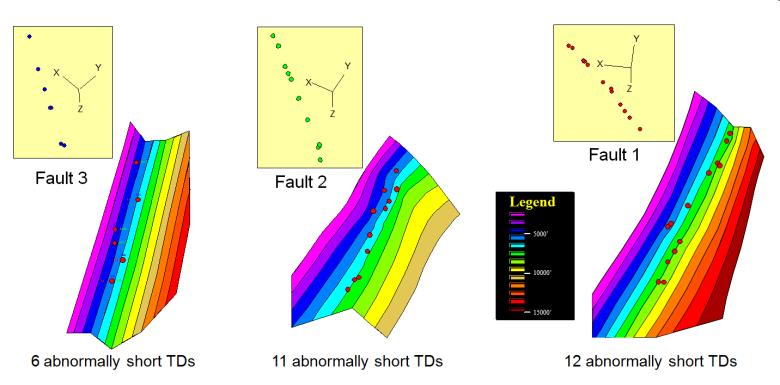
21 Angular patterns in MBPA The MBPA is telling us that: The fault cut-outs are at the right depths They cannot be interpreted as normal faults The beginning of a solution came from: Abnormal well terminations Mechanical failures led to stop 29 wells short of their objective
22 29 abnormal TDs (Total Depth) All of the abnormal TDs could be fitted on three well defined planes After Chatellier et al. 1999

23 North-South Cross-section Only wells with no faults C-44
24 North-South Cross-section Recognizing a blocky sand across the whole of the block has been essential to understanding the stratigraphy C-44 unit = catastrophic storm deposit Bars Channel Bars Channel C-44 In a few wells the C-44 tempestite is repeated but the facies above the unit are different

25 Why has everyone missed the repeats?

26 Map view of sedimentology in Block VLA-31

27 New main faults in VLA-31 block Injection well

28 Schematic cross-section Block VLA-31 Strike-Slip Icotea fault

29
30 Reactivated reverse faults (Example 1) Most important points: It could be very common but you have to be lucky to get a good example This first example gives a time frame for the fault activity SANTA BARBARA CARITO FURRIAL
31 3-D View SANTA BARBARA CARITO FURRIAL SANTA BARBARA CARITO FURRIAL

32 Nobody wanted to study the MUC-13 cores The white bands scared the sedimentologists away!

33

34 One fault system linking all missing sections Shallow fault in the Tertiary sand of every well

35 Schematic diagram of the proposed mechanism NNW SSE
36 Previous interpretation Normal Fault Interpretation
37 New interpretation Reverse Fault with missing section Reverse Fault Interpretation
38 Reactivated reverse faults (Example 2) Most important points: Problem with the hydrocarbon map (oil over gas ) Each well had one major missing section These faults were not seen on the 3-D seismic Fault plane dip and stratigraphy are oblique to each other
39 3-D View SANTA BARBARA CARITO FURRIAL SANTA BARBARA CARITO FURRIAL
40 Santa Barbara Field Note the NE dip of the top structure
41 N Missing sections in Santa Barbara Central Block Fault picks by F. Ruiz (stratigrapher) SBC-20 SBC-16 SBC-45 SBC-103 S Fault dip 43 Dip Projection


42 Fault plane Strike of beds j degree dip Fault plane generated during first phase of compression Oblique slip generated by second compression phase j2 S20 S69 S45 S16 Map of top Naricual (Sand)

 Upper Naricual Lower Naricual")
43 4 5 6 Schematic block diagram for Fault F103 beds with 14 dip F103 Carapita U Nar L Nar Fault F103 with 43 dip Cretaceous bird eyes view of beds below Fault plane (footwall expression) Upper Naricual Lower Naricual Cretaceous
44 Lateral movement along Fault (simplification) Viewed from the NE Beds with 14 dip towards NE Hanging wall Footwall Fault F dip towards NW
45

46 Missing Sections associated with Fault F103 Final view Missing sections

47 Oblique slip example Only the lateral displacement has been invoked
48 SBC-2 Repeat Formation Test RFT pressures Prof. ft PSI Fault Fault 2 Fault throw Well SBC-02 (West of the location map) Tectonic post hydrocarbon emplacement is reflected in the pressure trends Reverse faulting is interpreted from pressure data (despite a missing section)
49 Detachments and low angle backthrusts
50 Santa Barbara Field Bosque Seismic line Block 2 Block 1 X-section Block 3
51 Cross-section Block 3 W E

52 Projected well see to the right

53 3-D View SANTA BARBARA CARITO FURRIAL SANTA BARBARA CARITO FURRIAL

54 Top Naricual in Santa Barbara Study Area
55 Depth of fault intersections
56 Fault throw map

57 Bird s eye map of low angle fault
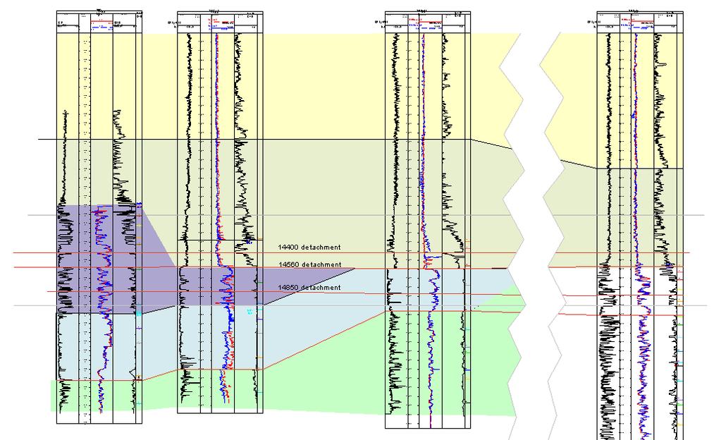
58 Pressure data gives some clues DESPEGUE TVD(ss) Horizontal PSI Despegue Detachment RFT SBC-96 (02-99) SBC-52 (08-96) SBC-61 (03-97)
59 Example from the Santa Barbara block 2 North South CARAPITA SHALES Intra-Carapita Marker A Intra-Carapita Marker A Nar Sup Nar Sup Nar Inf KT Section from 3-D modelling
60 Santa Barbara Structural Map Integration = Better map with engineers approval Klippe Flat Scar of decapitation to the North Scar of decapitation to the South Chatellier et al 2002
61 Decapitation and the hidden giant NE Repeat section Missing section Decapitation SW Carapita Naricual Superior Naricual Inferior Cretaceous Wells with relative poor production Calgary tower as a scale Modified after Chatellier et al 2002
62 Conclusions Missing sections not always linked to normal faults Look for: Missing sections at the same stratigraphic level Missing section at similar depth Reactivated faults (different bed and fault azimuths)
63 Potential Rewards Much better and reliable geological model Better development plan (e.g. Injection) Identify by-passed pays Potential for new discoveries It is worth challenging an old paradigm
64 Acknowledgements PDVSA for letting us present many of our findings Talisman Energy Inc. my present employer AAPG, especially Susan Nash Ken Molay for his help organizing this webinar
65 Challenging the Paradigm missing section = normal fault Implications for hydrocarbon exploration Jean-Yves Chatellier Talisman Energy Inc
Structural Style and Tectonic Evolution of the Nakhon Basin, Gulf of Thailand
 Structural Style and Tectonic Evolution of the Nakhon Basin, Gulf of Thailand Piyaphong Chenrai Petroleum Geoscience Program, Department of Geology, Faculty of Science, Chulalongkorn University, Bangkok
Quick Look Interpretation Techniques
 Quick Look Interpretation Techniques Odd Number of Contours A basic rule of contouring is that ALL contours on a continuous surface must close or end at the edge of the map. This rule seems so obvious
RELINQUISHMENT REPORT. License P1546 Block April 2009
 RELINQUISHMENT REPORT License P1546 Block 110-01 14 April 2009 Sherritt International Oil and Gas Limited 2000, 425-1 st street S.W., Calgary, Alberta Canada T2P 3L8 Telephone (403) 260-2900 Fax (403)
Bulletin of Earth Sciences of Thailand
 Quantitative Seismic Geomorphology of Early Miocene to Pleistocene Fluvial System of Northern Songkhla Basin, Gulf of Thailand Oanh Thi Tran Petroleum Geoscience Program, Department of Geology, Faculty
Vail et al., 1977b. AAPG 1977 reprinted with permission of the AAPG whose permission is required for further use.
 Well 5 Well 4 Well 3 Well 2 Well 1 Vail et al., 1977b AAPG 1977 reprinted with permission of the AAPG whose permission is required for further use. Well 5 Well 4 Well 3 Well 2 Well 1 Vail et al., 1977b
Answer sheet for question 1 Answer question 1 as soon as the sample arrives at your desk.
 EAS 233 Geologic structures. Final test. April 2012. 3 hours. Answer question 1 and 2 and three other questions. If you start more than the required number of questions, clearly delete the answers you
Geologic influence on variations in oil and gas production from the Cardium Formation, Ferrier Oilfield, west-central Alberta, Canada
 Geologic influence on variations in oil and gas production from the Cardium Formation, Ferrier Oilfield, west-central Alberta, Canada Marco Venieri and Per Kent Pedersen Department of Geoscience, University
Constrained Fault Construction
 Constrained Fault Construction Providing realistic interpretations of faults is critical in hydrocarbon and mineral exploration. Faults can act as conduits or barriers to subsurface fluid migration and
Study the architecture and processes responsible for deformation of Earth s crust. Folding and Faulting
 Crustal Deformation AKA Structural geology (adapted from Brunkel, 2012) Study the architecture and processes responsible for deformation of Earth s crust. Folding and Faulting How Rocks Deform: 4 Controls
Relinquishment Report for Licence P.1265, Block 12/28
 Relinquishment Report for Licence P.1265, Block 12/28 1. Licence Information Licence Number: P.1265 Licence Round: 23 rd Round Awarded 22 December 2005 Licence Type: Traditional Block Number(s): 12/28
Lab 7: STRUCTURAL GEOLOGY FOLDS AND FAULTS
 Lab 7: STRUCTURAL GEOLOGY FOLDS AND FAULTS This set of labs will focus on the structures that result from deformation in earth s crust, namely folds and faults. By the end of these labs you should be able
Bulletin of Earth Sciences of Thailand. A study of Reservoir Connectivity in the Platong Field, Pattani Basin, Gulf of Thailand. Hathairat Roenthon
 A study of Reservoir Connectivity in the Platong Field, Pattani Basin, Gulf of Thailand Hathairat Roenthon Petroleum Geoscience Program, Department of Geology, Faculty of Science, Chulalongkorn University,
Relinquishment Report. for. Licence P.272 Block 20/7a
 Relinquishment Report for Licence P.272 Block 20/7a February 2007 1 of 16 CONTENT 1 - Introduction 2 - Exploration Activities 2.1 - Purchase 130km2 of Aker 1999 survey 2.2 Reprocessing of 3D Aker data
MUHAMMAD S TAMANNAI, DOUGLAS WINSTONE, IAN DEIGHTON & PETER CONN, TGS Nopec Geological Products and Services, London, United Kingdom
 Geological and Geophysical Evaluation of Offshore Morondava Frontier Basin based on Satellite Gravity, Well and regional 2D Seismic Data Interpretation MUHAMMAD S TAMANNAI, DOUGLAS WINSTONE, IAN DEIGHTON
EAS 233 Geologic Structures and Maps Winter Miscellaneous practice map exercises. 1. Fault and separation:
 Miscellaneous practice map exercises 1. Fault and separation: With respect to Map 1, what are (a) the orientation of the fault, and (b) the orientation of bedding in the units cut by the fault. (c) Mark
Stress and Strain. Stress is a force per unit area. Strain is a change in size or shape in response to stress
 Geologic Structures Geologic structures are dynamically-produced patterns or arrangements of rock or sediment that result from, and give information about, forces within the Earth Produced as rocks change
Distortion Effects of Faults on Gravity Worm Strings Robin O Leary
 Distortion Effects of Faults on Gravity Worm Strings Robin O Leary Problem Can upward continued gravity anomaly worm strings be used as a tool to determine the dip direction of an offsetting structure
Integrated well log and 3-D seismic data interpretation for the Kakinada area of KG PG offshore basin
 IOSR Journal of Applied Geology and Geophysics (IOSR-JAGG) e-issn: 2321 0990, p-issn: 2321 0982.Volume 5, Issue 4 Ver. II (Jul. Aug. 2017), PP 01-05 www.iosrjournals.org Integrated well log and 3-D seismic
Bulletin of Earth Sciences of Thailand. Evaluation of the Petroleum Systems in the Lanta-Similan Area, Northern Pattani Basin, Gulf of Thailand
 Evaluation of the Petroleum Systems in the Lanta-Similan Area, Northern Pattani Basin, Gulf of Thailand Sirajum Munira Petroleum Geoscience Program, Department of Geology, Faculty of Science, Chulalongkorn
J.V. Herwanger* (Ikon Science), A. Bottrill (Ikon Science) & P. Popov (Ikon Science)
, A. Bottrill (Ikon Science) & P. Popov (Ikon Science)") 29829. One 4D geomechanical model and its many applications J.V. Herwanger* (Ikon Science), A. Bottrill (Ikon Science) & P. Popov (Ikon Science) Main objectives (i) Field case study demonstrating application
29829. One 4D geomechanical model and its many applications J.V. Herwanger* (Ikon Science), A. Bottrill (Ikon Science) & P. Popov (Ikon Science) Main objectives (i) Field case study demonstrating application
UNDERSTANDING GEOLOGIC M APS
 Name: Lab Section: work in groups, but each person turns in his/her own GEOSCIENCE 001 L AB UNDERSTANDING GEOLOGIC M APS Geologic maps are colorful and even beautiful, but they also contain an amazing
Fault growth & linkage
 Fault growth & linkage Important to understand fault growth, interaction & linkage Continental extension and basin formation Controls on subsurface fluid flow Hydrocarbon exploration & production Minerals
SAND DISTRIBUTION AND RESERVOIR CHARACTERISTICS NORTH JAMJUREE FIELD, PATTANI BASIN, GULF OF THAILAND
 SAND DISTRIBUTION AND RESERVOIR CHARACTERISTICS NORTH JAMJUREE FIELD, PATTANI BASIN, GULF OF THAILAND Benjawan KIinkaew Petroleum Geoscience Program, Department of Geology, Faculty of Science, Chulalongkorn
In this lab, we will study and analyze geologic maps from a few regions, including the Grand Canyon, western Wyoming, and coastal California.
 Name: Lab Section: work in groups, but each person turns in his/her own GEOSCIENCE 001 LAB UNDERSTANDING GEOLOGIC MAPS Geologic maps are colorful and even beautiful, but they also contain an amazing amount
Serica Energy (UK) Limited. P.1840 Relinquishment Report. Blocks 210/19a & 210/20a. UK Northern North Sea
 Limited. P.1840 Relinquishment Report. Blocks 210/19a & 210/20a. UK Northern North Sea") Serica Energy (UK) Limited P.1840 Relinquishment Report Blocks 210/19a & 210/20a UK Northern North Sea January 2013 1 Header Licence: P.1840 Round: Licence Type: 26th Round Traditional "Drill-or-Drop"
Serica Energy (UK) Limited P.1840 Relinquishment Report Blocks 210/19a & 210/20a UK Northern North Sea January 2013 1 Header Licence: P.1840 Round: Licence Type: 26th Round Traditional "Drill-or-Drop"
Structural Modelling of Inversion Structures: A case study on South Cambay Basin
 10 th Biennial International Conference & Exposition P 065 Structural Modelling of Inversion Structures: A case study on South Cambay Basin Dr. Mayadhar Sahoo & S.K Chakrabarti Summary The inversion in
Lecture Outline Friday March 2 thru Wednesday March 7, 2018
 Lecture Outline Friday March 2 thru Wednesday March 7, 2018 Questions? Lecture Exam Friday March 9, 2018 Same time, Same room Bring Pencils and WSU ID 50 question Multiple Choice, Computer Graded Interlude
Structural Geology Lab. The Objectives are to gain experience
 Geology 2 Structural Geology Lab The Objectives are to gain experience 1. Drawing cross sections from information given on geologic maps. 2. Recognizing folds and naming their parts on stereoscopic air
Course Title: Discipline: Geology Level: Basic-Intermediate Duration: 5 Days Instructor: Prof. Charles Kluth. About the course: Audience: Agenda:
 Course Title: Structural Geology Discipline: Geology Level: Basic-Intermediate Duration: 5 Days Instructor: Prof. Charles Kluth About the course: This course covers the basic ideas of structural geometry
Chapter 15 Structures
 Chapter 15 Structures Plummer/McGeary/Carlson (c) The McGraw-Hill Companies, Inc. TECTONIC FORCES AT WORK Stress & Strain Stress Strain Compressive stress Shortening strain Tensional stress stretching
Licence Relinquishment Report. P.1400 Block 12/30. First Oil Expro Ltd
 Licence Relinquishment Report P.1400 Block 12/30 First Oil Expro Ltd December 2007 Seaward Production Licence P.1400, Block 12/30 Block 12/30 was awarded 100% to Reach Exploration North Sea Ltd as a promote
DATA ANALYSIS AND INTERPRETATION
 III. DATA ANALYSIS AND INTERPRETATION 3.1. Rift Geometry Identification Based on recent analysis of modern and ancient rifts, many previous workers concluded that the basic structural unit of continental
High Resolution Field-based Studies of Hydrodynamics Examples from the North Sea
 High Resolution Field-based Studies of Hydrodynamics Examples from the North Sea Stephen O Connor 1, Richard Swarbrick 2 and Sam Green 1 1 Ikon GeoPressure, Durham, UK 2 Swarbrick Geopressure Consultancy,
Carboniferous Stoddart Group: An integrated approach
 Carboniferous Stoddart Group: An integrated approach Abu Yousuf*, Department of Geoscience, University of Calgary, Calgary, Alberta yousufabu@hotmail.com and Charles M. Henderson, Department of Geoscience,
T-z profiles can elucidate the kinematic history of normal faults (i.e. fault nucleation, growth, and/or
 GSA Data Repository 2018026 Phillips et al., 2018, Determining the three-dimensional geometry of a dike swarm and its impact on later rift geometry using seismic reflection data: Geology, https://doi.org/10.1130/g39672.1.
Geologic Considerations of Shallow SAGD Caprock; Seal Capacity, Seal Geometry and Seal Integrity, Athabasca Oilsands, Alberta Canada
 Geologic Considerations of Shallow SAGD Caprock; Seal Capacity, Seal Geometry and Seal Integrity, Athabasca Oilsands, Alberta Canada Gordon T. Stabb, Michael Webb Durando Resources Corp, Suncor Energy
3D curvature attributes: a new approach for seismic interpretation
 first break volume 26, April 2008 special topic 3D curvature attributes: a new approach for seismic interpretation Pascal Klein, Loic Richard, and Huw James* (Paradigm) present a new method to compute
Structural Geology Lab. The Objectives are to gain experience
 Geology 2 Structural Geology Lab The Objectives are to gain experience 1. Drawing cross sections from information given on geologic maps. 2. Recognizing folds and naming their parts on stereoscopic air
Reservoir Modelling of a Bioclastic Calcarenite Complex on Favignana, Southern Italy: The Application of Multi-point Statistics*
 Reservoir Modelling of a Bioclastic Calcarenite Complex on Favignana, Southern Italy: The Application of Multi-point Statistics* Robert Kil 1 and Andrea Moscariello 2,3 Search and Discovery Article #50548
Crags, Cracks, and Crumples: Crustal Deformation and Mountain Building
 Crags, Cracks, and Crumples: Crustal Deformation and Mountain Building Updated by: Rick Oches, Professor of Geology & Environmental Sciences Bentley University Waltham, Massachusetts Based on slides prepared
depression above scarp scarp
 1 LAB 1: FIELD TRIP TO McKINLEYVILLE AND MOUTH OF THE MAD RIVER OBJECTIVES: a. to look at geomorphic and geologic evidence for large scale thrust-faulting of young sediments in the Humboldt Bay region
Jocelyn Karen Campbell
 THE UNCERTAINTIES IN ASSESSING THE IMPACT OF REGIONAL SEISMICITY AT THE WIL SITE Statement of Evidence by Jocelyn Karen Campbell A CANTERBURY FAULTS coded by type CHARACTERISTICS OF THRUST FAULTS IN CANTERBURY
Abstract. *Modified from extended abstract prepared for presentation at AAPG Annual Convention, Calgary, Alberta, June 19-22, 2005
 The Jurassic-Cretaceous North Sea Rift Dome and Associated Basin Evolution* By Ole Graversen 1 Search and Discovery Article #30040 (2006) Posted February 19, 2006 *Modified from extended abstract prepared
Using structural validation and balancing tools to aid interpretation
 Using structural validation and balancing tools to aid interpretation Creating a balanced interpretation is the first step in reducing the uncertainty in your geological model. Balancing is based on the
NORTHEAST EL HAMD BLOCK
 NORTHEAST EL HAMD BLOCK NORTHEAST EL HAMD BLOCK LOCATION : The block is locating in the eastern side of the central part of the Gulf of Suez basin west and south of Belayim fields. NORTHEAST EL HAMD BLOCK
Mapping Magnetic Lineaments in the Foothills of Northeastern British Columbia using 2-D Wavelet Transform
 Mapping Magnetic Lineaments in the Foothills of Northeastern British Columbia using 2-D Wavelet Transform Hassan Hassan* GEDCO, Calgary, Alberta, Canada hassan@gedco.com Abstract Summary This work describes
Structural Style in the Peel Region, NWT and Yukon
 Structural Style in the Peel Region, NWT and Yukon Adriana Taborda* Husky Energy and University of Calgary, Calgary, AB Adriana.Taborda@huskyenergy.ca and Deborah Spratt University of Calgary, Calgary,
Assignment #5-7: Geology
 Assignment #5-7: Geology Name: 1. "Geological processes operating at the present time are the same processes that have operated in the past" is a statement of: A. the Principle of Cross-cutting Relationships
Provided by Tasa Graphic Arts, Inc. for An Introduction to Structural Methods DVD-ROM
 Provided by Tasa Graphic Arts, Inc. for An Introduction to Structural Methods DVD-ROM http://www.tasagraphicarts.com/progstruct.html AN INTRODUCTION TO STRUCTURAL METHODS - DETAILED CONTENTS: (Navigate
Sedimentary Cycle Best Practice: Potential Eo-Oligocene Sediments in Western Indonesia*
 Sedimentary Cycle Best Practice: Potential Eo-Oligocene Sediments in Western Indonesia* Mellinda Arisandy 1 and I Wayan Darma 1 Search and Discovery Article #11008 (2017)** Posted November 6, 2017 *Adapted
A comparison of structural styles and prospectivity along the Atlantic margin from Senegal to Benin. Peter Conn*, Ian Deighton* & Dario Chisari*
 A comparison of structural styles and prospectivity along the Atlantic margin from Senegal to Benin Overview Peter Conn*, Ian Deighton* & Dario Chisari* * TGS, Millbank House, Surbiton, UK, KT6 6AP The
Geology 101 Lab Worksheet: Geologic Structures
 Name: Geology 101 Lab Worksheet: Geologic Structures Refer to the Geologic Structures Lab for the information you need to complete this worksheet (http://commons.wvc.edu/rdawes/g101ocl/labs/structurelab.html).
Distinguished Lecturer David A. Ferrill. Sponsored by AAPG Foundation
 Distinguished Lecturer David A. Ferrill Sponsored by AAPG Foundation AAPG Membership Information Benefits: Monthly Receipt of AAPG Explorer & AAPG Bulletin Discounts on Books and Other Publications Registration
Earth Science, (Tarbuck/Lutgens) Chapter 10: Mountain Building
 Chapter 10: Mountain Building") Earth Science, (Tarbuck/Lutgens) Chapter 10: Mountain Building 1) A(n) fault has little or no vertical movements of the two blocks. A) stick slip B) oblique slip C) strike slip D) dip slip 2) In a(n) fault,
Earth Science, (Tarbuck/Lutgens) Chapter 10: Mountain Building 1) A(n) fault has little or no vertical movements of the two blocks. A) stick slip B) oblique slip C) strike slip D) dip slip 2) In a(n) fault,
P1794 Relinquishment Document Blocks 22/2d, 22/3c & 22/4c
 P1794 Relinquishment Document Blocks 22/2d, 22/3c & 22/4c 1. Licence Information Licence Number: P1794 Licence Round: 26 th Round- Awarded January 2011 Licence Type: Traditional; (Drill or Drop within
Sequence Stratigraphy of the Upper Cretaceous Niobrara Formation, A Bench, Wattenberg Field, Denver Julesburg Basin, Colorado*
 Sequence Stratigraphy of the Upper Cretaceous Niobrara Formation, A Bench, Wattenberg Field, Denver Julesburg Basin, Colorado* Lisa E. Remington LaChance 1 and Mark C. Robinson 1 Search and Discovery Article
Kilometre-Scale Uplift of the Early Cretaceous Rift Section, Camamu Basin, Offshore North-East Brazil*
 Kilometre-Scale Uplift of the Early Cretaceous Rift Section, Camamu Basin, Offshore North-East Brazil* Iain Scotchman 1 and Dario Chiossi 2 Search and Discovery Article #50183 (2009) Posted May 20, 2009
Case Study of the Structural and Depositional-Evolution Interpretation from Seismic Data*
 Case Study of the Structural and Depositional-Evolution Interpretation from Seismic Data* Yun Ling 1, Xiangyu Guo 1, Jixiang Lin 1, and Desheng Sun 1 Search and Discovery Article #20143 (2012) Posted April
Know Before You Go. Steve O Connor. Bryony Youngs. How GeoPrediction helps with Production Optimization and Assessing the Size of the Prize
 Know Before You Go How GeoPrediction helps with Production Optimization and Assessing the Size of the Prize Steve O Connor Global Technical Lead, Geopressure Bryony Youngs Reservoir Portfolio Development
The Stability Of Fault Systems In The South Shore Of The. St. Lawrence Lowlands Of Québec Implications For Shale Gas Development
 The Stability Of Fault Systems In The South Shore Of The St. Lawrence Lowlands Of Québec Implications For Shale Gas Development John Brodylo, Jean-Yves Chatellier,Guillaume Matton & Michel Rheault Copyright
The Stratigraphic Trap in the Benchamas Field Pattani Basin, Gulf of Thailand
 The Stratigraphic Trap in the Benchamas Field Pattani Basin, Gulf of Thailand Jurairat Buangam Petroleum Geoscience Program, Department of Geology, Faculty of Science, Chulalongkorn University, Bangkok
Geometric attributes such as coherence and curvature are
 SATINDER CHOPRA, Arcis Seismic Solutions, Calgary, Canada KURT J. MARFURT, University of Oklahoma, Norman, USA Geometric attributes such as coherence and curvature are commonly used for mapping structural
GEOLOGIC MAPS PART II
 EARTH AND ENVIRONMENT THROUGH TIME LABORATORY - EES 1005 LABORATORY FIVE GEOLOGIC MAPS PART II Introduction Geologic maps of orogenic belts are much more complex than maps of the stable interior. Just
Earthquakes and Seismotectonics Chapter 5
 Earthquakes and Seismotectonics Chapter 5 What Creates Earthquakes? The term Earthquake is ambiguous: Applies to general shaking of the ground and to the source of the shaking We will talk about both,
Play fairway mapping in the Northeast Atlantic Margin Comparison between mature and immature basins. David Mudge, Joanne Cranswick
 Play fairway mapping in the Northeast Atlantic Margin Comparison between mature and immature basins David Mudge, Joanne Cranswick Contents Ternan North Sea Play fairway mapping Tertiary case study Northeast
Southern Songkhla Basin, Gulf of Thailand
 Architecture and Depositional Environment of Fluvial Systems of Southern Songkhla Basin, Gulf of Thailand Toan Manh Do Petroleum Geoscience Program, Department of Geology, Faculty of Science, Chulalongkorn
Controls on clastic systems in the Angoche basin, Mozambique: tectonics, contourites and petroleum systems
 P2-2-13 Controls on clastic systems in the Angoche basin, Mozambique: tectonics, contourites and petroleum systems Eva Hollebeek, Olivia Osicki, Duplo Kornpihl Schlumberger, London, UK Introduction Offshore
Relinquishment Report
 Relinquishment Report Licence P1403 Block 13/22d Chevron North Sea Limited Korean National Oil Company Chevron North Sea Limited December 2009 1 SYNOPSIS... 3 2 INTRODUCTION. 3 2.1 Licence Terms.. 3 2.2
Description of faults
 GLG310 Structural Geology Description of faults Horizontal stretch Crustal thickness Regional elevation Regional character Issues Normal Thrust/reverse Strike-slip >1 1 in one direction and < 1 in
Fault seal analysis: a regional calibration Nile delta, Egypt
 International Research Journal of Geology and Mining (IRJGM) (2276-6618) Vol. 3(5) pp. 190-194, June, 2013 Available online http://www.interesjournals.org/irjgm Copyright 2013 International Research Journals
Trapping Mechanisms along North Similan and Lanta Trends, Pattani Basin, Gulf of Thailand
 Trapping Mechanisms along North Similan and Lanta Trends, Pattani Basin, Gulf of Thailand Piyaporn Aukkanit Petroleum Geoscience Program, Department of Geology, Faculty of Science, Chulalongkorn University,
Name. GEOL.5220 Structural Geology Faults, Folds, Outcrop Patterns and Geologic Maps. I. Properties of Earth Materials
 I. Properties of Earth Materials GEOL.5220 Structural Geology Faults, Folds, Outcrop Patterns and Geologic Maps Name When rocks are subjected to differential stress the resulting build-up in strain can
Learning goals - January 16, Describe the geometry of a fault (1) orientation of the plane (strike and dip) (2) slip vector
 orientation of the plane (strike and dip) (2) slip vector") Learning goals - January 16, 2012 You will understand how to: Describe the geometry of a fault (1) orientation of the plane (strike and dip) (2) slip vector Understand concept of slip rate and how it is
Learning goals - January 16, 2012 You will understand how to: Describe the geometry of a fault (1) orientation of the plane (strike and dip) (2) slip vector Understand concept of slip rate and how it is
The characteristics of fracture dense belt and its effect on hydrocarbon. accumulation in the Putaohua reservoir, Xingnan oilfield, Daqing
 The characteristics of fracture dense belt and its effect on hydrocarbon accumulation in the Putaohua reservoir, Xingnan oilfield, Daqing 1 Y.Y. YIN,2 Zh. Luo, 3Q. Li, 4X.R. Wang 1 School of Energy Resources,
Search and Discovery Article #20097 (2011) Posted January 31, 2011
 Posted January 31, 2011") Integrated Geological and Engineering Studies in Support of Producing Light Oil from a Frozen Reservoir: A Case Study from Umiat Oil Field, Northern Alaska* C. Hanks 1, J. Mongrain 2, A. Dandekar 2, P.
Integrated Geological and Engineering Studies in Support of Producing Light Oil from a Frozen Reservoir: A Case Study from Umiat Oil Field, Northern Alaska* C. Hanks 1, J. Mongrain 2, A. Dandekar 2, P.
Crustal Deformation. Earth Systems 3209
 Crustal Deformation Earth Systems 3209 Crustal Deformation pg. 415 Refers to all changes in the original form and/or size of a rock body. May also produce changes in the location and orientation of rocks.
GEO4240: 3D Seismic Interpretation Project
 GEO4240: 3D Seismic Interpretation Project STRUCTURAL GEOLOGY PROJECT: Jura reservoir in the Troll Field (block 31/2) Phase 1: Geological framework (study key literature). Interpret 2D seismic line SG8043-402
Modeling Lateral Accretion in the McMurray Formation at Grizzly Oil Sands Algar Lake SAGD Project
 Modeling Lateral Accretion in the McMurray Formation at Algar Lake SAGD Project Duncan Findlay 1, Thomas Nardin 1, Andrew Couch 2, Alex Wright 1 1 ULC, 2 EON Introduction Laterally accreting channel systems
Seismic stratigraphy, some examples from Indian Ocean, interpretation of reflection data in interactive mode
 Seismic stratigraphy, some examples from Indian Ocean, interpretation of reflection data in interactive mode K. S. Krishna National Institute of Oceanography, Dona Paula, Goa-403 004. krishna@nio.org Seismic
Sequence Stratigraphy. Historical Perspective
 Sequence Stratigraphy Historical Perspective Sequence Stratigraphy Sequence Stratigraphy is the subdivision of sedimentary basin fills into genetic packages bounded by unconformities and their correlative
Pre-Feasibility Report
 Pre-Feasibility Report Project Details: The Block MB-OSN-2005/1 is a Saurashtra shallow water block situated between GS-OSN- 2003/1(NELP-V) in the west, C-37/C-43 PEL in the east and Saurashtra - Dahanu
Downloaded 10/10/13 to Redistribution subject to SEG license or copyright; see Terms of Use at
 Characterizing a fault-zone and associated fractures using lab experiments and attribute-based seismic analysis: an example from Woodford Shale, Anadarko basin, Oklahoma Zonghu Liao*, Ze ev Reches, and
Seismic Attributes and Their Applications in Seismic Geomorphology
 Academic article Seismic Attributes and Their Applications in Seismic Geomorphology Sanhasuk Koson, Piyaphong Chenrai* and Montri Choowong Department of Geology, Faculty of Science, Chulalongkorn University,
2D cross-section restoration in the onshore Nile Delta, Egypt. Nico Hübner (DEA Deutsche Erdoel AG)
") 2D cross-section restoration in the onshore Nile Delta, Egypt Nico Hübner (DEA Deutsche Erdoel AG) Introduction A 2D cross-section restoration was carried out as part of a hydrocarbon play assessment
2D cross-section restoration in the onshore Nile Delta, Egypt Nico Hübner (DEA Deutsche Erdoel AG) Introduction A 2D cross-section restoration was carried out as part of a hydrocarbon play assessment
Search and Discovery Article #40536 (2010) Posted June 21, 2010
 Posted June 21, 2010") Modern Examples of Mass Transport Complexes, Debrite and Turbidite Associations: Geometry, Stratigraphic Relationships and Implications for Hydrocarbon Trap Development* Fabiano Gamberi 1, Marzia Rovere
Modern Examples of Mass Transport Complexes, Debrite and Turbidite Associations: Geometry, Stratigraphic Relationships and Implications for Hydrocarbon Trap Development* Fabiano Gamberi 1, Marzia Rovere
Lecture # 6. Geological Structures
 1 Lecture # 6 Geological Structures ( Folds, Faults and Joints) Instructor: Dr. Attaullah Shah Department of Civil Engineering Swedish College of Engineering and Technology-Wah Cantt. 2 The wavy undulations
Relinquishment Report
 Relinquishment Report Licence P.089 Block 22/15a 2 nd Round Traditional Licence Award (Operator): 100.0% Disclaimer No representation or warranty, express or implied, is or will be made in relation to
Fault History analysis in Move
 Fault History analysis in Move The new Fault History plot in Move provides a method to conduct a quick-look analysis of the evolution of faults through time. By restoring the vertical displacement of a
PROBLEM SET #X. 2) Draw a cross section from A-A using the topographic profile provided on page 3.
 Draw a cross section from A-A using the topographic profile provided on page 3.") PROBLEM SET #X PART A: The geologic map on page 3 is from an area consisting of faulted Miocene sedimentary rocks. There are two major faults exposed here: the Rattlesnake fault and the Jackrabbit fault.
PROBLEM SET #X PART A: The geologic map on page 3 is from an area consisting of faulted Miocene sedimentary rocks. There are two major faults exposed here: the Rattlesnake fault and the Jackrabbit fault.
APPENDIX C GEOLOGICAL CHANCE OF SUCCESS RYDER SCOTT COMPANY PETROLEUM CONSULTANTS
 APPENDIX C GEOLOGICAL CHANCE OF SUCCESS Page 2 The Geological Chance of Success is intended to evaluate the probability that a functioning petroleum system is in place for each prospective reservoir. The
The Maule Field: An Economic Small Field Development
 AUSTRALIA ARGENTINA CANADA EGYPT NORTH SEA U.S. CENTRAL U.S. GULF The Maule Field: An Economic Small Field Development J. Pyle*, K. Koster, G. Barker and P. Rose Introduction 2 Eocene penetrations with
Structural Interpretation of Dipmeter Log A Case Study from Baramura Field of Tripura
 Structural Interpretation of Dipmeter Log A Case Study from Baramura Field of Tripura T. Chattopadhyay* and D. K. Ghosh Petropysics Division, KDMIPE, ONGC, Dehradun India Summary Dipmeter logging tool
Azimuth with RH rule. Quadrant. S 180 Quadrant Azimuth. Azimuth with RH rule N 45 W. Quadrant Azimuth
 30 45 30 45 Strike and dip notation (a) N30 E, 45 SE ("Quadrant"): the bearing of the strike direction is 30 degrees east of north and the dip is 45 degrees in a southeast (SE) direction. For a given strike,
Distribution of Overpressure and its Prediction in Saurashtra Dahanu Block, Western Offshore Basin, India*
 Distribution of Overpressure and its Prediction in Saurashtra Dahanu Block, Western Offshore Basin, India* Kanak R. Nambiar 1, B.K. Singh 2, R.N. Goswami 2, and K.R.K. Singh 2 Search and Discovery Article
Integrated Fracture Identification with Z-VSP and Borehole Images: A study from Cambay Basin
 P-124 Integrated Fracture Identification with Z-VSP and Borehole Images: A study from Cambay Basin Sattwati Dey, Jubilant Energy; Chandramani Shrivastva, Schlumberger; Sreemanti Gijare*, Schlumberger;
How to Build a Mountain and other Geologic Structures. But first a short review
 How to Build a Mountain and other Geologic Structures But first a short review Where do we see deep earthquakes? What is happening there? What can happen at a plate boundary? 1. Plates can move apart
Lab 4: Structures and Geologic Maps
 Key Questions: GEOL 1311 Earth Science Lab 4 Structures and Geologic Maps What shapes do rock bodies take in the Earth? How do two-dimensional visualizations of the Earth, such as maps and cross-sections
Aptian/Albian Reservoir Development in the Jeanne d Arc Basin, Offshore Eastern Canada
 Aptian/Albian Reservoir Development in the Jeanne d Arc Basin, Offshore Eastern Canada Jonathan Marshall, Statoil Canada Ltd. Calgary, Alberta, Canada. jomars@statoil.com Introduction: The Jeanne d Arc
GEOLOGY MEDIA SUITE Chapter 13
 UNDERSTANDING EARTH, SIXTH EDITION GROTZINGER JORDAN GEOLOGY MEDIA SUITE Chapter 13 Earthquakes 2010 W.H. Freeman and Company Three different types of seismic waves are recorded by seismographs Key Figure
FOLDS AND THRUST SYSTEMS IN MASS TRANSPORT DEPOSITS
 FOLDS AND THRUST SYSTEMS IN MASS TRANSPORT DEPOSITS G.I Aslop, S. Marco, T. Levi, R. Weinberger Presentation by Aaron Leonard INTRODUCTION Examine fold and thrust geometries associated with downslope movement