IV. Environmental Impact Analysis E. Geology and Soils
|
|
|
- Alaina Bryant
- 5 years ago
- Views:
Transcription
1 IV. Environmental Impact Analysis E. Geology and Soils 1. Introduction This section of the Draft EIR provides an analysis of the Project s potential impacts with regard to geology and soils. The analysis includes an evaluation of potential geologic hazards associated with fault rupture, seismic ground shaking, seismic-related ground failure (e.g., liquefaction), landslides, geologic unit and soil stability, and expansive and corrosive soils. The analysis is based on a review of California regulatory requirements, requirements, and several technical reports prepared for the Project, including the Soils and Geology Report to Support the Environmental Impact Report Proposed Art-Center College of Design Master Plan (Geotechnical Report) prepared by Geotechnologies, Inc. (February 7, 2017), the Fault Rupture Hazard Study, ArtCenter South Campus, Pasadena, California (Fault Rupture Study) prepared by Shannon & Wilson, Inc. (August 3, 2017), the Review of Fault Rupture Hazard Study Report prepared by Geotechnologies, Inc. (September 15, 2017). These technical reports are included as Appendix F of this Draft EIR. 2. Environmental Setting a. Regulatory Framework (1) State of California (a) Alquist Priolo Earthquake Fault Zoning Act The Alquist Priolo Earthquake Fault Zoning Act (Public Resources Code Section 2621) was enacted by the State of California in 1972 to address the hazard of surface faulting to structures for human occupancy. 1 The Alquist Priolo Earthquake Fault Zoning Act was enacted in response to the 1971 San Fernando Earthquake, which was associated with extensive surface fault ruptures that damaged homes, commercial buildings, and other structures. The primary purpose of the Alquist Priolo Earthquake Fault Zoning Act is to 1 The Alquist Priolo Earthquake Fault Zoning Act was originally entitled the Alquist Priolo Geologic Hazards Zone Act. Page IV.E-1
2 prevent the construction of buildings intended for human occupancy on the surface traces of active faults. The Alquist Priolo Earthquake Fault Zoning Act is also intended to provide citizens with increased safety and to minimize the loss of life during and immediately following earthquakes by facilitating seismic retrofitting to strengthen buildings against ground shaking. The Alquist Priolo Earthquake Fault Zoning Act requires the State Geologist to establish regulatory zones, known as Earthquake Fault Zones, around the surface traces of active faults and to issue appropriate maps to assist cities and counties in planning, zoning, and building regulation functions. Maps are distributed to all affected cities and counties for the controlling of new or renewed construction and are required to sufficiently define potential surface rupture or fault creep. The State Geologist is charged with continually reviewing new geologic and seismic data, revising existing zones, and delineating additional Earthquake Fault Zones when warranted by new information. Local agencies must enforce the Alquist Priolo Earthquake Fault Zoning Act in the development permit process, where applicable, and may be more restrictive than State law requires. According to the Alquist Priolo Earthquake Fault Zoning Act, before a project can be permitted, cities and counties shall require a geologic investigation for development within identified Alquist Priolo earthquake fault zones, prepared by a licensed geologist, to demonstrate that buildings will not be constructed across active faults identified by the State Geologist. If an active fault is found, a structure for human occupancy cannot be placed over the trace of the fault and must be set back a minimum of 50 feet. The Alquist Priolo Earthquake Fault Zoning Act and its regulations are presented in California Department of Conservation, California Geological Survey, Special Publication 42, Fault-Rupture Hazard Zones in California. (b) Seismic Safety Act The California Seismic Safety Commission was established by the Seismic Safety Act in 1975 with the intent of providing oversight, review, and recommendations to the Governor and State Legislature regarding seismic issues. 2 The Commission s name was changed to Alfred E. Alquist Seismic Safety Commission in Since its establishment, the Commission has adopted several documents based on recorded earthquakes, including: Alfred E. Alquist California Seismic Safety Commission, History and Responsibilities, gov/about.html, accessed February 27, Alfred E. Alquist Seismic Safety Commission, Publications, accessed February 27, Page IV.E-2
3 Research and Implementation Plan for Earthquake Risk Reduction in California 1995 to 2000, report dated December 1994; Seismic Safety in California s Schools, Findings and Recommendations on Seismic Safety Policies and Requirements for Public, Private, and Charter Schools, report dated December 2004; Findings and Recommendations on Hospital Seismic Safety, report dated November 2001; and Commercial Property Owner s Guide to Earthquakes Safety, report dated October (c) Seismic Hazards Mapping Act In order to address the effects of strong ground shaking, liquefaction, landslides, and other ground failures due to seismic events, the State of California passed the Seismic Hazards Mapping Act of 1990 (Public Resources Code Sections ). Under the Seismic Hazards Mapping Act, the State Geologist is required to delineate seismic hazard zones. Cities and counties must regulate certain development projects within these zones until the geologic and soil conditions of the project site are investigated and appropriate mitigation measures, if any, are incorporated into development plans. The State Mining and Geology Board provides additional regulations and policies to assist municipalities in preparing the Safety Element of their General Plan and encourage land use management policies and regulations to reduce and mitigate those hazards to protect public health and safety. Under Public Resources Code Section 2697, cities and counties shall require, prior to the approval of a project located in a seismic hazard zone, a geotechnical report defining and delineating any seismic hazard. Each city or county shall submit one copy of each geotechnical report, including mitigation measures, to the State Geologist within 30 days of its approval. Public Resources Code Section 2698 does not prevent cities and counties from establishing policies and criteria which are stricter than those established by the State Mining and Geology Board. State publications supporting the requirements of the Seismic Hazards Mapping Act include the California Geological Survey Special Publication 117A, Guidelines for Evaluating and Mitigating Seismic Hazards in California, and the Special Publication 118, Recommended Criteria for Delineating Seismic Hazard Zones in California. 4,5 The 4 5 California Geological Survey, Special Publication 117A, Guidelines for Evaluating and Mitigating Seismic Hazards in California, California Geological Survey, Special Publication 118, Recommended Criteria for Delineating Seismic Hazard Zones in California, May 1992 and revised April Page IV.E-3
4 objectives of Special Publication 117A are to assist in the evaluation and mitigation of earthquake related hazards for projects within designated zones of required investigations and to promote uniform and effective statewide implementation of the evaluation and mitigation elements of the Seismic Hazards Mapping Act. Special Publication 118 implements the requirements of the Seismic Hazards Mapping Act in the production of Probabilistic Seismic Hazard Maps for the state. (d) California Building Standards Code The California Building Standards Code (California Code of Regulations, Title 24) is a compilation of building standards, including seismic safety standards for new buildings. The California Building Standards Code is based on building standards that have been adopted by state agencies without change from a national model code; building standards that have been adopted and adapted from the national model code to meet California conditions; and building standards, authorized by the California legislature, that constitute extensive additions not covered by the model codes that have been adopted to address particular California concerns. 6 Given California s susceptibility to seismic events, the seismic standards within the California Building Standards Code are among the strictest in the world. The California Building Standards Code includes provisions for demolition and construction, as well as regulations regarding building foundations and soil types. The California Building Standards Code applies to all occupancies in California, except where stricter standards have been adopted by local agencies. The California Building Standards Code is published on a triennial basis, and supplements and errata can be issued throughout the cycle. Specifically, the California Building Code (CBC) is Part 2 of the thirteen parts of the triennial California Building Standards Code. The 2016 edition of the CBC became effective on January 1, 2017 and incorporates by adoption the 2015 edition of the International Building Code of the International Code Council, with California amendments. 7 The 2016 CBC incorporates the latest seismic design standards for structural loads and materials as well as provisions from the National Earthquake Hazards Reduction Program to mitigate losses from an earthquake and provide for the latest in earthquake safety. As discussed below, CBC building and seismic safety regulations have been adopted by the. As such, the California Building Code forms the basis of the compliance and permitting processes at the. 6 7 California Building Standards Commission, Information About the Codes, accessed February 27, California Code of Regulations, Title 24, Part 2, California Building Code. Page IV.E-4
5 (2) (a) General Plan Safety Element The General Plan Safety Element, which was adopted in October 2002, addresses public safety risks due to natural hazards, including seismic events and geologic conditions, and sets forth guidance for emergency response during disasters. The Technical Background Report to the 2002 Safety Element also provides maps of designated areas of faults and zones, seismicity, earthquakes, and other hazards in the City and region. The following policies regarding seismic hazards are relevant to the Project: Policy S-1: The City will monitor development or re-development within the Fault Hazard Management Zones identified for both the Sierra Madre and Raymond faults. Policy S-2: The City will ensure that current geologic knowledge and Statecertified professional review are incorporated into the design, planning, and construction states of a project, and that site-specific data are applied to each project. Policy S-3: The City will strive to ensure that the design of new, and the performance of existing structures address the appropriate earthquake hazards. Policy S-7: The City will educate the public on the hazards that can pose a risk to the City and its residents, and will describe loss reduction strategies that can be used to mitigate the specific hazards identified. The following policies regarding geologic hazards are relevant to the Project: Policy G-1: Whenever possible, mitigation of geologic hazards will be conducted without violating the property owners rights to modify or improve their investment, along with preserving the aesthetic or natural conditions of the area through minimal grading. When these goals are in conflict, protection of life and property will take precedence. Policy G-2: The City will continue to participate in regional programs designed to protect the groundwater resources of the Raymond Basin while protecting the area from the hazard of regional ground subsidence. Page IV.E-5
6 (b) City Adoption of the California Building Code The adopts the CBC for all of its construction-related activities. 8 The Building and Safety Division of the Pasadena Planning & Community Development Department is responsible for implementing the provisions of the California Building Code, which is discussed above, and manages code compliance and permitting processes. 9 b. Existing Conditions (1) Regional Geology The Los Angeles Basin is a seismically active area in southern California located in the northern portion of the Peninsular Ranges geomorphic province and is a northwesttrending alluviated lowland plain, sometimes called the Coastal Plain of Los Angeles. 10 The Peninsular Ranges are characterized by northwest-trending blocks of mountain ridges and sediment-floored valleys. The dominant geologic structural features are northwest trending fault zones that either die out to the northwest or terminate at east-trending reverse faults that form the southern margin of the Transverse Ranges. 11 Furthermore, the Los Angeles Basin is filled with sedimentation thousands of feet thick and is structurally influenced by thrusting fault blocks and strike slip fault expressions trending northwest. The Hillside Campus and South Campus are located near the northeastern boundary of the Los Angeles Basin. Both campuses are located in the Transverse Ranges Geomorphic Province. The Transverse Ranges are characterized by roughly east-west trending mountains and the northern and southern boundaries are formed by reverse fault scarps. The convergent deformational features of the Transverse Ranges are a result of north-south shortening due to plate tectonics. This has resulted in local folding and uplift of the mountains along with the propagation of thrust faults (including blind thrusts). The intervening valleys have been filled with sediments derived from the bordering mountains. Specifically, the Transverse Ranges Southern Boundary Fault System encompasses reverse, oblique-slip, and strike-slip faults and extends for more than approximately 124 miles along the southern edge of the Transverse Ranges, including the , Technical Background Report to the 2002 Safety Element., Planning & Community Development, Building & Safety, planning/buildingservices/, accessed February 27, U.S. Department of the Interior, Geology of the Los Angeles Basin, California an Introduction, Geological Survey Professional Paper 420-A, U.S. Department of the Interior, Geology of the Los Angeles Basin, California an Introduction, Geological Survey Professional Paper 420-A, Page IV.E-6
7 Hollywood, Raymond, Anacapa Dume, Malibu Coast, Santa Cruz Island, and Santa Rosa Island Faults. Specific to the area surrounding the South Campus, regional geologic maps show the South Campus to be underlain by Quaternary alluvial fan deposits derived from upland areas to the north. 12 These old alluvial fan deposits overlie bedrock Miocene age Topanga Group bedrock and Mesozoic age diorite bedrock. The Topanga Group is a sedimentary bedrock that typically consists of sandstone, siltstone, and conglomerate, and the diorite is an igneous bedrock. 13 The Hillside Campus and South Campus are located within the boundaries of the Raymond Basin within the broader San Gabriel Valley. The Raymond Basin is bounded by the Raymond Fault escarpment to the south, the San Gabriel Mountains to the north, the San Rafael Hills and Repetto Hills to the west, the Puente Hills to the south, and the San Jose Hills to the east. The Raymond Fault escarpment interrupts the valley floor due to the active faulting of the Raymond Fault, which has resulted in an abrupt change in topographic relief (i.e., up to 150 feet) and is characterized by geomorphic features related to the active faulting. (2) Regional Faulting and Seismicity Based on criteria established by the California Division of Mines and Geology (CDMG) now called the California Geological Survey (CGS), faults may be categorized as active, potentially active, or inactive. Active faults are those that show evidence of surface displacement within the last 11,000 years (i.e., Holocene-age). Potentially-active faults are those that show evidence of most recent surface displacement within the last 1.6 million years (i.e., Quaternary-age). For most purposes, with the exception of design of some critical structures, inactive faults are mostly considered as those that show no evidence of surface displacement within the last 1.6 million years for most purposes. Buried thrust faults, often referred to as blind thrusts, do not have a surface expression but are a significant source of seismic activity. They are typically broadly defined based on the analysis of seismic wave recordings of hundreds of small and large earthquakes in the Southern California area. Due to the buried nature of these thrust faults, their existence is usually not known until they produce an earthquake. The risk for surface rupture potential of these buried thrust faults is inferred to be low. However, the California Geological Survey (CGS), Geologic Compilation of Quaternary Surficial Deposits in Southern California, CGS Special Report 217, Plate 9, revised in 2012; CGS, Preliminary Geologic Map of the Los Angeles 30 x 60 Quadrangle, California, Version 2.1, CGS, Preliminary Geologic Map of the Los Angeles 30 x 60 Quadrangle, California, Version 2.1, Page IV.E-7
8 seismic risk of these buried structures in terms of recurrence and maximum potential magnitude is not well established. Therefore, the potential for surface rupture on these surface-verging splays at magnitudes higher than 6.0 cannot be precluded. The Alquist Priolo Earthquake Fault Zoning Act defines active and potentially active faults by the same criteria used by the CGS. However, established state policy has been to zone only those faults which have direct evidence of movement within the last 11,000 years. It is this recency of fault movement that the CGS considers as a characteristic for faults that have a relatively high potential for ground rupture in the future. CGS policy is to delineate a boundary from 200 to 500 feet wide on each side of the known fault trace based on the location precision, the complexity, or the regional significance of the fault. The State Geologist is required to establish these Earthquake Fault Zones around the surface traces of active faults and to issue appropriate maps to assist cities and counties in planning, zoning, and building regulation functions. The zones identify areas where potential surface fault rupture along an active fault could prove hazardous and areas where special studies are required to identify hazards to habitable structures. If a site lies within an Earthquake Fault Zone on an official CGS map, then a geologic fault rupture investigation must be performed before issuance of permits to demonstrate that the proposed development is not threatened by surface displacement from the fault. (a) Fault Locations The locations of significant active and potentially active faults in the Southern California region are shown on the Regional Fault Map illustrated in Figure IV.E-1 on page IV.E-9. Faults located within 60 miles (100 kilometers) from the Project s Hillside Campus and South Campus are listed in Table IV.E-1 and Table IV.E-2 on pages IV.E-10 and IV.E-11, respectively. The locations of fault zones in proximity to the Hillside Campus and South Campus are depicted in Figure IV.E-2 on page IV.E-12. In addition, descriptions of regional active, potentially active, and blind thrust faults are provided below. (i) Active Faults As discussed above, active faults are those which show evidence of surface displacement within the last 11,000 years (i.e., Holocene-age). Raymond Fault The Raymond Fault is located approximately 3.34 miles to the south of the Hillside Campus and 0.61 mile to the south of the South Campus. The Raymond Fault is an effective groundwater barrier that divides the San Gabriel Valley into groundwater sub-basins. While evidence of the geologic changes for Raymond Fault has been obliterated by urbanization of the San Gabriel Valley, discontinuous scarps can be traced Page IV.E-8


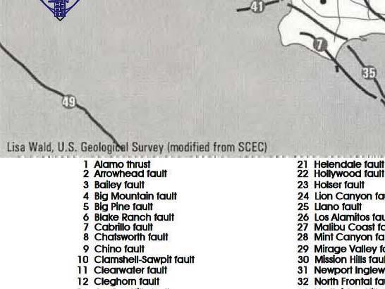
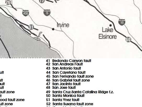
9 Figure IV.E-1 Regional Fault Map Page IV.E-9 Source: Geotechnologies, Inc., 2017; Eyestone Environmental, 2017;
10 Table IV.E-1 Seismic Source Summary Hillside Campus Fault Name Distance a (miles) Preferred Dip (degrees) and Direction Slip Sense Activity b Reference c Verdugo (Eagle Rock) NE Reverse PA 1,3 Sierra Madre N Reverse A 3 Raymond N Strike Slip A (EFZ) 2 Hollywood N Strike Slip A (EFZ) 2 Santa Monica Strike Slip PA 2 Elysian Park (Upper) NE Reverse 1 Sierra Madre (San Fernando) N Reverse A (EFZ) 2 Clamshell-Sawpit NW Reverse PA 3 San Gabriel N Strike Slip A (EFZ) 2 Puente Hills (LA) N Thrust 1 Elsinore (Whittier) NE Strike Slip A (EFZ) 2 Newport Inglewood Strike Slip A (EFZ) 2 Northridge S Thrust A 3 San Jose NW Strike Slip 1 Santa Susana N Reverse A 3 Malibu Coast N Strike Slip A (EFZ) 2 Anacapa Dume N Thrust PA 3 Palos Verdes V Strike Slip A 2 San Andreas V Strike Slip A (EFZ) 2 Cucamonga N Reverse A (EFZ) 2 Chino SW Strike Slip 2 Holser S Reverse 1 Simi-Santa Rosa Strike Slip A (EFZ) 2 Oak Ridge Reverse 1 San Joaquin Hills SW Thrust 1 San Jacinto V Strike Slip 1 San Cayetano N Thrust A (EFZ) 2 Cleghorn V Strike Slip 1 Newport Inglewood (Offshore) V Strike Slip A 3 Santa Ynez Strike Slip A 2 North Frontal S Reverse A (EFZ) 2 Garlock V Strike Slip A (EFZ) 2 Based on USGS 2014 National Seismic Hazard Maps. = Information is not available. a Based on the 2008 USGS California Fault-Distance Database (the latest available version). b A: Active; PA: Potentially Active; A (EFZ) = Active (Earthquake Fault Zone). c Reference 1: United States Geological Survey; Reference 2: California Geological Survey; Reference 3: County of Los Angeles, Department of Public Works, Source: Geotechnologies, Inc., Page IV.E-10
11 Table IV.E-2 Seismic Source Summary South Campus Fault Name Distance a (miles) Preferred Dip (degrees) and Direction Slip Sense Activity b Reference c Verdugo (Eagle Rock) NE Reverse PA 1,3 Raymond N Strike Slip A (EFZ) 2 Elysian Park (Upper) NE Reverse 1 Hollywood N Strike Slip A (EFZ) 2 Sierra Madre N Reverse A 3 Santa Monica Strike Slip PA 2 Clamshell-Sawpit NW Reverse PA 3 Elsinore (Whittier) NE Strike Slip A (EFZ) 2 Puente Hills (LA) N Thrust 1 Sierra Madre (San Fernando) N Reverse A (EFZ) 2 Newport Inglewood Strike Slip A (EFZ) 2 San Gabriel N Strike Slip A (EFZ) 2 San Jose NW Strike Slip 1 Northridge S Thrust A 3 Malibu Coast N Strike Slip A (EFZ) 2 Chino SW Strike Slip 2 Cucamonga N Reverse A (EFZ) 2 Santa Susana N Reverse A 3 Anacapa Dume N Thrust PA 3 Palos Verdes V Strike Slip A 2 San Andreas V Strike Slip A (EFZ) 2 Holser S Reverse 1 San Joaquin Hills SW Thrust 1 Simi-Santa Rosa Strike Slip A (EFZ) 2 San Jacinto V Strike Slip 1 Oak Ridge Reverse 1 Newport Inglewood (Offshore) V Strike Slip A 3 San Cayetano N Thrust A (EFZ) 2 Cleghorn V Strike Slip 1 North Frontal S Reverse A (EFZ) 2 Santa Ynez Strike Slip A 2 Coronado Bank V Strike Slip A 2 Based on USGS 2014 National Seismic Hazard Maps. = Information is not available. a Based on the 2008 USGS California Fault-Distance Database (the latest available version). b A: Active; PA: Potentially Active; A (EFZ) = Active (Earthquake Fault Zone). c Reference 1: United States Geological Survey; Reference 2: California Geological Survey; Reference 3: County of Los Angeles, Department of Public Works, Source: Geotechnologies, Inc., Page IV.E-11


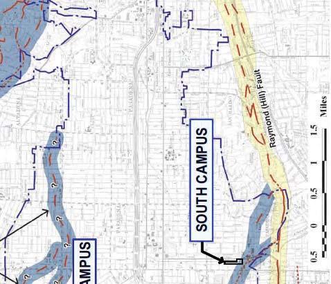
12 EXPLANATION Figure IV.E-2 Local Fault Map Source: Geotechnologies, Inc., 2017; Eyestone Environmental, 2017; Safety Element,Plate 1-2, Fault Map by Earth Consultants International, 2002.


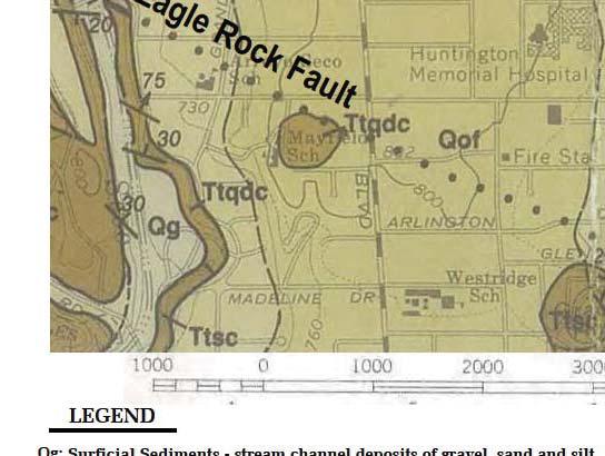

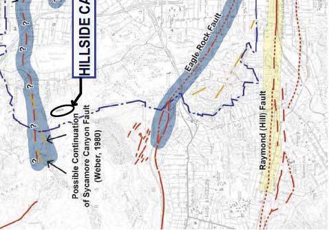
13 Figure IV.E-3 Local Geologic Map (South Campus) Page IV.E-13 Source: Geotechnologies, Inc., 2017; Eyestone Environmental, 2017; Dibblee, T.W., (1989) Geologic Map of the Pasadena Quadrangles (#DF-23).
14 from Monrovia to the Arroyo Seco in South Pasadena. The very bold, knife edge scarps in Monrovia parallel to Scenic Drive near the Hillside Campus is believed to be a fault scarp of the Raymond Fault. Trenches of the Raymond Fault have been identified as evidence of movement within the last 11,000 years (i.e., Holocene-age). The recurrence interval for the Raymond Fault is probably slightly less than 3,000 years, with the most recent documented event occurring approximately 1,600 years ago. However, historical accounts of an earthquake that reportedly occurred in July 1855 place the epicenter of a magnitude 6 earthquake within the Raymond Fault. It is believed that the Raymond Fault is capable of producing a 6.8 magnitude earthquake. The Raymond Fault is considered active by the CGS. Sierra Madre Fault System The closest trace of the Sierra Madre Fault is located approximately 2.75 miles to the north of the Hillside Campus and 5.15 miles to the north of the South Campus. The Sierra Madre Fault alone forms the southern tectonic boundary of the San Gabriel Mountains in the northern San Fernando Valley. It consists of a system of faults approximately 75 miles in length. The individual segments of the Sierra Madre Fault System extend up to 16 miles in length and dip to the north. The most recently active portions of the zone include the Mission Hills, Sylmar and Lakeview segments, which produced an earthquake of magnitude 6.4 in Tectonic rupture along the Lakeview Segment during the San Fernando Earthquake of 1971 produced displacements of approximately 2.5 to 4 feet upward and southwestward. It is believed that the Sierra Madre Fault System is capable of producing an earthquake of magnitude 7.3. Hollywood Fault The Hollywood Fault is located approximately 4.31 miles southwest of the Hillside Campus and 4.78 miles to the west of the South Campus. The Hollywood Fault is part of the Transverse Ranges Southern Boundary Fault System. This fault trends east-west along the base of the Santa Monica Mountains from the West Beverly Hills Lineament in the West Hollywood Beverly Hills area to the Los Feliz area of Los Angeles. The Hollywood Fault is the eastern segment of the Santa Monica Hollywood Fault. Based on geological trenching and physical evidence, this fault is classified as active. Multiple recent fault rupture hazard investigations have shown that the Hollywood Fault is located south of the ridges and bedrock outcroppings along portions of Sunset Boulevard. While the Hollywood Fault has not produced any damaging earthquakes during the historical period and has had relatively minor micro-seismic activity, it is estimated that the Hollywood Fault is capable of producing a maximum 6.7 magnitude earthquake. In 2014, the CGS established an Earthquake Fault Zone for the Hollywood Fault. Page IV.E-14
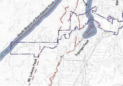
15 Whittier Elsinore Fault System The Whittier Fault is located approximately miles southeast of the Hillside Campus and miles to the southeast of the South Campus. The Whittier Fault together with the Chino Fault comprises the northernmost extension of the Elsinore Fault System. The mapped surface of the Whittier Fault extends in a west-northwest direction for a distance of 20 miles from the Santa Ana River to the end of the Puente Hills. The Whittier Fault is essentially a strike-slip, northeast dipping fault zone which also exhibits evidence of reverse movement along with en echelon 14 fault segments, en echelon folds, and braided fault segments. Right lateral offsets of stream drainages of up to 8,800 feet and vertical separation of the basement complex of 6,000 to 12,000 feet, have been documented. The Whittier Fault is capable of potentially producing a 7.8 magnitude earthquake. The Whittier Narrows earthquakes of October 1, 1987, and October 4, 1987, occurred in the area between the westernmost terminus of the mapped trace of the Whittier Fault and the frontal fault system. The main 5.9 magnitude shock of October 1, 1987, was not caused by slip on the Whittier Fault, and the quake ruptured a gently dipping thrust fault with an east-west strike. In contrast, the earthquake of October 4, 1987, is assumed to have occurred on the Whittier Fault as focal mechanisms show mostly strike-slip movement with a small reverse component on a steeply dipping northwest striking plane. San Gabriel Fault System The San Gabriel Fault System is located approximately miles north of the Hillside Campus and miles north of the South Campus. The San Gabriel Fault System comprises a series of subparallel, steeply north-dipping faults trending approximately north 40 degrees west with a right-lateral sense of displacement. There is also a small component of vertical dip-slip separation. The fault system exhibits a strong topographic expression and extends approximately 90 miles from San Antonio Canyon on the southeast to Frazier Mountain on the northwest. The estimated right lateral displacement on the fault varies from 34 miles to 40 miles, to 10 miles. Most scholars accept the larger displacement values and place the majority of activity between the Late Miocene and Late Pliocene Epochs of the Tertiary Era (65 to 1.8 million years before present). Portions of the San Gabriel Fault System are considered active by the CGS. Recent seismic exploration in the Valencia area has established Holocene offset. Radiocarbon 14 En echelon refers to closely-spaced, parallel or subparallel, overlapping or step-like minor structural features. Page IV.E-15
16 data indicate that faulting in the Valencia area occurred between 3,500 and 1,500 years before present. It is hypothesized that the Holocene offset on the San Gabriel Fault System is due to sympathetic (passive) movement as a result of north-south compression of the upper Santa Susana thrust sheet. Seismic evidence indicates that the San Gabriel Fault System is truncated at depth by the younger, north-dipping Santa Susana Sierra Madre Faults. Newport Inglewood Fault System The Newport Inglewood Fault System is located miles to the southwest of the Hillside Campus and miles to the southwest of the South Campus. The Newport Inglewood Fault System is a broad zone of discontinuous north to northwestern echelon faults and northwest to west trending folds. The fault zone extends southeastward from West Los Angeles, across the Los Angeles Basin, to Newport Beach and possibly offshore beyond San Diego. The onshore segment of the Newport Inglewood Fault System extends for about 37 miles from the Santa Ana River to the Santa Monica Mountains. There, it merges with the east-west trending Santa Monica zone of reverse faults. The surface expression of the Newport Inglewood Fault System is made up of a strikingly linear alignment of domal hills and mesas that rise on the order of 400 feet above the surrounding plains. From the northern end to its southernmost onshore expression, the Newport Inglewood Fault Zone is made up of: Cheviot Hills, Baldwin Hills, Rosecrans Hills, Dominguez Hills, Signal Hill Reservoir Hill, Alamitos Heights, Landing Hill, Bolsa Chica Mesa, Huntington Beach Mesa, and Newport Mesa. Several single and multiple fault strands, arranged in a roughly left stepping en echelon arrangement, make up the fault zone and account for the uplifted mesas. The most significant earthquake associated with the Newport Inglewood Fault System was the Long Beach earthquake of 1933 with a magnitude of 6.3 on the Richter scale. It is believed that the Newport Inglewood Fault System is capable of producing a 7.5 magnitude earthquake. Santa Susana Fault The closest trace of the Santa Susana Fault is located approximately 20.8 miles northwest of the Hillside Campus and miles to the northwest of the South Campus. The Santa Susana Fault extends approximately 17 miles west-northwest from the northwest edge of the San Fernando Valley into Ventura County and is at the surface high Page IV.E-16
17 on the south flank of the Santa Susana Mountains. The fault ends near the point where it overrides the south-side-up South strand of the Oak Ridge Fault. The Santa Susana Fault strikes northeast at the Fernando lateral ramp and turns east at the northern margin of the Sylmar Basin to become the Sierra Madre Fault. This fault is exposed near the base of the San Gabriel Mountains for approximately 46 miles from the San Fernando Pass at the Fernando lateral ramp east to its intersection with the San Antonio Canyon Fault in the eastern San Gabriel Mountains, east of which the range front is formed by the Cucamonga Fault. The Santa Susana Fault has not experienced any recent major ruptures except for a slight rupture during the 6.5 magnitude 1971 Sylmar earthquake. It is believed that the Santa Susana Fault has the potential to produce a 6.9 magnitude earthquake. The Santa Susana Fault is considered to be active by the County of Los Angeles. Malibu Coast Fault The Malibu Coast Fault Zone is approximately 21.8 miles west of the Hillside Campus and miles to the west of the South Campus. As part of the Transverse Ranges Southern Boundary Fault System, the Malibu Coast Fault Zone runs in an eastwest orientation onshore subparallel to and along the shoreline for a linear distance of about 17 miles through the Malibu City limits but also extends offshore to the east and west for a total length of approximately 37.5 miles. The onshore Malibu Coast Fault Zone involves a broad, wide zone of faulting and shearing as much as 1 mile in width. While the Malibu Coast Fault Zone has not been officially designated as an active fault zone by the State of California, and no Special Studies Zones have been delineated along any part of the fault zone under the Alquist Priolo Act of 1972, evidence for movement in the last 11,000 years (i.e., Holocene-age) has been established in several locations along individual fault splays within the fault zone. Due to such evidence, several fault splays within the onshore portion of the fault zone are identified as active. Large historic earthquakes along the Malibu Coast Fault include the 5.2 magnitude earthquake in 1979 and the 5.0 magnitude earthquake in This fault is believed to be capable of producing a maximum 7.0 magnitude earthquake. Palos Verdes Fault Studies indicate that there are several active on-shore extensions of the strike-slip Palos Verdes Fault, which is located approximately miles southwest of the Hillside Campus and miles southwest of the South Campus. Geophysical data also indicate the off-shore extensions of the fault are active, offsetting Holocene-age deposits. No historic large magnitude earthquakes are associated with this fault. However, the fault is considered active by the CGS. It is estimated that the Palos Verdes Fault is capable of producing a maximum 7.7 magnitude earthquake. Page IV.E-17
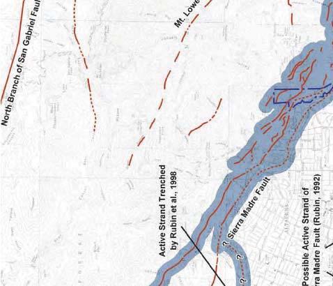
18 San Andreas Fault System The San Andreas Fault System forms a major plate tectonic boundary along the western portion of North America. The system is predominantly a series of northwest trending faults characterized by a predominant right lateral sense of movement. At its closest point, the San Andreas Fault System is located approximately miles to the northeast of the Hillside Campus and miles to the northeast of the South Campus. The San Andreas and associated faults have had a long history of inferred and historic earthquakes. Cumulative displacement along the system exceeds 150 miles in the past 25 million years. Large historic earthquakes have occurred at Fort Tejon in 1857, at Point Reyes in 1906, and at Loma Prieta in Based on single-event rupture length, the maximum Richter magnitude earthquake is expected to be approximately The recurrence interval for large earthquakes on the southern portion of the fault system is on the order of 100 to 200 years. (ii) Potentially Active Faults Verdugo Fault (Eagle Rock Fault/San Rafael Fault) Based on information obtained from the United States Geological Survey (USGS) database, the Verdugo Fault is the fault closest to both campuses, located approximately 1.32 miles to the southwest of the Hillside Campus and 0.42 mile to the southwest of the South Campus. The Verdugo Fault runs along the southwest edge of the Verdugo Mountains. The fault has been identified in the Burbank and Glendale areas with evidence of 2- to 3-meter-high scarps, which are steps or cliff-like features in ground surfaces resulting from the vertical movement along one side of a fault to the other. To the northeast in Sun Valley, a fault was reportedly identified at a depth of 40 feet in a sand and gravel pit. Although the Verdugo Fault is considered active by the County of Los Angeles Department of Public Works and the USGS, the CGS does not designate it as an Earthquake Fault Zone. It is estimated that the Verdugo Fault is capable of producing a maximum 6.9 magnitude earthquake. However, according to the Geotechnical Report, Regional Fault Map (Figure IV.E-1 on page IV.E-9), Local Fault Map (Figure IV.E-2 on page IV.E-12), and Local Geologic Map South Campus (Figure IV.E-3 on page IV.E-13), the fault closest to the Hillside Campus and South Campus is the Eagle Rock Fault, which is considered to be a segment of the Verdugo Fault System. According to the Technical Background Report of the 2002 Safety Element (Safety Element), the Eagle Rock Fault crosses the southwestern part of Pasadena. To the west, the Eagle Rock Fault lies on trend with the Verdugo Fault. To the Page IV.E-18
19 southeast, it appears to join the Raymond Fault at an exact location of the fault that is not well defined. However, according to Safety Element, at the time the Technical Background Report was prepared, very little was known about the Eagle Rock Fault, and no investigations were done in the Pasadena area. Nonetheless, the Technical Background Report concluded that because the Eagle Rock Fault was associated with the Raymond Fault (a known active fault) and the Verdugo Fault (a potentially active fault) that it should be considered potentially active and placed in a fault hazard management zone and subject to further study. 15 According to the Fault Rupture Study, due to the geometric association, proximity, and availability of research on the San Rafael Fault, that the Eagle Rock Fault near the South Campus can also be referred to as the San Rafael Fault. 16 Santa Monica Fault The Santa Monica Fault, located approximately 7.04 miles to the southwest of the Hillside Campus and 7.93 miles southwest of the South Campus, is also part of the Transverse Ranges Southern Boundary Fault System. The Santa Monica Fault extends east from the coastline in Pacific Palisades through Santa Monica and West Los Angeles and merges with the Hollywood Fault at the West Beverly Hills Lineament in Beverly Hills where its strike is northeast. It is believed that at least six surface ruptures have occurred in the past 50,000 years. In addition, a well-documented surface rupture occurred between 10,000 and 17,000 years ago, although a more recent earthquake potentially occurred 1,000 to 3,000 years ago. This leads to an average earthquake recurrence interval of 7,000 to 8,000 years. The Santa Monica Fault System is believed to have the capability of producing a 7.4 maximum magnitude earthquake. Anacapa Dume Fault The Anacapa Dume Fault, located approximately miles to the west of the Hillside Campus and miles to the west of the South Campus, is a near-vertical offshore escarpment exceeding 600 meters locally, with a total length exceeding 62 miles. This fault is also part of the Transverse Ranges Southern Boundary Fault System. It occurs as close as 3.6 miles offshore south of Malibu at its western end, but it trends northeast where it merges with the offshore segments of the Santa Monica Fault Zone. It is believed that the Anacapa Dume Fault is responsible for generating the historic 1930 magnitude 5.2 Santa Monica earthquake, the 1973 magnitude 5.3 Point Mugu earthquake, and the 1979 and 1989 Malibu earthquakes, each of which possessed a magnitude of 5.0. The Anacapa Dume Fault is thought to be capable of producing a maximum magnitude 7.2 earthquake , Technical Background Report to the 2002 Safety Element. Geotechnologies in their Review of Fault Rupture Study Report accepts this change in nomenclature. Page IV.E-19
20 (iii) Blind Thrust Faults Blind or buried thrust faults are faults without a surface expression but are a significant source of seismic activity. By definition, these faults have no surface trace, therefore the potential for ground surface rupture is considered remote. They are typically broadly defined based on the analysis of seismic wave recordings of hundreds of small and large earthquakes in the Southern California area. Due to the buried nature of these thrust faults, their existence is sometimes not known until they produce an earthquake. Two blind thrust faults in the Los Angeles metropolitan area are the Puente Hills Blind Thrust and the Elysian Park Blind Thrust. Another blind thrust fault of note is the Northridge Fault located in the northwestern portion of the San Fernando Valley. The Elysian Park Anticline is thought to overlie the Elysian Park Blind Thrust. This fault has been estimated to cause an earthquake every 500 to 1,300 years in the magnitude range 6.2 to 6.7. The Elysian Park Thrust Fault is located approximately 7.16 miles to the southwest of the Hillside Campus and 4.51 miles to the southwest of the South Campus. The Puente Hills Blind Thrust Fault extends eastward from Downtown Los Angeles to the City of Brea in northern Orange County. The Puente Hills Blind Thrust Fault includes three north-dipping segments, named from east to west as the Coyote Hills segment, the Santa Fe Springs segment, and the Los Angeles segment. These segments are overlain by folds expressed at the surface as the Coyote Hills, Santa Fe Springs Anticline, and the Montebello Hills. The closest segment of the Puente Hills Blind Thrust is located approximately 12.6 miles to the south of the Hillside Campus and miles to the south of the South Campus. The Santa Fe Springs segment of the Puente Hills Blind Thrust Fault is believed to be the cause of the Whittier Narrows Earthquake on October 1, Based on deformation of late Quaternary-age sediments above this fault system and the occurrence of the Whittier Narrows earthquake, the Puente Hills Blind Thrust Fault is considered an active fault capable of generating future earthquakes beneath the Los Angeles Basin. A maximum moment magnitude of 7.0 is estimated by researchers for the Puente Hills Blind Thrust Fault. The moment magnitude 6.7 Northridge earthquake was caused by the sudden rupture of a previously unknown, blind thrust fault. This fault has since been named the Northridge Thrust or, in some literature, the Pico Thrust. It has been assigned a maximum magnitude of 6.9 and a 1,500 to 1,800 year recurrence interval. The Northridge Thrust is located approximately miles to the northwest of the Hillside Campus and 18.2 miles to the northwest of the South Campus. Page IV.E-20
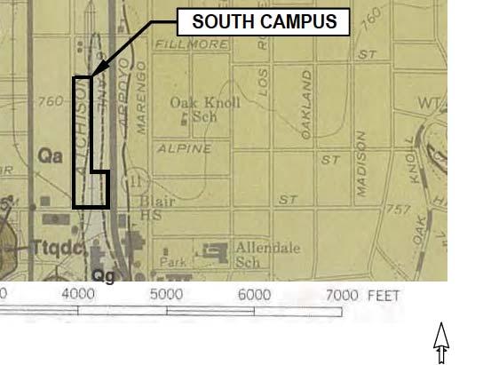
21 (b) Surface Ground Rupture Surface rupture is defined as surface displacement which occurs along the surface trace of the causative fault during an earthquake. Both the Hillside Campus and South Campus are not located within the limits of an Alquist Priolo Earthquake Fault Zone. The nearest Alquist Priolo Earthquake Fault Zone to the Hillside Campus and South Campus is the Raymond Fault. According to the USGS database, the Raymond Fault is located approximately 3.34 miles south of the Hillside Campus and 0.61 mile south of the South Campus with its fault zone located approximately 2,500 feet to the south. Based on research of available literature, no known active or potentially active faults, capable of surface rupture, underlie the Hillside Campus. According to the Geotechnical Report, several small faults were identified during previous explorations within the Hillside Campus, but none of these faults were determined to be active. As a result, it is concluded that the potential for surface ground rupture at the Hillside Campus is low. Local agencies can be more restrictive than the Alquist Priolo Earthquake Fault Zoning Act. While the CGS has not designated both the Verdugo Fault and Eagle Rock Fault as a designated Alquist Priolo Earthquake Fault Zone, the has delineated a Fault Hazard Management Zone for the Eagle Rock Fault, as seen in Figure IV.E-2 on page IV.E-12. The City considers the Eagle Rock Fault potentially active because it appears to be related to active faults in the area. Although the fault is not traced within the limits of the South Campus, the southwestern corner of the South Campus is located within this Fault Hazard Management Zone for the Eagle Rock Fault and is approximately 250 feet away from trace of the fault. As described above, since very little is known about the Eagle Rock Fault, the Safety Element suggests that geological studies to evaluate the potential for surface fault rupture of the Eagle Rock Fault should be undertaken. As a result, a fault rupture hazard study was conducted for the South Campus to determine the potential for surface ground rupture on the Project Site. According to the Fault Rupture Study, due to the geometric association, proximity, and availability of research on the San Rafael Fault, the Eagle Rock Fault near the South Campus was referred to as the San Rafael Fault. The Fault Rupture Study involved the following tasks: Site visit to observe the existing conditions at the South Campus and adjacent properties; Review of published historic topographic maps and aerial photographs for evidence of lineaments and other geomorphic indicators of fault traces; and Page IV.E-21
22 Review of published and unpublished available information on the Eagle Rock- San Rafael faults in the vicinity of the South Campus, Building Department building archives, and CGS s recent Fault Evaluation Reports, including the one prepared for the San Rafael Fault. Upon completion of the above tasks, the Fault Rupture Study concluded that recent studies show that the San Rafael Fault shows no evidence of fault rupture within the last 11,000 years (i.e., Holocene-age). These studies include the following: State Route 710 (SR-710) Final Geotechnical Report prepared by CH2M Hill evaluated the geologic conditions of several different routes in the region, including several routes and tunnels proposed in the vicinity of the South Campus. Numerous borings and geophysical methods were used to determine the subsurface conditions and to better locate fault trending through the area near the South Campus. This study determined that the San Rafael Fault separates the Topanga Group bedrock and from the diorite bedrock at depth but did not find evidence of faulting in the old alluvial fan deposits above the bedrock. Blair Middle School and Blair High School Geotechnical Investigations conducted by Geotechnical Professionals, Inc. involved cone penetration tests, hollow-stem auger borings, and geologic trench excavations to evaluate the geologic conditions at these two sites, which are immediately to the southeast of the South Campus on Glenarm Street east of Arroyo Parkway. The investigations determined that none of the previously mapped traces of the San Rafael Fault show evidence of rupturing within the Holocene period, and no future rupture evidence was encountered in the explorations. In addition, the geophysical survey conducted parallel to the South Campus indicated that faulted bedrock at depth is off-site and south of Glenarm Street. CGS recent Fault Evaluation Report for the San Rafael Fault did not find evidence to suggest that the fault is active, and, therefore, the fault does not meet the criteria to be zoned under the Alquist Priolo Earthquake Fault Zone Act. Therefore, the Fault Rupture Study determined that the San Rafael Fault does not appear to pass through or be located within 50 feet of the South Campus. Accordingly, no fault rupture hazard or the potential for surface ground rupture exists. Page IV.E-22
23 (3) Local Geology (a) Soil Conditions (i) Hillside Campus The Hillside Campus was mass graded in 1974 and 1975 by cutting several eastwest trending ridges and placing the material in the east-draining canyons. All of the fill soils were derived from on-site sources, with the fill consisting of clean sand and silty sand with varying quantities of clay and oversized rock up to 20 inches in dimension. Explorations identified the greatest thickness of fill on the order of 92 feet within the South Lot and 38 feet within the North Lot. The fill was found to be mottled reddish brown, brown or light brown, and dense. Meanwhile, pockets of relatively soft or easily excavated materials were also identified with moisture levels varying from slightly moist to wet. (ii) South Campus Fill materials were found to underlie the South Campus. Fill materials predominantly consist of silty sands and clays, which are dark gray to gray and yellowish-brown to brown in color, medium dense to medium stiff, fine grained, with minor gravel and brick fragments. The fill is, in turn, underlain by native alluvial soils, which consist predominantly of sediments deposited by river and stream action typical to this area of the Los Angeles County. The native alluvial soils consists of sands and silty sands with occasional layers of sandy silts, which are light brown to brown and gray in color, dense to very dense and stiff to hard, and fine to coarse grained. (b) Liquefaction Liquefaction is a phenomenon in which saturated silty to cohesionless soils below the groundwater table are subject to a temporary loss of strength due to the buildup of excess pore pressure during cyclic loading conditions such as those induced by an earthquake. Liquefaction-related effects include loss of bearing strength, amplified ground oscillations, lateral spreading, and flow failures. According to the Geotechnical Report, based on review of the Seismic Hazards Maps of the Pasadena Quadrangle included in Figure IV.E-4 on page IV.E-24, the Project Site s Hillside and South Campuses are not located within Liquefaction Hazard Zones. This determination is based on groundwater depth records, soil type, and distance to a fault capable of producing a substantial earthquake. Due to the very dense nature of the underlying soils and bedrock, and the depth to groundwater, the Hillside Campus and South Campus would not be considered susceptible Page IV.E-23


24 HILLSIDE CAMPUS Figure IV.E-4 Local Seismic Hazard Map (Hillside Campus) Page IV.E-24 Source: Geotechnologies, Inc., 2017; Eyestone Environmental, 2017; Seismic Hazard Zones, Pasadena Quadrangle Official Map (CDMG, 1999).
25 to liquefaction. Furthermore, the Hillside Campus and South Campus would not be considered susceptible to liquefaction effects, such as lateral spreading and surface manifestation. (c) Seismically Induced Settlement (i) Hillside Campus Some seismically induced settlement of the deep fill deposits, placed during mass grading within the Hillside Campus, should be expected as result of strong ground-shaking. No seismically induced settlement would occur in the dense granitic bedrock that underlies the Hillside Campus. It is anticipated that foundations to support new habitable structures proposed within the Hillside Campus will be deepened to bear in the underlying bedrock. Therefore, dynamic settlement among these structures may be considered negligible. At the Hillside Campus, granitic bedrock underlies variable thicknesses of certified and uncertified fill and colluvium. According to the Geotechnical Report, the existing fill and colluvium are not suitable for the support of new habitable structures, and foundations will have to bear in the underlying granitic bedrock. If the structures will bear in the granitic bedrock, the Hillside Campus site may be categorized as a Very Dense Soil and Soft Rock profile. (ii) South Campus Based on subsurface investigation, the native soils consist of dense alluvium categorized as a Stiff Soil profile. Minor seismically induced settlement of native alluvial soils could be expected at the South Campus as a result of strong ground-shaking. (d) Landslides (i) Hillside Campus According to the Geotechnical Report, based on review of the Seismic Hazards Map for the Hillside Campus included in Figure IV.E-4 on page IV.E-24, portions of the slope found to the east and west of the Hillside Campus are identified as an Earthquake-Induced Landslide Area. Based on the Landslide Inventory Map included in Figure IV.E-5 on page IV.E-26, there are no mapped landslides in the vicinity of the Hillside Campus. According to the Geotechnical Report, no major landslides have been mapped on the Hillside Campus or the vicinity because the granitic rocks that underlain the site are generally massive, with few through-going planar discontinuities in the rock. Page IV.E-25


26 Figure IV.E- Landslide Inventory Map Source: Geotechnologies, Inc., 2017; Eyestone Environmental, 2017; CDMG, Seismic Hazard Zone Report, 014, Pasadena 7.5-Minute Quadrangle, Los Angeles County, California (1998, Revised 2006).
27 (ii) South Campus As shown in Figure IV.E-6 on page IV.E-28, the probability of seismically induced landslides occurring on the South Campus is considered to be remote due to the general lack of substantive elevation difference across or adjacent to the site. (e) Collapsible Soils (i) Hillside Campus Hydroconsolidation is the collapse of soil resulting from soil sensitivity to an increase in moisture content. 17 Soils at the Hillside Campus are not considered prone to hydroconsolidation. (ii) South Campus The alluvial soils at the South Campus are not considered susceptible to significant hydroconsolidation. (f) Expansive Soils Expansive soils can experience volume changes as a result of changes in moisture content, and the upward pressures induced by swelling can affect structures and other surface improvements. 18 Based on the geotechnical investigations conducted on the Project Site s Hillside and South Campuses, it is anticipated that the on-site soils are in the very low to moderate expansion range. (g) Other Geologic Conditions The Hillside Campus and South Campus are not located within a zone of known subsidence due to oil or other fluid withdrawal. The campuses are not located within the limits of an oil field, and no oil or gas wells are reported to have been drilled on the campuses. In addition, sewer systems are available at both campuses for wastewater disposal. No septic tanks or alternative disposal systems exist at either campus County of Los Angeles, Department of Public Works, Building and Safety Division, Residential Code Manual, Policy on Foundations on Collapsible Soils, 2012., Safety Element of the General Plan, Page IV.E-27


 Source:")


28 SOUTH CAMPUS Figure IV.E-6 Local Seismic Hazard Map (South Campus) Source: Geotechnologies, Inc., 2017; Eyestone Environmental, 2017; Seismic Hazard Zones, Pasadena Quadrangle Official Map (CDMG, 1999).
IV. ENVIRONMENTAL IMPACT ANALYSIS E. GEOLOGY AND SOILS
 IV. ENVIRONMENTAL IMPACT ANALYSIS E. GEOLOGY AND SOILS INTRODUCTION This section evaluates potential impacts related to geology, including seismicity, and soils associated with development of the proposed
IV. ENVIRONMENTAL IMPACT ANALYSIS E. GEOLOGY AND SOILS
 IV. ENVIRONMENTAL IMPACT ANALYSIS E. GEOLOGY AND SOILS The following section is a summary of the geotechnical report conducted for the Proposed Project. The Geotechnical Engineering Investigation (the
APPENDIX IV.A Geotechnical Study
 City of Los Angeles February 2014 APPENDIX IV.A Geotechnical Study Technical Appendices Museum Square Office Building Draft Environmental Impact Report February 8, 2013 File No. 20477 5757 Wilshire, LLC
ENVIRONMENTAL IMPACT ANALYSIS C. GEOLOGY
 IV. ENVIRONMENTAL IMPACT ANALYSIS C. GEOLOGY This section summarizes the results of a geotechnical evaluation conducted for the proposed project by Jerry Kovacs and Associates, Inc. in August 1996. The
IV. ENVIRONMENTAL IMPACT ANALYSIS G. GEOLOGY AND SOILS
 IV. ENVIRONMENTAL IMPACT ANALYSIS G. GEOLOGY AND SOILS The following section is a summary of the geotechnical report conducted for the proposed project. The Report of Geotechnical Investigation Proposed
IV. ENVIRONMENTAL IMPACT ANALYSIS E. GEOLOGY/SOILS
 IV. ENVIRONMENTAL IMPACT ANALYSIS E. GEOLOGY/SOILS The following discussion is based upon information contained in the Hollywood Redevelopment Plan Amendment EIR and a letter prepared by Geotechnologies,
3.8 Geology/Soils. Environmental Setting. Topography. Geology and Soils
 3.8 Geology/Soils This section examines whether implementation of the 2004 Land Use Mobility Elements, Zoning Code Revisions, and Central District Specific Plan the will expose people or structures to
IV. Environmental Impact Analysis D. Geology
 IV. Environmental Impact Analysis D. Geology 1. Introduction This section evaluates potential geologic hazards and soil conditions associated with the proposed project, including fault rupture, ground
IV. ENVIRONMENTAL IMPACT ANALYSIS E. GEOLOGY/SOILS
 IV. ENVIRONMENTAL IMPACT ANALYSIS E. GEOLOGY/SOILS Except where otherwise noted, the following Section is based on the Preliminary Geotechnical Investigation, Proposed Medical Office Buildings and Mixed-Use
2.0 DATA COLLECTION AND LITERATURE REVIEW
 2.0 DATA COLLECTION AND LITERATURE REVIEW In order to perform the geotechnical evaluation, a comprehensive compilation and review of available publications, reports, and data was performed for all areas
GEOLOGY AND SOILS. This chapter summarizes geologic and geotechnical aspects of the site as they relate to the Project.
 9 GEOLOGY AND SOILS INTRODUCTION This chapter summarizes geologic and geotechnical aspects of the site as they relate to the Project. This chapter utilizes information from the following reports prepared
Appendix 6A Geologic Information about the Project Area prepared by Ninyo & Moore October 2008
 Appendix 6A Geologic Information about the Project Area prepared by Ninyo & Moore October 2008 Appendix 6A: Geologic Information about the Project Area 6A-1Existing Geologic and Subsurface Conditions
COMMUNITY DEVELOPMENT DEPARTMENT POLICY & PROCEDURE
 COMMUNITY DEVELOPMENT DEPARTMENT POLICY & PROCEDURE Policy No: DSP-OO3 Release Date: January 1, 2014 Effective Date: January 1, 2014 Revision Date: March 1, 2018 TITLE: The City Policy for Site Specific
4.5 GEOLOGY AND SEISMICITY
 4.5 GEOLOGY AND SEISMICITY INTRODUCTION This section identifies the potential for geologic and seismic hazards to occur on or near the proposed project site. Issues of concern include suitability of soil
IV. ENVIRONMENTAL IMPACT ANALYSIS E. GEOLOGY AND SOILS
 IV. ENVIRONMENTAL IMPACT ANALYSIS E. GEOLOGY AND SOILS The following analysis is based on the Geotechnical Investigation Report, Proposed Mid-Rise Multi- Family Residential Development Project Wetherly
Guidelines for Site-Specific Seismic Hazard Reports for Essential and Hazardous Facilities and Major and Special-Occupancy Structures in Oregon
 Guidelines for Site-Specific Seismic Hazard Reports for Essential and Hazardous Facilities and Major and Special-Occupancy Structures in Oregon By the Oregon Board of Geologist Examiners and the Oregon
IV. ENVIRONMENTAL IMPACT ANALYSIS K. GEOLOGIC AND SEISMIC HAZARDS
 IV. ENVIRONMENTAL IMPACT ANALYSIS K. GEOLOGIC AND SEISMIC HAZARDS 1. ENVIRONMENTAL SETTING This section provides an analysis of seismic hazards such as fault rupture, ground shaking, land sliding, and
IV. Environmental Impact Analysis F. Geology and Soils
 IV. Environmental Impact Analysis F. Geology and Soils 1. Introduction This section addresses potential geologic and soils hazards attributable to the Proposed Project. This section is based, in part,
GEOLOGY, SOILS, AND SEISMICITY
 4.9 GEOLOGY, SOILS, AND SEISMICITY 4.9.1 Introduction Information about the geological conditions and seismic hazards in the study area was summarized in the FEIR, and was based on the Geotechnical Exploration
3.10 GEOLOGY/SOILS/SEISMIC/TOPOGRAPHY
 3.10 GEOLOGY/SOILS/SEISMIC/TOPOGRAPHY The information in this section is based on the Geotechnical Final Report (January 2010) and Geotechnical Memorandum for the northern portion of the Study Area (Department
3E. Geology and Soils
 INTRODUCTION The purpose of this chapter is to evaluate the proposed project s impacts on local geological features and whether it would expose people or structures to adverse geological impacts. Potential
5. Environmental Analysis
 5.3 GEOLOGY AND SOILS The potential geology and soils impacts associated with development within The Platinum Triangle have been fully analyzed in two previous EIRs, including: Anaheim Stadium Area Master
3.4 GEOLOGY AND SOILS Environmental Setting
 3.4 GEOLOGY AND SOILS This section discusses the existing geologic and soils conditions and evaluates the potential impacts related to geology and soils as a result of the proposed project. This section
4.5 GEOLOGY AND SOILS
 4.5.1 Setting 4.5 GEOLOGY AND SOILS a. Regional Geology. The is located in the south central Santa Cruz Mountains in the heart of the Central Coast ranges of California. This is a seismically active region
4.5 GEOLOGY, SOILS AND SEISMICITY
 4.5 This section summarizes information on geology, soils and seismic hazards, and mineral resources in the Truckee area, as well as potential area-wide geologic hazards and regional seismic characteristics
IV. ENVIRONMENTAL IMPACT ANALYSIS G. GEOLOGY AND SOILS
 IV. ENVIRONMENTAL IMPACT ANALYSIS G. GEOLOGY AND SOILS INTRODUCTION The information and analysis in this section is based primarily on the following report, which is included in Appendix IV.G of this EIR:
C.Y. Geotech, Inc. Soil Engineering Investigation Victory Boulevard, Van Nuys, California. August 31, Ibid.
 E. SOILS AND GEOLOGY The purpose of this section is to assess impacts related to geologic resources resulting from construction and development of the proposed project and adjacent Add Area, such as seismically
9. GEOLOGY, SOILS, AND MINERALS
 June 28, 2018 Page 9-1 9. GEOLOGY, SOILS, AND MINERALS This EIR chapter describes the existing geological, soil, and mineral conditions in the planning area. The chapter includes the regulatory framework
IV. ENVIRONMENTAL IMPACT ANALYSIS C. GEOLOGY/SOILS
 IV. ENVIRONMENTAL IMPACT ANALYSIS C. GEOLOGY/SOILS The following section is a summary of the preliminary geotechnical consultation conducted for the Proposed Project. The Report of Geotechnical Engineering
Converse Consultants Geotechnical Engineering, Environmental & Groundwater Science, Inspection & Testing Services
 Converse Consultants Geotechnical Engineering, Environmental & Groundwater Science, Inspection & Testing Services Ms. Rebecca Mitchell Mt. San Antonio College Facilities Planning & Management 1100 North
COMMENT CARD RESPONSES (SEISMIC)
") COMMENT CARD 1 1. Please explain once and for all why the original route isn t an option while it s safer and cheaper, instead of going under the high school? Response: Please refer to the November Community
COMMENT CARD 1 1. Please explain once and for all why the original route isn t an option while it s safer and cheaper, instead of going under the high school? Response: Please refer to the November Community
1.0 INTRODUCTION 2.0 REGULATORY FRAMEWORK. 2.1 State and Regional Regulations Seismic Hazards Mapping Act
 IV.E GEOLOGY 1.0 INTRODUCTION This section of the Draft Environmental Impact Report (EIR) identifies and evaluates geologic and soils conditions at Loyola Marymount University (LMU) campus that could affect,
4.5 GEOLOGY AND SOILS
 4.5 GEOLOGY AND SOILS This section addresses the project site geology and soils and analyzes potential changes that would result from development of the Wye Specific Plan project. 4.5.1 Environmental Setting
3.3 GEOLOGY AND SOILS Environmental Setting Geologic Conditions
 3.3 GEOLOGY AND SOILS This section describes existing geologic and soil conditions, such as faults or unstable soils, and analyzes potential impacts that could pose hazards for the Fountain Valley Crossings
Appendix C - Geotechnical Report. Landmark Consultants, Inc.
 Appendix C - Geotechnical Report Landmark Consultants, Inc. LCI Report No. LP18128 Fault Map Regional Review of the current Alquist-Priolo Earthquake Fault Zone maps (CGS, 2000a) indicates that
Response to Leighton Consulting Report
 ` Contract No. PS-4350-2000 Response to Leighton Consulting Report Prepared for: Prepared by: 777 South Figueroa Street Suite 1100 Los Angeles, California 90017 May 14, 2012 1.0 Introduction 1.0 INTRODUCTION
ENGINEER S CERTIFICATION OF FAULT AREA DEMONSTRATION (40 CFR )
") PLATTE RIVER POWER AUTHORITY RAWHIDE ENERGY STATION BOTTOM ASH TRANSFER (BAT) IMPOUNDMENTS LARIMER COUNTY, CO ENGINEER S CERTIFICATION OF FAULT AREA DEMONSTRATION (40 CFR 257.62) FOR COAL COMBUSTION RESIDUALS
PLATTE RIVER POWER AUTHORITY RAWHIDE ENERGY STATION BOTTOM ASH TRANSFER (BAT) IMPOUNDMENTS LARIMER COUNTY, CO ENGINEER S CERTIFICATION OF FAULT AREA DEMONSTRATION (40 CFR 257.62) FOR COAL COMBUSTION RESIDUALS
COMMUNITY DEVELOPMENT DEPARTMENT POLICY & PROCEDURE
 COMMUNITY DEVELOPMENT DEPARTMENT POLICY & PROCEDURE Policy No: DSP-OO3 Release Date: January 1, 2014 Effective Date: January 1, 2014 Revision Date: March 1, 2018 TITLE: The City Policy for Site Specific
4.10 GEOLOGY, SOILS, AND SEISMICITY
 4.10 GEOLOGY, SOILS, AND SEISMICITY 4.10.1 INTRODUCTION This section describes the geology of the SVRTC and the susceptibility of site soils to seismically induced hazards. Faults in the corridor and past
2. Initial Summary of Preliminary Expert Opinion of Converse and Psomas Reports
 UNITED WALNUT TAXPAYERS PRELIMINARY REVIEW OF NEGATIVE GEOTECHNICAL AND GEOLOGICAL ASPECTS OF CONSTRUCTING EARTHFILL PAD FOR A SOLAR FARM ON THE WEST PARCEL - DRAFT 1. Introduction A licensed Engineering
3E. Geology and Soils
 The purpose of this section is to evaluate the proposed project s impacts on local geological features and whether it would expose people or structures to adverse geological impacts. Potential geologic
5.11 Geology and Soils
 5.11 Geology and Soils 5.11 GEOLOGY AND SOILS This section evaluates the geologic and seismic conditions within the City of Azusa and evaluates the potential for geologic hazard impacts associated with
3.1 GEOLOGY AND SOILS Introduction Definition of Resource
 3.1 GEOLOGY AND SOILS 3.1.1 Introduction 3.1.1.1 Definition of Resource The geologic resources of an area consist of all soil and bedrock materials. This includes sediments and rock outcroppings in the
Geo736: Seismicity and California s Active Faults Introduction
 Geo736: Seismicity and California s Active Faults Course Notes: S. G. Wesnousky Spring 2018 Introduction California sits on the boundary of the Pacific - North American plate boundary (Figure 1). Relative
Impact : Changes to Existing Topography (Less than Significant)
") 4.2 Land Resources 4.2.1 Alternative A Proposed Action Impact 4.2.1-1: Changes to Existing Topography (Less than Significant) Development of the project site would involve grading and other earthwork as
4.2 Land Resources 4.2.1 Alternative A Proposed Action Impact 4.2.1-1: Changes to Existing Topography (Less than Significant) Development of the project site would involve grading and other earthwork as
4. Geotechnical and Geological Aspects. 4.1 Geotechnical Aspects
 4. Geotechnical and Geological Aspects 4.1 Geotechnical Aspects A preliminary reconnaissance of the geotechnical conditions of Duzce, Kaynasli, and Bolu urban areas was done during the Turkey Expedition
IV. ENVIRONMENTAL IMPACT ANALYSIS G. GEOLOGY AND SOILS
 IV. ENVIRONMENTAL IMPACT ANALYSIS G. GEOLOGY AND SOILS The following section is based upon the City of El Segundo General Plan and General Plan EIR and addresses the following geologic issues: soil erosion,
5.3 GEOLOGY AND SOILS
 5.3 GEOLOGY AND SOILS SUMMARY The impact analysis presented in this section evaluates project impacts related to geologic hazards. The geotechnical analyses prepared for the project concluded that the
Implementation of the Alquist-Priolo Earthquake Fault Zoning Act in Los Angeles County
 Implementation of the Alquist-Priolo Earthquake Fault Zoning Act in Los Angeles County Charles Nestle County of Los Angeles Dept. of Public Works Surface Fault Rupture Workshop May 10, 2013 What Work is
F. GEOLOGY & SOILS. Organization of this Section. a) Regulatory Setting. i) State. ii) City of Los Angeles. iii) Anticipated Building Code Changes
 Regulatory Setting. i) State. ii) City of Los Angeles. iii) Anticipated Building Code Changes") IV. ENVIRONMENTAL IMPACT ANALYSIS F. GEOLOGY & SOILS This Section describes the geologic conditions at and near the Project Site and identifies the types of geotechnical hazards associated with development
IV. ENVIRONMENTAL IMPACT ANALYSIS F. GEOLOGY & SOILS This Section describes the geologic conditions at and near the Project Site and identifies the types of geotechnical hazards associated with development
IV. Environmental Impact Analysis D. Geology and Soils
 IV. Environmental Impact Analysis D. Geology and Soils 1. Introduction This section evaluates geologic and soils hazards that could potentially result due to implementation of the proposed project. Geologic
5. Environmental Analysis
 5.4 This section of the Draft Environmental Impact Report (DEIR) evaluates the potential for implementation of the San Gorgonio Pass Campus Master Plan to impact geological and soil resources. The analysis
Section 5.7 Geology and Soils
 Section 5.7 Section 5.7 5.7.1 PURPOSE This section describes the existing geologic, soil, and seismic conditions within the City of Artesia and identifies potential impacts that could result from implementation
SURFACE GEOLOGY AND LIQUEFACTION SUSCEPTIBILITY IN THE INNER RIO GRANDE VALLEY NEAR ALBUQUERQUE, NEW MEXICO
 SURFACE GEOLOGY AND LIQUEFACTION SUSCEPTIBILITY IN THE INNER RIO GRANDE VALLEY NEAR ALBUQUERQUE, NEW MEXICO Keith I. Kelson, Christopher S. Hitchcock, and Carolyn E. Randolph William Lettis & Associates,
4.4 GEOLOGY AND SOILS Existing Conditions
 4.4 GEOLOGY AND SOILS This section evaluates the direct, indirect, short-term, and long-term effects of the proposed Cypress College Facilities Master Plan (proposed project) on geology, soils, and exposure
Basin & Range / Mojave Desert
 Basin & Range / Mojave Desert Basin & Range vs. Great Basin 1 2/20/2016 An overview of the last horst Basin and Range / Mojave Desert Summary: Granitic, volcanic, marine sedimentary, non marine sedimentary,
Setting MOUNTAIN HOUSE NEIGHBORHOODS I AND J INITIAL STUDY 5. ENVIRONMENTAL CHECKLIST 6. GEOLOGY AND SOILS. Issue
 Issue Less Than Significant or No Impact Potential Significant Impact Adequately Addressed in MEIR MEIR Required Additional Review: No Significant Impact Less Than Significant Impact Due to Mitigation
Executive Summaries for the Century City Area Tunneling Safety Report and Fault Investigation Report
 ` Executive Summaries for the Century City Area Tunneling Safety Report and Fault Investigation Report Prepared for: Prepared by: October 19, 2011 Executive Summaries for the Century City Area Tunneling
November 16, 2016 Revised August 15, 2017 File No Trammell Crow Company 2221 Rosecrans Avenue, Suite 200 El Segundo, California 90245
 November 16, 2016 Revised August 15, 2017 File No. 21338-01 Trammell Crow Company 2221 Rosecrans Avenue, Suite 200 El Segundo, California 90245 Attention: Karen Shorr Subject: Geotechnical Assessment Site
The primary native soil types in the San Gabriel Mountains are silt loam and sand (SCAG, 2004).
.") 4.4 GEOLOGY AND SOILS 4.4.1 Existing Setting 4.4.1.1 Regional Geology and Soils The Master Plan study area is a 1-mile wide corridor along 58 river miles of the San Gabriel River in southern California,
4.4 GEOLOGY AND SOILS 4.4.1 Existing Setting 4.4.1.1 Regional Geology and Soils The Master Plan study area is a 1-mile wide corridor along 58 river miles of the San Gabriel River in southern California,
COMMUNITY DEVELOPMENT DEPARTMENT POLICY & PROCEDURE
 COMMUNITY DEVELOPMENT DEPARTMENT POLICY & PROCEDURE Policy No: DSP-OO3 Release Date: January 1, 2014 Effective Date: January 1, 2014 Revision Date: July 1, 2018 TITLE: The City Policy for Site-Specific
Lecture # 6. Geological Structures
 1 Lecture # 6 Geological Structures ( Folds, Faults and Joints) Instructor: Dr. Attaullah Shah Department of Civil Engineering Swedish College of Engineering and Technology-Wah Cantt. 2 The wavy undulations
IV. ENVIRONMENTAL IMPACT ANALYSIS A. GEOLOGY AND SOILS
 IV. ENVIRONMENTAL IMPACT ANALYSIS A. GEOLOGY AND SOILS A Geotechnical Evaluation for the proposed project was prepared by Zeiser King Consultants, Inc. in March 2003 to analyze the potential geology and
Sacramento Modesto Roseville Pleasanton September 19, 2013 Marcia Medina GHD Inc. 417 Montgomery Street, Suite 700 San Francisco, CA Subject: GE
 Sacramento Modesto Roseville Pleasanton September 19, 2013 Marcia Medina GHD Inc. 417 Montgomery Street, Suite 700 San Francisco, CA 94104 Subject: GEOTECHNICAL REPORT AMENDMENT Stonybrook Creek Crossings
LANDUSE APPLICATIONS OF EARTHQUAKE HAZARD MAPS CALIFORNIA EXPERIENCE
 LANDUSE APPLICATIONS OF EARTHQUAKE HAZARD MAPS CALIFORNIA EXPERIENCE Thomas C. Vlasic Vice President Spangle Associates Portola Valley, California INTRODUCTION The focus of this report is primarily on
Downtown Anchorage Seismic Risk Assessment & Land Use Regulations to Mitigate Seismic Risk
 Prepared for: The Municipality of Anchorage Planning Department and the Geotechnical Advisory Commission Downtown Anchorage Seismic Risk Assessment & Land Use Regulations to Mitigate Seismic Risk Prepared
5. Environmental Analysis
 5.11 This section of the Draft Environmental Impact Report (DEIR) evaluated potential impacts to mineral resources from implementation of the General Plan. 5.11.1 Environmental Setting Minerals are defined
5. Environmental Analysis
 5.4 This section of the DEIR evaluates the potential for implementation of the Puente Hills Intermodal Facility (PHIMF) project to impact geology and soils resources in the City of Industry and unincorporated
SONGS SSC. Tom Freeman GeoPentech PRELIMINARY RESULTS
 SONGS SSC Tom Freeman GeoPentech PRELIMINARY RESULTS Focused Questions Summarize the tectonic setting What is the seismogenic thickness? Are you including deep ruptures in the upper mantle (~30 km)? Do
CHAPTER 1 BASIC SEISMOLOGY AND EARTHQUAKE TERMINOLGY. Earth Formation Plate Tectonics Sources of Earthquakes...
 CHAPTER 1 BASIC SEISMOLOGY AND EARTHQUAKE TERMINOLGY Earth Formation... 1-2 Plate Tectonics... 1-2 Sources of Earthquakes... 1-3 Earth Faults... 1-4 Fault Creep... 1-5 California Faults... 1-6 Earthquake
Section 4.6 Geology and Soils Introduction
 4.6 invisible_toc_marker County of Kern Section 4.6 Geology and Soils 4.6.1 Introduction As described in Chapter 2 of this Supplemental EIR (SEIR), an EIR was previously certified for the Alta Oak Creek
NOA ASSESSMENT HARRIS QUARRY MENDOCINO COUNTY, CALIFORNIA TABLE OF CONTENTS
 NOA ASSESSMENT HARRIS QUARRY MENDOCINO COUNTY, CALIFORNIA TABLE OF CONTENTS Introduction... 1 Scope of Services... 1 Project Location and Description... 1 Geologic Setting... 1 Regional Geology... 1 Site
4.L GEOLOGY, SOILS, AND SEISMICITY 4.L.1 INTRODUCTION
 4.L GEOLOGY, SOILS, AND SEISMICITY 4.L.1 INTRODUCTION This section addresses potential environmental effects of the proposed TOD Plan for Downtown Inglewood and Fairview Heights related to geology, soils,
John Baldwin and Brian Gray Lettis Consultants International, Inc. Alexis Lavine AMEC Josh Goodman and Janet Sowers Fugro Consultants, Inc.
 John Baldwin and Brian Gray Lettis Consultants International, Inc. Alexis Lavine AMEC Josh Goodman and Janet Sowers Fugro Consultants, Inc. December 1, 2011 Pacific Gas & Electric SSHAC Workshop 1 San
Part 2 - Engineering Characterization of Earthquakes and Seismic Hazard. Earthquake Environment
 Part 2 - Engineering Characterization of Earthquakes and Seismic Hazard Ultimately what we want is a seismic intensity measure that will allow us to quantify effect of an earthquake on a structure. S a
4.4 GEOLOGY AND SOILS
 4.4 GEOLOGY AND SOILS This section analyzes potential geotechnical hazards that may adversely affect the project site or that may be exacerbated by implementation of the proposed project. Information presented
Slope Stability Evaluation Ground Anchor Construction Area White Point Landslide San Pedro District Los Angeles, California.
 Slope Stability Evaluation Ground Anchor Construction Area White Point Landslide San Pedro District Los Angeles, California Submitted To: Mr. Gene Edwards City of Los Angeles Department of Public Works
8.0 SUMMARY AND CONCLUSIONS
 8.0 SUMMARY AND CONCLUSIONS In November 2008, Pacific Gas and Electric (PG&E) informed the U.S. Nuclear Regulatory Commission (NRC) that preliminary results from the Diablo Canyon Power Plant (DCPP) Long
Geotechnical Engineering Engineering Geology
 Geotechnical Engineering Engineering Geology Geologic and Seismic Technical Background Report City of West Hollywood General Plan Update West Hollywood, Los Angeles County, California Prepared for: City
Geology, Soils, and Seismicity
 Section 3.8 Geology, Soils, and Seismicity Introduction This section generally evaluates the effects of the alternatives analyzed in this Supplemental DEIS with regard to geology, soils and seismicity.
V. ENVIRONMENTAL IMPACT ANALYSIS E. Geology and Soils E. GEOLOGY AND SOILS
 E. GEOLOGY AND SOILS The project site is located south and west of the Inglewood (Baldwin Hills) Oil Field, west of the intersection of Jefferson Boulevard and Overland Avenue between Freshman and Sophomore
4.5 GEOLOGY AND SOILS
 4.5 GEOLOGY AND SOILS Geologic and soil conditions on campus are generally as described in the 1989 LRDP EIR. Relevant information from the Earth Resources section (pages 147-157) in Volume I of that document
Converse Consultants Geotechnical Engineering, Environmental & Groundwater Science, Inspection & Testing Services
 Converse Consultants Geotechnical Engineering, Environmental & Groundwater Science, Inspection & Testing Services July 27, 2017 Ms. Rebecca Mitchell Mt. San Antonio College Facilities Planning & Management
5.4 GEOLOGY AND SOILS
 5.4 This section of the Draft Environmental Impact Report (DEIR) evaluates the potential for implementation of the Beach Boulevard Specific Plan (Proposed Project) to impact geological and soil resources
Roy Pyle March 24, 2017 Chief Facilities Planner Contra Costa Community College District 500 North Court Street Martinez, CA 94533
 State of California Natural Resources Agency Edmund G. Brown Jr., Governor Department of Conservation John G. Parrish, Ph.D., State Geologist California Geological Survey 801 K Street MS 12-31 Sacramento,
E-3: VAN BEVEREN & BUTELO, INC., TECHNICAL MEMORANDUM GEOTECHNICAL INPUT TO ENVIRONMENTAL DOCUMENTATION
 E-3: VAN BEVEREN & BUTELO, INC., TECHNICAL MEMORANDUM GEOTECHNICAL INPUT TO ENVIRONMENTAL DOCUMENTATION PROPOSED MIDDLE SCHOOL PROJECT, MAY 8, 2003 SCOPE This technical memorandum provides geotechnical
Field Trip Notes. It s L.A. s Fault. Active Faults of the northern Los Angeles Basin Field Excursion. Today s Staff & Educators
 School Programs Resources It s L.A. s Fault Field Trip Notes Active Faults of the northern Los Angeles Basin Field Excursion January 5, 2013 Today s Staff & Educators (From Yerkes et al., 1965) Lindsey
3.10 GEOLOGY AND SOILS
 3.10 GEOLOGY AND SOILS This section evaluates the potential impacts of the proposed project on geology, soils, and seismic hazards. This evaluation is based on the Preliminary Geotechnical Investigation
Overview of the Seismic Source Characterization for the Palo Verde Nuclear Generating Station
 Overview of the Seismic Source Characterization for the Palo Verde Nuclear Generating Station Scott Lindvall SSC TI Team Lead Palo Verde SSC SSHAC Level 3 Project Tuesday, March 19, 2013 1 Questions from
EVALUATION OF TSUNAMI RISK FOR COASTAL SOUTHERN CALIFORNIA CITIES. Appendix A - Figures
 EVALUATION OF TSUNAMI RISK FOR COASTAL SOUTHERN CALIFORNIA CITIES Appendix A - Figures Figure 1.Map showing major faults of the southern California region. Northwest-trending faults are rightslip in character.
Earth Mechanics, Inc. Geotechnical & Earthquake Engineering
 TECHNICAL MEMORANDUM EMI PROJECT NO: 13-116 DATE: October 29, 2013 PREPARED FOR: Mr. Todd W. Dudley / AECOM PREPARED BY: SUBJECT: (Raja) S. Pirathiviraj and Lino Cheang / (EMI) Preliminary Foundation Report
3.5.1 Environmental Setting
 This section describes geologic, seismic, and soil conditions in the proposed Project area and analyzes environmental impacts related to these issues that could result from the Project. The following discussion
The Seattle-area geologic mapping project and the geologic framework of Seattle
 The Seattle-area geologic mapping project and the geologic framework of Seattle Troost, K.G., D.B. Booth, S.A. Shimel, and M.A. O Neal, Univ. of Washington, Seattle 98195 Introduction The Puget Lowland
5.9 Geology and Soils
 5.9 Geology and Soils 5.9 GEOLOGY AND SOILS This section evaluates the geologic and seismic conditions within the City of Azusa and evaluates the potential for geologic hazard impacts associated with
4.4 GEOLOGY AND SOILS
 4.4 GEOLOGY AND SOILS SUMMARY This section describes the existing geologic and soils conditions on the project site, and the potential for geotechnical hazards to affect the Via Princessa East Extension
General Geologic Setting and Seismicity of the FHWA Project Site in the New Madrid Seismic Zone
 General Geologic Setting and Seismicity of the FHWA Project Site in the New Madrid Seismic Zone David Hoffman University of Missouri Rolla Natural Hazards Mitigation Institute Civil, Architectural & Environmental
Section 2 Geotechnical Fault Investigations Summary Memorandum Revision 1
 LOS ANGELES COUNTY METROPOLITAN TRANSPORTATION AUTHORITY, SECTION 2 ADVANCED PRELIMINARY ENGINEERING Contract No. PS-4350-2000 Section 2 Geotechnical Fault Investigations Summary Memorandum Revision 1
In the early morning hours of
 Figure 1. Brace that Chimney! Bracing of masonry chimneys is very difficult to do properly and has generally been ineffective in preventing their failure during earthquakes. While replacement of the chimney
4.7 GEOLOGY AND SEISMICITY
 4.7 GEOLOGY AND SEISMICITY This section describes the regional and local geology in the study area and the susceptibility of site soils to seismically induced hazards. The study area includes the entire
5. Environmental Analysis
 5.9 MINERAL RESOURCES 5.9.1 Methodology The California Geological Survey Mineral Resources Project provides information about California s nonfuel mineral resources. The primary focus of the Mineral Resources