5. Environmental Analysis
|
|
|
- Kristina Bates
- 5 years ago
- Views:
Transcription
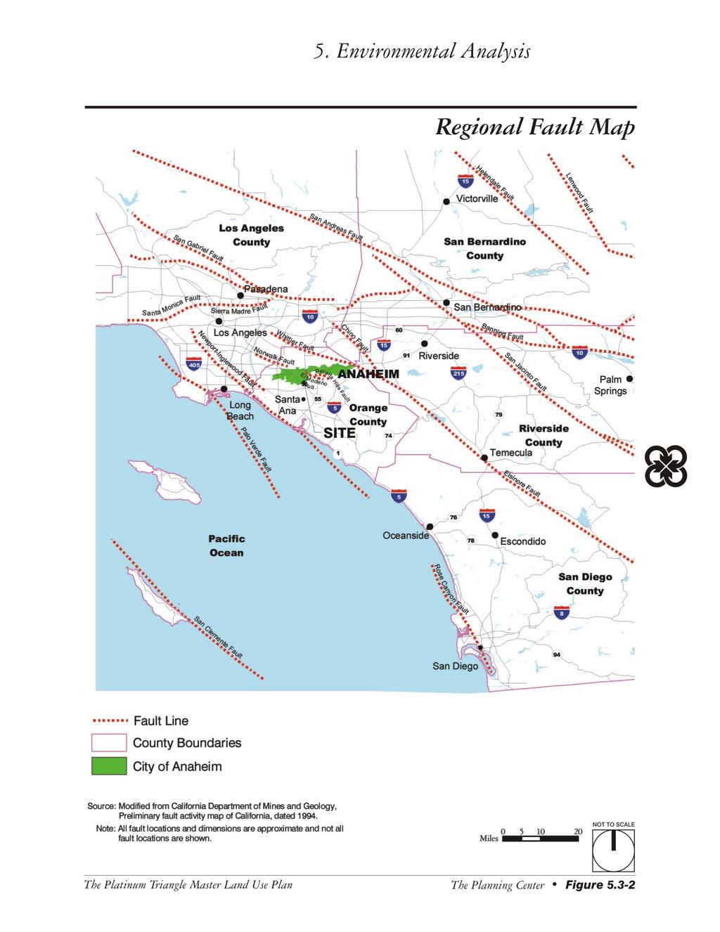
1 5.3 GEOLOGY AND SOILS The potential geology and soils impacts associated with development within The Platinum Triangle have been fully analyzed in two previous EIRs, including: Anaheim Stadium Area Master Land Use Plan FEIR No. 321, Michael Brandman Associates, January 1999 Anaheim General Plan and Zoning Code Update EIR No. 330, The Planning Center, May 25, 2004 The analysis contained in these EIRs is summarized below for the convenience of the reader and hereby incorporated by reference as set forth in full. A complete copy of both EIRs is available for review at the City of Anaheim Planning Department Environmental Setting Regional Geological Setting The Platinum Triangle (the Project Area) is located in the City of Anaheim in the northern portion of the Peninsular Ranges Geomorphic Province. This province encompasses an area that extends approximately 900 miles from the Transverse Ranges and the Los Angeles Basin, south to the southern tip of Baja California, Mexico. In general, the province consists of a northwest-southeast oriented complex of blocks separated by similarly trending faults. The Project Area is located within the southeastern portion of the Central Block of the Los Angeles Basin. The ground surface of the Central Block is represented by broad, low relief, essentially flat plain. The Central Block is a very elongated structural trough filled with many thousands of feet of quaternary and tertiary sediments. The Newport-Inglewood Fault trends northwestsoutheast approximately nine miles southwest of the Project Area, this fault zone represents the western edge of the Central Block and is characterized by several low, well-rounded hills along the fault trace. The northern portion of the Central Block is represented by the Whittier-Fault, approximately eight miles northeast of the Project Area at the base of the Puente Hills. Geologically, the Project Area is situated on a relatively flat surface with a shallow 16-foot-per-mile slope (250:1) to the southwest. This surface was formed by stream deposition meandering back and forth, creating a broad alluvial plain. The alluvial deposits were derived predominately from the Santa Ana River. A 2,000- foot thick section of alluvium (unconsolidated sediment) underlies the area. These materials consist of predominately horizontally bedded sand and silts. Based on borings in 1979, the alluvium has not been deformed or displaced significantly by folding or faulting to depths of at least 30 feet below the existing ground surface. The generalized geologic conditions within the Project Area are shown on Figure Local Faulting and Seismicity Earthquakes are common to Southern California. Geologic evidence is used to determine the likelihood of future rupture along a fault. Faults are described as active, potentially active, or inactive, based on their potential for activity. Those faults that give evidence of surface displacement within Holocene time (the last 11,000 years) have the highest potential of generating earthquakes again and are described as active. Distinct land forms suggesting fault movement within the last 11,000 years include sag ponds, off-site drainages, linear valleys, and springs. Special study zones, known as Alquist-Priolo Zones, have been established along active known faults in California in accordance with the Alquist-Priolo Earthquake Fault Zoning Act. No Alquist-Priolo Zones are located within The Platinum Triangle. The Platinum Triangle Subsequent EIR City of Anaheim Page 5-43
2 This page intentionally left blank. Page 5-44 The Planning Center May 2005

3 Generalized Geologic Map See Detail at Right NOT TO SCALE The Platinum Triangle Boundary The Platinum Triangle Master Land Use Plan The Planning Center Figure 5.3-1
4 This page intentionally left blank. Page 5-46 The Planning Center May 2005
5 The nearest active faults to the Project Area are the Newport-Inglewood Fault located approximately nine miles southwest of the Project Area and the Whittier Fault, located approximately eight miles northeast of the Project Area. The nearest potentially active fault is the El Modeno fault, which is located approximately five miles west of the Project Area. Earthquakes from several active and potentially active faults in the region could affect future developments within the Project Area. The active and potentially active faults which are capable of generating strong ground motion within the Project Area include the Newport-Inglewood, Whittier, and Elsinore faults. Other faults that may be capable of generating strong ground motion within the Project Area include faults located offshore (i.e., Palos Verdes Fault Zone), and local faults (i.e., Norwalk Fault Zone). The nearest faults to the Project Area are depicted in Figure Historic earthquakes that have caused substantial ground shaking in the Project Area include the 1857 Fort Tejon earthquake (magnitude 7.9) on the San Andreas Fault, the 1933 Long Beach earthquake (magnitude 6.3) along the Newport Inglewood Fault Zone, the 1987 Whittier Narrow earthquake (magnitude 5.9) on the Elysian Thrust Fault, and the 1992 Yucca Valley earthquake (magnitude 7.4). In addition, the 1994 Northridge earthquake (magnitude 6.6) caused substantial ground shaking in the Project Area and resulted in damage to Angel Stadium of Anaheim. As shown on Figure 5.3-3, the eastern edge of the Project Area generally located between the SR-57 Freeway and the Santa Ana River is situated within a zone of potential liquefaction as identified on Seismic Hazard Map (Anaheim Quadrangle) prepared by the State of California Division of Mines and Geology (DMG). Liquefaction occurs when loose, cohesionless, water-saturated soils (generally fine-grained sands) are subjected to strong seismic ground motion of significant duration. Liquefied soils may behave like liquids losing load bearing strength; however, they generally maintain some residual strength during and immediately after liquefaction. Structures located on liquefiable soils such as silt or sand may experience significant damage during an earthquake due to the instability of structural foundations and the moving earth. Liquefaction more often occurs in earthquake-prone areas underlain by young alluvium where the groundwater table is less than 50 feet below the ground surface. The magnitude and nature of settlement due to liquefaction depends on many factors including the homogeneity of the liquefiable layers, the depth to the liquefiable layer, the magnitude of the triggering event, and the duration of the shaking Thresholds of Significance According to Appendix G of the CEQA Guidelines, a project would normally have a significant effect on the environment if the project would: G-1 Expose people or structures to potential substantial adverse effects, including the risk of loss, injury, or death involving: Strong seismic ground shaking. Seismic-related ground failure, including liquefaction. G-2 Result in substantial soil erosion or the loss of topsoil. G-3 Be located on a geologic unit or soil that is unstable, or that would become unstable as a result of the project and potentially result in on-site or off-site landslide, lateral spreading, subsidence, liquefaction or collapse. G-4 Be located on expansive soil, as defined in Table 18-1B of the Uniform building Code (1994), creating substantial risks to life or property. The Platinum Triangle Subsequent EIR City of Anaheim Page 5-47
6 This page intentionally left blank. Page 5-48 The Planning Center May 2005
7
8 This page intentionally left blank. Page 5-50 The Planning Center May 2005

9 Seismic and Geologic Hazards See Detail at Right The Platinum Triangle Boundary NOT TO SCALE The Platinum Triangle Master Land Use Plan The Planning Center Figure 5.3-3
10 This page intentionally left blank. Page 5-52 The Planning Center May 2005
11 The Initial Study, included as Appendix A, substantiates that impacts associated with the following thresholds would be less than significant: G-1 Expose people or structures to potential substantial adverse effects, including the risk of loss, injury, or death involving: Rupture of a known earthquake fault, as delineated on the most recent Alquist-Priolo Earthquake Fault Zoning Map issued by the State Geologist for the area or based on other substantial evidence of a known fault (refer to Division of Mines and Geology Special Publication 42). Landslides. G-5 Have soils incapable of adequately supporting the use of septic tanks or alternative waste water disposal systems where sewers are not available for the disposal of waste water Environmental Impacts The following impact analysis addresses thresholds of significance for which the Initial Study disclosed potentially significant impacts. The applicable thresholds are identified in parentheses after the impact statement. IMPACT 5.3-1: EXISTING AND FUTURE STRUCTURES WITHIN THE PLATINUM TRIANGLE WOULD BE SUBJECTED TO POTENTIAL SEISMIC-RELATED HAZARDS. (THRESHOLDS G -1, G-2, AND G-3) Impact Analysis: As with other developments in Southern California, development associated with the project, may be exposed to impacts from earthquakes, including strong seismic ground shaking. The State regulates development in California through a variety of tools that reduce or mitigate potential hazards from earthquakes or other geologic hazards. The California Building Code (CBC), Unreinforced Masonry Law, Alquist-Priolo Earthquake Fault Zoning Act and the State of California Seismic Hazards Mapping Act govern development in potentially seismically active areas. The CBC contains provisions to safeguard against major structural failures or loss of life caused by earthquakes or other geologic hazards. According to the CBC, the Project Area is located in Seismic Zone 4, one of five zones (0 4) mapped in the CBC to identify areas subject to varying degrees of potential impact and frequency of large earthquakes. Seismic Zone 4 is potentially subject to the highest accelerations, or changes in speed or velocity due to seismic shaking, and has the greatest frequency of large earthquakes. The maximum peak ground acceleration in the Project Area would be 0.4g, which may result from a maximum credible magnitude earthquake of 7.5 on the Richter scale along the Whittier-Elsinore Fault. This maximum peak ground acceleration is similar to the acceleration that could be experienced throughout much of Southern California and is not unusually severe compared to general conditions in Southern California. However, the Proposed Project has the potential to expose future residents to the effects of geological hazards, including ground shaking, and seismic ground failure including liquefaction. Soil liquefaction is a seismically induced form of ground failure, which has been a major cause of earthquake damage in Southern California. During the 1971 San Fernando and 1994 Northridge earthquakes, significant damage to roads, utility pipelines, buildings and other structures was caused by liquefaction. Research and historical data indicate that loose, granular materials situated at depths of less than 50 feet with silt and clay contents of less than 30 percent that are saturated by a relatively shallow groundwater table are most The Platinum Triangle Subsequent EIR City of Anaheim Page 5-53
12 susceptible to liquefaction. These geological and groundwater conditions exist in parts of Southern California and Anaheim, typically in valley regions and alluviated floodplains. As shown on previous Figure 5.3-3, liquefaction has the potential to impact areas of the project generally located between the SR-57 Freeway and the Santa Ana River. Mapped liquefaction zones are intended to prompt more detailed, site specific, geotechnical studies as required by the California Seismic Hazard Mapping Act. In addition, the City s building codes require structures in these areas to be designed to withstand the potential impacts that could be caused by liquefaction. Property damage, personal injury, and loss of life may result from a major earthquake in the Project Area. Regional active faults are typical of Southern California; therefore, it is reasonable to expect a moderately strong ground motion seismic event to occur in the City of Anaheim in the future. However, compliance with the City of Anaheim s General Plan Goals and Policies, existing codes and regulations, and mitigation measures, will ensure that potential impacts will be less than significant. IMPACT 5.3-2: UNSTABLE GEOLOGIC UNIT OR SOILS CONDITIONS, INCLUDING SOIL EROSION, COULD RESULT DUE TO DEVELOPMENT OF THE PROJECT. (THRESHOLDS G-2 AND G-3) Impact Analysis: Erosion is a normal and inevitable geologic process whereby earth materials are loosened, worn away, decomposed or dissolved, and are removed from one place and transported to another location. Precipitation, running water, waves, and wind are all agents of erosion. Ordinarily, erosion proceeds so slowly as to be imperceptible, but when the natural equilibrium of the environment is changed, the rate of erosion can be greatly accelerated. This can create aesthetic as well as engineering problems. Accelerated erosion within an urban area can cause damage by undermining structures, blocking storm sewers and depositing silt, sand or mud in roads and tunnels. Eroded materials are eventually deposited into our coastal waters where the carried silt remains suspended for some time, constituting a pollutant and altering the normal balance of plant and animal life. The near-surface soils are generally medium-dense, fine, and fine-to-medium sand with occasional traces of gravel and infrequent seams of silt. The soils in the Project Area are considered to have a slight erosion potential. Development of the project will be located on relatively flat terrain that has no major geological constraints. While there is no possibility of landslide, the eastern side of the Project Area adjacent to the Santa Ana River has been identified as a zone of potential liquefaction and was previously discussed in the impact analysis for Impact More detailed, site-specific geotechnical studies as required by the California Seismic Hazard Mapping Act and the City s building codes will need to be performed as part of the development so that structures in these areas are designed to withstand the potential impacts that could be cased by liquefaction, subsidence, and collapse. Design and construction conducted in conformance with the Anaheim Municipal Code, the Uniform Building Code, and the recommendations contained in these sitespecific geotechnical studies should reduce any potential impacts related to liquefaction, lateral spreading, subsidence, and/or collapse to less than significant. The majority of the Project Area enjoys a relatively flat topography and minimal potential for erosion impacts. Development would be subject to local and State codes and requirements for erosion control and grading. In addition, project sites encompassing an area of one or more acres would require compliance with a National Pollutant Discharge Elimination System (NPDES) permit and consequently the development and implementation of a Storm Water Pollution Prevention Plan (SWPPP). With adherence to these codes and regulations and implementation of the General Plan Goals and Policies, impacts would be reduced to below a level of significance. Page 5-54 The Planning Center May 2005
13 IMPACT 5.3-3: SOIL CONDITIONS COULD RESULT IN RISKS TO LIFE OR PROPERTY. (THRESHOLD G-4) Impact Analysis: Expansive soils are those possessing clay particles that react to moisture changes by shrinking (when they dry) or swelling (when they become wet). Expansive soils can also consist of silty to sandy clay. The extent of shrinking and swelling is influenced by the environment, such as alternating wet and dry cycles, and by the amount of clay in the soil. This physical change in the soils can react unfavorably with building foundations, concrete walkways, swimming pools, roadways, masonry walls, etc. The nearsurface soils within The Platinum Triangle are generally medium-dense, fine and fine-to-medium sand with occasional traces of gravel and infrequent seams of silt. As a result, the expansion potential for these soils is considered low. Anaheim implements a number of existing codes and policies that serve to mitigate the impacts of development within areas containing expansive soils. Current codes and regulations relating to geology and soils are identified in the Anaheim Municipal Code, Title 17 Land Development and Resources. These codes address grading, excavation, fills, and watercourses, as well as applicable geotechnical report preparation and submittal. Application of the existing regulations identified in the Municipal Code and Uniform Building Code and grading regulations would minimize the risk associated with any development proposed within areas containing expansive soils Cumulative Impacts Impacts relating to soils and geologic influences are site specific and generally cannot be considered in cumulative terms. Mitigation of geologic, seismic, and soil impacts of development projects would be specific to each site. Modern building standards serve to reduce seismic related risks to less than significant levels. Therefore, no adverse cumulative impacts related to soils and geology are anticipated as a result of the Proposed Project Existing Regulations and Standard Conditions All grading operations shall be conducted in conformance with the Anaheim Municipal Code, Title 17 Land Development and Resources, and the most recent version of the Uniform Building Code for Seismic Zone 4. Under the Statewide General Construction NPDES Permit (Order DWQ), the project proponent shall submit a Notice of Intent (NOI) to the State Water Resources Control Board prior to the commencement of construction activities. In addition, a SWPPP shall be prepared and implemented at the project site, and revised as necessary as administrative or physical conditions change. The SWPPP shall describe Best Management Practices (BMPs) that address pollutant source reduction and provide measures/controls necessary to mitigate potential pollutant sources. The general categories of BMPs include erosion controls, sediment controls, tracking controls, wind erosion control, non-storm water management, and materials and waste management (i.e., good housekeeping practices) Level of Significance Before Mitigation Upon implementation of existing regulatory requirements and standard conditions of approval, Impacts and would be less than significant. However, without mitigation, Impact is considered potentially significant. The Platinum Triangle Subsequent EIR City of Anaheim Page 5-55
14 5.3.7 Mitigation Measures Applicable Measures from MMP No. 106 The following mitigation measures were included in Updated and Modified Mitigation Monitoring Program No. 106 for The Platinum Triangle, and were previously adopted as part of the Stadium Area Master Land Use Plan EIR and the General Plan and Zoning Code Update EIR No Additions are shown in bold and deletions are indicated in strikeout format Prior to approval of a grading plan, if within a Seismic Hazard Zone, the property owner/ developer shall submit to the Public Works Department a site specific report in compliance with DMG Special Publication 117, Guidelines for Evaluating and Mitigating Seismic Hazards in California. The report shall be prepared by an engineering geologist and geotechnical engineer. All grading shall be in conformance with Title 17 of the City of Anaheim Municipal Code Prior to issuance of a building permit, the property owner/developer shall submit to the Planning Department, Building Division, for review and approval, detailed foundation design information for the proposed buildings, prepared by a civil engineer, based on recommendations of a geotechnical engineer Prior to issuance of a building permit, the property owner/developer shall submit to the Planning Department, Building Division, a report prepared by a geotechnical engineer for review and approval which shall investigate the subject foundation excavations Prior to issuance of a building permit, the property owner/developer shall submit to the Planning Department, Building Division, plans showing that the proposed structure(s) has been analyzed for earthquake loading and designed according to the most recent seismic standards in the Uniform Building Code adopted by the City of Anaheim Prior to final building inspection, for any proposed hotel uses, the property owner/developer shall submit an earthquake emergency response plan to the City of Anaheim Planning Department, Building Division, for review and approval. The plan shall require posted notices in all hotel rooms and earthquake safety procedures and incorporate on-going earthquake training for hotel staff On-going during grading operations, the property owner/developer shall implement standard practices from City Ordinance (Title 17) and policies to the satisfaction of the Public Works Department, Field Engineering Division. Additional Mitigation No additional mitigation measures are required Level of Significance After Mitigation The mitigation measures identified above would reduce potential impacts associated with geology and soils to a level that is less than significant. Therefore, no significant unavoidable adverse impacts relating to geology and soils have been identified. Page 5-56 The Planning Center May 2005
IV. ENVIRONMENTAL IMPACT ANALYSIS G. GEOLOGY AND SOILS
 IV. ENVIRONMENTAL IMPACT ANALYSIS G. GEOLOGY AND SOILS The following section is a summary of the geotechnical report conducted for the proposed project. The Report of Geotechnical Investigation Proposed
IV. ENVIRONMENTAL IMPACT ANALYSIS E. GEOLOGY AND SOILS
 IV. ENVIRONMENTAL IMPACT ANALYSIS E. GEOLOGY AND SOILS The following section is a summary of the geotechnical report conducted for the Proposed Project. The Geotechnical Engineering Investigation (the
GEOLOGY AND SOILS. This chapter summarizes geologic and geotechnical aspects of the site as they relate to the Project.
 9 GEOLOGY AND SOILS INTRODUCTION This chapter summarizes geologic and geotechnical aspects of the site as they relate to the Project. This chapter utilizes information from the following reports prepared
IV. ENVIRONMENTAL IMPACT ANALYSIS E. GEOLOGY AND SOILS
 IV. ENVIRONMENTAL IMPACT ANALYSIS E. GEOLOGY AND SOILS The following analysis is based on the Geotechnical Investigation Report, Proposed Mid-Rise Multi- Family Residential Development Project Wetherly
IV. ENVIRONMENTAL IMPACT ANALYSIS E. GEOLOGY AND SOILS
 IV. ENVIRONMENTAL IMPACT ANALYSIS E. GEOLOGY AND SOILS INTRODUCTION This section evaluates potential impacts related to geology, including seismicity, and soils associated with development of the proposed
IV. ENVIRONMENTAL IMPACT ANALYSIS E. GEOLOGY/SOILS
 IV. ENVIRONMENTAL IMPACT ANALYSIS E. GEOLOGY/SOILS The following discussion is based upon information contained in the Hollywood Redevelopment Plan Amendment EIR and a letter prepared by Geotechnologies,
IV. ENVIRONMENTAL IMPACT ANALYSIS E. GEOLOGY/SOILS
 IV. ENVIRONMENTAL IMPACT ANALYSIS E. GEOLOGY/SOILS Except where otherwise noted, the following Section is based on the Preliminary Geotechnical Investigation, Proposed Medical Office Buildings and Mixed-Use
Setting MOUNTAIN HOUSE NEIGHBORHOODS I AND J INITIAL STUDY 5. ENVIRONMENTAL CHECKLIST 6. GEOLOGY AND SOILS. Issue
 Issue Less Than Significant or No Impact Potential Significant Impact Adequately Addressed in MEIR MEIR Required Additional Review: No Significant Impact Less Than Significant Impact Due to Mitigation
9. GEOLOGY, SOILS, AND MINERALS
 June 28, 2018 Page 9-1 9. GEOLOGY, SOILS, AND MINERALS This EIR chapter describes the existing geological, soil, and mineral conditions in the planning area. The chapter includes the regulatory framework
IV. ENVIRONMENTAL IMPACT ANALYSIS G. GEOLOGY AND SOILS
 IV. ENVIRONMENTAL IMPACT ANALYSIS G. GEOLOGY AND SOILS INTRODUCTION The information and analysis in this section is based primarily on the following report, which is included in Appendix IV.G of this EIR:
3.8 Geology/Soils. Environmental Setting. Topography. Geology and Soils
 3.8 Geology/Soils This section examines whether implementation of the 2004 Land Use Mobility Elements, Zoning Code Revisions, and Central District Specific Plan the will expose people or structures to
4.L GEOLOGY, SOILS, AND SEISMICITY 4.L.1 INTRODUCTION
 4.L GEOLOGY, SOILS, AND SEISMICITY 4.L.1 INTRODUCTION This section addresses potential environmental effects of the proposed TOD Plan for Downtown Inglewood and Fairview Heights related to geology, soils,
Impact : Changes to Existing Topography (Less than Significant)
") 4.2 Land Resources 4.2.1 Alternative A Proposed Action Impact 4.2.1-1: Changes to Existing Topography (Less than Significant) Development of the project site would involve grading and other earthwork as
4.2 Land Resources 4.2.1 Alternative A Proposed Action Impact 4.2.1-1: Changes to Existing Topography (Less than Significant) Development of the project site would involve grading and other earthwork as
4.5 GEOLOGY AND SOILS
 4.5.1 Setting 4.5 GEOLOGY AND SOILS a. Regional Geology. The is located in the south central Santa Cruz Mountains in the heart of the Central Coast ranges of California. This is a seismically active region
3.3 GEOLOGY AND SOILS Environmental Setting Geologic Conditions
 3.3 GEOLOGY AND SOILS This section describes existing geologic and soil conditions, such as faults or unstable soils, and analyzes potential impacts that could pose hazards for the Fountain Valley Crossings
3E. Geology and Soils
 INTRODUCTION The purpose of this chapter is to evaluate the proposed project s impacts on local geological features and whether it would expose people or structures to adverse geological impacts. Potential
4.5 GEOLOGY AND SOILS
 4.5 GEOLOGY AND SOILS This section addresses the project site geology and soils and analyzes potential changes that would result from development of the Wye Specific Plan project. 4.5.1 Environmental Setting
5.11 Geology and Soils
 5.11 Geology and Soils 5.11 GEOLOGY AND SOILS This section evaluates the geologic and seismic conditions within the City of Azusa and evaluates the potential for geologic hazard impacts associated with
4.9 GEOLOGY AND SOILS
 4.9 GEOLOGY AND SOILS 4.9.1 EXISTING CONDITIONS TOPOGRAPHY AND RELIEF Zone 40 is located in the central portion of Sacramento County. The topography of the county is represented by three physiographic
4.5 GEOLOGY, SOILS AND SEISMICITY
 4.5 This section summarizes information on geology, soils and seismic hazards, and mineral resources in the Truckee area, as well as potential area-wide geologic hazards and regional seismic characteristics
3.4 GEOLOGY AND SOILS Environmental Setting
 3.4 GEOLOGY AND SOILS This section discusses the existing geologic and soils conditions and evaluates the potential impacts related to geology and soils as a result of the proposed project. This section
GEOLOGY, SOILS, AND SEISMICITY
 4.9 GEOLOGY, SOILS, AND SEISMICITY 4.9.1 Introduction Information about the geological conditions and seismic hazards in the study area was summarized in the FEIR, and was based on the Geotechnical Exploration
IV. ENVIRONMENTAL IMPACT ANALYSIS C. GEOLOGY/SOILS
 IV. ENVIRONMENTAL IMPACT ANALYSIS C. GEOLOGY/SOILS The following section is a summary of the preliminary geotechnical consultation conducted for the Proposed Project. The Report of Geotechnical Engineering
IV. ENVIRONMENTAL IMPACT ANALYSIS G. GEOLOGY AND SOILS
 IV. ENVIRONMENTAL IMPACT ANALYSIS G. GEOLOGY AND SOILS The following section is based upon the City of El Segundo General Plan and General Plan EIR and addresses the following geologic issues: soil erosion,
4.5 GEOLOGY AND SEISMICITY
 4.5 GEOLOGY AND SEISMICITY INTRODUCTION This section identifies the potential for geologic and seismic hazards to occur on or near the proposed project site. Issues of concern include suitability of soil
5. Environmental Analysis
 5.4 This section of the Draft Environmental Impact Report (DEIR) evaluates the potential for implementation of the San Gorgonio Pass Campus Master Plan to impact geological and soil resources. The analysis
IV. Environmental Impact Analysis D. Geology
 IV. Environmental Impact Analysis D. Geology 1. Introduction This section evaluates potential geologic hazards and soil conditions associated with the proposed project, including fault rupture, ground
Section 4.6 Geology and Soils Introduction
 4.6 invisible_toc_marker County of Kern Section 4.6 Geology and Soils 4.6.1 Introduction As described in Chapter 2 of this Supplemental EIR (SEIR), an EIR was previously certified for the Alta Oak Creek
4.5 Geology and Soils
 Environmental Impact Analysis Geology and Soils 4.5 Geology and Soils This section assesses potential impacts related to geologic and soil hazards. 4.5.1 Setting a. Topography and Geology San Leandro is
4.6 GEOLOGY AND SOILS
 The analysis in this Subsection is based, in part, on information contained in four (4) reports prepared by Southern California Geotechnical that assessed the existing surface and subsurface geologic conditions.
3.4 Geology/Soils/Paleontological Resources
 Section 3.4 Geology, Soils, and Paleontological Resources This section evaluates potential geology and soils impacts, and also paleontological impacts. The analysis is based on a preliminary geotechnical
4.6 GEOLOGY AND SOILS
 LSA ASSOCIATES, INC. MARCH 2008 FINAL ENVIRONMENTAL IMPACT REPORT YUCCA VALLEY RETAIL SPECIFIC PLAN The purpose of the Geology and Soils section is to evaluate whether the proposed project would create
4.6 GEOLOGY AND SOILS
 4.6 GEOLOGY AND SOILS The purpose of the Geology and Soils section is to evaluate whether the proposed project would expose people or structures to major geotechnical hazards or substantially contribute
IV. Environmental Impact Analysis D. Geology and Soils
 IV. Environmental Impact Analysis D. Geology and Soils 1. Introduction This section evaluates geologic and soils hazards that could potentially result due to implementation of the proposed project. Geologic
5.3 GEOLOGY AND SOILS
 5.3 GEOLOGY AND SOILS SUMMARY The impact analysis presented in this section evaluates project impacts related to geologic hazards. The geotechnical analyses prepared for the project concluded that the
IV. ENVIRONMENTAL IMPACT ANALYSIS F. GEOLOGY AND SOILS
 IV. ENVIRONMENTAL IMPACT ANALYSIS F. GEOLOGY AND SOILS INTRODUCTION This section of the DEIR evaluates potential impacts to the project site s geologic environment that may result from implementation of
3.10 GEOLOGY/SOILS/SEISMIC/TOPOGRAPHY
 3.10 GEOLOGY/SOILS/SEISMIC/TOPOGRAPHY The information in this section is based on the Geotechnical Final Report (January 2010) and Geotechnical Memorandum for the northern portion of the Study Area (Department
Section 5.7 Geology and Soils
 Section 5.7 Section 5.7 5.7.1 PURPOSE This section describes the existing geologic, soil, and seismic conditions within the City of Artesia and identifies potential impacts that could result from implementation
4.4 GEOLOGY AND SOILS Existing Conditions
 4.4 GEOLOGY AND SOILS This section evaluates the direct, indirect, short-term, and long-term effects of the proposed Cypress College Facilities Master Plan (proposed project) on geology, soils, and exposure
5.9 Geology and Soils
 5.9 Geology and Soils 5.9 GEOLOGY AND SOILS This section evaluates the geologic and seismic conditions within the City of Azusa and evaluates the potential for geologic hazard impacts associated with
4.5 GEOLOGY AND SOILS
 4.5 GEOLOGY AND SOILS This section discusses the proposed project s potential impacts relating to geologic hazards. This section is partially based on the Preliminary Soil Engineering and Geologic Hazards
ENVIRONMENTAL IMPACT ANALYSIS C. GEOLOGY
 IV. ENVIRONMENTAL IMPACT ANALYSIS C. GEOLOGY This section summarizes the results of a geotechnical evaluation conducted for the proposed project by Jerry Kovacs and Associates, Inc. in August 1996. The
COMMUNITY DEVELOPMENT DEPARTMENT POLICY & PROCEDURE
 COMMUNITY DEVELOPMENT DEPARTMENT POLICY & PROCEDURE Policy No: DSP-OO3 Release Date: January 1, 2014 Effective Date: January 1, 2014 Revision Date: March 1, 2018 TITLE: The City Policy for Site Specific
3.1.3 Geology and Soils
 3.1.3 Geology and Soils This section addresses the potential geology and soils impacts associated with implementation of The Villages Escondido Country Club Project (Project). The section describes the
4.6 GEOLOGY AND SOILS
 4.6 GEOLOGY AND OIL 4.6.1 ummary able 4.6-1 summarizes the identified environmental impacts, proposed mitigation measures, and residual impacts of the proposed project with regard to geology and soils.
4.6 GEOLOGY, SOILS, AND MINERAL RESOURCES
 Ascent Environmental 4.6 GEOLOGY, SOILS, AND MINERAL RESOURCES This section of the EIR describes the existing geology, soils, and mineral resources at and in the vicinity of the project site and analyzes
C.Y. Geotech, Inc. Soil Engineering Investigation Victory Boulevard, Van Nuys, California. August 31, Ibid.
 E. SOILS AND GEOLOGY The purpose of this section is to assess impacts related to geologic resources resulting from construction and development of the proposed project and adjacent Add Area, such as seismically
3.10 GEOLOGY AND SOILS
 3.10 GEOLOGY AND SOILS This section evaluates the potential impacts of the proposed project on geology, soils, and seismic hazards. This evaluation is based on the Preliminary Geotechnical Investigation
Geology, Soils, and Seismicity
 Section 3.8 Geology, Soils, and Seismicity Introduction This section generally evaluates the effects of the alternatives analyzed in this Supplemental DEIS with regard to geology, soils and seismicity.
4.5 GEOLOGY AND SOILS
 4.5 GEOLOGY AND SOILS Geologic and soil conditions on campus are generally as described in the 1989 LRDP EIR. Relevant information from the Earth Resources section (pages 147-157) in Volume I of that document
4.5 GEOLOGY AND SOILS
 4.5.1 INTRODUCTION This resource section evaluates the potential environmental effects related to geology and soils from implementation of. The analysis includes a review of regional geology, seismicity
Appendix 6A Geologic Information about the Project Area prepared by Ninyo & Moore October 2008
 Appendix 6A Geologic Information about the Project Area prepared by Ninyo & Moore October 2008 Appendix 6A: Geologic Information about the Project Area 6A-1Existing Geologic and Subsurface Conditions
SLOPE STABILITY EVALUATION AND ACCEPTANCE STANDARDS
 INFORMATION BULLETIN / PUBLIC - BUILDING CODE REFERENCE NO.: LAMC 98.0508 Effective: 1-26-84 DOCUMENT NO. P/BC 2002-049 Revised: 11-1-02 Previously Issued As: RGA #1-84 SLOPE STABILITY EVALUATION AND ACCEPTANCE
4.2.5 Geology and Soils
 4.2.5 Geology and Soils Introduction This section evaluates potential geologic, seismic, and soils (geological) impacts associated with construction and operation of the proposed (WVLCSP) project. Specifically,
SLOPE STABILITY EVALUATION AND ACCEPTANCE STANDARDS
 INFORMATION BULLETIN / PUBLIC - BUILDING CODE REFERENCE NO.: LABC 7006.3, 7014.1 Effective: 01-01-2017 DOCUMENT NO.: P/BC 2017-049 Revised: 12-21-2016 Previously Issued As: P/BC 2014-049 SLOPE STABILITY
3.5 GEOLOGY Introduction Environmental Setting
 3.5 GEOLOGY 3. Affected Environment and Environmental Analysis 3.5 GEOLOGY 3.5.1 Introduction This section provides information about the geologic conditions of the project site and surrounding area, and
5.5 Geology, Soils and Seismicity
 5.5 Geology, Soils and Seismicity 5.5.1 Introduction Information and recommendations presented in this section were taken from the original East Lake Specific Plan Environmental Impact Report (EIR) [State
Section 3.5 Geology and Soils ENVIRONMENTAL SETTING GEOLOGIC SETTING
 Section 3.5 Geology and Soils This section discusses the environmental setting, existing conditions, regulatory context, and potential impacts of the project in relation to geology and soils. The information
3.5 GEOLOGY Introduction Environmental Setting
 3.5 GEOLOGY 3. Affected Environment and Environmental Analysis 3.5 GEOLOGY 3.5.1 Introduction This section provides information about the geologic conditions of the project site and surrounding area, and
5.5 GEOLOGY, SOILS, AND SEISMICITY
 5.5 GEOLOGY, SOILS, AND SEISMICITY This section of the environmental impact report (EIR) describes the existing geology and soils conditions in the Project area and analyzes the potential for impacts associated
IV. ENVIRONMENTAL IMPACT ANALYSIS E. GEOLOGY AND SOILS
 IV. ENVIRONMENTAL IMPACT ANALYSIS E. GEOLOGY AND SOILS INTRODUCTION This section of the (Draft EIR) evaluates potential geology and soils impacts associated with development of the proposed (proposed Project
3.6 GEOLOGY AND SOILS
 3.6 GEOLOGY AND SOILS This section of the EIR examines the regional and local geologic and soil characteristics of the project site and surrounding area. For the lagoon enhancement component, the analysis
IV. ENVIRONMENTAL IMPACT ANALYSIS K. GEOLOGIC AND SEISMIC HAZARDS
 IV. ENVIRONMENTAL IMPACT ANALYSIS K. GEOLOGIC AND SEISMIC HAZARDS 1. ENVIRONMENTAL SETTING This section provides an analysis of seismic hazards such as fault rupture, ground shaking, land sliding, and
5.6 GEOLOGY, SOILS, AND SEISMICITY
 This section discusses the geology of the Project area and general vicinity and analyzes hazards related to geology and soils, such as potential exposure of people and property to geologic hazards, landform
5.5 Geology and Soils
 5.5 Geology and Soils The analysis in this section of the EIR addresses the potential impacts associated with geology and soils that may occur due to implementation of the proposed Collier Park Renovations
4.5 Geology, Soils and Seismicity Environmental Setting Impacts and Mitigation Measures References...4.
 TABLE OF CONTENTS 4.5 Geology, Soils and Seismicity...4.5-1 4.5.1 Environmental Setting...4.5-1 4.5.2 Impacts and Mitigation Measures...4.5-6 4.5.3 References...4.5-9 FIGURES Figure 4.5-1 Active and Potentially
3.5 Geology, Soils, and Paleontology
 3.5 Geology, Soils, and Paleontology Overview of Impacts The analytical approach taken by this Subsequent EIR is described in Section 3.0 (Introduction to Environmental Analysis). The following section
3.5 Geology and Soils
 3.5 GEOLOGY AND SOILS The following reports have been prepared to analyze the geological impacts of the proposed project and are included in their entirety in Appendices F1 through F7 of this Draft Environmental
Section 4.6 Geology and Soils
 Section 4.6 Geology and Soils 4.6.1 Introduction Section 4.6 Geology and Soils This section describes effects on geology and soils that would be caused by implementation of the proposed and Jawbone Wind
4.6 GEOLOGY AND SOILS
 4.6 GEOLOGY AND SOILS This section provides an overview of geological and seismic conditions in the CPAs and evaluates geology and soils impacts associated with the Proposed Plans. This section was prepared
5.5 GEOLOGY/SOILS EXISTING CONDITIONS. Regulatory Setting
 5.5 GEOLOGY/SOILS This section describes existing environmental conditions related to geology and soils in the project area, including W-19, the disposal site, and beach placement sites proposed as part
5. Environmental Analysis
 5.4 This section of the DEIR evaluates the potential for implementation of the Puente Hills Intermodal Facility (PHIMF) project to impact geology and soils resources in the City of Industry and unincorporated
3.0 SUMMARY OF POTENTIAL GEOTECHNICAL IMPACTS AND MITIGATION MEASURES
 3.0 SUMMARY OF POTENTIAL GEOTECHNICAL IMPACTS AND MITIGATION MEASURES This section summarizes the principal geotechnical conditions that occur in the project area. The potential impact that each condition
4.5 Geology and Soils
 4.5 Geology and Soils This section evaluates potential geology and soils impacts that could affect or result from the future development consistent with the Encinitas Housing Element Update (HEU). Information
4.4 GEOLOGY AND SOILS
 4.4 GEOLOGY AND SOILS SUMMARY This section describes the existing geologic and soils conditions on the project site, and the potential for geotechnical hazards to affect the Via Princessa East Extension
No comments related to geology and soils were received during public review of the Notice of Preparation.
 Ascent Environmental 4.5 Geology and Soils GEOLOGY AND SOILS 4.5.1 Introduction This section identifies and evaluates potential impacts that could result from geologic or soil conditions as a result of
5. Environmental Analysis
 5.11 This section of the Draft Environmental Impact Report (DEIR) evaluated potential impacts to mineral resources from implementation of the General Plan. 5.11.1 Environmental Setting Minerals are defined
5.4 GEOLOGY AND SOILS
 5.4 This section of the Draft Environmental Impact Report (DEIR) evaluates the potential for implementation of the Beach Boulevard Specific Plan (Proposed Project) to impact geological and soil resources
5. Environmental Analysis
 5.9 MINERAL RESOURCES 5.9.1 Methodology The California Geological Survey Mineral Resources Project provides information about California s nonfuel mineral resources. The primary focus of the Mineral Resources
4.5 GEOLOGY AND SOILS
 4.5 GEOLOGY AND SOILS This section discusses the Project s potential impacts relating to geologic hazards. This section is partially based on the Geotechnical Engineering Report included in Appendix E.
Guidelines for Site-Specific Seismic Hazard Reports for Essential and Hazardous Facilities and Major and Special-Occupancy Structures in Oregon
 Guidelines for Site-Specific Seismic Hazard Reports for Essential and Hazardous Facilities and Major and Special-Occupancy Structures in Oregon By the Oregon Board of Geologist Examiners and the Oregon
4.4 GEOLOGY AND SOILS
 4.4 GEOLOGY AND SOILS This section analyzes potential geotechnical hazards that may adversely affect the project site or that may be exacerbated by implementation of the proposed project. Information presented
4.7 GEOLOGY AND SOILS
 4.7 GEOLOGY AND SOILS 4.7.1 INTRODUCTION This section describes geology, soils, and seismicity conditions in the vicinity of the project sites and assesses the potential for the project to be affected
3.6 Geology, Soils, and Seismicity
 0 0... Existing Conditions... Regulatory Setting Federal There are no federal laws, regulations, or standards related to geology and soils that are applicable to the Proposed Project. State Alquist-Priolo
2.10 Geology/Soils/Seismic/Topography
 2.10 Geology/Soils/Seismic/Topography 2.10.1 Regulatory Setting This section discusses geology, soils, and seismic concerns as they relate to public safety and project design. Earthquakes are prime considerations
3.18 GEOLOGY AND SOILS
 3.18 GEOLOGY AND SOILS This section discusses geologic resource concerns as they relate to the environment, public safety, and project design both during construction and after completion of the project.
3.7 GEOLOGY, SOILS, MINERALS, AND PALEONTOLOGICAL RESOURCES
 3.7 GEOLOGY, SOILS, MINERALS, AND PALEONTOLOGICAL RESOURCES This section contains an analysis of impacts related to geology, soils, mineral resources, and paleontological resources. The analysis describes
The primary native soil types in the San Gabriel Mountains are silt loam and sand (SCAG, 2004).
.") 4.4 GEOLOGY AND SOILS 4.4.1 Existing Setting 4.4.1.1 Regional Geology and Soils The Master Plan study area is a 1-mile wide corridor along 58 river miles of the San Gabriel River in southern California,
4.4 GEOLOGY AND SOILS 4.4.1 Existing Setting 4.4.1.1 Regional Geology and Soils The Master Plan study area is a 1-mile wide corridor along 58 river miles of the San Gabriel River in southern California,
IV. ENVIRONMENTAL IMPACT ANALYSIS E. GEOLOGY/SEISMIC HAZARDS
 IV. ENVIRONMENTAL IMPACT ANALYSIS E. GEOLOGY/SEISMIC HAZARDS 1. ENVIRONMENTAL SETTING The following analysis of geology and seismic hazards for the Middle School Project is based on the Report of Geotechnical
ENGINEER S CERTIFICATION OF FAULT AREA DEMONSTRATION (40 CFR )
") PLATTE RIVER POWER AUTHORITY RAWHIDE ENERGY STATION BOTTOM ASH TRANSFER (BAT) IMPOUNDMENTS LARIMER COUNTY, CO ENGINEER S CERTIFICATION OF FAULT AREA DEMONSTRATION (40 CFR 257.62) FOR COAL COMBUSTION RESIDUALS
PLATTE RIVER POWER AUTHORITY RAWHIDE ENERGY STATION BOTTOM ASH TRANSFER (BAT) IMPOUNDMENTS LARIMER COUNTY, CO ENGINEER S CERTIFICATION OF FAULT AREA DEMONSTRATION (40 CFR 257.62) FOR COAL COMBUSTION RESIDUALS
8.0 GEOLOGY AND SOILS
 This section describes the current geologic and soil conditions at each of the Dollar General project sites and analyzes issues related to geology and soils. Geotechnical studies have been prepared for
5. Environmental Analysis
 5.9 MINERAL RESOURCES This section of the EIR evaluates the potential for implementation of the City of San Bernardino General Plan Update, and the Arrowhead Springs Specific Plan to impact mineral resources
IV. Environmental Impact Analysis F. Geology and Soils
 IV. Environmental Impact Analysis F. Geology and Soils 1. Introduction This section addresses potential geologic and soils hazards attributable to the Proposed Project. This section is based, in part,
4.6 GEOLOGIC AND SEISMIC SMIC HAZARDS
 4.6 GEOLOGIC AND SEISMIC SMIC HAZARDS This section describes the current conditions relating to the geologic and seismic characteristics within the City of Carson. This section concludes with an assessment
CHAPTER GEOLOGICALLY HAZARDOUS AREAS Applicability Regulations.
 CHAPTER 19.07 GEOLOGICALLY HAZARDOUS AREAS 19.07.010 Applicability. Geologically hazardous areas may pose a threat to the health and safety of citizens when incompatible development is sited in areas of
GEOLOGY AND SOILS 7.1 INTRODUCTION 7.2 ENVIRONMENTAL SETTING Regulatory Context
 CHAPTER 7.0 GEOLOGY AND SOILS 7.1 INTRODUCTION This chapter describes the geologic and soils characteristics of Phases 1 and 2 of the proposed Plan area and evaluates the extent to which implementation
PHYSICAL SCIENCE FINAL
 PHYSICAL SCIENCE FINAL Liquefaction Doreen Wallace, Tesla Grogan, Amber Ward, Erik Garcia, Cinthia Salas, Alexis Albers Liquefaction What is it? Conditions needed How it works Effects of Liquefaction Soil
appendix e: geologic and seismic hazards
 appendix e: geologic and seismic hazards CONTENTS: E-2 Fault Rupture E-3 Ground Shaking E-5 Seismic Ground Deformation E-5 Liquification E-6 Seismically Induces Landslide E-6 Landslide Hazard E The following
5.4 GEOLOGY AND SOILS
 5.4 GEOLOGY AND SOILS INTRODUCTION This section describes the geology and soils of the project site and analyzes issues such as potential exposure of people and future improvements to geologic and seismic
Implementation of the Alquist-Priolo Earthquake Fault Zoning Act in Los Angeles County
 Implementation of the Alquist-Priolo Earthquake Fault Zoning Act in Los Angeles County Charles Nestle County of Los Angeles Dept. of Public Works Surface Fault Rupture Workshop May 10, 2013 What Work is