BEM Model of slip on the Channel Islands Thrust, CA
|
|
|
- John Arthur Jacobs
- 5 years ago
- Views:
Transcription


1 BEM Model of slip on the Channel Islands Thrust, CA


 www.mve.")

2 Credit Where Credit is Due: Michele Cooke Michele Cooke UMass Amherst Has been training students/postdocs to work with and remesh the CFM since at least 2003 Michele and I have developed slightly different tools/methods, but our overall approach and goals are the same Main meshing software Move suite (Midland Valley Exploration) Available to academic institutes for a small annual fee ~ 200/yr We also use several home-grown Perl scripts for various tasks First* publication using CFM-based mesh: Griffith & Cooke (2004)
3 Publications Using Various Remeshed CFM s 1. Griffith, W. A., and M. L. Cooke (2004), Mechanical validation of the threedimensional intersection geometry between the Puente Hills blind-thrust system and the Whittier fault, Los Angeles, California, Bulletin of the Seismological Society of America, 94(2), Griffith, W. A., and M. L. Cooke (2005), How sensitive are fault slip rates in the Los Angeles Basin to tectonic boundary conditions?, Bulletin of the Seismological Society of America, 95(4), Olson, E. L., and M. L. Cooke (2005), Application of three fault growth criteria to the Puente Hills thrust system, Los Angeles, California, USA, Journal of Structural Geology, 27, Cooke, M. L., and S. T. Marshall (2006), Fault slip rates from threedimensional models of the Los Angeles metropolitan area, California, Geophysical Research Letters, 33(L21313), Marshall, S. T., M. L. Cooke, and S. E. Owen (2008), Effects of non-planar fault topology and mechanical interaction on fault slip distributions in the Ventura Basin, California, Bulletin of the Seismological Society of America, 98(3), Meigs, A. J., M. L. Cooke, and S. T. Marshall (2008), Using vertical rock uplift patterns to infer and validate the three-dimensional fault configuration in the Los Angeles basin, Bulletin of the Seismological Society of America, 98(2), Dair, L., and M. L. Cooke (2009), San Andreas fault geometry through the San Gorgonio Pass, California, Geology, 37(2), Marshall, S. T., M. L. Cooke, and S. E. Owen (2009), Interseismic deformation associated with three-dimensional faults in the greater Los Angeles region, California, Journal of Geophysical Research, 114(B12403), Cooke, M. L., and L. C. Dair (2011), Simulating the recent evolution of the southern big bend of the San Andreas fault, southern California, Journal of Geophysical Research, 116(B-44-5). 10. Herbert, J. W., and M. L. Cooke (2012), Sensitivity of the southern San Andreas fault system to tectonic boundary conditions and fault configurations, Bulletin of the Seismological Society of America, 102(5), Madden, E. H., and D. D. Pollard (2012), Integration of surface slip and aftershocks to constrain the 3D structure of faults involved in the M7.3 Landers earthquake, southern California, Bulletin of the Seismological Society of America, 102(1), Marshall, S. T., G. J. Funning, and S. E. Owen (2013), Fault slip rates and interseismic deformation in the western Transverse Ranges, CA, Journal of Geophysical Research, 118, Fattaruso, L. A., M. L. Cooke, and R. J. Dorsey (2014), Sensitivity of uplift patterns to dip of the San Andreas fault in the Coachella Valley, California, Geosphere, 10(6), Herbert, J. W., M. L. Cooke, and S. T. Marshall (2014a), Influence of fault connectivity on slip rates in southern California: Potential impact on discrepancies between geodetic derived and geologic slip rates, Journal of Geophysical Research: Solid Earth, 119(3), Herbert, J. W., M. L. Cooke, M. Oskin, and O. Difo (2014b), How much can off-fault deformation contribute to the slip rate discrepancy within the eastern California shear zone?, Geology, 42(1), Fattaruso, L. A., M. L. Cooke, R. J. Dorsey, and B. A. Housen (2016), Response of deformation patterns to reorganization of the southern San Andreas fault system since ca. 1.5 Ma, Tectonophysics, 693, Part B, Marshall, S. T., G. J. Funning, H. E. Krueger, S. E. Owen, and J. P. Loveless (2017), Mechanical models favor a ramp geometry for the Ventura-pitas point fault, California, Geophysical Research Letters, 44(3), **Apologies if I left yours out!


4 The Raw CFM: The Good The Raw CFM Mesh Is highly irregular mesh density/resolution triangle shape/size The Northridge Thrust (CFM5.0) Many triangles have poor aspect ratios The Good The mesh is carefully constructed based on all available data TONS of work! Mesh density shows where there is data and where there is not Packaged as ascii files (tsurfs) Easy to read/write Relocated aftershocks from Carena & Suppe (2002)

 Some faults have small gaps/holes Difficult to visually detect Can write scripts do check")
5 The Raw CFM: Potential Issues Mesh Quality The mesh is has too much variation in triangle size/shape to be numerically stable Ideal: Equilateral triangles (not possible for nonplanar/irregular faults) The Santa Monica Bay Thrust (CFM5.0) Some faults have small gaps/holes Difficult to visually detect Can write scripts do check this I can share mine, if anyone is interested
6 Subsurface Fault Intersections The Raw CFM: Potential Issues The CFM mesh does not intersect faults along triangle edges BEM models calculate values at Elt centroids Interpenetrating Elts can cause stress singularities Kinematic models are OK with intersections Faults must be remeshed to intersect along triangle edges Subsurface intersections are typically unconstrained The Newport-Inglewood fault (blue) intersects the Compton Thrust (gray) in CFM5.0


7 The Raw CFM: Potential Issues CFM Surfaces only cover Seismogenic Depths Modeling interseismic deformation requires extending faults to depth Must extend faults beyond CFM depths Marshall et al. (2009, JGR) provides a computationally-efficient method Many faults many intersect when extended Unconstrained; requires arbitrary geometric decisions Should small faults be extended? How far? Gray: The Imperial Fault (CFM5) Blue: Remeshed & Extended

 Modeling Challenges Most BEM models use a halfspace Could make a surface topography mesh Shear traction-free Surface would be complex")
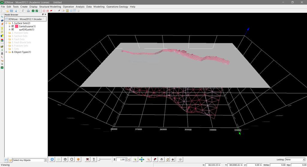
8 The Raw CFM: Potential Issues Fault Traces Follow Topography Z-values are elevation, not depth Fault traces go up to their actual surface elevation Most faults don t occur at high elevations Total surface area above z=0 is typically small Offshore faults don t go to z=0 (are they blind?) Modeling Challenges Most BEM models use a halfspace Could make a surface topography mesh Shear traction-free Surface would be complex (many elts) Would need to fix fault intersections with surface (very time consuming) Increase computation time The Santa Susana Fault (CFM5)
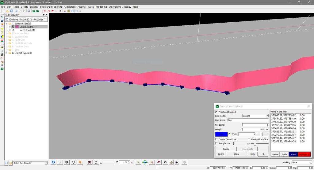
9 Flattening Topography: Two Choices Choice #1 Project the surface trace down to some datum (z=0) The Good Fault trace is in correct location The Bad Fault is at least one of the following: Mislocated in the subsurface Incorrect dip and mislocated Must curve/kink to merge with correct fault location at depth Surface area changes These cause significant changes in mechanics Z = 0 Actual Fault Trace


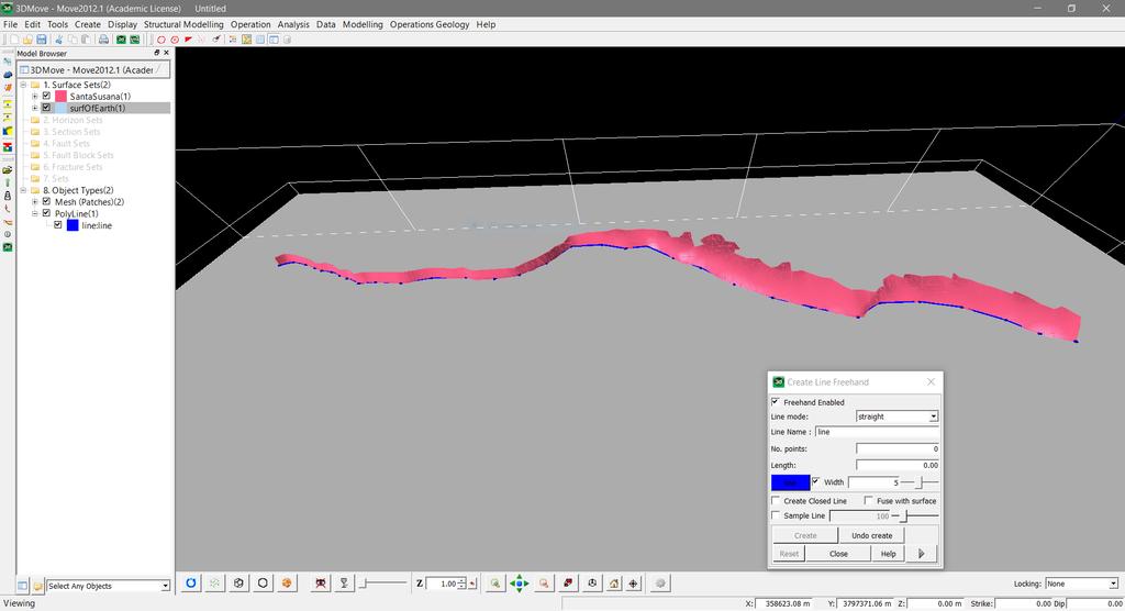
10 Flattening Topography: Two Choices Choice #2* *this is what I do Remove portion of fault surface above the datum The Good Fault orientation is unchanged Correct location in subsurface The Bad Fault trace is mislocated (for nonvertical faults) Surface area changes Less significant changes in compared to choice #1 Z = 0 Actual Fault Trace Model Fault Trace
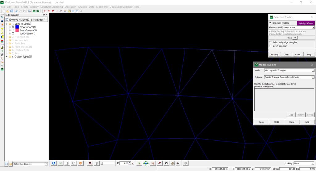
11 Software: 3DMove from Midland Valley
12
13
14
15
16
17

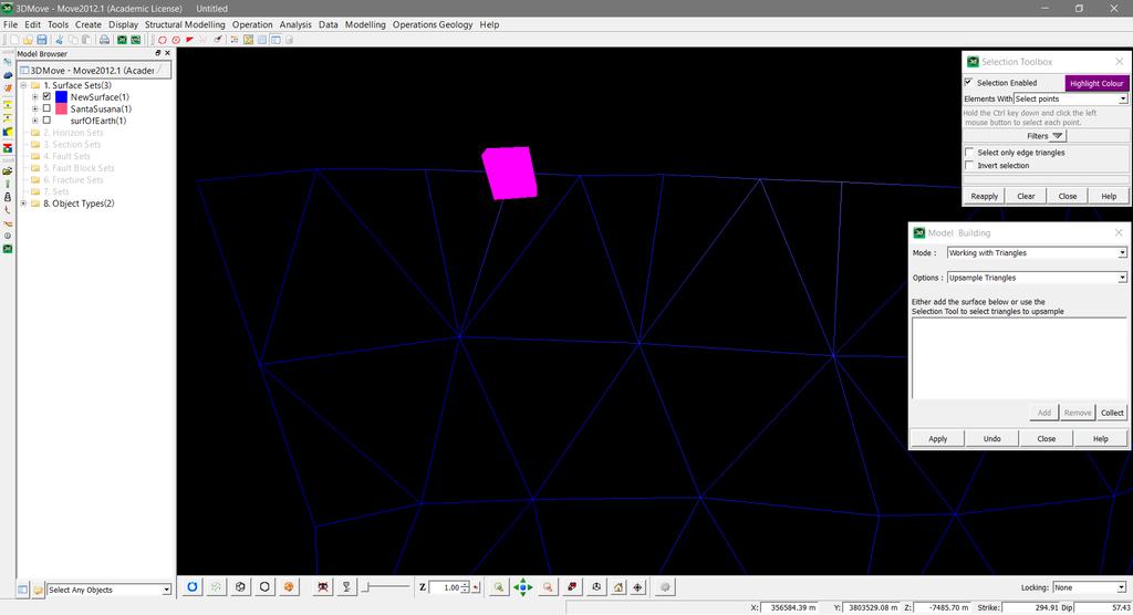
18 Unnecessary Triangles Poor aspect ratios
19
20
21
22
23
24
25
26
27
28
29
30

31 Creating good fault meshes is a combination of science and art Science: must fit the data Art: how good is good enough? Meshing: A Bit of an Art VERY time consuming Each fault: 1-3 hrs Depends on number of intersections Blind faults are easier Is this possible to automate? Maybe I have tried and failed many times Transverse Ranges Mesh Based on CFM5.0 Marshall et al. (2017, GRL) 79 Faults; 21,054 Elements Numerous subsurface fault intersections


32 Determination of Slip Rates/Rakes Such a dataset would almost certainly need to be model-derived Our groups have been doing this since Cooke & Marshall (2006, GRL) For recent examples, see Dorsett et al. SCEC Poster #218 Beyer et al. SCEC Poster #219 Getting pushy with the San Gorgonio Pass: Investigating active fault geometries with crustal deformation models Mechanical Models of Fault Slip Rates in the Imperial Valley, CA
 fixts.pl : makes a grouped surface into a single surface remtrgl.pl : used to find holes, and fix intersections checkfaulttop.")
33 Stuff to Share Scripts Useful for Meshing and Visualization ts2matlab.pl : converts t-surf to a MATLAB-friendly format plotmesh.m : plots a fault surface used with ts2matlab.pl ts2facet.pl : converts to facet format (FEM models) fixts.pl : makes a grouped surface into a single surface remtrgl.pl : used to find holes, and fix intersections checkfaulttop.pl : checks to make sure faults go to z=0 checkfaultbottom.pl : checks the maximum depth of faults mesh.pl : a simple planar or sinusoidal mesh generator Contact me if you think these would be of use
Annual Report 2000 Comparing Mechanical and Geodetic Models of Los Angeles Basin Faults. Amherst, MA Los Angeles, CA 90089
 Annual Report 2000 Comparing Mechanical and Geodetic Models of Los Angeles Basin Faults Michele Cooke Susan Owen University of Massachsetts Amherst University of Southern California Amherst, MA 01003-5820
Jack Loveless Department of Geosciences Smith College
 Geodetic constraints on fault interactions and stressing rates in southern California Jack Loveless Department of Geosciences Smith College jloveless@smith.edu Brendan Meade Department of Earth & Planetary
involved in multiple state-wide re-evaluations of seismic risk by the State of California.
 Resume Andreas Plesch CONTACT INFORMATION Andreas Plesch, 39 Barbara Rd., Waltham, MA 02453 Tel. +1-617-496-9746 (office), Fax. +1-617-495-7660 (office) email: andreas_plesch@gmail.com SUMMARY Ph.D. educated
Today: Basic regional framework. Western U.S. setting Eastern California Shear Zone (ECSZ) 1992 Landers EQ 1999 Hector Mine EQ Fault structure
 1992 Landers EQ 1999 Hector Mine EQ Fault structure") Today: Basic regional framework Western U.S. setting Eastern California Shear Zone (ECSZ) 1992 Landers EQ 1999 Hector Mine EQ Fault structure 1 2 Mojave and Southern Basin and Range - distribution of strike-slip
Today: Basic regional framework Western U.S. setting Eastern California Shear Zone (ECSZ) 1992 Landers EQ 1999 Hector Mine EQ Fault structure 1 2 Mojave and Southern Basin and Range - distribution of strike-slip
John Shaw CRUSTAL DEFORMATION MODEL: OBLIQUE CONVERGENCE IN THE INNER CALIFORNIA BORDERLANDS ACCOMMODATED BY ACTIVE STRIKE-SLIP AND REVERSE FAULTS
 CRUSTAL DEFORMATION MODEL: OBLIQUE CONVERGENCE IN THE INNER CALIFORNIA BORDERLANDS ACCOMMODATED BY ACTIVE STRIKE-SLIP AND REVERSE FAULTS August 2013 SONGS SSC SSHAC Workshop # 2 (August 12-14, 2013) Crustal
Kinematics of the Southern California Fault System Constrained by GPS Measurements
 Title Page Kinematics of the Southern California Fault System Constrained by GPS Measurements Brendan Meade and Bradford Hager Three basic questions Large historical earthquakes One basic question How
distinct east-west striking, echelon segments (Figure 1; Shaw and Shearer, 1999). Although
. Although") Mechanical validation of the three-dimensional intersection geometry between the Puente Hills blind-thrust system and the Whittier fault, Los Angeles, California W. A. Griffith and M. L. Cooke The University
Mechanical validation of the three-dimensional intersection geometry between the Puente Hills blind-thrust system and the Whittier fault, Los Angeles, California W. A. Griffith and M. L. Cooke The University
EARTHQUAKE LOCATIONS INDICATE PLATE BOUNDARIES EARTHQUAKE MECHANISMS SHOW MOTION
 6-1 6: EARTHQUAKE FOCAL MECHANISMS AND PLATE MOTIONS Hebgen Lake, Montana 1959 Ms 7.5 1 Stein & Wysession, 2003 Owens Valley, California 1872 Mw ~7.5 EARTHQUAKE LOCATIONS INDICATE PLATE BOUNDARIES EARTHQUAKE
EVALUATION OF TSUNAMI RISK FOR COASTAL SOUTHERN CALIFORNIA CITIES. Appendix A - Figures
 EVALUATION OF TSUNAMI RISK FOR COASTAL SOUTHERN CALIFORNIA CITIES Appendix A - Figures Figure 1.Map showing major faults of the southern California region. Northwest-trending faults are rightslip in character.
SCEC Community Fault and Velocity Models and how they might contribute to the DCPP seismic hazard assessment. Andreas Plesch Harvard University
 SCEC Community Fault and Velocity Models and how they might contribute to the DCPP seismic hazard assessment Andreas Plesch Harvard University SCEC Unified Structural Representation (USR) The SCEC USR
San Gorgonio Pass Special Fault Study Area
 San Gorgonio Pass Special Fault Study Area Michele Cooke, David Oglesby and Doug Yule Whitney Behr, Kim Blisniuk, Jim Brune, Sarah Carena, Judi Chester, Gary Fuis, Thomas Goebel, Peter Gold, Egill Hauksson,
UNDERSTANDING GEOLOGIC M APS
 Name: Lab Section: work in groups, but each person turns in his/her own GEOSCIENCE 001 L AB UNDERSTANDING GEOLOGIC M APS Geologic maps are colorful and even beautiful, but they also contain an amazing
Interseismic deformation associated with three-dimensional faults in the greater Los Angeles region, California
 JOURNAL OF GEOPHYSICAL RESEARCH, VOL. 114,, doi:10.1029/2009jb006439, 2009 Interseismic deformation associated with three-dimensional faults in the greater Los Angeles region, California Scott T. Marshall,
Empirical Green s Function Analysis of the Wells, Nevada, Earthquake Source
 Nevada Bureau of Mines and Geology Special Publication 36 Empirical Green s Function Analysis of the Wells, Nevada, Earthquake Source by Mendoza, C. 1 and Hartzell S. 2 1 Centro de Geociencias, Universidad
SONGS SSC. Tom Freeman GeoPentech PRELIMINARY RESULTS
 SONGS SSC Tom Freeman GeoPentech PRELIMINARY RESULTS Focused Questions Summarize the tectonic setting What is the seismogenic thickness? Are you including deep ruptures in the upper mantle (~30 km)? Do
Fault slip rates and interseismic deformation in the western Transverse Ranges, California
 JOURNAL OF GEOPHYSICAL RESEARCH: SOLID EARTH, VOL. 118, 4511 4534, doi:1.12/jgrb.5312, 213 Fault slip rates and interseismic deformation in the western Transverse Ranges, California Scott T. Marshall,
A century of oil-field operations and earthquakes in the greater Los Angeles Basin, southern California
 A century of oil-field operations and earthquakes in the greater Los Angeles Basin, southern California Egill Hauksson 1, Thomas Göbel 1, Jean-Paul Ampuero 1, and Elizabeth Cochran 2 Downloaded 06/03/15
In this lab, we will study and analyze geologic maps from a few regions, including the Grand Canyon, western Wyoming, and coastal California.
 Name: Lab Section: work in groups, but each person turns in his/her own GEOSCIENCE 001 LAB UNDERSTANDING GEOLOGIC MAPS Geologic maps are colorful and even beautiful, but they also contain an amazing amount
Effects of Surface Geology on Seismic Motion
 4 th IASPEI / IAEE International Symposium: Effects of Surface Geology on Seismic Motion August 23 26, 2011 University of California Santa Barbara LONG-PERIOD (3 TO 10 S) GROUND MOTIONS IN AND AROUND THE
Seismic Reflection Views of the 1994 Northridge Earthquake Hypocentral Region Using Aftershock Data and Imaging Techniques
 Seismic Reflection Views of the 1994 Northridge Earthquake Hypocentral Region Using Aftershock Data and Imaging Techniques SERGIO CHÁVEZ-PÉREZ and JOHN N. LOUIE SEISMOLOGICAL LABORATORY/174, MACKAY SCHOOL
Mechanical fault interaction within the Los Angeles Basin: A two-dimensional analysis using mechanical efficiency
 JOURNAL OF GEOPHYSICAL RESEARCH, VOL. 107, NO. B7, 10.1029/2001JB000542, 2002 Mechanical fault interaction within the Los Angeles Basin: A two-dimensional analysis using mechanical efficiency Michele L.
Stress modulation on the San Andreas fault by interseismic fault system interactions Jack Loveless and Brendan Meade, Geology, 2011
 Stress modulation on the San Andreas fault by interseismic fault system interactions Jack Loveless and Brendan Meade, Geology, 2011 A three step process: 1 - Assimilate plate boundary wide GPS data into
Chapter 15 Structures
 Chapter 15 Structures Plummer/McGeary/Carlson (c) The McGraw-Hill Companies, Inc. TECTONIC FORCES AT WORK Stress & Strain Stress Strain Compressive stress Shortening strain Tensional stress stretching
GROUND MOTION TIME HISTORIES FOR THE VAN NUYS BUILDING
 GROUND MOTION TIME HISTORIES FOR THE VAN NUYS BUILDING Prepared for the PEER Methodology Testbeds Project by Paul Somerville and Nancy Collins URS Corporation, Pasadena, CA. Preliminary Draft, Feb 11,
Earthquake Tectonics and Hazards on the Continents June Recognizing and characterizing strike-slip faults and earthquakes in USA
 2464-4 Earthquake Tectonics and Hazards on the Continents 17-28 June 2013 Recognizing and characterizing strike-slip faults and earthquakes in USA S. G. Wesnousky Univ. of Nevada USA Strike-slip Faults
Elastic Block Modeling of Fault Slip Rates across Southern California
 Macalester Journal of Physics and Astronomy Volume 4 Issue 1 Spring 2016 Article 3 May 2016 Elastic Block Modeling of Fault Slip Rates across Southern California Liam P. DiZio Macalester College, ldizio@macalester.edu
Comparison of Strain Rate Maps
 Comparison of Strain Rate Maps David T. Sandwell UNAVCO March 8, 2010 why strain rate matters comparison of 10 strain rate models new data required interseismic model velocity v(x) = V π tan 1 x D strain
Tectonic Seismogenic Index of Geothermal Reservoirs
 Tectonic Seismogenic Index of Geothermal Reservoirs C. Dinske 1, F. Wenzel 2 and S.A. Shapiro 1 1 Freie Universität Berlin 2 KIT Karlsruhe November 27, 2012 Introduction M max reservoir location -2.0 Barnett
IV. ENVIRONMENTAL IMPACT ANALYSIS E. GEOLOGY AND SOILS
 IV. ENVIRONMENTAL IMPACT ANALYSIS E. GEOLOGY AND SOILS INTRODUCTION This section evaluates potential impacts related to geology, including seismicity, and soils associated with development of the proposed
GROUND MOTION TIME HISTORIES FOR THE VAN NUYS BUILDING
 GROUND MOTION TIME HISTORIES FOR THE VAN NUYS BUILDING Prepared for the PEER Methodology Testbeds Project by Paul Somerville and Nancy Collins URS Corporation, Pasadena, CA March 7, Site Conditions The
1. Name at least one place that the mid-atlantic Ridge is exposed above sea level.
 Interpreting Tectonic and Bathymetric Maps. The purpose of this lab is to provide experience interpreting the bathymetry of the seafloor in terms of tectonic and geologic settings and processes. Use the
GPS Monitoring of the San Andreas Fault and Modeling of Slip Rate on the Mojave Section of the San Andreas Fault
 GPS Monitoring 1 GPS Monitoring of the San Andreas Fault and Modeling of Slip Rate on the Mojave Section of the San Andreas Fault By Nayeli Jimenez and Mischel Bartie PRISM Research Program Coordinator:
Regional deformation and kinematics from GPS data
 Regional deformation and kinematics from GPS data Jessica Murray, Jerry Svarc, Elizabeth Hearn, and Wayne Thatcher U. S. Geological Survey Acknowledgements: Rob McCaffrey, Portland State University UCERF3
Regional Geodesy. Shimon Wdowinski. MARGINS-RCL Workshop Lithospheric Rupture in the Gulf of California Salton Trough Region. University of Miami
 MARGINS-RCL Workshop Lithospheric Rupture in the Gulf of California Salton Trough Region Regional Geodesy Shimon Wdowinski University of Miami Rowena Lohman, Kim Outerbridge, Tom Rockwell, and Gina Schmalze
SUPPLEMENTARY INFORMATION
 SUPPLEMENTARY INFORMATION doi: 10.1038/ngeo739 Supplementary Information to variability and distributed deformation in the Marmara Sea fault system Tobias Hergert 1 and Oliver Heidbach 1,* 1 Geophysical
Automation of cross section construction and forward modelling of fault-bend folds from integrated map data
 Trabajos de Geología, Universidad de Oviedo, 30 : 63-68 (2010) Automation of cross section construction and forward modelling of fault-bend folds from integrated map data A. L. MCCOLLOCH 1*, M. P. BRAUNSCHEIDEL
Fault Specific, Dynamic Rupture Scenarios for Strong Ground Motion Prediction
 Fault Specific, Dynamic Rupture Scenarios for Strong Ground Motion Prediction H. Sekiguchi Disaster Prevention Research Institute, Kyoto University, Japan Blank Line 9 pt Y. Kase Active Fault and Earthquake
2.0 DATA COLLECTION AND LITERATURE REVIEW
 2.0 DATA COLLECTION AND LITERATURE REVIEW In order to perform the geotechnical evaluation, a comprehensive compilation and review of available publications, reports, and data was performed for all areas
Lack of continuity of the San Andreas Fault in southern California: Three-dimensional fault models and earthquake scenarios
 JOURNAL OF GEOPHYSICAL RESEARCH, VOL. 109,, doi:10.1029/2003jb002643, 2004 Lack of continuity of the San Andreas Fault in southern California: Three-dimensional fault models and earthquake scenarios Sara
Regional tectonic stress near the San Andreas fault in central and southern California
 GEOPHYSICAL RESEARCH LETTERS, VOL. 31, L15S11, doi:10.1029/2003gl018918, 2004 Regional tectonic stress near the San Andreas fault in central and southern California J. Townend School of Earth Sciences,
Deformation of Rocks. Orientation of Deformed Rocks
 Deformation of Rocks Folds and faults are geologic structures caused by deformation. Structural geology is the study of the deformation of rocks and its effects. Fig. 7.1 Orientation of Deformed Rocks
Nancy Natek The University of New Mexico
 Constraints on the SCEC 3D Velocity Model from Gravity Data: Two-Dimensional Gravity Modeling of the Central and Eastern Transverse Ranges in the Los Angeles Region Nancy Natek The University of New Mexico
Part 2 - Engineering Characterization of Earthquakes and Seismic Hazard. Earthquake Environment
 Part 2 - Engineering Characterization of Earthquakes and Seismic Hazard Ultimately what we want is a seismic intensity measure that will allow us to quantify effect of an earthquake on a structure. S a
Appendix O: Gridded Seismicity Sources
 Appendix O: Gridded Seismicity Sources Peter M. Powers U.S. Geological Survey Introduction The Uniform California Earthquake Rupture Forecast, Version 3 (UCERF3) is a forecast of earthquakes that fall
The Seismogenic Thickness of the Southern California Crust
 Bulletin of the Seismological Society of America, Vol. 94, No. 3, pp. 940 960, June 2004 The Seismogenic Thickness of the Southern California Crust by Julie J. Nazareth and Egill Hauksson Abstract The
to: Interseismic strain accumulation and the earthquake potential on the southern San
 Supplementary material to: Interseismic strain accumulation and the earthquake potential on the southern San Andreas fault system by Yuri Fialko Methods The San Bernardino-Coachella Valley segment of the
Earthquakes. Chapter Test A. Multiple Choice. Write the letter of the correct answer on the line at the left.
 Earthquakes Chapter Test A Multiple Choice Write the letter of the correct answer on the line at the left. 1. Stress that pushes a mass of rock in two opposite directions is called a. shearing. b. tension.
Stress and Strain. Stress is a force per unit area. Strain is a change in size or shape in response to stress
 Geologic Structures Geologic structures are dynamically-produced patterns or arrangements of rock or sediment that result from, and give information about, forces within the Earth Produced as rocks change
Surface changes caused by erosion and sedimentation were treated by solving: (2)
") GSA DATA REPOSITORY 214279 GUY SIMPSON Model with dynamic faulting and surface processes The model used for the simulations reported in Figures 1-3 of the main text is based on two dimensional (plane strain)
GSA DATA REPOSITORY 214279 GUY SIMPSON Model with dynamic faulting and surface processes The model used for the simulations reported in Figures 1-3 of the main text is based on two dimensional (plane strain)
STRIKE SLIP SPLAY USING DYNAMIC RUPTURE MODELS
 STRIKE SLIP SPLAY USING DYNAMIC RUPTURE MODELS Julian Lozos (PEER, UC Berkeley) SWUS GMC Workshop #2, Berkeley, CA, 24 October 2013 Outline Issues in the dynamics of fault branches. Advantages and disadvantages
From Earthquakes to Mountains: the Earth s Crust in Motion
 Dean s Freshman Honor Seminar (SCI 110) Eric Calais Associate Professor of Geophysics Purdue University Department of Earth and Atmospheric Sciences ecalais@purdue.edu http:/www.eas.purdue.edu/~calais
What We Know (and don t know)
") What We Know (and don t know) about the M5.1 La Habra Earthquake Dr. Robert Graves U.S. Geological Survey In collaboration with: Dr. Egill Hauksson and Dr. Thomas Göbel Caltech Dr. Elizabeth Cochran U.S.
What We Know (and don t know) about the M5.1 La Habra Earthquake Dr. Robert Graves U.S. Geological Survey In collaboration with: Dr. Egill Hauksson and Dr. Thomas Göbel Caltech Dr. Elizabeth Cochran U.S.
Appendix 6A Geologic Information about the Project Area prepared by Ninyo & Moore October 2008
 Appendix 6A Geologic Information about the Project Area prepared by Ninyo & Moore October 2008 Appendix 6A: Geologic Information about the Project Area 6A-1Existing Geologic and Subsurface Conditions
Earth Science, (Tarbuck/Lutgens) Chapter 10: Mountain Building
 Chapter 10: Mountain Building") Earth Science, (Tarbuck/Lutgens) Chapter 10: Mountain Building 1) A(n) fault has little or no vertical movements of the two blocks. A) stick slip B) oblique slip C) strike slip D) dip slip 2) In a(n) fault,
Earth Science, (Tarbuck/Lutgens) Chapter 10: Mountain Building 1) A(n) fault has little or no vertical movements of the two blocks. A) stick slip B) oblique slip C) strike slip D) dip slip 2) In a(n) fault,
2016 SCEC ANNUAL TECHNICAL REPORT - SCEC
 1 2016 SCEC ANNUAL TECHNICAL REPORT - SCEC Award 16065 Continuing to Evaluate 3D Fault Geometry in Special Fault Study Areas and to Update & Improve the SCEC Community Fault Model Craig Nicholson Marine
Application of three fault growth criteria to the Puente Hills thrust system, Los Angeles, California, USA
 Journal of Structural Geology 27 (2005) 1765 1777 www.elsevier.com/locate/jsg Application of three fault growth criteria to the Puente Hills thrust system, Los Angeles, California, USA Erik L. Olson*,
Using Earthscope and B4 LiDAR data to analyze Southern California s active faults
 Using Earthscope and B4 LiDAR data to analyze Southern California s active faults Exercise 8: Simple landscape morphometry and stream network delineation Introduction This exercise covers sample activities
GROUND MOTIONS FROM LARGE EARTHQUAKES (MW³7) ON THE SANTA MONICA MOUNTAIN THRUST AND HOLLYWOOD-SANTA MONICA-MALIBU FAULTS
 ON THE SANTA MONICA MOUNTAIN THRUST AND HOLLYWOOD-SANTA MONICA-MALIBU FAULTS") GROUND MOTIONS FROM LARGE EARTHQUAKES (MW³) ON THE SANTA MONICA MOUNTAIN THRUST AND HOLLYWOOD-SANTA MONICA-MALIBU FAULTS C K SAIKIA And P G SOMMERVILLE SUMMARY We have simulated ground motion parameters
GROUND MOTIONS FROM LARGE EARTHQUAKES (MW³) ON THE SANTA MONICA MOUNTAIN THRUST AND HOLLYWOOD-SANTA MONICA-MALIBU FAULTS C K SAIKIA And P G SOMMERVILLE SUMMARY We have simulated ground motion parameters
Assessing Measures of Fault Growth by Simulating Evolution of the Puente Hills Thrust System, Los Angeles
 Assessing Measures of Fault Growth by Simulating Evolution of the Puente Hills Thrust System, Los Angeles Erik L. Olson*, Michele L. Cooke Department of Geosciences, University of Massachusetts Amherst,
Lecture # 6. Geological Structures
 1 Lecture # 6 Geological Structures ( Folds, Faults and Joints) Instructor: Dr. Attaullah Shah Department of Civil Engineering Swedish College of Engineering and Technology-Wah Cantt. 2 The wavy undulations
General Geology - GEOL 1113 Section 005
 General Geology - GEOL 1113 Section 005 Instructor: Dr. Glen S. Mattioli, Professor Office: Ozark Hall 27B Office Hours: MW 10:30-12:00 & TR 11:00-12:00 Office Phone: 575-7295 Class Web Page http://comp.uark.edu/~mattioli/geol_1113.html
IV. ENVIRONMENTAL IMPACT ANALYSIS E. GEOLOGY AND SOILS
 IV. ENVIRONMENTAL IMPACT ANALYSIS E. GEOLOGY AND SOILS The following section is a summary of the geotechnical report conducted for the Proposed Project. The Geotechnical Engineering Investigation (the
Staple this part to part one of lab 6 and turn in. Lab 6, part two: Structural geology (analysis)
") Geology 101 Staple this part to part one of lab 6 and turn in Lab 6, part two: Structural geology (analysis) Recall that the objective of this lab is to describe the geologic structures of Cougar Mountain
Geology 101 Staple this part to part one of lab 6 and turn in Lab 6, part two: Structural geology (analysis) Recall that the objective of this lab is to describe the geologic structures of Cougar Mountain
High Resolution Topographic Mapping of Southern California with Optical Imagery. Report for SCEC Award #16147
 High Resolution Topographic Mapping of Southern California with Optical Imagery Report for SCEC Award #16147 Investigators: William Barnhart (University of Iowa) Michael Willis (CU Boulder) Rich Briggs
Simulating the recent evolution of the southern big bend of the San Andreas fault, Southern California
 JOURNAL OF GEOPHYSICAL RESEARCH, VOL. 116,, doi:10.1029/2010jb007835, 2011 Simulating the recent evolution of the southern big bend of the San Andreas fault, Southern California Michele L. Cooke 1 and
Syllabus and Course Description Geophysical Geodesy Fall 2013 GPH 411/611
 Syllabus and Course Description Geophysical Geodesy Fall 2013 GPH 411/611 Course Location: LME 422 Course Time: Tuesday & Thursday 12:00-1:15 Units: 3 Instructor Name: Bill Hammond Office Location: SEM
SOURCE MODELING OF RECENT LARGE INLAND CRUSTAL EARTHQUAKES IN JAPAN AND SOURCE CHARACTERIZATION FOR STRONG MOTION PREDICTION
 SOURCE MODELING OF RECENT LARGE INLAND CRUSTAL EARTHQUAKES IN JAPAN AND SOURCE CHARACTERIZATION FOR STRONG MOTION PREDICTION Kimiyuki Asano 1 and Tomotaka Iwata 2 1 Assistant Professor, Disaster Prevention
Geo736: Seismicity and California s Active Faults Introduction
 Geo736: Seismicity and California s Active Faults Course Notes: S. G. Wesnousky Spring 2018 Introduction California sits on the boundary of the Pacific - North American plate boundary (Figure 1). Relative
Updated Graizer-Kalkan GMPEs (GK13) Southwestern U.S. Ground Motion Characterization SSHAC Level 3 Workshop 2 Berkeley, CA October 23, 2013
 Southwestern U.S. Ground Motion Characterization SSHAC Level 3 Workshop 2 Berkeley, CA October 23, 2013") Updated Graizer-Kalkan GMPEs (GK13) Southwestern U.S. Ground Motion Characterization SSHAC Level 3 Workshop 2 Berkeley, CA October 23, 2013 PGA Model Our model is based on representation of attenuation
Updated Graizer-Kalkan GMPEs (GK13) Southwestern U.S. Ground Motion Characterization SSHAC Level 3 Workshop 2 Berkeley, CA October 23, 2013 PGA Model Our model is based on representation of attenuation
Simulated and Observed Scaling in Earthquakes Kasey Schultz Physics 219B Final Project December 6, 2013
 Simulated and Observed Scaling in Earthquakes Kasey Schultz Physics 219B Final Project December 6, 2013 Abstract Earthquakes do not fit into the class of models we discussed in Physics 219B. Earthquakes
Basin & Range / Mojave Desert
 Basin & Range / Mojave Desert Basin & Range vs. Great Basin 1 2/20/2016 An overview of the last horst Basin and Range / Mojave Desert Summary: Granitic, volcanic, marine sedimentary, non marine sedimentary,
Topography on Earthquake Motions in Sedimentary Basins
 TRANSPORTATION RESEARCH RECORD 1411 Effects of Three-Dimensional Bedrock Topography on Earthquake Motions in Sedimentary Basins ARTHUR FRANKEL Work being done at the U.S. Geological Survey on 3-D simulations
The SCEC Planning Cycle
 The SCEC Planning Cycle Director Recommends to Agencies (March) Presentation to BoD (February) Leadership Retreat (June) Science Plan Development (Summer) Annual Meeting; Science Plan Input (September)
Learning Objectives (LO) What we ll learn today:!
 What we ll learn today:!") Learning Objectives (LO) Lecture 13: Mountain Building Read: Chapter 10 Homework #11 due Tuesday 12pm What we ll learn today:! 1. Define the types of stress that are present in the crust! 2. Define the
Learning Objectives (LO) Lecture 13: Mountain Building Read: Chapter 10 Homework #11 due Tuesday 12pm What we ll learn today:! 1. Define the types of stress that are present in the crust! 2. Define the
John Baldwin and Brian Gray Lettis Consultants International, Inc. Alexis Lavine AMEC Josh Goodman and Janet Sowers Fugro Consultants, Inc.
 John Baldwin and Brian Gray Lettis Consultants International, Inc. Alexis Lavine AMEC Josh Goodman and Janet Sowers Fugro Consultants, Inc. December 1, 2011 Pacific Gas & Electric SSHAC Workshop 1 San
SUPPLEMENTARY INFORMATION
 SUPPLEMENTARY INFORMATION DOI: 1.138/NGEO177 The Long Precursory Phase of Most Large Interplate Earthquakes Supplementary Information Supplementary Methods 1. Data and Classification We select the earthquakes
Structural Style in the Peel Region, NWT and Yukon
 Structural Style in the Peel Region, NWT and Yukon Adriana Taborda* Husky Energy and University of Calgary, Calgary, AB Adriana.Taborda@huskyenergy.ca and Deborah Spratt University of Calgary, Calgary,
Apparent and True Dip
 Apparent and True Dip Cross-bedded building stone. The contact immediately below A appears to dip gently to the right, but at B, the contact appears to dip to the left. But it's not a syncline! Both of
Kinematic Waveform Inversion Study of Regional Earthquakes in Southwest Iberia
 Kinematic Waveform Inversion Study of Regional Earthquakes in Southwest Iberia Ana Domingues Under supervision of Prof. João Fonseca and Dr. Susana Custódio Dep. Physics, IST, Lisbon, Portugal November
San Andreas Movie Can It Happen?
 San Andreas Movie Can It Happen? Learning Objectives (LO) Lecture 14: Faults and Quakes Read: Chapter 10 and 11 Homework #12 due Thursday 12pm What we ll learn today:! 1. Compare strike-slip to dip-slip
Mechanics, slip behavior, and seismic potential of corrugated dip-slip faults
 JOURNAL OF GEOPHYSICAL RESEARCH, VOL. 117,, doi:10.1029/2011jb008642, 2012 Mechanics, slip behavior, and seismic potential of corrugated dip-slip faults Scott T. Marshall 1 and Anna C. Morris 2 Received
The effect of non-parallel thrust fault interaction on fold patterns
 Journal of Structural Geology 26 (2004) 905 917 www.elsevier.com/locate/jsg The effect of non-parallel thrust fault interaction on fold patterns Heather M. Savage*, Michele L. Cooke Geosciences Department,
ANALYSIS OF A SLOPE FAILURE IN AN OPEN PIT MINE USING TSLOPE
 ANALYSIS OF A SLOPE FAILURE IN AN OPEN PIT MINE USING TSLOPE 1. Background In 1996 a slope failure occurred at the Round Hill open pit mine, operated by Macraes Mining Company Ltd. The failure as shown
Separating Tectonic, Magmatic, Hydrological, and Landslide Signals in GPS Measurements near Lake Tahoe, Nevada-California
 Separating Tectonic, Magmatic, Hydrological, and Landslide Signals in GPS Measurements near Lake Tahoe, Nevada-California Geoffrey Blewitt, Corné Kreemer, William C. Hammond, & Hans-Peter Plag NV Geodetic
Constrained Fault Construction
 Constrained Fault Construction Providing realistic interpretations of faults is critical in hydrocarbon and mineral exploration. Faults can act as conduits or barriers to subsurface fluid migration and
Modelling Subduction Zone Seismogenic Hazards in Southeast Asia for Seismic Hazard Assessments
 Modelling Subduction Zone Seismogenic Hazards in Southeast Asia for Seismic Hazard Assessments Vicki-Ann Dimas 1,2 and Gary Gibson 3 1. Corresponding Author. Seismic Hazard Analyst, Seismology Research
Rotation of the Principal Stress Directions Due to Earthquake Faulting and Its Seismological Implications
 Bulletin of the Seismological Society of America, Vol. 85, No. 5, pp. 1513-1517, October 1995 Rotation of the Principal Stress Directions Due to Earthquake Faulting and Its Seismological Implications by
Widespread Ground Motion Distribution Caused by Rupture Directivity during the 2015 Gorkha, Nepal Earthquake
 Widespread Ground Motion Distribution Caused by Rupture Directivity during the 2015 Gorkha, Nepal Earthquake Kazuki Koketsu 1, Hiroe Miyake 2, Srinagesh Davuluri 3 and Soma Nath Sapkota 4 1. Corresponding
Structural Geology and Geology Maps Lab
 Structural Geology and Geology Maps Lab Mesa College Geology 101 Lab Ray Rector: Instructor Structural Geology Lab Pre-Lab Resources Pre-Lab Internet Links 1) Fundamentals of Structural Geology 2) Visualizing
SUPPLEMENTARY INFORMATION
 SUPPLEMENTARY INFORMATION Supplementary online material for Bai et al., (2). EHS3D MT data collection Broadband magnetotelluric (MT) data were recorded on profiles P, P2 and P4 in the frequency band -.5
APPENDIX IV.A Geotechnical Study
 City of Los Angeles February 2014 APPENDIX IV.A Geotechnical Study Technical Appendices Museum Square Office Building Draft Environmental Impact Report February 8, 2013 File No. 20477 5757 Wilshire, LLC
Overview of the Seismic Source Characterization for the Palo Verde Nuclear Generating Station
 Overview of the Seismic Source Characterization for the Palo Verde Nuclear Generating Station Scott Lindvall SSC TI Team Lead Palo Verde SSC SSHAC Level 3 Project Tuesday, March 19, 2013 1 Questions from
Integration of Seismic and Seismological Data Interpretation for Subsurface Structure Identification
 Integration of Seismic and Seismological Data Interpretation for Subsurface Structure Identification Iftikhar Ahmed Satti, and Wan Ismail Wan Yusoff Abstract The structural interpretation of a part of
Estimating fault slip rates, locking distribution, elastic/viscous properites of lithosphere/asthenosphere. Kaj M. Johnson Indiana University
 3D Viscoelastic Earthquake Cycle Models Estimating fault slip rates, locking distribution, elastic/viscous properites of lithosphere/asthenosphere Kaj M. Johnson Indiana University In collaboration with:
Simulations in the Los Angeles Basin
 83 Chapter 4 Simulations in the Los Angeles Basin This chapter reports the responses of steel moment-resisting frame (MRF) buildings to simulated earthquakes in the Los Angeles basin. I use broadband ground
Growth of fault-cored anticlines by combined mechanisms of fault slip and buckling
 1 2 3 4 5 6 7 8 9 10 11 12 13 14 15 16 17 18 19 20 21 22 23 24 25 26 27 28 29 30 Growth of fault-cored anticlines by combined mechanisms of fault slip and buckling Wen-Jeng Huang* Kaj M. Johnson Department
Measurements in the Creeping Section of the Central San Andreas Fault
 Measurements in the Creeping Section of the Central San Andreas Fault Introduction Duncan Agnew, Andy Michael We propose the PBO instrument, with GPS and borehole strainmeters, the creeping section of
LAB 5: THE EARTHQUAKE CYCLE
 NAME: LAB TIME: LAB 5: THE EARTHQUAKE CYCLE This lab will introduce you to the basic quantitative concepts of the earthquake cycle for a vertical strike-slip fault. Most of your time will be spent calculating
CONTENTS PREFACE. VII 1. INTRODUCTION VARIOUS TOPICS IN SEISMOLOGY TECTONICS PERTAINING TO EQ PREDICTION 5
 CONTENTS PREFACE. VII 1. INTRODUCTION.... 1 2. VARIOUS TOPICS IN SEISMOLOGY TECTONICS PERTAINING TO EQ PREDICTION 5 2.1. Spatial distribution of strong EQs. 5 2.1.1. Mapping of major seismic fracture zones
Learning goals - January 16, Describe the geometry of a fault (1) orientation of the plane (strike and dip) (2) slip vector
 orientation of the plane (strike and dip) (2) slip vector") Learning goals - January 16, 2012 You will understand how to: Describe the geometry of a fault (1) orientation of the plane (strike and dip) (2) slip vector Understand concept of slip rate and how it is
Learning goals - January 16, 2012 You will understand how to: Describe the geometry of a fault (1) orientation of the plane (strike and dip) (2) slip vector Understand concept of slip rate and how it is