7. SUMATRA. Petroleum Geology of Indonesia : Current Knowledge. Regular HAGI Course Yogyakarta, 2 6 August by : Awang Harun Satyana
|
|
|
- Gloria Caldwell
- 5 years ago
- Views:
Transcription


1 Petroleum Geology of Indonesia : Current Knowledge Regular HAGI Course Yogyakarta, 2 6 August SUMATRA Minangkabau architecture by : Awang Harun Satyana

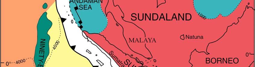
2 SUMATRA


3 Barber et al. (2005)


4 Simandjuntak and Barber (1996)
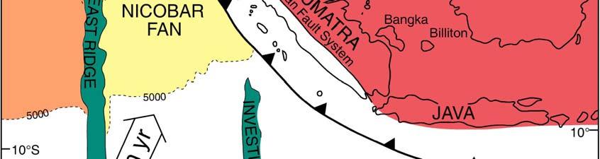
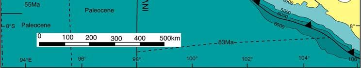
5 SUMATRA MAJOR TECTONIC ELEMENTS The Sunda Shelf borders the back arc basin to the east Asahan Arch, Bukit Tigapuluh Mountains and Lampung High partitions the back-arc basins The Bukit Barisan Range : Neogene Magmatic arc, separates the back-arc basins from West Sumatra forearc basins The Outer Arc Islands : accretion wedges The Sumatra trench: an oblique subduction zone
6 SUMATRA BACK ARC BASIN MODEL Koesoemadinata (2006)
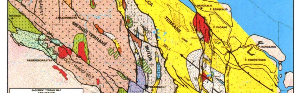
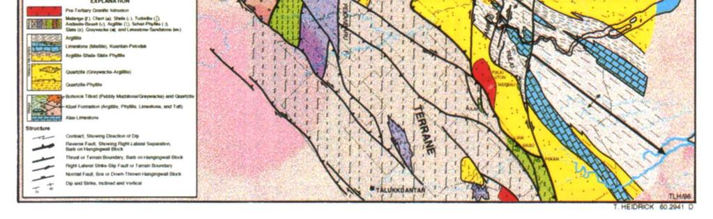
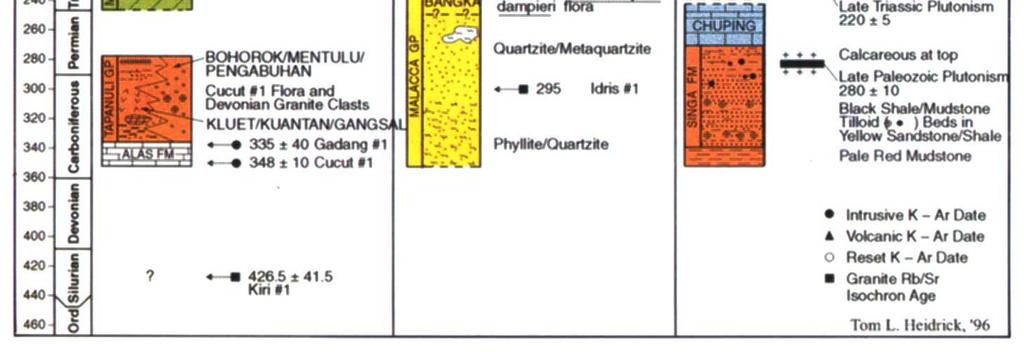
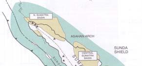
7 Sumatra Pre-Tertiary Basement Pre Tertiary rocks are exposed in the Barisan Range, Tigapuluh Mountains and Lampung High. Sumatra Pre-Tertiary rocks have been analyzed into separate terranes consisting of : highly tectonized Paleozoic and Mesozoic terranes Paleozoic to Mesozoic intrusive rocks Melange (ophiolitic rocks). Pre-Tertiary terranes are interpreted as a collage of Asian and Gondwanan microcontinents.


8 Microplate boundaries Pertamina and Beicip (1985)
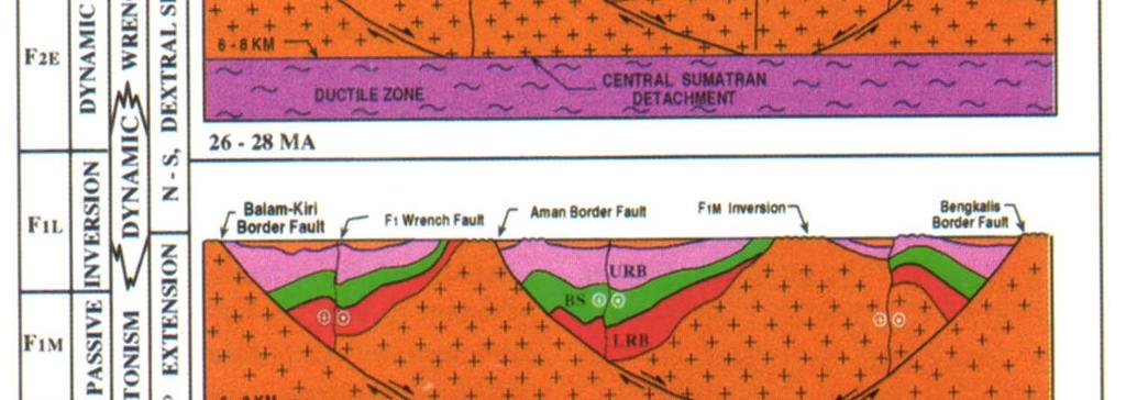
9 SUMATRA TERTIARY BASINS Back-arc and partly fore-arc basins are underlain by continental crust. The magmatic arc, Barisan Range, uplifted Pre-Tertiary rocks forms border to the basins. Paleogene rift basins extend from back-arc to fore-arc basins across the Bukit Barisan. Volcanism is limited to Paleogene (in the Southwest) and Plio-Pleistocene. The presence of the Great Trans-Sumatra wrench fault (Semangko Fault) along the Bukit Barisan.


10 Barber et al. (2005)


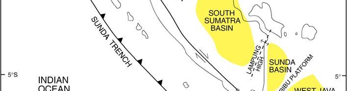
11 North Sumatra Basin Central Sumatra Basin South Sumatra Basin Sedimentary basins of Sumatra


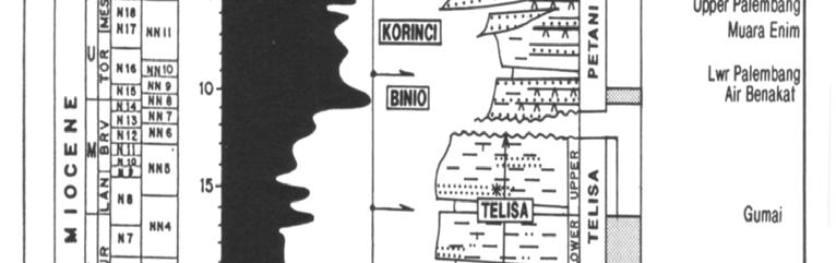
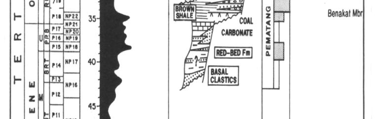
12 Stratigraphy of Sumatra back-arc basins Samuel and Gultom (1986)
13 Sumatra Tectono-Stratigraphic System From top to base : Syn-orogenic deposition in a back-arc basin : regressive (Mid-Miocene-Recent) rising Barisan Range clastic source Post-rift deposition in a shelfal basin : transgressive (Early Miocene) Sundaland clastics source and carbonates Syn-rift deposition in active rift-valley basins : one or more rift phases (?Eocene-Oligocene) local clastic source
14 Sumatra Major Fault System THE TRANS SUMATRA STRIKE-SLIP FAULT SYSTEM : active since Early Tertiary times THE PALEOGENE BASEMENT FAULT SYSTEM : This fault system resulted in the Paleogene graben-half-graben system with syn-rift deposition The Sumatra Paleogene Fault System extends SE to the NW Java basinal area
15 Sumatra Fault System Koesoemadinata (2006)
16 The Paleogene Basement Fault System This fault system consists of two main components N-S component WNW-ESE component In South Sumatra a NE-SW component is present This fault system cuts clear across the Barisan Range, beneath the fore-arc basin. This fault system is responsible for the development of Paleogene graben- halfgraben basin system with syn-rift deposition forming important oil kitchens.
")
17 Murphy (2000)

18 Sumatra Paleogene Fault System Koesoemadinata (2006)
19 Paleogene Basement Faults Explanation Moulds (1989): Faults are mainly N-S and was created due to the E-W directed extensional regime during the initial stage of the N-S directed stress caused by the subduction. Other explanation: transtensional faults due to the dextral wrenching movements of the Indian Ocean Plate relative to the Sunda continental plate
20 The Neogene Fold system The fold system is dominated by the WNW-ESE trending anticlinoria. Generally forming an en-echelon pattern. Explanation: Wrench movement along the NW-SE basement faults (related to the Paleogene graben system) (Harding,1988) Draping over uplifted blocks due to compressive regime of the subduction (Moulds, 1989)
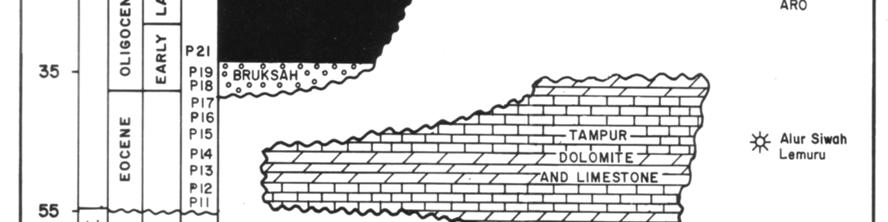
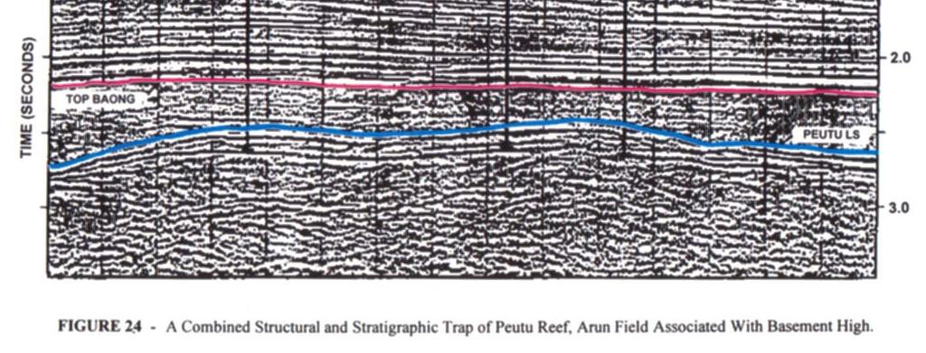
21 North Sumatra Basin The basin is notable for the first commercial oil field the Telaga Said field (discovered 1885) and the giant Arun gas field. The basin is extremely large and extends from just north of Medan northwards for several hundred kms into the Andaman Sea and across the Thailand Indonesia border. The Indonesian sector of the basin is bordered to the west by the Barisan Mountain thrust system and to the east by the stable Malacca platform. Onshore sector of the basin has been extensively explored, however, remaining potentials include : gas filled Peutu carbonate buildups, Belumai buildups on the Malacca shelf, Baong and Keutapang stratigraphic play, lowstand turbidite fan systems of middle Miocene (Tsukada et al., 1996; Nur aini et al. 1999), latest Oligocene Bampo fan systems, syn rift Parapat in graben deeps, Eocene Tampur carbonates (Ryacudu and Sjahbuddin, 1994). Relatively unexplored northern deepwater (> 1000 m water depth) sector of the basin merits further investigation.


22 NORTH SUMATRA BASINAL AREA Koesoemadinata (1994)

23 North Sumatra Crustal Section Koesoemadinata (1994)
24 Pertamina and Beicip (1985) North Sumatra Basin


25 Generalized physiography and productive HC discoveries of the North Sumatra basin Netherwood (2000)
")
26 Cross section across Barisan uplift and Southern NSB Pertamina and BPPKA (1996)


27 Cross section across North Sumatra Basin Pertamina and BPPKA (1996)


28 Cross section across NE corner of Barisan uplift Pertamina and BPPKA (1996)


29 North Sumatra Eocene Basin Configuration Davies (1984)
30 North Sumatra Basement Eocene Davies (1984)
31 North Sumatra Basin Oligocene Development Davies (1984)
32 North Sumatra Basin : Miocene Davies (1984)
33 North Sumatra Basin : Pliocene Davies (1984)
34 North Sumatra Basin : Present Davies (1984)

")


35 Pertamina and Beicip (1985)


36 Stratigraphic nomenclature of North Sumatra Basin Caughey and Wahyudi (1993)

37 North Sumatra Stratigraphy
38 North Sumatra Stratigraphic Diagram Synorogenic Post-rift Syn-rift
39 ENI (2002) Chronostratigraphic scheme for northern part of the North Sumatra Basin
40 North Sumatra Petroleum System Source Rocks and Migration Reservoir Rocks Clastics : Belumai Sands, Baong Sands, Keutapang, Seurula sands Carbonates : Early Miocene Reefs Seals Trapping Conditions Stratigraphic Structural
41 ENI (2002) Stratigraphy and Petroleum System of North Sumatra Basin


")

42 Petroleum system of North Sumatra basin Pertamina and BPPKA (1996)

43 Pertamina and BPPKA (1996)


44 Pertamina and BPPKA (1996)

")
45 BAONG Pertamina and BPPKA (1996)


46 Pertamina and BPPKA (1996)

47 Pertamina and BPPKA (1996)

48 Pertamina and BPPKA (1996)


49 Deepwater North Sumatra Basin ENI (2002)
50 Central Sumatra Basin The Central Sumatra Basin is the most prolific oil basin in SE Asia. Reserves estimates for the basin of 13 BBOE ultimately recoverable, of which 2.5 BBO remain to be recovered (Sujanto, 1997). The basin is mature with respect to HC exploration with a simple and essentially single petroleum system operating. New ideas are required if further fields are to be discovered and trend of declining production to be halted.

51 Basement tectonostratigraphic map Pertamina and BPPKA (1996)

52 Basement tectonostratigraphic correlation chart Pertamina and BPPKA (1996)
53 CENTRAL SUMATRA BASINAL AREA
54 Central Sumatra Basinal Area Regional Seismic Section Mertosono and Nayoan (1974)
55 Pertamina and Beicip (1985) Central Sumatra Basin

56 Central Sumatra Rift Basins


57 Central Sumatra Paleogene Rift Basins

")
58 Mertosono and Nayoan (1974)

")


")

59 Eocene Oligocene F1 (45 Ma-26 Ma) regional structure map Pertamina and BPPKA (1996)

")


60 Miocene Recent F2-F3 (26 Ma-0 Ma) structure map Pertamina and BPPKA (1996)

61 Pertamina and BPPKA (1996)


62 Heidrick and Aulia (1993)

")


63 Mertosono and Nayoan (1974)


64 Central Sumatra tectonostratigraphic chart Pertamina and BPPKA (1996)


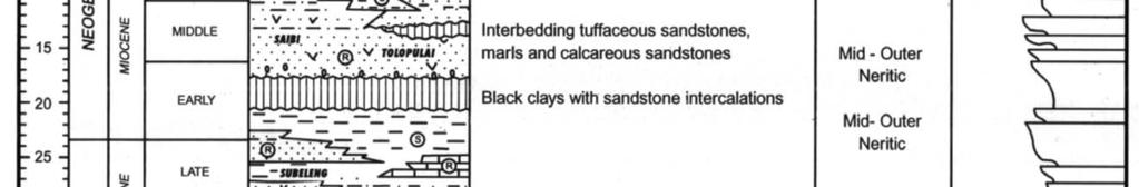
65 Stratigraphic nomenclature of Central Sumatra Basin Wain and Jackson (1995)

66 Central Sumatra Stratigraphic Diagram Atlas IPA (1991)
67 Central Sumatra Chronostratigraphy
68 Central Sumatra Petroleum System Central Sumatra is the most prolific petroleum in the Indonesian Basin. Source rocks and oil kitchen are exclusively synrift deposits (Brown shales of the Pematang Group). Reservoirs are exclusively clastics of the post rift transgressive Sihapas group. Trapping is provided by structural traps with stratigraphic components.

69 Central Sumatra petroleum system events chart Pertamina and BPPKA (1996)
70 Central Sumatra Basinal Area Miocene Duri Delta
71 Katz and Dawson (1997)
 Pertamina and BPPKA")
72 Cross plot of TOC and hydrogen index (HI) Pertamina and BPPKA (1996)
 in Brown Shale formation, Central Sumatra basin.")
73 Kerogen assemblage dominated by fluorescent amorphinite (A) and degraded, freshwater Botryococcus (FWA) in Brown Shale formation, Central Sumatra basin. Netherwood (2000)


74 Brown shale isopach map in Pematang trough Pertamina and BPPKA (1996)


75 Central Sumatra regional heat flow map Pertamina and BPPKA (1996)


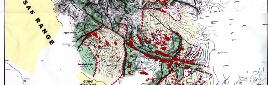
76 Paleogene depocenters, generalized structure and oil field distribution for the Central Sumatra basin Praptono et al. (1991)

77 Field distribution along regional, north-south trending dextral transcurrent faults in the coastal plains block of Central Sumatra Heidrick and Aulia (1993)

78 Netherwood (2000)
79 Sihapas reservoir of Bekasap formation in Minas field Pertamina and BPPKA (1996)
80 Central Sumatra Oil Fields Gas fields are practically non-existence Minas and Duri field are the main oil fields and can be classified as giant field.


81 F2 F3 Duri field and seismic profile Pertamina and BPPKA (1996)


82 F2 F3 East Kayuara field and seismic profile Pertamina and BPPKA (1996)

83 F2 F3 Kotabatak field and seismic profile Pertamina and BPPKA (1996)


84 F2 F3 Lalang field and seismic profile Pertamina and BPPKA (1996)


85 F2 F3 Libo SE field and seismic profile Pertamina and BPPKA (1996)


86 F2 F3 Lirik field and seismic profile Pertamina and BPPKA (1996)


87 F2 F3 Melibur field and seismic profile Pertamina and BPPKA (1996)


88 F2 F3 Minas field and seismic profile Pertamina and BPPKA (1996)


89 F2 F3 Parum field and seismic profile Pertamina and BPPKA (1996)


90 F2 F3 Petani field and seismic profile Pertamina and BPPKA (1996)
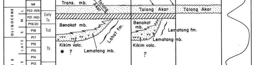
91 South Sumatra Basin The basin contains diverse petroleum systems, with both oil and gas being sourced from lacustrine and fluvio-deltaic terrestrial facies. Limited potential still remains for the traditional Talang Akar and Batu Raja formation plays. In contrast to the basin s mature oil status, the South Sumatra Basin is under-explored for gas, and contains good remaining gas potential in both new and existing successful plays. A further 6 to 10 TCF gas could be discovered in the basement, Talang Akar, and Batu Raja.


92 SOUTH SUMATRA BASINAL AREA Koesoemadinata (1994)

93 South Sumatra Crustal Cross-Section Koesoemadinata (1994)

94 South Sumatra Basin Outline
95 SOUTH SUMATRA BASINAL AREA JAMBI SUBBASIN NORTH PALEMBANG SUBBASIN CENTRAL PALEMBANG SUBBASIN SOUTH PALEMBANG SUBBASIN


96 South Sumatra structural framework Pertamina BPPKA (1996)


97 South Sumatra Basin Pertamina and Beicip (1985)

98 South Sumatra Sub-Basins


99 South Sumatra Paleogene Graben Halfgraben System
100 South Sumatra Paleogene Graben System The graben system is more complex than else where in Sumatra. In addition to the N-S-NW-SE system there is an additional NNE-SSW set. It consists mainly of half-grabens, facing west as well as east. The half-grabens are inverted with NW-SE set turning into a thrusted fold belts, described as flower structure. Ryacudu (2005)
101 Jambi Graben System A NNE-SSW complex graben system. Unique among the SW Sunda graben being not N-S oriented. Due to extension phase following a pre-existing major basement fault extending from Bukit Barisan to Singkep Island. This graben system becomes the site of the huge Jambi Depression in the Neogene.
 west east")
102 South Sumatra Basin Tectonic Development (1) west east Koesoemadinata (1994)
 west east")
103 South Sumatra Basin Tectonic Development (2) west east Koesoemadinata (1994)
")

104 Yulihanto and Sosrowidjoyo (1996) Generalized structural pattern of South Sumatra Basin


105 Basement terrains of South Sumatra Basin Ginger and Fielding (2005)


106 Structural styles of South Sumatra Basin Ginger and Fielding (2005)


107 South Sumatra surface structures Pertamina BPPKA (1996)
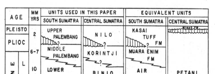


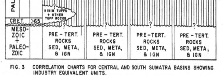


108 Stratigraphic Correlation of Central and South Sumatra Basins De Coster (1974)

")
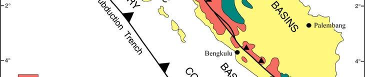
109 Pertamina and Beicip (1985)

110 South Sumatra Stratigraphic Diagram Atlas IPA (1991)
111 South Sumatra Petroleum System Source Rocks and Oil Kitchens Migration Reservoir Rocks : Basement Talangakar sands Baturaja carbonates Air Benakat sands Muara Enim sands Seals Trapping Condition Structural Traps Stratigraphic Carbonate Build-ups
112 South Sumatra Oil and Gas Fields (Examples of Fields) Fractured basements : Suban, Sumpal, Sambar. Talangakar sandstones : Talang Akar, Pendopo, Benakat, Limau fields, some fields in Jambi. Baturaja carbonates : Ramba, Air Serdang, Kaji- Semoga. Air Benakat sandstones : old fields, Kampong Minyak, Rambutan. Muara Enim sandstones : old fields


113 Exploration history of the South Sumatra Basin Ginger and Fielding (2005)


114 Cummulative discovery curve for the South Sumatra Basin split by reservoirs Ginger and Fielding (2005)

115 Kerogen of South Sumatra Basin Netherwood (2000)


116 Present day maturity map on top basement Ginger and Fielding (2005)

117 Netherwood (2000)

118 Pertamina and BPPKA (1996)

119 Pertamina and BPPKA (1996)


120 Pertamina and BPPKA (1996)


121 Suban giant gas field : producing gas from multiple reservoirs (igneous-metamorphic rocks, siliciclastics and carbonates) Pujasmadi et al. (2002)


122 Depth structure map of top Baturaja Formation Stratigraphy of South Sumatra Basin Leached skeletal packstone of Baturaja carbonate Kaji-Semoga field : big discovery in an over 100 year explored-basin Hutapea (2002)


123 Oil grouping of South Sumatra Basin Ginger and Fielding (2005)


124 Intra-Arc Basins of Sumatra OMBILIN PASEMAH Darman and Sidi (2000)

125
126 Ombilin Rift Basin Early Stage
127 Ombilin Basin Central Sumatra Middle Stage
128 Ombilin Basin, Central Sumatra Late Stage

129 Stratigraphy of Ombilin Basin, West Sumatra
130 Kamal (2000) Tectonic setting of Pasemah Block, South Suamtra


131 Kamal (2000) Subsurface stratigraphy of Pasemah Block, South Suamtra
132 SUMATRA FORE-ARC BASINS Meulaboh Basin Sibolga Basin Mentawai Basin Bengkulu Basin Western Sumatra fore-arc basin are still underlain by continental crust, and Paleogene graben system extends underneath the Neogene fore-arc basin.
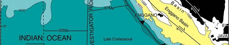
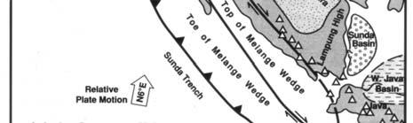
133 Fore-arc Basins Fore-arc basins have traditionally been considered poorly prospective for hydrocarbons due to : source-rock facies were unlikely to develop in these essentialy shallow, oxygenated, open-marine basins, Reservoir quality was assumed to be problem because nearby volcanic arcs and melange complex have supplied a predominance of poor-quality reservoirs, Geothermal gradients are relatively low. Six fore-arc basins of Western Indonesia have been drilled : Banyumas, South Central Java, Southwest Java, Bengkulu, Mentawai, Sibolga. The results, in some way, fuel optimism for the existence of economic petroleum reserves in the Western Indonesia fore-arcs.
134 West Sumatra Basin Petroleum System The fore-arc basins are considered cool basins. The fore-arc basins are less likely to contain hydrocarbons. Oil and gas occurrences are sourced from the synrift deposits, which experienced heating during the rifting process.


135 Simplified map of structural elements and HC occurrence in the Sumatra forearc Yulihanto et al. (1995)
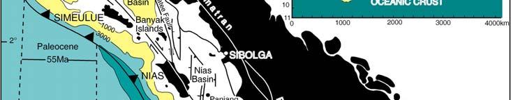
136 Bengkulu-Mentawai-Sibolga Basins (1) The Bengkulu basin is the mostwidely explored fore-arc basin in Indonesia. All Bengkulu basin carbonate targets proved to be waterfilled. Arwana-1 (Fina, 1992) encountered good oil shows and penetrated good marine sources of Oligo-Miocene shales which are within the oil window with GG of C/100 m (this is significantly higher than normal fore-arc setting). The origin of the Bengkulu basin is not strictly fore-arc, may originally have been in back-arc setting (Howles, 1986; Mulhadiono and Asikin, 1989; Hall et al., 1993; Yulihanto et al., 1995). The Bengkulu basin has a proven petroleum system for oil generation. It demonstrates a similar geology to the South Sumatra basin, with an undrilled Paleogene rift system that could feasibly contain lacustrine source rocks, and proven post-rift reservoir facies. Post-rift Miocene shales and some coals are proven source facies.
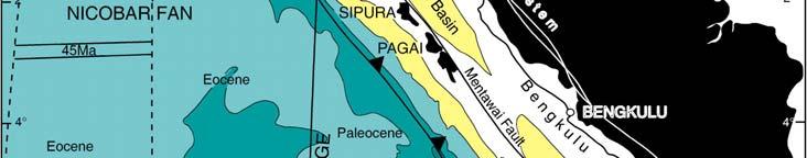
137 Bengkulu-Mentawai-Sibolga Basins (2) Fieldwork in the Mentawai Islands shows that the marine Oligocene graben fill in the Mentawai basin has source potential. Basin modelling suggests that these sediments may have entered oil window as early as the middle Miocene. Early Miocene buildups are considered potential reservoir target. Some wells contain biogenic methane shows (Yulihanto and Wiyanto, 1999). Suma-1, Singkel-1 (Union Oil), and Ibu Suma-1 (Caltex) wells of Sibolga basin encountered sub-economic quantities of biogenic gas (Dobson et al., 1998) middle Miocene carbonate build ups. The traps have sealing problem. Interbedded sands may show better biogenic gas prospects.

138 Bengkulu Basin Rifting Yulihanto et al. (1995)


139 Stratigraphy of Bengkulu fore-arc basin Yulihanto et al (1995)
140 Bengkulu Basin Stratigraphic Column Manna Subbasin Yulihanto et al. (1995)
 Tectonic")

141 Yulihanto et al (1995) Tectonic setting of Bengkulu fore-arc basin
")

142 Yulihanto (2000) Stratigraphy of Mentawai fore-arc basin
143 Yulihanto (2000) Subsurface stratigraphy of Mentawai fore-arc basin
")

144 vide Murphy (2000) Stratigraphy of Nias, Sibolga fore-arc basin


145 Seismic section and interpretation of the middle Miocene Ibu Suma buildup, Sibolga basin, north Sumatra fore-arc Dobson et al. (1998)
146 Fore-Arc Basins : Conclusions Fore-arc basins of Western Indonesia are poorly understood but their hydrocarbon potential is considered to be moderate to high (Netherwood, 2000). The Bengkulu basin experienced a history similar to that of the backarc basins : Paleogene rifting, Miocene structural modification, inversion and raised heat flow in Pliocene-Pleistocene times. The Bengkulu basin demonstrates mature source potential, sufficient heat flow for oil generation, and convincing oils shows in wells. Presence of biogenic gas and low geothermal gradient in Sibolga Basin are promising for future biogenic gas exploration. Interbedded sands within early Miocene reefs will be better sealed than reefs. Numerous oil and gas seepages in Bayah and Banyumas areas demonstrate the presence of active petroleum system. The presence of excellent Eocene reservoirs is promising. The areas are worth for further exploration.
THE NORTH SUMATERA BASIN : GEOLOGICAL FRAMEWORK & PETROLEUM SYSTEM REVIEW
 THE NORTH SUMATERA BASIN : GEOLOGICAL FRAMEWORK & PETROLEUM SYSTEM REVIEW By the Delegation of Indonesia : Bambang Wicaksono TM* Jonathan Setyoko H* Hermes Panggabean** * Lemigas ** PSG Krabi, 12-15 May
Sedimentary Cycle Best Practice: Potential Eo-Oligocene Sediments in Western Indonesia*
 Sedimentary Cycle Best Practice: Potential Eo-Oligocene Sediments in Western Indonesia* Mellinda Arisandy 1 and I Wayan Darma 1 Search and Discovery Article #11008 (2017)** Posted November 6, 2017 *Adapted
Stratigraphic Plays in Active Margin Basin: Fluvio-Deltaic Reservoir Distribution in Ciputat Half Graben, Northwest Java Basin*
 Stratigraphic Plays in Active Margin Basin: Fluvio-Deltaic Reservoir Distribution in Ciputat Half Graben, Northwest Java Basin* Ary Wahyu Wibowo 1, Astri Pujianto 1, Wisnu Hindadari 1, Arief Wahidin Soedjono
Depositional History and Petroleum Potential of Ombilin Basin, West Sumatra - Indonesia, Based on Surface Geological Data*
 Depositional History and Petroleum Potential of Ombilin Basin, West Sumatra - Indonesia, Based on Surface Geological Data* Yahdi Zaim 1, Litto Habrianta 2, Chalid I. Abdullah 1, Aswan 1, Yan Rizal 1, Nurcahyo
Chapter 3. Geology & Tectonics
 Chapter 3 Geology & Tectonics 3.1 Geology The general geological features of Indonesia are shown in Figure 3.1. The basement formation is metamorphic and it is intruded with plutonic formations. They are
EGAS. Ministry of Petroleum
 EGAS Ministry of Petroleum EGAS Ministry of Petroleum About The Block Location: N. El Arish offshore block is located in the extreme eastern part of the Egypt s economic water border and bounded from the
Blocks 31, 32, 33, 34, 35 & 36/03 Southeast Offshore Vietnam
 Blocks 31, 32, 33, 34, 35 & 36/03 Southeast Offshore Vietnam Block 31 32 33 34 35 36/03 Area (km 2) 5,036 4,440 4,630 4,700 4,630 2,950 Sea level (m) 20 20-30 30-40 50 50 50 Seismic 2D (km) 1,294 685 431
BALOCHISTAN FOLDBELT BASIN
 INTRODUCTION BALOCHISTAN FOLDBELT BASIN The Kharan-3 block is located in the Kharan Trough of Balochistan Basin. GEOLOGICAL SETTING The Balochistan Province is an Upper Cretaceous to Recent structurally
GEOLOGICAL SETTING OF SOUTH SUMATERA BASIN (SHALE HIDROCARBON BASINS IN INDONESIA)
") CCOP KIGAM Unconventional Oil and Gas Project: Mapping of Black Shale Formations for the Prediction of Shale resources (UnCon or UC Project) GEOLOGICAL SETTING OF SOUTH SUMATERA BASIN (SHALE HIDROCARBON
CCOP KIGAM Unconventional Oil and Gas Project: Mapping of Black Shale Formations for the Prediction of Shale resources (UnCon or UC Project) GEOLOGICAL SETTING OF SOUTH SUMATERA BASIN (SHALE HIDROCARBON
EGAS. Ministry of Petroleum
 EGAS Ministry of Petroleum EGAS Ministry of Petroleum About The Block Location: N. Thekah offshore block is located at about 56 km to the north of the Mediterranean shore line, 85 km to the north west
12 th 14 th October 2011, Yogyakarta, Indonesia
 12 th 14 th October 2011, Yogyakarta, Indonesia Azani Manaf M Razali Che Kob* M Akmal Affendi Adnan M Farizanuddin Jaapar Noor Farinda Salim Khairil Azhar Ghazali * Presenter Petroleum Management Unit,
A comparison of structural styles and prospectivity along the Atlantic margin from Senegal to Benin. Peter Conn*, Ian Deighton* & Dario Chisari*
 A comparison of structural styles and prospectivity along the Atlantic margin from Senegal to Benin Overview Peter Conn*, Ian Deighton* & Dario Chisari* * TGS, Millbank House, Surbiton, UK, KT6 6AP The
22 nd 25 th February 2011, Chiangmai, Thailand
 22 nd 25 th February 2011, Chiangmai, Thailand Mr. Robert Wong Hin Fatt M Razali Che Yaakob M Akmal Affendi Adnan Khairil Azhar Ghazali M Farizanuddin Jaapar Noor Farinda Salim* * Presenter Petroleum Management
11th Biennial International Conference & Exposition. Back arc, syn-rift, genetically linked, morpho-tectonic.
 Scope of Future Exploration in Andaman Basin, Genetically Linked with Producing Provinces of South-East Asia. Subir Das*, R.K.Srivastva E & D Directorate. Oil and Natural Gas Corporation Limited E-mail:
Perspectives from Offshore Argentina & Uruguay
 Perspectives from Offshore Argentina & Uruguay A Prospectivity Overview Hannah Kearns October 2018 Introduction Argentina Offshore License Round 1 14 blocks Argentina North, 24 Austral-Malvinas Offshore
Petroleum Geology and Exploration History of the Mergui Basin, THAILAND EPPM (P1) PROJECT
 PROJECT") Petroleum Geology and Exploration History of the Mergui Basin, THAILAND EPPM (P1) PROJECT KRABI, THAILAND 12 th May 2009 Contents of Presentation 1. Exploration History 1. Exploration History 2. General
Petroleum Geology and Exploration History of the Mergui Basin, THAILAND EPPM (P1) PROJECT KRABI, THAILAND 12 th May 2009 Contents of Presentation 1. Exploration History 1. Exploration History 2. General
2 nd 5 th August 2010, Langkawi Island, Malaysia. Basin Assessment & Promotion, PREX, PMU
 2 nd 5 th August 2010, Langkawi Island, Malaysia Mr. Robert Wong Hin Fatt M Razali Che Yaakob M Akmal Affendi Adnan Noor Farinda Salim Khairil Azhar Ghazali M Farizanuddin Jaapar* Basin Assessment & Promotion,
MUHAMMAD S TAMANNAI, DOUGLAS WINSTONE, IAN DEIGHTON & PETER CONN, TGS Nopec Geological Products and Services, London, United Kingdom
 Geological and Geophysical Evaluation of Offshore Morondava Frontier Basin based on Satellite Gravity, Well and regional 2D Seismic Data Interpretation MUHAMMAD S TAMANNAI, DOUGLAS WINSTONE, IAN DEIGHTON
PROCEEDINGS, INDONESIAN PETROLEUM ASSOCIATION Forty-First Annual Convention & Exhibition, May 2017
 IPA17-369-SG PROCEEDINGS, INDONESIAN PETROLEUM ASSOCIATION Forty-First Annual Convention & Exhibition, May 2017 FACIES ANALYSIS OF LATE NEOGENE DEPOSIT: MARINE TO CONTINENTAL ENVIRONMENT OF THE MERAPI
II. REGIONAL GEOLOGY
 II. REGIONAL GEOLOGY 2.1. Regional Plate Tectonic Setting The geological history of the East Java basin is closely related to tectonic activity of the Southeast Asia especially the Western Indonesia region.
Controls on clastic systems in the Angoche basin, Mozambique: tectonics, contourites and petroleum systems
 P2-2-13 Controls on clastic systems in the Angoche basin, Mozambique: tectonics, contourites and petroleum systems Eva Hollebeek, Olivia Osicki, Duplo Kornpihl Schlumberger, London, UK Introduction Offshore
NORTH SUMATRA MERGUI BASIN CROSS BORDER CASE STUDY EPPM-CCOP PROGRESS REVIEW INDONESIAN TEAM STUDY
 NORTH SUMATRA MERGUI BASIN CROSS BORDER CASE STUDY EPPM-CCOP PROGRESS REVIEW INDONESIAN TEAM STUDY P1W3 2-5 AUGUST LANGKAWI, MALAYSIA PROGRESS REVIEW GRAVITY MAP OF NORTH SUMATRA BASIN INDONESIAN SEISMIC
REGIONAL GEOLOGY IN KHMER BASIN
 CONTENTS 1-Khmere Basin 2-Regional Geology Khmer Basin 3-Regime Tectonic 4-Seismic Database -a/ Acquisition Data -b/ Prospect Angkor -C/ Cross Section Seismic 5-Play Type -a/ Play Schematic -b/ Structure
3D Seismic Reservoir Characterization and Delineation in Carbonate Reservoir*
 3D Seismic Reservoir Characterization and Delineation in Carbonate Reservoir* M. N. Alamsyah 1, Bambang W. Handono 1, and Andri Syafriya 1 Search and Discovery Article #41760 (2016) Posted January 25,
Ministry of Oil and Minerals Petroleum Exploration & Production Authority BLOCK 80 (WADI SARR)
") Ministry of Oil and Minerals Petroleum Exploration & Production Authority BLOCK 80 (WADI SARR) The Wadi Sarr Block (80) occupies an area of 1961 km 2 on the Sayun- Masilah Basin in the central Yemen. Block
Ministry of Oil and Minerals Petroleum Exploration & Production Authority BLOCK 80 (WADI SARR) The Wadi Sarr Block (80) occupies an area of 1961 km 2 on the Sayun- Masilah Basin in the central Yemen. Block
Petroleum geology framework, West Coast offshore region
 Petroleum geology framework, West Coast offshore region James W. Haggart* Geological Survey of Canada, Vancouver, BC jhaggart@nrcan.gc.ca James R. Dietrich Geological Survey of Canada, Calgary, AB and
Structural Style and Tectonic Evolution of the Nakhon Basin, Gulf of Thailand
 Structural Style and Tectonic Evolution of the Nakhon Basin, Gulf of Thailand Piyaphong Chenrai Petroleum Geoscience Program, Department of Geology, Faculty of Science, Chulalongkorn University, Bangkok
Ministry of Oil and Minerals Petroleum Exploration & Production Authority BLOCK 6 (Iryam)
") Ministry of Oil and Minerals Petroleum Exploration & Production Authority BLOCK 6 (Iryam) The Iryam Block (6) occupies an area of 3,911 km 2 in the Sabatayn Basin in the province of Shabwah in central
Ministry of Oil and Minerals Petroleum Exploration & Production Authority BLOCK 6 (Iryam) The Iryam Block (6) occupies an area of 3,911 km 2 in the Sabatayn Basin in the province of Shabwah in central
Ministry of Oil and Minerals Petroleum Exploration & Production Authority BLOCK 85 (Al Uqlah North)
") Ministry of Oil and Minerals Petroleum Exploration & Production Authority BLOCK 85 (Al Uqlah North) The Al Uqlah North Block (85) occupies an area of 597 km 2 in the Sabatayn Basin in the province of Shabwah
Ministry of Oil and Minerals Petroleum Exploration & Production Authority BLOCK 85 (Al Uqlah North) The Al Uqlah North Block (85) occupies an area of 597 km 2 in the Sabatayn Basin in the province of Shabwah
Bulletin of Earth Sciences of Thailand. Evaluation of the Petroleum Systems in the Lanta-Similan Area, Northern Pattani Basin, Gulf of Thailand
 Evaluation of the Petroleum Systems in the Lanta-Similan Area, Northern Pattani Basin, Gulf of Thailand Sirajum Munira Petroleum Geoscience Program, Department of Geology, Faculty of Science, Chulalongkorn
entered a rapid development phase. Annual increased proven reserves are above 500 billion cubic meters (bcm) from 2003, and annual natural gas product
 from 2003, and annual natural gas product") (), entered a rapid development phase. Annual increased proven reserves are above 500 billion cubic meters (bcm) from 2003, and annual natural gas production has increased from 50bcm in 2000 to nearly
(), entered a rapid development phase. Annual increased proven reserves are above 500 billion cubic meters (bcm) from 2003, and annual natural gas production has increased from 50bcm in 2000 to nearly
Oil-oil correlation of the South Sumatra Basin reservoirs
 Vol. 6(5), pp. 54-61, May, 2015 DOI: 10.5897/JPGE 2013.0162 Article Number: E2428FD53192 ISSN 2I41-2677 Copyright 2015 Author(s) retain the copyright of this article http://www.academicjournals.org/jpge
Overview of Indonesian Geothermal System
 Overview of Indonesian Geothermal System The Resources Beyond High Enthalpy Magmatic/Volcanic Systems By Dr.Eng. Suryantini ITB 4/3/2017 1 Outline Current Condition of Indonesian Geothermal Resources and
The Late Tertiary Deep-Water Siliciclastic System of the Levant Margin - An Emerging Play Offshore Israel*
 The Late Tertiary Deep-Water Siliciclastic System of the Levant Margin - An Emerging Play Offshore Israel* Michael A. Gardosh 1, Yehezkel Druckman 2 and Binyamin Buchbinder 2 Search and Discovery Article
Luderitz Basin, Offshore Namibia: Farm-out Opportunity. APPEX, London, March 2015 Graham Pritchard, Serica Energy plc
 Luderitz Basin, Offshore Namibia: Farm-out Opportunity APPEX, London, March 2015 Graham Pritchard, Serica Energy plc Serica Luderitz Basin Namibia Introduction Serica (85%, operator) 17,384 km 2 acreage
Structure of the western Brooks Range fold and thrust belt, Arctic Alaska
 Trabajos de Geología, Universidad de Oviedo, 29 : 218-222 (2009) Structure of the western Brooks Range fold and thrust belt, Arctic Alaska J. DE VERA 1* AND K. MCCLAY 2 1Now at: Shell, Rijswijk, Netherlands.
10B. Petroleum Occurrences in Basins Analogous to the East African Rift System
 10B. Petroleum Occurrences in Basins Analogous to the East African Rift System Robert Kasande Principal Geologist Petroleum Exploration and Production Department, Ministry of Energy and Mineral Development,
Blocks offered in Sri Lanka s Second Licensing Round
 Blocks offered in Sri Lanka s Second Licensing Round Sri Lankan Main Basins Cauvery Basin Cauvery Deep Water sub-basin Mannar Basin 2 Structural Framework Sri Lanka Basins Cauvery & Mannar Basins were
Basin Analysis. Stra-graphy
 Basin Analysis Stra-graphy Basin Analysis Basin analysis integrates program sedimentological, stra-graphic, and tectonic principals to develop a full understanding of the rocks that fill sedimentary basins.
Structural Evolution of Banda Arc, Eastern Indonesia: As a Future Indonesian Main Oil and Gas Development*
 Structural Evolution of Banda Arc, Eastern Indonesia: As a Future Indonesian Main Oil and Gas Development* Zaenal Holis 1, Agung Shirly Ponkarn 2, Agung Gunawan 2, Shinta Damayanti 2, and Brahmantyo K.
Petroleum Systems (Part One) Source, Generation, and Migration
 Source, Generation, and Migration") Petroleum Systems (Part One) Source, Generation, and Migration GEOL 4233 Class January 2008 Petroleum Systems Elements Source Rock Migration Route Reservoir Rock Seal Rock Trap Processes Generation Migration
Petroleum Systems (Part One) Source, Generation, and Migration GEOL 4233 Class January 2008 Petroleum Systems Elements Source Rock Migration Route Reservoir Rock Seal Rock Trap Processes Generation Migration
Geology (Mellow) Hike, Santa Lucia Memorial Park February 16, I. Overview of Santa Lucia Range geology and tectonic history
 Hike, Santa Lucia Memorial Park February 16, I. Overview of Santa Lucia Range geology and tectonic history") Geology (Mellow) Hike, Santa Lucia Memorial Park February 16, 2015 I. Overview of Santa Lucia Range geology and tectonic history A. Basement Rocks 1. Salinian Block Rocks Sierra Nevada Type, continental
Geology (Mellow) Hike, Santa Lucia Memorial Park February 16, 2015 I. Overview of Santa Lucia Range geology and tectonic history A. Basement Rocks 1. Salinian Block Rocks Sierra Nevada Type, continental
F.H. NADER 1, PETROLEUM SYSTEMS MODELING CHALLENGES OF STRUCTURALLY COMPLEX FRONTIER BASINS: THE CASE OF THE LEVANT (EAST-MED) BASIN
 BASIN") PETROLEUM SYSTEMS MODELING CHALLENGES OF STRUCTURALLY COMPLEX FRONTIER BASINS: THE CASE OF THE LEVANT (EAST-MED) BASIN A PROPOSED INTEGRATED APPROACH F.H. NADER 1, J. Barabasch 2, L. Inati 1, M. Ducros
PETROLEUM SYSTEMS MODELING CHALLENGES OF STRUCTURALLY COMPLEX FRONTIER BASINS: THE CASE OF THE LEVANT (EAST-MED) BASIN A PROPOSED INTEGRATED APPROACH F.H. NADER 1, J. Barabasch 2, L. Inati 1, M. Ducros
Block 43B - Onshore Oman
 Block 43B - Onshore Oman SUMMARY Block 43B is an 11,967 km 2 area located along the coastal area of Oman north of the Hajar Mountains. This is an unexplored region, both geographically and stratigraphically.
BRIDGING THE CONVENTIONAL / UNCONVENTIONAL DIVIDE, AN INDONESIAN PERSPECTIVE
 BRIDGING THE CONVENTIONAL / UNCONVENTIONAL DIVIDE, AN INDONESIAN PERSPECTIVE Kim Morrison CEO, Lion Energy Good Oil Conference 2 Important notice and disclaimer Forward-looking statements Certain statements
Deepwater Hydrocarbon Potentialof Orange Basin, South Africa: An Untested Oil Play
 Deepwater Hydrocarbon Potentialof Orange Basin, South Africa: An Untested Oil Play Soumen Dasgupta*, Moumita Sengupta, Prem Kumar, Biswanath Ghosh, Dr. BNS Naidu anddr. Sudhir Mathur. Cairn India Limited,
Vail et al., 1977b. AAPG 1977 reprinted with permission of the AAPG whose permission is required for further use.
 Well 5 Well 4 Well 3 Well 2 Well 1 Vail et al., 1977b AAPG 1977 reprinted with permission of the AAPG whose permission is required for further use. Well 5 Well 4 Well 3 Well 2 Well 1 Vail et al., 1977b
Orphan Basin, Offshore Newfoundland: New seismic data and hydrocarbon plays for a dormant Frontier Basin
 Orphan Basin, Offshore Newfoundland: New seismic data and hydrocarbon plays for a dormant Frontier Basin Jerry Smee* G&G Exploration Consulting, 301 400-3rd Avenue SW, Calgary, AB, T2P 4H2 Sam Nader, Paul
Mesozoic Earth History
 Mesozoic Earth History The Mesozoic Era 251-66 MYA Breakup of Pangea Changes in air and oceanic currents Evolution of new terrestrial and marine life Opening of the Atlantic Ocean Basin Rocky Mountains
Geological Evolution of Bago-Yoma Basin, Onshore Myanmar*
 Geological Evolution of Bago-Yoma Basin, Onshore Myanmar* Seehapol Utitsan 1, Teekayu Benjawan 1, Suppakarn Thanatit 1, Wirote Wetmongkongorn 1, U. Soe Than 2, Khun Hline Myint 1, and Ler Bwe Wah 1 Search
Copyright McGraw-Hill Education. All rights reserved. No reproduction or distribution without the prior written consent of McGraw-Hill Education
 Copyright McGraw-Hill Education. All rights reserved. No reproduction or distribution without the prior written consent of McGraw-Hill Education Tibetan Plateau and Himalaya -southern Asia 11.00.a VE 10X
Answers: Internal Processes and Structures (Isostasy)
") Answers: Internal Processes and Structures (Isostasy) 1. Analyse the adjustment of the crust to changes in loads associated with volcanism, mountain building, erosion, and glaciation by using the concept
Answers: Internal Processes and Structures (Isostasy) 1. Analyse the adjustment of the crust to changes in loads associated with volcanism, mountain building, erosion, and glaciation by using the concept
7 Sedimentation and tectonics at a mid- Ordovician to Silurian active margin
 80 Mountain Building in Scotland 7 Sedimentation and tectonics at a mid- Ordovician to Silurian active margin 7.1 Introduction In mid-ordovician to Silurian times, the Grampian mountains underwent exhumation,
Figure 1: Location and bathymetry of the study area. Gulf of Guinea. Cameroon. Congo. Gabon. PGS/DGH Gabon MegaSurvey Coverage (35000Km 2 ) Eq.
 Eq.") Deepwater hydrocarbon prospectivity analysis of offshore North and South Gabon Muhammad S Tamannai (*), Thomas Hansen (1), Ron Borsato (1), Jennifer Greenhalgh (1) Martial-Rufin Moussavou (2) & Landry
Deepwater hydrocarbon prospectivity analysis of offshore North and South Gabon Muhammad S Tamannai (*), Thomas Hansen (1), Ron Borsato (1), Jennifer Greenhalgh (1) Martial-Rufin Moussavou (2) & Landry
Continental Margin Geology of Korea : Review and constraints on the opening of the East Sea (Japan Sea)
") Continental Margin Geology of Korea : Review and constraints on the opening of the East Sea (Japan Sea) Han-Joon Kim Marine Satellite & Observation Tech. Korea Ocean Research and Development Institute
Continental Margin Geology of Korea : Review and constraints on the opening of the East Sea (Japan Sea) Han-Joon Kim Marine Satellite & Observation Tech. Korea Ocean Research and Development Institute
Relinquishment Report
 Relinquishment Report Licence P1403 Block 13/22d Chevron North Sea Limited Korean National Oil Company Chevron North Sea Limited December 2009 1 SYNOPSIS... 3 2 INTRODUCTION. 3 2.1 Licence Terms.. 3 2.2
Bulletin of Earth Sciences of Thailand
 Quantitative Seismic Geomorphology of Early Miocene to Pleistocene Fluvial System of Northern Songkhla Basin, Gulf of Thailand Oanh Thi Tran Petroleum Geoscience Program, Department of Geology, Faculty
Pre-Feasibility Report
 Pre-Feasibility Report Project Details: The Block MB-OSN-2005/1 is a Saurashtra shallow water block situated between GS-OSN- 2003/1(NELP-V) in the west, C-37/C-43 PEL in the east and Saurashtra - Dahanu
Structural Geology of the Mountains
 Structural Geology of the Mountains Clinton R. Tippett Shell Canada Limited, Calgary, Alberta clinton.tippett@shell.ca INTRODUCTION The Southern Rocky Mountains of Canada (Figure 1) are made up of several
Reservoir Description using Hydraulic Flow Unit and Petrophysical Rock Type of PMT Carbonate Early Miocene of Baturaja Formation, South Sumatra Basin*
 Reservoir Description using Hydraulic Flow Unit and Petrophysical Rock Type of PMT Carbonate Early Miocene of Baturaja Formation, South Sumatra Basin* Jaka Radiansyah 1, Teddy E. Putra 1, Rienno Ismail
APPENDIX C GEOLOGICAL CHANCE OF SUCCESS RYDER SCOTT COMPANY PETROLEUM CONSULTANTS
 APPENDIX C GEOLOGICAL CHANCE OF SUCCESS Page 2 The Geological Chance of Success is intended to evaluate the probability that a functioning petroleum system is in place for each prospective reservoir. The
PETROLEUM GEOLOGY OF THE RUSSIAN FAR-EAST
 Contents - 1 PETROLEUM GEOLOGY OF THE RUSSIAN FAR-EAST CONTENTS PART I: INTRODUCTION TO THE RUSSIAN FAR EAST AND ITS STRUCTURAL DEVELOPMENT. Chapter 1. The Russian Far East: Introduction and Infrastructure.
Paleogene low stand deepwater canyon fill deposits in Mahanadi Offshore Basin: can it prove to be the elusive major hydrocarbon discovery?
 P-317 Paleogene low stand deepwater canyon fill deposits in Mahanadi Offshore Basin: can it prove to be the elusive major Summary *Pradipta Kumar Das & Sudipto Datta, ONGC Mahanadi Deepwater Offshore Basin
PROCEEDINGS, INDONESIAN PETROLEUM ASSOCIATION Thirtieth Annual Convention & Exhibition, August 2005
 IPA05-G-159 PROCEEDINGS, INDONESIAN PETROLEUM ASSOCIATION Thirtieth Annual Convention & Exhibition, August 2005 PETROLEUM GEOCHEMISTRY STUDY IN A SEQUENCE STRATIGRAPHIC FRAMEWORK IN THE SIMENGGARIS BLOCK,
Petroleum Potential of the Application Area L12-4
 Petroleum Potential of the Application Area L12-4 The Application Area (L12-4) is underlain by the western Officer Basin, beneath the Gunbarrel Basin. The general basin architecture is outlined in Figure
Future giant discovery in the Outeniqua Basin, offshore South Africa. Anongporn Intawong & Neil Hodgson
 Future giant discovery in the Outeniqua Basin, offshore South Africa Anongporn Intawong & Neil Hodgson Spectrum Geoscience 23 February 2017 1 Talk Outlines Structural framework & Evolution of the South
RWE Dea UK SNS Limited (50%), Faroe Petroleum (UK) Limited
, Faroe Petroleum (UK) Limited") 1. Licence information Licence Number P1975 Licence Round 27 th (2012) Licence Type Traditional Blocks 3/28c & 9/3e Licensees Work Programme 2. Synopsis RWE Dea UK SNS Limited (50%), Faroe Petroleum (UK)
1. Licence information Licence Number P1975 Licence Round 27 th (2012) Licence Type Traditional Blocks 3/28c & 9/3e Licensees Work Programme 2. Synopsis RWE Dea UK SNS Limited (50%), Faroe Petroleum (UK)
ANGOLA OFFSHORE LICENSING 2007 BLOCK 46
 AGOLA OFFHOR LICIG 2007 BLOCK 46 DATA BA AVAILABILITY Figure 1 shows the seismic data available on Block 46. Fig. 1 Commercial 2D surveys: esterngeco: 794 km. GX Technology: 116 km. Commercial 3D surveys:
Southern Songkhla Basin, Gulf of Thailand
 Architecture and Depositional Environment of Fluvial Systems of Southern Songkhla Basin, Gulf of Thailand Toan Manh Do Petroleum Geoscience Program, Department of Geology, Faculty of Science, Chulalongkorn
Strike-Slip Faults. ! Fault motion is parallel to the strike of the fault.
 Strike-Slip Faults! Fault motion is parallel to the strike of the fault.! Usually vertical, no hanging-wall/footwall blocks.! Classified by the relative sense of motion. " Right lateral opposite block
Topics Laramide Orogeny: Late Cretaceous to Early Eocene Reading: GSA DNAG volume 3, Ch. 6
 Topics Laramide Orogeny: Late Cretaceous to Early Eocene Reading: GSA DNAG volume 3, Ch. 6 Late Cretaceous to early Eocene New patterns developed 5 main regions Tectonic interpretations Post-Laramide events
MODELING OF MENTAWAI SUBDUCTION ZONE BASED ON GRAVITY DATA
 MODELING OF MENTAWAI SUBDUCTION ZONE BASED ON GRAVITY DATA I. M. Fairayanti 1, Irham, MN 2, H. Danusaputro 3 1,2,3 Department of Physics, Faculty of Science and Mathematics, Diponegoro University, Semarang
BACK TO BASICS WHY THE TORRES BASIN COULD BE A COMPANY MAKER Papua New Guinea :PPL326 A Frontier Basin
 BACK TO BASICS WHY THE TORRES BASIN COULD BE A COMPANY MAKER Papua New Guinea :PPL326 A Frontier Basin 1 Tertiary Carbonate/Clastic Prospects and Leads PNG_LNG Facility PPL326 has a large number of over
Structural Framework and Deep-Marine Depositional Environments of Miocene- Pleistocene Sequence in Western Offshore Myanmar
 P-58 Structural Framework and Deep-Marine Depositional Environments of Miocene- Pleistocene Sequence in Western Offshore Myanmar Mukesh Jain*, Prabal Shankar Das, Bidesh Bandyopadhyay Summary The western
Earth Science, (Tarbuck/Lutgens) Chapter 10: Mountain Building
 Chapter 10: Mountain Building") Earth Science, (Tarbuck/Lutgens) Chapter 10: Mountain Building 1) A(n) fault has little or no vertical movements of the two blocks. A) stick slip B) oblique slip C) strike slip D) dip slip 2) In a(n) fault,
Earth Science, (Tarbuck/Lutgens) Chapter 10: Mountain Building 1) A(n) fault has little or no vertical movements of the two blocks. A) stick slip B) oblique slip C) strike slip D) dip slip 2) In a(n) fault,
The Mesozoic. Wednesday, November 30, 11
 The Mesozoic Periods of the Mesozoic Triassic- First period of the Mesozoic era Jurassic Cretaceous- Last period of the Mesozoic era Breakup of Pangaea Stage one (Triassic) Rifting and volcanism, normal
Global Tectonics. Kearey, Philip. Table of Contents ISBN-13: Historical perspective. 2. The interior of the Earth.
 Global Tectonics Kearey, Philip ISBN-13: 9781405107778 Table of Contents Preface. Acknowledgments. 1. Historical perspective. 1.1 Continental drift. 1.2 Sea floor spreading and the birth of plate tectonics.
Geosciences Career Pathways (Including Alternative Energy)
") Geosciences Career Pathways (Including Alternative Energy) Shale Carbonates Clastics Unconventionals Geology Characterization and Production Properties of Gas Shales Geomechanics in International Shale
Geosciences Career Pathways (Including Alternative Energy) Shale Carbonates Clastics Unconventionals Geology Characterization and Production Properties of Gas Shales Geomechanics in International Shale
PROCEEDINGS, INDONESIAN PETROLEUM ASSOCIATION Thirty-Ninth Annual Convention and Exhibition, May 2015
 IPA15-SG-089 PROCEEDINGS, INDONESIAN PETROLEUM ASSOCIATION Thirty-Ninth Annual Convention and Exhibition, May 2015 STRUCTURAL INTERPRETATION OF TECTONICALLY ASSOCIATED NORMAL AND REVERSE FAULTS OF BUKIT
East Africa Transform Margin The View from Tanzania and Madagascar
 East Africa Transform Margin The View from Tanzania and Madagascar Richard Higgins and Mark Sofield 10 th PESGB/HGS Conference on African E & P, London, September 7-8, 2011 Acknowledgements Legal Notice:
RELINQUISHMENT REPORT FOR LICENCE P.1663, BLOCK 29/4b and 29/5e
 RELINQUISHMENT REPORT FOR LICENCE P.1663, BLOCK 29/4b and 29/5e Licence: P.1663 Blocks: 29/4b & 29/5e 25th Round Traditional Licence Operator: Ithaca Energy UK(Ltd) 100% Work Programme Summary The agreed
Geology & Geophysics Applied in Industry. EXERCISE 2: A Quick-Look Evaluation
 EXERCISE 2: A Quick-Look Evaluation You have been asked to perform a quick back-of-the-envelope evaluation of the blocks being offered off of Somewhereia. Is there enough potential that our company should
EGAS. Ministry of Petroleum and Mineral Resources EGAS
 EGAS 5 8 7 6 2 1 3 Block Summary Location: North Ras El Esh Offshore Block is located in the shallow waters of the Mediterranean Sea, at the outlet of Damietta Branch of the River Nile. The southern boundary
Evaluation of Neocomian Shale source rock In Komombo Basin, Upper Egypt
 Evaluation of Neocomian Shale source rock In Komombo Basin, Upper Egypt Abdelhady, A. 1, Darwish, M. 2, El Araby, A. 3 and Hassouba, A. 4 1 DEA Egypt, Cairo, Egypt 2 Geology Department, Faculty of Science,
Hydrocarbon Exploration of Mesozoic in Kutch Offshore Area
 6 th International Conference & Exposition on Petroleum Geophysics Kolkata 2006 Hydrocarbon Exploration of Mesozoic in Kutch Offshore Area Ram Krishna Singh 1, R.C. Agrawalla 2, D. P. Verma 3, A. K. Goel
Maturity Modeling of Gomin and South Gomin fields Southern Pattani Basin, Gulf of Thailand
 Maturity Modeling of Gomin and South Gomin fields Southern Pattani Basin, Gulf of Thailand Patinya Jaithan Petroleum Geoscience Program, Department of Geology, Faculty of Science, Chulalongkorn University,
The McCully gas field in southern New Brunswick was discovered in the year 2000 on a joint drilling exploration venture by Corridor Resources Inc.
 1 The McCully gas field in southern New Brunswick was discovered in the year 2000 on a joint drilling exploration venture by Corridor Resources Inc. and Potash Corporation of Saskatchewan. Located about
History of geology and research of the Jan Mayen Micro-Continent and its associated exploration risks.
 History of geology and research of the Jan Mayen Micro-Continent and its associated exploration risks. Anett Blischke, Iceland GeoSurvey Þórarinn S. Arnarson, Karl Gunnarsson, Iceland GeoSurvey The North-Dreki
Kilometre-Scale Uplift of the Early Cretaceous Rift Section, Camamu Basin, Offshore North-East Brazil*
 Kilometre-Scale Uplift of the Early Cretaceous Rift Section, Camamu Basin, Offshore North-East Brazil* Iain Scotchman 1 and Dario Chiossi 2 Search and Discovery Article #50183 (2009) Posted May 20, 2009
South Pyrenean foreland basin
 South Pyrenean foreland basin 1 7 South Pyrenean foreland basin 1 8 South-Pyrenean Foreland basin S N Fore-bulge deformation Piggy-back B. Thrust nappes Basement Vergés & al, 2002 decollement Syntectonic
Stratigraphy Seismic and sedimentation Development of Middle Baong Sand, Aru Field, North Sumatera Basin
 Journal of Geoscience, Engineering, Environment, and Technology Vol 01 No 01 2017 E-ISSN : 2541-5794 P-ISSN : 2503-216X Stratigraphy Seismic and sedimentation Development of Middle Baong Sand, Aru Field,
Airborne gravity gradiometer surveying of petroleum systems under Lake Tanganyika, Tanzania
 Airborne gravity gradiometer surveying of petroleum systems under Lake Tanganyika, Tanzania D. Roberts Beach Energy P. Roy Chowdhury CGG S. J. Lowe CGG A. N. Christensen CGG Outline Introduction Geology
Application of transient electromagnetic method (TEM) technique in South-East Asia: Case studies from onshore Sarawak and North Sumatra
 technique in South-East Asia: Case studies from onshore Sarawak and North Sumatra") , pp. 1 5 Application of transient electromagnetic method (TEM) technique in South-East Asia: Case studies from onshore Sarawak and North Sumatra Yuri Agafonov 1,*, Igor Buddo 1,3, Olga Tokareva 1, M.
, pp. 1 5 Application of transient electromagnetic method (TEM) technique in South-East Asia: Case studies from onshore Sarawak and North Sumatra Yuri Agafonov 1,*, Igor Buddo 1,3, Olga Tokareva 1, M.
PETROLEUM GEOLOGY AND GEOPHYSICS OF THE MOZAMBIQUE CHANNEL ANNOUNCEMENT
 PETROLEUM GEOLOGY AND GEOPHYSICS OF THE MOZAMBIQUE CHANNEL ANNOUNCEMENT Rusk, Bertagne & Associates are pleased to announce the completion of a three year study and the publication of a report entitled
Abstract. Introduction. Regional Setting. GCSSEPM to be published December 2003
 Shelf Margin Deltas and Associated Deepwater Deposits: Implications on Reservoir Distribution and Hydrocarbon Entrapment, Block VI-1, Ulleung Basin, East Sea, South Korea Sneider, John S. Sneider Exploration,
Integrated interpretation of Gravity & Magnetic data for delineation of sedimentary thickness in deepwater block of Andman Basin
 P-204 Integrated interpretation of Gravity & Magnetic data for delineation of sedimentary thickness in deepwater block of D. Saha*, C.S. Bahuguna, Kh. Nabakumar, G.Singh, Sudhir Kumar, and Kunal Niyogi,
Deciphering the fracture networks of carbonate reservoirs in northern Iraq. Graham Banks, PhD
 Deciphering the fracture networks of carbonate reservoirs in northern Iraq Graham Banks, PhD Calgary Carbonates Group, December 12th, 2011 2 ACKNOWLEDGEMENTS I thank WesternZagros (WZ) management and colleagues
Prospectivity of the Equatorial Conjugate Margins of Africa and South America
 Prospectivity of the Equatorial Conjugate Margins of Africa and South America Ron Borsato* 1, Jennifer Greenhalgh 1, Steve Wells 1, Rick Roberson 1, Carlos Fontes 2 1 PGS, 2 Geohub Contents Introduction
Horizontal Well Injector/Producer Pair Platong Field, Pattani Basin, Thailand*
 Horizontal Well Injector/Producer Pair Platong Field, Pattani Basin, Thailand* Abhiphat Pakdeesirote 1, Sonchawan Ackagosol 3, Sarayoot Geena 3, Nualjun Kitvarayut 3, Kenneth Lewis 2, Tom Tran 3, Nancy
Mountain Building. Mountain Building
 Mountain Building Mountain building has occurred during the recent geologic past American Cordillera the western margin of the Americas from Cape Horn to Alaska Includes the Andes and Rocky Mountains Alpine