GEOLOGICAL SETTING OF SOUTH SUMATERA BASIN (SHALE HIDROCARBON BASINS IN INDONESIA)
|
|
|
- Oswald Davidson
- 6 years ago
- Views:
Transcription
 GEOLOGICAL SETTING OF SOUTH SUMATERA BASIN (SHALE HIDROCARBON BASINS IN INDONESIA)")

1 CCOP KIGAM Unconventional Oil and Gas Project: Mapping of Black Shale Formations for the Prediction of Shale resources (UnCon or UC Project) GEOLOGICAL SETTING OF SOUTH SUMATERA BASIN (SHALE HIDROCARBON BASINS IN INDONESIA) UCM7 Bangkok, Wednesday 29 Mach RESEARCH AND DEVELOPMENT CENTER FOR OIL AND GAS TECHNOLOGY LEMIGAS AGENCY OF RESEARCH AND DEVELOPMENT FOR ENERGY AND MINERAL RESOURCES MINISTRY OF ENERGY AND MINERAL RESOURCES REPUBLIC OF INDONESIA
2 Outline Indonesia Shale Hydrocarbon Potential Basins South Sumatera Basin Geological Setting Tectonic Stratigrafi Major Structural Features Exploration Activities Resume


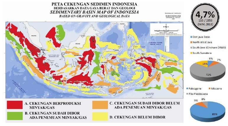
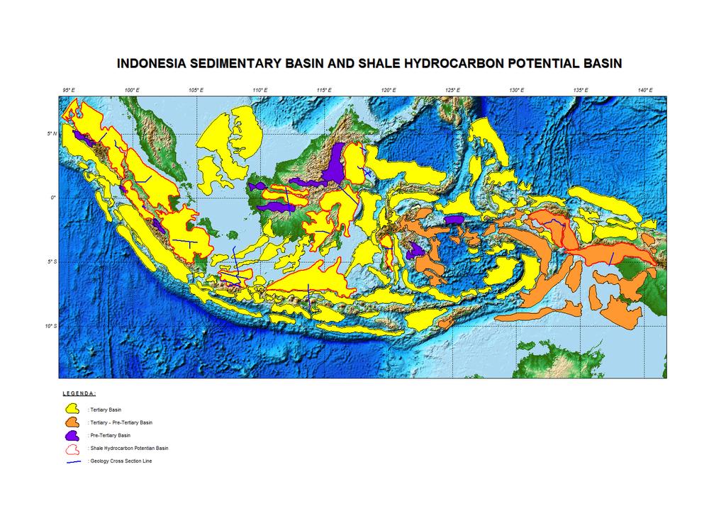
3 Indonesia Sedimentary Basins and Shale Hydrocarbon Potential Basin. The Promising Hydrocarbon Shale Resources in some Sedimentary Basin in Indonesia Geological Agency (2011)
4 South Sumatera Basin Based on the classification and estimation of potential shale hydrocarbon mentioned above, not all the potential for shale basins hydrocarbons done detailed studies Lemigas study in South Sumatra Basin, Pertamina conduct exploration activities in North Sumatra Basin and Centre of Geological Survey in Central Sumatra Basin as has been shown in this CCOP forum (UCM1-UCM5) Already written a brief report of the 14 basins that have the potential to shale hydrocarbon regarding location, tectonic setting and stratigraphy. In this opportunity will be present the geological setting and exploration activities in the South Sumatra Basin.
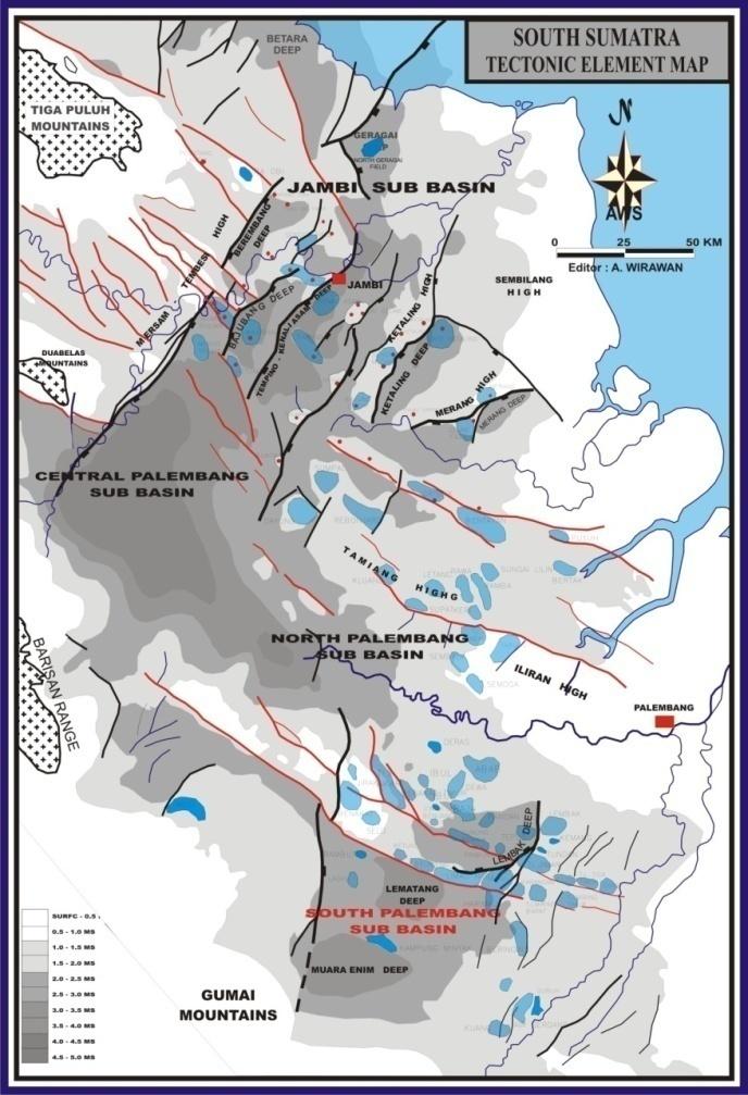
5 Location of South Sumatera Basin The geographical and tectonic setting of the Sumatran backarc basins. The volcanic arc follows approximately the trace of the Sumatran Fault (Davies, 1984) Lemigas, 2005.


6 Geological Setting South Sumatra basin is a back arc basin. formed by the movement of Hindia-Australia Oceanic Crust and Asia Continental Crust that have occurred since the Late Cretaceous to Early Tertiary. Filled the basin formed by deposition of sediment aged Eocene-Pliocene (Barber, 2005)

7 Structural Element (Ginger and Fielding, 2005).

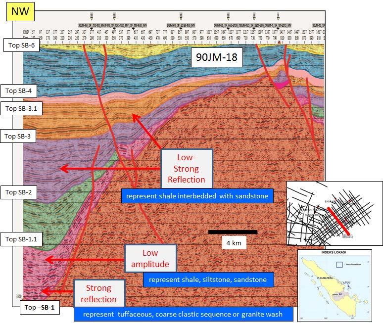
8 Regional Stratigraphy TARGET SHALE PLAY, Lahat/Lemat Formation and Talangakar Formation (rift/synrift phase) There are three tectonic mega sequences in South Sumatera Basin which, Syn-Ryft, Post-Rift, dan Synorogenic-Inversi (Ginger and Fielding, 2005).
 and Kamal (1999). LBF, Lebak Fault; KF, Kikim Fault, in Barber, 2005.")
9 Major Structural Feature Structure of the South Sumatra Basin showing the distribution of folds and faults, based on data from GRDC map sheets, De Coster (1974), Pulunggono (1986) Pulunggono et al. (1992) and Kamal (1999). LBF, Lebak Fault; KF, Kikim Fault, in Barber, during the Plio-Pleistocene strong compressional tectonics associated with uplifting of the volcanic arc to the west reactivated earlier structural feature and created northwest-southeast trending reverse faults and basement uplift. Barber, 2005.
10 Exploration Activities Exploration History Oil was first reported in the South Sumatra Basin near Muara Enim, to the east of Karangradja by Granberg in Since oil and gas field discoveries in the South Sumatera Basin, more than a hundred of oil and gas production fields recorded, about sixty of them still on production. Total oil proven reserve is 3.1 BBO and cumulative production is 2.3 BBO, while gas proven reserve is 6 TCF and cumulative production is 22 TCF. Since discovery of Kampung Minyak oil field in 1896, there are four peaks of activities : Shell-led BPM begun seismic exploration and drilling : Implementation of PSC system in south Sumatera, and followed by foreign oil company : Release of the best Pertamina reserved acreage to the industry now : Recent success Res related to the switch from solely oil exploration to an emphasis on gas Exploration Activities Exploration activities for non-conventional oil and gas started around the year 2011 by conducting a study in North Sumatra Basin and continued in the South Sumatra Basin in Until now there are 5 blocks WK MNK (non-conventional oil and gas) operated by national private and only at the exploration stage with locations in North Sumatra Basin, central Sumatra and South Sumatra. Blocks of non-conventional oil and gas was acquired since 2015.

11 Oil and Gas Non Conventional Working Area Status 2016 Block Year Basin Status MNK SUMBAGUT 17 MAY 2013 North Sumatera Explorasi MNK KISARAN 22 MAY 2015 North Sumatera Explorasi MNK SAKAKEMANG 22 MAY 2015 South Sumatera Explorasi MNK SELAT PANJANG 22 MAY 2015 Central Sumatera Explorasi MNK PALMERAH 22 MAY 2015 South Sumatera Explorasi
 (696 line) and 26 Well LEMIGAS used to study shale Hydrocarbon")
12 Data Aviability of South Sumatera Basin 521 Seismic Line (red line) 175 Seismic Line (blue line) (696 line) and 26 Well LEMIGAS used to study shale Hydrocarbon
13 Resume The South Sumatera Basin is considered as one of Mature back arc basin in western Indonesia. Laterally an area of approximately 119,000 km2 and filled sediments with an average thickness reaches meters (De Coster, 1974). The Tertiary half- graben and major faults of the South Sumatera Basin are oriented NE- SW, N-S and NW-SE. The South Sumatera Basin dynamic can be differentiated into 3 (three) tectonic mega sequences. Syn-rift Megasequence (40 29 Ma) Lahat/Lemat Fm Post Rift Megasequence ( 29-5 Ma ) Talang Akar Fm Syn-orogenic & Inversion Megasequence ( 5 Ma Present) As for shale hydrocarbon exploration target is Lahat/Lemat Formation, and Talangakar Formation. During the Plio-Pleistocene strong compressional tectonics associated with uplifting of the volcanic arc to the west reactivated earlier structural feature and created northwest-southeast (NW-SE) trending reverse faults and basement uplift. Based on exploration activity, the South Sumatra Basin is most active basin. The present-day play concept in Sumatra basins has resulted in exploration of deeper, older targets and shale hydrocarbon potential in this basin is promising.


14
15 BACK UP SLIDE
16 Indonesia Shale Hydrocarbon Potential Basin No Code Basin Name Basin Age Tectonic/Basin Type Area (Sq Km) Basin Status Formation Target SH 1 1 I-A North Sumatera Tertiary Basin Rift Valley Back Arc 118, Production Basin Bampo, Belumai, Baong Fm I-A Ombilin Tertiary Basin Rift Valley Intra Mountain 27, Drilled Basin, No discovery Sangkarewang Fm I-B Central Sumatera Tertiary Basin Rift Valley Back Arc 10, Production Basin Pematang, Telisa Fm I-A South Sumetera Tertiary Basin Rift Valley Back Arc 124, Production Basin Lemat/Lahat, Talangakar Fm I-A Northwest Java Tertiary Basin Rift Valley Back Arc 30, Production Basin Lower Cibulakan/ Talangakar Fm I-A Northeast Java Tertiary Basin Rift Valley Back Arc 116, Production Basin Ngimbang Fm. (Eocene) 7 41 I-E Ketungau- Mandai Tertiary Basin Rift Valley Foreland 11, Undrilled Basin Kantu Fm I-E Melawi Tertiary Basin Rift Valley Foreland 26, Drilled Basin, No discovery Pendawan, Selangkai, Silat Fm F-H Kutei Tertiary Basin Pasif Margin Deltaic 70,596.4 Production Basin Pamaluan, Pulubalang Fm F-H Tarakan Tertiary Basin Pasif Margin Deltaic 54, Production Basin Sembakung, Meliat, Tabul Fm I-E Barito Tertiary Basin Rift Valley Foreland 51, Production Basin Tanjung Fm I Sengkang Tertiary Basin Rift Valley 16, Production Basin Toraja/Malawa Fm F-E Bintuni Pratertiary - Tertiary Basin Rift Valley Foreland 66, Production Basin Ainim, Tipuma Fm F-E Akimeugah Pratertiary - Aiduna, Tipuma, Rift Valley Foreland 82, Drilled Basin, No discovery Tertiary Basin Kembelangan Fm.

17 Regional Tectonic Element Lemigas, 2005.

18 Regional Tectonic
19 Structural Element The Tertiary half- graben and major faults of the South Sumatera Basin are oriented NW-SE, SE-NW and N-S Numerous depocentre bounded by major faults Lahat/Lemat lacustrine shale and Talangakar shallow marine and deltaic coaly shale are the mature source rock Oil and gas are produced from the onshore South Sumatera Basin province. Shale from Lahat and Talangakar Formation were widely accepted as general source rock within province Lahat/Lemat and Talangakar source rock reservoir therefore are the main target. (David G., 2005)

20 Stratigraphy Diagrammatic crosssection to illustrate the tectonostratigraphic development of the South Sumatra Basin modified after Kingston (1988)..
21 SHALE FORMATION Lemat-Lahat Formation The Lemat Formation was formed during rifting phase and associated to extension tectonic, while Lahat Formation was formed in Pre-rift phase. The Lemat Formation (Benakat Shale) is composed of a series fining upward clastic sediments. They consist of multi fragments conglomerate, sandstones and shales which are deposited in land (alluvial) as fluvial to deltaic. De Coster (1974) in Gafoer, Cobrie dan Purnomo (1986) called the Lahat Formation as Lemat Formation and divided into two parts, they are granite wash at the lower part, and Benakat Member to the upper part. The Lemat Formation is unconformable overlays the Kikim Formation, and exposed in Cawang and Saling rivers. It consists of interbedded conglomeratic sandstones, sandstones, and intercalation of blackish claystones. These sequence showing fining and thinning upward succession. The Lemat Formation in Gumai Mountain can be differentiates into two rock units, that are tuffaceous shale unit and conglomeratic sandstone unit. The tuffaceous shale unit represents lower part of Lemat Formation as crop out in Cawang River. This unit consists of interbedded reddish claystones, dark claystones, tuffaceous shales with intercalation of thin parallel laminated of fine sandstones. It measuring thickness is 320 m. The reddish clay at some places was indicating the unconformity to above succession. The black claystones in Cawang River lies below red claystone with m thick, while sandy claystones (shale) has m thick. The conglomeratic sandstones unit that crop out in Saling River shows fining upward. The lower part of this unit is consists of sandy conglomerates, massive sandstones, and 2 8 m thick of claystone intercalation. Geochemical analysis of some hand specimens indicates TOC ( ) % with T Max 442o C (mature source rock).
22 SHALE FORMATION Talang Akar Formation The Talangakar Formation consists of conglomeratic sandstone, fine coarse sandstone, siltstone, claystone, and shale, with some coals intercalation. This unit was deposited during late period of syn-rift and early post-rift which was part of tectonic evolution of South Sumatera Basin. The lithologies of lower part of Talangakar Formation associated to fluvio-deltaic - shallow marine environment. While in the lower part of early Miocene, the environment and facies were changes to deltaic, shallow to deep marine indicating transgression event in South Sumatera Basin. The deposition of the upper part of Talangakar Formation followed by volcanic activity, and extensive marine environment. Those indicated by volcanic clastic and calcareous clastic sediments as exposed in Lahat area. Based on lithology composition, the Talangakar Formation can be divided into two members: Gritsand Member (GRM): consist of coarse clastic sediments as conglomeratic sandstones, quartz sandstones, and shales with coals intercalation. Sedimentary structures are bedded, cross bedded and parallel lamination. Transitional Member (TRM): consist of fine to medium clastic sediments as interbedded sandstones, shales, and dark grey silts with intercalation of coals and bituminous clay, glauconite minerals are abundance. It was deposited in transition to shallow marine during early Miocene. The Talangakar Formation is gradually overlain by reef limestone and sandy limestone of Baturaja Formation as open marine environment. Shale Unit Shale Unit represents upper Talangakar Formation, and called as Transitional Mamber (TRM) m thick, which was deposited in marine environment. This unit is exposed in Gumai Mountain consist of interbedded thin claystones, sandy claystones, and fine sandstones with calcareous sandstone nodules, and thin calcarenite limestone intercalation. It shows fining upward sequence with bed thickness (15 40) cm, parallel lamination, burrowed, and lenses/ lenticular sand. The claystone is dark grey-black in color, calcareous, massive, often containing molusc fragments, thinning upward with thickness (15 50) meters. The sandstone (10 15) cm, greenish grey, fine to medium grain, calcareous within calcareous sandstone nodules, massive, well sorted, containing molusc fragments, and has parallel lamination. Calcarenite (10 15 cm, brownish white, massive, rich of molusc fossil as intercalation in claystone,. Biostratigraphy analysis of CR-19 and SR-22 samples, indicate not older than early Miocene (not older than NN1) and deposited in terresterial environment, transition to shallow marine.
23


24 COMPOSITE SEISMIC LINE PAST THROUGH DEEP AREA (MERANG DEEP, EAST KETALING DAN KETALING) Structural Element Map of South Sumatera Basin Stratigraphy Column South Sumatera Basin
25
26

27 SHALE OUTCROP PHOTO
Sedimentary Cycle Best Practice: Potential Eo-Oligocene Sediments in Western Indonesia*
 Sedimentary Cycle Best Practice: Potential Eo-Oligocene Sediments in Western Indonesia* Mellinda Arisandy 1 and I Wayan Darma 1 Search and Discovery Article #11008 (2017)** Posted November 6, 2017 *Adapted
Depositional History and Petroleum Potential of Ombilin Basin, West Sumatra - Indonesia, Based on Surface Geological Data*
 Depositional History and Petroleum Potential of Ombilin Basin, West Sumatra - Indonesia, Based on Surface Geological Data* Yahdi Zaim 1, Litto Habrianta 2, Chalid I. Abdullah 1, Aswan 1, Yan Rizal 1, Nurcahyo
PROCEEDINGS, INDONESIAN PETROLEUM ASSOCIATION Forty-First Annual Convention & Exhibition, May 2017
 IPA17-369-SG PROCEEDINGS, INDONESIAN PETROLEUM ASSOCIATION Forty-First Annual Convention & Exhibition, May 2017 FACIES ANALYSIS OF LATE NEOGENE DEPOSIT: MARINE TO CONTINENTAL ENVIRONMENT OF THE MERAPI
Stratigraphic Plays in Active Margin Basin: Fluvio-Deltaic Reservoir Distribution in Ciputat Half Graben, Northwest Java Basin*
 Stratigraphic Plays in Active Margin Basin: Fluvio-Deltaic Reservoir Distribution in Ciputat Half Graben, Northwest Java Basin* Ary Wahyu Wibowo 1, Astri Pujianto 1, Wisnu Hindadari 1, Arief Wahidin Soedjono
THE NORTH SUMATERA BASIN : GEOLOGICAL FRAMEWORK & PETROLEUM SYSTEM REVIEW
 THE NORTH SUMATERA BASIN : GEOLOGICAL FRAMEWORK & PETROLEUM SYSTEM REVIEW By the Delegation of Indonesia : Bambang Wicaksono TM* Jonathan Setyoko H* Hermes Panggabean** * Lemigas ** PSG Krabi, 12-15 May
II. REGIONAL GEOLOGY
 II. REGIONAL GEOLOGY 2.1. Regional Plate Tectonic Setting The geological history of the East Java basin is closely related to tectonic activity of the Southeast Asia especially the Western Indonesia region.
Ministry of Oil and Minerals Petroleum Exploration & Production Authority BLOCK 6 (Iryam)
") Ministry of Oil and Minerals Petroleum Exploration & Production Authority BLOCK 6 (Iryam) The Iryam Block (6) occupies an area of 3,911 km 2 in the Sabatayn Basin in the province of Shabwah in central
Ministry of Oil and Minerals Petroleum Exploration & Production Authority BLOCK 6 (Iryam) The Iryam Block (6) occupies an area of 3,911 km 2 in the Sabatayn Basin in the province of Shabwah in central
Ministry of Oil and Minerals Petroleum Exploration & Production Authority BLOCK 85 (Al Uqlah North)
") Ministry of Oil and Minerals Petroleum Exploration & Production Authority BLOCK 85 (Al Uqlah North) The Al Uqlah North Block (85) occupies an area of 597 km 2 in the Sabatayn Basin in the province of Shabwah
Ministry of Oil and Minerals Petroleum Exploration & Production Authority BLOCK 85 (Al Uqlah North) The Al Uqlah North Block (85) occupies an area of 597 km 2 in the Sabatayn Basin in the province of Shabwah
BALOCHISTAN FOLDBELT BASIN
 INTRODUCTION BALOCHISTAN FOLDBELT BASIN The Kharan-3 block is located in the Kharan Trough of Balochistan Basin. GEOLOGICAL SETTING The Balochistan Province is an Upper Cretaceous to Recent structurally
Sediment and sedimentary rocks Sediment
 Sediment and sedimentary rocks Sediment From sediments to sedimentary rocks (transportation, deposition, preservation and lithification) Types of sedimentary rocks (clastic, chemical and organic) Sedimentary
BRIDGING THE CONVENTIONAL / UNCONVENTIONAL DIVIDE, AN INDONESIAN PERSPECTIVE
 BRIDGING THE CONVENTIONAL / UNCONVENTIONAL DIVIDE, AN INDONESIAN PERSPECTIVE Kim Morrison CEO, Lion Energy Good Oil Conference 2 Important notice and disclaimer Forward-looking statements Certain statements
Chapter 3. Geology & Tectonics
 Chapter 3 Geology & Tectonics 3.1 Geology The general geological features of Indonesia are shown in Figure 3.1. The basement formation is metamorphic and it is intruded with plutonic formations. They are
Lab 7: Sedimentary Structures
 Name: Lab 7: Sedimentary Structures Sedimentary rocks account for a negligibly small fraction of Earth s mass, yet they are commonly encountered because the processes that form them are ubiquitous in the
Sedimentary Rocks. Origin, Properties and Identification. Physical Geology GEOL 101 Lab Ray Rector - Instructor
 Sedimentary Rocks Origin, Properties and Identification Physical Geology GEOL 101 Lab Ray Rector - Instructor Sedimentary Rock Origin and Identification Lab Pre-Lab Internet Link Resources 1) http://www.rockhounds.com/rockshop/rockkey/index.html
PROCEEDINGS, INDONESIAN PETROLEUM ASSOCIATION Thirtieth Annual Convention & Exhibition, August 2005
 IPA05-G-159 PROCEEDINGS, INDONESIAN PETROLEUM ASSOCIATION Thirtieth Annual Convention & Exhibition, August 2005 PETROLEUM GEOCHEMISTRY STUDY IN A SEQUENCE STRATIGRAPHIC FRAMEWORK IN THE SIMENGGARIS BLOCK,
3D Seismic Reservoir Characterization and Delineation in Carbonate Reservoir*
 3D Seismic Reservoir Characterization and Delineation in Carbonate Reservoir* M. N. Alamsyah 1, Bambang W. Handono 1, and Andri Syafriya 1 Search and Discovery Article #41760 (2016) Posted January 25,
Sedimentary Rocks. Origin, Properties and Identification. Geology Laboratory GEOL 101 Lab Ray Rector - Instructor
 Sedimentary Rocks Origin, Properties and Identification Geology Laboratory GEOL 101 Lab Ray Rector - Instructor Sedimentary Rock Origin and Identification Lab Pre-Lab Internet Link Resources 1) http://www.rockhounds.com/rockshop/rockkey/index.html
=%REPORT RECONNAISSANCE OF CHISHOLM LAKE PROSPECT. October 25, 1977
 =%REPORT ON FIELD RECONNAISSANCE OF CHISHOLM LAKE PROSPECT October 25, 1977 Bruce D. Vincent Imperial Oil Limited, Minerals - Coal, CALGARY, ALBERTA CHISHOLM LAKE PROSPECT Introduction The Chisholm Lake
Sediment and Sedimentary rock
 Sediment and Sedimentary rock Sediment: An accumulation of loose mineral grains, such as boulders, pebbles, sand, silt or mud, which are not cemented together. Mechanical and chemical weathering produces
The Kingfisher Field, Uganda - A Bird in the Hand! S R Curd, R Downie, P C Logan, P Holley Heritage Oil plc *
 A Bird in the Hand! EXTENDED ABSTRACT The Kingfisher Field, Uganda - A Bird in the Hand! Heritage Oil plc * The Kingfisher Field lies on Uganda s western border beneath Lake Albert, situated in the western
As compaction and cementation of these sediments eventually occur, which area will become siltstone? A) A B) B C) C D) D
 A B) B C) C D) D") 1. A student obtains a cup of quartz sand from a beach. A saltwater solution is poured into the sand and allowed to evaporate. The mineral residue from the saltwater solution cements the sand grains together,
1. A student obtains a cup of quartz sand from a beach. A saltwater solution is poured into the sand and allowed to evaporate. The mineral residue from the saltwater solution cements the sand grains together,
EGAS. Ministry of Petroleum
 EGAS Ministry of Petroleum EGAS Ministry of Petroleum About The Block Location: N. El Arish offshore block is located in the extreme eastern part of the Egypt s economic water border and bounded from the
EGAS. Ministry of Petroleum
 EGAS Ministry of Petroleum EGAS Ministry of Petroleum About The Block Location: N. Thekah offshore block is located at about 56 km to the north of the Mediterranean shore line, 85 km to the north west
Sedimentary Rocks. Origin, Properties and Identification. Physical Geology GEOL 100. Ray Rector - Instructor
 Sedimentary Rocks Origin, Properties and Identification Physical Geology GEOL 100 Ray Rector - Instructor Sedimentary Rock Origin and Identification Lab Pre-Lab Internet Link Resources 1) http://www.rockhounds.com/rockshop/rockkey/index.html
Reservoir Description using Hydraulic Flow Unit and Petrophysical Rock Type of PMT Carbonate Early Miocene of Baturaja Formation, South Sumatra Basin*
 Reservoir Description using Hydraulic Flow Unit and Petrophysical Rock Type of PMT Carbonate Early Miocene of Baturaja Formation, South Sumatra Basin* Jaka Radiansyah 1, Teddy E. Putra 1, Rienno Ismail
Controls on clastic systems in the Angoche basin, Mozambique: tectonics, contourites and petroleum systems
 P2-2-13 Controls on clastic systems in the Angoche basin, Mozambique: tectonics, contourites and petroleum systems Eva Hollebeek, Olivia Osicki, Duplo Kornpihl Schlumberger, London, UK Introduction Offshore
Reconstruction of Paleogeographic Setup of Tura Formation in Rudrasagar-Disangmukh-Panidihing Area of Upper Assam Shelf using 3-D Seismic techniques
 5th Conference & Exposition on Petroleum Geophysics, Hyderabad-2004, India PP 792-796 in Rudrasagar-Disangmukh-Panidihing Area of Upper Assam Shelf using 3-D Seismic techniques S.M.Ismail 1, R.N.Dwivedi
Key success factors of emerging Indonesian unconventional plays
 Key success factors of emerging Indonesian unconventional plays Kim Morrison 9 Important notice and disclaimer Forward-looking statements Certain statements contained in this presentation, including information
Lecture Outline Wednesday - Friday February 14-16, 2018
 Lecture Outline Wednesday - Friday February 14-16, 2018 Quiz 2 scheduled for Friday Feb 23 (Interlude B, Chapters 6,7) Questions? Chapter 6 Pages of the Past: Sedimentary Rocks Key Points for today Be
Paleo Lab #4 - Sedimentary Environments
 Paleo Lab #4 - Sedimentary Environments page - 1. CHARACTERISTICS OF SEDIMENT Grain size and grain shape: The sizes and shapes of sedimentary particles (grains) are modified considerably during their transportation
Bulletin of Earth Sciences of Thailand
 Quantitative Seismic Geomorphology of Early Miocene to Pleistocene Fluvial System of Northern Songkhla Basin, Gulf of Thailand Oanh Thi Tran Petroleum Geoscience Program, Department of Geology, Faculty
INDONESIA UNCONVENTIONAL OIL AND GAS BIDDING ROUND 2016 DIRECTORATE GENERAL OF OIL AND GAS MINISTRY OF ENERGY AND MINERAL RESOURCES
 INDONESIA UNCONVENTIONAL OIL AND GAS BIDDING ROUND 2016 MINISTRY OF ENERGY AND MINERAL RESOURCES DIRECTORATE GENERAL OF OIL AND GAS NATURAL GAS RESERVES, CBM RESOURCES & SHALE GAS POTENTIAL ACEH (NAD)
Blocks 31, 32, 33, 34, 35 & 36/03 Southeast Offshore Vietnam
 Blocks 31, 32, 33, 34, 35 & 36/03 Southeast Offshore Vietnam Block 31 32 33 34 35 36/03 Area (km 2) 5,036 4,440 4,630 4,700 4,630 2,950 Sea level (m) 20 20-30 30-40 50 50 50 Seismic 2D (km) 1,294 685 431
Page 1. Name:
 Name: Questions 1 through 3 refer to the following: The diagrams below represent two rock outcrops found several miles apart in New York State. Individual rock layers are lettered, and fossils and rock
Red Sea Basins. by Prof. Dr. Abbas Mansour
 Red Sea Basins TECTONO-SEDIMENTARY EVOLUTION OF THE NW PARTS OF THE RED SEA The pre-rift rift by Prof. Dr. Abbas Mansour 1.a. The Precambrian basement and the inherited structural pattern of the rift
Structural Geology of the Mountains
 Structural Geology of the Mountains Clinton R. Tippett Shell Canada Limited, Calgary, Alberta clinton.tippett@shell.ca INTRODUCTION The Southern Rocky Mountains of Canada (Figure 1) are made up of several
Sediment. Weathering: mechanical and chemical decomposition and disintegration of rock and minerals at the surface
 Sediment Some basic terminology Weathering: mechanical and chemical decomposition and disintegration of rock and minerals at the surface Erosion: removal of weathered rock and minerals from one place to
MUHAMMAD S TAMANNAI, DOUGLAS WINSTONE, IAN DEIGHTON & PETER CONN, TGS Nopec Geological Products and Services, London, United Kingdom
 Geological and Geophysical Evaluation of Offshore Morondava Frontier Basin based on Satellite Gravity, Well and regional 2D Seismic Data Interpretation MUHAMMAD S TAMANNAI, DOUGLAS WINSTONE, IAN DEIGHTON
Data Repository item
 Data Repository (B25407): Localities and descriptions of measured sections of study areas Table 1. Localities of the measured sedimentary sections in the NW Sichuan Basin Section Number Stratigraphy Locality
The Nature of Sedimentary Rocks
 The Nature of Sedimentary Rocks Sedimentary rocks are composed of: Fragments of other rocks Chemical precipitates Organic matter or biochemically produced materials The Nature of Sedimentary Rocks Sedimentary
Geology & Geophysics Applied in Industry. EXERCISE 2: A Quick-Look Evaluation
 EXERCISE 2: A Quick-Look Evaluation You have been asked to perform a quick back-of-the-envelope evaluation of the blocks being offered off of Somewhereia. Is there enough potential that our company should
The McCully gas field in southern New Brunswick was discovered in the year 2000 on a joint drilling exploration venture by Corridor Resources Inc.
 1 The McCully gas field in southern New Brunswick was discovered in the year 2000 on a joint drilling exploration venture by Corridor Resources Inc. and Potash Corporation of Saskatchewan. Located about
Vail et al., 1977b. AAPG 1977 reprinted with permission of the AAPG whose permission is required for further use.
 Well 5 Well 4 Well 3 Well 2 Well 1 Vail et al., 1977b AAPG 1977 reprinted with permission of the AAPG whose permission is required for further use. Well 5 Well 4 Well 3 Well 2 Well 1 Vail et al., 1977b
7. SUMATRA. Petroleum Geology of Indonesia : Current Knowledge. Regular HAGI Course Yogyakarta, 2 6 August by : Awang Harun Satyana
 Petroleum Geology of Indonesia : Current Knowledge Regular HAGI Course Yogyakarta, 2 6 August 2010 7. SUMATRA Minangkabau architecture by : Awang Harun Satyana SUMATRA Barber et al. (2005) Simandjuntak
REGIONAL GEOLOGY IN KHMER BASIN
 CONTENTS 1-Khmere Basin 2-Regional Geology Khmer Basin 3-Regime Tectonic 4-Seismic Database -a/ Acquisition Data -b/ Prospect Angkor -C/ Cross Section Seismic 5-Play Type -a/ Play Schematic -b/ Structure
Perspectives from Offshore Argentina & Uruguay
 Perspectives from Offshore Argentina & Uruguay A Prospectivity Overview Hannah Kearns October 2018 Introduction Argentina Offshore License Round 1 14 blocks Argentina North, 24 Austral-Malvinas Offshore
Kilometre-Scale Uplift of the Early Cretaceous Rift Section, Camamu Basin, Offshore North-East Brazil*
 Kilometre-Scale Uplift of the Early Cretaceous Rift Section, Camamu Basin, Offshore North-East Brazil* Iain Scotchman 1 and Dario Chiossi 2 Search and Discovery Article #50183 (2009) Posted May 20, 2009
Answers: Internal Processes and Structures (Isostasy)
") Answers: Internal Processes and Structures (Isostasy) 1. Analyse the adjustment of the crust to changes in loads associated with volcanism, mountain building, erosion, and glaciation by using the concept
Answers: Internal Processes and Structures (Isostasy) 1. Analyse the adjustment of the crust to changes in loads associated with volcanism, mountain building, erosion, and glaciation by using the concept
Chang Wenbo.
 The spatial and temporal distributions of the late Mesozoic volcanic successions in the Changling fa ult depression of the Songliao Basin, NE China, and their controlling effects Chang Wenbo susanna0703@163.com
NAME HOMEWORK ASSIGNMENT #3 MATERIAL COVERS CHAPTERS 8, 9, 10, 11
 NAME HOMEWORK ASSIGNMENT #3 MATERIAL OVERS HAPTERS 8, 9, 10, 11 Assignment is due the beginning of the class period on November 23, 2004. Answers for each chapter will be discussed in class, as Exam #3
Geoscience 001 Fall Rock Identification and Contextual Interpretation
 Geoscience 00 Fall 2005 Rock Identification and Contextual Interpretation The purpose of this week s lab is to gain some more experience and practice in identifying rocks and then interpreting the geologic
Pre-Feasibility Report
 Pre-Feasibility Report Project Details: The Block MB-OSN-2005/1 is a Saurashtra shallow water block situated between GS-OSN- 2003/1(NELP-V) in the west, C-37/C-43 PEL in the east and Saurashtra - Dahanu
The Late Tertiary Deep-Water Siliciclastic System of the Levant Margin - An Emerging Play Offshore Israel*
 The Late Tertiary Deep-Water Siliciclastic System of the Levant Margin - An Emerging Play Offshore Israel* Michael A. Gardosh 1, Yehezkel Druckman 2 and Binyamin Buchbinder 2 Search and Discovery Article
DATA ANALYSIS AND INTERPRETATION
 III. DATA ANALYSIS AND INTERPRETATION 3.1. Rift Geometry Identification Based on recent analysis of modern and ancient rifts, many previous workers concluded that the basic structural unit of continental
Igneous and Metamorphic Rock Forming Minerals. Department of Geology Mr. Victor Tibane SGM 210_2013
 Igneous and Metamorphic Rock Forming Minerals Department of Geology Mr. Victor Tibane 1 SGM 210_2013 Classification of sedimentary rocks Sedimentary rocks are products of weathered, fragmented or dissolved,
GEOLOGY MEDIA SUITE Chapter 5
 UNDERSTANDING EARTH, SIXTH EDITION GROTZINGER JORDAN GEOLOGY MEDIA SUITE Chapter 5 Sedimentation Rocks Formed by Surface Processes 2010 W.H. Freeman and Company Mineralogy of sandstones Key Figure 5.12
Bulletin of Earth Sciences of Thailand
 Depositional Environments and Stratigraphic Development of the Grand Taman Sari Circuit Outcrop: an Analogue for Transgressive Mahakam Delta Successions Ridha Santika Riadi Petroleum Geoscience Program,
PROCEEDINGS, INDONESIAN PETROLEUM ASSOCIATION Twenty Seventh Annual Convention & Exhibition, October 1999
 IPA99-G-046 PROCEEDINGS, INDONESIAN PETROLEUM ASSOCIATION Twenty Seventh Annual Convention & Exhibition, October 1999 THE CENOZOIC EVOLUTION OF THE LARIANG AND KARAMA BASINS, SULAWESI Stephen J. Calvert*
Understanding Earth Fifth Edition
 Understanding Earth Fifth Edition Grotzinger Jordan Press Siever Chapter 5: SEDIMENTATION: Rocks Formed by Surface Processes Lecturer: H Mohammadzadeh Assistant professors, Department of Geology, FUM Copyright
Play fairway mapping in the Northeast Atlantic Margin Comparison between mature and immature basins. David Mudge, Joanne Cranswick
 Play fairway mapping in the Northeast Atlantic Margin Comparison between mature and immature basins David Mudge, Joanne Cranswick Contents Ternan North Sea Play fairway mapping Tertiary case study Northeast
Structure of the western Brooks Range fold and thrust belt, Arctic Alaska
 Trabajos de Geología, Universidad de Oviedo, 29 : 218-222 (2009) Structure of the western Brooks Range fold and thrust belt, Arctic Alaska J. DE VERA 1* AND K. MCCLAY 2 1Now at: Shell, Rijswijk, Netherlands.
Overview of Selected Shale Plays in New Mexico*
 Overview of Selected Shale Plays in New Mexico* Ron Broadhead 1 Search and Discovery Article #10627 (2014)** Posted August 18, 2014 *Adapted from presentation at RMAG luncheon meeting, Denver, Colorado,
Sedimentary Environments Chapter 8
 Sedimentary Environments Chapter 8 Does not contain complete lecture notes. To be used to help organize lecture notes and home/test studies. What is a sedimentary rock? Sedimentary rocks are products of
A comparison of structural styles and prospectivity along the Atlantic margin from Senegal to Benin. Peter Conn*, Ian Deighton* & Dario Chisari*
 A comparison of structural styles and prospectivity along the Atlantic margin from Senegal to Benin Overview Peter Conn*, Ian Deighton* & Dario Chisari* * TGS, Millbank House, Surbiton, UK, KT6 6AP The
Oil-oil correlation of the South Sumatra Basin reservoirs
 Vol. 6(5), pp. 54-61, May, 2015 DOI: 10.5897/JPGE 2013.0162 Article Number: E2428FD53192 ISSN 2I41-2677 Copyright 2015 Author(s) retain the copyright of this article http://www.academicjournals.org/jpge
Guided Notes Rocks & Minerals
 Guided Notes Rocks & Minerals is Mineral 1.What is a Mineral Tests 2.Mineral Properties Cycle 3.Rock Rocks 4.Igneous Rocks 5.Sedimentary Rocks 6. Metamorphic Rocks Reference Tables K. Coder 2015 12. What
Geologic influence on variations in oil and gas production from the Cardium Formation, Ferrier Oilfield, west-central Alberta, Canada
 Geologic influence on variations in oil and gas production from the Cardium Formation, Ferrier Oilfield, west-central Alberta, Canada Marco Venieri and Per Kent Pedersen Department of Geoscience, University
Ministry of Oil and Minerals Petroleum Exploration & Production Authority BLOCK 80 (WADI SARR)
") Ministry of Oil and Minerals Petroleum Exploration & Production Authority BLOCK 80 (WADI SARR) The Wadi Sarr Block (80) occupies an area of 1961 km 2 on the Sayun- Masilah Basin in the central Yemen. Block
Ministry of Oil and Minerals Petroleum Exploration & Production Authority BLOCK 80 (WADI SARR) The Wadi Sarr Block (80) occupies an area of 1961 km 2 on the Sayun- Masilah Basin in the central Yemen. Block
Application of transient electromagnetic method (TEM) technique in South-East Asia: Case studies from onshore Sarawak and North Sumatra
 technique in South-East Asia: Case studies from onshore Sarawak and North Sumatra") , pp. 1 5 Application of transient electromagnetic method (TEM) technique in South-East Asia: Case studies from onshore Sarawak and North Sumatra Yuri Agafonov 1,*, Igor Buddo 1,3, Olga Tokareva 1, M.
, pp. 1 5 Application of transient electromagnetic method (TEM) technique in South-East Asia: Case studies from onshore Sarawak and North Sumatra Yuri Agafonov 1,*, Igor Buddo 1,3, Olga Tokareva 1, M.
Rocks and the Rock Cycle. Banded Iron Formation
 Rocks and the Rock Cycle Banded Iron Formation Rocks Big rocks into pebbles, Pebbles into sand. I really hold a million, million Rocks here in my hand. Florence Parry Heide How do rocks change? How are
12 th 14 th October 2011, Yogyakarta, Indonesia
 12 th 14 th October 2011, Yogyakarta, Indonesia Azani Manaf M Razali Che Kob* M Akmal Affendi Adnan M Farizanuddin Jaapar Noor Farinda Salim Khairil Azhar Ghazali * Presenter Petroleum Management Unit,
Fractured Basement in Mature Basin Exploration: New Play Analog in Central Sumatra Basin*
 Fractured Basement in Mature Basin Exploration: New Play Analog in Central Sumatra Basin* Damian Pascal 1 and Sheila Ayu Pricilla 2 Search and Discovery Article #11014 (2017)** Posted November 20, 2017
For personal use only
 PNG Company Number 1-63551 Kina Petroleum Forward Exploration & Farmout Program in the Eastern and Western Papuan Basin December 2016 Slide 1 Kina s Assets straddle the stable Platform of the Western Papuan
High-resolution Sequence Stratigraphy of the Glauconitic Sandstone, Upper Mannville C Pool, Cessford Field: a Record of Evolving Accommodation
 Page No. 069-1 High-resolution Sequence Stratigraphy of the Glauconitic Sandstone, Upper Mannville C Pool, Cessford Field: a Record of Evolving Accommodation Thérèse Lynch* and John Hopkins, Department
Geology 252, Historical Geology, California State University, Los Angeles - professor: Dr. Alessandro Grippo
 LAB # 1 - CLASTIC ROCKS Background: - Mechanical and Chemical Weathering - Production of Clastic Sediment - Classification of Sediment according to size: Gravel, Sand, Silt, Clay - Erosion, Transportation
Sand. Sand is any eroded material (igneous, metamorphic or sedimentary) that has a grain size from 1/16 th to 2 millimeters in size.
 that has a grain size from 1/16 th to 2 millimeters in size.") Sedimentology 001 What is sedimentology? Sedimentology...encompasses the study of modern sediments such as sand [1], mud (silt) [2] andclay [3] and understanding the processes that deposit them.[4] It
Sedimentology 001 What is sedimentology? Sedimentology...encompasses the study of modern sediments such as sand [1], mud (silt) [2] andclay [3] and understanding the processes that deposit them.[4] It
22 nd 25 th February 2011, Chiangmai, Thailand
 22 nd 25 th February 2011, Chiangmai, Thailand Mr. Robert Wong Hin Fatt M Razali Che Yaakob M Akmal Affendi Adnan Khairil Azhar Ghazali M Farizanuddin Jaapar Noor Farinda Salim* * Presenter Petroleum Management
Seismic Stratigraphy of the Fang Basin, Chiang Mai, Thailand Rungsun Nuntajun
 Chiang Mai J. Sci. 2009; 36(1) 77 Chiang Mai J. Sci. 2009; 36(1) : 77-82 www.science.cmu.ac.th/journal-science/josci.html Contributed Paper Seismic Stratigraphy of the Fang Basin, Chiang Mai, Thailand
Evaluation of Neocomian Shale source rock In Komombo Basin, Upper Egypt
 Evaluation of Neocomian Shale source rock In Komombo Basin, Upper Egypt Abdelhady, A. 1, Darwish, M. 2, El Araby, A. 3 and Hassouba, A. 4 1 DEA Egypt, Cairo, Egypt 2 Geology Department, Faculty of Science,
Sediments and Sedimentary Rocks
 Sediments and Sedimentary Rocks (Shaping Earth s Surface, Part 2) Science 330 Summer 2005 What is a sedimentary rock? Products of mechanical and chemical weathering Account for about 5 percent of Earth
Objectives: Define Relative Age, Absolute Age
 S6E5. Students will investigate the scientific view of how the earth s surface is formed. c. Classify rocks by their process of formation. g. Describe how fossils show evidence of the changing surface
Sequence Stratigraphy. Historical Perspective
 Sequence Stratigraphy Historical Perspective Sequence Stratigraphy Sequence Stratigraphy is the subdivision of sedimentary basin fills into genetic packages bounded by unconformities and their correlative
Key Elements of the Petroleum Systems of the Rockall and Slyne-Erris Basins
 Key Elements of the Petroleum Systems of the Rockall and Slyne-Erris Basins Bandon Corrib Dooish Atlantic Ireland Conference, Dublin, 1 st - 2 nd November 2016 Rockall and Slyne-Erris Basins Only 11 exploration
Methane gas potential of coal as national alternative energy reserves in Indonesia
 Proceeding of ISBN 978-602-17952-1-7 2 nd International Conference on Sustainable Energy Engineering and Application Grand Hotel Preanger, Bandung, Indonesia 14 15 October 2014 Methane gas potential of
Meandering Miocene Deep Sea Channel Systems Offshore Congo, West Africa
 Meandering Miocene Deep Sea Channel Systems Offshore Congo, West Africa S. Baer* (PGS), J. E. Comstock (PGS), K. Vrålstad (PGS), R. Borsato (PGS), M. Martin (PGS), J.P. Saba (SNPC), B. Débi-Obambé (SNPC)
Petroleum Systems (Part One) Source, Generation, and Migration
 Source, Generation, and Migration") Petroleum Systems (Part One) Source, Generation, and Migration GEOL 4233 Class January 2008 Petroleum Systems Elements Source Rock Migration Route Reservoir Rock Seal Rock Trap Processes Generation Migration
Petroleum Systems (Part One) Source, Generation, and Migration GEOL 4233 Class January 2008 Petroleum Systems Elements Source Rock Migration Route Reservoir Rock Seal Rock Trap Processes Generation Migration
Sedimentary Basins. Gerhard Einsele. Springer-Verlag Berlin Heidelberg New York London Paris Tokyo Hong Kong Barcelona Budapest
 Gerhard Einsele Sedimentary Basins Evolution, Facies, and Sediment Budget With 269 Figures Springer-Verlag Berlin Heidelberg New York London Paris Tokyo Hong Kong Barcelona Budapest Contents Part I Types
EPS 50 Lab 4: Sedimentary Rocks
 Name: EPS 50 Lab 4: Sedimentary Rocks Grotzinger and Jordan, Chapter 5 Introduction In this lab we will classify sedimentary rocks and investigate the relationship between environmental conditions and
Facies Analysis Of The Reservoir Rocks In The. Sylhet Trough, Bangladesh. Abstract
 Facies Analysis Of The Reservoir Rocks In The Sylhet Trough, Bangladesh Joyanta Dutta Petroleum Geoscience Program, Department of Geology, Faculty of Science, Chulalongkorn University, Bangkok 10330, Thailand
Bulletin of Earth Sciences of Thailand. Evaluation of the Petroleum Systems in the Lanta-Similan Area, Northern Pattani Basin, Gulf of Thailand
 Evaluation of the Petroleum Systems in the Lanta-Similan Area, Northern Pattani Basin, Gulf of Thailand Sirajum Munira Petroleum Geoscience Program, Department of Geology, Faculty of Science, Chulalongkorn
Luderitz Basin, Offshore Namibia: Farm-out Opportunity. APPEX, London, March 2015 Graham Pritchard, Serica Energy plc
 Luderitz Basin, Offshore Namibia: Farm-out Opportunity APPEX, London, March 2015 Graham Pritchard, Serica Energy plc Serica Luderitz Basin Namibia Introduction Serica (85%, operator) 17,384 km 2 acreage
Orphan Basin, Offshore Newfoundland: New seismic data and hydrocarbon plays for a dormant Frontier Basin
 Orphan Basin, Offshore Newfoundland: New seismic data and hydrocarbon plays for a dormant Frontier Basin Jerry Smee* G&G Exploration Consulting, 301 400-3rd Avenue SW, Calgary, AB, T2P 4H2 Sam Nader, Paul
Blocks offered in Sri Lanka s Second Licensing Round
 Blocks offered in Sri Lanka s Second Licensing Round Sri Lankan Main Basins Cauvery Basin Cauvery Deep Water sub-basin Mannar Basin 2 Structural Framework Sri Lanka Basins Cauvery & Mannar Basins were
Summary. Introduction. Observations and Interpretations
 Lower McMurray Formation sinkholes and their fill fabrics: effects of salt dissolution collapse-subsidence across the northern Athabasca oil sands deposit Paul L. Broughton, Chevron Canada Resources, Calgary,
TRIASIC RUPTURE AND LIASIC MARINE INVASION IN THE LUSITANIAN BASIN (PORTUGAL) A SHIFT FROM TECTONIC TO THERMAL SUBSIDENCE
 A SHIFT FROM TECTONIC TO THERMAL SUBSIDENCE") TRIASIC RUPTURE AND LIASIC MARINE INVASION IN THE LUSITANIAN BASIN (PORTUGAL) A SHIFT FROM TECTONIC TO THERMAL SUBSIDENCE R.P. PENA dos REIS (1), N.L.V. PIMENTEL (2) & A.J.V. GARCIA (3) ATLANTIS (1) D.C.T.,
TRIASIC RUPTURE AND LIASIC MARINE INVASION IN THE LUSITANIAN BASIN (PORTUGAL) A SHIFT FROM TECTONIC TO THERMAL SUBSIDENCE R.P. PENA dos REIS (1), N.L.V. PIMENTEL (2) & A.J.V. GARCIA (3) ATLANTIS (1) D.C.T.,
entered a rapid development phase. Annual increased proven reserves are above 500 billion cubic meters (bcm) from 2003, and annual natural gas product
 from 2003, and annual natural gas product") (), entered a rapid development phase. Annual increased proven reserves are above 500 billion cubic meters (bcm) from 2003, and annual natural gas production has increased from 50bcm in 2000 to nearly
(), entered a rapid development phase. Annual increased proven reserves are above 500 billion cubic meters (bcm) from 2003, and annual natural gas production has increased from 50bcm in 2000 to nearly
GeoCanada 2010 Working with the Earth
 Lithofacies Identification and the Implications for SAGD Well Planning in the McMurray Formation, Christina Lake Area, Alberta Travis Shackleton*, Robert Gardner, Sung Youn, Grace Eng and Lori Barth Cenovus
Maine Geologic Facts and Localities October, Lobster Lake, Maine. Text by Robert G. Marvinney. Maine Geological Survey
 Maine Geologic Facts and Localities October, 1998 Lobster Lake, Maine 45 o 51 7.91 N, 69 o 30 53.88 W Text by Robert G. Marvinney, Department of Agriculture, Conservation & Forestry 1 Map by Introduction
Variations in the Rus Formation
 Variations in the Rus Formation The Need for Consistent Core Logging Sallie Vest Halcrow / CH2M Hill 7 Nov 2012- TIME Not exposed at ground surface Umm Er- Raduh ma Paleogen e Eocene Damma m Cenozoic Oligoce
Cretaceous, Dakota Formation, Terra Cotta Member South Side of I-70, Salina County, Kansas
 Cretaceous, Dakota Formation, Terra Cotta Member South Side of I-70, Salina County, Kansas Written By: Steven D.J. Baumann G-102010-1A Outcrop looking southeast Photo taken by: Steven Baumann on 10-20-2010