PETROLEUM GEOLOGY AND GEOPHYSICS OF THE MOZAMBIQUE CHANNEL ANNOUNCEMENT
|
|
|
- Egbert Hicks
- 6 years ago
- Views:
Transcription
1
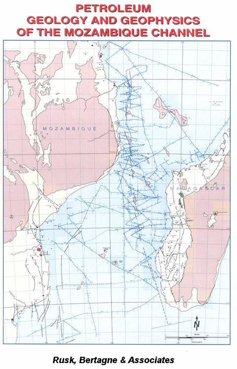
2 PETROLEUM GEOLOGY AND GEOPHYSICS OF THE MOZAMBIQUE CHANNEL ANNOUNCEMENT Rusk, Bertagne & Associates are pleased to announce the completion of a three year study and the publication of a report entitled "The Petroleum Geology and Geophysics of the Mozambique Channel". The study includes the coastal and offshore sectors of Mozambique, southern Tanzania, northern and western Madagascar and the Comoros Islands. It covers an area of approximately 1.3 million sq.km., representing one third of offshore East Africa and equivalent to 1 and 1/2 times the size of the North Sea. This vast frontier incorporates nine basins, with sedimentary sections ranging from 6,000 meters to 11,000 meters in thickness. On the periphery, oil and gas have been discovered: two offshore gas fields in southern Tanzania have combined reserves exceeding 2Tcf; the Mozambique Pande-Temane complex, with gas now being delivered by pipeline to South Africa, has approximately 3,5 Tcf of reserves; and in Madagascar the Bemolanga tar sands have reserves estimated at 21 billion barrels while the Tsimiroro oilfield has an estimated 8 billion barrels of heavy oil-in-place. In spite of the regional expanse, favorable geology and petroleum occurrences, to date only 23 offshore exploration wells have been drilled in the area of study. This lack of activity in the past was mostly due to water depth which averages roughly 2000 meters over the area. The basis of the study has been our exclusive use of 31,000 km of deep-water seismic data. These data, which are the property of some of the Host governments and three French universities and associated research groups, have not been used previously for detailed petroleum exploration studies. This data set has been integrated with 2000 km of shallow-water seismic and data from all pertinent onshore and offshore wells throughout the region. Additionally, in 2001, Rusk, Bertagne & Associates acquired 2000 km of 98 fold CDP data strategically positioned to verify new geological concepts revealed by the study. In addition to establishing the stratigraphy and structure configuration of each of the nine basins we have identified an abundance of structural leads, some salt related, with dimensions analogous to giant fields. Also, based on well data analyses, effective oil and gas prone source beds of Permo-Triassic, Jurassic and Cretaceous ages are represented in seven of the nine subject basins. Finally, of particular importance in regard to area or basin comparison and focus, offshore basin evaluation summaries have been prepared and include a concise compilation of petroleum related elements with risk analyses.
3 EXECUTIVE SUMMARY 1) 2) 3) 4) 5) Large frontier area 1 and 1/2 times the size of the North Sea comprising 9 sedimentary basins with limited exploration on the shelf areas only. The basins display varied structural styles, a thick sedimentary section (over 10 km or 33,000 ft) the presence of evaporites, and appear to be mostly oil-prone. Multi petroleum systems combined with mega-anticlinal structures. Several prospects with shallow drill depth (2000 mts) and in technologically manageable water depths (1300 to 1600 mts) have been conclusively established. Sea bottom samples and core holes indicate that the Davie Fracture Zone is not of volcanic origin but a more recent wrench fault zone similar to the San Andreas fault oil province of California. Period of expulsion and migration of hydrocarbons synchronous with the growth of the anticlinal structures. Near-by presence of large fossil oilfields in Madagascar (Bemolanga 21 billion barrels of reserves; Tsimiroro 8 billion barrels of reserves) and gas in Mozambique (Pande-Temane gas field: 3 Tcf recoverable; now being developed commercially with gas being piped to South Africa). 6A) Comprehensive geological/geophysical report (text plus 70 enclosures in electronic format) based on 31,000 Km of single and multi-channel 2D seismic (including 2200 Km of strategically positioned 98 fold CDP coverage acquired in 2001) tied to existing well control. Until recently, most of these data were not available for petroleum exploration purposes. 6B) Additional report (available separately) providing data on sea bottom samples and shallow core information establishing the sedimentary nature of the Davie Fracture Zone, and including detailed maps and montages of all the major mega-prospects and leads which are considered as drillable with minor additional seismic work. 6 to 8 strategically positioned well locations should determine at an early stage whether the area will become a major oil province. 7) 8) Welcoming governments with attractive PSC terms and the proximity to the traditional tanker routes to Europe and the Far East. Large amount of open acreage. Excellent marine facilities at Diego Suarez, Madagascar, as supply base, manufacturing and repairs, and Narinda Bay for platform assembly and/or construction.
4 9) The Mozambique Channel is comparable to the North Sea in the mid-sixties when the discovery of a large gas field to the south (Groningen) attracted the attention to an area which is now established as a major petroleum producing province. 10) In conclusion, the area provides an opportunity for a major acreage play offering the possible discovery of large reserves on a short term basis, which could have a strong impact on the growth of a mega-independent or a major.
5 INTRODUCTION The study area, which includes the Mozambique Channel with water depths from 500 to 4000 meters, and the bordering coastal shelves of Madagascar, Mozambique, and southern Tanzania is approximately 1,300,000 sq. kms, an area greater than the North Sea (Figs. 1& 2). This vast area of study comprises 9 basins or sub-basins, each with a unique set of hydrocarbon factors. Although major gas reserves (3.5 TCF) of the Pande-Temane complex in Mozambique, and the Bemolanga tar sands (20 billion barrels) and Tsimiroro oilfield (8 billion barrels) in Madagascar have been known for years, a total of only 23 exploration wells have been drilled offshore. DATABASE Approximately 31,000 kms of seismic profiles have been interpreted and integrated with well, gravity, and magnetic data (Fig. 2). The seismic data, which were not available until now, are 1972 to 1989 vintage, multi-channel recordings with Flexotir source. These data can be integrated with the existing seismic control acquired by oil companies on the Mozambique shelf (50,000 kms) and on the Madagascar shelf (40,000 kms). Seismic refraction data, recorded in tandem with reflection data along several profiles provides additional control. Geologic data from approximately 80 onshore and 23 offshore wells in Mozambique, Madagascar and southern Tanzania has been utilized in the interpretation and evaluation process. Research and other archival geologic and geophysical studies provided by OMNIS, ENH, IPCP, EOST, CNRS and Geoscience Azur have been utilized for the project. GEOLOGIC SETTING From late Carboniferous to late Triassic - early Jurassic, East Africa was deformed by recurrent rifting, which resulted in Karoo continental deposition. During a post-karoo early Jurassic transgression, clastic, carbonates and evaporites were deposited along the pre-breakup plate margins. A subsequent marine transgression took place in mid Jurassic with widespread deposition of shelf carbonates and basinal sediments. At this stage, probably Bajocian, the onset of drift occurred. The Madagascar - India - Antarctica plate separated from Africa, moving incrementally southward along the Davie Fracture Zone until early Aptian (Fig. 3). During the drift phase, predominantly marine deposition took place throughout the region. The post-drift marginal sag phase, which followed an Aptian hiatus and persisted until the present, resulted in the deposition of thick marine siliciclastics.
6
7
8
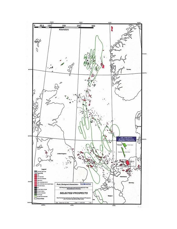
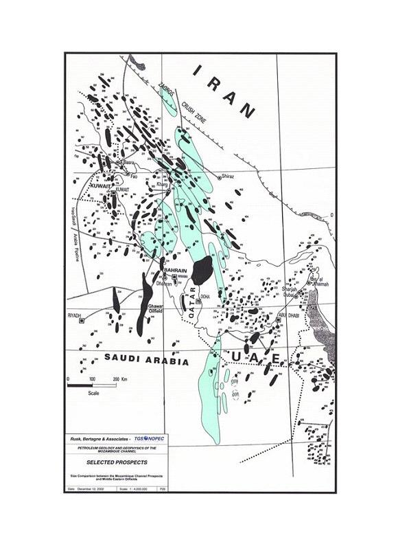
9 HYDROCARBON SYSTEMS AND PLAYS Stratigraphy Numerous sandstone and, to a lesser degree, carbonate quality reservoir objectives have been penetrated in wells along the shelf and coastal areas. In consideration of the thick sedimentary section further offshore, equally potential reservoir sequences are expected (Fig. 4). Source Rock Permo- Triassic lacustrine shale, the established source for the Bemolanga Tar Sand deposit, can be expected in any of the offshore sectors underlain by continental crust (Fig. 5). Lower Jurassic rich, oil-prone shale has been identified in two basins and most likely is present in others. Also, geochemical results from well data indicate extensive occurrence of oil and gas-prone source beds of Middle Jurassic to Upper Cretaceous age. Throughout the study area, there is evidence for a consistent increase of argillaceous facies and organic matter basinward, as would be expected. This evidence coupled with the likelihood that faulting associated with the Davie Fracture Zone formed barriers to circulation, suggests that deposits with oil-prone kerogen may be prevalent within the Jurassic - Cretaceous section. Trap Types A wealth of trap types of potentially major dimensions have been identified, including salt structures, tilted fault blocks, horsts, drape anticlines and flower structures (Fig. 6 & 7). The combination of multiple reservoirs and source rocks and the seismic evidence for numerous structural leads suggests the presence of a wide variety of plays with major resource potential. PROSPECTS Several maps have been generated of the Mozambique Channel anticlinal prospects superimposed on major oil provinces around the world. As an example of our findings, the following figures (8, 9, and 10) illustrate these prospects superimposed on the North Sea and Middle-East oilfields for size comparison.
10

11
12
13

14
15
16 REPORT - TABLE OF CONTENTS Introduction Previous Exploration Exploration Drilling Seismic Surveys Oil And Gas Fields Tectonic History General Karoo Rift Phase - Late Carboniferous To Early Jurassic Post-Rift Transition Phase - Early Jurassic Initial Drift Phase - Bajocian To Aptian Passive Margin Subsidence And Second Drift Phase - Albian To Maestrichtian Passive Margin Subsidence - Tertiary Stratigraphy and Sedimentation Carboniferous To Early Jurassic - Karoo Early Jurassic To Early Cretaceous Volcanics - Karoo To Post-Karoo Early Jurassic - Post-Karoo Middle Jurassic Late Jurassic Early Cretaceous Late Cretaceous Tertiary Petroleum Elements General Source Rocks Permo-Triassic Early Jurassic Middle Jurassic Late Jurassic Early Cretaceous Late Cretaceous Maturity, Migration, Timing And Preservation Permo-Triassic And Early Jurassic Middle Jurassic Early And Late Cretaceous Reservoirs General Permo-Triassic And Early Jurassic Middle Jurassic
17 Late Jurassic Early Cretaceous Late Cretaceous Trap Types, Seismic Leads And Prospects Seals Conclusions REPORT - FIGURES Tables Oil and Gas Discoveries Karoo and Post-Karoo Bolcanics in Southern Mozambique Appendices I. Basin Evaluation Summaries: Central Davie Fracture Zone and Cap St. Andre sub-basin Comoros basin Limpopo embayment Majunga basin Morondava basin Mozambique Coastal basin Mozambique Channel basin Rovuma basin and north Davie Fracture Zone Zambezi Delta basin II. Well Formation And Age Tops III. Source Rock Data IV. Seismic Surveys And Velocity Data Enclosures Base Map Regional Geologic Map Bouguer Gravity Map - Offshore and Onshore Seismic Survey Map Chrono-stratigraphic - Tectonic Chart Regional Tectonic Elements Map East Africa - Madagascar Paleogeographic Evolution & Plate Reconstruction Panel 1:3,000,000
18 Index Map - Geo-Seismic Cross Sections, Correlations and Seismic Transects Geo-Seismic Cross Sections, A-A' Rovuma Basin - Davie Fracture Zone (DFZ) Geo-Seismic Cross Sections, B-B' Rovuma Basin - DFZ Geo-Seismic Cross Sections, C-C' Lacerda Graben - DFZ Geo-Seismic Cross Sections, D-D' Majunga Basin Geo-Seismic Cross Sections, E-E' Morandava Basin - DFZ Geo-Seismic Cross Sections, F-F' Morandava Basin - DFZ Geo-Seismic Cross Sections, G-G' Zambezi Delta Basin Geo-Seismic Cross Sections, H-H' Mozambique Coastal Basin - Beira High Geo-Seismic Cross Sections, I-I' Limpopo Embayment Well-Seismic Stratigraphic Correlations, J-J' to M-M' (4) Regional Seismic Transects (10) Generalized Total Sediment Isopach Map Isopach Map - Karoo Isopach Map - Post Karoo Isopach Map - Top Lower Cretaceous to Top Karoo Isopach Map - Upper Cretaceous Isopach Map - Tertiary Isopach Map, North - Upper Cretaceous Isopach Map, Southwest - Upper Cretaceous Isopach Map, Southeast - Upper Cretaceous Isopach Map, North - Tertiary Isopach Map, Southwest - Tertiary Isopach Map, Southeast - Tertiary Isopach-Facies Map - Lower Jurassic Isopach-Facies Map - Middle Jurassic Isopach-Facies Map - Upper Jurassic Isopach-Facies Map - Lower Cretaceous Isopach Map, Mozambique Coastal- Zambezi Delta Basin - Domo Formation Isopach Map, Mozambique Coastal- Zambezi Delta Basin - Grudja Formation 1:1,000,000 1:1,000,000 1:1,000,000 1:1,000,000 1:1,000,000 1:1,000,000 1:1,000,000 1:1,000,000 Regional Structure Map - Top Karoo (Seafloor to Top Karoo)
19 Regional Structure Map - Top Lower Jurassic (Seafloor'to Top Lower Jurassic) Regional Structure Map - Top Middle Jurassic (Seafloor to Top Middle Jurassic) Regional Structure Map - Top Upper Jurassic (Seafloor to Top Upper Jurassic) Regional Structure Map - Top Lower Cretaceous (Seafloor to Top Lower Cretaceous) Regional Structure Map - Top Upper Cretaceous (Seafloor to Top Upper Cretaceous) Seismic Time Structure Map, Top Karoo Seismic Time Structure Map, Top Upper Cretaceous Volcanics Seismic Isochron Map, Top Upper Cretaceous Volcanics to Quaternary Seismic Isochron Map, Top Karoo to Upper Cretaceous Volanics Regional Geothermal Gradient Map Potential Oil-Prone Source Rock DistributioJ;l & Maturity, Panel I Karoo & Lower Jurassic Potential Oil-Prone Source Rock Distribution & Maturity, Panel II Middle Jurassic & Upper Jurassic Potential Oil-Prone Source Rock Distribution & Maturity, Panel III Lower Cretaceous & Upper Cretaceous Potential Reservoir Distribution, Permo-Triassic - Lower Jurassic 1:3,000,000 1:3,000,000 1:3,000,000 1:3,000,000 1:3,000,000 Potential Reservoir Distribution, Panel I - Middle Jurassic & 1:3,000,000 Upper Jurassic Potential Reservoir Distribution, Panel II - Lower Cretaceous 1:3,000,000 & Upper Cretaceous Prospects and Leads, Index Map Prospects and Leads - Panel I Rovuma Basin - North Davie Fracture Zone and Central Davie Fracture Zone Prospects and Leads - Panel II Morondava Basin and Majunga Basin Prospects and Leads - Panel III Zambezi Delta Basin
20 REPORT - FORMATS The license fee will include a digital copy of all70 maps and a.pdf of the text. All the maps will be in Illustrator format, except for the 8 listed below, which will be in ArcGIS 8.1. Maps in ArcGIS 8.1 format: 1. Potential Oil-Prone Source Rock Distribution & Maturity, Karoo & Lower Jurassic- Panel I 2. Potential Oil-Prone Source Rock Distribution & Maturity, Middle Jurassic & Upper Jurassic - Panel ll 3. Potential Oil-Prone Source Rock Distribution & Maturity, Lower Cretaceous & Upper Cretaceous- Panel III 4. Potential Reservoir Distribution, Permo - Triassic - Lower Jurassic 5. Potential Reservoir Distribution, Middle Jurassic & Upper Jurassic-Panel I 6. Potential Reservoir distribution, Lower Cretaceous & Upper Cretaceous - Panel ll 7. Regional Geothermal Gradient Map 8. Regional Geologic Map Paper copies and additional digital copies of the maps and the report are available at reproduction costs.
21 PRINCIPAL GEOSCIENTISTS All technical information can be provided by the following Geoscientists Donald C. Rusk, Geologist Previous experience with AMOCO (30 years), and as an international petroleum exploration consultant (10 years). Member Emeritus of the AAPG, SEG, HGS, GSH and EAGS. Has recently produced in-depth regional reports on Libya, Algeria, Syria, and Ecuador. Has experience in over 150 sedimentary basins in 70 countries including 8 years of exploration work on Madagascar, Tanzania and Mozambique with AMOCO. (tel: ; dcrusk@comcast.net) Robert G. Bertagne, Geophysicist Previous experience with CONOCO (20 years) and as an international petroleum exploration consultant (24 years) for majors, independents, and the WORLD BANK, various Host Countries and the United States Government (US AID). Member Emeritus of the AAPG, SEG, HGS, and GSH. Has experience in 77 sedimentary basins located in 44 countries which includes six years of exploration and operations experience in Madagascar and East Africa with CONOCO. (tel: ; rbertagne@petromarex.com) Business Contacts Donald C. Rusk Geologist Director Robert G. Bertagne Geophysicist Director Ph: [1] (281) Fax: [1] (281) dcrusk@comcast.net Ph: [1] (281) Fax: [1] (281) rbertagne@comcast.net
MUHAMMAD S TAMANNAI, DOUGLAS WINSTONE, IAN DEIGHTON & PETER CONN, TGS Nopec Geological Products and Services, London, United Kingdom
 Geological and Geophysical Evaluation of Offshore Morondava Frontier Basin based on Satellite Gravity, Well and regional 2D Seismic Data Interpretation MUHAMMAD S TAMANNAI, DOUGLAS WINSTONE, IAN DEIGHTON
Controls on clastic systems in the Angoche basin, Mozambique: tectonics, contourites and petroleum systems
 P2-2-13 Controls on clastic systems in the Angoche basin, Mozambique: tectonics, contourites and petroleum systems Eva Hollebeek, Olivia Osicki, Duplo Kornpihl Schlumberger, London, UK Introduction Offshore
Debra K. Gomez 1 and David Brewster 2. Search and Discovery Article #10843 (2016)** Posted March 21, Abstract
** Posted March 21, Abstract") PS Petroleum Potential Onshore Southern Madagascar, Morandava Basin, Block 3114* Debra K. Gomez 1 and David Brewster 2 Search and Discovery Article #10843 (2016)** Posted March 21, 2016 *Adapted from poster
PS Petroleum Potential Onshore Southern Madagascar, Morandava Basin, Block 3114* Debra K. Gomez 1 and David Brewster 2 Search and Discovery Article #10843 (2016)** Posted March 21, 2016 *Adapted from poster
Petroleum potential of the Morondava Basin Madagascar Promotional Meeting.
 Petroleum potential of the Morondava Basin Madagascar Promotional Meeting. Houston, May 25 th 2006 Chris Matchette-Downes adapted from Graham Hyden s London presentation 23 rd May TGS-NOPEC Geophysical
: Morondava Basin, Offshore Madagascar New Long Offset Seismic Data highlights the Petroleum Prospectivity of this Emerging Frontier Basin.
 1555684: Morondava Basin, Offshore Madagascar New Long Offset Seismic Data highlights the Petroleum Prospectivity of this Emerging Frontier Basin. Glyn Roberts(1); Trond Christoffersen(2); Huang Weining(3).
East Africa Transform Margin The View from Tanzania and Madagascar
 East Africa Transform Margin The View from Tanzania and Madagascar Richard Higgins and Mark Sofield 10 th PESGB/HGS Conference on African E & P, London, September 7-8, 2011 Acknowledgements Legal Notice:
A comparison of structural styles and prospectivity along the Atlantic margin from Senegal to Benin. Peter Conn*, Ian Deighton* & Dario Chisari*
 A comparison of structural styles and prospectivity along the Atlantic margin from Senegal to Benin Overview Peter Conn*, Ian Deighton* & Dario Chisari* * TGS, Millbank House, Surbiton, UK, KT6 6AP The
TH P5 07 INSIGHTS INTO THE TECTONIC EVOLUTION AND PROSPECTIVITY OF MADAGASCAR OFFSHORE BASINSN
 Technical paper TH P5 07 INSIGHTS INTO THE TECTONIC EVOLUTION AND PROSPECTIVITY OF MADAGASCAR OFFSHORE BASINSN Authors R. Dirkx* (TGS), F. Winter (TGS), S. Musa (TGS), R. Cooke (TGS), B. Sayers (TGS),
Perspectives from Offshore Argentina & Uruguay
 Perspectives from Offshore Argentina & Uruguay A Prospectivity Overview Hannah Kearns October 2018 Introduction Argentina Offshore License Round 1 14 blocks Argentina North, 24 Austral-Malvinas Offshore
KENYA ONSHORE, LAMU BASIN Block L14 FARM- IN OPPORTUNITY
 KENYA ONSHORE, LAMU BASIN Block L14 FARM- IN OPPORTUNITY Lamu Oil and Gas, a joint venture between QFB and Edgo Energy, is seeking one or more partners, to continue exploration of their highly attractive
Petroleum Prospectivity in the Namibe and Southern Benguela Basins, Offshore Angola
 Petroleum Prospectivity in the Namibe and Southern Benguela Basins, Offshore Angola C. Koch* (PGS), F. Pepe (PGS), R. Vasconcelos (PGS), F. Mathew (PGS), R. Borsato (PGS) & M.P.C. de Sá (Sonangol) SUMMARY
Petroleum geology framework, West Coast offshore region
 Petroleum geology framework, West Coast offshore region James W. Haggart* Geological Survey of Canada, Vancouver, BC jhaggart@nrcan.gc.ca James R. Dietrich Geological Survey of Canada, Calgary, AB and
Overview of Mozambique Digital Atlas MOZDA. MOZDA 2014 Release
 Overview of Mozambique Digital Atlas MOZDA MOZDA 2014 Release MOZDA 2014 - Mozambique Digital Atlas A regional framework of Mozambique Wells, Headers, Formation Tops, Seismic Stratigraphic Framework Key
Figure 1: Location and bathymetry of the study area. Gulf of Guinea. Cameroon. Congo. Gabon. PGS/DGH Gabon MegaSurvey Coverage (35000Km 2 ) Eq.
 Eq.") Deepwater hydrocarbon prospectivity analysis of offshore North and South Gabon Muhammad S Tamannai (*), Thomas Hansen (1), Ron Borsato (1), Jennifer Greenhalgh (1) Martial-Rufin Moussavou (2) & Landry
Deepwater hydrocarbon prospectivity analysis of offshore North and South Gabon Muhammad S Tamannai (*), Thomas Hansen (1), Ron Borsato (1), Jennifer Greenhalgh (1) Martial-Rufin Moussavou (2) & Landry
APPENDIX C GEOLOGICAL CHANCE OF SUCCESS RYDER SCOTT COMPANY PETROLEUM CONSULTANTS
 APPENDIX C GEOLOGICAL CHANCE OF SUCCESS Page 2 The Geological Chance of Success is intended to evaluate the probability that a functioning petroleum system is in place for each prospective reservoir. The
Israel: Seeing Deeper Imaging new play concepts with Clari-Fi broadband reprocessing
 Israel: Seeing Deeper Imaging new play concepts with Clari-Fi broadband reprocessing Alex Birch-Hawkins Interpretation Geophysicist 12 th December 2016 Contents TGS in Israel Geological Overview Exploration
Meandering Miocene Deep Sea Channel Systems Offshore Congo, West Africa
 Meandering Miocene Deep Sea Channel Systems Offshore Congo, West Africa S. Baer* (PGS), J. E. Comstock (PGS), K. Vrålstad (PGS), R. Borsato (PGS), M. Martin (PGS), J.P. Saba (SNPC), B. Débi-Obambé (SNPC)
Orphan Basin, Offshore Newfoundland: New seismic data and hydrocarbon plays for a dormant Frontier Basin
 Orphan Basin, Offshore Newfoundland: New seismic data and hydrocarbon plays for a dormant Frontier Basin Jerry Smee* G&G Exploration Consulting, 301 400-3rd Avenue SW, Calgary, AB, T2P 4H2 Sam Nader, Paul
EGAS. Ministry of Petroleum
 EGAS Ministry of Petroleum EGAS Ministry of Petroleum About The Block Location: N. Thekah offshore block is located at about 56 km to the north of the Mediterranean shore line, 85 km to the north west
AAPG European Region Annual Conference Paris-Malmaison, France November RESOURCES PERSPECTIVES of the SOUTHERN PERMIAN BASIN AREA
 AAPG European Region Annual Conference Paris-Malmaison, France 23-24 November 2009 RESOURCES PERSPECTIVES of the SOUTHERN PERMIAN BASIN AREA J.C. DOORNENBAL, TNO Built, Environment and Geosciences, Geological
RWE Dea UK SNS Limited (50%), Faroe Petroleum (UK) Limited
, Faroe Petroleum (UK) Limited") 1. Licence information Licence Number P1975 Licence Round 27 th (2012) Licence Type Traditional Blocks 3/28c & 9/3e Licensees Work Programme 2. Synopsis RWE Dea UK SNS Limited (50%), Faroe Petroleum (UK)
1. Licence information Licence Number P1975 Licence Round 27 th (2012) Licence Type Traditional Blocks 3/28c & 9/3e Licensees Work Programme 2. Synopsis RWE Dea UK SNS Limited (50%), Faroe Petroleum (UK)
RELINQUISHMENT REPORT. License P1546 Block April 2009
 RELINQUISHMENT REPORT License P1546 Block 110-01 14 April 2009 Sherritt International Oil and Gas Limited 2000, 425-1 st street S.W., Calgary, Alberta Canada T2P 3L8 Telephone (403) 260-2900 Fax (403)
For personal use only
 ASX ANNOUNCEMENT 11 September 2018 Billion Barrel Oil Potential Assessed in Pancontinental s PEL 87 Offshore Namibia Giant* scale oil potential in multiple Large Leads in PEL 87 Vast Cretaceous Superfan
Extended Abstract for presentation at EAGE Meeting Paris 13/ History of Norwegian Petroleum Exploration and its impact on Norwegian Geosciences
 Extended Abstract for presentation at EAGE Meeting Paris 13/6 2017 History of Norwegian Petroleum Exploration and its impact on Norwegian Geosciences Knut Bjørlykke University of Oslo Abstract Before petroleum
Building for the Future with Global Knowledge and Dedicated Skills. Jan Maier North Africa Capital Markets Day
 Building for the Future with Global Knowledge and Dedicated Skills Jan Maier North Africa 1 Core Plays: Recent and Current Exploration in North Africa Sirte Basin Matruh Basin CORE PLAYS Fold Belts Rift
Overview of Selected Shale Plays in New Mexico*
 Overview of Selected Shale Plays in New Mexico* Ron Broadhead 1 Search and Discovery Article #10627 (2014)** Posted August 18, 2014 *Adapted from presentation at RMAG luncheon meeting, Denver, Colorado,
EGAS. Ministry of Petroleum
 EGAS Ministry of Petroleum EGAS Ministry of Petroleum About The Block Location: N. El Arish offshore block is located in the extreme eastern part of the Egypt s economic water border and bounded from the
Blocks offered in Sri Lanka s Second Licensing Round
 Blocks offered in Sri Lanka s Second Licensing Round Sri Lankan Main Basins Cauvery Basin Cauvery Deep Water sub-basin Mannar Basin 2 Structural Framework Sri Lanka Basins Cauvery & Mannar Basins were
B.C. s Offshore Oil and Gas: a Guide to the Geology and Resources.
 B.C. s Offshore Oil and Gas: a Guide to the Geology and Resources. Introduction Beneath the offshore regions of British Columbia are four moderately large, geologically young sedimentary basins (Figure
BALOCHISTAN FOLDBELT BASIN
 INTRODUCTION BALOCHISTAN FOLDBELT BASIN The Kharan-3 block is located in the Kharan Trough of Balochistan Basin. GEOLOGICAL SETTING The Balochistan Province is an Upper Cretaceous to Recent structurally
Ministry of Oil and Minerals Petroleum Exploration & Production Authority BLOCK 85 (Al Uqlah North)
") Ministry of Oil and Minerals Petroleum Exploration & Production Authority BLOCK 85 (Al Uqlah North) The Al Uqlah North Block (85) occupies an area of 597 km 2 in the Sabatayn Basin in the province of Shabwah
Ministry of Oil and Minerals Petroleum Exploration & Production Authority BLOCK 85 (Al Uqlah North) The Al Uqlah North Block (85) occupies an area of 597 km 2 in the Sabatayn Basin in the province of Shabwah
Deepwater Hydrocarbon Potentialof Orange Basin, South Africa: An Untested Oil Play
 Deepwater Hydrocarbon Potentialof Orange Basin, South Africa: An Untested Oil Play Soumen Dasgupta*, Moumita Sengupta, Prem Kumar, Biswanath Ghosh, Dr. BNS Naidu anddr. Sudhir Mathur. Cairn India Limited,
Exploration, Drilling & Production
 Nontechnical Guide to PETMOLEUM Geology, Exploration, Drilling & Production Third Edition Norman J. Hyne, Ph.D. Contents Preface *i Introduction 1 The Nature of Gas and Oil 1 Petroleum 1 The Chemistry
Ministry of Oil and Minerals Petroleum Exploration & Production Authority BLOCK 80 (WADI SARR)
") Ministry of Oil and Minerals Petroleum Exploration & Production Authority BLOCK 80 (WADI SARR) The Wadi Sarr Block (80) occupies an area of 1961 km 2 on the Sayun- Masilah Basin in the central Yemen. Block
Ministry of Oil and Minerals Petroleum Exploration & Production Authority BLOCK 80 (WADI SARR) The Wadi Sarr Block (80) occupies an area of 1961 km 2 on the Sayun- Masilah Basin in the central Yemen. Block
ONSHORE / OFFSHORE & NEW SHALE POTENTIAL OF MOROCCO
 Kingdom of Morocco ONSHORE / OFFSHORE & NEW SHALE POTENTIAL OF MOROCCO Mr M. NAHIM Mrs N. ESSALLOUMI Key aspects of Morocco Political and economic stability; Economic policy of integration at regional
Kilometre-Scale Uplift of the Early Cretaceous Rift Section, Camamu Basin, Offshore North-East Brazil*
 Kilometre-Scale Uplift of the Early Cretaceous Rift Section, Camamu Basin, Offshore North-East Brazil* Iain Scotchman 1 and Dario Chiossi 2 Search and Discovery Article #50183 (2009) Posted May 20, 2009
Ministry of Oil and Minerals Petroleum Exploration & Production Authority BLOCK 6 (Iryam)
") Ministry of Oil and Minerals Petroleum Exploration & Production Authority BLOCK 6 (Iryam) The Iryam Block (6) occupies an area of 3,911 km 2 in the Sabatayn Basin in the province of Shabwah in central
Ministry of Oil and Minerals Petroleum Exploration & Production Authority BLOCK 6 (Iryam) The Iryam Block (6) occupies an area of 3,911 km 2 in the Sabatayn Basin in the province of Shabwah in central
Aptian/Albian Reservoir Development in the Jeanne d Arc Basin, Offshore Eastern Canada
 Aptian/Albian Reservoir Development in the Jeanne d Arc Basin, Offshore Eastern Canada Jonathan Marshall, Statoil Canada Ltd. Calgary, Alberta, Canada. jomars@statoil.com Introduction: The Jeanne d Arc
Hydrocarbon Potential of the Marginal Fields in Niger Delta Oza Field, a case study*
 Hydrocarbon Potential of the Marginal Fields in Niger Delta Oza Field, a case study* J.N. Sahu 1, C.H.V. Satya Sai 1, V. Chintamani 1 and C. Vishnu Vardhan 1 Search and Discovery Article #20182 (2012)*
Blocks 31, 32, 33, 34, 35 & 36/03 Southeast Offshore Vietnam
 Blocks 31, 32, 33, 34, 35 & 36/03 Southeast Offshore Vietnam Block 31 32 33 34 35 36/03 Area (km 2) 5,036 4,440 4,630 4,700 4,630 2,950 Sea level (m) 20 20-30 30-40 50 50 50 Seismic 2D (km) 1,294 685 431
Hydrocarbon plays of the Mid North Sea High: an integrated seismic and basin modelling study
 Hydrocarbon plays of the Mid North Sea High: an integrated seismic and basin modelling study Stephen Corfield, Julian Moore, Maurice Bamford, Andrew Barnwell and Patrick Barnard -OGA Frontier exploration
Sedimentary Cycle Best Practice: Potential Eo-Oligocene Sediments in Western Indonesia*
 Sedimentary Cycle Best Practice: Potential Eo-Oligocene Sediments in Western Indonesia* Mellinda Arisandy 1 and I Wayan Darma 1 Search and Discovery Article #11008 (2017)** Posted November 6, 2017 *Adapted
RELINQUISHMENT REPORT. UK Traditional Licence P Blocks 12/16b & 12/17b. First Oil Expro Limited (Operator, 46.67%)
") RELINQUISHMENT REPORT UK Traditional Licence P.1887 Blocks 12/16b & 12/17b First Oil Expro Limited (Operator, 46.67%) Nautical Petroleum Limited (26.67%) North Sea Energy (UK NO2) Limited (26.67%) February
RELINQUISHMENT REPORT UK Traditional Licence P.1887 Blocks 12/16b & 12/17b First Oil Expro Limited (Operator, 46.67%) Nautical Petroleum Limited (26.67%) North Sea Energy (UK NO2) Limited (26.67%) February
SouthWest Energy (HK) Ltd.
 Ltd.") SouthWest Energy (HK) Ltd. Investor Presentation Cape Town October 2012 Why Are We Searching Oil in SWE Blocks? Similar geological g setting with Yemen s producing fields Oil seeps and oil show in the
SouthWest Energy (HK) Ltd. Investor Presentation Cape Town October 2012 Why Are We Searching Oil in SWE Blocks? Similar geological g setting with Yemen s producing fields Oil seeps and oil show in the
PETROLEUM GEOSCIENCES GEOLOGY OR GEOPHYSICS MAJOR
 PETROLEUM GEOSCIENCES GEOLOGY OR GEOPHYSICS MAJOR APPLIED GRADUATE STUDIES Geology Geophysics GEO1 Introduction to the petroleum geosciences GEO2 Seismic methods GEO3 Multi-scale geological analysis GEO4
Prospectivity of the Equatorial Conjugate Margins of Africa and South America
 Prospectivity of the Equatorial Conjugate Margins of Africa and South America Ron Borsato* 1, Jennifer Greenhalgh 1, Steve Wells 1, Rick Roberson 1, Carlos Fontes 2 1 PGS, 2 Geohub Contents Introduction
Luderitz Basin, Offshore Namibia: Farm-out Opportunity. APPEX, London, March 2015 Graham Pritchard, Serica Energy plc
 Luderitz Basin, Offshore Namibia: Farm-out Opportunity APPEX, London, March 2015 Graham Pritchard, Serica Energy plc Serica Luderitz Basin Namibia Introduction Serica (85%, operator) 17,384 km 2 acreage
REGIONAL GEOLOGY IN KHMER BASIN
 CONTENTS 1-Khmere Basin 2-Regional Geology Khmer Basin 3-Regime Tectonic 4-Seismic Database -a/ Acquisition Data -b/ Prospect Angkor -C/ Cross Section Seismic 5-Play Type -a/ Play Schematic -b/ Structure
Bulletin of Earth Sciences of Thailand. Evaluation of the Petroleum Systems in the Lanta-Similan Area, Northern Pattani Basin, Gulf of Thailand
 Evaluation of the Petroleum Systems in the Lanta-Similan Area, Northern Pattani Basin, Gulf of Thailand Sirajum Munira Petroleum Geoscience Program, Department of Geology, Faculty of Science, Chulalongkorn
Exploration Opportunities in the Middle East
 Exploration Opportunities in the Middle East Richard Herbert R Herbert Associates Ltd Finding Petroleum Middle East Forum Tuesday 16 th May 2017 The Geological Society, London Agenda What defines the Middle
Page 1 of 6 Target Exploration Consultants Ltd. is a United Kingdom registered company no
 26-27 November 2018 at Al-Nawras Hotel, Dubai, UAE Instructor: Dr. Mohammed Warrak, PhD. Target Exploration Consultants, London, UK. www.targetexploration.com Page 1 of 6 Target Exploration Consultants
Outline 16: The Mesozoic World: Formation of Oil Deposits (with a side trip to the Devonian Marcellus Shale)
") Outline 16: The Mesozoic World: Formation of Oil Deposits (with a side trip to the Devonian Marcellus Shale) The first commercial oil well was drilled by Colonel Edwin Drake in Titusville, Pennsylvania,
Outline 16: The Mesozoic World: Formation of Oil Deposits (with a side trip to the Devonian Marcellus Shale) The first commercial oil well was drilled by Colonel Edwin Drake in Titusville, Pennsylvania,
Breaking Paradigms Giant and Super-Giant discoveries in Brazil
 Michel T. Halbouty Lecture Breaking Paradigms Giant and Super-Giant discoveries in Brazil G. Estrella Petrobras Director E&P Copyright AAPG. Serial rights given by author. For all other rights contact
New Portfolio Asset - Namibia
 Market Announcements Platform ASX Limited Exchange Centre 20 Bridge Street Sydney NSW 2000 ASX Code: CE1 10/05/2018 New Portfolio Asset - Namibia Highlights: Calima has been awarded a 56% interest and
Hydrocarbon Exploration in Morocco: Status & Perspectives
 Hydrocarbon Exploration in Morocco: Status & Perspectives Outline Conventional HC Exploration; Licensing Status; Exploration ancient objectives and New ones Perspectives; Objectives of the Remaining open
Côte d I d Ivoire: Undiscovered Opportunities and voire: New Undiscovered Data in Open Opportunities Blocks and New Data in Open Blocks
 Côte d I d Ivoire: Undiscovered Opportunities and voire: New Undiscovered Data in Open Opportunities Blocks and New Data in Open Blocks Christine Roche, Project Geoscientist; PGS Christine Roche, Project
BACK TO BASICS WHY THE TORRES BASIN COULD BE A COMPANY MAKER Papua New Guinea :PPL326 A Frontier Basin
 BACK TO BASICS WHY THE TORRES BASIN COULD BE A COMPANY MAKER Papua New Guinea :PPL326 A Frontier Basin 1 Tertiary Carbonate/Clastic Prospects and Leads PNG_LNG Facility PPL326 has a large number of over
1. Canadian Energy Use
 1 Unit 3 Energy 2 1. Canadian Energy Use Why are Canadians the sixth highest energy users in the world? Our major industries are energy intensive, overall industry consumes 31% of all energy in Canada.
Hydrocarbon Exploration in Morocco: Current Activities and Opportunities. H. Jabour
 Hydrocarbon Exploration in Morocco: Current Activities and Opportunities H. Jabour O N H Y M February 06, 2013 Outline Background Hydrocarbon potential of Morocco Non-Conventional Hydrocarbon Resources
HORDA SURVEY HERALDS NEW STRATEGY
 HORDA SURVEY HERALDS NEW STRATEGY CGG sets sights on multi-client market leadership in Norway BY IDAR HORSTAD, ERLING FRANTZEN AND JO FIRTH, CGG 12 seismic profile Figure 1: Reprocessing of the Cornerstone
DEEP WATER WEST COAST INDIA THE OPENING OF A NEW PLAY BENEATH THE DECCAN BASALTS
 DEEP WATER WEST COAST INDIA THE OPENING OF A NEW PLAY BENEATH THE DECCAN BASALTS Glyn Roberts 1, Charles Harmer 2, Ken Rutherford 3, Colin O Brien 4 1 Consultant, UK; 2 Spectrum Geo, UK; 3 Rutherford Exploration
Case Study of the Structural and Depositional-Evolution Interpretation from Seismic Data*
 Case Study of the Structural and Depositional-Evolution Interpretation from Seismic Data* Yun Ling 1, Xiangyu Guo 1, Jixiang Lin 1, and Desheng Sun 1 Search and Discovery Article #20143 (2012) Posted April
For personal use only
 12 October 2012 Companies Announcement Office Australian Securities Exchange Limited 10th Floor, 20 Bond Street SYDNEY NSW 2000 ADVENT ENERGY LTD SHALE GAS DATA RELEASE MEC Resources Limited (ASX:MMR)
Today s oil is yesterday s plankton
 Oil and Gas Basics 2 Today s oil is yesterday s plankton Small marine and lake organisms live in surface waters They die, fall to the bottom and get buried into an organic rich sedimentary layer If geologic
Seismic Interpretation & Exploration
 Seismic Interpretation & Exploration Ecolog is a private consulting and design firm established in 2002, with a track record of designing, managing and executing exploration activities and geophysical-geological
Block 43B - Onshore Oman
 Block 43B - Onshore Oman SUMMARY Block 43B is an 11,967 km 2 area located along the coastal area of Oman north of the Hajar Mountains. This is an unexplored region, both geographically and stratigraphically.
Petroleum Systems (Part One) Source, Generation, and Migration
 Source, Generation, and Migration") Petroleum Systems (Part One) Source, Generation, and Migration GEOL 4233 Class January 2008 Petroleum Systems Elements Source Rock Migration Route Reservoir Rock Seal Rock Trap Processes Generation Migration
Petroleum Systems (Part One) Source, Generation, and Migration GEOL 4233 Class January 2008 Petroleum Systems Elements Source Rock Migration Route Reservoir Rock Seal Rock Trap Processes Generation Migration
Key Elements of the Petroleum Systems of the Rockall and Slyne-Erris Basins
 Key Elements of the Petroleum Systems of the Rockall and Slyne-Erris Basins Bandon Corrib Dooish Atlantic Ireland Conference, Dublin, 1 st - 2 nd November 2016 Rockall and Slyne-Erris Basins Only 11 exploration
Integrated Geophysics Corporation
 Structural Framework Burgos Basin ASSESSING THE POTENTIAL OF THE BURGOS BASIN Structural framework of the Super Burgos Basin Correlation to production trends: Tertiary Plays: Frio, Vicksburg & Wilcox Cretaceous
Prospective Resources as of January 1, 2008
 Prospective Resources as of January 1, 2008 3 Mexico s prospective resources and their distribution in the most important producing basins are listed in this chapter. Pemex Exploración y Producción has
Geology & Geophysics Applied in Industry. EXERCISE 2: A Quick-Look Evaluation
 EXERCISE 2: A Quick-Look Evaluation You have been asked to perform a quick back-of-the-envelope evaluation of the blocks being offered off of Somewhereia. Is there enough potential that our company should
ANGOLA OFFSHORE LICENSING 2007 BLOCK 46
 AGOLA OFFHOR LICIG 2007 BLOCK 46 DATA BA AVAILABILITY Figure 1 shows the seismic data available on Block 46. Fig. 1 Commercial 2D surveys: esterngeco: 794 km. GX Technology: 116 km. Commercial 3D surveys:
DEEPWATER WEST COAST INDIA: PRE BASALT AND OTHER MESOZOIC PLAYS
 DEEPWATER WEST COAST INDIA: PRE BASALT AND OTHER MESOZOIC PLAYS Glyn Roberts 1, Charles Harmer 2, Ken Rutherford 3 & Colin O Brien 4 ( 1 Consultant, Spectrum a.s.a, 2 Spectrum a.s.a, 3 Rutherford Exploration
Modeling of Hydrocarbon generation and expulsion from Tannezuft and Aouinet Ouinine Formations in southern Tunisia North Africa
 Page No. 036-1 Modeling of Hydrocarbon generation and expulsion from Tannezuft and Aouinet Ouinine Formations in southern Tunisia North Africa Mounir Ferjaoui, Abdelaziz Meskini, and Mohamed Hedi Acheche
UK Onshore Licence PEDL 153 Relinquishment Report September 2010
 UK Onshore Licence PEDL 153 September 2010 Licence Details Licence Number : PEDL 153 Licence Round : UK 12 th Onshore Licensing Round Effective Date: 1 October 2004 Licence Type : Petroleum Exploration
Petroleum Geology and Exploration History of the Mergui Basin, THAILAND EPPM (P1) PROJECT
 PROJECT") Petroleum Geology and Exploration History of the Mergui Basin, THAILAND EPPM (P1) PROJECT KRABI, THAILAND 12 th May 2009 Contents of Presentation 1. Exploration History 1. Exploration History 2. General
Petroleum Geology and Exploration History of the Mergui Basin, THAILAND EPPM (P1) PROJECT KRABI, THAILAND 12 th May 2009 Contents of Presentation 1. Exploration History 1. Exploration History 2. General
Maturity Modeling of Gomin and South Gomin fields Southern Pattani Basin, Gulf of Thailand
 Maturity Modeling of Gomin and South Gomin fields Southern Pattani Basin, Gulf of Thailand Patinya Jaithan Petroleum Geoscience Program, Department of Geology, Faculty of Science, Chulalongkorn University,
Blocks: 53/15b, 53/19, 53/20, 54/11 & 54/16. Promote Licence P1252 Two Year Report
 Blocks: 53/15b, 53/19, 53/20, 54/11 & 54/16 Promote Licence P1252 Two Year Report Wintershall Noordzee BV October 2006 Contents Contents 1 List of Figures and Tables...2 1. Licence details and work commitments...3
Petroleum Potential of the Application Area L12-4
 Petroleum Potential of the Application Area L12-4 The Application Area (L12-4) is underlain by the western Officer Basin, beneath the Gunbarrel Basin. The general basin architecture is outlined in Figure
Figure 1: PEDL 155 Location Map
 Licence Details UK Onshore Licence PEDL 155 October 2014 Licence Number: PEDL 155 Licence Round: UK 12 th Onshore Licensing Round Effective Date: 1 October 2004 Licence Type: Petroleum Exploration and
Relinquishment Report. for. Licence P1605, Block 220/27
 Relinquishment Report for Licence P1605, Block 220/27 November 2013 Licence P.1605 Relinquishment Report August 2012 1 of 11 CONTENT 1 Introduction 2 - Exploration Summary 2.1 Exploration Activity 2.2
GeoConvention 2012: Vision 1
 Cretaceous possibilities: Sedimentology and reservoir potential of the Early Cretaceous Isachsen Formation of the Sverdrup Basin, Ellef Ringnes Island, Arctic Canada Dylan Tullius Department of Geoscience
The map The ma (Somaliland ( Somaliland Somalia) SOMALIA SOMALILAND
 SOMALIA SOMALILAND") SOMALILAND COUNTRY BACKGROUND & HYDROCARBON POTENTIAL MINISTRY OF WATER & MINERAL RESOURCES PRESENTATION OUTLINE Introduction Petroleum Geology Petroleum Regulations & PSC Model Re-sizing of Blocks Current
SOMALILAND COUNTRY BACKGROUND & HYDROCARBON POTENTIAL MINISTRY OF WATER & MINERAL RESOURCES PRESENTATION OUTLINE Introduction Petroleum Geology Petroleum Regulations & PSC Model Re-sizing of Blocks Current
COMPAGNIE MINIÈRE CONGOLAISE S.P.R.L. - CoMiCo
 COMPAGNIE MINIÈRE CONGOLAISE S.P.R.L. - CoMiCo assets in the Cuvette Centrale (Busira and Lokoro Sub-Basins) of the Democratic Republic of Congo March 2008 Prepared by HRT - HIGH RESOLUTION TECHNOLOGY
Play fairway mapping in the Northeast Atlantic Margin Comparison between mature and immature basins. David Mudge, Joanne Cranswick
 Play fairway mapping in the Northeast Atlantic Margin Comparison between mature and immature basins David Mudge, Joanne Cranswick Contents Ternan North Sea Play fairway mapping Tertiary case study Northeast
JMRS11 Jan Mayen Ridge Sampling Survey 2011
 JMRS11 Jan Mayen Ridge Sampling Survey 2011 JMRS11 Report Presentation VBPR/TGS, February 2012 Confidentiality Screen dumps and the underlying data in this document are confidential and proprietary to
Downloaded 09/10/15 to Redistribution subject to SEG license or copyright; see Terms of Use at
 The role of legacy seismic in exploring new offshore hydrocarbon provinces or can you teach old data new tricks (technologies)? Howard Nicholls, Lauren Penn, Anna Marszalek, Paolo Esestime, Karyna Rodriguez,
Integrated well log and 3-D seismic data interpretation for the Kakinada area of KG PG offshore basin
 IOSR Journal of Applied Geology and Geophysics (IOSR-JAGG) e-issn: 2321 0990, p-issn: 2321 0982.Volume 5, Issue 4 Ver. II (Jul. Aug. 2017), PP 01-05 www.iosrjournals.org Integrated well log and 3-D seismic
Hydrocarbon Exploration of Mesozoic in Kutch Offshore Area
 6 th International Conference & Exposition on Petroleum Geophysics Kolkata 2006 Hydrocarbon Exploration of Mesozoic in Kutch Offshore Area Ram Krishna Singh 1, R.C. Agrawalla 2, D. P. Verma 3, A. K. Goel
Assessing our untapped energy resources. Derek Reay Geological Survey of Northern Ireland
 Assessing our untapped energy resources Derek Reay Geological Survey of Northern Ireland Talk Outline Northern Ireland energy market Oil and Gas Exploration Description Exploration risks Application of
Relinquishment Report
 Relinquishment Report Licence P1403 Block 13/22d Chevron North Sea Limited Korean National Oil Company Chevron North Sea Limited December 2009 1 SYNOPSIS... 3 2 INTRODUCTION. 3 2.1 Licence Terms.. 3 2.2
The crustal nature of the Southern Mozambique Channel between Madagascar and Mozambique Extended abstract
 The crustal nature of the Southern Mozambique Channel between Madagascar and Mozambique Extended abstract We have undertaken in the Central Mozambique Channel Basin (CMCB) observations regarding the nature
Unlocking and Developing the Potential of Exciting Core Plays. Manu Wope South and East Africa Capital Markets Day 1
 Unlocking and Developing the Potential of Exciting Core Plays Manu Wope South and East Africa 1 Tullow s Footprint in South and East Africa Overview Largest exposure to fledging East African Rift exploration
Vail et al., 1977b. AAPG 1977 reprinted with permission of the AAPG whose permission is required for further use.
 Well 5 Well 4 Well 3 Well 2 Well 1 Vail et al., 1977b AAPG 1977 reprinted with permission of the AAPG whose permission is required for further use. Well 5 Well 4 Well 3 Well 2 Well 1 Vail et al., 1977b
THE NORTH SUMATERA BASIN : GEOLOGICAL FRAMEWORK & PETROLEUM SYSTEM REVIEW
 THE NORTH SUMATERA BASIN : GEOLOGICAL FRAMEWORK & PETROLEUM SYSTEM REVIEW By the Delegation of Indonesia : Bambang Wicaksono TM* Jonathan Setyoko H* Hermes Panggabean** * Lemigas ** PSG Krabi, 12-15 May
I. INTRODUCTION 1.1. Background and Problem Statement
 I. INTRODUCTION 1.1. Background and Problem Statement The declining of global oil and gas reserves has encouraged the exploration campaign to both the frontier area and the revisit to the mature basins.
IRAQ. Target Exploration. Geodynamic Evolutions of The Sedimentary Basins of. This study is a major reference for Petroleum
 barr Target Exploration Target Exploration Geodynamic Evolutions of The Sedimentary Basins of IRAQ This study is a major reference for Petroleum Explorationists on the tectonics, stratigraphy, sedimentary
Pre-Feasibility Report
 Pre-Feasibility Report Project Details: The Block MB-OSN-2005/1 is a Saurashtra shallow water block situated between GS-OSN- 2003/1(NELP-V) in the west, C-37/C-43 PEL in the east and Saurashtra - Dahanu
Licence P1368: Relinquishment Report (end of 2 nd term) Hurricane Exploration PLC
 Hurricane Exploration PLC") Licence P1368: Relinquishment Report (end of 2 nd term) Hurricane Exploration PLC March 2012 1. Header Licence Number: P1368 Licence Round: 23 rd Licence Type: Frontier Block Numbers: 202/4, 202/5, 204/30,
Licence P1368: Relinquishment Report (end of 2 nd term) Hurricane Exploration PLC March 2012 1. Header Licence Number: P1368 Licence Round: 23 rd Licence Type: Frontier Block Numbers: 202/4, 202/5, 204/30,
Sequence stratigraphy and basin analysis of the Meso- to Cenozoic Tarfaya- Laayoune Basins, on- and offshore Morocco
 Sequence stratigraphy and basin analysis of the Meso- to Cenozoic Tarfaya- Laayoune Basins, on- and offshore Morocco INAUGURAL-DISSERTATION zur Erlangung der Doktorwtirde der Naturwissenschaftlich-Mathematischen