Lower Passaic River Restoration Project/ Newark Bay Study Project Delivery Team (PDT) Meeting March 5, 2008 from 1:00 3:00 PM
|
|
|
- Morgan Townsend
- 5 years ago
- Views:
Transcription
1 Lower Passaic River Restoration Project/ Newark Bay Study Project Delivery Team (PDT) Meeting March 5, 2008 from 1:00 3:00 PM Location: Participants: No. Jersey Transportation Planning Auth (NJTPA), 1 Newark Ctr, 17 th fl, Newark Federal and state agencies; associated consultants; environmental groups, Cooperating Parties Group representatives; Potentially Responsible Party representatives; all interested stakeholders 1:00 1:15 Welcome & Intro s 1:15 2:15 Newark Bay Study Introductory Presentation RI/FS Phase 1 Field Effort USACE s Harbor Deepening Project Geomorphological Characterization RI/FS Phase 2 Field Effort Questions 2:15 2:45 Overall Passaic River Project Updates 2:45 3:00 Open Forum Early Action FFS Status 17-mile RI/FS Status NRDA Status Additional comments from Stakeholders Announcements on other Passaic River/Newark Bay activities Next PDT Meeting
2
3
4
5 Welcome to the 1 st Joint Passaic River/Newark Bay Project Delivery Team Meeting March 5, 2008

6 Geographic Perspective New Jersey New York Passaic River Manhattan Newark Bay N New York New Jersey Harbor Estuary

7 Scope of the Studies Diamond Alkali Plant Passaic River: -17 miles & tribs; -CERCLA-WRDA; -73 PRPs Newark Bay & tribs: -CERCLA only; -1 PRP so far N Newark

 NJ Dept of")
8 Who are we? On the Passaic River (dotted) On the Newark Bay Study (solid) NJ Dept of Environmental Protection
9 Brief History of Events Diamond Alkali owned/operated pesticide manufacturing facility at 80 Lister Avenue from EPA and NJDEP collected dioxin contaminated samples at the site in 1983 and in 1984 the site was added to the NPL The construction of the interim remedy, consisting of a floodwall, a cap and a groundwater pump and treat system, was completed at the site in 2004
10 Brief History of Events (cont d) Separate consent agreements were entered into for the study of the Lower Passaic River and Newark Bay and its tributaries in 2004 Tierra Solutions, Inc is studying Newark Bay on behalf of Occidental Chemical and EPA is providing oversight with its consultants and with input from the Trustees This study is a multi-phase, multi-year effort, of which a couple of Phases have been completed
11 Public Involvement Critical to Effective Decision Making Early & Often Many Tools & Opportunities Available Efforts Guided by the Community Involvement Plan


12 Public Involvement Project Team Meetings Project Web Fact Sheets, Brochures Listserv Notices Technical Assistance Grant Public Meetings & Availability Sessions Stakeholder Group Outreach Municipality Workshops & Coordination Media Events/Public Tours.and More

13 Status Update on the Newark Bay Remedial Investigation Program March 5, 2008 Imagine the result
14 Goals for Today Provide a broad overview of the Newark Bay Remedial Investigation Program to date Work completed Preliminary findings Future work Discuss USACE s Geomorphology Report 2
15 Newark Bay Study Goals Remedial Investigation Goals Stated in 2004 Consent Agreement with EPA: RI Goal 1: Determine the horizontal and vertical distribution of contaminants of potential concern (COPCs) in study area sediments RI Goal 2: Determine the primary human and ecological receptors of COPCs in study area sediments RI Goal 3: Determine the significant direct and indirect continuing sources of COPCs to the study area 3
16 Historical Data Systematic search of historical data from environmental investigations in the Bay and tributaries Category Total # of Docs # of pre-1990 Docs Chemical and Toxicity Data Water Sediment Toxicity and Pathogenicity Bioaccumulation Physical, Biological, and Other Data and Information Habitats Biological Communities Hydrodynamics 32 5 Dredging Bathymetry 8 3 Pollutant or Contaminant Sources Human Use Miscellaneous # of 1990-present Docs

17 Preliminary Conceptual Site Model Geomorphic Features 7 major geomorphic features influence hydrodynamics and sediment transport: Navigation Channels Port Channels Transitional Slopes Sub-tidal Flats Inter-tidal Areas Industrial Waterfront Confined Disposal Facility Hydrodynamics Complex and varying circulation patterns depending on location, tides, winds, and freshwater flows Sediment Transport Extensive dredging has modified/ obscured historical contaminant profiles, created preferential deposition areas and removed contaminated sediment Deposition rates relatively low in flats 5
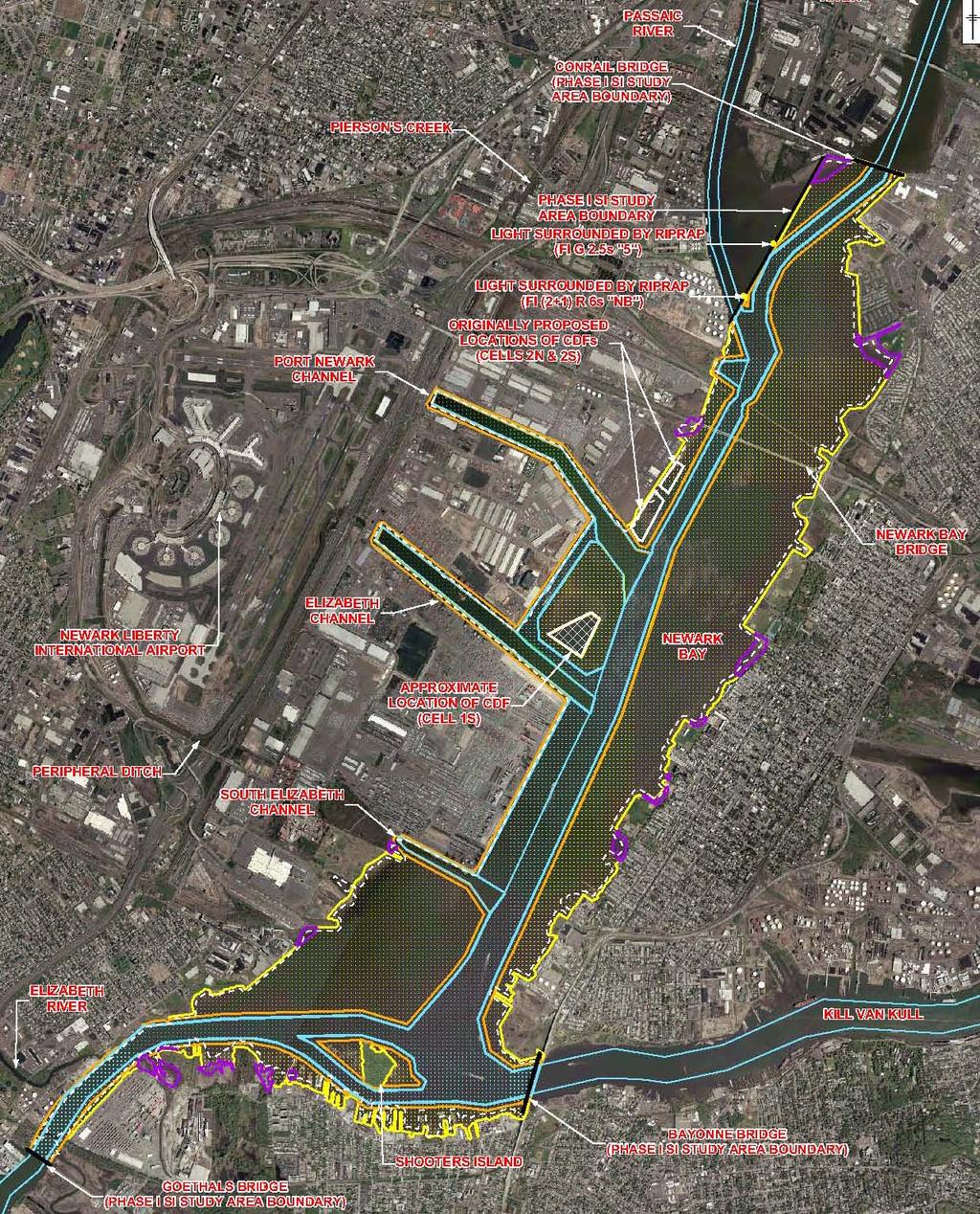
18 Geomorphic Areas 6
19 Phase 1 Program and Preliminary Findings 7
20 Primary Phase 1 Data Quality Objectives RI Goal 1 (Nature/Extent) Estimate approximate depth of 1940 horizon Understand broad patterns of contaminants of potential concern in sediments and attempt to preliminarily identify hot spots Confirm presence and extent of geomorphic areas Confirm that analytical suite is appropriate for the various geomorphic areas Determine data needs for Phase II 8
21 Phase 1 Data Quality Objectives (cont d) RI Goal 2 (Risk Assessment) Preliminarily characterize sediment contamination in ecologically sensitive inter-tidal mudflats Estimate depth of Biologically Active Zone within various geomorphic areas RI Goal 3 (Source Identification) Gather information to identify ongoing sources of contaminants Confirm (through sediment sampling) current and historical discharges impacting select areas 9
22 Bathymetric Survey 10

23 Phase 1 Bathymetric Survey Completed by Ocean Surveys, Inc., in October 2005 Performed to verify geomorphic areas and to assist field crew in locating Transitional Slope cores Bathymetric data confirmed presence of distinct geomorphic features within the Bay 11
24 Biologically Active Zone Investigation 12
 and grab samples at 14 locations across the Bay Compared field results with literature on BAZ depth Burrow Oxic Void SPI Image: NB01SED038-3")
25 Phase 1 Biologically Active Zone (BAZ) Investigation: Overview Completed in October 2005 Performed to estimate depth of the BAZ Obtained Sediment Profile Images (SPI) and grab samples at 14 locations across the Bay Compared field results with literature on BAZ depth Burrow Oxic Void SPI Image: NB01SED
26 Phase 1 Biologically Active Zone (BAZ) Investigation: Preliminary Findings BAZ depth relatively consistent across Newark Bay (approximately 6 inches) BAZ thickness corresponds well with depths estimated in other studies Note: These preliminary findings are subject to change pending Tierra s responses to USEPA comments, and based upon the receipt of new information/data. 14
27 Sediment Coring 15
28 Phase 1 Sediment Coring: Overview Field work conducted from October through December 2005 Collected sediment cores from 69 planned locations Obtained approximately 850 samples 35% for chemistry analysis 65% for radiochemistry analysis Met goal of collecting >90% of planned samples Zero safety incidents 16
29 Phase 1 Sample Locations Collected cores at 69 locations Target depths 3 cores (18) 3.5 cores (19) 4 cores (3) 5.5 cores (5) 6.5 cores (17) 8 core (1) 11 cores (6) 17


30 Phase 1 Sediment Coring: General Field Observations Sediments generally comprised of silt overlaying red clay Found limited sediment in active navigation channels 18
31 Phase 1 Sediment Coring: Analytical Chemistry Program Analyzed throughout entire cores for Semi-Volatile Organic Compounds Pesticides/PCBs PCB Congeners Herbicides Dioxins/Furans Metals (including Mercury and Cyanide) Organotins Total Extractable Petroleum Hydrocarbons VOCs 19
32 Phase 1 Sediment Coring: Analytical Chemistry Preliminary Broad Findings Sediments contaminated with numerous chemicals horizontally and vertically Highest Mercury levels in Port Newark near Pierson s Creek Highest concentrations of Total PCBs and Dioxin (2,3,7,8 TCDD) found within the northwestern Sub-tidal Flat, near the Passaic River Relatively low detection frequencies for VOCs and organotins Note: These preliminary findings are subject to change pending Tierra s responses to USEPA comments, and based upon the receipt of new information/data. 20

 Collected samples for 210 Pb and 137 Cs")
33 Phase 1 Sediment Coring: Radiochemistry Program Evaluate short and long-term deposition rates Short-term (order of months) Collected samples for 7 Be Analysis Long-term (1940 to present) Collected samples for 210 Pb and 137 Cs 21
34 Phase 1 Sediment Coring: Radiochemistry Preliminary Findings Active Navigation Channels show evidence of recent accumulation Within 6 months of sample collection Majority of Sub-tidal Flat areas show relatively low rate of sediment accumulation Isolated pockets of Sub-Tidal Flat areas experience higher sediment accumulations Potential anthropogenic (i.e., man-made) features Note: These preliminary findings are subject to change pending Tierra s responses to USEPA comments, and based upon the receipt of new information/data. 22

35 Phase 1 Source Identification Process Conducted intensive research on potential Bay sources CSOs/SWOs POTWs Hazardous waste sites Secondary tributaries Industrial facilities Obtained cores as part of Phase 1 in select waterfront locations within Bay 23
36 Phase 1 Check on Data Quality Objectives Estimate approximate depth of 1940 horizon Understand broad patterns of contaminants of potential concern in sediments and attempt to preliminarily identify hot spots Confirm presence and extent of geomorphic areas Confirm that analytical suite is appropriate for the various geomorphic areas Determine data needs for Phase II Preliminarily characterize sediment contamination in ecologically sensitive inter-tidal mudflats Estimate depth of BAZ within various geomorphic areas Gather information to identify ongoing sources of contaminants Confirm (through sediment sampling) current and historical discharges impacting select areas 24
37 Phase 2 Program Sediment Coring 25
38 Phase 2 Project Quality Objectives Characterize sediments to the 1940 horizon (target deeper cores than in Phase 1 and areas of potential high net deposition identified by USACE) Characterize sediments to understand contaminants of potential concern distribution in channels and other geomorphic areas In select regions of the Bay, compare Phase I and Phase II data Characterize surface and subsurface sediments in select areas found to be potentially impacted by upland sources 26
39 Phase 2 Program: Overview Conducted field work from October through December 2007 Phase 2 activities included only sediment coring Collected sediment cores from 50 of 52 planned locations Obtained approximately 810 samples 45% for chemistry analyses 55% for radiochemistry analyses Met goal of collecting >90% of planned samples Zero safety incidents 27

40 Phase 2 Sample Locations Collected cores at 50 of the 52 planned locations Target depths 29 deep cores 9.5 to 29.5 feet Collected all cores 23 shallow cores 0.5 feet Collected 21 of 23 cores 28

41 Phase 2 Analytical Program: Summary Vista Analytical (Alta) Dioxin/Furan Congener/Homologue Congener PCBs and Homologues Paragon Analytics 210 Pb 137 Cs 7 Be Test America (STL) Pesticides Aroclor PCBs Semi-Volatile Organic Compounds Mercury Metals Herbicides Cyanide Total Extractable Petroleum Hydrocarbons Total Organic Carbon VOCs, % moisture Note: Phase 2 did not include organotin analysis Grain Size, Specific Gravity 29
 Elizabeth River/Morse s Creek (3 cores) Penetration of the 20 planned 29.5 feet cores Achieved 29.")
42 Phase 2 Core Penetration In certain cases, penetration halted by clay, rock/till Clay encountered at 15 locations Potential High Net Deposition Areas as identified by USACE (8 cores) Sub-Tidal Flats (4 cores) Elizabeth River/Morse s Creek (3 cores) Penetration of the 20 planned 29.5 feet cores Achieved 29.5 feet at 7 of 20 locations (35%) Achieved > 20 feet at 13 of 20 locations (65%) Refusal due to rock at Location


43 Phase 2 Unexpected Conditions Location 088 at low tide Location 097 Location 088 riprap from bulkhead to channel Location 097 sunken barge and pilings Locations 099, 117 no fine-grained sediment 31
44 Next Steps Completion of laboratory analysis and data validation Data analysis and interpretation Data Assessment Report and Conceptual Site Model (Phases 1 and 2) Planning for Phase 3 32
45 QUESTIONS/DISCUSSION 33


46 US Army Corps of Engineers New York District Corps Geomorphological and Historical Study of Newark Bay Bryce Wisemiller Project Manager, Harbor Programs Branch March 5, 2008

47 US Army Corps of Engineers New York District New York & New Jersey Harbor Deepening Project DESCRIPTION: Deepen highlighted channels to 50 ft (53 in Ambrose), with Port Authority of New York and New Jersey sponsorship and support. STATUS: Deepening Construction began in 1999 In 2005, Corps began new NEPA evaluations regarding continued HDP construction in light of the AOC on the NBSA and related litigation. Corps commented to EPA in 2005 on Phase 1 work plan to sample a few known historically deep areas that were now shallow Phase 1 data appeared to support prior Corps hypothesis regarding sediment deposition patterns within Newark Bay In 2006, Corps, with consultant (Earthworks) support, expanded historical geomorphological study of Newark Bay in support of draft Environmental Assessment ELIZABETH CHANNEL SOUTH ELIZABETH CHANNEL KILL VAN KULL PORT JERSEY CHANNEL AMBROSE CHANNEL RED HOOK FLATS ANCHORAGE ANCHORAGE CHANNEL BAY RIDGE CHANNEL
 Past time periods modeled in 3D include: 1855, 1886, 1917, 1934, 1944, 1969, and 1989 Using")

48 US Army Corps of Engineers New York District Mapping Historical and Future (planned) Bay Bathymetry Using historical maps and other data sources, 3D models of Newark Bay bathymetry and shoreline were created for selected time periods (keyframes) Past time periods modeled in 3D include: 1855, 1886, 1917, 1934, 1944, 1969, and 1989 Using surveys and plans for future HDP construction and EPA s Phase 1 survey data, keyframes for present and upcoming years also modeled in 3D: 2006, Models illustrate dynamic and changing nature of Bay over past 150 years NOAA Historical Chart Search Website: s/historical_zoom.asp 1944 Chart 1989 Chart
 1855")
49 US Army Corps of Engineers New York District Bathymetry Illustrated on 2 scales (shallow and deep) 1855 Keyframe
50 US Army Corps of Engineers New York District 1934 Model Based on detailed NOAA survey (not just chart) 1855 Shoreline shown in gray for reference Numerous affected areas (fill, dredging, etc.)


51 US Army Corps of Engineers New York District Vertical Exaggeration Illustrates Perspective Views of Bay 2006 Keyframe focused on middle Newark Bay No vertical Exaggeration 6X Vertical Exaggeration
 to show details Animations Morphing Bay thru")
52 US Army Corps of Engineers New York District 3D Perspective Views of Bay at Various Keyframes 1855 Shoreline and HDP contract areas shown in gray lines for reference Vertically Exaggerated (6X) to show details Animations Morphing Bay thru Keyframes

53 US Army Corps of Engineers New York District Comparing Past (composite) Bathymetries to Present Bathymetry Composite Historical 3D Model includes deepest bathymetry value per grid cell of any keyframe from 1934 to 1989 when subtracted from 2006 bathymetry thereby showing the most significant potential depth change Darker gray indicates areas of thicker sediment accumulation at some point in time from 1934 to present Deepest deposit areas identified to EPA for consideration in Phase 2 workplan Areas of potential intersect between thick depositional areas and the remaining HDP contracts are being sampled as part of lawsuit settlement
54 Questions?
Sediment Stability in the Lower Passaic River Integration of Multiple Lines of Evidence
 Sediment Stability in the Lower Passaic River Integration of Multiple Lines of Evidence Fourth Passaic River Symposium June 22, 21 Michael Barbara, mab.consulting, LLC Marcia Greenblatt, AECOM John Connolly,
Appendix I. Dredged Volume Estimates. Draft Contractor Document: Subject to Continuing Agency Review
 Appendix I Dredged Volume Estimates Draft Contractor Document: Subject to Continuing Agency Review Interoffice Correspondence Date: April 6, 2007 To: L. Bossi (WHI) Copy: S. Thompson (WHI), B. Fidler (NNJ)
Muck. Kevin Henderson, P.E. Evergreen Engineering, Inc. Presentation to Rivers Coalition 9/29/16
 Muck Kevin Henderson, P.E. Evergreen Engineering, Inc. Presentation to Rivers Coalition 9/29/16 LITERATURE REVIEW Schropp (1994) defined muck sediments as sediment with greater than 60% silts and clays,
Data Evaluation Report No. 1: Summary of Major Sediment and Water Investigations Conducted in the Lower Passaic River
 Data Evaluation Report No. 1: Summary of Major Sediment and Water Investigations Conducted in the Lower Passaic River LOWER EIGHT MILES OF THE LOWER PASSAIC RIVER DATA EVALUATION REPORT NO. 1: SUMMARY
September 2017 Revision 3 LPROU
 (Appendix C-3 to PDI WP) Remedial Design Lower 8.3 Miles of the Lower Passaic River Operable Unit Two of the Diamond Alkali Superfund Site In and About Essex, Hudson, Bergen and Passaic Counties New Jersey
Source Control Early Action Focused Feasibility Study
 Source Control Early Action Focused Feasibility Study Empirical Mass Balance Model Results or the Lower Passaic River Edward A. Garvey, PhD, PG Malcolm Pirnie, Inc. Remedial Options Workgroup Meeting June
An Update to EPA s Conceptual Site Model for the Lower Passaic River: An Examination of the Most Recent Results
 An Update to EPA s Conceptual Site Model for the ower Passaic River: An Examination of the Most Recent Results Edward A. arvey, Alice Yeh 2, Solomon bondo-tugbawa, Juliana Atmadja, John Kern 3, AmyMarie
GIS-Based Sediment Quality Database for the St. Louis River Area of Concern (AOC): Overview Presentations and Demonstration
: Overview Presentations and Demonstration") GIS-Based Sediment Quality Database for the St. Louis River Area of Concern (AOC): Overview Presentations and Demonstration Judy L. Crane 1 and Dawn E. Smorong 2 1 Minnesota Pollution Control Agency, St.
GIS-Based Sediment Quality Database for the St. Louis River Area of Concern (AOC): Overview Presentations and Demonstration Judy L. Crane 1 and Dawn E. Smorong 2 1 Minnesota Pollution Control Agency, St.
Sediment Geotechnical Characterization Work Plan (Appendix C-2 to PDI WP)
") Sediment Geotechnical Characterization Work Plan (Appendix C-2 to PDI WP) Remedial Design Lower 8.3 Miles of the Lower Passaic River Operable Unit Two of the Diamond Alkali Superfund Site In and About
Sediment Geotechnical Characterization Work Plan (Appendix C-2 to PDI WP) Remedial Design Lower 8.3 Miles of the Lower Passaic River Operable Unit Two of the Diamond Alkali Superfund Site In and About
6 PREPARING THE SAMPLING AND ANALYSIS PLAN (SAP)
") 6 PREPARING THE SAMPLING AND ANALYSIS PLAN (SAP) Once the required numbers of DMMUs and field samples have been calculated and a dredging plan conceived, a sampling plan must be developed. The DMMUs and
6 PREPARING THE SAMPLING AND ANALYSIS PLAN (SAP) Once the required numbers of DMMUs and field samples have been calculated and a dredging plan conceived, a sampling plan must be developed. The DMMUs and
NEW YORK & NEW JERSEY HARBOR NAVIGATION CHANNEL DEEPENING
 NEW YORK & NEW JERSEY HARBOR NAVIGATION CHANNEL DEEPENING A Project Manager s Perspective Bryce Wisemiller Project Manager U.S. Army Corps of Engineers New York District US Army Corps of Engineers New
Old Stone Sewer Main Street
 Bangor Landing Bangor, Maine Case Study-Sediment Sediment Investigation Maine Department of Environmental Protection City of Bangor, with RMT, Inc. Site Location and Local Site Features 1 Bangor Landing
Historical Bathymetric Data for the Lower Passaic River
 Historical Bathymetric Data for the Lower Passaic River 4th Passaic River Symposium June 22nd, 2010 Dr. William Hansen Jeffrey Cranson Worcester State College Project Supported by The Hudson River Foundation
Lower 8.3 Miles of the Lower Passaic River Operable Unit 2 Presentation to The Passaic River Community Advisory Group. September 14, 2017
 Lower 8.3 Miles of the Lower Passaic River Operable Unit 2 Presentation to The Passaic River Community Advisory Group September 14, 2017 Agenda Pre-Design Investigation (PDI) Status Geophysical, Bathymetric,
THE QUATERNARY GEOLOGY OF NEWARK BAY AND KILL VAN KULL CHANNEL, NEW YORK AND NEW JERSEY. and
 THE QUATERNARY GEOLOGY OF NEWARK BAY AND KILL VAN KULL CHANNEL, NEW YORK AND NEW JERSEY Stephanie Beda, W. Bruce Ward, William Murphy, Robert Fleming, Gary Fleming, Beckett Boyd Earthworks LLC 27 Glen
Port of Kalama, 2013 TEMCO Berth Maintenance Dredging and In-water Flow-Lane Placement Project
 2014 WEDA ENVIRONMENTAL EXCELLENCE AWARDS Category: Navigation Dredging Port of Kalama, 2013 TEMCO Berth Maintenance Dredging and In-water Flow-Lane Placement Project Port of Kalama, Washington 18 April
LEVELS IN SOIL AND WATER. Richard Wenning 1, Andrea Von Burg 1, Linda Martello 1, John Pekala 1, Martha Maier 2, William Luksemburg 2.
 LEVELS OF POLYCHLORINATED DIBENZO-P-DIOXINS (PCDDS), DIBENZOFURANS (PCDFS), AND POLYCHLORINATED BIPHENYLS (PCBS) IN THE HACKENSACK RIVER AND NEWARK BAY, NEW JERSEY USA Richard Wenning 1, Andrea Von Burg
Remedial Investigation of Sediments in NJDEP s Site Remediation and Waste Management Program
 Remedial Investigation of Sediments in NJDEP s Site Remediation and Waste Management Program Nancy Hamill Bureau of Environmental Evaluation and Risk Assessment nancy.hamill@dep.nj.gov 609-633-1353 NJ
Sediment Traps. CAG Meeting May 21, 2012
 Sediment Traps CAG Meeting May 21, 2012 Agenda Background Fundamentals of Sediment Transport Sediment Trap Existing Information Next Steps 2 The Site Saginaw River 22 mile river beginning at confluence
Redwood City Harbor, California, Navigation Improvement Feasibility Study. Appendix D. Geotechnical Engineering. DRAFT April 2015
 1 Redwood City Harbor, California, Navigation Improvement Feasibility Study Appendix D Geotechnical Engineering DRAFT April 2015 2 Contents 1 Purposes of Report... 3 2 Background... 3 3 References and
THIN-LAYER PLACEMENT OF DREDGE MATERIAL FOR MARSH NOURISHMENT, RESOTRATION, AND RESPONSE TO SEA LEVEL RISE
 THIN-LAYER PLACEMENT OF DREDGE MATERIAL FOR MARSH NOURISHMENT, RESOTRATION, AND RESPONSE TO SEA LEVEL RISE Case studies and lesson learned regarding thin-layer deposition projects in Delaware, New Jersey,
Sampling Sediment and Porewaterin the Lower Willamette River St. Helens, Oregon. Henning Larsen, R.G. Oregon Dept of Environmental Quality
 Sampling Sediment and Porewaterin the Lower Willamette River St. Helens, Oregon Henning Larsen, R.G. Oregon Dept of Environmental Quality Columbia River Scappoose Bay Former Pope and Talbot Wood Treatment
Heather Schlosser Army Corps of Engineers Coastal Studies Group August 28, 2008
 Got sand? Regional Sediment Management in Orange County Heather Schlosser Army Corps of Engineers Coastal Studies Group August 28, 2008 Regional Sediment Management Regional sediment management recognizes
Island Design. UMRS EMP Regional Workshop. Presentation for the
 Island Design Presentation for the UMRS EMP Regional Workshop by Jon Hendrickson Hydraulic Engineer Regional Technical Specialist, Water Quality and Habitat Restoration August 17 19, 2005 Project Delivery
Planning for the Future of Humboldt Bay: Sea Level Rise, Sediment Management, Sand Spits and Salt Marshes. Joel Gerwein
 Planning for the Future of Humboldt Bay: Sea Level Rise, Sediment Management, Sand Spits and Salt Marshes Joel Gerwein Introduction to Humboldt Bay Setting Economy, community, and environment Sediment
SAGE. Systems Approach to Geomorphic Engineering. Barnegat Bay Pilot. Heather Jensen Philadelphia District. US Army Corps of Engineers BUILDING STRONG
 SAGE Systems Approach to Geomorphic Engineering Barnegat Bay Pilot Heather Jensen Philadelphia District US Army Corps of Engineers SAGE Nationwide program with a Regional Approach Innovative approach to
TECHNICAL SUPPORT FOR NY/NJ HARBOR ESTUARY PROGRAM USEPA REGION 2 TOXICS TMDL MODEL DEVELOPMENT. New York/New Jersey Harbor Estuary Program
 New York/New Jersey Harbor Estuary Program SEDIMENT AREA LOADING COMPONENT ANALYSIS AND SPREADSHEET TOOL DEVELOPMENT II HACKENSACK RIVER AND LOWER/RARITAN BAYS INTERPRETATIVE TECHNICAL MEMORANDUM TECHNICAL
Remedial Program. GE Hudson Falls Plant Site. GE Hudson Falls Plant Site. TDCS Status
 Updates on Remedial Programs at the GE Hudson Falls Plant Site and GE Fort Edward Plant Site GE Hudson Falls USEPA Community Advisory Group Meeting September 11, 2008 GE Fort Edward Division of Environmental
Highland Lake Bathymetric Survey
 Highland Lake Bathymetric Survey Final Report, Prepared For: The Town of Highland Lake 612 Lakeshore Drive Oneonta, AL 35121 Prepared By: Tetra Tech 2110 Powers Ferry Road SE Suite 202 Atlanta, GA 30339
Imagine the result Sediment Sampling Plan. 1½-Mile Reach of the Housatonic River. General Electric Company Pittsfield, Massachusetts
 Imagine the result General Electric Company Pittsfield, Massachusetts 2012 Sediment Sampling Plan 1½-Mile Reach of the Housatonic River March 2012 2012 Sediment Sampling Plan 1½-Mile Reach of the Housatonic
TABLE 1 SSFL CHEMICAL SOIL BACKGROUND STUDY DATA QUALITY OBJECTIVES
 Problem Statement: Soil chemical concentration data for selected constituents are needed from off-site chemical background reference areas (CBRAs) to establish a regulatory-compliant, publicly-reviewed,
PTM: A Lagrangian Particle Tracking Model. Joseph Gailani
 PTM: A Lagrangian Particle Tracking Model Joseph Gailani Joe.Z.Gailani@usace.army.mil OUTLINE Motivation for sediment/constituent modeling system Objectives of modeling system Description of PTM PTM Example
Material Workshop. Galveston District 2012 Beneficial Use of Dredged. Material Workshop. Custodians of the Coast
 Galveston District 2012 Beneficial Use of Dredged Material Workshop Galveston District 2012 Beneficial Use of Dredged Material Workshop US Army Corps of Engineers BUILDING STRONG Welcome Opening Remarks
CREATING USACE SPATIAL DATA STANDARDS-COMPLIANT GEODATABASES FOR STORAGE AND RETRIEVAL OF SPATIALLY REFERENCED DREDGE MATERIAL ANALYTICAL RESULTS
 CREATING USACE SPATIAL DATA STANDARDS-COMPLIANT GEODATABASES FOR STORAGE AND RETRIEVAL OF SPATIALLY REFERENCED DREDGE MATERIAL ANALYTICAL RESULTS Christine Smith 1, Nadia Lombardero 2, and Philip M. Wolf
Regional-scale understanding of the geologic character and sand resources of the Atlantic inner continental shelf, Maine to Virginia
 Regional-scale understanding of the geologic character and sand resources of the Atlantic inner continental shelf, Maine to Virginia Workshop on Dredging, Beach Nourishment and Bird Conservation Atlantic
3. MARINE HABITAT RESTORATION
 Feasibility Study for Restoration of Titlow Lagoon Fish Passage South Puget Sound Salmon Enhancement Group 3. MARINE HABITAT RESTORATION Marine habitat restoration at Titlow Park could include restoration
South San Francisco Bay Shoreline Studies for EIA 11 with Project Conditions
 South San Francisco Bay Shoreline Studies for EIA 11 with Project Conditions U.S. Army Corps of Engineers San Francisco District Ms. Lisa Andes Mr. Craig Conner Dr. Frank Wu Dr. Jen-Men Lo Dr. Michael
Aquatic Transfer Facility (ATF) San Pablo Bay (SPB) Proposed Region of ATF. Proposed Seabed Pipeline
 San Pablo Bay (SPB) Proposed Region of ATF. Proposed Seabed Pipeline") Aquatic Transfer Facility (ATF) San Pablo Bay (SPB) Proposed Region of ATF Proposed Seabed Pipeline Technical Studies An Overview Scope: Provide background and new scientific information and analysis for
Aquatic Transfer Facility (ATF) San Pablo Bay (SPB) Proposed Region of ATF Proposed Seabed Pipeline Technical Studies An Overview Scope: Provide background and new scientific information and analysis for
Four Mile Run Levee Corridor Stream Restoration
 Four Mile Run Levee Corridor Stream Restoration 30% Design Summary U.S. Army Corps of Engineers, Baltimore District Presentation Outline Four Mile Run 1.) Historic Perspective 2.) Existing Conditions 3.)
EAGLES NEST AND PIASA ISLANDS
 EAGLES NEST AND PIASA ISLANDS HABITAT REHABILITATION AND ENHANCEMENT PROJECT MADISON AND JERSEY COUNTIES, ILLINOIS ENVIRONMENTAL MANAGEMENT PROGRAM ST. LOUIS DISTRICT FACT SHEET I. LOCATION The proposed
Stickney Avenue Depositional Zone (SADZ) Investigation
 Investigation") The Ottawa River: A Report to the Community Stickney Avenue Depositional Zone (SADZ) Investigation May 22, 2007 Presented by: Scott Bell, P.E., BCEE (LimnoTech) Kelly Bensman (Hull & Associates) SADZ Location
The Ottawa River: A Report to the Community Stickney Avenue Depositional Zone (SADZ) Investigation May 22, 2007 Presented by: Scott Bell, P.E., BCEE (LimnoTech) Kelly Bensman (Hull & Associates) SADZ Location
Presented By Quarterly Public Meeting February 22, 2012
 West Valley Phase 1 Studies Update Presented By Quarterly Public Meeting February 22, 2012 Agenda Status of Erosion PAS Status of Climate Change Workshop Status of ISP Looking Ahead Near - Term Timeline
Lower 8.3 Miles of the Lower Passaic River Operable Unit 2 Presentation to the Passaic River Community Advisory Group.
 Lower 8.3 Miles of the Lower Passaic River Operable Unit 2 Presentation to the Passaic River Community Advisory Group March 15, 2018 Agenda Sediment sampling collection metrics Continuing Pre-Design Investigation
Great Lakes Update. Volume 188: 2012 Annual Summary
 Great Lakes Update Volume 188: 2012 Annual Summary Background The U.S. Army Corps of Engineers (USACE) tracks the water levels of each of the Great Lakes. This report highlights hydrologic conditions of
Lessons Learned from Fish Spawning Reef Restoration in the St. Clair Detroit River System. Photo Credit: Adam Lintz
 Lessons Learned from Fish Spawning Reef Restoration in the St. Clair Detroit River System Photo Credit: Adam Lintz Outline and Presenters Jennifer Read, University of Michigan Water Center Introduction
DRAFT ONONDAGA LAKE CAPPING AND DREDGE AREA AND DEPTH INITIAL DESIGN SUBMITTAL H.4 SEISMIC SLOPE STABILITY ANALYSES
 DRAFT ONONDAGA LAKE CAPPING AND DREDGE AREA AND DEPTH INITIAL DESIGN SUBMITTAL H.4 SEISMIC SLOPE STABILITY ANALYSES Parsons P:\Honeywell -SYR\444576 2008 Capping\09 Reports\9.3 December 2009_Capping and
Location: Jacksonville, FL December 11, 2012
 Technical Update Meeting Northeast Florida Surge Study Location: Jacksonville, FL December 11, 2012 Agenda 2:00 2:15 Welcome/Introductions Tucker Mahoney, FEMA Region IV Michael DelCharco, BakerAECOM 2:15
PROFESSIONAL SERVICES DESCRIPTION FOR THE POSITION OF:
 PROFESSIONAL SERVICES DESCRIPTION FOR THE POSITION OF: Paulsboro Marine Terminal Sediment and Benthic Sampling and Characterization Plan Addendum No. 1 SUBMISSION DEADLINE: May 27, 2009 at 11:00 A.M. FAIR
MEMORANDUM. Scott Pickard, CELRB-TD-EH Michael Asquith, CELRB-PM-PM. From: Paul R. Schroeder, Ph.D., PE Earl Hayter, Ph.D. Date: 14 March 2016
 DEPARTMENT OF THE ARMY ENGINEER RESEARCH AND DEVELOPMENT CENTER, CORPS OF ENGINEERS ENVIRONMENTAL LABORATORY WATERWAYS EXPERIMENT STATION, 3909 HALLS FERRY ROAD VICKSBURG, MISSISSIPPI 39180-6199 29 November
Coastal Response Research Center. Nancy Kinner University of New Hampshire (UNH) Michele Jacobi NOAA ORR. September 27, 2007
 Michele Jacobi NOAA ORR. September 27, 2007") Coastal Response Research Center Nancy Kinner University of New Hampshire (UNH) Michele Jacobi NOAA ORR September 27, 2007 1 Coastal Response Research Center (CRRC) CRRC is partnership between NOAA s Office
Coastal Response Research Center Nancy Kinner University of New Hampshire (UNH) Michele Jacobi NOAA ORR September 27, 2007 1 Coastal Response Research Center (CRRC) CRRC is partnership between NOAA s Office
Illinois River Sediment Quality and Beneficial Use Options
 Illinois River Sediment Quality and Beneficial Use Options John C. Marlin Illinois Sustainable Technology Center Robert G. Darmody Dept. of Natural Resources and Environmental Science University of Illinois
Assessment of the Hood River Delta Hood River, Oregon
 Assessment of the Hood River Delta Hood River, Oregon Pacific Northwest Waterways Association Annual Meeting October 13, 2010 Michael McElwee, Executive Director Port of Hood River Overview U.S. Army Corps
Estimating Remedial Volumes for a GLLA Project on the Milwaukee River
 Estimating Remedial Volumes for a GLLA Project on the Milwaukee River Mike Ciarlo, Jamie Beaver, Mike Powell, Jason Byler EA Engineering, Science, and Technology, Inc. Marsha Burzynski, William Fitzpatrick
Lower Snake River Programmatic Sediment Management Plan Final Environmental Impact Statement
 U.S. Army Corps of Engineers Walla Walla District Lower Snake River Programmatic Sediment Management Plan Final Environmental Impact Statement EXECUTIVE SUMMARY August 2014 EXECUTIVE SUMMARY Introduction
Appendix O. Sediment Transport Modelling Technical Memorandum
 Appendix O Sediment Transport Modelling Technical Memorandum w w w. b a i r d. c o m Baird o c e a n s engineering l a k e s design r i v e r s science w a t e r s h e d s construction Final Report Don
Imagine the result. Sediment Investigation Work Plan. Former Tidewater Facility
 Imagine the result Sediment Investigation Work Plan Former Tidewater Facility July 2008 Sediment Investigation Work Plan Former Tidewater Facility Prepared for: National Grid Prepared by: ARCADIS 100 Cummings
Estimated Sediment Volume: Bridge Street Dam Impoundment, Royal River, Yarmouth, Maine
 University of Southern Maine USM Digital Commons Publications Casco Bay Estuary Partnership (CBEP) 2015 Estimated Sediment Volume: Bridge Street Dam Impoundment, Royal River, Yarmouth, Maine Stantec Follow
Putting the Pieces of the Puzzle Together. By Kim Kirkland, Methods Team Leader EPA s Office of Resource Conservation and Recovery
 Putting the Pieces of the Puzzle Together By Kim Kirkland, Methods Team Leader EPA s Office of Resource Conservation and Recovery Topics to Be Covered Item 1 Brief Review of Current Method Team Projects
MEMORANDUM FOR SWG
 MEMORANDUM FOR SWG-2007-1623 Subject: Jurisdictional Determination (JD) for SWG-2007-1623 on Interdunal Wetlands Adjacent to Traditional Navigable Waters (TNWs) Summary The U.S. Environmental Protection
GROUNDWATER MONITORING DATA 2016 SAMPLING EVENT HARSHAW CHEMICAL COMPANY FUSRAP SITE
 GROUNDWATER MONITORING DATA 2016 SAMPLING EVENT HARSHAW CHEMICAL COMPANY FUSRAP SITE U.S. Army Corps of Engineers Buffalo District Building Strong April 2017 ly Utilized Sites Remedial Action Program The
SOUTHEAST COASTAL ASSESSMENT: Creating a shared vision
 SOUTHEAST COASTAL ASSESSMENT: Creating a shared vision November 12, 2017 Jacqueline Keiser, PG, PMP Regional Sediment Management Regional Center of Expertise SOUTH ATLANTIC DIVISION U.S. ARMY CORPS OF
Southern California Dredged Material Management Team (SC-DMMT) May 26, 2010 Meeting Notes
 May 26, 2010 Meeting Notes") Southern California Dredged Material Management Team (SC-DMMT) May 26, 2010 Meeting Notes I. SC-DMMT Participating Agencies a. Jorine Campopiano EPA b. Allan Ota - EPA c. Mike Lyons LARWQCB d. Larry Simon
Southern California Dredged Material Management Team (SC-DMMT) May 26, 2010 Meeting Notes I. SC-DMMT Participating Agencies a. Jorine Campopiano EPA b. Allan Ota - EPA c. Mike Lyons LARWQCB d. Larry Simon
TECHNICAL MEMORANDUM June 16, 2011
 TECHNICAL MEMORANDUM June 16, 2011 Tier 1 Remedial Investigation Results and Tier 2 Sampling Plan Former Salinas Manufactured Gas Plant To: Mr. Henry Chui, Department of Toxics Substances Control From:
Annual transport rates at two locations on the fore-slope.
 Sediment Transport by Currents Fore-slope Sediment transport rates and sediment concentrations were computed from the hydrodynamic model runs as well as from direct measurements of current velocities at
Sediment management for a living river - the Lahn River case
 Sediment management for a living river - the Lahn River case Alexandra Brinke, Denise Spira, Michael Schleuter, Georg Reifferscheid, Peter Heininger & Ute Feiler Federal Institute of Hydrology, Germany
Regional Sediment Management: The Long Island Coastal Planning Project
 Regional Sediment Management: The Long Island Coastal Planning Project Lynn M. Bocamazo Senior Coastal Engineer USACE-New York District 22 September 2009 US Army Corps of Engineers Outline Project Location
Aquitard Characterization The Legend of Indiana s Magic Clay Layer. Juliet Port, LPG #2214 July 2014
 Aquitard Characterization The Legend of Indiana s Magic Clay Layer Juliet Port, LPG #2214 July 2014 Topics What is an Aquitard? Why do we care? Review of Indiana glacial geology Conceptual Framework Investigation
Geographic Response Plan Mapping and Digital Area Contingency Plan
 Geographic Response Plan Mapping and Digital Area Contingency Plan Ryan Druyor Digital ACP Coordinator Florida Fish and Wildlife Conservation Commission Fish and Wildlife Research Institute Background
Conceptual Site Model for Newark Bay Hydrodynamics and Sediment Transport
 J. Mar. Sci. Eng. 2014, 2, 123-139; doi:10.3390/jmse2010123 Article OPEN ACCESS Journal of Marine Science and Engineering ISSN 2077-1312 www.mdpi.com/journal/jmse Conceptual Site Model for Newark Bay Hydrodynamics
Table 5-1 Sampling Program Summary for Milltown Ford Avenue Redevelopment Area, NJ.
 Table 5- Sampling Program Summary for Milltown Ford Avenue Redevelopment Area, NJ. Transformer Pads (9 pads: PAD 9) Evaluate if PCBs presently exist in soils adjacent to, and/or beneath the transformer
Long-Distance Pumping and Opportunities for Engineering with Nature
 Long-Distance Pumping and Opportunities for Engineering with Nature Tim Welp and Derek Wilson Tim Welp Research Hydraulic Engineer Coastal and Hydraulics Laboratory 23 October 2012 Engineering with Nature
GALVESTON BAY RSM Moving toward an Integrated, Cooperative, and Holistic Approach to Estuarine Sediments
 GALVESTON BAY RSM Moving toward an Integrated, Cooperative, and Holistic Approach to Estuarine Sediments RAE Conference 2010 Larry A. Wise Moffatt & Nichol RSM is a system-based approach for collaboratively
Seagrass Transplantation & Environmental & Marine Consulting Services, Inc. Drew Campbell, Vice President & Lead Scientst.
 Indian River Lagoon Symposium Seagrass Transplantation & Project Considerations Environmental & Marine Consulting Services, Inc. Drew Campbell, Vice President & Lead Scientst March 26 th, 2013 Regulatory
Lu, S., P. Craig, C. Wallen, Z. Liu, A. Stoddard, W. McAnnally and E. Maak. Dynamic Solutions, Knoxville, TN USACOE, Sacramento District
 An Extended-Delta Hydrodynamic Model Framework for Sea Level Rise Analysis to Support Resource Management Planning for the Sacramento-San Joaquin River Delta Lu, S., P. Craig, C. Wallen, Z. Liu, A. Stoddard,
THE PORTFIELDS INITIATIVE: REVITALIZING BROWNFIELDS IN PORT COMMUNITIES
 THE PORTFIELDS INITIATIVE: REVITALIZING BROWNFIELDS IN PORT COMMUNITIES Kenneth Walker, NOAA Office of Ocean and Coastal Resource Management Robert Neely, NOAA Office of Response and Restoration David
Surface Processes Focus on Mass Wasting (Chapter 10)
") Surface Processes Focus on Mass Wasting (Chapter 10) 1. What is the distinction between weathering, mass wasting, and erosion? 2. What is the controlling force in mass wasting? What force provides resistance?
Surface Processes Focus on Mass Wasting (Chapter 10) 1. What is the distinction between weathering, mass wasting, and erosion? 2. What is the controlling force in mass wasting? What force provides resistance?
Bishopville Prong Study
 Bathymetric and Sediment Assessment in the Bishopville Prong of St. Martin River Darlene V. Wells, Richard A. Ortt, Jr., and Stephen Van Ryswick Funded by MCBP 2011-2012 Implementation Grant Objectives
Volatile Losses from Aged Field Sediments
 Volatile Losses from Aged Field Sediments PURPOSE: This technical note describes laboratory investigations conducted to obtain flux data from contaminated aged field sediments and a laboratory spiked sediment
Appendix G.19 Hatch Report Pacific NorthWest LNG Lelu Island LNG Maintenance Dredging at the Materials Offloading Facility
 Appendix G.19 Hatch Report Pacific NorthWest LNG Lelu Island LNG Maintenance Dredging at the Materials Offloading Facility Project Memo H345670 To: Capt. David Kyle From: O. Sayao/L. Absalonsen December
USEPA National Watershed Protection Program NY/NJ Harbor Estuary Program USEPA Region 2 New York, New York. USEPA Contract EP-C
 USEPA National Watershed Protection Program NY/NJ Harbor Estuary Program USEPA Region 2, EVALUATION OF AMMONIA TOXICITY IN THE NY/NJ HARBOR WITHIN THE CONTEXT OF NITROGEN AND CARBON TMDL PLANNING FOR ATTAINMENT
June 2018 Sediments and Dredging at GBR Ports
 June 2018 Sediments and Dredging at GBR Ports Reef 2050 Long Term Sustainability Plan The Great Barrier Reef is over 2000 km long and covers an area of approximately 350,000 square kilometres. It is a
RITS Fall 2009 Getting the Most Out of Your Conceptual Site Model 1
 of Your Conceptual Site Model 1 of Your Conceptual Site Model 2 of Your Conceptual Site Model 3 of Your Conceptual Site Model 4 of Your Conceptual Site Model 5 The CSM is a comprehensive representation
MINUTES NAVAL WEAPONS STATION (NAVWPNSTA) SEAL BEACH RESTORATION ADVISORY BOARD (RAB) AND COMMUNITY MEETING SITE TOUR July 12, 2010
 SEAL BEACH RESTORATION ADVISORY BOARD (RAB) AND COMMUNITY MEETING SITE TOUR July 12, 2010") MINUTES NAVAL WEAPONS STATION (NAVWPNSTA) SEAL BEACH RESTORATION ADVISORY BOARD (RAB) AND COMMUNITY MEETING SITE TOUR July 12, 2010 Participants: Blake, Geoffrey / RAB Community Member Broderick, John
MINUTES NAVAL WEAPONS STATION (NAVWPNSTA) SEAL BEACH RESTORATION ADVISORY BOARD (RAB) AND COMMUNITY MEETING SITE TOUR July 12, 2010 Participants: Blake, Geoffrey / RAB Community Member Broderick, John
Improvements to Southeast Louisiana s floodwalls and pump stations since Katrina: the Hurricane and Storm Damage Risk Reduction System (HSDRRS)
") Improvements to Southeast Louisiana s floodwalls and pump stations since Katrina: the Hurricane and Storm Damage Risk Reduction System (HSDRRS) Pat Fitzpatrick Mississippi State University Review of levee
Improvements to Southeast Louisiana s floodwalls and pump stations since Katrina: the Hurricane and Storm Damage Risk Reduction System (HSDRRS) Pat Fitzpatrick Mississippi State University Review of levee
REDWOOD VALLEY SUBAREA
 Independent Science Review Panel Conceptual Model of Watershed Hydrology, Surface Water and Groundwater Interactions and Stream Ecology for the Russian River Watershed Appendices A-1 APPENDIX A A-2 REDWOOD
BUFFALO RIVER COALITION PO Box 101, Jasper, AR (870)
") BUFFALO RIVER COALITION PO Box 101, Jasper, AR 72641 (870) 446-5783 buffalowatershed@gmail.com Presentation before Arkansas Pollution Control and Ecology Commission, April 29, 2016 by Richard Mays on behalf
BUFFALO RIVER COALITION PO Box 101, Jasper, AR 72641 (870) 446-5783 buffalowatershed@gmail.com Presentation before Arkansas Pollution Control and Ecology Commission, April 29, 2016 by Richard Mays on behalf
Oak Ridge Environmental Information System (OREIS): Formalizing the Shapes of Things on the Oak Ridge Reservation 15393
: Formalizing the Shapes of Things on the Oak Ridge Reservation 15393") Oak Ridge Environmental Information System (OREIS): Formalizing the Shapes of Things on the Oak Ridge Reservation 15393 Patricia J. Halsey, Lacey Wicks (OREM Summer Intern) U.S. Department of Energy Peter
Oak Ridge Environmental Information System (OREIS): Formalizing the Shapes of Things on the Oak Ridge Reservation 15393 Patricia J. Halsey, Lacey Wicks (OREM Summer Intern) U.S. Department of Energy Peter
INDIANA HARBOR AND CANAL AIR MONITORING DATA ANALYSIS
 INDIANA HARBOR AND CANAL AIR MONITORING DATA ANALYSIS Prepared by U.S. Army Corps of Engineers Chicago District July 25, 2014 1 This Page Left Intentionally Blank 2 INDIANA HARBOR AND CANAL AIR MONITORING
SEDIMENT MANAGEMENT WORK GROUP UPDATE
 SEDIMENT MANAGEMENT WORK GROUP UPDATE RTDF Sediment Remediation Action Team Meeting and Workshop on In Situ Treatment Technologies for Contaminated Sediments Baltimore, February 18-19, 2004 Presented by:
Relatively little hard substrate occurs naturally in the
 CHAPTER FIVE Rock Habitats Relatively little hard substrate occurs naturally in the estuary, owing mainly to the vast quantities of fine sediment that have been deposited by the rivers. Rock habitat is
East Branch Grand Calumet River Great Lakes Legacy Act Sediment Remediation and Restoration Project
 East Branch Grand Calumet River Great Lakes Legacy Act Sediment Remediation and Restoration Project Jointly funded by the U.S. EPA Great Lakes Legacy Act, Indiana Department of Environmental Management
ERDC Update SAD Regional Management Board
 ERDC Update SAD Regional Management Board José E. Sanchez, P.E., SES Director, Coastal and Hydraulics Laboratory Engineer Research and Development Center 14FEB17 Overview of R&D Activities in AOR Cross
Final Survey/Data Report
 US ARMY CORPS OF ENGINEERS New England District Contract No. DACW33-03-D-004 Delivery Order No. 05 November 2004 Final Survey/Data Report Boston Harbor Deep Draft Navigation Improvement Project Biological
Former Williams AFB Restoration Advisory Board (RAB)
") Headquarters U.S. Air Force I n t e g r i t y - S e r v i c e - E x c e l l e n c e Former Williams AFB Restoration Advisory Board (RAB) November 16, 2010 Highland High School 4301 E. Guadalupe Rd. Gilbert,
Headquarters U.S. Air Force I n t e g r i t y - S e r v i c e - E x c e l l e n c e Former Williams AFB Restoration Advisory Board (RAB) November 16, 2010 Highland High School 4301 E. Guadalupe Rd. Gilbert,
GM POWERTRAIN BEDFORD FACILITY BEDFORD, INDIANA
 GM POWERTRAIN BEDFORD FACILITY BEDFORD, INDIANA Welcome to the October 2007 Public Information Session October 11, 2007 Facility located on 152.5 acres and is approximately 1,000,000 square feet Approximately
MISSISSIPPI COASTAL IMPROVEMENTS
 MISSISSIPPI COASTAL IMPROVEMENTS PROGRAM (MsCIP) Comprehensive Barrier 237 27 200 237 27 200 Island 237 Restoration 27 200 Plan 80 9 27 252 74.59 255 255 255 0 0 0 63 63 63 3 32 22 239 65 53 0 35 20 2
Precision of Environmental Dredging Factors and Processes
 Precision of Environmental Dredging Factors and Processes Michael Palermo - Mike Palermo Consulting, Inc. John Kern Kern Statistical Services, Inc. Presented at DREDGING 2012 October 22-25, 2012, San Diego,
Observed bed elevation changes in the data may arise as a result of any of several causes:
 10 July 2014 TECHNICAL MEMORANDUM: INTRODUCTION NEWARK BAY STUDY AREA, NEW JERSEY BATHYMETRIC COMPARISON AND ANALYSIS Periodic single- and multi-beam sonar bathymetric surveys within Newark Bay (Bay) in
IN SITU SPECIFIC GRAVITY VS GRAIN SIZE: A BETTER METHOD TO ESTIMATE NEW WORK DREDGING PRODUCTION
 IN SITU SPECIFIC GRAVITY VS GRAIN SIZE: A BETTER METHOD TO ESTIMATE NEW WORK DREDGING PRODUCTION Nancy Case O Bourke, PE 1, Gregory L. Hartman, PE 2 and Paul Fuglevand, PE 3 ABSTRACT In-situ specific gravity
NATURAL RECOVERY: MONITORING DECLINES IN SEDIMENT CHEMICAL CONCENTRATIONS AND BIOLOGICAL ENDPOINTS WORKING DRAFT, JUNE 2004
 NATURAL RECOVERY: MONITORING DECLINES IN SEDIMENT CHEMICAL CONCENTRATIONS AND BIOLOGICAL ENDPOINTS WORKING DRAFT, JUNE 2004 Clay Patmont (cpatmont@anchorenv.com, Anchor Environmental, Seattle, Washington,