Disaster Mitigation Efforts in Indonesia
|
|
|
- Chester Martin
- 6 years ago
- Views:
Transcription

1 State Ministry of Research and Technology Republic of Indonesia Disaster Mitigation Efforts in Indonesia presented at Second Asian Science and Technology Forum Tokyo, 8 September 2006 by Dr. Idwan Suhardi Deputy Minister for Utilization and Dissemination of Research and Technology State Ministry of Research and Technology Republic of Indonesia page 1
2 OUTLINE 1. INTRODUCTION 2 RECENT DISASTER 3. CURRENT STATUS OF INDONESIAN TSUNAMI EARLY WARNING SYSTEMS 4. END-TO TO-END TSUNAMI SIMULATION IN PADANG CITY ON 26 DECEMBER 2005 page 2

3 1. INTRODUCTION page 3

 and west-northwestward (near Yap trench) Every year")
4 Tectonic Setting and Seismicity of Indonesia The Indonesian region very complicated plates convergence : subduction, collision, back-arc thrusting, back-arc and opening faults Moving relatively to each other the India-Australia plate : moving northward the Philippine sea plate : moving west-northwestward. the Caroline plate : moving east-southeastward (near Aru) and west-northwestward (near Yap trench) Every year about 460 earthquakes (M > 4.0 ) page 4


 TSUNAMI) :: 86 86")
5 Earthquake and Tsunami History EARTHQUAKE EARTHQUAKE WITH WITH M M RS RS IN IN INDONESIA, INDONESIA, A. A. TOTAL TOTAL :: B. B. IN IN THE THE SEA SEA C. C. SHALLOW SHALLOW IN IN THE THE SEA SEA :: (( % % )) D. D. GENERATED GENERATED TSUNAMI) TSUNAMI) :: (( % % )) :: (( % % )) modified from : Latif and Guisakof page 5
6 Earthquake Events in Indonesia EARTHQUAKE with MAGNITUDE 7.0 RS ( ) TOTAL NUMBER OF Earthquakes = 1968 event 212 event 11% Indonesia 1756 event 89% Out of Indonesia page 6
7 2. Recent Disaster Aceh Tsunami Merapi Eruption Jogja Earthquake Pangandaran Tsunami page 7


8 Tsunami Aceh : a brief reminder 132,000 confirmed dead 37,000 missing 572,000 displaced 1.3 million homes and buildings destroyed 8 ports and 4 fuel deports damaged 85% of the water and 92% of the sanitation system broke down 120 km of roads and 18 main bridges demolished total losses amount to US$ 4.5 billion, which represents 2.2% of National GDP and 97% of Aceh s GDP page 8
9 the causes Catastrophic earthquake Scale 9 with shallow epicenter offshore Very strong ground shaking for 4 minutes felt in many areas People moved out of their houses out of fear Followed by a tsunami Wave height ranging from 4 35 m Most people have never seen such calamity in their lives Did not know what to do chaotic No warning was issued page 9


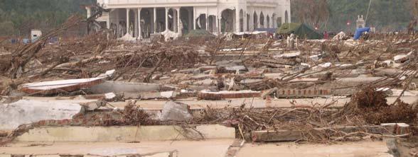


10 What remains page 10


11 Volcanic Eruption : Mount Merapi page 11

 no casualties, but two people")
12 The Merapi Cycle During the period of 1006 to 2001 Mount Merapi has erupted 82 times. Short cycle 2-5 years Medium cycle 5-7 years The last three eruptions (1997, 1998, 2001) no casualties, but two people died during 2006 eruption. page 12


13 The Jogja Earthquake, 27 May 2006 Earthquake with 5.9 SR 6,234 people died 7,057 houses collapse, including several historical sites Jogja airport was closed for several days Total losses is estimated at US$ 3 billion page 13

14 Earthquake and Tsunami, 17 July 2006 page 14


15 the victims page 15


16 maximum : 7 m wave Location Longitude Latitude Inundation height Pameungpeuk 107:41:26.6E 7:40:05.9S 5.20m Sindangkerta 108:03:35.7E 7:45:52.8S 3.74m+ 108:24:09.9E 7:48:56.0S 3.67m 108:26:32.1E 7:49:10.2S 5.9m Batukaras 108:29:51.3E 7:44:48.6S 2.12m Batu Hiu 108:32:09.4E 7:41:31.9S 5.34m Bulak Laut 108:36:43.3E 7:41:01.2S 7.67m Pangandaran 108:39:06.0E 7:41:37.6S 4.69m Widara Payung 109:15:51.8E 7:41:53.2S 6.70m+ page 16
17 2. CURRENT STATUS OF INDONESIAN TEWS page 17
18 in response to Aceh tsunami, Government formed the Reconstruction and Rehabilitation Agency (BRR) Ministry of Research and Technology responsible in coordinating various agencies in the Development of Tsunami Warning Systems throughout Indonesia KLH DEPLU ESDM KOMINFO BAPPENAS BAKORNAS PBP BAKOSURTANAL BPPT LAPAN LIPI BMG DKP ITB page 18
19 Summary of Grand-scenario Geo Input Sensing Devices : Seismometer Accelerometer OBU : - Seismometer - Accelerometer - Pressure GPS Transmit Data : Bottom to Surface, Surface to center Processing Center Transmit Information : SR/MMI Location (LS+BT) Depth Time Predict : Tsunami? Recipients : Bakornas Satkorlak Satlak Media Recipients : Bakornas Satkorlak Satlak Media COMMUNITY page 19

20 Schematic Diagram of Basic Design page 20
21 Satellite in Indian Ocean Satellite in Pacific system HAA GTS or ACeS Regional/National Center GPS Coastal station Coastal station Seismograph Buoy Tide gage Bottom pressure gauge OBS Indian Ocean Plate Jan Sopaheluwakan, 2005 page 21
22 System Elements Seismic Monitoring Seismograph Accelerograph Database of Tsunami Modeling Sea level monitoring DART - BUOY Tide Gauge Information and Communication Technology Crustal Deformation Monitoring GPS Geospatial Information Satellite Imagery Topographic and Bathymetric map Community Preparedness Capacity Building page 22

23 Seismic Monitoring NO DEVICE PLANNED EXISTING 1 SEISMOGRAPH 160 units scattered in 10 Regional Offices issue warning within 5 minutes 58 units scattered in 5 Regional Offices issue warning within minutes 2 ACCELEROGRAPH 500 Units 9 Units page 23
 120 units of digital tidal recording page 24")
24 Sea level Monitoring DEVICE EXISTING PLAN TIDE GAUGE 60 units (35 analog graphical chart and 25 digital tidal recording) 120 units of digital tidal recording page 24


25 Oceanographic Monitoring DEVICE EXISTING PLANNED DART-BUOY 12 Units to only monitor sea environment 22 Units of Ocean Bottom Pressure Sensors page 25


26 Crustal Deformation Monitoring Plan to install Continuous GPS ( 27 GPS near tide gauges and 10 GPS near Buoys) page 26

27 Tsunami Modeling 16 of 109 tsunamis have been simulated 1. The 1797 West Sumatran Tsunami 2. The 1818 Bali Tsunami 3. The 1820 Bima Tsunami 4. The 1833 Bengkulu Tsunami 5. The 1883 Krakatau Volc Tsunami 6. The 1935 North Sumatera Tsunami 7. The 1969 Mandar Tsunami 8. The 1992 Flores Tsunami 9. The 1994 East Java Tsunami 10. The 1996 Toli-Toli Tsunami 11. The 1996 Biak Tsunami 12. The 1998 PNG Tsunami 13. The 2000 Banggai Tsunami 14. The 2004 Aceh Tsunami 15. The 2005 Nias Tsunami 16. The 2006 Pangandaran Friday, 8 September Tsunami 2006 page 27


")
28 The 2004 Aceh Tsunami Tsunami Height Distribution Tsunami Inundation Latief, Aditya, Haris, (2005) page 28

29 page 29
")
30 Numerical Modeling (Pangandaran 17 July 2006) page 30
31 End-to to-end Tsunami Simulation in Padang City on 26 December 2005 page 31
32 Tsunami Prone Area in the World PADANG City (Source : Geographica) page 32


33 Community Preparedness Tsunami in Indonesia are local type Generated very close to coastal communities Insufficient time to accurately assess the risk Less time to disseminate warnings and carry out orderly evacuation page 33

34 Seismological Summary of Sumatera Padang (Natawidjaya, 2002) Several big earthquake have been recorded in the West Coast of Sumatra (e.g. 1833, 1935 and 2004) and initiated tsunami disaster. Based on paleo-tsunami research, the next big earthquake with tsunami is forecasted to occur at Padang page 34

35 page 35
36 Statistics of Padang City Geographical Position : S Area : km2 Inhabitants : 901,488 people Coast length : +/- 84 km Number of surrounding rivers : 21 Altitude : 0 10 m (60%) page 36


37 Public Education Materials page 37


38 National Media Campaign page 38


39 Local Media Campaign page 39


40 Distributed Materials and Previous Exercise Hazard Map Evacuation Routes Learning media Earthquake and tsunami drill page 40

41 Increasing Awareness for Government Officers page 41


42 Workshop for Developing Evacuation Map page 42


43 TOT for Local Officers, Students, NGO and Public page 43


44 TOT for Local Officers, Students, NGO and Public page 44


45 Tsunami Model for Padang City Tsunami numerical simulation is under-development for Padang area based on the 1833 earthquake. The model would be able to simulate tsunami run-up and predicts the available time for evacuation purposes Please wait take some time to run the program page 45

46 Elevation of Padang City : 0-5 mdpl : 5 10 mdpl : mdpl : mdpl : > 100 mdpl : Danger Zone : Alert Zone : Safe Zone : Relocation Zone : Relocation Zone Safe Area: > 5 meters above sea-level Kogami page


47 Evacuation Map and Sign Boards Documentation LIPI page 47

48 Evacuation Routes and Escape Building page 48

49 Evacuation Routes and Escape Building KAMPUS UNAND INDARUNG BY PASS TELUK BAYUR LUBUK BEGALUNG SIMPANG HARU JL. RADEN SALEH PUSAT KOTA page 49

50 Evacuation Routes and Escape Building BY-PASS/BALAI BARU BY-PASS RAWANG PANJANG SITEBA TUNGGUL HITAM LAPAI ULAK KARANG TABING/AIR TAWAR page 50

51 Evacuation Routes and Escape Building LUBUK MINTURUN BY PASS PARAK BURUAK ANAK AIR SIMPANG TABING BY PASS BY PASS SIMPANG LALANG LUBUK BUAYA SIMPANG KALUMPANG SIMPANG DUKU BEBERAPA JALUR DAN TITIK EVAKUASI SUMBER: Dinas Prasarana Jalan Propinsi Sumbar page 51

52 DTM of Padang page 52

 to Major of")
 by Pushing Red")


53 Commemoration of One-year Tsunami Disaster Sending warning from National Center (BMG) to Major of Padang City (Authorized person) by Pushing Red Button People went to the designed evacuation place (Pangilun Mountain) Activities at the Evacuation Place page 53
 as a part of")

54 Real time Earthquake Monitoring Indonesia, with the aids from several other countries, have established additional 11 seismometer stations (Nias, Yogyakarta, Banda Aceh, Jambi, Padang Panjang, Bengkulu, Bandung, Palu, Waingapu, Denpasar, Tangerang) as a part of INA-TWS. Utilizing the global network, INA-TWS has capacity to distribute earthquake information in less than 10 minutes after earthquake occurs. This has been demonstrated by an end-to-end simulation on December 2005 to commemorate one-year of the Aceh-tsunami page 54


55 Real-time Sea-level Monitoring System for sea level monitoring in Padang has been established and directly connected with BMG on real time basis for tsunami warning confirmation. page 55
56 Tsunami Warning Message Content via SMS : Terjadi gempa kuat 26 Desember 2005; WIB; 125 km barat daya Kota Padang. Potensi timbulkan tsunami, segera tinggalkan pantai Kota Padang dan sekitarnya. (BMG) A strong earthquake has occurred on December 26, 2005; WIB; 125 km South-West of Padang City It potentially can trigger tsunami, please evacuate yourself immediately from coasts of Padang City and its surrounding page 56

57 Dissemination of Warning Information From National Center (BMG-Jakarta) to Major of Padang via SMS From Major of Padang to Critical Posts by Siren, HT, Local Communication. The Critical Posts include: The Center of Operational Control Fire Brigade Police Indonesian Red Cross Mosques Churches page 57


58 SITUATION DURING TSUNAMI DRILL page 58


59 Spatial Plan Principles for Padang City : page 59
60 the way forward Tsunami early warning systems cannot be handled by a single country. Strong cooperation is needed among all countries over the globe, especially those who have coastal areas threatened by tsunami. Such cooperation can be classified into two main groups, i.e. : structure (relating to establishment of sensing devices) and culture (relating to building resilient communities) The cooperation can be in the form of : A. STRUCTURE Funding for sensing equipment and installation, including data sharing and information exchange Operation and maintenance of the systems for both financial and technological aspects Development of robust communication infrastructure page 60
61 the way forward B. CULTURE Capacity building in human resource development, joint research program and institutional development Empowering domestic resources in instrumentation industries and facilities Strengthening the regional network Enhancing the community preparedness together with public awareness towards community-based disaster management Development of redundancy in warning dissemination Development of formal education in disaster management page 61
62 Closure Thank You page 62
STUDY ON TSUNAMIGENIC EARTHQUAKE CRITERIA FOR THE INDONESIAN TSUNAMI EARLY WARNING SYSTEM
 STUDY ON TSUNAMIGENIC EARTHQUAKE CRITERIA FOR THE INDONESIAN TSUNAMI EARLY WARNING SYSTEM Nanang T. Puspito 1 1 Geophysics Research Group, Faculty of Mining and Petroleum Engineering, Institute of Technology
Seismic and Tsunami Observations of Indonesia
 (Indonesia, Mr. Fatchurochman Iman, 2010-2011S, Mr. Dwi Hartanto/Mr. Tatok Yatimantoro, 2011-2012T) Seismic and Tsunami Observations of Indonesia 1. Seismic Monitoring Agency for Meteorology, Climatology
SPICE & Disaster Risk Managment
 SPICE & Disaster Risk Managment Linking Integrated Coastal Zone Management (ICZM) with Tsunami Disaster Risk Management: Some Experiences from Capacity Building Measures in Indonesia International Symposium
IRIS WORKSHOP, Out of Africa
 IRIS WORKSHOP, Out of Africa Adapting the Africa Array Model Building Capacity Around the Worl Boston,18-19 February 2008 BMG Fauzi@bmg.go.id Meteorologocal and Geophysical Agency Jl. Angkasa I.No.2, Kemayoran
TSUNAMI AND EARTHQUAKE ACTIVITY IN INDONESIA *
 LOCAL TSUNAMI WARNING AND MITIGATION TSUNAMI AND EARTHQUAKE ACTIVITY IN INDONESIA * Nanang T. Puspito Department of Geophysics and Meteorology, Institute of Technology Bandung (ITB) Address: Jalan Ganeca
Lessons from the 2004 Sumatra earthquake and the Asian tsunami
 Lessons from the 2004 Sumatra earthquake and the Asian tsunami Kenji Satake National Institute of Advanced Industrial Science and Technology Outline 1. The largest earthquake in the last 40 years 2. Tsunami
The Challenge of Earthquake Disaster in Indonesia. Hery Harjono Indonesian Institute of Sciences
 The Challenge of Earthquake Disaster in Indonesia Hery Harjono Indonesian Institute of Sciences * Presented at the J-Rapid Symposium, Sendai, Japan, March 6-7, 2013 INTRODUCTION The 2004 Giant Sumatran-Andaman
DATA BASE DEVELOPMENT OF ETA (ESTIMATED TIME OF ARRIVAL) FOR TSUNAMI DISASTER MITIGATION AT SOUTHWESTERN CITIES OF ACEH, INDONESIA
 FOR TSUNAMI DISASTER MITIGATION AT SOUTHWESTERN CITIES OF ACEH, INDONESIA") 6 th South China Sea Tsunami Workshop Nanyang Technology University, Singapore, 6-8 November 2013 DATA BASE DEVELOPMENT OF ETA (ESTIMATED TIME OF ARRIVAL) FOR TSUNAMI DISASTER MITIGATION AT SOUTHWESTERN
6 th South China Sea Tsunami Workshop Nanyang Technology University, Singapore, 6-8 November 2013 DATA BASE DEVELOPMENT OF ETA (ESTIMATED TIME OF ARRIVAL) FOR TSUNAMI DISASTER MITIGATION AT SOUTHWESTERN
GEOLOGICAL HAZARD MITIGATION STRATEGY IN INDONESIA
 GEOLOGICAL HAZARD MITIGATION STRATEGY IN INDONESIA Surono Head of Geological Agency presented in: The 2nd Global Summit of Research Institutes for Disaster Risk Reduction Kihada Hall, Uji Campus, Kyoto
Indian Ocean Tsunami Warning System: Example from the 12 th September 2007 Tsunami
 Indian Ocean Tsunami Warning System: Example from the 12 th September 2007 Tsunami Charitha Pattiaratchi 1 Professor of Coastal Oceanography, The University of Western Australia Email: chari.pattiaratchi@uwa.edu.au
LOCAL TSUNAMIS: CHALLENGES FOR PREPAREDNESS AND EARLY WARNING
 LOCAL TSUNAMIS: CHALLENGES FOR PREPAREDNESS AND EARLY WARNING HARALD SPAHN 1 1 German Technical Cooperation International Services, Jakarta, Indonesia ABSTRACT: Due to the threat of local tsunamis warning
Building Disaster Resilience Community in Asia: Indonesian perspective
 Workshop C of the 7th Science Council of Asia (SCA) Conference Construction of Secure and Safe Society against Global Changes of Natural Disasters Okinawa, June 14 th, 2007 Building Disaster Resilience
Disclaimer. This report was compiled by an ADRC visiting researcher (VR) from ADRC member countries.
 from ADRC member countries.") Disclaimer This report was compiled by an ADRC visiting researcher (VR) from ADRC member countries. The views expressed in the report do not necessarily reflect the views of the ADRC. The boundaries and
Disclaimer This report was compiled by an ADRC visiting researcher (VR) from ADRC member countries. The views expressed in the report do not necessarily reflect the views of the ADRC. The boundaries and
Status after Six Years
 German-Indonesian Tsunami Early Warning System () Status after Six Years Joern Lauterjung and the -Team Challenge Indonesia Short Early Warning Time Tsunamis are generated at the trench (orange line) Traveltimes
Preparation for Future Earthquake and Tsunami Hazards: Lessons Learned from the 2004 Sumatra-Andaman Earthquake and the Asian Tsunami
 First International Conference of Aceh and Indian Ocean Studies Organized by Asia Research Institute, National University of Singapore & Rehabilitation and Construction Executing Agency for Aceh and Nias
Lessons Learned from Past Tsunamis Warning and Emergency Response
 UNESCO IOC CTIC US NOAA ITIC Regional Training Workshop on Strengthening Tsunami Warning and Emergency Response Standard Operating Procedures and the Development of the ICG/CARIBE-EWS PTWC New Enhanced
Earthquake Hazards. Tsunami
 Earthquake Hazards Tsunami Review: What is an earthquake? Earthquake is the vibration (shaking) and/or displacement of the ground produced by the sudden release of energy. The point inside the Earth where
Earthquake Hazards. Tsunami
 Earthquake Hazards Tsunami Measuring Earthquakes Two measurements that describe the power or strength of an earthquake are: Intensity a measure of the degree of earthquake shaking at a given locale based
Earth Issue: November 2017
 Earth Issue: November 2017 Earthquake Risk In Indonesia Damage in Banda Aceh During 2004 tsunami Source: US Military The Indonesian archipelago is located at the boundary of three major tectonic plates,
PADANG EARTHQUAKE, WEST SUMATRA ON MARCH 6, 2007
 PADANG EARTHQUAKE, WEST SUMATRA ON MARCH 6, 2007 EARTHQUAKE DETAILS The U. S. Geological Survey (USGS) informed a strong earthquake struck west Sumatra on Tuesday March 6, 2007 at 10:49 with a magnitude
Earthquake Hazards. Tsunami
 Earthquake Hazards Tsunami Review: What is an earthquake? Earthquake is the vibration (shaking) and/or displacement of the ground produced by the sudden release of energy. The point inside the Earth where
NUMERICAL SIMULATIONS FOR TSUNAMI FORECASTING AT PADANG CITY USING OFFSHORE TSUNAMI SENSORS
 NUMERICAL SIMULATIONS FOR TSUNAMI FORECASTING AT PADANG CITY USING OFFSHORE TSUNAMI SENSORS Setyoajie Prayoedhie Supervisor: Yushiro FUJII MEE10518 Bunichiro SHIBAZAKI ABSTRACT We conducted numerical simulations
Emergency Situation Report, 18 April 2005
 WHO Indonesia Emergency and Humanitarian Action (EHA) Section Emergency Situation Report, 18 April 2005 Up-date on Increased Volcanic Activities in Indonesia Krakatau Talang Padang Tangkuban Perahu Jakarta
Predicting Tsunami Inundated Area and Evacuation Road Based On Local Condition Using GIS
 IOSR Journal of Environmental Science, Toxicology and Food Technology (IOSR-JESTFT) ISSN: 2319-2402, ISBN: 2319-2399. Volume 1, Issue 4 (Sep-Oct. 2012), PP 05-11 Predicting Tsunami Inundated Area and Evacuation
New Tsunami Disaster Mitigation System considering Local Conditions of Indian Ocean Rim Regions
 New Tsunami Disaster Mitigation System considering Local Conditions of Indian Ocean Rim Regions Kimiro Meguro Professor, Institute of Industrial Science, The University of Tokyo, Japan Shunichi Koshimura
Predicting of Tsunami Inundation Area based on Propagation and Runup Numerical Model in Pacitan City
 Predicting of Tsunami Inundation Area based on Propagation and Runup Numerical Model in Pacitan City 1 Agus Suharyanto, 1 Alwafi Pujiraharjo, 2 Adipandang Yudono, 3 Keisuke Murakami, and 3 Chikashi Deguchi
Seismic Activity and Crustal Deformation after the 2011 Off the Pacific Coast of Tohoku Earthquake
 J-RAPID Symposium March 6-7, 2013 Seismic Activity and Crustal Deformation after the 2011 Off the Pacific Coast of Tohoku Earthquake Y. Honkura Tokyo Institute of Technology Japan Science and Technology
What is a Tsunami? Tsu = harbor Nami = wave (Japanese terms)
") Tsunami Hazard What is a Tsunami? Tsu = harbor Nami = wave (Japanese terms) A tsunami is a series of travelling waves most commonly generated by vertical displacements of the sea floor associated with
Tsunami Hazard What is a Tsunami? Tsu = harbor Nami = wave (Japanese terms) A tsunami is a series of travelling waves most commonly generated by vertical displacements of the sea floor associated with
Enhancing Preparedness and Early Warning in Disaster Risk Reduction
 Enhancing Preparedness and Early Warning in Disaster Risk Reduction Fifth Technical Conference on Management of Meteorological and Hydrological Services in Regional Association V at PETALING JAYA, MALAYSIA
Earthquake,Tsunami,Volcano Monitoring & Warning System in Korea. Jimin Lee Earthquake & Volcano Monitoring Division KMA
 Earthquake,Tsunami,Volcano Monitoring & Warning System in Korea Jimin Lee Earthquake & Volcano Monitoring Division KMA 1 2 Brief History & Vision of KMA Introduction of Services 3 Korea National Seismographic
Geospatial application in Kiribati
 Geospatial application in Kiribati ICC-21 ST RESAP (9 TH TO 13 TH OCTOBER, 2017) BANGKOK, THAILAND Outline Kiribati Profile Natural disasters in Kiribati Achievements Challenges/Issues Ways forward 1 Kiribati
Role of Science and Technology in Disaster Preparedness in Indonesia
 2014/SOM3/EPWG/SDMOF/014 Session 1 Role of Science and Technology in Disaster Preparedness in Indonesia Submitted by: Indonesia 8 th Senior Disaster Management Officials Forum Beijing, China 11-12 August
A new approach in tsunami-early warning 10 November 2008
 A new approach in tsunami-early warning 10 November 2008 subduction zone, the Sunda Arc, which extends in the form of an arch from the north western corner of Sumatra to Flores in the east of Indonesia.
The Earthquake of Padang, Sumatra of 30 September 2009 scientific information and update
 The Earthquake of Padang, Sumatra of 30 September 2009 scientific information and update 01-October-2009 Christophe Vigny Directeur de recherches at CNRS Laboratoire de Géologie Geoscience Dept. Of ENS,
Formulation of the Strategy for Disaster Risk Reduction and Emergency Preparedness and Response of the Asia-Pacific Region
 2008/SOM3/TFEP/SEM/006 Formulation of the Strategy for Disaster Risk Reduction and Emergency Preparedness and Response of the Asia-Pacific Region 2009-2015 Submitted by: Thailand Emergency Management CEOs
Introduction to Environmental Geology, 5e Case History: Indonesian Tsunami Indonesian Tsunami (2) Introduction Historic Tsunamis
 Introduction Historic Tsunamis") 1 2 3 4 5 6 7 8 9 Introduction to Environmental Geology, 5e Chapter 7 Tsunami Case History: Indonesian Tsunami December 26, 2004, within a few hours, close to 250,000 people were killed With no warning
1 2 3 4 5 6 7 8 9 Introduction to Environmental Geology, 5e Chapter 7 Tsunami Case History: Indonesian Tsunami December 26, 2004, within a few hours, close to 250,000 people were killed With no warning
5. Principles. 1. Malaysia is not free from. Kuala Teriang, Langkawi
 5. Principles 1. Malaysia is not free from seismic-induced geohazards. However, the degree and magnitude of the geohazards are relatively small or minor because Malaysia is located in a stable tectonic
International Research Collaboration in Indonesia: LIPI as a special reference
 Workshop on Science & Technology Cooperation With Developing Countries on Global Issues. Tokyo, 8 October 2008 International Research Collaboration in Indonesia: LIPI as a special reference Hery Harjono
Ömer AYDAN. Ismail FEBRIN. Fumihiko IMAMURA KOGAMI (Tsunami Alert Community-NPO)
") ( ) JSCE-JAEE Team Andalas University Ömer AYDAN Ismail FEBRIN Fumihiko IMAMURA Abdul HAKAM Mas MERA KOGAMI (Tsunami Alert Community-NPO) Tomoji SUZUKI Patra Rina DEWI 10 4 10 9 LOCATION Padang Sikuai
( ) JSCE-JAEE Team Andalas University Ömer AYDAN Ismail FEBRIN Fumihiko IMAMURA Abdul HAKAM Mas MERA KOGAMI (Tsunami Alert Community-NPO) Tomoji SUZUKI Patra Rina DEWI 10 4 10 9 LOCATION Padang Sikuai
Introduction to Environmental Geology, 5e
 Lecture Presentation prepared by X. Mara Chen, Salisbury University Introduction to Environmental Geology, 5e Edward A. Keller Chapter 7 Tsunami Case History: Indonesian Tsunami December 26, 2004, within
JMA Tsunami Warning Services. Tomoaki OZAKI Senior Coordinator for Tsunami Forecast Modeling Japan Meteorological Agency
 JMA Tsunami Warning Services Tomoaki OZAKI Senior Coordinator for Tsunami Forecast Modeling Japan Meteorological Agency Organization Chart of the Government of Japan Cabinet Office Diet Ministry of Internal
DEVASTATING DAMAGE DUE TO THE 2004 INDIAN OCEAN TSUNAMI AND ITS LESSONS
 DEVASTATING DAMAGE DUE TO THE 2004 INDIAN OCEAN TSUNAMI AND ITS LESSONS Fumihiko Imamura 1 1 Professor, Tsunami Engineering, Disaster Control Research Center, Tohoku University, Japan Email: imamura@tsunami2.civil.tohoku.ac.jp
Establishment and Operation of a Regional Tsunami Warning Centre
 Establishment and Operation of a Regional Tsunami Warning Centre Dr. Charles McCreery, Director NOAA Richard H. Hagemeyer Pacific Tsunami Warning Center Ewa Beach, Hawaii USA Why A Regional Tsunami Warning
SCIENCE OF TSUNAMI HAZARDS
 SCIENCE OF TSUNAMI HAZARDS ISSN 8755-6839 Journal of Tsunami Society International Volume 29 Number 3 2010 POTENTIAL DEFICIENCIES IN EDUCATION, INSTRUMENTATION, AND WARNINGS FOR LOCALLY GENERATED TSUNAMIS
The Third UN-GGIM-AP Plenary Meeting. Use of Geospatial Information in Disaster and Coordination among NDMA and Relevant Organizations/Stakeholders
 The Third UN-GGIM-AP Plenary Meeting Use of Geospatial Information in Disaster and Coordination among NDMA and Relevant Organizations/Stakeholders Bali Indonesia 10 November 2014 Bernardus Wisnu Widjaja
"The Natural Disasters, like The Sumatra Tsunami had taught us before -BUT" U Than Myint President Myanmar Engineering Society
 "The Natural Disasters, like The Sumatra Tsunami had taught us before -BUT" U Than Myint President Myanmar Engineering Society Present Day Regional Tectonic Setting of South East Asia Tsunami-generated
INDONESIA IMPACT BASED FORECAST PROGRAM
 INDONESIA IMPACT BASED FORECAST PROGRAM Seoul, 19-21 November 2018 The 2nd Regional Workshop on Impact-based Forecasts in Asia Indonesia Agency for Meteorology Climatology and Geophysics (BMKG) A. Fachri
Outline of Guideline for Development and Utilization of Tsunami Disaster Management Map
 Outline of Guideline for Development and Utilization of Tsunami Disaster Management Map Port and Airport Research Institute, Japan The Overseas Coastal Area Development Institute of Japan Ports and Harbours
Please give me the background details of the warning system the US had before and the new improvements now.
 ----- Original Message ----- From: VADM Conrad C. Lautenbacher Jr., USN (Ret.) To: Announcement@noaa.gov Sent: Friday, January 28, 2005 1:30 PM Subject: Message from the Under Secretary -- NOAA Tsunami
Earthquakes Physical Geology 2017 Part 1: Exploring Earthquake distributions. Home butto California Earthquakes: 1) 2) 3) above
 2) 3) above") Earthquakes Physical Geology 2017 Adapted from a lab by Jennifer Wenner This lab is designed to give you experience exploring seismicity associated with different plate boundaries. You will examine seismograms
Earthquakes Physical Geology 2017 Adapted from a lab by Jennifer Wenner This lab is designed to give you experience exploring seismicity associated with different plate boundaries. You will examine seismograms
held on 4 June 2013 Prof. Yoshimori Honkura, Program Officer of Japan Science and Technology Agency (JST) Jakarta, Indonesia Pan Pacific Hotel)
 Jakarta, Indonesia Pan Pacific Hotel)") Overview of the Outcomes from e-asia JRP Disaster Prevention Workshop held on 4 June 2013 Prof. Yoshimori Honkura, Program Officer of Japan Science and Technology Agency (JST) Jakarta, Indonesia (@Sari
Overview of the Outcomes from e-asia JRP Disaster Prevention Workshop held on 4 June 2013 Prof. Yoshimori Honkura, Program Officer of Japan Science and Technology Agency (JST) Jakarta, Indonesia (@Sari
28 th March 2005 magnitude 8.7 earthquake Northern Sumatra, Indonesia
 29 th March 2005 GAPResponse 28 th March 2005 magnitude 8.7 earthquake Northern Sumatra, Indonesia Russell Blong T: +61 2 8209 4288 F: +61 2 9241 2441 E: russell.blong@benfieldgroup.com Ben Miliauskas
Surviving the Big One: Understanding and Preparing for a Major Earthquake in Western Oregon
 Surviving the Big One: Understanding and Preparing for a Major Earthquake in Western Oregon May 21, 2013 City of Salem Salem Public Library Althea Rizzo, Geological Hazards Program Coordinator Oregon Emergency
JMA Tsunami Warning Services. Takeshi KOIZUMI Senior Coordinator for International Earthquake and Tsunami Information Japan Meteorological Agency
 JMA Tsunami Warning Services Takeshi KOIZUMI Senior Coordinator for International Earthquake and Tsunami Information Japan Meteorological Agency Tectonic Setting of Japan (Headquarters for Earthquake Research
Status and Challenges on Geo-DRM Information Systems in Tonga
 Name: Mafua- i-vai utukakau Maka Status and Challenges on Geo-DRM Information Systems in Tonga 1 Roles and Relationships Land and Geographic Information Systems (LGIS) Unit: Establish updated high-resolution
We have previously looked at artificial seismograms such as this one here.
 We have previously looked at artificial seismograms such as this one here. S P A realistic Seismic Record Each vertical line = 1 minute Each horizontal line = 15 minutes Seismic station PMM is in Parkfield,
at IHO IRCC7 Mexico City, Mexico, June 2015
 Report on Japan s Response to Disasters presented by JHOD at IHO IRCC7 Mexico City, Mexico, 01 03 June 2015 JAPAN COAST GUARD Actions against huge earthquake Actions taken by JHOD against the Great East
The ITSU System in the Pacific Region and Future Upgrades
 The ITSU System in the Pacific Region and Future Upgrades Eddie Bernard Director, Pacific Marine Environmental Laboratory (PMEL) NOAA/USA Pacific Tsunami Warning Center OPERATIONAL ACTIVITIES SEISMIC DATA
Earthquakes and Tsunamis
 Earthquakes and Tsunamis Kenji Satake Earthquake Research Institute University of Tokyo 1 Part I 2011 Tohoku earthquake and tsunami 2 Fukushima Dai ichi NPP accident Earthquake ground motion Reactors automatically
(energy loss is greater with longer wavelengths)
") GEOL 0820 Ramsey Natural Disasters Spring, 2018 LECTURE #9: Tsunami Monitoring & Mitigation Date: 8 February 2018 I. Characteristics (con t): shoaling: o process of wave height increase and breaking as
GEOL 0820 Ramsey Natural Disasters Spring, 2018 LECTURE #9: Tsunami Monitoring & Mitigation Date: 8 February 2018 I. Characteristics (con t): shoaling: o process of wave height increase and breaking as
Hazard and Vulnerability of Moderate Seismicity Regions
 Hazard and Vulnerability of Moderate Seismicity Regions presented by Professor Tso-Chien PAN Dean, College of Engineering Director, 25 October 2010 DRM GDLN Session on Earthquake Vulnerability Reduction
Magnitude 7.5 PALU, INDONESIA
 A magnitude 7.5 earthquake occurred 80.8 km (50.2 mi) north of Palu, Indonesia at a depth of 10 km (6.2 miles). This earthquake triggered a tsunami with wave heights up to 2 m (6.6 ft) that an official
News Release December 30, 2004 The Science behind the Aceh Earthquake
 News Release December 30, 2004 The Science behind the Aceh Earthquake PASADENA, Calif. - Kerry Sieh, the Robert P. Sharp Professor of Geology at the California Institute of Technology and a member of Caltech's
Magnitude 7.1 PHILIPPINES
 A magnitude 7.1 earthquake struck in the southeastern Philippines just after 8 am local time Tuesday morning killing 82 people and reducing a 17 th century church to rubble. Offices and schools were closed
Originally published as:
 Originally published as: Henstock, T., McNeill, L., Dean, S., Barton, P., Tilmann, F., Rietbrock, A., Robinson, D., Gulick, S., Austin, J., Djajadihardja, Y., Natawidjaja, D., Permana, H., Bonneville,
Natural Disasters Spring, LECTURE #8: Earthquake Disasters: Monitoring & Mitigation. Date: 1 Feb 2018 (lecturer: Dr.
 GEOL 0820 Ramsey Natural Disasters Spring, 2018 LECTURE #8: Earthquake Disasters: Monitoring & Mitigation Date: 1 Feb 2018 (lecturer: Dr. Shawn Wright) I. Exam I - Reminder Feb 6 th next class details:
Tsunami waves swept away houses and cars in northern Japan and pushed ships aground.
 Japan was struck by a magnitude 8.9 earthquake off its northeastern coast Friday. This is one of the largest earthquakes that Japan has ever experienced. In downtown Tokyo, large buildings shook violently
Making the Original Earthquake Early Warning System including epicentral earthquake
 Making the Original Earthquake Early Warning System including epicentral earthquake Protecting your life and minimizing damage. TEL: 0742-53-7833 4F, Oshikuma-cho 557-7, Nara-City 631-0011, Japan URL http://www.jjjnet.com
Inquiry: Sumatran earthquakes with GPS Earth Science Education
 Inquiry: Sumatran earthquakes with GPS Earth Science Education www.earthobservatory.sg Preparation: Before doing this investigation, complete two introductory investigations using GPS data from UNAVCO
JICA s Experiences of Connecting Japanese Science & Technologies for Disaster Risk Reduction in Developing Countries
 JICA s Experiences of Connecting Japanese Science & Technologies for Disaster Risk Reduction in Developing Countries Junji WAKUI Deputy Director General, Group Leader Disaster Risk Reduction Group Global
SEISMIC RISK ASSESSMENT IN ARMENIA
 SEISMIC RISK ASSESSMENT IN ARMENIA Hovhannes Khangeldyan Head of National Crisis Management Center Rescue Service Ministry of Emergency Situations of the Republic of Armenia Tokyo, 2016 ARMENIA: GEOGRAPHICAL
Report of PCGIAP to the 18 th United Nations Regional Cartographic Conference for Asia and the Pacific (UNRCC-AP) for the period
 for the period") Permanent Committee on GIS Infrastructure for Asia and the Pacific (PCGIAP) Established in 1995 by a United Nations Resolution Report of PCGIAP to the 18 th United Nations Regional Cartographic Conference
Permanent Committee on GIS Infrastructure for Asia and the Pacific (PCGIAP) Established in 1995 by a United Nations Resolution Report of PCGIAP to the 18 th United Nations Regional Cartographic Conference
Name: Date: Bell: The Sumatra Earthquake and Tsunami December 26, 2004
 Name: Date: Bell: The Sumatra Earthquake and Tsunami December 26, 2004 Introduction: The incredible damage and tragic loss of life resulting from the 9.0 magnitude earthquake and ensuing tsunami was shocking
Current tsunami research activities in the Philippines
 DOST PHIVOLCS Current tsunami research activities in the Philippines Graciano P. Yumul, Jr. 1,2, Carla B. Dimalanta 1 and Bart Bautista 3 1 National Institute of Geological Sciences, University of the
Pacific Catastrophe Risk Assessment And Financing Initiative
 Pacific Catastrophe Risk Assessment And Financing Initiative TIMOR-LESTE September Timor-Leste is expected to incur, on average, 5.9 million USD per year in losses due to earthquakes and tropical cyclones.
Tsunami Risk Mitigation Strategy for Thailand. Kjell Karlsrud Norwegian Geotechnical Institute (NGI)
") Tsunami Risk Mitigation Strategy for Thailand Kjell Karlsrud Norwegian Geotechnical Institute (NGI) The project was undertaken by NGI in cooperation with: NORSAR, UiB, UiO, NIBR, B.Heyerdahl, NTNU, Sintef
Tsunami Risk Mitigation Strategy for Thailand Kjell Karlsrud Norwegian Geotechnical Institute (NGI) The project was undertaken by NGI in cooperation with: NORSAR, UiB, UiO, NIBR, B.Heyerdahl, NTNU, Sintef
NGIAs' roles in successful disaster response
 The Second UN-GGIM-AP Plenary Meeting NGIAs' roles in successful disaster response Japan Teheran Iran 28 October 2013 Shin-ichi SAKABE, Director of International Affairs Division Geospatial Information
PERFORMANCE ESTIMATION OF EARTHQUAKE EARLY WARNING SYSTEM FOR DISASTER REDUCTION IN WESTERN JAVA, INDONESIA
 PERFORMANCE ESTIMATION OF EARTHQUAKE EARLY WARNING SYSTEM FOR DISASTER REDUCTION IN WESTERN JAVA, INDONESIA Andiyansyah Z. Sabarani Supervisor: Hiroshi INOUE MEE12604 Abstract We estimated the performance
Magnitude 7.0 N of ANCHORAGE, ALASKA
 A magnitude 7.0 earthquake occurred just before 8:30 am local time 8 miles north of Anchorage at a depth of 40.9 km (25.4 miles). There are reports of major infrastructure damage and damage to many homes
The Integration of Land and Marine Spatial Data Set As Part of Indonesian Spatial Data Infrastructure Development
 UNITED NATIONS E/CONF.97/6/IP. 46 ECONOMIC AND SOCIAL COUNCIL Seventeenth United Nations Regional Cartographic Conference for Asia and the Pacific Bangkok, 18-22 September 2006 Item 7 of the provisional
Pacific Catastrophe Risk Assessment And Financing Initiative
 Pacific Catastrophe Risk Assessment And Financing Initiative PALAU September is expected to incur, on average,.7 million USD per year in losses due to earthquakes and tropical cyclones. In the next 5 years,
Banda Aceh December 26th Earthquake monitored by GPS
 Banda Aceh December 26th Earthquake monitored by GPS C. Vigny (1), W.J.F. Simons (2), S. Abu (3), Chalermchon Satirapod (4), M. Hashizume (5), Sarayut Yousamran (6), C. Subarya (7), K. Omar (8), H.Z. Abidin
A RECONNAISANCE REPORT THE PISCO, PERU EARTHQUAKE OF AUGUST 15, 2007
 Pisco Earthquake, Peru, August 15, 2007 A RECONNAISANCE REPORT ON THE PISCO, PERU EARTHQUAKE OF AUGUST 15, 2007 Jörgen Johansson Tatiana Torres Paola Mayorca Edwin Leon 2007 Pisco, Peru Earthquake Reconnaissance
SEISMIC HAZARD ANALYSIS AND SEISMIC INPUT TO TSUNAMI MODELING FOR MICROZONATION OF MEURAXA DISTRICT CITY OF BANDA ACEH
 SEISMIC HAZARD ANALYSIS AND SEISMIC INPUT TO TSUNAMI MODELING FOR MICROZONATION OF MEURAXA DISTRICT CITY OF BANDA ACEH I W. Sengara 1, Hendarto 1, P. Sumiartha 1, H. Latief 1, S.B. Kusuma 1 and Munirwansjah
Pacific Catastrophe Risk Assessment And Financing Initiative
 Pacific Catastrophe Risk Assessment And Financing Initiative VANUATU September 211 Country Risk Profile: VANUATU is expected to incur, on average, 48 million USD per year in losses due to earthquakes and
NUMERICAL SIMULATION AS GUIDANCE IN MAKING TSUNAMI HAZARD MAP FOR LABUAN ISLAND
 NUMERICAL SIMULATION AS GUIDANCE IN MAKING TSUNAMI HAZARD MAP FOR LABUAN ISLAND MOHD RIDZUAN bin Adam Supervisor: Fumihiko IMAMURA MEE09199 ABSTRACT At the northeast end of the South China Sea, tsunamis
Tsunami Response and the Enhance PTWC Alerts
 Tsunami Response and the Enhance PTWC Alerts Ken Gledhill GeoNet Project Director Chair, Intergovernmental Coordination Group, Pacific Tsunami Warning and Mitigation System (PTWS) Overview 1. Procedures
What Are Disasters? The Rescue Kids Trio!
 The Rescue Kids Trio! What Are Disasters? This manual was made possible through funding by the Council of Local Authorities for International Relations. Disasters and emergency preparedness Emergency preparedness
Global Map: A Tool for Disaster Mitigation for the Asia and Pacific Region
 Global Map: A Tool for Disaster Mitigation for the Asia and Pacific Region D. R. Fraser Taylor Chair, International Steering Committee for Global Mapping (ISCGM) fraser_taylor@carleton.ca www. 18 th United
NATIONAL FRAMEWORK FOR FLOOD DISASTER MANAGEMENT IN INDONESIA. 11 th GEOSS ASIA PASIFIC SYMPOSIUM Kyoto, October 2018
 NATIONAL FRAMEWORK FOR FLOOD DISASTER MANAGEMENT IN INDONESIA 11 th GEOSS ASIA PASIFIC SYMPOSIUM Kyoto, 24-26 October 2018 1 OUTLINE Disasters in Indonesia The Disaster Management Mechanism Current Status
JCOMM-CHy Coastal Inundation Forecasting Demonstration Project (CIFDP)
") WMO World Meteorological Organization Working together in weather, climate and water JCOMM-CHy Coastal Inundation Forecasting Demonstration Project (CIFDP) Coastal Flooding & Vulnerable Populations Coastal
WMO World Meteorological Organization Working together in weather, climate and water JCOMM-CHy Coastal Inundation Forecasting Demonstration Project (CIFDP) Coastal Flooding & Vulnerable Populations Coastal
Sentinel Asia Tsunami Working Group
 Sentinel Asia Tsunami Working Group Co-Chairman: Prof. Shunichi Koshimura Abdul Muhari, PhD 4 th Joint Project Team Meeting (JPTM 2017): Sentinel Asia STEP 3 Abdul MUHARI, PhD Ministry of Marine Affairs
Australia Government Geospatial Capacity Building Efforts in Asia and the Pacific. Dr John Dawson
 Australia Government Geospatial Capacity Building Efforts in Asia and the Pacific Dr John Dawson Presentation Overview About Geoscience Australia Examples of Geospatial Capacity Building Activity Geodesy
Wireless Networks in Geophysical Monitoring
 Workshop on New Frontiers in Internet of Things 7-18 March 2016 Trieste, Italy Wireless Networks in Geophysical Monitoring Hairo Villalobos Vulcanological and Seismological Observatory of Costa Rica, National
Real Time Monitoring System for Megathrust Earthquakes and Tsunamis - Cabled Network System and Buoy System in Japan -
 Real Time Monitoring System for Megathrust Earthquakes and Tsunamis - Cabled Network System and Buoy System in Japan - 1 Subduction zones around the world Haiti Italy Turkey Tohoku Sichuan Taiwan Sumatra
Impact of Cyclone Nargis
 Lessons Learnt from Nargis Recovery for the Next Disaster International Recovery Forum (2011) 12, JAN 2011, Kobe, Japan Home for over 100 national races. Profile of Myanmar The 2 nd largest country in
DIPLOMA IN DISASTER MANAGEMENT. (Non-Semester) (With effect from the academic year )
 (With effect from the academic year )") DIPLOMA IN DISASTER MANAGEMENT (Non-Semester) (With effect from the academic year 2013-14) Eligibility for the Course Candidate should have passed the Higher Secondary Examination conducted by the Board
DIPLOMA IN DISASTER MANAGEMENT (Non-Semester) (With effect from the academic year 2013-14) Eligibility for the Course Candidate should have passed the Higher Secondary Examination conducted by the Board
Risk-based land use and spatial planning
 Risk-based land use and spatial planning Miho OHARA International Centre for Water Hazards and Risk Management (ICHARM) Public Works Research Institute PWRI), Japan Under the auspices of UNESCO Introduction
Progress Report. Flood Hazard Mapping in Thailand
 Progress Report Flood Hazard Mapping in Thailand Prepared By: Mr. PAITOON NAKTAE Chief of Safety Standard sub-beuro Disaster Prevention beuro Department of Disaster Prevention and Mitigation THAILAND E-mail:
GIS & Natural Hazards
 GIS & Natural Hazards John McAneney Risk Frontiers 1 mm 10 mm 100 mm 1000 mm 0 1 2 10000 mm kilometres Risk Frontiers An independent and local research capability to: help insurers and reinsurers better