GEO-CRADLE: Fostering regional cooperation and roadmap for GEO and Copernicus implementation in N. Africa, Middle East, and the Balkans
|
|
|
- Basil Richards
- 6 years ago
- Views:
Transcription
1 BEYOND, The European EO Center of Excellence in N. Africa, Middle East, Balkans (BAMENA) GEO-CRADLE: Funded under H Climate action, environment, resource efficiency and raw materials ACTIVITY: Developing Comprehensive and Sustained Global Environmental Observation and Information Systems CALL IDENTIFIER: H2020 SC5-18b-2015 Integrating North African, Middle East and Balkan Earth Observation capacities in GEOSS Project GA number: Total Budget: 2,910, Fostering regional cooperation and roadmap for GEO and Copernicus implementation in N. Africa, Middle East, and the Balkans Haris KONTOES, Research Director, National Observatory of Athens, Project Coordinator


2 BEYOND, The European EO Center of Excellence in N. Africa, Middle East, Balkans (BAMENA) GEO-CRADLE is a unique EU funded Coordination Action running at regional level, is looking at the N. Africa, Middle East, and the Balkan territories; It seeks to identify common needs, create synergies, and integrate capacities, Fosters the regional cooperation and integration of monitoring capabilities and networks, and scientific skills Objectives Proposes/sets up large scale regional initiatives based on the Earth Observation (space based and in-situ) for addressing societal priorities and enhancing the societal resilience in the thematic areas of Adaptation to Climate Change, Access to Raw Materials, better exploitation of the renewable Energy resources, and Food Security Promote the uptake of EO services and data in response to regional needs Support the effective integration of existing Earth Observation Capacities in the region Facilitate the engagement of the complete ecosystem of EO stakeholders in the region Enhance the participation in and contribution to the implementation of GEOSS and Copernicus in North Africa, Middle East and the Balkans


 The")


")
3 BEYOND, The European EO Center of Excellence in N. Africa, Middle East, Balkans (BAMENA) The Thematic Priorities of GEO-CRADLE are linked with the SDGs Adaptation to Climate Change (ACC) Improved Food Security Water Extremes Management (IFS) Access to Raw Materials (ARM) Access to Energy (SENSE)


4 The Project Pillars BEYOND, The European EO Center of Excellence in N. Africa, Middle East, Balkans (BAMENA) Visit: capacities/gc-survey1
 Regional Data Hub Connection with GEOSS & Regional Portals GEO CRADLE Regional Data Hub (GC-RDH) is going to")
 APIs which is a middleware component in charge of interconnecting the")
5 BEYOND, The European EO Center of Excellence in N. Africa, Middle East, Balkans (BAMENA) Regional Data Hub Connection with GEOSS & Regional Portals GEO CRADLE Regional Data Hub (GC-RDH) is going to provide its users with a transparent discovery and access mechanism of the GEOSS portal s resources, and other regional portals! This mechanism will heavily rely on the GEO Discovery and Access Broker ( DAB ) APIs which is a middleware component in charge of interconnecting the heterogeneous and distributed capacities contributing to GEOSS; part of the GEOSS Common Infrastructure (GCI) since November 2011.
 Guides the implementation of GEOSS and the uptake of Copernicus in")

6 BEYOND, The European EO Center of Excellence in N. Africa, Middle East, Balkans (BAMENA) Guides the implementation of GEOSS and the uptake of Copernicus in the RoI Roadmap for future Implementation of GEOSS & COPERNICUS Assesses Lays out the readiness and maturity of each country in the RoI the actions for the long-term response to major regional challenges in the RoI Paves the ground for a potential regional large initiative

7 BEYOND, The European EO Center of Excellence in N. Africa, Middle East, Balkans (BAMENA)
 Building a Centre of Excellence for EO-based")


8 BEYOND, The European EO Center of Excellence in N. Africa, Middle East, Balkans (BAMENA) Building a Centre of Excellence for EO-based monitoring of Natural Disasters Funded under FP7-REGPOT Activity: 4.1 Unlocking and developing the research potential of research entities established in the EU s Convergence regions and Outermost regions Dr Haris KONTOES Research Director of IAASARS/NOA Project Coordinator Funding: 2.3 MEuros EC Contribution Additional funding from Structural Funds ~270KEuros


9 BEYOND, The European EO Center of Excellence The Coordinator in N. Africa, Middle East, Balkans (BAMENA) 21/12/2016 Pg 9


10 BEYOND, The European EO Center of Excellence in N. Africa, Middle East, Balkans (BAMENA) The Coordinator Pg 10

11 BEYOND sets up innovative solutions for EO, allowing to a multitude of monitoring networks (space borne and in-situ) available over the region to operate in a complementary, unified, and coordinated manner BEYOND builds innovative research and skills capacity in the domain of EO through scientific exchange with European and regional partnering organisations BEYOND transforms the observations to added value products ready for downstreaming to specific societal needs in the domain of environmental monitoring and Natural Disasters BEYOND delivers online observations and higher level EO products and services to stakeholders, and international scientific and End User communities
12 BEYOND IS LINKED WITH SDGs FRAMEWORK BEYOND gathers information about the Earth's physical, chemical and biological systems. It monitors and assess the status of, and changes in, the natural environment and the built environment BEYOND through its active involvement in EU funded programs (e.g. Copernicus EMS) is playing a central role in achieving SDGs and is linked with specific targets as: Develops and implements, in line with the Sendai Framework for Disaster Risk Reduction, holistic disaster risk management at all levels Suggests mitigation and adaptation measures to climate change Enhances the resilience of societies to disasters (extreme weather disastrous events (fires, floods, surge storms), atmospheric episodes (toxic clouds, dust storms), geo-hazards (earthquakes, landslides, sol erosion, tsunamis, volcanoes) Protects the human welfare and health Anticipates the protection of food against soil erosion, and extreme events such as flooding and drought Increases the sustainability of the urban environment, and reduces the vulnerability of the built up areas to atmosphere episodes and geo-hazards


13


14 What is Copernicus? An overview A complex set of systems which collect data from multiple sources: earth observation satellites and in situ sensors Six thematic areas: land, marine, atmosphere, climate change, emergency management and security Main users of Copernicus services are policy makers & public authorities Free and open access on Copernicus data & products => commercial applications Coordinated and managed by the European Commission o ESA -> development of the observation infrastructure o EAA -> in situ component
15 Copernicus EMS BEYOND s involvement

16 Copernicus EMS The three pillars


 part")
17 Operate a Region-wide X-/L- band multi-mission station: EOS Aqua and Terra, SUOMI NPP, JPSS, NOAA, Met Op, FengYun) part of the DB network


18 Operate two MSG acquisition stations of DVB-S & DVB-S2 systems Exploit high throughput provided with the new EUMETCast Europe service, based on using the EUTELSAT 10A part of EUMETSAT s network MSG1 MSG2 MSG3


19 Operate the 1 st Collaborative Ground Segment (Hellenic Sentinel Data Hub- Mirror Site), allowing near real time acquisition of S-1, S-2, S3, and future S5P satellite missions Sentinel-1 Sentinel-3 Sentinel-2 Sentinel-5p Catalog Search & Download


20 Map of the deployed in-situ monitoring networks (meteo, GPS, geomagnetic, air, seismological) Operate Ground Lidar Stations, part of the ACTRIS Research Infrastructure EARLINET Lidar Network
21


22 ESA s Coll Data HUB Hellenic Mirror Site FloodHub System BEYOND Processing Node GeoHub System FireHub System Frame of Operational Processes


23 EMS activation Reference mapping Thematic Layers / nomenclature


24 EMS activation Reference mapping Thematic Layers / nomenclature


25 Active Fire Mapping: m - 24/7 Hourly Fire Smoke dispersion Burnt Area Mapping: HR/VHR daily/weekly/seasonally Diachronic Burnt Area Mapping Fire Brigade Control Room


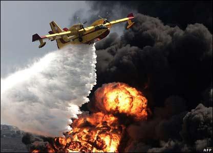


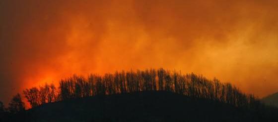
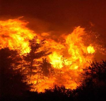

26 Real Time Fire Monitoring Activation in Greece Peloponnesus 2007 AliveriEuboea Fire Regional Real Time Fire Monitoring - NOA s MSG SEVIRI Station aharo Fire Olympia site Fire Korinthos Fire Stira Euboea Fire arnon Mt Fire Taygetos Mt Fire Megalopolis Fire Oitilon Fire POTENTIAL FIRE BEYOND KOM, 18/07/2013, Athens CONFIRMED FIRE


27 150 minutes after fire ignition
.")
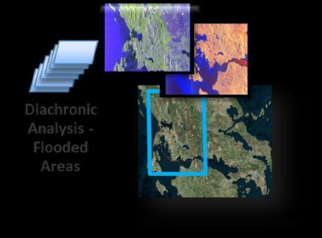
28 FloodHub: BEYOND s Floods Monitoring Service Detail We provide floods mapping and floods extent measuring. We have completed the processing and analysis for the first hydrological year with available Sentinel-1 images ( ). We are now working on the second hydrological year ( ).

29 Copernicus EMS Risk & Recovery Activations Bulgaria EMSN022 Flood

30 Copernicus EMS Risk & Recovery Activations Azores islands, Portugal EMSN018 Multiple natural hazards: Seismic Flash Flood Tsunami & Storm Surges Landslide & Erosion Lava Flow Coastal Erosion


![facilities) [A] Construction](/docs-images/76/74214412/images/31-9.jpg "of defences in order to")

31 Azores activation Tsunami-Storm Surges A B Major types of structural countermeasures: Structural reinforcement of assets (ports & other on land facilities) [A] Construction of defences in order to reduce tsunami & storm surges intrusion (Breakwaters, seawalls, groins, quays, dykes / levees) [B]

32 Earthquakes Cephalonia case 3D crustal deformation from TerraSAR-X & COSMO-SkyMed data Inversion to estimate fault parameters Merryman Boncori et al., SRL 2015

33 Earthquakes New Zeland EQ Mw=7,8, 13/11/2016 3D crustal deformation from Sentinel-1 data Inversion to estimate fault parameters

34 Volcanoes Santorini case Data NSN NOANET ENIGMA In-situ Services Geodesy Modeling Hazard Ass. Large Proc. Applications Tectonics Volcanoes Landslides Subsidence Jan Mar inflation episode Papoutsis et al., GRL 2013


 from LIVAS 4-year averages of")

35 Global 3D climatology of aerosols and clouds Based on 4-year CALIPSO observations Global 3D climatology of aerosols and clouds LIVAS portal under BEYOND (1x1 degree resolution) Global AOD at VIS (532 nm) from LIVAS 4-year averages of CALIPSO observations LIVAS AOD evaluation against AERONET
36

37 Copernicus EMS Risk & Recovery Activations Catalonia, Spain EMSN026 Toxic cloud after an industrial accident


38 Dust initial field assimilation U.K. Met Office MSG dust optical thickness NMME-DREAM model with dust assimilation Solomos et al., 2016, COMECAP


39 UAV Assisted Loss Recording Cephalonia Earthquake Feb 2014


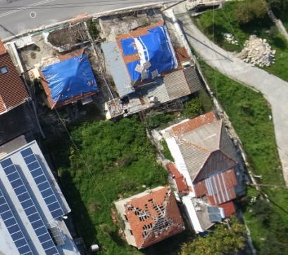
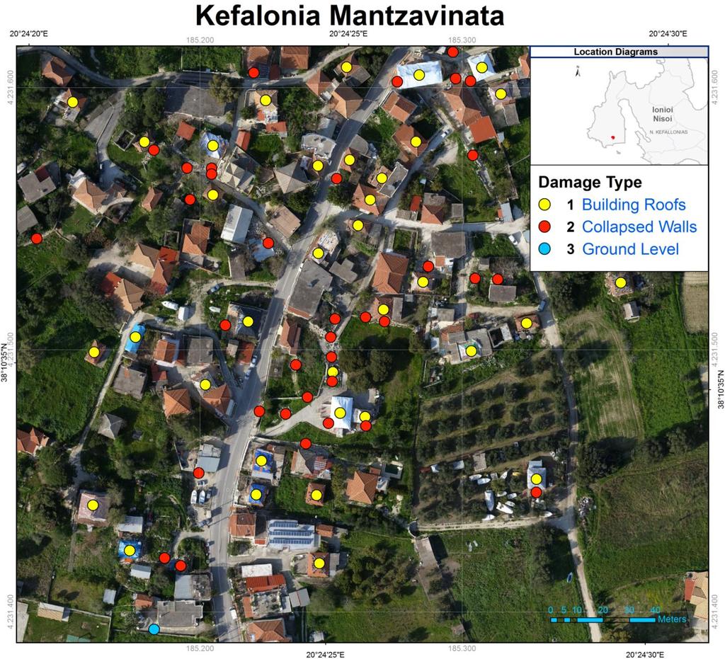
40 Cephalonia Island Village of Mantzavinata
41 Activation Thasos, Greece Fire


42 Activation Thasos, Greece Fire


43 Activation Thasos, Greece Fire


44 For more information
The BEYOND Center of Excellence for monitoring natural disasters from space
 The BEYOND Center of Excellence for monitoring natural disasters from space Ioannis Papoutsis National Observatory of Athens Institute for Astronomy, Astrophysics, Space Applications & Remote Sensing MOWE-IT
Copernicus EMS: Αξιολόγηση πολλαπλών φυσικών κινδύνων - Σχεδιασμός και Ανάκτηση
 Building Capacity for a Centre of Excellence for EO-based monitoring of Natural Disasters Copernicus EMS: Αξιολόγηση πολλαπλών φυσικών κινδύνων - Σχεδιασμός και Ανάκτηση Γιάννης Παπουτσής ΙΑΑΔΕΤ Εθνικό
GEO-CRADLE - μία πλατφόρμα συλλογής δεδομένων Παρατήρησης της Γης, στις περιοχές των Βαλκανίων, της Βορείου Αφρικής και της Μέσης Ανατολής
 GEO-CRADLE - μία πλατφόρμα συλλογής δεδομένων Παρατήρησης της Γης, στις περιοχές των Βαλκανίων, της Βορείου Αφρικής και της Μέσης Ανατολής Dr. Evangelos Gerasopoulos Director of the Greek GEO Office National
EuroGEOSS Protected Areas Pilot
 EuroGEOSS Protected Areas Pilot Max Craglia European Commission Joint Research Centre Part 1: the present MyNatura2000 Mobile app. Awareness raising & volunteered data collection. Natura2000 covers 18%
GMES EURORISK Geo-information services for natural and man-made risks management
 GMES EURORISK Geo-information services for natural and man-made risks management 8/11/2004 EURORISK A European scale approach for developing, delivering and operationally exploiting new information services
Copernicus Overview and Emergency Management Service
 Copernicus Overview and Emergency Management Service Frédéric BASTIDE European Commission Open informal session of the United Nations Inter-Agency Meeting on Outer Space Activities 12 March 2013, Geneva
Copernicus Today and Tomorrow GEO Week Group on Earth Observation Geneva, 16 January 2014 The Copernicus Space Infrastructure
 Copernicus Today and Tomorrow GEO Week Group on Earth Observation Geneva, 16 January 2014 The Copernicus Space Infrastructure Thomas Beer, Policy Coordinator, Copernicus Space Office, ESA-ESRIN, Frascati
C o p e r n i c u s a n d W I G O S
 C o p e r n i c u s a n d W I G O S Jean-Noël Thépaut & Mark Dowell 24 October 2017 GEO XIV, Washington DC, 23-28 October 2017 T h e C o p e r n i c u s P r o g r a m m e Copernicus is the European Union
Earth Observation and GEOSS in Horizon Copernicus for Raw Material Workshop 5 th September 2016
 Earth Observation and GEOSS in Horizon 2020 Copernicus for Raw Material Workshop 5 th September 2016 Gilles OLLIER Head of Sector -Earth observation Directorate Environment Unit I.4 Climate Actions and
EUMETSAT. A global operational satellite agency at the heart of Europe. Presentation for the Spanish Industry Day Madrid, 15 March 2012
 EUMETSAT A global operational satellite agency at the heart of Europe Presentation for the Spanish Industry Day Madrid, Angiolo Rolli EUMETSAT Director of Administration EUMETSAT objectives The primary
Alexia Tsouni National Observatory of Athens. Antwerp, 19/09/
 Coordinating and Integrating EO Activities in North Africa, Middle East, and Balkans. Accelerating the Development of Links with Geo/ Geoss/Copernicus and Inspire initiatives Alexia Tsouni National Observatory
GI Technology for Disaster Management
 GI Technology for Disaster Management 17 th ICC on the Regional Space Applications Programme for Sustainable Development (RESAP) 26 th Nov 2013 Bangkok Thailand Period and time of seasonal in thailand
GEO-VIII November Geohazard Supersites and Natural Laboratories Progress Report. Document 9
 GEO-VIII 16-17 November 2011 Geohazard Supersites and Natural Laboratories Progress Report Document 9 This document is submitted to GEO-VIII for information. Geohazard Supersites and Natural Laboratories
Norwegian spatial data infrastructure supporting disaster risk management Norwegian Mapping Authority
 Norwegian spatial data infrastructure supporting disaster risk management Norwegian Mapping Authority Arvid Lillethun, Norwegian Mapping Authority Land and Poverty 2018 Conference, World Bank 19.-23. March
Copernicus Overview. Major Emergency Management Conference Athlone 2017
 Copernicus Overview Major Emergency Management Conference Athlone 2017 Copernicus is a European programme implemented by the European Commission. The services address six thematic areas: land, marine,
UN COPUOS 52 nd session of the Scientific and Technical Subcommittee. COPERNICUS - an European Achievement. S. Jutz Head, ESA Copernicus Space Office
 UN COPUOS 52 nd session of the Scientific and Technical Subcommittee COPERNICUS - an European Achievement S. Jutz Head, ESA Copernicus Space Office 11 Feb 2015, Vienna 1 2 What is Copernicus? European
EU collaborations with NASA LCLUC Program & Current Priorities
 & Current Priorities ioannis Manakos, Dr. Centre for Research and Technology Hellas Information Technologies Institute Visual Analytics, Virtual & Augmented Reality Laboratory European Association of Remote
Introduction of the Asia-Oceania Global Earth Observation System of Systems (AOGEOSS) GEO Initiative(GI-22 )
 GEO Initiative(GI-22 )") Introduction of the Asia-Oceania Global Earth Observation System of Systems (AOGEOSS) GEO Initiative(GI-22 ) Prof. Xiang ZHOU Institute of Remote Sensing and Digital Earth, CAS 11 May 2017 Kunming, China
Introduction of the Asia-Oceania Global Earth Observation System of Systems (AOGEOSS) GEO Initiative(GI-22 ) Prof. Xiang ZHOU Institute of Remote Sensing and Digital Earth, CAS 11 May 2017 Kunming, China
Copernicus Information & Training Session
 Copernicus Information & Training Session Copernicus Emergency Management Service Dora Aifantopoulou GEOAPIKONISIS S.A.P.GE. Copernicus EU Copernicus EU Copernicus EU www.copernicus.eu Athens 07.10.2016
Supporting GPSC Cities with Satellite Earth Observation for Sustainable Urban Development
 Supporting GPSC Cities with Satellite Earth Observation for Sustainable Urban Development Global Platform for Sustainable Cities African Regional Workshop 14 May 2018 AfDB Headquarters Abidjan, Côte d'ivoire
Space research. Horizon Work Programme. "Countdown to Horizon 2020 Space" Earth Observation topics. Brussels, 12 December 2013
 Space research Horizon 2020 - Work Programme "Countdown to Horizon 2020 Space" Earth Observation topics Brussels, 12 December 2013 richard.gilmore@ec.europa.eu Table of contents FP/Copernicus - general
Emergency Management Service (EMS) mapping
 mapping") GMES Emergency Management Service (EMS) mapping Frédéric BASTIDE GMES unit, European Commission UN-SPIDER Expert Meeting: "Crowdsource Mapping for Disaster Risk Management and Emergency Response" 3-5 December,
GMES Emergency Management Service (EMS) mapping Frédéric BASTIDE GMES unit, European Commission UN-SPIDER Expert Meeting: "Crowdsource Mapping for Disaster Risk Management and Emergency Response" 3-5 December,
Cristina Ananasso Copernicus Unit DG GROW. H2020 Space: Calls on Earth Observation and Copernicus Ilan Ramon Conference 28/01/2018 Tel Aviv
 Cristina Ananasso Copernicus Unit DG GROW H2020 Space: Calls on Earth Observation and Copernicus Ilan Ramon Conference 28/01/2018 Tel Aviv OUTLINE Call Space 2018-2020 - Earth Observation and Copernicus
The Santorini Inflation Episode, Monitored by InSAR and GPS
 The Santorini Inflation Episode, Monitored by InSAR and GPS Ioannis Papoutsis 1,2, Xanthos Papanikolaou 2, Michael Floyd 3, Kang Hyeun Ji 4, Charalampos Kontoes 1, Demitris Paradissis 2, Demitris Anastasiou
Global Monitoring for Environment and Security (GMES)
") Global Monitoring for Environment and Security (GMES) Satellite Earth Observation for the Emergency Services Dr Nick Veck Presentation to the G-STEP Launch Univ. of Leicester 19 th June 2009 Contents of
Global Monitoring for Environment and Security (GMES) Satellite Earth Observation for the Emergency Services Dr Nick Veck Presentation to the G-STEP Launch Univ. of Leicester 19 th June 2009 Contents of
Pilot applications for Greece and Egypt related end-users
 GEO-CRADLE Project Meeting 2 16 th November, 2016 Pilot applications for Greece and Egypt related end-users Panagiotis Kosmopoulos & Hesham El-Askary National Observatory of Athens Chapman University Eratosthenes
U s i n g t h e E S A / E U M E T C A S T N a v i g a t o r s
 U s i n g t h e E S A / E U M E T C A S T N a v i g a t o r s Copernicus User Uptake Information Sessions Copernicus EU Copernicus EU Copernicus EU www.copernicus.eu I N T R O D U C T I O N O F U S E C
Geographic Information Infrastructure and Policy Framework for Sustainable Mountain Development in the Hindu Kush-Himalayas
 Geo SMART ASIA 2017 22-24 August, Kualalampur Geographic Information Infrastructure and Policy Framework for Sustainable Mountain Development in the Hindu Kush-Himalayas Basanta Shrestha, Director Strategic
NWC-SAF Satellite Application Facility in Support to Nowcasting and Very Short Range Forecasting
 NWC-SAF Satellite Application Facility in Support to Nowcasting and Very Short Range Forecasting Marianne König Slide 1 Satellite Application Facilities (SAFs) in Europe Member State Cooperating State
The ESA Earth observation programmes overview and outlook
 The ESA Earth observation programmes overview and outlook Dr. Volker Liebig Director, ESA EO Programmes ILA 2008, Berlin ENVISAT mission: 6 years! Bam earthquake Tectonic uplift (Andaman) Arctic 2007 First
Status of EUMETSAT Operational Services & EUMETCast Africa Dissemination Baseline Updates
 Status of EUMETSAT Operational Services & EUMETCast Africa Dissemination Baseline Updates Sally Wannop User Relations Manager 1 8th WMO RAIDEG meeting 1-2 November 2017 # 951881 Overview EUMETCast Overview
The importance of satellite data and products for RA1 in the WWRP strategy. Estelle de Coning World Weather Research Division
 The importance of satellite data and products for RA1 in the WWRP strategy Estelle de Coning World Weather Research Division Kofi Annan former UN Secretary-General (21 July 2016) "The poor need alerts
The National Observatory of Athens: Research, Specialized Services and its operational role!
 The National Observatory of Athens: Research, Specialized Services and its operational role! 53d European Space Sciences Committee Plenary Meeting, Athens 1-2 June 2017, Academy of Athens National Observatory
EUMETSAT SAF NETWORK. Lothar Schüller, EUMETSAT SAF Network Manager
 1 EUMETSAT SAF NETWORK Lothar Schüller, EUMETSAT SAF Network Manager EUMETSAT ground segment overview METEOSAT JASON-2 INITIAL JOINT POLAR SYSTEM METOP NOAA SATELLITES CONTROL AND DATA ACQUISITION FLIGHT
Collaborative Systems for the Creation of Marine Services
 Collaborative Systems for the Creation of Marine Services INSPIRE 2016 Nuno Almeida Nuno Catarino Barcelona, 28 th September 2016 Elecnor Deimos is a trademark which encompasses Elecnor Group companies
Space Weather & Critical Infrastructures
 Space Weather & Critical Infrastructures Italy Organisers EC JRC, MSB, UK Met Office Date and Venue 29-30 November 2016, JRC Ispra, Background Our modern technological infrastructures on the ground and
National Satellite Data Centre and Finnish Sentinel Collaborative Ground Segment. Jyri Heilimo Finnish Meteorological Instute
 National Satellite Data Centre and Finnish Sentinel Collaborative Ground Segment Jyri Heilimo Finnish Meteorological Instute Sodankylä National Satellite Data Centre National satellite data centre providing
Liana Talaue McManus. Division of Marine Affairs and Policy Rosenstiel School of Marine & Atmospheric Science University of Miami
 Liana Talaue McManus Division of Marine Affairs and Policy Rosenstiel School of Marine & Atmospheric Science University of Miami Outline 1. Coasts as vulnerable & resilient social ecological systems 2.
Applied Geoscience and Technology Division SOPAC. Joy Papao, Risk Information Systems Officer
 Joy Papao, Risk Information Systems Officer Secretariat of the Pacific Community SPC 22 Pacific Island States Head office in Noumea, New Caledonia 2 Regional offices (Pohnpei and Honiara) 600 staff 9 Technical
EO Information Services. Assessing Vulnerability in the metropolitan area of Rio de Janeiro (Floods & Landslides) Project
 Project") EO Information Services in support of Assessing Vulnerability in the metropolitan area of Rio de Janeiro (Floods & Landslides) Project Ricardo Armas, Critical Software SA Haris Kontoes, ISARS NOA World
EO Information Services in support of Assessing Vulnerability in the metropolitan area of Rio de Janeiro (Floods & Landslides) Project Ricardo Armas, Critical Software SA Haris Kontoes, ISARS NOA World
Earth Observations as a Tool To Achieve Sustainable Development Goals
 The image part with relationship ID rid3 was not found in the file. 16/10/2017 Earth Observations as a Tool To Achieve Sustainable Development Goals LI Jing, China GEO On behalf of the Group on Earth Observations
The CEOS Atmospheric Composition Constellation (ACC) An Example of an Integrated Earth Observing System for GEOSS
 An Example of an Integrated Earth Observing System for GEOSS") The CEOS Atmospheric Composition Constellation (ACC) An Example of an Integrated Earth Observing System for GEOSS Presentation Authors: E. Hilsenrath NASA, C. Zehner ESA, J. Langen ESA, J. Fishman NASA
The CEOS Atmospheric Composition Constellation (ACC) An Example of an Integrated Earth Observing System for GEOSS Presentation Authors: E. Hilsenrath NASA, C. Zehner ESA, J. Langen ESA, J. Fishman NASA
The International Charter Space and Major Disasters is further strengthening its contribution to disaster management worldwide.
 28 September 2012 Issue 3 The International Charter Space and Major Disasters is further strengthening its contribution to disaster management worldwide. Building on a decade of success in making satellite
ESA Climate Change Initiative (CCI)
") ESA Climate Change Initiative (CCI) New ESA Programme with the aim to contribute to worldwide efforts to generate Essential Climate Variables (ECVs) C. Zehner Barcelona, 07/09/2009 Two climate action paths
ESA Climate Change Initiative (CCI) New ESA Programme with the aim to contribute to worldwide efforts to generate Essential Climate Variables (ECVs) C. Zehner Barcelona, 07/09/2009 Two climate action paths
Building Institutional Capacity for Multi-Hazard Early Warning in Asia and the Pacific Subtitle
 Building Institutional Capacity for Multi-Hazard Early Warning in Asia and the Pacific Subtitle Title Keran Wang Chief, Space Applications Section ICT and Disaster Risk Reduction Division 22 May 2018 Pillar
A state of the art and user driven Copernicus service Physics and Biogeochemistry
 C M E M S P r e s e n t a n d F u t u r e R e q u i r e m e n t s f o r I n - S i t u a n d S a t e l l i t e O b s e r v a t i o n s Antonio REPPUCCI; Pierre Yves LE TRAON Mercator Ocean International
GEO Coastal Zone Community of Practice (CZCP)
") ! "#$%&" $'( )$*+,-.'// Global, regional and local trends in natural processes and human demands on coastal ecosystems jeopardize the ability of these ecosystems to support commerce, living resources,
! "#$%&" $'( )$*+,-.'// Global, regional and local trends in natural processes and human demands on coastal ecosystems jeopardize the ability of these ecosystems to support commerce, living resources,
sentinel-2 COLOUR VISION FOR COPERNICUS
 sentinel-2 COLOUR VISION FOR COPERNICUS SATELLITES TO SERVE By providing a set of key information services for a wide range of practical applications, Europe s Copernicus programme is providing a step
WMO Global Data-Processing and Forecasting System Operational weather forecast product delivery relevant to SDSWS
 WMO Global Data-Processing and Forecasting System Operational weather forecast product delivery relevant to SDSWS Peter Chen World Weather Watch Department, WMO WMO/GEO Expert Meeting for an International
Copernicus Schaffung einer europäischen Kapazität für die operationelle Erdbeobachtung
 Copernicus Schaffung einer europäischen Kapazität für die operationelle Erdbeobachtung ESOC, Darmstadt, 23 April 2015 Simon Jutz, ESA Head, Copernicus Space Office (EOP-CO) Earth Observation Programmes
An Eye in the Sky EUMETSAT. Monitoring Weather, Climate and the Environment
 An Eye in the Sky EUMETSAT Monitoring Weather, Climate and the Environment Slide: 1 Hazardous Weather Slide: 2 Hazardous Weather Slide: 3 Natural Disasters set off by severe weather Slide: 4 EUMETSAT Objectives...
The Joint Programming Initiative on Cultural Heritage (JPICH): European perspective
: European perspective") COPERNICUS FOR CULTURAL HERITAGE Copernicus User Forum Industry Workshop Brussels, 24 April 2017 The Joint Programming Initiative on Cultural Heritage (JPICH): European perspective Cristina Sabbioni CNR,
COPERNICUS FOR CULTURAL HERITAGE Copernicus User Forum Industry Workshop Brussels, 24 April 2017 The Joint Programming Initiative on Cultural Heritage (JPICH): European perspective Cristina Sabbioni CNR,
EuroGEOSS for Drought - Linking the European Drought Observatory to global and local scales
 EuroGEOSS for Drought - Linking the European Drought Observatory to global and local scales Barbara Hofer, Stefan Niemeyer, EC-JRC INSPIRE Conference 2010 Cracow June 24, 2010 Drought Relevance Droughts
Georeferencing and Satellite Image Support: Lessons learned, Challenges and Opportunities
 Georeferencing and Satellite Image Support: Lessons learned, Challenges and Opportunities Shirish Ravan shirish.ravan@unoosa.org UN-SPIDER United Nations Office for Outer Space Affairs (UNOOSA) UN-SPIDER
National Remote Sensing Center of China. Space Technology for Sustainable Development in China Status, Achievements and Futures.
 National Remote Sensing Center of China Space Technology for Sustainable Development in China Status, Achievements and Futures Jing Li National Remote Sensing Center of China Ministry of Science and Technology,
Current and Upcoming NASA Hurricane Measurement Missions National Hurricane Conference
 NASA Science Mission Directorate Earth Science Division Applied Sciences Program Current and Upcoming NASA Hurricane Measurement Missions National Hurricane Conference April 18, 2017 Formulation Implementation
Publishable Summary. Summary Description of the project context and main objectives
 Publishable Summary Summary Description of the project context and main objectives Tsunamis are low frequency but high impact natural disasters. In 2004, the Boxing Day tsunami killed hundreds of thousands
UN GGIM and National SDI Strategy
 MSDI Open Forum on 26 th January 2016 Contributing to the successful delivery of MSDI UN GGIM and National SDI Strategy Hiroshi Murakami Deputy Administrator Geospatial Information Authority of Japan Geospatial
IGOS Geohazards: toward an improved use of Earth Observations for Geohazards mitigation
 IGOS Geohazards: toward an improved use of Earth Observations for Geohazards mitigation Scientific and Technical Subcommittee session Vienna, 15th February 2007 Gonéri Le Cozannet IGOS Geohazards Bureau
EARLY WARNING SYSTEM AND THE ROLE OF METEOROLOGICAL AND HYDROLOGICAL SERVICE CROATIA
 EARLY WARNING SYSTEM AND THE ROLE OF METEOROLOGICAL AND HYDROLOGICAL SERVICE CROATIA Meteorological and Hydrological Service National Protection and Rescue Directorate B. Ivančan an-picek V. Stajčić Establishment
MONITORING THE ATMOSPHERE, OCEAN AND CLIMATE FROM SPACE
 MONITORING THE ATMOSPHERE, OCEAN AND CLIMATE FROM SPACE TRANSFORMING OUR WORLD MONITORING WEATHER AND CLIMATE FROM SPACE MONITORING THE ATMOSPHERE, OCEAN AND CLIMATE FROM SPACE FOR TRANSFORMING OUR WORLD
Geohazard Supersites and Natural Laboratories
 Geohazard Supersites and Natural Laboratories FRINGE 2011, Frascati, Italy, September 19, 2011 Wolfgang Lengert, ESA Falk Amelung, University of Miami, GEO task lead Craig Dobson, NASA, CEOS task lead
Compact guides GISCO. Geographic information system of the Commission
 Compact guides GISCO Geographic information system of the Commission What is GISCO? GISCO, the Geographic Information System of the COmmission, is a permanent service of Eurostat that fulfils the requirements
The GMES/MyOcean Marine Service and its applications
 The GMES/MyOcean Marine Service and its applications P.Y. Le Traon (Ifremer) P. Bahurel (Mercator Ocean) First BreTel Workshop May 31st, 2012 - St Malo Outline The GMES Marine Service and MyOcean What
Meteorological instruments and observations methods: a key component of the Global Earth Observing System of Systems (GEOSS)
") GLOBAL OBSERVING SYSTEMS Instruments and Methods of Observation Programme Meteorological instruments and observations methods: a key component of the Global Earth Observing System of Systems (GEOSS) Dr.
GLOBAL OBSERVING SYSTEMS Instruments and Methods of Observation Programme Meteorological instruments and observations methods: a key component of the Global Earth Observing System of Systems (GEOSS) Dr.
European Space Agency
 Guidelines - Guidelines how/when to interact during the WebEx session: - Due to the number of attendees, please keep always your webcam and microphone switched-off - You can use anytime the chat to all
GEO Geohazards Community of Practice
 GEO Geohazards Community of Practice 1) Co-Chair of GHCP With input from: Stuart Marsh, GHCP Co-Chair Francesco Gaetani, GEO Secretariat and many GHCP contributors 1) Nevada Bureau of Mines and Geology
Use of climate reanalysis for EEA climate change assessment. Blaz Kurnik. European Environment Agency (EEA)
") Use of climate reanalysis for EEA climate change assessment Blaz Kurnik European Environment Agency (EEA) 2016: EEA content priorities Circular economy Climate and Energy Sustainable Development Goals
Use of climate reanalysis for EEA climate change assessment Blaz Kurnik European Environment Agency (EEA) 2016: EEA content priorities Circular economy Climate and Energy Sustainable Development Goals
JICA s Experiences of Connecting Japanese Science & Technologies for Disaster Risk Reduction in Developing Countries
 JICA s Experiences of Connecting Japanese Science & Technologies for Disaster Risk Reduction in Developing Countries Junji WAKUI Deputy Director General, Group Leader Disaster Risk Reduction Group Global
Observation (EO) & Geomatics in Canada
 & Geomatics in Canada") Innovating to Increase the Impact of Earth Observation (EO) & Geomatics in Canada Natural Resources Canada February 25, 2014 Prashant Shukle, Director General Canada Centre for Mapping and Earth Observation
Innovating to Increase the Impact of Earth Observation (EO) & Geomatics in Canada Natural Resources Canada February 25, 2014 Prashant Shukle, Director General Canada Centre for Mapping and Earth Observation
Status of EUMETSAT Current and Future Programmes
 Status of EUMETSAT Current and Future Programmes Ernst Koenemann Director Programme Development Spanish Industry Day 15 th Slide: 1 Brief Status of MSG and EPS All operational Missions are performing as
Advancing Geoscientific Capability. Geological Survey of Finland
 Advancing Geoscientific Capability Geological Survey of Finland GTK in brief The Geological Survey of Finland (GTK) is one of the largest European centres of excellence in assessment, research and the
Securing EUMETSAT s Mission from an Evolving Space Environment
 Securing EUMETSAT s Mission from an Evolving Space Environment ESPI 12 th Autumn Conference Andrew Monham 1 EUMETSAT: Intergovernmental Organisation of 30 Member States Presentation Contents AUSTRIA BELGIU
Geological information for Europe : Towards a pan-european Geological Data Infrastructure
 Geological information for Europe : Towards a pan-european Geological Data Infrastructure Integrating geoscientific information for EU competitiveness Co-funded by the European Union European societal
A BRIEF INTRODUCTION TO COPERNICUS AND CAMS
 A BRIEF INTRODUCTION TO COPERNICUS AND CAMS Juan Garcés de Marcilla Director of Copernicus Services European Centre for Medium-Range Weather Forecasts Copernicus EU Copernicus EU Copernicus EU www.copernicus.eu
Group on Earth Observations (GEO) Cold Regions Work Plan Item WA-01-C3
 Cold Regions Work Plan Item WA-01-C3") EC Panel of Experts on Polar Observations, Research and Services Group on Earth Observations (GEO) Cold Regions Work Plan Item WA-01-C3 Barbara J. Ryan Secretariat Director Lanzhou, China 13 March 2013
EC Panel of Experts on Polar Observations, Research and Services Group on Earth Observations (GEO) Cold Regions Work Plan Item WA-01-C3 Barbara J. Ryan Secretariat Director Lanzhou, China 13 March 2013
WWRP Implementation Plan Reporting
 WWRP Implementation Plan Reporting This report will form the basis of the WWRP report to the upcoming session of the WMO Commission for Atmospheric Sciences. As you respond to this request please think
Maryland Space. Business Roundtable. Satellite and Information Service. Stephen Volz, Ph.D., Assistant Administrator. January 2018
 Maryland Space Satellite and Information Service Business Roundtable Stephen Volz, Ph.D., Assistant Administrator January 2018 Delivering on the Commitment JPSS-1 Launch Nov 18, 2017 GOES-R Launch Nov
The Copernicus Sentinel-5 Mission: Daily Global Data for Air Quality, Climate and Stratospheric Ozone Applications
 SENTINEL-5 The Copernicus Sentinel-5 Mission: Daily Global Data for Air Quality, Climate and Stratospheric Ozone Applications Yasjka Meijer RHEA for ESA, Noordwijk, NL 15/04/2016 Co-Authors: Jörg Langen,
Research Programme Polar, Marine and Coastal Systems. Current and future Arctic research priorities of Germany Nicole Biebow, AWI
 Research Programme Polar, Marine and Coastal Systems Current and future Arctic research priorities of Germany Nicole Biebow, AWI Arctic Science and Technology (S&T) Collaboration and Engagement Workshop,
GEO-CRADLE Project Meeting 2 Thursday, 17 th November, 2016
 GEO-CRADLE Project Meeting 2 Thursday, 17 th November, 2016 T4.3 EGS-PGI NRI Marek Graniczny (EGS PGI) Maria Przyłucka (EGS PGI) Eleftheria Poyiadji (EGS-IGME-Greece) Zbigniew Kowalski (EGS PGI) Christodoulos
Geodesy. orientation. shape. gravity field
 Geodesy noun Science of measuring the shape, orientation and gravity field of the Earth and how it changes over time. shape orientation gravity field Positioning has always been important Downstream applications
FINDINGS OF THE ARCTIC METEOROLOGY SUMMIT
 FINDINGS OF THE ARCTIC METEOROLOGY SUMMIT 2018 WWW.FMI.FI CHAIR S SUMMARY: 1 2 3 We need to be curious to explore the known unknowns. Meteorology is an elemental part of international collaboration in
OSS MISSION.
 GEO-CRADLE COORDINATING AND INTEGRATING STATE-OF-THE-ART EARTH OBSERVATION ACTIVITIES IN THE REGION OF NORTH OF AFRICA, MIDDLE EAST, AND BALKANS AND DEVELOPING LINKS WITH GEO RELATED INITIATIVES TOWARD
EUMETSAT Training activities. Vesa Nietosvaara Mark Higgins
 EUMETSAT Training activities Vesa Nietosvaara Mark Higgins EUMETSAT Partnerships Europe: SAFs and regional networks EUMeTrain training recourses and tools Eumetcal coordination and infrastructure Africa:
Disaster Management & Recovery Framework: The Surveyors Response
 Disaster Management & Recovery Framework: The Surveyors Response Greg Scott Inter-Regional Advisor Global Geospatial Information Management United Nations Statistics Division Department of Economic and
The UN-GGIM: Europe core data initiative to encourage Geographic information supporting Sustainable Development Goals Dominique Laurent, France
 INSPIRE conference Strasbourg 6 September 2017 The UN-GGIM: Europe core data initiative to encourage Geographic information supporting Sustainable Development Goals Dominique Laurent, France Introduction
WMO SDS-WAS. Observational needs. Enric Terradellas, AEMET, Barcelona chair of the WMO SDS-WAS Steering Committtee
 WMO SDS-WAS Observational needs Enric Terradellas, AEMET, Barcelona eterradellasj@aemet.es chair of the WMO SDS-WAS Steering Committtee GAW Symposium, Geneva, Switzerland, 10-13 April 2017 WMO SDS-WAS
Osservazione della terra da piattaforme remore ed in-situ fisse e mobili. Massimo Caccia CNR - ISSIA
 Osservazione della terra da piattaforme remore ed in-situ fisse e mobili Massimo Caccia CNR - ISSIA massimo.caccia@ge.issia.cnr.it 1 Research themes geo-physical monitoring environmental hazards monitoring
CEOS WG Disasters Report
 Committee on Earth Observation Satellites CEOS WG Disasters Report Stéphane Chalifoux SIT Tech Workshop 2016 Agenda Item # 16 CEOS Strategic Implementation Team Tech Workshop Oxford, UK 14 th -15 th September
METEOSAT THIRD GENERATION
 METEOSAT THIRD GENERATION FACTS AND FIGURES MONITORING WEATHER AND CLIMATE FROM SPACE A HIGHLY INNOVATIVE GEOSTATIONARY SATELLITE SYSTEM FOR EUROPE AND AFRICA The Meteosat Third Generation (MTG) system
ADVANTAGES OF GIS-INTEGRATED MARITIME DATA IN THE BLACK SEA REGION FOR MULTIPURPOSE USE
 INTERAGENCY INTERACTION IN CRISIS MANAGEMENT AND DISASTER RESPONSE 2017 ADVANTAGES OF GIS-INTEGRATED MARITIME DATA IN THE BLACK SEA REGION FOR MULTIPURPOSE USE Lyubka Pashova 1, Anna Kortcheva 2, Vasko
Use of geo-referenced data for DRM in Central Asia, problems and prospective
 Use of geo-referenced data for DRM in Central Asia, problems and prospective Dr. Akylbek Chymyrov Director, Kyrgyz Center of Geoinformation Systems Member of the Public Supervisory Board MES KR KSUCTA,
Introduction of Remote Sensing Methods for Monitoring the Under Restoration Amiantos Mine, Cyprus
 Sixth International Conference on Remote Sensing and Geoinformation of Environment, 26-29 March, 2018 - Cyprus Introduction of Remote Sensing Methods for Monitoring the Under Restoration Amiantos Mine,
Space technologies for meteorological extreme events forecast and monitoring in Romania
 Space technologies for meteorological extreme events forecast and monitoring in Romania Dr. Ion SANDU Dr. Gheorghe STANCALIE National Meteorological Administration Bucharest, Romania Contents: Introduction
Geohazard Supersites and Natural Laboratories
 Geohazard Supersites and Natural Laboratories FRINGE 2011, Frascati, Italy, September 19, 2011 Wolfgang Lengert, ESA Falk Amelung, University of Miami, GEO task lead Craig Dobson, NASA, CEOS task lead
Network of European Regions Using Space Technologies
 NEREUS Network of European Regions Using Space Technologies Core mission NEREUS WHAT IS SPACE ABOUT??? Spreading use of space technologies at regional level Stimulating the development of space applications
Egypt-NOAA Cooperation: Advancing our Environmental Science, Technology, and Education
 Egypt-NOAA Cooperation: Advancing our Environmental Science, Technology, and Education T. G. Onsager NOAA Space Weather Prediction Center and NWS International Activities Office (one-year detail) Terry.Onsager@noaa.gov
Sentinel-1 Mission Status
 Sentinel-1 Mission Status Pierre Potin, Sentinel-1 Mission Manager, ESA Luca Martino, Technical Support Engineer, ESA... and the Sentinel-1 operations team PSTG SAR Coordination Working Group 14 December
The Spatial Information Corridor Contributes to UNISPACE+50. JIANG HUI Director of Internation Cooperation Department
 The Spatial Information Corridor Contributes to UNISPACE+50 JIANG HUI Director of Internation Cooperation Department 01 02 03 What is Belt & Road Spatial Information Corridor? China put forward the "Belt