Last Class. Syllabus. Archaeological Dating Methods. Introduction to the Earliest Americans
|
|
|
- Jasper Julius Cole
- 6 years ago
- Views:
Transcription

1 Last Class Syllabus Archaeological Dating Methods Introduction to the Earliest Americans Image retrieved from:
2 Today s Class Models of Migration Pre-Clovis Sites Introducing the Clovis Culture Image retrieved from:

3 Native American Cosmology - In-Situ Model - Encoded in oral tradition and ceremony - Vary from group to group Image retrieved from:

4 Early European Ideas - Origin explanations centered around the Bible - Pope determines native people of the New World were people - Early Origin Ideas - Lost Tribes of Israel - Lost Continents - Migration Image retrieved from:

5 Archaeological Migration Theories - Beringia and the Ice Free Corridor - Coastal Migration - Solutrean Hypothesis Image retrieved from:

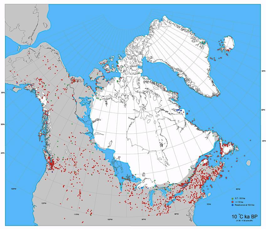
6 Interior Route - Last major sea level drop ~25,000 BP - Exposed Beringia until ~11,000 BP - Climate colder and drier than today - Cold adapted climates in northeastern Asia by 15,000 BP - No trees until ~14,000 BP - Glaciers in eastern Alaska Image retrieved from:

7 Image retrieved from:

8


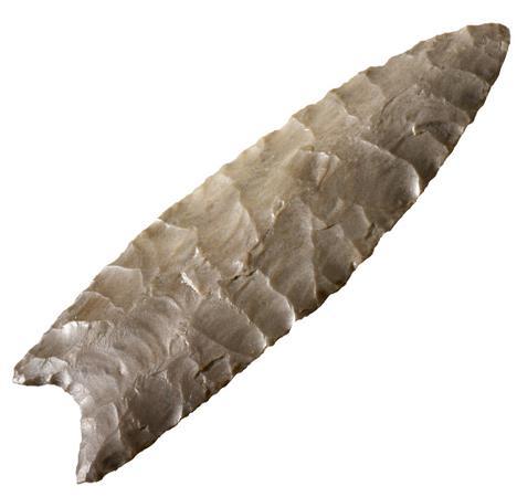
9 Clovis First Hypothesis - Most widespread Paleoindian culture - Type site is in New Mexico - Sites date between 11,500-10,900 rcybp - Diagnostic artifact is the Clovis Point Image retrieved from: umans_origins_of_clovis_people_sf_still_624x352.jpg - Unique fluting technology - Frequently associated with mammoth and mastodon remains - Found throughout North America Image retrieved from:

10 Image retrieved from:


11 Image retrieved from: Image retrieved from: tc.pbs.org/wgbh/nova/assets/img/ancient-clovis-cache/image-01- large.jpg Image retrieved from:

12 Image retrieved from: d.jpg

13 Image retrieved from: ontinent_647kb.jpg

14 Pre-Clovis - Refers to sites that date before the earliest generally accepted age of Clovis (~12,500 BP) - Occupations took place when Ice Free Corridor was unavailable - Several sites in North America dated to between 20,000-13,000 BP - Several sites in South America date from earlier than 12,000 BP Image retrieved from:

15 Image retrieved from:

16 Schaefer and Hebior Kill Sites (Wisconsin) Schaefer Mammoth Discovered in 1964 Cut Marks noticed on bones while in the museum Relocated in % of a mammoth recovered V Shaped cutmarks Fragments of two stone blades Dates to ~14,500 BP Image retrieved from: Hebior Mammoth Discovered in 1994 Located ¾ of a mile from Schaefer Mammoth 90% of a butchered mammoth More butchering tools Dated to years before Schaefer mammoth

17 Manis Mastodon Site, Washington Located in 1977 Rib bone with what appeared to be a spear point Point made from the bone of a different mastodon Bone growth suggests mastodon did not die from point Suggests earliest evidence of humans hunting in the region Dated to 13,800 BP Image retrieved from:


18 Image retrieved from: Image retrieved from:


19 Meadowcroft Rockshelter Located in Pennsylvania Image retrieved from: 14/08/rockshelf-shelter.jpg Excavations began in 1973 Dated to ~16,000 BP and possibly as early as ~19,000 BP Dates controversial due to carbon contamination from coal bearing strata Remains of over 149 species of animals Evidence of fauna gathering including corn, squash, fruits, nuts, and seeds Miller Laneolate projectile point recovered from site Image retrieved from:

20 Image retrieved from:

21 Cactus Hill Virginia Located on a sand hill consisting of wind deposited sand and silt Testing began in 1988 Artifacts recovered included blade like flakes and two reworked points Site was dated to between ~15,000- ~18,000 BP Integrity of the site is questioned due to its location on a sand dune. Image retrieved from:


22 Image retrieved from: Image retrieved from: Image retrieved from:


23 Image retrieved from: 186Microblades_360605_3.jpg Image retrieved from: s/bone%20implements/100_ x640.jpg.html Image retrieved from: hindadnpointcasthand.jpg Image retrieved from: on_microlitos.png/150px-arp%c3%b3n_con_microlitos.png

24 Image retrieved from: Image retrieved from:

25 Buttermilk Creek / Friedkin Site, Texas First identified in the 1920 s Excavations began in 1990s Very large Clovis component Located ~1 m below Clovis, Pre-Clovis Level Dated to between 16,700-13,200 BP Over 100 Stone tools, 160,000 pieces of debitage Pile of limestone rocks with four teeth from a young adult female Image retrieved from:


26


27 Parsons Island Maryland Four lithic artifacts recovered 225 cm below surface Dated to 17,133+/ C BP Four artifacts recovered including two bipoint bifaces and two utilized blades Image retrieved from: Over 40 additional artifacts found since 2013 Image retrieved from:

28 Retrieved from: m/doi/full/ / Figure 16 Examples of artifacts found at the Parson's Island site: A: Bipoint biface, Cretaceous Magothy Formation quartzite; B: Bipoint biface, quartzite; C: Bipoint biface, chert (found in situ); D: Bipoint biface, meta-rhyolite (patinated); E: Small lanceolate, chalcedony (with rounded cobble cortex); F: Small lanceolate, quartz; G: Small End scraper, jasper (made on a true blade); H: Utilized Flake, quartz; I: Utilized Flake,quartzite; J: Utilized Flake quartz; K: Shouldered Uniface, chert; L: Shouldered Uniface, chalcedony; M: Utilized Blade, cobble chert (note cortex). Note: Specimen C was found in situ within the 4Ab1 paleosol (see Figure 14B). Charcoal collected above this in-situ biface produced an age estimate of 17,133 ± 88 14C yr BP or 20,525 ± 341 cal yr BP. Published in: Jonathan C. Lothrop; Darrin L. Lowery; Arthur E. Spiess; Christopher J. Ellis; PaleoAmerica 2016, 2, DOI: / Copyright 2016 The Author(s) Figure 16 Examples of artifacts found at the Parson's Island site: A: Bipoint biface, Cretaceous Magothy Formation quartzite; B: Bipoint biface, quartzite; C: Bipoint biface, chert (found in situ); D: Bipoint biface, meta-rhyolite (patinated); E: Small lanceolate, chalcedony (with rounded cobble cortex); F: Small lanceolate, quartz; G: Small End scraper, jasper (made on a true blade); H: Utilized Flake, quartz; I: Utilized Flake,quartzite; J: Utilized Flake quartz; K: Shouldered Uniface, chert; L: Shouldered Uniface, chalcedony; M: Utilized Blade, cobble chert (note cortex). Note: Specimen C was found in situ within the 4Ab1 paleosol (see Figure 14B). Charcoal collected above this in-situ biface produced an age estimate of 17,133 ± 88 14C yr BP or 20,525 ± 341 cal yr BP

29 Page Ladson, Florida Dated to ~14,550 cal BP Submerged under 9 m of water along the Aucilla River First investigated from Initial excavations found stone artifacts with butchered mastodon remains Returned in Recovered six stone artifacts in deposits with remains of mastodon, camelid, and bison Image retrieved from:


30 Image retrieved from: Image retrieved from: Image retrieved from: dfront.net/content/advances/ 2/5/e /F2.large.jpg

31 Vero Man, Florida Human remains found in association with Pleistocene animal remains in 1915 and 1916 Engraved mammoth tusk found nearby Set of human remains is the largest from any Pleistocene age site in North America 2014 excavations reported a possible human living surface at least 12,000 years old excavations recovered burned bones from a dire wolf and a horse in a possible hearth Image retrieved from:

32 Paisley Caves, Oregon First Studied in 1930s University of Oregon returned in 2002 Dated to 14,500 BP Evidence of baskets and rope Plant Fibers and wooden artifacts Bones of Pleistocene camel, horse, bison, and waterfowl Bone Pit with remains of camel, horse, mountain sheep, waterfowl, and fish bones covered by stone slab Image retrieved from:

33 Image retrieved from:


34 Image retrieved from: Image retrieved from:
 of water Depressions may indicate occupation areas Image")
35 Haida Gwaii Formerly known as the Queen Charlotte Islands Archipelago on the North Coast of British Columbia. Researchers used underwater vehicles to probe ocean Potential fishing weir on the bottom of Juan Perez Sound under 122 meters (~400 ft) of water Depressions may indicate occupation areas Image retrieved from: 2%25255B2%25255D.jpg?imgmax=800 Oldest artifact in Canada came from the area, dated to 12,700 BP

36 A Coastal Route Coast was free of glacial ice as early as 17,000 BP Australia Colonized as early as 50,000 BP Maritime foodways practiced by the Jomon in southern Japan by 15,500 BP Sea levels currently much higher than they were at the Last Glacial Maximum Sites along the coastline are inundated by rising sea levels

37

38
39

40
41


42

43 SOLUTREAN HYPOTHESIS First proposed in 1998 Claims earliest settlers may have come from Europe ~18,500 BP Solutrean Culture dated to between 21,000 and 17,000 BP in Europe Solutrean people migrated along the pack ice of the north Atlantic Based on similarities between Solutrean tools and Clovis tools Image retrieved from: Refer to tools from Cactus Hill and Meadowcroft as transitional phase


44 Image retrieved from: Image retrieved from: e_pouilly_saone_et_loire_france.jpg Image retrieved from: swvnqhbbbh8/uerftxwjsbi/aaaaaaaafok/-9oxga- 3dfI/s1600/2.%2BClovis%2Bpoint.png

45 Which is Right?

46 Next Class: A Detailed Look at Clovis in the Plains and Southwest Paleoindians in the Northwest Stemmed Points in the Great Basin Image retrieved from:
Social Studies - Read the article "The Earliest Americans" and complete the Build Your Map Skills page and Extinct Animals of North America page.
 Day 2 Social Studies - Read the article "" and complete the Build Your Map Skills page and Extinct Animals of North America page. Language Arts - Draw a self-portrait of yourself in the center of a piece
By Karen Phillips. 12/06
 By Karen Phillips. 12/06 Questions The First Americans: Who, What, When, Where, How, Why? Who were the first Americans? When did the first Americans start arriving? Where did they come from? Where did
THE TWO MOST SIGNIFICANT ARCHEOLOGICAL SITES IN KERR COUNTY, TEXAS ARE THE GATLIN SITE AND THE BEARING SINK HOLE SITE.
 WHAT ARE THE MOST IMPORTANT ARCHEOLOGY SITES IN KERR COUNTY? By Steve Stoutamire THE TWO MOST SIGNIFICANT ARCHEOLOGICAL SITES IN KERR COUNTY, TEXAS ARE THE GATLIN SITE AND THE BEARING SINK HOLE SITE. Map
1/24/2008. The Creation of Two Worlds. The Creation of Two Worlds. The Creation of Two Worlds. Topics of Discussion. I. The Earth Calendar
 Topics of Discussion I. The Earth Calendar II. 225-200 MYA: Pangaea III. Centralization of Evolution IV. 200-180 MYA: Break-up of Pangaea V. Decentralization of Evolution VI. Hominids and Humans VII. Culture
Early Human Migration to North America
 Early Human Migration to North America 300 MILLION YEARS AGO: Coal-age swamps cover most of the continent. 250 MILLION YEARS AGO: North America, along with Europe and Asia, is part of the Laurasian supercontinent.
Mississippi Valley Archaeology Center 1725 State Street La Crosse, Wisconsin Phone: Web site:
 Mississippi Valley Archaeology Center 1725 State Street La Crosse, Wisconsin 54601 Phone: 608-785-6473 Web site: http://www.uwlax.edu/mvac/ The following lessons were created by Richard Neves, a teacher
EQ: Discuss main geographic landforms of the U.S. & Canada and examine varied landforms in relation to their lifestyles.
 EQ: Discuss main geographic landforms of the U.S. & Canada and examine varied landforms in relation to their lifestyles. Places & Terms for Discussion Appalachian Mountains Great Plains Canadian Shield
Unit 2: Geology of Tsikw aye (Mesa Prieta)
") Unit 2 page 9 Name: Date: GEOLOGIC HISTORY OF MESA PRIETA: Student Information Sheet: Activity 2 Looking at Mesa Prieta today, with its tumbled black basalt boulders, prickly pear cacti and an occasional
Unit 2 page 9 Name: Date: GEOLOGIC HISTORY OF MESA PRIETA: Student Information Sheet: Activity 2 Looking at Mesa Prieta today, with its tumbled black basalt boulders, prickly pear cacti and an occasional
Unit 1: Geography. For additional information, refer to this website: 1 G e o g r a p h y
 Unit 1: Geography For additional information, refer to this website: http://mryoungtms.weebly.com/ 1 G e o g r a p h y Continents and Oceans SOL USI. 2a Essential Understanding: Continents are large land
The Creation of Two Worlds
 Topics of Discussion I. The Earth Calendar II. 225-200 MYA: Pangaea III. Centralization of Evolution IV. 200-180 MYA: Break-up of Pangaea V. Decentralization of Evolution VI. Hominids and Humans VII. Culture
Wednesday October 22, VIII The Spread of Homo sapiens sapiens E. Colonization of the New World IX Broad Spectrum Hunting and Gathering
 Wednesday October 22, 2014 VIII The Spread of Homo sapiens sapiens E. Colonization of the New World IX Broad Spectrum Hunting and Gathering 1-2 paragraph Summary On the Human Prehistory Part of the Film
The Great Ice Ages. Copyright abcteach.com 2001 Graphics from Art Today
 The Great Ice Ages The Great Ice Ages occurred during the Pleistocene epoch. The word epoch means time period. This period began about 2.5 million years ago and ended roughly 10,000 years ago. During the
North America ATLANTIC OCEAN PACIFIC OCEAN. The First Americans. Labrador Sea. Caribbean Sea. USI_ISN_U01_01.eps. Second Proof TCI19 65.
 G e o g r a p h y C h a l l e n g e North America 70 N 180 N 60 170 W 30 W 160 W 40 W Labrador Sea 150 W 50 N 50 W Hud s on B ay 140 W 40 N 60 W ATLANTIC OCEAN 30 N PACIFIC OCEAN Gulf of Mexico 20 N 130
Starting at Rock Bottom: A Peculiar Central Texas PreClovis Culture
 Starting at Rock Bottom: A Peculiar Central Texas PreClovis Culture Background Brushy Creek grades, overall, west-northwest (WNW) to east-southeast (ESE) through the easternmost portions of the central
The Human Animal. Molecular Evidence. H. Habilis Tools. Early Homo Evolution. Relationship with Large Cats. Homo ergaster and Homo erectus
 The Human Animal Molecular Evidence Humans and Chimps/ Bonobos share 95% of our DNA in common The 5% is responsible for the important difference in body, brains and behaviours Gorilla Chimp. Bonobos Human
4th Grade U.S. Regional Geography
 4th Grade U.S. Regional Geography Multiple Choice Identify the choice that best completes the statement or answers the question. What does the term mainland mean in the sentence above? A the continent
Origins of the First Californians
 Setting the Stage for the Peopling of the Americas Origins of the First Californians John R. Johnson Anthropology 131CA Mal ta Peopling of Siberia was episodic between 35,000 and 15,000 years ago. Middle
discussion of North America s physical features, including its landforms and bodies of
 Chapter 7 Natural Environments of North America Chapter 7 focuses on the natural environments of North America. The chapter opens with a discussion of North America s physical features, including its landforms
CHAPTER 10. Premodern Humans
 CHAPTER 10 Premodern Humans Chapter Outline * Premodern Humans of the Middle Pleistocene * Middle Pleistocene evolution and culture * Neandertals: Premodern Humans of the Late Pleistocene -Molecular Connections:
The Human Animal. Molecular Evidence. Early Homo Evolution
 The Human Animal 1 Molecular Evidence Humans and Chimps/ Bonobos share 95% of our DNA in common The 5% is responsible for the important difference in body, brains and behaviours Gorilla Chimp. Bonobos
The Human Animal. BIO 1300: The Human Animal
 The Human Animal 1 Molecular Evidence Humans and Chimps/ Bonobos share 95% of our DNA in common The 5% is responsible for the important difference in body, brains and behaviours Gorilla Chimp. Bonobos
1. Give two examples of how American Indians used natural resources to adapt to their environments.
 I N T ERAC T I V E STU D E N T N O T EBOOK R E A D I N G N O T E S Key Content Terms As you complete the Reading Notes, use these terms in your answers. migrate environment natural resource culture cultural
SURFICIAL LITHIC DEPOSITS AS EVIDENCE OF LAND-USE PATTERNS
 SURFICIAL LITHIC DEPOSITS AS EVIDENCE OF LAND-USE PATTERNS IN THE REGION OF COLONET, BAJA CALIFORNIA, MEXICO CARLOS FIGUEROA AUTONOMOUS UNIVERSITY OF BAJA CALIFORNIA ENSENADA, BAJA CALIFORNIA, MEXICO Land
Your web browser (Safari 7) is out of date. For more security, comfort and the best experience on this site: Update your browser Ignore
 is out of date. For more security, comfort and the best experience on this site: Update your browser Ignore") Your web browser (Safari 7) is out of date. For more security, comfort and the best experience on this site: Update your browser Ignore CO NTINENTAL SHEL F For the complete encyclopedic entry with media
Your web browser (Safari 7) is out of date. For more security, comfort and the best experience on this site: Update your browser Ignore CO NTINENTAL SHEL F For the complete encyclopedic entry with media
The Little Clovis Point that Wasn t
 Manitoba Archaeological Society The projectile point illustrated in Figure 1 was surface-found at FaMi-10 in the Upper Swan River valley of Manitoba (Fig. 2) in the 1960s. It is made of Swan River Chert,
The First Americans. How did the first Americans adapt to their environment?
 The First Americans I N T E R A C T I V E S T U D E N T N O T E B O O K How did the first Americans adapt to their environment? P R E V I E W Carefully examine the photograph of a Canadian forest. Imagine
Developed in Consultation with Florida Educators
 Developed in Consultation with Florida Educators Table of Contents Next Generation Sunshine State Standards Correlation Chart... 7 Benchmarks Chapter 1 The Practice of Science...................... 11
Science 20. Unit C: The Changing Earth. Assignment Booklet C3
 Science 20 Unit C: The Changing Earth Assignment Booklet C3 FOR TEACHER S USE ONLY Summary Teacher s Comments Chapter 3 Assignment Total Possible Marks 45 Your Mark Science 20 Unit C: The Changing Earth
Texas Prehistoric Archeology. TPWD Cultural Resources Coordinator (a.k.a. Archeologist)
") Texas Prehistoric Archeology TPWD Cultural Resources Coordinator (a.k.a. Archeologist) Prehistory Definition Prehistory is that time when man first came to North America (~12,000 BP [years before present])
Texas Prehistoric Archeology TPWD Cultural Resources Coordinator (a.k.a. Archeologist) Prehistory Definition Prehistory is that time when man first came to North America (~12,000 BP [years before present])
LATITUDE. Latitude lines run to, but are measured & The 0 of latitude that circles the earth is called the?
 LATITUDE Latitude lines run to, but are measured & The 0 of latitude that circles the earth is called the? LATITUDE 0 0 Latitude lines run east to west, but are measured north & south The 0 of latitude
2 Georgia: Its Heritage and Its Promise
 TERMS region, erosion, fault, elevation, Fall Line, aquifer, marsh, climate, weather, precipitation, drought, tornado, hurricane, wetland, estuary, barrier island, swamp PLACES Appalachian Mountains, Appalachian
The United States & Canada. A Regional Study of Anglo America
 A Regional Study of Anglo America Landform Regions of the United States & Canada world leaders in agricultural and industrial production because of... VAST LANDS stretch from the Atlantic Ocean on the
Physical Geography of the United States and Canada Chapter 5 A Land of Contrasts
 Physical Geography of the United States and Canada Chapter 5 A Land of Contrasts Land Area Together the U.S. and Canada cover more than 7 million square miles. In total area, Canada ranks 2 nd and the
Name: Which rock layers appear to be most resistant to weathering? A) A, C, and E B) B and D
 A, C, and E B) B and D") Name: 1) The formation of soil is primarily the result of A) stream deposition and runoff B) precipitation and wind erosion C) stream erosion and mass movement D) weathering and biological activity 2)
Name: 1) The formation of soil is primarily the result of A) stream deposition and runoff B) precipitation and wind erosion C) stream erosion and mass movement D) weathering and biological activity 2)
Question #1: What are some ways that you think the climate may have changed in the area where you live over the past million years?
 Reading 5.2 Environmental Change Think about the area where you live. You may see changes in the landscape in that area over a year. Some of those changes are weather related. Others are due to how the
Cultural Findings at Meadowcroft Rockshelter GigaPan Lesson
 Cultural Findings at Meadowcroft Rockshelter GigaPan Lesson An exploration of Cultural Periods at Meadowcroft Rockshelter Summary: This lesson uses the First Peoples GigaPan images to investigate the cultural
Geologic Time. The Cenozoic Era. 7. Mammals evolved after dinosaurs became extinct.
 Geologic Time The Cenozoic Era Key Concepts What major geologic events occurred during the Cenozoic era? What does fossil evidence reveal about the Cenozoic era? What do you think? Read the two statements
Causes of Extinctions?
 Causes of Extinctions? Around 12,800 years ago, tens of millions of large animals abruptly became extinct, including mammoths, mastodons, saber-toothed tigers, giant armadillos, giant beavers, American
Weathering and Erosion
 Weathering and Erosion OBJECTIVE: Explain how erosion and deposition shape Earth s surface by matching and using models How do erosion and deposition shape Earth s surface? Deposition Formation Transported
Prehistory and History of Squaw Creek, Powder River Basin, Wyoming
 Prehistory and History of Squaw Creek, Powder River Basin, Wyoming Mavis Greer, Ph.D. and John Greer, Ph.D. Paper Presented at the 53 rd Annual Meeting of the Wyoming Archaeological Society Cheyenne, Wyoming
A. Geography Students know the location of places, geographic features, and patterns of the environment.
 Learning Targets Elementary Social Studies Grade 5 2014-2015 A. Geography Students know the location of places, geographic features, and patterns of the environment. A.5.1. A.5.2. A.5.3. A.5.4. Label North
Landscape evolution. An Anthropic landscape is the landscape modified by humans for their activities and life
 Landforms Landscape evolution A Natural landscape is the original landscape that exists before it is acted upon by human culture. An Anthropic landscape is the landscape modified by humans for their activities
Drifting Continents. Key Concepts
 Plate Tectonics Section Summary Key Concepts What was Alfred Wegener s hypothesis about the continents? What evidence supported Wegener s hypothesis? Why was Alfred Wegener s theory rejected by most scientists
Archaeology at Meadowcroft Rockshelter GigaPan Lessons
 Archaeology at Meadowcroft Rockshelter GigaPan Lessons An exploration of archaeological methodology at Meadowcroft Rockshelter Summary: This activity guides learners through an exploration of the archaeological
Plio-Pleistocene Geology
 UNIVERSITY OF SOUTH ALABAMA GY 112: Earth History Plio-Pleistocene Geology Instructor: Dr. Douglas W. Haywick Last Time A) Cenozoic Tectonics Western North American tectonic provinces Plateaus and canyons
Early Coastal Migration Routes in the Pacific Northwest: A Case Study in Predictive Least Cost Surface Analysis
 Early Coastal Migration Routes in the Pacific Northwest: A Case Study in Predictive Least Cost Surface Analysis Robert Gustas 1 1 Anthropology, University of Alberta, gustas@ualberta.ca Abstract The purpose
Module 10: Resources and Virginia Geology Topic 4 Content: Virginia Geology Notes
 Virginia is composed of a very diverse landscape that extends from the beaches and barrier islands all of the way to the highly elevated Appalachian Plateau. Geologists have discovered ancient shallow
Chapter 6, Part Colonizers arriving in North America found extremely landscapes. It looked different to region showing great.
 Social Studies 9 Unit 1 Worksheet Chapter 6, Part 1. 1. Colonizers arriving in North America found extremely landscapes. It looked different to region showing great. 2. The Earth is years old and is composed
UNIT 2 WARM UP. List the OCEANS. Bonus: Name the Largest LAKE on Earth
 UNIT 2 WARM UP List the OCEANS Bonus: Name the Largest LAKE on Earth Land Forms Land Mountain Hill Cliff Butte Mesa Plateau Cave Volcano Desert Plains Prairie Steppe Marsh Swamp Tundra Glacier Continent
Australia and New Zealand: Powerpoint
 Australia and New Zealand: Powerpoint Physical Geography Australia and New Zealand are between the Indian and Pacific Oceans. Australia s seasons are opposite of the United States due to their location.
Chipped Stone Tool Use in the Maya Coastal Economies of Marco Gonzalez and San Pedro, Ambergris Caye, Belize
 3 AQ < Qe Chipped Stone Tool Use in the Maya Coastal Economies of Marco Gonzalez and San Pedro, Ambergris Caye, Belize William James Stemp BAR International Series 935 2001 TABLE OF CONTENTS CHAPTER 1
Florida s Changing Shape
 Florida s Changing Shape Background: For much of its history, Florida was underwater. At first, Florida consisted solely of the Florida Platform, a limestone base formed from the calcium carbonate remains
What happened Before. reflect
 reflect Sea shells seem to be everywhere. Most of the time, you will find them on beaches. But every now and then, you might find them far from the sea. For example, you might find a shell stuck in a rock
4th Grade Social Studies First Nine Weeks
 4th Grade Social Studies First Nine Weeks Multiple Choice Identify the choice that best completes the statement or answers the question. 1 Name the mountains that are located in the eastern United States.
Simple Solutions Social Studies Level 2. Level 2. Social Studies. Help Pages
 Level 2 Social Studies 147 148 adobe houses with bricks made of clay and straw ancestor a family member who lived before us appoint choose; leaders can appoint others barter trading one thing for another
Weathering Erosion and Deposition. Presented by Kesler Science
 Weathering Erosion and Deposition Presented by Kesler Science Essential Questions: 1. What effects do weathering, erosion, and deposition have on the environment in ecoregions? Weathering Chemical and
 Page 1 of 9 Name: Base your answer to the question on the diagram below. The arrows show the direction in which sediment is being transported along the shoreline. A barrier beach has formed, creating a
5 th Grade Social Studies Goals for the First Trimester Miss Gaull
 5 th Grade Social Studies Goals for the First Trimester Overview: American People, American Land The American People Government by the People Free Enterprise Lands and Regions Resources and the Environment
How does erosion happen?
 How does erosion happen? By National Geographic, adapted by Newsela staff on 10.03.17 Word Count 682 Level 830L These rock formations, in Bryce Canyon National Park, Utah, are called hoodoos. Although
Your web browser (Safari 7) is out of date. For more security, comfort and the best experience on this site: Update your browser Ignore
 is out of date. For more security, comfort and the best experience on this site: Update your browser Ignore") Your web browser (Safari 7) is out of date. For more security, comfort and the best experience on this site: Update your browser Ignore DOGGERL AND - THE EU RO PE THAT WAS The British Isles were once neither
Your web browser (Safari 7) is out of date. For more security, comfort and the best experience on this site: Update your browser Ignore DOGGERL AND - THE EU RO PE THAT WAS The British Isles were once neither
The Upper Paleolithic Longwangcan Site at Yichuan in Shaanxi
 The Upper Paleolithic Longwangcan Site at Yichuan in Shaanxi The Institute of Archaeology, Chinese Academy of Social Sciences Shaanxi Provincial Institute of Archaeology Key words: Longwangcan site; microliths;
Tropical Moist Rainforest
 Tropical or Lowlatitude Climates: Controlled by equatorial tropical air masses Tropical Moist Rainforest Rainfall is heavy in all months - more than 250 cm. (100 in.). Common temperatures of 27 C (80 F)
Early Archaic (8000 to 6000 years ago or 6000 to 4000 BC) Middle Archaic (6000 to 1800 years ago or 4000 BC to AD 200)
 Middle Archaic (6000 to 1800 years ago or 4000 BC to AD 200)") 1 Willamette Valley Archaeology 2 Excavated Sites in the Willamette Valley 3 4 Three Stage Chronology Early Archaic (8000 to 6000 years ago or 6000 to 4000 BC) Middle Archaic (6000 to 1800 years ago or
1 Willamette Valley Archaeology 2 Excavated Sites in the Willamette Valley 3 4 Three Stage Chronology Early Archaic (8000 to 6000 years ago or 6000 to 4000 BC) Middle Archaic (6000 to 1800 years ago or
Unit 2. United States Physical Geography
 Unit 2 United States Physical Geography Physical Geography U.S. extends from the Atlantic to Pacific U.S. is the 3rd largest country U.S. has fertile soils, vast forests, and variety of minerals All major
Lapita and Later Archaeology of the Malolo and Mamanuca Islands, Fiji
 Journal of Island & Coastal Archaeology, 2:245 250, 2007 Copyright 2007 Taylor & Francis Group, LLC ISSN: 1556-4894 print / 1556-1828 online DOI:10.1080/15564890701622896 Lapita and Later Archaeology of
Landforms in Canada. Canada is made up of three dis;nct types of landforms: Canadian Shield Highlands Lowlands
 Canada s Landforms What is a Landform? A landform is any physical feature of the Earth s surface having a characteris;c, recognizable shape, produced by natural causes. Landforms include major features
L.O Students will learn about factors that influences the environment
 Name L.O Students will learn about factors that influences the environment Date 1. At the present time, glaciers occur mostly in areas of A) high latitude or high altitude B) low latitude or low altitude
Name: Period: Date: ID: A. Circle the choice that best completes the statement or answers the question and write the letter on the blank.
 Name: Period: _ Date: _ ID: A Unit 7 Practice Circle the choice that best completes the statement or answers the question and write the letter on the blank. 1. What term describes the movement of rock
Grade Five Social Studies Assessment Regions/Native Americans
 Name Grade Five Social Studies Assessment Regions/Native Americans Use the map below to answer questions 1 and 2 1. (Geo 1) For this location give the name of the city found there. 38 N, 100 W a. Scottsbluff
SUMMARY OF 2015 RESEARCH OF THE SCOTTIE CREEK BORDERLANDS CULTURE HISTORY PROJECT
 SUMMARY OF 2015 RESEARCH OF THE SCOTTIE CREEK BORDERLANDS CULTURE HISTORY PROJECT Norman Alexander Easton Field research in 2015 began in early June and continued to late August. At the projects based
CHAPTER 1. Geo Challenges 1A to 1D. & World Map Activity
 CHAPTER 1 Geo Challenges 1A to 1D & World Map Activity SELECT YOUR CHALLENGE World Map Activity Challenge 1A Challenge 1B Challenge 1C Challenge 1D Challenge 1A WS PG. 2 STEP #1 Label the largest continent
Table 9. FAI accession log
 Table 9. FAI-02045 accession log UA Accession # FS # Depth (cm BS) Artifact Type n= Material Color UA2010-187-0001 1 5-10 utilized flake 1 basalt black UA2010-187-0002 2 5-10 flake 1 chert black UA2010-187-0003
Figure 66. FAI site overview.
 Figure 66. FAI-02246 site overview. FAI-02247 Latitude: Longitude: UTM: Determination of Eligibility: Not evaluated FAI-02247 is located on a high point where the northern branch of the Blair Lakes ridge
Explain the impact of location, climate, natural resources, and population distribution on Europe. a. Compare how the location, climate, and natural
 SS6G10 Explain the impact of location, climate, natural resources, and population distribution on Europe. a. Compare how the location, climate, and natural resources of Germany, the United Kingdom and
Name Roy G Biv Page 1
 Name Roy G Biv Base your answers to questions 1 through 3 on the diagram below. The arrows show the direction in which sediment is being transported along the shoreline. A barrier beach has formed, creating
5th social studies geography (5thsocstud_geography)
") Name: Date: 1. Many of the Native Americans who lived on the Great Plains were nomadic people. Why did they move from place to place? A. They were finding new areas to mine. B. They were looking for fertile
Name: Date: 1. Many of the Native Americans who lived on the Great Plains were nomadic people. Why did they move from place to place? A. They were finding new areas to mine. B. They were looking for fertile
Changes to Land 5.7B. landforms: features on the surface of Earth such as mountains, hills, dunes, oceans and rivers
 All the landforms on Earth have changed over time and continue to change. Many of the changes were caused by wind, moving water, and moving ice. Mountains have grown and shrunk. Rivers have cut away land
ELEMENTS OF BASIC WORLD GEOGRAPHY TABLE OF CONTENTS UNIT 1 THE BASICS OF GEOGRAPHY AND NORTH AMERICA
 TABLE OF CONTENTS UNIT 1 THE BASICS OF GEOGRAPHY AND NORTH AMERICA IMPORTANT WORDS TO KNOW... 1 CHAPTER 1 THE BASICS OF GEOGRAPHY GEOGRAPHY... 2 TOOLS OF GEOGRAPHY... 3 EARTH...4 SEASONS, CLIMATE, AND
Wednesday, November 15, 2017
 Wednesday, November 15, 2017 Northern Europe: Physical Geography Objective: Locate and describe the various traditional regions of Western Europe. Outline how the physical geography varies from region
Unit 1: Geography CLASS WEBSITE: QUIZLET GAMES: ONLINE RESOURCES
 Unit 1: Geography ONLINE RESOURCES CLASS WEBSITE: HTTPS://MRYOUNGTMS.WEEBLY.COM/GEOGRAPHY.HTML QUIZLET GAMES: HTTPS://QUIZLET.COM/JOIN/MSFYY94T5 1 G e o g r a p h y Continents and Oceans The Seven Continents
Prehistoric Hunter-Gatherers in the Savage River Uplands, Denali National Park and Preserve
 20 Alaska Park Science, Volume 12, Issue 1 Prehistoric Hunter-Gatherers in the Savage River Uplands, Denali National Park and Preserve By John Blong Took a trip... down Savage River Trail. That trail is
Reference: climate data for Prince George and other locations at the back of this handout
 Name/Date: Socials 9 Unit 2: Cultures, Conflict, and Colonization in British North America 2A Physical Geography of Canada References: Cranny, M. (1998) Crossroads: A Meeting of Nations, Ch. 6 Canadian
Think about the landforms where you live. How do you think they have changed over time? How do you think they will change in the future?
 reflect All the landforms on Earth have changed over time and continue to change. Many of the changes were caused by wind, moving water, and moving ice. Mountains have grown and shrunk. Rivers have cut
Answers to British Columbia Quizzes
 Answers to British Columbia Quizzes p. 1 Test Your Knowledge What do you remember from your review of the British Columbia section of the E-atlas? 1. What percentage of Canada's total area does British
Phylogeography Historical Biogeography of the Species
 Historical biogeography traditionally deals with relationships among species, genera, and higher taxonomic groups and the areas they occupy Due to advances in DNA sequencing and fingerprinting methods,
Name. 4. The diagram below shows a soil profile formed in an area of granite bedrock. Four different soil horizons, A, B, C, and D, are shown.
 Name 1. In the cross section of the hill shown below, which rock units are probably most resistant to weathering? 4. The diagram below shows a soil profile formed in an area of granite bedrock. Four different
Weathering and Erosion
 Have you ever looked at the land around you and wondered how it was shaped? The geologic features that help define the world are still being shaped by the natural processes of weathering, erosion, and
netw rks Guided Reading Activity Essential Question: How does geography influence the way people live? Earth's Physical Geography
 Guided Reading Activity Lesson 1 Earth and the Sun Essential Question: How does geography influence the way people live? Looking at Earth Directions: What are the layers that make up Earth? Use your textbook
13. Sedimentary Rocks I (p )
") 13. Sedimentary Rocks I (p. 194-208) Sediment Deposition Weathering results in rock being broken down into smaller fragments, called regolith. This regolith is then broken down to form soil. The regolith
13. Sedimentary Rocks I (p. 194-208) Sediment Deposition Weathering results in rock being broken down into smaller fragments, called regolith. This regolith is then broken down to form soil. The regolith
Your web browser (Safari 7) is out of date. For more security, comfort and the best experience on this site: Update your browser Ignore
 is out of date. For more security, comfort and the best experience on this site: Update your browser Ignore") Your web browser (Safari 7) is out of date. For more security, comfort and the best experience on this site: Update your browser Ignore ISTHMU S tombolo For the complete encyclopedic entry with media resources,
Your web browser (Safari 7) is out of date. For more security, comfort and the best experience on this site: Update your browser Ignore ISTHMU S tombolo For the complete encyclopedic entry with media resources,
On Earth, the land is broken into large pieces. These pieces are separated by large bodies of water called oceans. We call some of these pieces of
 The 7 Continents On Earth, the land is broken into large pieces. These pieces are separated by large bodies of water called oceans. We call some of these pieces of land continents. A continent is an area
World History: Grade 9 Lesson 3: Unit 0.2 The Personality of Earth s Surface
 World History: Grade 9 Lesson 3: Unit 0.2 The Personality of Earth s Surface Unit 0.2 Lesson 3: The Personality of Earth s Surface M.T. Donkin Unit Objectives: 1.) Differentiate among various flat world
Inferring Geological Environments from Cultural Artifacts Part 1: Cultural Halls at the American Museum of Natural History
 GEOL 640: Geology through Global Arts and Artifacts Inferring Geological Environments from Cultural Artifacts Part 1: Cultural Halls at the American Museum of Natural History People are reliant on their
The structure of the Earth and how its motion creates the seasons. The landforms of the earth and the forces that shape the land.
 The structure of the Earth and how its motion creates the seasons. The landforms of the earth and the forces that shape the land. The role of wind and water in creating climate. The different climate and
Class updates. Ch 10 Middle Pleistocene hominins and Neandertal
 Class updates Ch 10 Middle Pleistocene hominins and Neandertal 1 Class updates Quiz 2 - Next Wednesday, May 16 Need: Scantron 882-E (big one) and note paper for short answer questions Topics: End of chapter
Muskox in British Columbia By Grant Keddie, Curator of Archaeology, Royal B.C. Museum
 Muskox in British Columbia By Grant Keddie, Curator of Archaeology, Royal B.C. Museum One of the most exciting fossil finds on Vancouver Island is the skull of an extinct muskox called Symbos cavifrons
The geologic record of dust DANIEL R. MUHS
 The geologic record of dust DANIEL R. MUHS GEOLOGY AND ENVIRONMENTAL CHANGE TEAM U.S. GEOLOGICAL SURVEY DENVER, COLORADO Thanks to Art Bettis for organizing this session and with whom I've studied North
CURRENT ARCHAEOLOGICAL HAPPENINGS IN OREGON
 CURRENT ARCHAEOLOGICAL HAPPENINGS IN OREGON A Quarterly Newsletter of the Association of Oregon Archaeologists Volume 37, Number 2-3 Summer-Fall 2012 Courtesy Reprints: O Grady, Patrick, Margaret M. Helzer,
The Building of the NYC Region
 The Building of the NYC Region Definitions Fall Line marks the area where an upland region (continental bedrock) and a coastal plain meet Piedmont the plateau region of the eastern United States which
ADDITIONAL PALEO-INDIAN BIFACE VARIABILITY IN NORTHWESTERN ONTARIO. William A. Ross ABSTRACT INTRODUCTION
 ROSS: NORTHWESTERN PALEO-INDIAN BIFACES 21 ADDITIONAL PALEO-INDIAN BIFACE VARIABILITY IN NORTHWESTERN ONTARIO William A. Ross ABSTRACT Two recently recovered bifaces, which can be assigned to the Paleo-Indian