To cite this version: HAL Id: insu
|
|
|
- Isaac Lamb
- 6 years ago
- Views:
Transcription

: Implications for the hydrographic network reconstruction.")

1 Discovery of Messinian canyons and new seismic stratigraphic model, offshore Provence (SE France): Implications for the hydrographic network reconstruction Aurélie Tassy, F. Fournier, Philippe Munch, J. Borgomano, Isabelle Thinon, Marie-Claire Fabri, Marina Rabineau, B. Arfib, Jacques Begot, Marie-Odile Beslier, et al. To cite this version: Aurélie Tassy, F. Fournier, Philippe Munch, J. Borgomano, Isabelle Thinon, et al.. Discovery of Messinian canyons and new seismic stratigraphic model, offshore Provence (SE France): Implications for the hydrographic network reconstruction. Marine and Petroleum Geology, Elsevier, 2014, 57, pp < /j.marpetgeo >. <insu > HAL Id: insu Submitted on 5 Mar 2015 HAL is a multi-disciplinary open access archive for the deposit and dissemination of scientific research documents, whether they are published or not. The documents may come from teaching and research institutions in France or abroad, or from public or private research centers. L archive ouverte pluridisciplinaire HAL, est destinée au dépôt et à la diffusion de documents scientifiques de niveau recherche, publiés ou non, émanant des établissements d enseignement et de recherche français ou étrangers, des laboratoires publics ou privés.
2 Marine and Petroleum Geology Vol. 57 pp : Discovery of Messinian Canyons and new seismic stratigraphic model, Offshore Provence (SE France): implications for the hydrographic network reconstruction A. Tassy a, g, *, F. Fournier a, P. Munch b, J. Borgomano a,h I. Thinon c, M.-C. Fabri d, M. Rabineau e, B. Arfib a, J. Begot e, M.-O. Beslier f, J.-J. Cornée b, A. Fournillon a, C. Gorini g, P. Guennoc c, P. Léonide a, J. Oudet a, F. Paquet c, F. Sage f, R. Toullec a a CEREGE, Aix-Marseille Université, UMR7330, 3 Place Victor Hugo, Marseille, France b UMR5243-Géosciences Montpellier, Université Montpellier 2, cc060, Montpellier, France c DGR/GBS BRGM 3 av Claude Guillemein, BP 36009, Orléans, France d Ifremer Méditerranée Laboratoire Environnement LER/PAC Z.P. de Brégaillon La Seyne/Mer, France e UMR 6538, IUEM, 1 place N. Copernic, Plouzane, France f UMR 7329-GéoAzur, Villefranche sur Mer, France g ISTeP, UMR7193, Université Pierre et Marie Curie / CNRS Paris, France h TOTAL CST JF, Pau, France *: Corresponding author : auretassy@gmail.com Abstract: The interpretation of high-resolution 2D marine seismic profiles together with the analysis of sea-bottom cores allowed a stratigraphic and structural framework of the Provence continental shelf to be proposed. The integration of onshore and offshore stratigraphy, structure and geomorphology provided new insights into Messinian paleotopography and paleohydrography. A geological map of the offshore Provence continental shelf, isobaths map of the base Plio-Quaternary surface are presented for the first time in this area. The base Plio-Quaternary surface is a polyphased unconformity that is composed of deep canyons developed by fluvial erosion during the Messinian event, and wave-cut surfaces formed during post-messinian transgressions. The study evidenced a deep, E-W-trending canyon (Bandol canyon) connected to the head of the Cassidaigne canyon, and filled with up to 600m-thick Plio- Quaternary deposits. The development of canyons on the Provence margin during the Messinian event was dominantly controlled by the lithology and structure of pre-messinian formations. A map of the Messinian paleodrainage network is proposed to explain the presence of deep canyons in the Eastern area and the lack of incision in the Western area. An underground karst drainage scheme is proposed, linked with the current submarine Port-Miou spring. Keywords : Western Mediterranean ; Provence continental shelf ; Base Plio-Quaternary Surface ; Submarine canyon ; Karst ; Offshore seismic data ; Shallow coring ; Geological mapping 1
3 Key-words: Western Mediterranean; Provence continental shelf; Base Plio-Quaternary Surface; Submarine canyon; Karst; Offshore seismic data; Shallow coring; Geological mapping. 1. Introduction Outcrops in Provence have been exhaustively studied, however few studies focused on the marine geology and the possible offshore continuity of onshore structures. It is a complex geological domain situated between the Alpine arc and the continental margin of the Liguro- Provençal back-arc basin which was also influenced by the high amplitude Neogene eustatic changes, especially during the Messinian Salinity Crisis (MSC). The salinity crisis in the Mediterranean basin during the Messinian is considered as one of the most spectacular events in marine environments since the beginning of the Neogene. During the Messinian, the reduced inflow of Atlantic Ocean water through the Betic and Rifian corridors combined to a high evaporation rate induced a dramatic Mediterranean base level drop of at least 1500m (Ryan and Cita 1978; Benson et al. 1991; Krijgsman et al. 1999; Jolivet et al. 2008). In spite of the common acceptance of a deep-dessicated Mediterranean basin, various aspects of the Messinian eustatic event are still in debate, such as: 1) the basinward and landward extension of the Messinian Erosional Surface (MES), interpreted as a subaerial erosion (Clauzon 1973 ; Ryan 1976 ; Ryan et Cita 1978 ; Rizzini et al. 1978; Barber 1981; Clauzon 1982 ; Gorini et al ; Guennoc et al. 2000; Lofi 2002 ; Lofi et al. 2003, 2005 ; Gorini et al. 2005, Lofi and Berné 2008, Lofi et al. 2011, Bache et al. 2009), 2) the re-flooding scenarii at the end of the crisis and the sedimentary architecture of Pliocene canyon infills (Denizot 1952; Chumakov 1973; Clauzon 1973 et 1982; Barber 1981, Hsü et al ; Clauzon and Cravatte 1985 ; Blanc 2002 ; Lofi et al., 2003; Loget et al. 2005; Bache et al. 2012), and 3) the structuration of deep karst systems related to the lowering of the water table (Audra et al. 2004, Mocochain et al. 2006a,b,c, 2009). In South of France, most of the studies related to the markers of the MSC and Plio- Quaternary deposits focused on the southwestern and central part of the Gulf of Lion margin (e.g. Lofi et al. 2003; Bache et al. 2009), the deep-provençal margin (Obone-Zue-Obame et al. 2011) and the Ligurian margin (Sage et al. 2011). The published maps of the MES on the Gulf of Lion margin (Gennesseaux and Lefebvre 1980; Guennoc et al. 2000) evidence a 2
4 buried Messinian drainage network comprising two main valley systems, the Rhône valley system to the northeast, and the Languedoc-Roussillon valley system to the southwest. Between Marseille and Toulon, the MES hasn t been mapped and the impact of the Messinian eustatic event on the coastal hydrologic systems was never investigated in this area. However, submersible dives in the Stoechades and St-Tropez canyons (Groupe Estocade, 1978 ; Bellaiche et al., 1978; Bellaiche et al., 1979; Bellaiche et al., 1991; Roure et al., 1978) outlined the occurrence of Messinian subaerial erosion on the offshore Provence, East of Toulon. The area between Marseille and Toulon is characterized by the evidence of deep canyons incising a narrow shelf break, the Cassidaigne and Planier canyons which do not extend to the present-day coastline. Onland, the area is characterized by deep phreatic coastal karst and minor coastal rivers draining Marseille and Beausset basins. The Cassidaigne canyon is the largest one and consists of an up to 1700 m deep and 20 km long incision, located 8 km south from the coast. It is oriented NNE-SSW in its upper part and direction move toward NW-SE in its lower part. Its abrupt edges are asymmetric and mainly controlled by the nature of the rocks subcropping on the margin during its formation. To improve our knowledge on this key domain within the context of the characterization of coastal karst system, it is critical to integrate data from onshore geology and offshore seismics. On the basis of the integration of a wide marine seismic database, sea-bottom cores and onland field studies, the present work aims at: 1) Providing a detailed map of the MES on the offshore Provence continental shelf, 2) Assessing the role of the pre-messinian structural framework on the Messinian canyon development from a new geological map of the offshore Provence continental shelf, 3) Reconstructing the Messinian and Pliocene drainage network, 4) Estimating the role of the Messinian karstification on the present-day marine physiography. 2. Geological setting The study area is located in South-East of France between the Gulf of Lion margin and the Ligurian margin. It comprises the whole continental shelf offshore Provence and the coastal massifs (Nerthe, Etoile, Calanques, Sicié) and basins (Marseille, Le Beausset) from La Couronne to Sicié Cape (Fig. 1). The offshore Provence continental shelf can be divided into 3
5 three main structural domains (Fig. 1). The Western Area, south of the Nerthe massif, represents the seaward extension of the Marseille Oligocene basin. The Central Area, located between the Planier island and the Cassidaigne canyon, is a submarine plateau made of Mesozoic rocks resulting from marine abrasion during Quaternary transgressions and karstified during sea level lowstands (Froget 1974; Collina-Girard 1999). The Eastern area, extending from the Cassidaigne canyon to the Sicié, is the seaward extension of the Bandol and Cap Sicié thrust-belts (Ducrot 1967; Froget 1974). The Gulf of Lion and Ligurian margins are parts of the northern margins of the Liguro- Provencal basin, which is considered as a back-arc basin opened by counter-clockwise rotation of Corsica Sardinia micro-plate during the Miocene (Carminati et al. 1998a and 1998b; Gueguen et al. 1998; Séranne 1999; Gorini 1993; Jolivet et al. 2006; Gattacceca et al. 2007). In contrast to the Gulf of Lion margin, the Ligurian margin was strongly influenced by the alpine tectonics, ante-, syn-, and post-liguro-provencal rifting (Bigot-Cormier et al. 2004, Sage et al. 2011). Few structural and sedimentological studies have focused on this transitional zone and published seismic and core data are scarce (Leenhardt et al. 1969; Ducrot 1967; Froget 1967, 1972, 1974), in contrast to the Gulf of Lion margin (e.g. Lefebvre 1980; Gorini 1993; Guennoc et al. 1994, 2000, Séranne 1999; Lofi et al. 2003, 2005; Lofi and Berné 2008; Bache et al. 2009, 2010) and the Ligurian margin (e.g. Rollet 1999; Sage et al. 2011; and references above). The structure of the Lower Provence margin (Fig. 2), bounded to the North by the Nerthe and Etoile thrusts, and to the East by the Maures Hercynian basement, is considered to be mainly controlled by the i) Pyrenean compressional phase that would have been responsible for E-W north-verging thrusts on the area (Nerthe, Etoile, Sainte Baume, Bandol slices; Villeger and Andrieux, 1987; Séranne, 1999), and ii) the Oligocene to Aquitanian rifting phase (Debrand-Passard and Courbouleix 1984) while resulting in the formation of horsts and grabens structures (Gorini 1993, Séranne 1999, Guennoc et al. 2000) such as the Marseille basin. On the continental shelf, syn-rift deposits fill the graben and are unconformably covered by two major post-rift sedimentary units (Gorini et al. 1993): the Miocene unit (Gorini 1993; Lofi 2002; Bache et al. 2003; Oudet et al. 2010a) and the Plio- Quaternary unit (Froget 1967, 1972, 1974; Rabineau et al. 2005). These units are separated by the MES (Cita and Ryan 1978; Guennoc et al. 2000; Lofi et al. 2011b). In the Rhône and Durance valleys, the MSC drawdown is recorded by a major erosional surface MES is sealed 4
6 by marine Pliocene deposits (Clauzon 1973) while in the onshore Lower Provence it is evidenced by deep karst features (Audra et al. 2004). Onshore coastal massifs are dominantly made of carbonate rocks displaying karstic features such as karst valleys, poljes, and caves. The surface hydrographic network consists of five coastal rivers: Huveaune river which flows from the Sainte Baume massif to the sea through the Oligocene Marseille basin, Grand Vallat river which flows across the Cretaceous Beausset basin, Las and Gapeau river draining the Eastern flank of the Beausset basin, and Reppe river to the South-East. These last two rivers are connected to the sea through incised Mesozoic limestones (Fig. 1). Drainage network is also characterized by an active karst system that is developed in the fractured Urgonian limestone and that displays three major outlets, the submarine springs of Port-Miou and Bestouan at the West, and the Dardennes spring at the East (Fig. 1). Offshore, the continental shelf morphology is relatively flat from the coast to the shelf-break which is incised by Cassidaigne and Planier submarine canyons (Fig.1). The Cassidaigne canyon is the largest one and consists of an up to 1700 m deep and 20 km long incision, located 8 km south from the coast. It is oriented NNE-SSW in its upper part and direction move toward NW-SE in its lower part (Fig. 1 and 17). The morphology of the canyon (Fig. 17; ESROV 2010 survey Ifremer) can be split in three parts: i) The head of the canyon results from the intersection of four main erosive valleys showing singular axis directions; ii) in the intermediate domain the incision is deeper and reaches 1200 m; iii) then the canyon incision reaches 1700 m depth and is pinched against an E-W bathymetric high before opening into the basin 7 km seawards, to the SE. The study site interest consists in its location from land to sea, in a Mediterranean geodynamic context affected by the MSC, and with complex geological structures that impact on the drainage network location. 3. Data and methods The dataset used in this study includes marine seismic reflection 2D profiles, rock samples extracted from seabed and coastal outcrop data. Marine seismic data were acquired during 4 surveys using the R/V TETHYS II ship (Fig. 2): MAST5913 ( ), MARSOLIG (2008), CASSEIS (2009) and CASSEIS II (2011). 5
7 The seismic profiles covers more than 1800 km 2 with a total survey length of 2740 km, a mean profile spacing of 1 km. Seismic profiles consists of 255 high resolution (HR) and very high resolution (VHR) sections with a recording length ranging from 0.2s to 2s Two-Way- Travel-Time (TWTT). High resolution and very high resolution profiles were acquired respectively using three seismic sources, Sercel minigi air-gun and SIG sparker electrodes 1000J and SIG sparker electrodes 50J. For MARSOLIG survey, 1000J sparker profiles were performed using a multichannel streamer (6), and 50J sparker profiles were performed using a single channel streamer. For CASSEIS survey, a multichannel streamer (12 traces) was used for air-gun seismic acquisition while sparker profiles were performed using a single channel streamer (power supply: 50J). In addition, older industrial and academic seismic surveys were integrated in this study (e.g. Gorini 1993; Dos Reis 2001; Lofi et al.,2003; Oudet et al., 2010): GL80 (TOTAL), RM84 (TOTAL), MARION (IFREMER), Me-Sea (IFREMER) and Carry (EOSYS). Paper seismic profiles from Leenhardt (1969) were used for geological interpretations but not integrated in the digital dataset. The present study integrates seabed rock sample descriptions published by Froget (1967, 1972, and 1974) and newly acquired samples collected with the CNEXO-VILLE ROCK CORER (BRGM) during the CASSEIS (2009) cruise (Tab. 1). The interpretation of the digital seismic lines was realized with the Kingdom Suite SMT software. The seismic interpretation is based on (1) the identification of major seismic horizons over the surveyed area and imaged by a maximum of cross-cutting lines and (2) the definition of seismic units that are bounded by extensively correlable seismic reflectors or seismic termination envelopes and that are characterized by a given seismic facies. The lack of offshore wells in the studied area did not allow direct lithologic and chronostratigraphic calibration of the seismic strata. The vicinity of coastal outcrops allowed stratigraphical and structural calibration of seismic data in complement to seabed rock sample analysis. The chrono-stratigraphic interpretation of the seismic unconformities and units are based on 1) the interpretation of seismic facies in terms of lithology and small-scale (meter to decameter-scale) heterogeneity distribution, 2) the comparison between the seismic stratigraphic patterns evidenced from profiles offshore and the regional stratigraphic architecture onshore and 3) the dating of seabed rock samples located on seismic profiles. Ages for seabed rock samples were obtained using benthic foraminiferal biostratigraphy or, 6
8 when relevant microfossils were lacking, by lithologic and faciologic analogies with onshore regional outcrops. The DTMs (in s TWTT), presented in this paper, were built from the seismic interpretations using the Kingdom Suite SMT software. These gridded data have been converted in depth using the velocity law of Lofi et al. (2003) for the Plio-Quaternary cover of the Gulf of Lion area and validated by borehole data: D = x T x T x T where D is the calculated depth (m) and T the travel time (msec TWTT) below seabed from the seismic profile. We used a uniform 1500 m/s for the velocity in water. 4. Results 4.1 Petrography and ages of sea-bottom rock samples A petrographic characterization of sea-bottom rock samples is displayed in Tableau 1 and Fig. 3. The present database integrates the description of newly collected samples and the reappraisal of the rock material sampled by Froget (1972). The sea-bottom rock sample dataset can be subdivided into three groups: 1) biostratigraphically dated samples, 2) samples that are not directly dated by biostratigraphic means but whose stratigraphic attribution can be unambiguously inferred by analogy with onshore formations displaying similar lithology and/or depositional facies, and 3) samples of uncertain stratigraphic attribution. In Tableau 1 are reported the key benthonic foraminifer taxa used for the biostratigraphic dating of first group samples. These sample ages range from Lower Cretaceous (Valanginian) to Pleistocene. The main lithologies/facies that allowed a stratigraphic attribution to be inferred from second group sea-bottom rocks are: 1) metamorphic rocks that are mineralogically and texturally similar to the Paleozoic Six-Fours phyllades, 2) Siliceous limestones with spongespicula that are regionally in basinal Upper Aptian to Albian deposits (Blanc and Blanc-Vernet 1966), 3) Palustrine limestones with charophytes and fresh-water mollusks that are known onshore, in the Oligocene Marseille basin, within the Calcaire de l Estaque formation of Rupelian age (Nury 1988), and 4) Coral, foraminiferal, red algal floatstones that are common 7
9 in the Late Oligocene-Lower Miocene reef-bearing carbonate system from the Nerthe Massif (Oudet et al. 2010). 4.2 Definition of the seismo-stratigraphic units The interpretation of major unconformities and seismic facies allowed nine seismostratigraphic units to be defined within the Provence continental shelf (Fig 4). Basement Unit (Us): The basement unit is characterized by an unstructured, chaotic seismic facies. On the basis of sea-bottom rock samples and coastal outcrop data this seismic unit may include various lithologies and various stratigraphic intervals: Paleozoic metamorphic rocks and Mesozoic (pre-cretaceous) carbonates (Fig. 4, 5 and 6). Unit 0 (U0): The unit U0 is composed, in its lower part, of a set of tectonically deformed and poorly continuous reflectors overlying the acoustic basement (sparker profiles only). This stratified interval (U0a) is interpreted to represent Berriasian to Hauterivian limestone and argillaceous limestones. A sea-bottom sample collected within this stratified seismic facies interval yelded a lower Valanginian age (Froget, 1974). The upper part of the unit which exhibits a non-stratified seismic facies (U0b) probably corresponds to Upper Hauterivian and Barremian massive limestones and dolomites (Figures 5, 7, 8, 9, 10 and 11). U0a and U0b subunits cannot be separated in airgun profiles. Unit 1 (U1): Unit 1 is characterized, in both sparker and airgun profiles, by a low frequency layered seismic facies with continuous, parallel and folded high-amplitude reflectors (Fig. 4). Unit 1 is identified in the Central area and conformably lies on the basement unit (Fig. 6, 7 and 8) or can be laterally bounded by faults (Fig. 5 and 6). At the vicinity of the present-day Cassidaigne canyon, Unit 1 is eroded by a steeply-flanked deep incision (225 m; Fig. 11b), whereas in the Calanque shelf, it is topped by a nearly horizontal flat angular unconformity truncating the folded reflectors (Fig. 5 and 6) and minor incisions (35 m; Fig. 5). Unit 1 is interpreted to represent Aptian basinal limestones and marls on the basis of the following criteria: 1) the layered seismic facies suggesting high-frequency vertical lithologic contrasts, 2) the conformable contact with the acoustic basement is regionally consistent with the vertical succession from tight Barremian platform carbonates to Aptian basinal 8
10 marls/limestone alternations, that is related to the drowning of the Urgonian platform and 3) the occurrence of sponge-rich siliceous limestones (samples CAS09-CR60 and samples a1, a2, a3; Froget 1974; Table 1 and Fig. 3) at the top of Unit 1, that exhibit a similar facies to that known onshore in the Upper Aptian and Albian. Unit 2 (U2): Unit 2 unconformably overlies the Unit 1 (Fig. 6). On VHR seismic profiles it is characterized, in the lower part of the unit, by a stratified seismic facies with high frequency, medium amplitude, continuous reflectors. In the upper part of the unit, reflectors display higher amplitudes together with a lower continuity (Fig. 8). In airgun profiles, Unit 2 displays a more transparent seismic facies with very low amplitude reflectors. Unit 2 is recognized South of the Soubeyranes cliffs, between Cassis and Saint-Cyr-sur-Mer as well as South of the Riou island. Unit 2 is correlated to the Upper Cretaceous deposits sedimentary cover on the basis of: 1) the unconformable contact above the Aptian, 2) the well-stratified seismic facies of the lower Unit 2 that is consistent with the Cenomanian-Lower Turonian marls, 3) the more chaotic seismic expression of the upper Unit 2 that could represent the Upper Turonian to Coniacian deposits characterized by interdigitized basinal autochtonous quartzrich carbonates, redeposited carbonate breccia and terrigenous conglomerates (Floquet and Hennuy 2003; Fig. 6). The sampling of the base of the unit shows (Samples CAS09-CR57bis and CAS09-CR65; Table 1; Fig. 3), the occurrence of echinodermal, red algal, foraminiferal glauconitic packstones exhibiting a Hedbergella-Rotalipora assemblage that suggests a Cenomanian age. Unit 3 (U3): Unit 3 is characterized by a moderate frequency, stratified seismic facies with continuous, parallel and folded reflectors (Fig. 4). In the western area, Unit 3 is laterally limited by the basement unit (Us) and is topped by a horizontal unconformity that truncates the folded and faulted reflectors (Fig. 9a and 9b). In the Bay of Marseille, Unit 3 forms a wide syncline whereas South of the Frioul islands, it is extremely deformed and cut by sub-vertical faults thus resulting in a more chaotic seismic facies (Fig. 9a and 9b). Unit 3 is interpreted to represent Oligocene fluvio-lacustrine deposits on the basis of the following criteria: 1) the layered high to low seismic facies is consistent with the strong lithologic contrasts between limestones, clays, sandstones and conglomerates, 2) the unconformable contact with the basement unit is regionally consistent with the onshore Oligocene deposits overlying tight Mesozoïc carbonates, 3) the land-sea structural continuity with the Marseille Oligocene basin, 3) the occurrence of ostracods and gastropods-bearing lacustrine-palustrine 9
11 limestones (samples CAS09-CR18 and CAS09-CR-19; Table 1) at the top of Unit 3 that exhibit a similar depositional facies to those known onshore in the Rupelian stage (Nury 1990). Unit 4 (U4): Unit 4 is characterized by a stratified seismic facies with high-frequency, continuous reflectors onlapping Unit U0 or conformably overlying Unit 3 (Fig. 4, 9a, and 10). South of the Frioul Island, Unit 4 is mainly present as a tilted sedimentary cover (Fig. 10). In the Northern Bay of Marseille, Unit 4 is affected by post-depositional folding and is preserved along the main syncline axis (Fig. 9a). The top of the seismic unit is an angular unconformity that post-dates the deformation. Structural cross-sections along a land to sea transect in the Nerthe massif (Oudet 2008) allowed the Unit 4 to be attributed to the syn-rift period, which is dated Chattian to early Burdigalian (Oudet et al. 2010). Such an interpretation is consistent 1) with the observation that Unit 4 represents most of the halfgraben infill and 2) with the presence of Coral-Foraminiferal packstones in sea-bottom cores that are similar in facies with Late Oligocene-Early Miocene shallow marine deposits from the Nerthe coast (Sample CAS09-CR17; Tab. 1; Fig. 3). Unit 5 (U5): Unit 5 is characterized by a high frequency, stratified seismic facies (Fig. 4) onlapping the tectonically deformed units U4, U1 and the acoustic basement. At top of the seismic Unit 5, a flat horizontal angular unconformity or incised surface (Fig. 6, 7 and 10) truncates the internal reflectors (toplap). Unit 5 is interpreted to belong to the Post-rift ante- Pliocene formation that corresponds to Burdigalian to Tortonian ages (Oudet et al. 2010) on the basis of: 1) its stratigraphical position above the Syn-rift unit and below deep valley-like incisions attributable to Messinian and/or Quaternary incisions, 2) the vicinity of Burdigalian to Tortonian onshore deposits of the Nerthe massif and Berre lake in structural continuity with the offshore seismic Unit 5. Unit 6 sensu stricto (U6): Unit 6 is identified in the whole Provence shelf and is characterized by a stratified facies with high amplitude, highly continuous, horizontal to sigmoidal reflectors onlapping U0 to U5 units (Fig. 4 to 12). Its top coincides with the seabed. On the Western and Central sectors, reflectors are mainly horizontal and the unit is based by a flat, horizontal angular unconformity. On the Eastern area, Unit 6 is characterized by sigmoidal reflectors to the East, and wavy reflectors to the West (Fig. 12). All geological samples acquired at the level of Unit 6 give Pleistocene and Pliocene ages (samples of Froget 1974) and CASSEIS samples CAS09-CR01 to CR05, CR08 to CR11, CR22, CR23, CR27, CR28, CR30, CR34, CR44 to CR47, CR50, CR74 (Table 1; Fig. 3) 10
12 Unit 6b (U6 b ): In the Eastern area, we separate U6 unit from a basal U6 b unit, which display a higher amplitude and lower frequency stratified seismic facies that cannot be directly dated (Fig. 4 and 12). The U6b is onlapped by the U6 sensu stricto. The U6 b is characterized by high-amplitude, low-frequency stratified seismic facies while the U6 sensu stricto exhibits higher-frequency and lower-amplitude. The boundary between the U6 b and U6 s.s. do not display strong evidences of erosional features. The U6 s.s. is made of a thick set of westward prograding reflectors capped by a toplap surface that is overlain by nearly horizontal reflectors. Sea-bottom samples collected in the prograding part of this subunit provided a Pliocene age on the basis of benthic foraminifera (Froget 1972, Blanc-Vernet 1969). All samples collected in the uppermost horizontal reflectors interval yelded Pleistocene or Holocene age. The age of the U6 b is poorly constrained since no rock core sample is available from this interval. No evidence of syn-sedimentary tectonic feature is observed within this sub-unit, suggesting that sediments passively infilled a previously formed topography. Two hypothesis are proposed to date this lower sub-unit (Fig. 12b, 12c, 16): (H1) An Oligocene hypothesis that is supported by the presence of Oligocene sediments in the onshore Bandol bay. (H2) A Pliocene hypothesis that is supported by the strongly erosional pattern of the basal surface that would be consistent with the regionally well-known Messinian incision, and the presence of post-messinian conglomerates in the onshore Bandol bay (Coulon 1967). 4.3 Distribution of geological formations and structures of the Provence continental shelf Seismic interpretation of the whole dataset and core data allows a geological map of the Provence continental shelf to be performed (Fig. 14). By convention, the geological mapping corresponds to a cutaway under the Plio-Quaternary sequence when its thickness is larger than 100 ms TWTT. It gives a new geological view of the offshore domain from the shore up to the shelf break that was not available up to date Western area: the Marseille Bay and South of the Frioul Islands Interpreted seismic profiles showing the Marseille shelf are displayed in figures 9a, 9b, 10, and 11b, 11c. The offshore Tertiary Marseille basin is subdivided into two sub-basins 11
13 separated by an East-West-trending horst forming the Frioul islands and the Notre-Dame-dela-Garde massif. In the Marseille bay (northern sub-basin; Fig. 9a), Oligocene (U3), Oligo- Miocene syn-rift (U4) units form a wide NE-SW-trending syncline whereas in the South of the Frioul islands (southern sub-basin) Oligocene deposits are strongly deformed and affected by reverse faults. In both sub-basins, a thin (0 to 0.03s TWTT) Plio-Quaternary unit (U6) unconformably overlies the acoustic basement, and the U3 and U4 seismic units. In the western part of the offshore Marseille Tertiary basin, the Mesozoic limestones (basement unit) form horst structures, while Syn-rift unit (U4) corresponds to half-graben infills, truncated at the top by a flat erosion surface that is conformed to the present day sea floor topography. Miocene post-rift unit (U5) unconformably overlies syn-rift U4 unit and forms a transgressive-aggrading wedge preserved on the shelf edge. Plio-Quaternary deposits (U6) are thin and are based by a gently uneven erosional surface. The base Plio-Quaternary seismic reflector highlights the absence of deep fluvial incision on the Provence shelf in the Marseille bay and South of the Frioul islands, thus suggesting that the present-day Huveaune river did not yet exist during the Messinian salinity crisis (Fig. 9b). Further to the West, the base of the Plio-Quaternary unit is changing into a deep and strongly uneven surface (Fig. 11c: Marion03 profile) that is interpreted as the Messinian Rhone canyon incision (Lofi 2005) Central area: the Calanque shelf Close to the Calanque coastline, the CAS09-spk6 seismic profile (Fig. 5) exhibits very deformed Aptian (U1), Neocomian (U0a) units that are affected by nearly vertical faults. The unit U0 corresponds to tight pre-aptian carbonates extensively outcropping in the whole Calanques Massif and on the Riou Island (Fig. 1 and 2). Onland, the Luminy fault system displays the same tectonic pattern with a maximum 800m vertical offset (Guieu 1968). Plio- Quaternary deposits are based by a relatively flat, nearly horizontal surface showing locally narrow and shallow incisions (maximum 0.2s TWT) that are laterally connected to the onshore Calanques dry valleys. South of the Riou Island, Aptian (U1) and Upper Cretaceous (U2) units form an East-West trending syncline bounded to the North and to the South by nearly sub-vertical faults (Fig. 6, 7a, 11a, 12a). The south of the basin is overlain by a transgressive-aggrading wedge consisting in Miocene post-rift deposits (U5 unit) that developped on the shelf edge by 12
14 onlapping the basement unit (Fig. 6) and the Aptian unit (Fig. 7a-b). The base of U6 unit is characterized by a relatively sub-horizontal and smooth seismic horizon with locally deep incised valleys (Fig. 7b). The depth of these valleys can reach a depth up to 0.450s TWT. We supposed that these valleys are the markers of the MSC Eastern area: the Blauquière shelf and the Cassidaigne canyon South of the Soubeyranes cliffs, between Cassis and La Ciotat, VHR seismic profiles exhibit the typical stratigraphic succession of the Beausset unit (Fig. 8), from the Urgonian (Us), to the Aptian marls (U1) and the upper Cretaceous marls, sandstones and limestones (U2), gently dipping towards the SE. These strata are truncated by an unconformity forming the base of Plio-Quaternary (U6) deposits. Further to the South (Fig. 11 a-b) the Cassidaigne canyon incises the margin down to 0.9s TWTT. The canyon incised the U1 Aptian unit (Northwestern flank) (Fig. 11a,b; Fig. 13) and the unit U0, which consists of Lower Cretaceous tight limestones (Northern flank), Triassic and Jurassic limestones and dolomites representing the westward extension of the Bandol thrusts (Northeastern flank), and Paleozoic metamorphic (Southeastern flank) and sedimentary siliciclastic rocks (Southwestern flank). East of the Cassidaigne canyon, the Blauquières shelf is made of Paleozoic metamorphic and sedimentary rocks that are deeply incised by up to 0.6s TWTT deep canyons which are filled with a thick sedimentary unit (Fig. 11b; Fig. 13). The main filled valley ( Bandol Canyon ) is a composite valley structured in two East-West-trending canyons (Fig. 12c to 16) whose sedimentary infill can be subdivided into 2 sub-units: the Unit U6 sensu stricto onlaps the Unit U6 b. 4.4 Tectonostratigraphic framework of the Provence continental shelf In the Eastern Area, the metamorphic formation observed offshore (Banc des Blauquières area) represents the westward termination of the Hercynian basement outcropping at the Sicié Cape. It is incised to the North by the Bandol canyon and to the West by the Cassidaigne canyon. Offshore Bandol, slice thrusts structures affecting Mesozoïc formations and prolonging those outcropping onshore are deeply incised by the Bandol Canyon, forming its Northern flank. The Bandol Canyon formed preferentially at the boundary between the Hercynian basement and the Mesozoic slice thrusts. 13
15 If the U6b is an Oligocene formation (hypothesis 1), it suggests that the formation of the Bandol canyon was controlled by Oligocene erosion of a canyon or syn-rift grabens. If the U6b belong to the Plio-Quaternary formation, (hypothesis 2), the Bandol canyon could have developed in a soft formation located between the Hercynian basement and the Bandol slice thrust. During the Pliocene, the Bandol canyon was totally filled with 500 to 700 m of prograding to aggrading marine deposits (Fig. 12b and 12c). Prior studies focused on the carbonate nature of the Pliocene and Pleistocene sedimentation in this area (Table 1: R109- R110 red algual calcarenite Pliocene samples; Froget 1974). The Cassidaigne canyon, which is deeper and still erosive downstream, is only partially filled by sediments coming from the Bandol canyon. The northern part of Eastern area represents the southern termination of the upper Cretaceous Beausset syncline. The southern boundary of the Beausset syncline is the NE-SWtrending faults systems of the Calanques massif that corresponds also to the northern boundary of the Bandol slice thrusts unit (Fig15A). The Central Area is subdivided into 3 main tectono-stratigraphic domains: 1) the northern part represents the offshore termination of the Calanque massif and consists of Upper Jurassic-Lower Cretaceous carbonates, 2) South of the Riou fault, Lower and Upper Cretaceous deposits are structured into an E-W-trending syncline (Riou syncline) affected by E-W to NW-SE vertical faults, 3) the southernmost part of the continental shelf exhibits an E- W-trending horst structure that probably consists of Paleozoic rocks. The high angle faults suggested in the cross section (Fig. 15B) might relate to the Miocene collapse of Pyrenean thrusts, as documented by Toutin-Morin and Bonijoly, (1992, 1994) and Roure and Colletta (1996). These faults are scelled by the Middle Burdigalian in the Nerthe area (Oudet et al., 2010). The Southern part of the continental shelf is transgressed by Neogene deposits, onlapping both the Paleozoic basement and Cretaceous deposits from the Riou syncline. Most of the Cassidaigne canyon formed within Paleozoic metamorphic and sedimentary rocks. Only the western head of the Canyon developed into soft Mesozoïc formations (Aptian argillaceous limestones and marls and possibly Jurassic carbonates), displaying a bad-land erosive structure on this part of the canyon. The continuity of the Calanques faults systems from the onshore to offshore area is evidenced from the present dataset. This NW-SE-trending fault 14
16 system structures the area between the coastline and the head of the Cassidaigne canyon into horsts and grabens, with vertical offsets of hundreds of meters (Fig15B). The western area corresponds to the offshore termination of the Oligocene Marseille basin. It is bounded to the SE by a nearly vertical SW-NE trending fault and can be subdivided into two sub-basins, separated by an ENE-WSW horst dominantly made of Urgonian limestones (Barremian in age). The Frioul islands and the Notre-Dame-de-la-Garde coastal massif are the subaerially exposed parts of this horst. The northern sub-basin is characterized by an ENE-WSW syncline formed by Oligocene and Aquitanian siliciclastic and carbonate deposits. The southern sub-basin is characterized by highly faulted and folded Oligo-Aquitanian deposits. These two sub-basins are transgressed on their western side by the Aquitanian showing a syn-rift deformation. To the South and to the West, Oligocene and Aquitanian deposits are overlain by transgressive post-rift Miocene sedimentation. (Fig15C) 4.5 Seismic geomorphology of the Messinian Provence shelf Morphology and significance of the base Plio-Quaternary surface The geometry of plane erosional truncations within Plio-Quaternary unit (U6 s.s.) characterizes the flat and slowly varying bathymetry of the sector. This wide margin (~400 km 2 ) is quite homogeneous on a morphological point of view (Fig. 1). On the Provence continental shelf, the base Plio-Quaternary surface (Fig. 16) displays a flat morphology, gently dipping toward the South, with deep incised valleys (Planier, Cassidaigne, and Bandol canyons) interpreted as subaerial canyons formed during the Messinian Salinity Crisis. The depth of the flat surface ranges from 50 m to 200 m and its slope ranges from 0.8 to 1.2%. Below this surface, the Hercynian basement (Fig. 11 and 12) to the Mesozoic (Fig. 5 to 11), and Oligo-Miocene deposits (Fig.9 and 10) are truncated. Such a strongly erosive and flat surface is highly consistent with a marine erosional surface that developed above the permanent wave-base, during a single or various transgressive phases. If one assumes a maximum water-depth of 20 m for the permanent wave-base in the Mediterranean Sea (Peres and Picard 1964), the maximum depth of the flat surface (200 m below present-day sea-level) is significantly deeper than the expected wave-base during the major Quaternary sea-level lowstands (140 m). As a consequence, the flat area of the base Plio-Quaternary surface is interpreted as a pre-quaternary wave-cut surface. It post- 15
17 dates the post-rift deposits (Fig. 10, 11). This surface is correlated with the post-msc planation surface from the Gulf of Lion evidenced by Bache et al. (2009, 2012) and interpreted as having formed by wave-erosion processes during a post-messinian base-level rise. The shallowest part of this erosional surface (above 140m) is stacked with Quaternary transgressions surfaces. South of Cassis, the base Plio-Quaternary exhibits a canyon morphology (Fig 11a,b). This canyon is subdivided into an E-W incision (Bandol canyon) and a N-S incision (Cassidaigne canyon). The Bandol Canyon is a 20 km long valley-like incision with a depth ranging from 150 to 500m (Oligocene canyon incised by Messinian sea level fall, Hypothese 1) or 700 m (Messinian canyon, hypothese 2) below present-day sea-level, and a mean slope averaging 2.75 % towards the West (Fig. 16). An additional incision, of minor extension and connected to the Bandol Canyon is evidenced in the Bandol bay, displaying an E-W direction and depths ranging from 350 m (Hypothesis 1) to 550 m (Hypothesis 2). The Messinian origin of the Cassidaigne-Bandol canyon (in both hypotheses) is suggested by 1) the shape of the incision (>150m) and 2) the Pliocene and Quaternary ages of the overlying deposits as yelded in the sea-bottom cores. The base of Plio-Quaternary deposits on the Provence continental shelf is therefore interpreted as a polyphased surface related to at least two major erosional events: 1) the canyons formed during the major Messinian sea-level lowstand by fluvial erosional processes, and 2) the flat shelf formed during the Zanclean transgression, with a possible reactivation in its proximal part during the major Quaternary transgressions, a result of wave-induced marine erosional processes Lithologic and structural control on the Provence shelf during the Messinian Present-day morphology of Cassidaigne canyon is illustrated figure 17 and Messinian erosion of Cassidaigne and Bandol Canyons are illustrated figures 16 and 18. A 3D modeling of the Messinian incision surface has been realized with gocad software (Fig. 18A). The 3D geometry of the canyons controls the 3D architecture of the Plio-Quaternary sedimentary filling (Fig. 18A and B). The Cassidaigne and Bandol canyons development is strongly influenced by lithology and structures of the basement (Fig. 13 and 14). The western head of the Cassidaigne canyon developed into the soft Aptian marls. The head displays a bad-land erosive structure with gullies on the eastern and western sides and a scar on the northeast (Fig 17). Except the 16
18 head of the canyon, the Cassidaigne canyon developed mainly in Paleozoic terrigenous formations (Carboniferous and Permian) and metamorphic rocks. The Cassidaigne canyon is located at the western termination of the Cap Sicié Paleozoic tectonic unit (Fig. 14). Messinian fluvial systems probably have incised preferentially Paleozoic softer rocks such as phyllades and pelites rather than the tight Jurassic and Cretaceous limestones. The Bandol canyon is also probably controlled by sub-outcropping rocks lithologies and structural orientations. If we consider that the basal unit (U6 b ) of the sedimentary filling of the Bandol canyon is an Oligocene formation (hypothesis 1), then the U6 b corresponds to syn-rift sedimentary deposits, infilling a E-W-trending graben or an Oligocene canyon as previously described on the western Corsica (Ferrandini, personal communication). The U6 b may be dominated by moderately consolidated, soft carbonate and detrital material and are preferentially affected by Messinian erosion processes, while more consolidated rocks, such as Mesozoic limestone have been preserved on marginal horsts. According to both hypothesis, the shelf is incised during in Late Paleozoïc terrigenous deposits (Carboniferous and Permian) located between Paleozoic crystalline basement and Bandol thrusting sedimentary rocks. The E-W orientation of the Bandol canyon derived from the structuration of the Paleozoic sedimentary cover into E-W-trendings folds, during the Pyrenean compressive phase (Fig16A) 5. Discussion: reconstitution of the Messinian hydrographic network and karst drainage Isobaths maps of the seabed and of the base of Plio-Quaternary deposits evidence various geomorphological features that allow a paleohydrographic reconstruction to be inferred for Messinian times. The most paradoxal geomorphological features of the present-day Provence continental shelf are the lack of incision offshore the Huveaune river (Fig. 9b and 15), and the apparent lack of connexion of the Cassidaigne canyon with any fluvial system onshore. A former hypothesis for the Cassidaigne formation (Audra et al. 2004) is that of a canyon incision during the MSC by the erosive action of a river sourced by the karst system of Port-Miou (Fig. 19). As a consequence, the head of the canyon was interpreted as a karst pocket valley. Pliocene flooding of the Provence shelf and the high eustatic level would have 17
19 stopped the hydraulic system, leading to the formation of the present-day Port-Miou spring (Cavalera et al, 2006). This hypothesis requires the existence of a continuous karstic network that developed between the present-day coastline and the head of the canyon. However, from the new geological map of the Provence shelf (Fig. 14) a NW-SE highly faulted area with vertical offsets of hundred of meters is located at the level to porous or karstified carbonate formations (Barremian, Neocomian) to marls (Aptian) and marly limestones (Neocomian). In addition, the present study shows that the Messinian Cassidaigne canyon is connected to the East to the E-W oriented Bandol canyon. The Cassidaigne and Bandol Messinian canyons must be considered as two segments of a single canyon (the Cassidaigne-Bandol canyon). As a consequence, the paleo-hydrographic system responsible for the formation of the major part of the present-day Cassidaigne canyon must be searched East of the canyon, and not North of the canyon. Only the head of the Cassidaigne canyon, incising Mesozoïc carbonate-rich formations, may be related to karst processes. The Messinian Bandol canyon is subdivided into two valleys situated in front of three coastal rivers onshore, the Grand Vallat, the Reppe and the Gapeau rivers. The first two rivers which are of minor importance with moderate present-day flow (mean flow of 70 to 150 L/s). Such rivers, if present at Messinian times, may have contributed to the formation of the Cassidaigne-Bandol canyon but cannot alone explain the whole incision. In contrast, the Gapeau river is a major coastal river, located between the South of Sainte Baume massif and the coast, with a mean flow of 1300 L/s. Its present-day mouth is localized in the town of Hyeres, 20 km East from our study area, but during the Quaternary the river bed moved (Journot 1948) from Toulon, East of Sicié Cape, to its present-day location in La Crau area (Fig. 19). During the Messinian, the Gapeau river could have been the main river responsible for the formation of the Cassidaigne-Bandol canyon, by-passing the Sicié Cape flat surface, and joining the Reppe and Grand Vallat paleo-canyons. The absence of Messinian canyons offshore the Huveaune river mouth is a major geomorphological paradox in the Provence continental margin. The base of Plio-Quaternary surface exhibits a planar morphology, truncating Oligocene and Miocene deposits. Onshore, the Huveaune river only displays Quaternary fluvial terraces (Bonifay 1967), and no Messinian canyon was evidenced. We propose three hypotheses to explain the lack of Huveaune Messinian incision offshore and onshore (Fig. 19): (1) During the Messinian, Huveaune river displayed a different hydrography: the river could have flown south of 18
20 Aubagne locality, thus avoiding the Marseille basin, either in surface, by-passing the Douard canyon, or within a karstic network being captured by the endokarst into the Aubagne sinkhole. (2) The Huveaune river displayed the same hydrography as in present-days, but was captured by endokarsts close to the coast, and its spring was situated in the Planier canyon, functioning as a karst pocket-valley. (3) Messinian topographic gradient and/or climate were different from today, and the Huveaune river did not exist during this period. The two first hypotheses have in common an extremely important outcome: in all cases, the meteoric water infiltrates through the carbonate formations, and is exported across the endokarst, either through sinkholes, either directly by infiltration through the ground. Groundwater drainage is constrained by the position of the base level, the rocks permeability and geological structures. During the MSC, the base level was more than 1500 meters deep, in the Cassidaigne-Bandol canyon. Two major structural elements constrain the groundwater flow (Fig. 14): the Paleozoic basement south of Bandol canyon which forms an impermeable boundary, and the highly faulted zone north of Cassidaigne canyon that implies structural contacts between permeable carbonate formations and low permeability marls. This tectono-stratigraphic architecture can lead to either large voids favorable to karst flow (Audra and Palmer 2011; Gilli 2010) or otherwise to zones of reduced permeability that may represent hydraulic barriers between Port-Miou spring and Cassidaigne canyon. In carbonate environment, the groundwater conventionally flows out at karstic springs. The springs connected to a valley, or a canyon, can generate a pocket valley growing upstream. Several morphology of pockets valleys emerge in figure 19, connected to the head of the Cassidaigne canyon and on the right side of the Bandol canyon. This drainage system has been described in the karst connected to the Rhône Valley during the MSC (Mocochain et al. 2011, Mocochain et al. 2006). For example, the Fontaine de Vaucluse, which is the largest spring in France, was drained during the MSC by springs close to the base level during low flow. During high flow, the lowest springs are unable to carry the entire discharge; water table rises, water floods the epiphreatic zone, rises in phreatic lift tubes, leading to per ascensum speleogenesis, and eventually emerges at overflow springs. In the bay of Cassis, the submarine spring of Port-Miou has been explored to a depth of 223m by cave divers (Meniscus 2012). It shows a shaft developed at a depth deeper than that reaches during the quaternary regressions. The deep shaft of Port-Miou could then exist during the MSC, forming a shaft for per ascensum overflow. The marly-limestones found in 19
21 the bay of Cassis would favor the head losses in the flow to the lowest springs, with overflow in the karst above the saturated zone. In the present state, the rise of the base level that followed the MSC, and the partly filled canyon, force the water to use the past overflow route to form a perennial submarine spring. 6. Conclusion The seismic imaging of the Provence continental shelf and the integration of offshore and onshore geology allow a better understanding of this key structural domain. A geological map and a depth map of the base of Plio-Quaternary deposits are presented for the first time in this area. The geological mapping of the Provence continental shelf is based on the definition of nine seismo-stratigraphic units. The base Plio-Quaternary surface is a polyphased unconformity, with deep canyons developed by fluvial erosion during the Messinian, and wave-cut surfaces, induced by post-messinian transgressions. During the Messinian Salinity Crisis, the Cassidaigne-Bandol canyon has an E-W segment in its upper part (Bandol canyon s.s) and a N-S segment in its lower part (Cassidaigne canyon s.s) corresponding to the present-day canyon. The Bandol canyon is filled by Plio-Quaternary mixed carbonate-siliciclastic deposits. The location and shape of the Cassidaigne-Bandol canyon compared to the tectonostratigraphic architecture of the Provence continental shelf suggests a strong lithologic and structural control on the development of the Provence canyons during the Messinian erosion. A map of the Messinian paleo-drainage network is proposed to explain the presence of deep canyons in the Eastern area and the absence of incision in the Western area. An underground karst drainage scheme is proposed, linked with the current submarine Port- Miou spring. Such results provide a new insight into the tectonic and stratigraphic framework of the Provence margin but also into the geodynamic and hydrographic evolution of this transitional area between the Rhone margin of Gulf of Lion and the Liguria margin. Aknowledgements : 20
22 Authors thank the captains and the crew of the R/V TETHYS II ship, the CIRMED, IUEM, INSU/Villefranche sur Mer for the technical support, technician for seismic acquisition (INSU and BRGM), Action Marges, BRGM, KarstEAU, Lionel Marié, Guy Tronchetti, Antoine Faure, and Master SET students for their contribution to the seismic acquisition in 2007 and 2009 and the biostratigraphy. References Arthaud F., Séguret M., Les structures pyrénéennes du Languedoc et du golfe du Lion (Sud de la France), Bull. Soc. Géol. Fr Audra P., Mocochain L., Camus H., Gilli E., Clauzon G., Bigot J.Y, The effect of the Messinian Deep Stage on karst development around the Mediterranean Sea. Examples from Southern France. Geodinamica Acta, 17, 6, p Audra P., Palmer A.N., The pattern of caves: controls of epigenic speleogenesis, Géomorphologie : relief, processus, environnement, 4/2011, Bache, F., Olivet, J.L., Gorini, C., Rabineau, M., Baztan, J., Aslanian, D., Suc, J.P., The Messinian erosional and salinity crises: view from the Provence Basin (Gulf of Lions, Western Mediterranean). Earth Planet. Sci. Lett. 286, Bache, F., Olivet, J.L., Gorini, C., Aslanian, D., Labails, C., Rabineau, M., Evolution of rifted continental margins: the case of the Gulf of Lions (Western Mediterranean Basin). Earth and Planetary Science Letters 292, 345e356. Bache F, Popescu S-M, Rabineau M, Gorini C, Suc J-P, Clauzon G, Olivet J-L, Rubino J-L, Melinte-Dobrinescu M, Estrada F, Londeix L, Armijo R, Meyer B, Jolivet L, Jouannic G, Leroux E, Aslanian D, Baztan J, Dos Reis A, Mocochain L, Dumurdžanov N, Zagorchev I, Lesić V, Tomić D, Çağatay M. Brun J-P, Sokoutis D, Ucarkus G and Çakir Z, A two-step process for the reflooding of the Mediterranean after the Messinian Salinity Crisis, Basin Research 24, doi: /j x. Barber, P.M.,1981. Messinian subaerial erosion of the Proto-Nile delta. Mar. Geol. 44, Bellaiche G., Coumes F., Irr F., Roure F. et Vanney J.R., Structure des canyons sousmarins provençaux. Sédimentation, diagénèse et érosion pendant le Quaternaire,.C.R. Acad. Sc. Paris, 286, D,
23 Bellaiche G., Coumes F., Irr F., Roure F. et Vanney J.R., Structure of the French Riveria submarine canyons: evidence of a polygenetic history from a submersible study ("Cyaligure" campaign). Marine Geology, 31, M5-M12. Bellaiche G. Pautot G., Aloisi J.-C., Coutelle A., Degiovanni C., Droz L., Gaullier V., Bathymétrie au «Seabeam» de la marge continentale méditerranéenne au large de la France métropolitaine : Premiers résultats de la campagne «Mesea I». C. R. Ac. Sc., Paris. T. 313 ; sér. II Benson, R.H., Rakic-El Bied, K., Bonaduce, G., An important current reversal (influx) in the Rifian Corridor (Morocco) at the Tortonian Messinian boundary: the end of the Tethys Ocean. Paleoceanography 6 (1), Berné., S., Loubrieu, B., and the CALMAR shipboard party, Canyons et processus sédimentaires récents sur la marge occidentale du Golfe du Lion. Premiers résultats de la campagne Calmar. C. R. Acad. Sci. Paris, 328, Bigot-Cormier, F., Sage, F., Sosson, M., Déverchère, J., Ferrandini, M., Guennoc, P., Popoff, M., Stéphan, J.-F., Déformations pliocènes de la marge nord-ligure (France): les conséquences d un chevauchement crustal sub-alpin. Bulletin de la Société Géologique de France 175, 197e211. Blanc P.-L., The opening of the Plio-Quaternary Gilbraltar Strait: assessing the size of a cataclysm. Geodin. Acta 15, Blanc et Blanc-Vernet, Affleurements sous-marins du Barrémien et de l Aptien dans la baie de Cassis, C. R. Acad. Sc. Paris, t. 262, pp Bonifay E., La tectonique récente du bassin de Marseille dans le cadre de l évolution post-miocène du littoral méditerranéen français. Bull. Soc. Géol. Fr., (7), IX: Carminati, E., Wortel, M. J. R., Meijer, P. T.,Sabadini, R. 1998a. The two-stage opening of the western central Mediterranean basins: a forward modeling test to a new evolutionary model. Earth and Planetary Science Letters 160: Carminati, E., Wortel, M. J. R., Spakman, W., Sabadini, R., 1998b. - The role of slab detachment processes in the opening of the western central Mediterranean basins: some geological and geophysical evidence. Earth and Planetary Science Letters 160: Cavalera T., Arfib B., & Gilli E., Ressource karstique côtière en méditerranée : les sources sous-marines de Port Miou et du Bestouan (Marseille - France). 8e coll. hydrogeol. en pays calcaire. Neuchâtel, septembre
24 Cita, M.B., Ryan,W.B.F. (Eds.), Messinian erosional surfaces in the Mediterranean. Marine Geology, vol pp. Clauzon, G., Le canyon messinien du Rhône: une preuve décisive du dessicated deepbasin model (Hsü, Cita et Ryan, 1973). Bull. Soc. geol. Fr. 24, Clauzon, G., The eustatic hypothesis and the pre-pliocene cutting of the Rhône valley. In: Ryan, W.B.F., Hsü, K.J., et al. (Eds.), Initial Reports of Deep Sea Drilling Project, vol. 13. U.S. Government Printing Office, Washington, pp Clauzon, G., Cravatte, J., Révision chronostratigraphique de la série pliocène traversée par le sondage Canet-1 (Pyrénées-Orientales): apports à la connaissance du Néogène du Roussillon. C.R. Acad. Sci., Paris 301-II, Collina-Girard J., Réseaux de vallées et prospection sismique : relation et implications structurales sur le plateau continental (Marseille, Bouches-du-Rhône, France). C. R. Acad. Sci. Paris, II, 329, Debrand-Passard S., Courbouleix S., Lienhardt M-J., Synthèse géologique du Sud-Est de la France. Stratigraphie et paléogéographie. Mém. BRGM, Denizot, G., Le Pliocène dans la vallée du Rhône. Rev. Geogr. Lyon 27, Dos Reis A.T., La tectonique salifère et son influence sur l architecture sédimentaire quaternaire de la marge du golfe du Lion Méditerranée occidentale. PhD thesis, Université Pierre et Marie Curie Paris VI, Paris, France, 373p. Ducrot J., Premières données sur la structure profonde du Banc des Blauquières (région de la Ciotat, Bouches-du-Rhône). C.R. Soc. Geol. Fr., 3, 80. Dupire S Étude cartographique au 1/25000 de la zone sud du bassin de Marseille. Les Travertins de Marseille : aperçu géomorphologique et néotectonique. Thèse de 3ème cycle, Université de Provence, 104 p. Froget C., Découvertes d affleurements quaternaires anciens sur le Précontinent provençal au large de l île de Riou. C.R. Acad. Sci. Paris, (D) 264, 2, p Froget C., Exemples de diagenèse sous-marine dans les sédiments pliocènes et pléistocènes : dolomitization, ferruginisation (Méditerranée nord-occidentale, sud de Marseille). Examples of submarine diagenesis in Pliocene and Pleistocene sediments : dolomitization, ferruginisation (northwest Mediterranean, south of Marseille) Sedimentology, 19 :
25 Froget C., Essai sur la géologie du précontinent de la Provence occidentale, Thèse de doctorat, Univ. Aix-Marseille. 219 p. Gattacceca, J., Deino, A., Rizzo, R., Jones, D. S., Henry, B., Beaudoin, B., Vadeboin, F Miocene rotation of Sardinia: New paleomagnetic and geochronological constraints and geodynamic implications. Earth and Planetary Science Letters. Gennesseaux M., Lefebvre D., Le Golfe du Lion et le Paléo-Rhône messinien. Géologie Méditerranéenne. 7, Gilli E., Les grands vides karstiques souterrains. P. Audra ed. Karstologia Mémoire 19. p Gorini, C., Géodynamique d'une marge passive: le Golfe du Lion (Méditerranée Occidentale). Thèse de doctorat, Université Paul Sabatier, Toulouse, 256 pp. Gorini, C., Le Marrec, A., Mauffret, A., Contribution to the structural and sedimentary history of the Gulf of Lions (Western Mediterranean) from the ECORS profiles, industrial seismic profiles and well data. Bull. Soc. géol. Fr. 164, Gorini, C., Lofi, J., Duvail, C., Dos Reis, T., Guennoc, P., Le Strat, P., Mauffret, A., The Late Messinian salinity crisis and Late Miocene tectonism: interaction and consequences on the physiography and post-rift evolution of the Gulf of Lions margin. Mar. Pet. Geol. 22, Groupe Estocade, Messinian subaerial erosion of the Stoechades and St-Tropez canyons, a submersible study. Marine Geology, 27, Gueguen, E., Doglioni, C., Fernandez, M., On the post-25 Ma geodynamic evolution of the western Mediterranean. Tectonophysics 298, Guennoc, P., Debeglia, N., Gorini, C., Le Marrec, A.,Mauffret, A Anatomie d'une marge passive jeune (Golfe du Lion - Sud France): apport des données géophysiques. Bulletin des Centres de Recherche, Exploration et Production de Elf Aquitaine 18: Guennoc P., Gorini C., Mauffret A Histoire géologique du golfe du Lion et cartographie du rift oligo-aquitanien et de la surface messinienne. Géologie de la France 3: Hsü, K.J., 1972b. When the Mediterranean dried up. Sci. Am. 227, Hsü, K.J., The desiccated deep-basinmodel for themessinianevents. In:Drooger, C.W. (Ed.), Messinian Events in the Mediterranean. North-Holland Publ. Co., Amsterdam, pp
26 Hsü, K.J., Cita, M.B., Ryan, W.B.F., 1973a. The origin of the Mediterranean evaporites. In: Ryan,W.B.F., Hsü, K.J, et al. (Eds.), Initial Reports of Deep Sea Drilling Project, vol.13. U.S. Government Printing Office, Washington, pp Hsü, K.J., Montadert, L., Bernouilli, D., Cita, M.B., Erickson, A.,Garrison, R.E., Kid, R.B., Melieres, F., Muller, C., Wight, R., History of the Mediterranean salinity crisis. In: Hsu, K.J., Montadert, L. (Eds.), Initial Reports of the Deep Sea Drilling Project, vol. 42 (1), pp Jolivet, L., Faccenna, C., Mediterranean extension and the Africa Eurasia collision. Tectonics 19, Jolivet, L., Augier, R., Robin, C., Suc, J.-P., Rouchy, J.M., Lithospheric-scale geodynamic context of the Messinian salinity crisis. Sedimentary Geology , Jolivet, L., et al., Subduction, convergence and the mode of backarc extension in the Mediterranean region. Bull. Soc. Géol. France 179 (6), Journot Cl., Le couloir périphérique des Maures. In: Annales de Géographie., t. 57, n 306. pp doi : /geo Krijgsman, W., Hilgen, F.J., RaI., Sierro, F.J., Wilson, D.S., Chronology, causes and progression of the Messinian salinity crisis. Nature 400, Lacombe, O. et Jolivet, L., Structural and kinematic relationships between Corsica and the Pyrenees-Provence domain at the time of the Pyrenean orogeny. Tectonics, 24: 20 p. Leenhardt O., Pierrot S., Rebuffati A., Sabatier H., Etude sismique de la zone de Planier (Bouches du Rhône) Revue de l Institut Français du Pétrole, XXIV, 11, p Lefebvre, D Evolution morphologique et structurale du Golfe du Lion. Essai de traitement statistique des données, Thèse, Université de Paris 6, Paris, 163 pp. Lofi, J., La Crise de Salinité Messinienne : Incidences directes et différées sur l évolution sédimentaire de la marge du Golfe du Lion, These de Troisième Cycle, University of Lille I, 285pp. Lofi J., Rabineau M., Gorini C., Berné S., Clauzon G., De Clarens P., Moutain G.S., Ryan W.B.F., Steckler M.S. and Fouchet C., Plio-Quaternary prograding clinoform wedges of the Western Gulf of Lions continental margin (NW Mediterranean) after the Messinian Salinity Crisis, Marine Geology 198 (3 4), pp
27 Lofi, J., Gorini, C., Berne, S., Clauzon, G., Dos Reis, A.T., Ryan, W.B.F., Steckler, M., Paleoenvironmental changes and erosional processes on the western Gulf of Lions during the Messinian Salinity Crisis. Marine Geology 217 (1 2), Lofi, J., Berné, S., Evidence for pre-messinian submarine canyons on the Gulf of Lions slope (Western Mediterranean). Marine and Petroleum Geology 25 (8), 804e817. Lofi J, Déverchère J., Gaullier V., Gillet H., Gorini C., Guennoc P., Loncke L., Maillard A., Sage F., Thinon I., Seismic Atlas of the «Messinian Salinity Crisis Markers in the Mediterranean and Black Seas. Commission for the Geological Map of the World/ Mémoires de la Société Géologique de France, n.s., t.179, 72p. Loget, N., Van den Driessche, J., Davy, P., How did the Messinian Salinity Crisis end? Terra Nova 17. Maufret, A., Gorini, C., Structural style of the Camargue area and western Provençal basin (Southern France), geodynamic consequences. Tectonics 15, Meniscus X., Compte-rendu de la plongée du 7 mai 2012 à -223m à Port Miou, Cassis, France. 8 p. McKenzie J.A., From desert to deluge in the Mediterranean.- Nature, 400, Mitchum, R.M. Jr., Vail, P.R., Seismic stratigraphy and global changes of sea-level, part 7. Stratigraphic interpretation of seismic reflection patterns in depositional sequences. In: Payton, C.E. (Ed.), Seismic Stratigraphy Applications to Hydrocarbon Exploration. Memoir of the American Association of Petroleum Geologists, Tulsa, 26, pp Mocochain L., Clauzon G. & Bigot J.-Y., 2006a. Réponses de l endokarst ardéchois aux variations eustatiques générées par la crise messinienne. Bull. Soc. géol. France, t. 177, 1, p Mocochain L., Clauzon G., Bigot J.-Y., Brunet P., 2006 b. Geodynamic evolution of the peri mediterranean karst during the Messinian and the Pliocene: evidence from the Ardèche and the Rhône Valley systems canyons, Southern France. Sedimentary Geology, , Mocochain L., Bigot J.-Y., Clauzon G., Faverjon M., & Brunet Ph., 2006c. La grotte de Saint- Marcel (Ardèche) : un référentiel pour l'évolution des endokarsts méditerranéens depuis 6 Ma. Karstologia, 48, pp Mocochain L., Audra P., Clauzon G., Bellier O., Parize O., Monteil P., Bigot J.-Y., The Messinian Salinity Crisis manifestations on landscape geodynamic: karst surface, river 26
28 piracies, and cave levels: Example of the Lower Ardèche River (Rhône Mid-Valley). Geomorphology, 106, Mocochain L., Audra P. & Bigot J.-Y., Base level rise and per ascensum model of speleogenesis (PAMS). Interpretation of deep phreatic karsts, vauclusian springs and chimney-shafts. Bull. Soc. géol. France, t. 182, no 2, p Montigny R., Edel J.-B. & Thuizat R Oligo-Miocene rotation of Sardinia: K-Ar ages and paleomagnetic data of Tertiary volcanics. Earth Planet. Sci. Lett., 54, Nesteroff, W.D., The sedimentary history of the Mediterranean area during the Neogene. In: Ryan, W.B.F., Hsü, K.J., et al. (Eds.), Initial Reports of Deep Sea Drilling Project, vol. 13. U.S. Government Printing Office, Washington, pp Nury, D L'Oligocène de Provence méridionale: stratigraphie, dynamique sédimentaire, reconstitutions paléogéographiques. Thèse d'etat, Univ. De Provence: 411. Oudet, J., Etude terre-mer de la transition syn-rift/post-rift sur les marges de l océan Liguro-Provençal: apports de la modélisation 3D et de la chronostratigraphie intégrée. Thèse de l Université de Provence, p Oudet, J., Münch, P., Borgomano, J., Quillévéré, F., Melinte-Dobrinescu, M., Demory, F., Viseur, S., Cornée, J.J., 2010a. Land and sea study of the Northeastern Golfe du Lion rifted margin: the Oligocene-Miocene of southern Provence (Nerthe area, SE France). Bulletin de la Société Géologique de France 181 (6), 591e607. doi: /gssgfbull Peres J.M. et Picard J., Nouveau manuel de bionomie benthique de la Méditerranée. Rec. Trav. Stat. Mar. Endoume, (47), 317 : fig. Rabineau, M., Berné, S., Ledrezen, E., Lericolais, G., Marsset, T., Rotunno, M., D architecture of lowstand and transgressive Quaternary sand bodies on the outer shelf of the Gulf of Lion, France. Marine and Petroleum Geology 15, Rabineau M., Berné S., Aslanian D, Olivet J-L., Joseph P., Guillocheau F, Bourillet J-F, Ledrezen E, Granjeon D., Sedimentary sequences in the Gulf of Lion: A record of 100,000 years climatic cycles, Marine and Petroleum Geology 22, Rizzini, A., Vezzani, F., Cococcetta, V., Milad, G., Stratigraphy and sedimentation of a Neogen Quaternary section in the Nile delta aera (A.R.E.). Mar. Geol. 27, Rollet, N., Structure profonde et dynamique du Bassin Ligure et de ses marges. Thèse de Doctorat, Univ. P. et M. Curie, Paris, 324 p. 27
29 Rouire J., L Homer A., J.-J.Blanc, 1979 Carte géologique de la France à 1/ Feuille Marseille BRGM. Rouire J., and J.-J.Blanc, Feuille Marseille et notice explicative de la feuille Marseille à 1/ BRGM. Roure F., Monti S. et Le Lann A., "Campagne Estocade", submersible Cyana, 4-26 août Pub. C.N.E.X.O., Résultats des campagnes à la mer, 14, 95 p. Roure F. and Colletta B., Cenozoic inversion structures in the foreland of the Pyrenees and Alps. In Ziegler P. and Horvath F., eds., PeriTethys Mem. 2, Mus. Hist. Nat., Paris, , Ryan, W.B.F., Quantitative evaluation of the depth of the Western Mediterranean before, during and after the Messinian salinity crisis. Sedimentology 23, Ryan, W.B.F., Cita, M.B., The nature and distribution of Messinian erosional surfaces: indicators of several kilometers deep Mediterranean in the Miocene. Marine Geology 27, Sage F., Beslier M.-O., Thinon I., Larroque C., Dessa J.-X., Migeon S., Angelier J., Guennoc P., Schreiber D., Michaud F., Stephan J.-F., Sonnette L., Structure and evolution of a passive margin in a compressive environment: Example of the south-western Alps-Ligurian basin junction during the Cenozoic. Marine and Petroleum Geology 28, Séranne, M., Benedicto-Esteban, A., Labaum, P., Truffert, C.,Pascal, G., Structural style and evolution of the Gulf of Lion Oligo-Miocene rifting: role of the Pyrenean orogeny. Marine and Petroleum Geology 12(8): Séranne, M., The Gulf of Lion continental margin (NW Mediterranean) revisited by IBS: an overview. In: L.J. B. Durant, F. Horvath and M. Séranne. (Editor), The Mediterranean Basins: Tertiary Extension within the Alpine Orogen. London: Geological Society, Toutin-Morin and Bonijoly D., Structuration des basins de Provence orientale à la fin de l ère primaire: Cuadernos de Geologica Iberica, V. 16, p Toutin-Morin N. and Bonijoly D. et al Notice explicative: Carte géologique de la France à 1/50000, feuille Fréjus-Canne, n Bureau de Recherche Géologique et Minière, Orléans. Villeger, M., Andrieux, J., Phases tectoniques post-eocènes et structuration polyphasée du panneau de couverture nord provençal (Alpes externes méridionales). Bull. Soc. geol. Fr. 8,
30 FIGURES & TABLES CAPTIONS Figure 1: 1A: Offshore: submarine canyons of the continental shelf of Gulf of Lions, Provence and Ligure margins (Source: SHOM, IFREMER); onshore: Present-day drainage network (in black), Messinian incisions (in yellow) and Pliocene rias of Southeast France (in blue; modified from Mocochain et al., 2011). 1B: Topographic map of Southern Provence and bathymetric map of the Provence continental shelf. The main karst area and hydrographic networks are reported. (Source: IGN, SHOM, IFREMER). Figure 2: 2A: Onshore-offshore structural map of Southeast France with distribution of the Hercynian basement, tectonic structures of Pyrenean and Alpine compressions, and Permian and Oligocene basins. FNP: Nord-Pyrenean fault; FC: Cévennes fault; FdN: Nîmes fault; FSC: Salon-Cavaillon fault; FA: Aix fault; FMD: Middle Durance fault. Modified, from Lacombe and Jolivet (2005), Séranne (1995). 2B: Location of the seismic profiles and cores and simplified 1: geological map of Southern Provence (modified from Rouire et al., Heavy lines correspond to the illustrations cited in the text. Figure 3: Core sections of newly collected sea-bottom rock samples. (a): Bioclastic packstone. Age: Oligo-Miocene, sample CAS09-CR17, (b): Foraminiferal grainstone. Age: probable Cenomanian, sample CAS09-CR57, (c): Foraminiferal grainstone. Age: probable Cenomanian, sample CAS09-C65, (d): Phyllad, Age: Paleozoic, sample CAS09- CR60, (e): Siliceous spiculite. Age: probabble Aptian, sample CAS09-CR40, (f): Cimented conglomerate with peloidal grainstone and shells. Age: Pliocene, sample CAS09-CR74. TABLEAU 1: Description of rocks samples from CASSEIS 2009 cruise (coordinates in WGS84; CNEXO-VILLE rock corer, in blue) and Froget (1974) samples (in green). For each sample, the name, WGS84 position (lat/lon/bathy), and lithology are indicated. Ages are mentioned when dating were possible. Figure 4: Definition of the seismostratigraphic units on the basis of their seismic attributes (reflector continuity, amplitude and frequency) and the nature of their bounding surfaces. Interpreted ages are reported for each unit. Figure 5: Seismic image and interpretation of the CAS09-spk06 VHR seismic profile, showing the structure of the shelf at north of Cassidaigne canyon (see location on Figure 2). Seismic units colors are defined in Figure 4. Figure 6: HR seismic image and interpretation of profile cas09gi-36 located in the Central area, crossing Marion-03 profile (see location on Figure 2). Seismic units colors are defined in Figure 4. Figure 7: a: Interpretation of profile CAS09-gi31, located on the eastern flank of the Cassidaigne canyon, oriented SSW- NNE. b: Interpretation of profile CAS oriented W-E (see location on Figure 2). Seismic units colors are defined in Figure 4. Figure 8: a: Coastal outcrops and interpretation of the CAS09-spk8 VHR profile, oriented W-E and located in the Cassis bay. b: VHR seismic image and interpretation of profile CAS located in the Eastern area, close to the coast and Cassis (see location on Figure 2). Seismic units colors are defined in Figure 4. Figure 9: a: interpretation of msl08-63 VHR seismic profile located in the southern part of the Marseilles basin (see location on Figure 2). b: interpretation of msl08-85 VHR seismic profile located at south of the Frioul islands (see location on Figure 2). Seismic units colors are defined in Figure 4. Figure 10: VHR Seismic image and interpretation of profile msl08-17 located in the Western area (see location in Figure 2). Seismic units colors are defined in Figure 4. Figure 11: a: Interpretation of the HR seismic profile LM122 situated on the eastern flank of Cassidaigne canyon (see location on Fig. 2); b: Interpretation of the HR seismic profile LM108 across the Cassidaigne canyon (see location on Fig. 2). c: Interpretation of profile Marion-03 corresponding to a 120km W-E LR seismic profile extending from the offshore Rhône valley to the Riou area (see location on Fig. 2), on the western edge of Cassidaigne canyon (Modified from Lofi, 2005). Seismic units colors are defined in Figure 4. Figure 12: a: Interpretation of the VHR seismic profile CAS situated on the Eastern area (see location on Fig. 2); b: Interpretation of HR profile cas09gi-46 (see location on Fig. 2); c: Interpretation of HR profile cas09gi-02 corresponding to a S-N seismic line extending from the slope to the shelf, near the Bandol coastline (see location on Fig. 2). Seismic units colors are defined in Figure 4. Figure 13: Linedrawing of seismic profiles Marion-03, LM 108, LM 118, h09lm104, h09lm108, CAS2011-gi10 across the Cassidaigne canyon. MNT of the seabed depth built from the seismic interpretation (in m). Seismic units colors are defined in Figure 4.
31 Figure 14: Geological map from onshore Southern Provence (modified after the BRGM Geological Map of Marseille 1/ ) and offshore Provence continental shelf (this study). Plio-Quaternary deposits (Unit 6) are mapped when its two-way time thickness is higher than 100ms. Figure 15: Land-to-sea cross sections of the Provence Margin. A: N-S cross section from Beausset unit onland to the Bandol canyon and the continental shelf break offshore. B: N-S cross section from Huveaune valley onland to Riou islands and continental shelf break. C: N-S cross section from Nerthe massif onland to offshore Marseille basin and the continental shelf break. Figure 16: A: Depth-map (m) of the Base Plio-Quaternary Surface (according to hypothesis 1 in the Bandol canyon) offshore Provence. B: Depth map (m) of the Base Plio-Quaternary in the Cassidaigne and Bandol canyons area, according to hypothesis 1; C: Depth map (m) of the Base Plio-Quaternary in the Cassidaigne and Bandol canyons area, according to hypothesis 2. Figure 17: A: High resolution bathymetric map of present-day Cassidaigne canyon ( IFREMER; ESROV 2010 survey); B: Geomorphological map deduced to interpretation of the high resolution bathymetric map. Figure 18: Messinian erosion of Cassidaigne and Bandol canyons and Plio-Quaternary infills: A: Location of Plio- Pleistocene deposits within the Messinian incision superimposed to the 3D surface of base Plio-Quaternary deposits. B: Thickness of Plio-Pleistocene deposits within Bandol and Cassidaigne canyons superimposed to the high resolution bathymetric map according to hypothesis 1. Figure 19: Messinian hydrographic network display on the base Plio-Quaternary surface of Provence shelf. Dashed lines: if the hydrographic network is of karstic nature; full lines if it is subaerial. Hypothetical Messinian springs are indicated in Planier and Cassidaigne canyons heads by red circles. Present-day rivers and massifs onland are also drawned.
32 CORE NAME X (lat. WGS84) Y (lon. WGS84) Z (m) CORE DESCRIPTION AGE CAS09_CR , ,276 39,3 Corraline mud Pleistocene CAS09_CR01b 43 17, ,302 38,9 Mud with Cladocora and rock fragments Pleistocene CAS09_CR , ,158 40,4 Fine-grained sandstone Pleistocene CAS09_CR , ,865 42,5 Mud, argilaceous medium to coarsegrained sandstone Pleistocene CAS09_CR03b 43 18, , Bioclastic mud (Bryozoaires, Molluskals) Pleistocene CAS09_CR , , Mud with rock fragments (obsidienne?) Pleistocene CAS09_CR , , CAS09_CR , ,474 59,2 CAS09_CR06b 43 19, , Mud, rhodolithe, ferruginized conglomerate Peloidal packstone with fresh-water gastropod molds (lacustrine limestone) Mud with shell fragments, lacustrine gastropode limestone, siltite Pleistocene Oligocene (Rupelian) undetermined CAS09_CR , ,113 55,2 Medium-to-coarse-grained sandstone with angular quartz grain, calcite sparry undetermined cement CAS09_CR , ,921 52,2 mud Pleistocene CAS09_CR , ,695 42,7 Argilaceous sand with shell fragments Pleistocene CAS09_CR , ,417 51,2 Argilaceous sand with pebbles Pleistocene CAS09_CR , ,167 44,2 Argilaceous sand with shell fragments Pleistocene CAS09_CR , ,827 47,5 Argilaceous sand undetermined CAS09_CR12bis 43 20, ,82 47,5 coral, silt Undetermined CAS09_CR , ,411 52,5 marl Undetermined CAS09_CR , ,138 50,5 sands, corraline crust, serpules Undetermined CAS09_CR14b 43 19, , Marls and sands, corraline crust, serpules Undetermined CAS09_CR , ,061 51,5 Marls and sands Undetermined CAS09_CR , , Marls Undetermined CAS09_CR , , Packstone with Foraminifers (miliolids), Scleractinian, Mollusks and Echinoderms Lower Miocene? Carbonate mudstone with ostracods, CAS09_CR , ,654 54,5 gastropods, coated grains, Oligocene circumgranular cracks (palustrine (Rupelian) limestone) CAS09_CR18b 43 19, , Undetermined CAS09_CR , ,315 60,7 Carbonate breccia with micritic Oligocene elements (pedogenic breccia?) (Rupelian) CAS09_CR , ,021 34,5 Undetermined CAS09_CR , ,535 20,5 Conglomerate with rounded pebbles and sparry cements Undetermined CAS09_CR , ,989 40,7 Mud with rock fragments Pleistocene CAS09_CR22b 43 19, ,989 40,2 Mud with shell fragments Pleistocene CAS09_CR , , Mud with shell fragments Pleistocene CAS09_CR , , Mud, red algal, Bryozoaires, Molluskal, serpules, cement Undetermined CAS09_CR24b 43 19, ,951 31,7 red algal and oyster limestone Undetermined CAS09_CR , ,819 24,2 Recrystallized (calcitized) coral Undetermined CAS09_CR , , Argilaceous carbonate sands Undetermined CAS09_CR26b 43 18, ,489 26,5 red algual and shell fragments showing ferrugenization undetermined CAS09_CR , , red algual and shell fragments Pleistocene CAS09_CR27b 43 18, ,956 33,5 red algual Pleistocene CAS09_CR , ,477 40,7 Bioclastic mud Pleistocene
33 CAS09_CR ,98 5 8,386 54,2 CAS09_CR29b 43 17, ,392 54,7 Fine-to-medium-grained sandstone with angular quartz grain, calcite sparry cement Medium-grained sandstone, limestone pebbles with perforations Undetermined Undetermined CAS09_CR , ,848 57,5 Bioclastic muds, algual fragments Pleistocene CAS09_CR30b 43 17, ,815 53,7 Bioclastic muds, Spondylle fragments Undetermined CAS09_CR , , Medium-grained sandstone with angular quartz grain, calcite sparry undetermined cement, miliolids CAS09_CR , ,658 62,7 algual mud Pleistocene CAS09_CR , ,488 68,2 Medium-grained sandstone with angular quartz grain, calcite sparry Undetermined cement, miliolids CAS09_CR33b 43 16, ,488 68,2 red algual sands and fine limestone Undetermined CAS09_CR , ,029 54,5 algual sand Pleistocene CAS09_CR , ,263 71,7 Quartzous calcarenite Undetermined CAS09_CR , ,496 73,5 Quartzous calcarenite with benthic forams Undetermined CAS09_CR , ,835 83,5 Quartzous calcarenite with benthic forams, echinoderms (echinoids, holothurians), leached/recrystalized mollusks. Undetermined CAS09_CR , ,265 88,2 CAS09_CR ,67 5 7,873 88,2 CAS09_CR39b 43 14, , a: Fine-grained glauconitic sandstone with sparry cements; 38b: Recrystallized (calcitized) coral Fine-grained glauconitic sandstone with sparry cements. 39b: Laminated silty clay with forams; 39e, f, g: strongly compacted sandstone with calcitic sparry cement. Undetermined Undetermined undetermined CAS09_CR , , Phyllad Paleozoic CAS09_CR , ,277 93,2 Phyllad Paleozoic CAS09_CR , , Phyllad Paleozoic CAS09_CR , , Phyllad Paleozoic CAS09_CR , , Mud Pleistocene CAS09_CR , , Mud Pleistocene CAS09_CR , , Mud Pleistocene CAS09_CR , , Mud Pleistocene CAS09_CR , Shell carbonate sand Undetermined CAS09_CR , , ,6 no sample Undetermined CAS09_CR49bis 43 7, , ,2 Sparitic limestone with limestone ferruginized pebbles Undetermined CAS09_CR , , Red algual sands Pleistocene CAS09_CR , ,104 83,2 Red algual, molluskal, bryozoaires and polypial carbonate sands Undetermined CAS09_CR , ,515 37,2 Red algual, molluskal, bryozoaires and polypial carbonate sands Undetermined CAS09_CR , ,698 45,6 Undetermined CAS09_CR , , Bivalve carbonate sands Undetermined CAS09_CR , , Bivalve carbonate sands Undetermined CAS09_CR , ,256 80,4 Undetermined CAS09_CR , , Sand undetermined CAS09_CR57bis 43 11, , Echinoderm, Red algal and foraminiferal (Hedbergella, Rotalipora) Cenomanian glauconitic packstone. CAS09_CR , , Sand and mud Undetermined CAS09_CR , , Sand Undetermined CAS09_CR59bis 43 10, , Sand Undetermined CAS09_CR , , Siliceous spiculite. Aptian-Albian
34 CAS09_CR , , Sand with shell fragments Undetermined CAS09_CR , , Qz calcarenite with sponge spicules. Undetermined CAS09_CR , , red algal and gastropodes carbonate sands Undetermined CAS09_CR , , Quartzite Undetermined CAS09_CR , , Foraminiferal peloidal Packstone Grainstone with orbitolinids and Cenomanian? miliolids CAS09_CR65bis 43 10, , Calcimicrobe mudstone/bindstone Undetermined CAS09_CR , , Undetermined CAS09_CR , ,403 69,6 argilaceous carbonate sands Undetermined CAS09_CR67bis 43 10, , undetermined CAS09_CR , , red algal-molluskal sands and echinidés Undetermined CAS09_CR , , Undetermined CAS09_CR , ,32 67 Qz calcarenite with sponge spicula, forams. Undetermined CAS09_CR , , Fine sands Undetermined CAS09_CR ,906 43,2 Sand with shell fragments Undetermined CAS09_CR , , Sand Undetermined CAS09_CR , , CAS09_CR74bis 43 6, , Conglomerate with tighlty cemented glauconitic sandstone matrix and rounded limestone pebbles Conglomerate with tighlty cemented glauconitic sandstone matrix and rounded limestone pebbles undetermined Pliocene? C , , Würm IV- Holocene C , , Würm III-IV R48-R84-R88- R139-R , , argilaceous carbonate sands Pliocene R , , red algal calcarenite and calcirudite Pliocene R109-R , , red algal calcarenite and calcirudite Pliocene R , , Halimeda limestone Upper Miocene- Pliocene? R , , Halimeda limestone Upper Miocene- Pliocene? R , , foraminiferal-molluskal calcarenite Pleistocene R , , foraminiferal-molluskal calcarenite Pleistocene R , ,450 conglomerate Pleistocene R , , red algal calcarenite Pleistocene R , , red algal calcarenite Pleistocene R , , Pliocene R , , red algal calcarenite Pleistocene R , , molluskal-algal calcarenite Pleistocene a , , Marls and glauconitic limestones Aptian a , ,800 Marls and glauconitic limestones Aptian a , ,100 Marls and glauconitic limestones Aptian a , , Siliceous limestone with Sponge spicula Aptian a , , Marls Aptian a , , Marls Aptian v , , Valanginian d , ,78 5 Dolostone Upper Jurassic? d , , Dolostone Upper Jurassic? d , , Dolostone Upper Jurassic? d , , Dolostone Upper Jurassic? m , , Phyllade Paleozoic m , , Phyllade Paleozoic m , , Phyllade Paleozoic m , ,150 Phyllade Paleozoic
35 m , , Conglomerate with metamorphic pebbles Pliocene p , , Permian


36

37


38

39
40
41
42
43
44
45
46


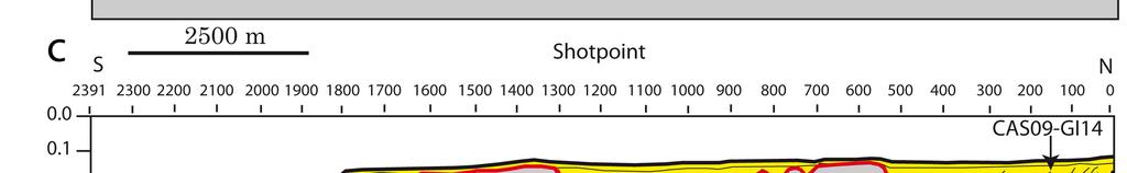


47
48
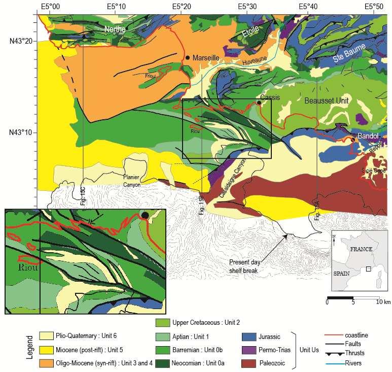
49
50
51

52


53
Sedimentary and Geodynamical 2D-3D Modeling of the Provence Continental Shelf during Mio-Pliocene Eustatic Events*
 Sedimentary and Geodynamical 2D-3D Modeling of the Provence Continental Shelf during Mio-Pliocene Eustatic Events* Aurélie Tassy 1, François Fournier, Jean Borgomano, Bruno Arfib, and Isabelle Thinon Search
Pre-Pliocene tectonostratigraphic framework of the Provence continental shelf (eastern Gulf of Lion, SE France)
") Bull. Soc. géol. France, 2016, t. 187, n o 4-5, pp. 187-216 Pre-Pliocene tectonostratigraphic framework of the Provence continental shelf (eastern Gulf of Lion, SE France) FRANÇOIS FOURNIER 1,AURÉLIE TASSY
Bull. Soc. géol. France, 2016, t. 187, n o 4-5, pp. 187-216 Pre-Pliocene tectonostratigraphic framework of the Provence continental shelf (eastern Gulf of Lion, SE France) FRANÇOIS FOURNIER 1,AURÉLIE TASSY
EGAS. Ministry of Petroleum
 EGAS Ministry of Petroleum EGAS Ministry of Petroleum About The Block Location: N. Thekah offshore block is located at about 56 km to the north of the Mediterranean shore line, 85 km to the north west
EGAS. Ministry of Petroleum
 EGAS Ministry of Petroleum EGAS Ministry of Petroleum About The Block Location: N. El Arish offshore block is located in the extreme eastern part of the Egypt s economic water border and bounded from the
Seismic stratigraphy, some examples from Indian Ocean, interpretation of reflection data in interactive mode
 Seismic stratigraphy, some examples from Indian Ocean, interpretation of reflection data in interactive mode K. S. Krishna National Institute of Oceanography, Dona Paula, Goa-403 004. krishna@nio.org Seismic
Controls on clastic systems in the Angoche basin, Mozambique: tectonics, contourites and petroleum systems
 P2-2-13 Controls on clastic systems in the Angoche basin, Mozambique: tectonics, contourites and petroleum systems Eva Hollebeek, Olivia Osicki, Duplo Kornpihl Schlumberger, London, UK Introduction Offshore
Meandering Miocene Deep Sea Channel Systems Offshore Congo, West Africa
 Meandering Miocene Deep Sea Channel Systems Offshore Congo, West Africa S. Baer* (PGS), J. E. Comstock (PGS), K. Vrålstad (PGS), R. Borsato (PGS), M. Martin (PGS), J.P. Saba (SNPC), B. Débi-Obambé (SNPC)
The Late Tertiary Deep-Water Siliciclastic System of the Levant Margin - An Emerging Play Offshore Israel*
 The Late Tertiary Deep-Water Siliciclastic System of the Levant Margin - An Emerging Play Offshore Israel* Michael A. Gardosh 1, Yehezkel Druckman 2 and Binyamin Buchbinder 2 Search and Discovery Article
Depositional Sequences Sequences
 Depositional Sequences Transgressive and Regressive packages can be bound by unconformities Because sediment can only be preserved during net aggradation and progradation All other times there is either
Continental Landscapes
 Continental Landscapes Landscape influenced by tectonics, climate & differential weathering Most landforms developed within the last 2 million years System moves toward an equilibrium Continental Landscapes
PLATEAU UPLIFT, EPEIROGENEY AND CLIMATE CHANGES The KALAHARI PLATEAU, a world class laboratory
 PLATEAU UPLIFT, EPEIROGENEY AND CLIMATE CHANGES The KALAHARI PLATEAU, a world class laboratory F. Guillocheau M. De Wit G. Dubois B. Linol F. Eckardt W. Cotterill D. Rouby C. Robin Géosciences-Rennes Université
APPENDIX C GEOLOGICAL CHANCE OF SUCCESS RYDER SCOTT COMPANY PETROLEUM CONSULTANTS
 APPENDIX C GEOLOGICAL CHANCE OF SUCCESS Page 2 The Geological Chance of Success is intended to evaluate the probability that a functioning petroleum system is in place for each prospective reservoir. The
Bulletin of Earth Sciences of Thailand
 Quantitative Seismic Geomorphology of Early Miocene to Pleistocene Fluvial System of Northern Songkhla Basin, Gulf of Thailand Oanh Thi Tran Petroleum Geoscience Program, Department of Geology, Faculty
Controls on facies distributions in the Charlie Lake Formation, Peace River Arch, Alberta
 Controls on facies distributions in the Charlie Lake Formation, Peace River Arch, Alberta E.L. Percy 12, C. Frostad 2, A. Juska 2, C. Schmidt 2, C. Sitzler 2, and J.P. Zonneveld 3 University of Calgary,
MUHAMMAD S TAMANNAI, DOUGLAS WINSTONE, IAN DEIGHTON & PETER CONN, TGS Nopec Geological Products and Services, London, United Kingdom
 Geological and Geophysical Evaluation of Offshore Morondava Frontier Basin based on Satellite Gravity, Well and regional 2D Seismic Data Interpretation MUHAMMAD S TAMANNAI, DOUGLAS WINSTONE, IAN DEIGHTON
Southern Songkhla Basin, Gulf of Thailand
 Architecture and Depositional Environment of Fluvial Systems of Southern Songkhla Basin, Gulf of Thailand Toan Manh Do Petroleum Geoscience Program, Department of Geology, Faculty of Science, Chulalongkorn
DATA REPOSITORY MATERIAL: PALEOCHANNEL GROUP MAPPING DESCRIPTIONS
 Data Repository item 2695 DATA REPOSITORY MATERIAL: PALEOCHANNEL GROUP MAPPING DESCRIPTIONS Groups 1 (North Myrtle Beach) and 2 (Atlantic Beach) Channel Groups 1 (North Myrtle Beach) and 2 (Atlantic Beach)
Sequence Stratigraphy as a tool for water resources management in alluvial coastal aquifers: application to the Llobregat delta (Barcelona, Spain)
") Sequence Stratigraphy as a tool for water resources management in alluvial coastal aquifers: application to the Llobregat delta (Barcelona, Spain) Desiré Gàmez Torrent December 2007 CHAPTER 1: Introduction
Sequence Stratigraphy as a tool for water resources management in alluvial coastal aquifers: application to the Llobregat delta (Barcelona, Spain) Desiré Gàmez Torrent December 2007 CHAPTER 1: Introduction
Perspectives from Offshore Argentina & Uruguay
 Perspectives from Offshore Argentina & Uruguay A Prospectivity Overview Hannah Kearns October 2018 Introduction Argentina Offshore License Round 1 14 blocks Argentina North, 24 Austral-Malvinas Offshore
Case Study of the Structural and Depositional-Evolution Interpretation from Seismic Data*
 Case Study of the Structural and Depositional-Evolution Interpretation from Seismic Data* Yun Ling 1, Xiangyu Guo 1, Jixiang Lin 1, and Desheng Sun 1 Search and Discovery Article #20143 (2012) Posted April
Sedimentary Cycle Best Practice: Potential Eo-Oligocene Sediments in Western Indonesia*
 Sedimentary Cycle Best Practice: Potential Eo-Oligocene Sediments in Western Indonesia* Mellinda Arisandy 1 and I Wayan Darma 1 Search and Discovery Article #11008 (2017)** Posted November 6, 2017 *Adapted
Figure 1 Extensional and Transform Fault Interaction, Influence on the Upper Cretaceous Hydrocarbon System, Equatorial Margin, West Africa.
 Figure 1 Extensional and Transform Fault Interaction, Influence on the Upper Cretaceous Hydrocarbon System, Equatorial Margin, West Africa. Presented to the 10th PESGB/HGS Conference on Africa E + P September
Seismic Stratigraphy of the Fang Basin, Chiang Mai, Thailand Rungsun Nuntajun
 Chiang Mai J. Sci. 2009; 36(1) 77 Chiang Mai J. Sci. 2009; 36(1) : 77-82 www.science.cmu.ac.th/journal-science/josci.html Contributed Paper Seismic Stratigraphy of the Fang Basin, Chiang Mai, Thailand
Rockall Plateau. OCN 201: Shelf Sediments
 Rockall Plateau OCN 201: Shelf Sediments Classification by Size Classification by Mode of Formation Detrital sediments Transported and deposited as particles Derived from weathering of pre-existing rocks
GLY 155 Introduction to Physical Geology, W. Altermann. Press & Siever, compressive forces. Compressive forces cause folding and faulting.
 Press & Siever, 1995 compressive forces Compressive forces cause folding and faulting. faults 1 Uplift is followed by erosion, which creates new horizontal surface. lava flows Volcanic eruptions cover
Aptian/Albian Reservoir Development in the Jeanne d Arc Basin, Offshore Eastern Canada
 Aptian/Albian Reservoir Development in the Jeanne d Arc Basin, Offshore Eastern Canada Jonathan Marshall, Statoil Canada Ltd. Calgary, Alberta, Canada. jomars@statoil.com Introduction: The Jeanne d Arc
Structural Geology of the Mountains
 Structural Geology of the Mountains Clinton R. Tippett Shell Canada Limited, Calgary, Alberta clinton.tippett@shell.ca INTRODUCTION The Southern Rocky Mountains of Canada (Figure 1) are made up of several
Integrated well log and 3-D seismic data interpretation for the Kakinada area of KG PG offshore basin
 IOSR Journal of Applied Geology and Geophysics (IOSR-JAGG) e-issn: 2321 0990, p-issn: 2321 0982.Volume 5, Issue 4 Ver. II (Jul. Aug. 2017), PP 01-05 www.iosrjournals.org Integrated well log and 3-D seismic
Vail et al., 1977b. AAPG 1977 reprinted with permission of the AAPG whose permission is required for further use.
 Well 5 Well 4 Well 3 Well 2 Well 1 Vail et al., 1977b AAPG 1977 reprinted with permission of the AAPG whose permission is required for further use. Well 5 Well 4 Well 3 Well 2 Well 1 Vail et al., 1977b
Offshore Evidence for Uplift Rate Boundaries. Hans AbramsonWard Diablo Canyon SSHAC SSC Workshop 2 November 7, 2012
 Offshore Evidence for Uplift Rate Boundaries Hans AbramsonWard Diablo Canyon SSHAC SSC Workshop 2 November 7, 2012 Questions asked by the TI team Discuss your ability to distinguish and correlate offshore
Section 7. Reading the Geologic History of Your Community. What Do You See? Think About It. Investigate. Learning Outcomes
 Chapter 3 Minerals, Rocks, and Structures Section 7 Reading the Geologic History of Your Community What Do You See? Learning Outcomes In this section, you will Goals Text Learning Outcomes In this section,
17. SEISMIC SEQUENCES OF CAPE BOJADOR, NORTHWEST AFRICA
 17. SEISMIC SEQUENCES OF CAPE BOJADOR, NORTHWEST AFRICA K. Hinz, Bundesanstalt fur Geowissenschaften und Rohstoffe. Stilleweg 2, D-3000 Hannover 51, Federal Republic of Germany ABSTRACT In the seismic
Seismic interpretation. Principles of seismic stratigraphic interpretation
 Seismic interpretation Principles of seismic stratigraphic interpretation Seismic interpretation Seismic stratigraphy is a technical for interpreting stratigraphic information from seismic data. The resolution
Chapter 3. Geology & Tectonics
 Chapter 3 Geology & Tectonics 3.1 Geology The general geological features of Indonesia are shown in Figure 3.1. The basement formation is metamorphic and it is intruded with plutonic formations. They are
P. S. Basak, Ravi Kant, K. Yasodha, T. Mukherjee, P. Rajanarayana, Sucheta Dotiwala, V. K. Baid, P.H. Rao, V. Vairavan, ONGC
 P-483 Summary Delineation of pinch-outs within Panna Formation of Paleocene-Early Eocene sequence in and around South Mumbai Low to Identify Prospective Areas - A Case Study P. S. Basak, Ravi Kant, K.
Depositional Environments and Hydrocarbon Potential of Northern Ionian Sea
 Depositional Environments and Hydrocarbon Potential of Northern Ionian Sea Vasiliki Kosmidou George Makrodimitras Nick Papatheodorou Contents Area of Interest Studied Dataset Workflow SWIT and Paleolatitude
Search and Discovery Article #40536 (2010) Posted June 21, 2010
 Posted June 21, 2010") Modern Examples of Mass Transport Complexes, Debrite and Turbidite Associations: Geometry, Stratigraphic Relationships and Implications for Hydrocarbon Trap Development* Fabiano Gamberi 1, Marzia Rovere
Modern Examples of Mass Transport Complexes, Debrite and Turbidite Associations: Geometry, Stratigraphic Relationships and Implications for Hydrocarbon Trap Development* Fabiano Gamberi 1, Marzia Rovere
Orphan Basin, Offshore Newfoundland: New seismic data and hydrocarbon plays for a dormant Frontier Basin
 Orphan Basin, Offshore Newfoundland: New seismic data and hydrocarbon plays for a dormant Frontier Basin Jerry Smee* G&G Exploration Consulting, 301 400-3rd Avenue SW, Calgary, AB, T2P 4H2 Sam Nader, Paul
Structural Styles and Geotectonic Elements in Northwestern Mississippi: Interpreted from Gravity, Magnetic, and Proprietary 2D Seismic Data
 Structural Styles and Geotectonic Elements in Northwestern Mississippi: Interpreted from Gravity, Magnetic, and Proprietary 2D Seismic Data Nick Loundagin 1 and Gary L. Kinsland 2 1 6573 W. Euclid Pl.,
Structural and Petrophysical Characterization of Mixed Drain/Barrier Fault Zones in Carbonates: Example from the Castellas Fault (SE France)*
*") Structural and Petrophysical Characterization of Mixed Drain/Barrier Fault Zones in Carbonates: Example from the Castellas Fault (SE France)* Christophe Matonti 1, Juliette Lamarche 1, Yves Guglielmi 1,
Structural and Petrophysical Characterization of Mixed Drain/Barrier Fault Zones in Carbonates: Example from the Castellas Fault (SE France)* Christophe Matonti 1, Juliette Lamarche 1, Yves Guglielmi 1,
A Tectonostratigraphic History of Orphan Basin, Offshore Newfoundland, Canada
 A Tectonostratigraphic History of Orphan Basin, Offshore Newfoundland, Canada Lynn T. Dafoe*, Charlotte E. Keen, Graham L. Williams, and Sonya A. Dehler, Geological Survey of Canada, Dartmouth, NS Canada
Supplementary Material for Eighty million years of folding migration: new perspective on the Syrian Arc from Levant basin analysis
 GSA Data Repository 2018040 https://doi.org/10.1130/g39654.1 Supplementary Material for Eighty million years of folding migration: new perspective on the Syrian Arc from Levant basin analysis Sagy Yael,
Biostratigraphic and Lithostratigraphic Correlation of Sedimentary Strata in the Atlantic Coastal Plain
 Biostratigraphic and Lithostratigraphic Correlation of Sedimentary Strata in the Atlantic Coastal Plain Introduction to the Atlantic Coastal Plain (Please read this page prior to doing the lab) The Atlantic
Regional Paleogeography and Implications for Petroleum Prospectivity, Taranaki Basin, New Zealand*
 Regional Paleogeography and Implications for Petroleum Prospectivity, Taranaki Basin, New Zealand* Dominic P. Strogen 1, Kyle J. Bland 1, Jan R. Baur 1,2, and Peter R. King 1 Search and Discovery Article
Erosional processes and paleo-environmental changes in the Western Gulf of Lions (SW France) during the Messinian Salinity Crisis
 during the Messinian Salinity Crisis") Please note that this is an author-produced PDF of an article accepted for publication following peer review. The definitive publisher-authenticated version is available on the publisher Web site Marine
Please note that this is an author-produced PDF of an article accepted for publication following peer review. The definitive publisher-authenticated version is available on the publisher Web site Marine
Discovery of vast fluvial deposits provides evidence for. drawdown during the late Miocene Messinian salinity crisis
 1 2 3 4 5 6 7 GS ata Repository 2019062 iscovery of vast fluvial deposits provides evidence for drawdown during the late Miocene Messinian salinity crisis ndrew S. Madof 1, laudia ertoni 2, and Johanna
3/5/05 Dr. Stewart 1
 I. Physiography of Appalachian Mountains A. Introduction 1. These mountains extend from NE Canada to Georgia 2. They are the remains of a deeply eroded, ancient mountain chain once larger than the Himalayans
Accommodation. Tectonics (local to regional) Subsidence Uplift
 Subsidence Uplift") Accommodation Accommodation varies over time; it is the distance between a reference horizon and the sea surface (i.e. relative sea level). The space to be filled in with sediments or water What are the
Accommodation Accommodation varies over time; it is the distance between a reference horizon and the sea surface (i.e. relative sea level). The space to be filled in with sediments or water What are the
Sierro F.J. 1, Ledesma S. 2 and Flores J.A. 1
 Astrobiochronology of Late Neogene deposits near the Strait of Gibraltar (SW Spain). Implications for the tectonic control of the Messinian Salinity Crisis. Sierro F.J. 1, Ledesma S. 2 and Flores J.A.
DATA ANALYSIS AND INTERPRETATION
 III. DATA ANALYSIS AND INTERPRETATION 3.1. Rift Geometry Identification Based on recent analysis of modern and ancient rifts, many previous workers concluded that the basic structural unit of continental
Structural Style and Tectonic Evolution of the Nakhon Basin, Gulf of Thailand
 Structural Style and Tectonic Evolution of the Nakhon Basin, Gulf of Thailand Piyaphong Chenrai Petroleum Geoscience Program, Department of Geology, Faculty of Science, Chulalongkorn University, Bangkok
RELINQUISHMENT REPORT. License P1546 Block April 2009
 RELINQUISHMENT REPORT License P1546 Block 110-01 14 April 2009 Sherritt International Oil and Gas Limited 2000, 425-1 st street S.W., Calgary, Alberta Canada T2P 3L8 Telephone (403) 260-2900 Fax (403)
A comparison of structural styles and prospectivity along the Atlantic margin from Senegal to Benin. Peter Conn*, Ian Deighton* & Dario Chisari*
 A comparison of structural styles and prospectivity along the Atlantic margin from Senegal to Benin Overview Peter Conn*, Ian Deighton* & Dario Chisari* * TGS, Millbank House, Surbiton, UK, KT6 6AP The
Figure 1: Location and bathymetry of the study area. Gulf of Guinea. Cameroon. Congo. Gabon. PGS/DGH Gabon MegaSurvey Coverage (35000Km 2 ) Eq.
 Eq.") Deepwater hydrocarbon prospectivity analysis of offshore North and South Gabon Muhammad S Tamannai (*), Thomas Hansen (1), Ron Borsato (1), Jennifer Greenhalgh (1) Martial-Rufin Moussavou (2) & Landry
Deepwater hydrocarbon prospectivity analysis of offshore North and South Gabon Muhammad S Tamannai (*), Thomas Hansen (1), Ron Borsato (1), Jennifer Greenhalgh (1) Martial-Rufin Moussavou (2) & Landry
Carboniferous Stoddart Group: An integrated approach
 Carboniferous Stoddart Group: An integrated approach Abu Yousuf*, Department of Geoscience, University of Calgary, Calgary, Alberta yousufabu@hotmail.com and Charles M. Henderson, Department of Geoscience,
Seismic evidence for Messinian detrital deposits at the western Sardinia margin, northwestern Mediterranean
 Marine and Petroleum Geology 22 (2005) 757 773 www.elsevier.com/locate/marpetgeo Seismic evidence for Messinian detrital deposits at the western Sardinia margin, northwestern Mediterranean Françoise Sage
Block 43B - Onshore Oman
 Block 43B - Onshore Oman SUMMARY Block 43B is an 11,967 km 2 area located along the coastal area of Oman north of the Hajar Mountains. This is an unexplored region, both geographically and stratigraphically.
Supplementary Material
 GSA Data Repository item 2018118 Brardinoni, F., Picotti, V., Maraio, S., Paolo Bruno, P., Cucato, M., Morelli, C., and Mair, V., 2018, Postglacial evolution of a formerly glaciated valley: Reconstructing
Structural Geology Lab. The Objectives are to gain experience
 Geology 2 Structural Geology Lab The Objectives are to gain experience 1. Drawing cross sections from information given on geologic maps. 2. Recognizing folds and naming their parts on stereoscopic air
Outcrops from Every Continent and 20 Countries in 140 Contributions. Tor H. Nilsen, Roger D. Shew, Gary S. Steffens, and Joseph R.J. Studlick.
 Paper VIII Tor H. Nilsen, Roger D. Shew, Gary S. Steffens, and Joseph R.J. Studlick Editors Outcrops from Every Continent and 20 Countries in 140 Contributions http://bookstore.aapg.org Length ~ 23 m (75.5
South Pyrenean foreland basin
 South Pyrenean foreland basin 1 7 South Pyrenean foreland basin 1 8 South-Pyrenean Foreland basin S N Fore-bulge deformation Piggy-back B. Thrust nappes Basement Vergés & al, 2002 decollement Syntectonic
Depositional History and Petroleum Potential of Ombilin Basin, West Sumatra - Indonesia, Based on Surface Geological Data*
 Depositional History and Petroleum Potential of Ombilin Basin, West Sumatra - Indonesia, Based on Surface Geological Data* Yahdi Zaim 1, Litto Habrianta 2, Chalid I. Abdullah 1, Aswan 1, Yan Rizal 1, Nurcahyo
Geology (Mellow) Hike, Santa Lucia Memorial Park February 16, I. Overview of Santa Lucia Range geology and tectonic history
 Hike, Santa Lucia Memorial Park February 16, I. Overview of Santa Lucia Range geology and tectonic history") Geology (Mellow) Hike, Santa Lucia Memorial Park February 16, 2015 I. Overview of Santa Lucia Range geology and tectonic history A. Basement Rocks 1. Salinian Block Rocks Sierra Nevada Type, continental
Geology (Mellow) Hike, Santa Lucia Memorial Park February 16, 2015 I. Overview of Santa Lucia Range geology and tectonic history A. Basement Rocks 1. Salinian Block Rocks Sierra Nevada Type, continental
Abstract. Introduction. Regional Setting. GCSSEPM to be published December 2003
 Shelf Margin Deltas and Associated Deepwater Deposits: Implications on Reservoir Distribution and Hydrocarbon Entrapment, Block VI-1, Ulleung Basin, East Sea, South Korea Sneider, John S. Sneider Exploration,
Evaluation of Neocomian Shale source rock In Komombo Basin, Upper Egypt
 Evaluation of Neocomian Shale source rock In Komombo Basin, Upper Egypt Abdelhady, A. 1, Darwish, M. 2, El Araby, A. 3 and Hassouba, A. 4 1 DEA Egypt, Cairo, Egypt 2 Geology Department, Faculty of Science,
The West Mediterranean Salt Basin A Future Petroleum Producing Province?*
 The West Mediterranean Salt Basin A Future Petroleum Producing Province?* Glyn Roberts 1 and Trond Christoffersen 2 Search and Discovery Article #50791 (2013) Posted June 17, 2013 *Adapted from extended
Figure 1. Examples of vector displacement diagrams for two and three-plate systems.
 Figure 1. Examples of vector displacement diagrams for two and three-plate systems. Figure 2. Relationships between pole of rotation, great circles, ridge segments, small circles, transforms and fracture
The Mesozoic. Wednesday, November 30, 11
 The Mesozoic Periods of the Mesozoic Triassic- First period of the Mesozoic era Jurassic Cretaceous- Last period of the Mesozoic era Breakup of Pangaea Stage one (Triassic) Rifting and volcanism, normal
PETROLEUM GEOLOGY OF THE RUSSIAN FAR-EAST
 Contents - 1 PETROLEUM GEOLOGY OF THE RUSSIAN FAR-EAST CONTENTS PART I: INTRODUCTION TO THE RUSSIAN FAR EAST AND ITS STRUCTURAL DEVELOPMENT. Chapter 1. The Russian Far East: Introduction and Infrastructure.
Future giant discovery in the Outeniqua Basin, offshore South Africa. Anongporn Intawong & Neil Hodgson
 Future giant discovery in the Outeniqua Basin, offshore South Africa Anongporn Intawong & Neil Hodgson Spectrum Geoscience 23 February 2017 1 Talk Outlines Structural framework & Evolution of the South
Arthur Saller 1. Search and Discovery Article #51393 (2017)** Posted June 26, Abstract
** Posted June 26, Abstract") PS Mixed Carbonates and Siliciclastics North of the Mahakam Delta, Offshore East Kalimantan, Indonesia* Arthur Saller 1 Search and Discovery Article #51393 (2017)** Posted June 26, 2017 *Adapted from poster
PS Mixed Carbonates and Siliciclastics North of the Mahakam Delta, Offshore East Kalimantan, Indonesia* Arthur Saller 1 Search and Discovery Article #51393 (2017)** Posted June 26, 2017 *Adapted from poster
Sequence stratigraphy and basin analysis of the Meso- to Cenozoic Tarfaya- Laayoune Basins, on- and offshore Morocco
 Sequence stratigraphy and basin analysis of the Meso- to Cenozoic Tarfaya- Laayoune Basins, on- and offshore Morocco INAUGURAL-DISSERTATION zur Erlangung der Doktorwtirde der Naturwissenschaftlich-Mathematischen
The Sierra Leone-Liberia Emerging Deepwater Province*
 The Sierra Leone-Liberia Emerging Deepwater Province* Joan F. Flinch 1, José L. Huedo 1, Hernán Verzi 1, Héctor González 1, Ricardo Gerster 1, Abdul K. Mansaray 1, L. P. Painuly 1, Leticia Rodriguez-Blanco
Blocks 31, 32, 33, 34, 35 & 36/03 Southeast Offshore Vietnam
 Blocks 31, 32, 33, 34, 35 & 36/03 Southeast Offshore Vietnam Block 31 32 33 34 35 36/03 Area (km 2) 5,036 4,440 4,630 4,700 4,630 2,950 Sea level (m) 20 20-30 30-40 50 50 50 Seismic 2D (km) 1,294 685 431
Chapter 8 Fetter, Applied Hydrology 4 th Edition, Geology of Groundwater Occurrence
 Chapter 8 Fetter, Applied Hydrology 4 th Edition, 2001 Geology of Groundwater Occurrence Figure 8.42. Alluvial Valleys ground-water region. Fetter, Applied Hydrology 4 th Edition, 2001 Fetter, Applied
Request For Bids Parcels
 Section 2 Page 14 This section provides a detailed description of each landsale parcel. Maps provided show the location of the land parcels and the released seismic data on those parcels. Hard copies and
Application of Predictive Modeling to the Lower Cretaceous Sedimentary Sequences of the Central Scotian Basin
 Application of Predictive Modeling to the Lower Cretaceous Sedimentary Sequences of the Central Scotian Basin Christopher R. Sangster 1, Nicolas Hawie 2, Georgia Pe-Piper 1, Francky Saint-Ange 2, David
Answers: Internal Processes and Structures (Isostasy)
") Answers: Internal Processes and Structures (Isostasy) 1. Analyse the adjustment of the crust to changes in loads associated with volcanism, mountain building, erosion, and glaciation by using the concept
Answers: Internal Processes and Structures (Isostasy) 1. Analyse the adjustment of the crust to changes in loads associated with volcanism, mountain building, erosion, and glaciation by using the concept
Dakota Sandstone. of the Moxa Arch and Surrounding Green River Basin
 Dakota Sandstone of the Moxa Arch and Surrounding Green River Basin Dakota Sandstones of the Green River Basin Overview The Dakota sandstones of the Moxa Arch and surrounding Green River Basin remain attractive
East Africa Transform Margin The View from Tanzania and Madagascar
 East Africa Transform Margin The View from Tanzania and Madagascar Richard Higgins and Mark Sofield 10 th PESGB/HGS Conference on African E & P, London, September 7-8, 2011 Acknowledgements Legal Notice:
IRAQ. Target Exploration. Geodynamic Evolutions of The Sedimentary Basins of. This study is a major reference for Petroleum
 barr Target Exploration Target Exploration Geodynamic Evolutions of The Sedimentary Basins of IRAQ This study is a major reference for Petroleum Explorationists on the tectonics, stratigraphy, sedimentary
Sequence Stratigraphic Analysis of Mixed, Reefal Carbonate and Siliciclastic Systems. Ashton Embry. Geological Survey of Canada.
 Sequence Stratigraphic Analysis of Mixed, Reefal Carbonate and Siliciclastic Systems Ashton Embry Geological Survey of Canada Outline Sequence Stratigraphy Sequence Surfaces and Sequence Boundaries for
SEDIMENTARY BASINS BASIN TYPES ACCORDING TO TECTONIC. by Prof. Dr. Abbas Mansour
 SEDIMENTARY BASINS BASIN TYPES ACCORDING TO TECTONIC by Prof. Dr. Abbas Mansour B. Convergent plate margins 10. STABLE CONTINENTAL INTERIOR BASIN E.g. Lake Eyre Basin Intracratonic (= within stable continental
Ministry of Oil and Minerals Petroleum Exploration & Production Authority BLOCK 85 (Al Uqlah North)
") Ministry of Oil and Minerals Petroleum Exploration & Production Authority BLOCK 85 (Al Uqlah North) The Al Uqlah North Block (85) occupies an area of 597 km 2 in the Sabatayn Basin in the province of Shabwah
Ministry of Oil and Minerals Petroleum Exploration & Production Authority BLOCK 85 (Al Uqlah North) The Al Uqlah North Block (85) occupies an area of 597 km 2 in the Sabatayn Basin in the province of Shabwah
Neotectonic Implications between Kaotai and Peinanshan
 Neotectonic Implications between Kaotai and Peinanshan Abstract Longitudinal Valley was the suture zone between the Philippine Sea plate and the Eurasia plate. Peinanshan was the southest segment of the
Basin Analysis Applied to Modelling Buried Valleys in the Great Lakes Basin
 EARTH SCIENCES SECTOR GENERAL INFORMATION PRODUCT 35 Basin Analysis Applied to Modelling Buried Valleys in the Great Lakes Basin Sharpe, D R; Russell, H A J 2004 Originally released as: Basin Analysis
Ministry of Oil and Minerals Petroleum Exploration & Production Authority BLOCK 6 (Iryam)
") Ministry of Oil and Minerals Petroleum Exploration & Production Authority BLOCK 6 (Iryam) The Iryam Block (6) occupies an area of 3,911 km 2 in the Sabatayn Basin in the province of Shabwah in central
Ministry of Oil and Minerals Petroleum Exploration & Production Authority BLOCK 6 (Iryam) The Iryam Block (6) occupies an area of 3,911 km 2 in the Sabatayn Basin in the province of Shabwah in central
BALOCHISTAN FOLDBELT BASIN
 INTRODUCTION BALOCHISTAN FOLDBELT BASIN The Kharan-3 block is located in the Kharan Trough of Balochistan Basin. GEOLOGICAL SETTING The Balochistan Province is an Upper Cretaceous to Recent structurally
GLY Coastal Geomorphology Notes
 GLY 4734 - Coastal Geomorphology Notes Dr. Peter N. Adams Spring 2011 2 Coastal Classification In this lecture, we discuss some successful classification schemes of the coastal landscape, and pay particular
SEQUENCE STRATIGRAPHY
 SEQUENCE STRATIGRAPHY Course of Stratigraphy G301 Second semester (February-June2014) Department of Geology College of Science/University of Basrah Instructor:Dr. Nawrast S. Abd Alwahab Lecture 4 & 5 1
Airborne gravity gradiometer surveying of petroleum systems under Lake Tanganyika, Tanzania
 Airborne gravity gradiometer surveying of petroleum systems under Lake Tanganyika, Tanzania D. Roberts Beach Energy P. Roy Chowdhury CGG S. J. Lowe CGG A. N. Christensen CGG Outline Introduction Geology
Cenozoic Extensional Basin Development and Sedimentation in SW Montana
 Cenozoic Extensional Basin Development and Sedimentation in SW Montana Robert C. Thomas Department of Environmental Sciences, The University of Montana Western, Dillon, MT 59725, (406) 683-7615, r_thomas@umwestern.edu
Hints of active deformation in the southern Adriatic foreland: Holocene tectonics along the Apulia offshore (Italy)
") Hints of active deformation in the southern Adriatic foreland: Holocene tectonics along the Apulia offshore (Italy) Domenico Ridente^, Umberto Fracassi*, Daniela Di Bucci, Fabio Trincardi^ ^ & Gianluca
Hints of active deformation in the southern Adriatic foreland: Holocene tectonics along the Apulia offshore (Italy) Domenico Ridente^, Umberto Fracassi*, Daniela Di Bucci, Fabio Trincardi^ ^ & Gianluca
A Simplified Guide For Sequence Stratigraphy:
 SEPM Society for Sedimentary Geology A Simplified Guide For Sequence Stratigraphy: Nomenclature, Definitions and Method Vitor Abreu President - SEPM Abstract All attempts to codify Sequence Stratigraphy
CHAPTER 4 SEISMIC INTERPRETATION
 CHAPTER 4 SEISMIC INTERPRETATION CHAPTER 4.1 DATABASE FOR SEISMIC INTERPRETATION SEISMIC INTERPRETATION - WELL TO SEISMIC CALIBRATION Central Scotian Slope Study CANADA July 2016 Seismic database The
Kilometre-Scale Uplift of the Early Cretaceous Rift Section, Camamu Basin, Offshore North-East Brazil*
 Kilometre-Scale Uplift of the Early Cretaceous Rift Section, Camamu Basin, Offshore North-East Brazil* Iain Scotchman 1 and Dario Chiossi 2 Search and Discovery Article #50183 (2009) Posted May 20, 2009
Structural Geology Lab. The Objectives are to gain experience
 Geology 2 Structural Geology Lab The Objectives are to gain experience 1. Drawing cross sections from information given on geologic maps. 2. Recognizing folds and naming their parts on stereoscopic air
Evidence for pre-messinian submarine canyons on the Gulf of Lions slope (Western Mediterranean)
") Please note that this is an author-produced PDF of an article accepted for publication following peer review. The definitive publisher-authenticated version is available on the publisher Web site Marine
Please note that this is an author-produced PDF of an article accepted for publication following peer review. The definitive publisher-authenticated version is available on the publisher Web site Marine
Project Document. BASE - Basement fracturing and weathering on- and offshore Norway Genesis, age, and landscape development
 Project Document BASE - Basement fracturing and weathering on- and offshore Norway Genesis, age, and landscape development Partners: Geological Survey of Norway (NGU), SINTEF Petroleum Research (SINTEF)
Introduction to sequence stratigraphy and its application to reservoir geology
 Introduction to sequence stratigraphy and its application to reservoir geology Massimo Zecchin Istituto Nazionale di Oceanografia e di Geofisica Sperimentale - OGS Historical development Definitions Systems