Hints of active deformation in the southern Adriatic foreland: Holocene tectonics along the Apulia offshore (Italy)
|
|
|
- Edmund Farmer
- 5 years ago
- Views:
Transcription


1 Hints of active deformation in the southern Adriatic foreland: Holocene tectonics along the Apulia offshore (Italy) Domenico Ridente^, Umberto Fracassi*, Daniela Di Bucci, Fabio Trincardi^ ^ & Gianluca Valensise* * ^ Adria 2006, International Geological Congress on the Adriatic Area - Urbino (Italy), Special session: Seismotectonics and seismic hazard of the Adria region
 Geological and geophysical framework The VHR seismic reflection data Some results and some")
2 What are we going to talk about? The issue: active tectonics W of the Gargano Promontory (?) Geological and geophysical framework The VHR seismic reflection data Some results and some concluding remarks
3 The issue: Is the Gondola Line active? The 2002 Molise seismic sources are located along the western part of a regional fault system, the Molise-Gondola shear zone (MGsz; Di Bucci et al., Tectonics, in press) On land, this system is mainly represented by the Mattinata Fault, with a polyphase activity since the Mesozoic. Present-day activity with right-lateral motion is confirmed by recent seismicity (1975, 1995 and 2006 earthquakes), GPS data, geomorphological and paleoseismological data Off-shore, the Mattinata Fault is aligned with the regional, E-W E to NW-SE oriented Gondola Line. Its multi-history deformation pattern closely resembles the long-term complex evolution of the Mattinata Fault, except for the lack of significant seismicity

4 Main historical and instrumental seismicity
 Geological and geophysical framework The VHR seismic reflection data Some results and some concluding remarks (from: Di")
5 What are we going to talk about? The issue: active tectonics W of the Gargano Promontory (?) Geological and geophysical framework The VHR seismic reflection data Some results and some concluding remarks (from: Di Bucci et al., Tectonics, in press)h

6 Main geological features of southern Italy Genova 9 E 44 N Bologna Ravenna Rimini Pliocene-Quaternary terrigenous deposits Magmatic units I T A L Y Livorno Firenze Tuscany Pesaro Ancona Liguride units and related wedge-top basin deposits Tuscan pelagic basin, and related foredeep deposits Umbria-Marche pelagic basin, slopes and related foredeep deposits Laga Fm., Gessoso-Solfifera and related deposits Pescara Tremiti Islands (mod., from: Butler et al., AAPG TT 99 Spec. Vol., 2004) Gargano promontory Roma Mattinata fault study area Gondola line Metamorphic units Molise-Sannio-Lagonegro pelagic basin, slopes and related foredeep deposits Apennine carbonate platform, by-pass margins and related foredeep deposits Apulia carbonate platform and related foredeep deposits Main thrusts fronts Napoli Bari APULIAN FORELAND Matera Potenza Main faults Main buried thrust fronts km (modified from: Butler et al., 2004) Calabrian arc


7 Analogue experiment of the right-lateral reactivation of the Mattinata-Gondola sz (from: Di Bucci et al., Tectonics, in press)

8 Regional shear zones offshore Apulia (mod., from: Morelli, Mem. SGI, 2002)
 Geological and geophysical framework The VHR seismic reflection data Some results and some")
9 What are we going to talk about? The issue: active tectonics W of the Gargano Promontory (?) Geological and geophysical framework The VHR seismic reflection data Some results and some concluding remarks


10 Our dataset on map ADRIATIC SEA
11 Our dataset characteristics A network of high-resolution seismic profiles (2-7 7 khz Chirp- Sonar, 3.5 khz Sub-bottom, bottom, 500 joule Uniboom,, 1 kjoule Sparker) and core data Chirp-Sonar seismic lines, with very high vertical resolution (ca. 50 cm) and vertical exaggeration up to 100 times Sedimentological and chrono-stratigraphic constraints provided by sediment cores and borehole (PRAD 1-2) 1 This dataset allows to investigate the upper m of the Quaternary succession, i.e. the middle-late late Pleistocene and Holocene interval

12 Depositional sequences

13 Structural map summary -40 m -150 m main fold axis 5 km faulting only on the northern limb N

14 Close-up on structural map 1 folding gives room to faulting 2 km

15 Close-up on structural map 2 faulting not affecting Holocene deposits faulting rupturing the seabed 1 km

16 Close-up on structural map 3 faulting not affecting Holocene deposits folding gives room to faulting faulting rupturing the seabed 2 km

17 An example of our VHR Chirp data AMC 155 NNE SSW
18 An example of our VHR Chirp data This is a fault! This is not a fault! It s not that easy, though


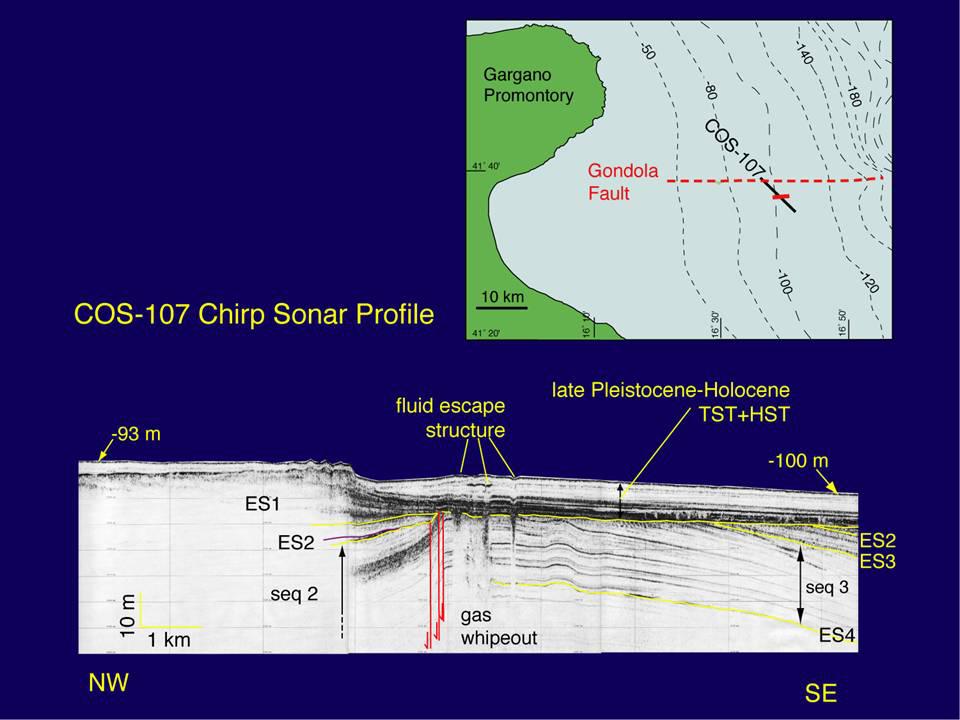
19 A YD60 AMC155 seq2 Gondola fault YD207 pre-tectonic strata A (mod., from: Ridente and Trincardi, Bas. Res., 2006)
20
")
21 Enlightening data, indeed but how do they fit in the known picture? (from: Gambini & Tozzi, 1995)
22 Gondola fault A 10 km B D452 MC Profile D452 Base PQ NE A B 3.2 km 1 sec TWT SW


23 Gondola fault AMC155 A 10 km B D452 Chirp Sonar Profile AMC-155 fault dip angle N S MC Profile D452 Base PQ NE A B 3.2 km 1 sec TWT SW

24 Gondola fault A 10 km D451 B MC Profile D451 Data gap Base PQ 1 sec TWT NE A 3.2 km SW


25 Gondola fault YD60 A NE Chirp Sonar Profile YD km D451 B SW fault dip angle MC Profile D451 Data gap Base PQ 1 sec TWT NE A 3.2 km SW
26 What can be observed I? Two main asymmetric similar folds, with E-W-oriented E parallel crest lines. The northern limbs, i.e. those slightly more inclined, are also affected by faults The northern anticline is more developed, and the deformation affecting its northern limb consists of a set of left-stepping, alternating faults and small anticlines Faults exhibit very steep dip and a normal component of motion that causes their northern side to be downthrown to about ten metres Mean vertical slip rate for the late Pleistocene and Holocene is i ca mm/a. The comparison of the length of these faults with their limited vertical displacement suggests the possible occurrence of a significant horizontal component of motion
27 What can be observed II? Deformation pattern affects the middle and late Pleistocene deposits. In some places faults also displace Holocene deposits and the seabed The two main fold show comparable shape, wavelength, amplitude, faulted northern limb, and this leads to interpret them jointly as evidence of one deformation system Being the Gondola Line located below the analysed structures, we interpret the deformation pattern as due to the reactivation of this major inherited lineament caused by a compressional component of the stress field
28 So, we are looking at an active fault close to a well known seismogenic source Seismicity related to E-W E W dextral strike-slip slip tectonics along the Mattinata Fault, and very recent (< 5.5 ka) deformation features along the Gondola Line, suggest that the MGsz as a whole is being actively deformed, variably along-strike Gondola Line shows close affinities with the other parts of the MGsz on-shore. It is an E-W E W oriented inherited structure, reactivated during the late Pleistocene and Holocene. A strike- slip component of motion can be associated to this structure. The Gondola activity can be due to a stress field that, like in the case of the Mattinata fault and 2002 Molise earthquakes sources, is compatible with the NW-SE SE-oriented Africa-Europe convergence. Considering the seismogenic nature of the other parts of the MGsz,, one can hypothesize the same behaviour also for the Gondola Line.

29 Thank you prints.org
VHR seismic imaging of displacement along an active off-shore fault system of the Adriatic foreland
 VHR seismic imaging of displacement along an active off-shore fault system of the Adriatic foreland Daniela Di Bucci 1, Domenico Ridente 2, 3, Umberto Fracassi 4, Fabio Trincardi 2, Gianluca Valensise
Depositional Environments and Hydrocarbon Potential of Northern Ionian Sea
 Depositional Environments and Hydrocarbon Potential of Northern Ionian Sea Vasiliki Kosmidou George Makrodimitras Nick Papatheodorou Contents Area of Interest Studied Dataset Workflow SWIT and Paleolatitude
Data Repository Item
 Parente, 1 30 N Ir P V 20 N A G Emerged land Terrigenous shelf and shallow basin Platform limestone Slope and basin above CCD Deep basin Active spreading ridge Oceanic subduction Thrust, fault 10 N Figure
Ionian Sea and Margins: Recent Prospections and Interpretations
 Ionian Sea and Margins: Recent Prospections and Interpretations Liliana Minelli co-authors: Faccenna C., Casero P. Dipartimento Scienze Geologiche Università Roma Tre 9th Offshore Mediterranean Conference
Monitoring techniques developed at CO2 natural laboratories to improve risks assessment and safety strategy
 Monitoring techniques developed at CO2 natural laboratories to improve risks assessment and safety strategy Sabina Bigi Dipartimento di Scienze della Terra Sapienza Università di Roma 3 rd International
Monitoring long-term ground movements and Deep Seated Gravitational
 Monitoring long-term ground movements and Deep Seated Gravitational Slope Deformations by InSAR time series: cases studies in Italy Salvatore Stramondo (1), M. Saroli (1, 2), M. Moro (1, 2), S. Atzori
Kinematic inversion of pre-existing faults by wastewater injection-related induced seismicity: the Val d Agri oil field case study (Italy)
") Kinematic inversion of pre-existing faults by wastewater injection-related induced seismicity: the Val d Agri oil field case study (Italy) Buttinelli M., Improta L., Bagh S., Chiarabba C. 1/10 The Val
Kinematic inversion of pre-existing faults by wastewater injection-related induced seismicity: the Val d Agri oil field case study (Italy) Buttinelli M., Improta L., Bagh S., Chiarabba C. 1/10 The Val
Project S1: Analysis of the seismic potential in Italy for the evaluation of the seismic hazard
 Agreement INGV-DPC 2007-2009 Project S1: Analysis of the seismic potential in Italy for the evaluation of the seismic hazard Responsibles: Salvatore Barba, Istituto Nazionale di Geofisica e Vulcanologia,
UNIT 10 MOUNTAIN BUILDING AND EVOLUTION OF CONTINENTS
 UNIT 10 MOUNTAIN BUILDING AND EVOLUTION OF CONTINENTS ROCK DEFORMATION Tectonic forces exert different types of stress on rocks in different geologic environments. STRESS The first, called confining stress
Earth Science, (Tarbuck/Lutgens) Chapter 10: Mountain Building
 Chapter 10: Mountain Building") Earth Science, (Tarbuck/Lutgens) Chapter 10: Mountain Building 1) A(n) fault has little or no vertical movements of the two blocks. A) stick slip B) oblique slip C) strike slip D) dip slip 2) In a(n) fault,
Earth Science, (Tarbuck/Lutgens) Chapter 10: Mountain Building 1) A(n) fault has little or no vertical movements of the two blocks. A) stick slip B) oblique slip C) strike slip D) dip slip 2) In a(n) fault,
Neogene-Quaternary intraforeland transpression along a Mesozoic platform-basin margin: The Gargano fault system, Adria, Italy
 Neogene-Quaternary intraforeland transpression along a Mesozoic platform-basin margin: The Gargano fault system, Adria, Italy Andrea Billi* Dipartimento di Scienze Geologiche, Università Roma Tre, Largo
Answers: Internal Processes and Structures (Isostasy)
") Answers: Internal Processes and Structures (Isostasy) 1. Analyse the adjustment of the crust to changes in loads associated with volcanism, mountain building, erosion, and glaciation by using the concept
Answers: Internal Processes and Structures (Isostasy) 1. Analyse the adjustment of the crust to changes in loads associated with volcanism, mountain building, erosion, and glaciation by using the concept
NATURAL ENVIRONMENT. Geophysics
 NATURAL ENVIRONMENT Geophysics Geodynamics Alpine, Carpathian and Dinaric mountain belts surround the Pannonian (Carpathian) Basin, of Neogene through Quaternary in age. The Cenozoic evolution of the Alpine-Pannonian
Domenico Ridente a, Umberto Fracassi b, Daniela Di Bucci c, Fabio Trincardi a, Gianluca Valensise b
 Middle Pleistocene to Holocene activity of the Gondola Fault Zone (Southern Adriatic Foreland): deformation of a regional shear zone and seismotectonic implications Domenico Ridente a, Umberto Fracassi
INGV. Giuseppe Pezzo. Istituto Nazionale di Geofisica e Vulcanologia, CNT, Roma. Sessione 1.1: Terremoti e le loro faglie
 Giuseppe Pezzo Istituto Nazionale di Geofisica e Vulcanologia, CNT, Roma giuseppe.pezzo@ingv.it The study of surface deformation is one of the most important topics to improve the knowledge of the deep
High resolution seismic imaging of the M w 5.7, 2002 Molise, southern Italy, earthquake area: Evidence of deep fault reactivation
 Click Here for Full Article High resolution seismic imaging of the M w 5.7, 2002 Molise, southern Italy, earthquake area: Evidence of deep fault reactivation Diana Latorre, 1 Alessandro Amato, 1 and Claudio
New insights on some structural geometries in Southern Apennines by multiscale analysis of potential fields
 New insights on some structural geometries in Southern Apennines by multiscale analysis of potential fields F. Cella ( 1 ), L. Ferranti ( 2 ), G. Florio ( 2 ) and L. Maschio ( 2 ) ( 1 ) Dipartimento di
Crustal Deformation. (Building Earth s Surface, Part 1) Science 330 Summer Mapping geologic structures
 Science 330 Summer Mapping geologic structures") Crustal Deformation (Building Earth s Surface, Part 1) Science 330 Summer 2005 Mapping geologic structures When conducting a study of a region, a geologist identifies and describes the dominant rock structures
Crustal Deformation (Building Earth s Surface, Part 1) Science 330 Summer 2005 Mapping geologic structures When conducting a study of a region, a geologist identifies and describes the dominant rock structures
KEY CHAPTER 12 TAKE-HOME QUIZ INTERNAL STRUCTURES AND PROCESSES Score Part B = / 55 PART B
 GEOLOGY 12 KEY CHAPTER 12 TAKE-HOME QUIZ INTERNAL STRUCTURES AND PROCESSES Score Part B = / 55 PART B CHAPTER 12 Isostacy and Structural Geology 1. Using the terms below, label the following diagrams and
Lecture # 6. Geological Structures
 1 Lecture # 6 Geological Structures ( Folds, Faults and Joints) Instructor: Dr. Attaullah Shah Department of Civil Engineering Swedish College of Engineering and Technology-Wah Cantt. 2 The wavy undulations
Earthquakes in Barcelonnette!
 Barcelonnette in the Ubaye valley : the landscape results of large deformations during the alpine orogene (40 5 Myr in this area) and the succession of Quaternary glaciations. The sedimentary rocks are
8.0 SUMMARY AND CONCLUSIONS
 8.0 SUMMARY AND CONCLUSIONS In November 2008, Pacific Gas and Electric (PG&E) informed the U.S. Nuclear Regulatory Commission (NRC) that preliminary results from the Diablo Canyon Power Plant (DCPP) Long
South Pyrenean foreland basin
 South Pyrenean foreland basin 1 7 South Pyrenean foreland basin 1 8 South-Pyrenean Foreland basin S N Fore-bulge deformation Piggy-back B. Thrust nappes Basement Vergés & al, 2002 decollement Syntectonic
11.1 Rock Deformation
 Tarbuck Lutgens Mountain Building 11.1 Rock Deformation Factors Affecting Deformation Factors that influence the strength of a rock and how it will deform include temperature, confining pressure, rock
Study the architecture and processes responsible for deformation of Earth s crust. Folding and Faulting
 Crustal Deformation AKA Structural geology (adapted from Brunkel, 2012) Study the architecture and processes responsible for deformation of Earth s crust. Folding and Faulting How Rocks Deform: 4 Controls
The Buried Fold-and-Thrust Belt in Sicily: Perspectives for Future Exploration*
 The Buried Fold-and-Thrust Belt in Sicily: Perspectives for Future Exploration* R. Catalano 1, A. Sulli 1, V. Valenti 1, G. Avellone 1, L. Basilone 1, M. Gasparo Morticelli 1, C. Albanese 1, M. Agate 1,
Chapter 16. Mountain Building. Mountain Building. Mountains and Plate Tectonics. what s the connection?
 Chapter 16 Mountains and Plate Tectonics what s the connection? Mountain Building Most crustal deformation occurs along plate margins. S.2 Active Margin Passive Margin Mountain Building Factors Affecting
Structural Style and Tectonic Evolution of the Nakhon Basin, Gulf of Thailand
 Structural Style and Tectonic Evolution of the Nakhon Basin, Gulf of Thailand Piyaphong Chenrai Petroleum Geoscience Program, Department of Geology, Faculty of Science, Chulalongkorn University, Bangkok
Dipartimento di Scienze Biologiche, Geologiche e Ambientali, Sezione di Scienze della Terra, Università di Catania, Italy 2
 Structural pattern and active deformation in the northern sector of the Aeolian-Tindari-Letojanni fault system in the geodynamic framework of the southern Calabrian Arc: an integrated analysis of field,
Crustal Deformation Earth - Chapter Pearson Education, Inc.
 Crustal Deformation Earth - Chapter 10 Structural Geology Structural geologists study the architecture and processes responsible for deformation of Earth s crust. A working knowledge of rock structures
Structural Geology and Geology Maps Lab
 Structural Geology and Geology Maps Lab Mesa College Geology 101 Lab Ray Rector: Instructor Structural Geology Lab Pre-Lab Resources Pre-Lab Internet Links 1) Fundamentals of Structural Geology 2) Visualizing
Fourth Energy Summit Sustainable, competitive and secure energy in Europe. Avraam Zelilidis, Professor Department of Geology, University of Patras
 Fourth Energy Summit Sustainable, competitive and secure energy in Europe Monday 14 th November 2011, Nicosia Cyprus The status of energy exploration in Cyprus and its geostrategic significance for the
Chapter 10: Deformation and Mountain Building. Fig. 10.1
 Chapter 10: Deformation and Mountain Building Fig. 10.1 OBJECTIVES Describe the processes of rock deformation and compare and contrast ductile and brittle behavior in rocks. Explain how strike and dip
The Sorong Fault Zone Kinematics: The Evidence of Divergence and Horsetail Structure at NW Bird's Head and Salawati Basin, West Papua, Indonesia*
 The Sorong Fault Zone Kinematics: The Evidence of Divergence and Horsetail Structure at NW Bird's Head and Salawati Basin, West Papua, Indonesia* Putri Riadini 1 and Benyamin Sapiie 2 Search and Discovery
Chapter 2. Earthquake and Damage
 EDM Report on the Chi-Chi, Taiwan Earthquake of September 21, 1999 2.1 Earthquake Fault 2.1.1 Tectonic Background The island of Taiwan is located in the complex junction where the Eurasian and Philippine
Blocks 31, 32, 33, 34, 35 & 36/03 Southeast Offshore Vietnam
 Blocks 31, 32, 33, 34, 35 & 36/03 Southeast Offshore Vietnam Block 31 32 33 34 35 36/03 Area (km 2) 5,036 4,440 4,630 4,700 4,630 2,950 Sea level (m) 20 20-30 30-40 50 50 50 Seismic 2D (km) 1,294 685 431
TECTONIC AND STRUCTURAL CONTROLS ON INTRUSION- RELATED DEPOSITS IN THE NORTHERN PART OF SREDNA GORA ZONE, BULGARIA NIKOLAY PETROV & KAMELIA NEDKOVA
 TECTONIC AND STRUCTURAL CONTROLS ON INTRUSION- RELATED DEPOSITS IN THE NORTHERN PART OF SREDNA GORA ZONE, BULGARIA NIKOLAY PETROV & KAMELIA NEDKOVA INVESTIGATED AREA Praveshka Lakavica deposit Elatsite
Lateral extrusion and tectonic escape in Ilan Plain of northeastern Taiwan
 Lateral extrusion and tectonic escape in Ilan Plain of northeastern Taiwan Angelier, J., Chang, T.Y., Hu, J.C., Chang, C.P., Siame, L., Lee, J.C., Deffontaines, B., Chu, H.T, Lu, C.Y., Does extrusion occur
Copyright McGraw-Hill Education. All rights reserved. No reproduction or distribution without the prior written consent of McGraw-Hill Education
 Copyright McGraw-Hill Education. All rights reserved. No reproduction or distribution without the prior written consent of McGraw-Hill Education Tibetan Plateau and Himalaya -southern Asia 11.00.a VE 10X
Hosgri-San Simeon Fault Zone Geologic Slip Rate
 Hosgri-San Simeon Fault Zone Geologic Slip Rate Insert picture(s) here Kathryn Hanson AMEC E&I Diablo Canyon SSHAC Project SSC Workshop 2 November 7, 2012 What insights have your geologic investigations
Structure of the western Brooks Range fold and thrust belt, Arctic Alaska
 Trabajos de Geología, Universidad de Oviedo, 29 : 218-222 (2009) Structure of the western Brooks Range fold and thrust belt, Arctic Alaska J. DE VERA 1* AND K. MCCLAY 2 1Now at: Shell, Rijswijk, Netherlands.
Acoustic impedance inversion analysis: Croatia offshore and onshore case studies
 Acoustic impedance inversion analysis: Croatia offshore and onshore case studies Domagoj Vukadin, mag. ing. geol. Stipica Brnada, mag. geol. SPE Conference Hungarian Section Visegrád, November, 19. 2015
Integration of Seismic and Seismological Data Interpretation for Subsurface Structure Identification
 Integration of Seismic and Seismological Data Interpretation for Subsurface Structure Identification Iftikhar Ahmed Satti, and Wan Ismail Wan Yusoff Abstract The structural interpretation of a part of
Overview of Seismic Source Characterization for the Diablo Canyon Power Plant
 Overview of Seismic Source Characterization for the Diablo Canyon Power Plant Steve Thompson (LCI and SSC TI Team), for SWUS GMC Workshop 1, March 19, 2013 Questions from TI Team Summarize tectonic setting.
Active Tectonics. Earthquakes, Uplift, and Landscape. Edward A. Keller University of California, Santa Barbara
 Prentice Hall Earth Science Series SUB Gottingen 214 80416X, im ^, 2002 A 7883 lllllllilwii Active Tectonics Earthquakes, Uplift, and Landscape Second Edition V Edward A. Keller University of California,
Comment on: Cenozoic evolution of the eastern Danish North Sea by M. Huuse, H. Lykke-Andersen and O. Michelsen, [Marine Geology 177, 243^269]
![Comment on: Cenozoic evolution of the eastern Danish North Sea by M. Huuse, H. Lykke-Andersen and O. Michelsen, [Marine Geology 177, 243^269]](/thumbs/93/112023617.jpg "Comment on: Cenozoic evolution of the eastern Danish North Sea by M. Huuse, H. Lykke-Andersen and O. Michelsen, [Marine Geology 177, 243^269]") Marine Geology 186 (2002) 571^575 Discussion Comment on: Cenozoic evolution of the eastern Danish North Sea by M. Huuse, H. Lykke-Andersen and O. Michelsen, [Marine Geology 177, 243^269] P. Japsen, T.
Marine Geology 186 (2002) 571^575 Discussion Comment on: Cenozoic evolution of the eastern Danish North Sea by M. Huuse, H. Lykke-Andersen and O. Michelsen, [Marine Geology 177, 243^269] P. Japsen, T.
SCEC Earthquake Gates Workshop Central Death Valley Focus Area
 SCEC Earthquake Gates Workshop Central Death Valley Focus Area Fault Gates: Rheology, fault geometry, stress history or directionality? How do we recognize or suspect a fault gate? Paleoseismic or historic
Zoning surface rupture hazard along normal faults: insight from the 2009 M w 6.3 L Aquila, central Italy, earthquake and other global earthquakes
 Zoning surface rupture hazard along normal faults: insight from the 2009 M w 6.3 L Aquila, central Italy, earthquake and other global earthquakes Boncio, P., Galli, P., Naso, G., Pizzi, A. Bulletin of
Mountains are then built by deforming crust: Deformation & Mountain Building. Mountains form where stresses are high!
 Deformation & Mountain Building Where are mountains located? Deformation and Folding Mountain building Mountains form where stresses are high! Mountains form at all three types of plate boundaries where
John Shaw CRUSTAL DEFORMATION MODEL: OBLIQUE CONVERGENCE IN THE INNER CALIFORNIA BORDERLANDS ACCOMMODATED BY ACTIVE STRIKE-SLIP AND REVERSE FAULTS
 CRUSTAL DEFORMATION MODEL: OBLIQUE CONVERGENCE IN THE INNER CALIFORNIA BORDERLANDS ACCOMMODATED BY ACTIVE STRIKE-SLIP AND REVERSE FAULTS August 2013 SONGS SSC SSHAC Workshop # 2 (August 12-14, 2013) Crustal
Essentials of Geology, 11e
 Essentials of Geology, 11e Crustal Deformation and Mountain Building Chapter 17 Instructor Jennifer Barson Spokane Falls Community College Geology 101 Stanley Hatfield Southwestern Illinois College Jennifer
Jocelyn Karen Campbell
 THE UNCERTAINTIES IN ASSESSING THE IMPACT OF REGIONAL SEISMICITY AT THE WIL SITE Statement of Evidence by Jocelyn Karen Campbell A CANTERBURY FAULTS coded by type CHARACTERISTICS OF THRUST FAULTS IN CANTERBURY
Lecture Outline Friday March 2 thru Wednesday March 7, 2018
 Lecture Outline Friday March 2 thru Wednesday March 7, 2018 Questions? Lecture Exam Friday March 9, 2018 Same time, Same room Bring Pencils and WSU ID 50 question Multiple Choice, Computer Graded Interlude
What Causes Rock to Deform?
 Crustal Deformation Earth, Chapter 10 Chapter 10 Crustal Deformation What Causes Rock to Deform? Deformation is a general term that refers to all changes in the shape or position of a rock body in response
Plate Tectonics. entirely rock both and rock
 Plate Tectonics I. Tectonics A. Tectonic Forces are forces generated from within Earth causing rock to become. B. 1. The study of the origin and arrangement of Earth surface including mountain belts, continents,
Determination of uplift rates of fluvial terraces across the Siwaliks Hills, Himalayas of central Nepal
 Determination of uplift rates of fluvial terraces across the Siwaliks Hills, Himalayas of central Nepal Martina Böhme Institute of Geology, University of Mining and Technology, Freiberg, Germany Abstract.
CRUSTAL DEFORMATION. Chapter 10
 CRUSTAL DEFORMATION and dgeologic Structures t Chapter 10 Deformation Df Deformation involves: Stress the amount of force applied to a given area. Types of Stress: Confining Stress stress applied equally
Lecture 6 Folds, Faults and Deformation Dr. Shwan Omar
 Fold: A fold is a bend or wrinkle of rock layers or foliation; folds form as a sequence of ductile deformation. Folding is the processes by which crustal forces deform an area of crust so that layers of
Deformation of Rocks. Orientation of Deformed Rocks
 Deformation of Rocks Folds and faults are geologic structures caused by deformation. Structural geology is the study of the deformation of rocks and its effects. Fig. 7.1 Orientation of Deformed Rocks
Continental Margin Geology of Korea : Review and constraints on the opening of the East Sea (Japan Sea)
") Continental Margin Geology of Korea : Review and constraints on the opening of the East Sea (Japan Sea) Han-Joon Kim Marine Satellite & Observation Tech. Korea Ocean Research and Development Institute
Continental Margin Geology of Korea : Review and constraints on the opening of the East Sea (Japan Sea) Han-Joon Kim Marine Satellite & Observation Tech. Korea Ocean Research and Development Institute
Chapter 15 Structures
 Chapter 15 Structures Plummer/McGeary/Carlson (c) The McGraw-Hill Companies, Inc. TECTONIC FORCES AT WORK Stress & Strain Stress Strain Compressive stress Shortening strain Tensional stress stretching
JOURNAL OF GEOPHYSICAL RESEARCH, VOL. 115, B12404, doi: /2009jb006480, 2010
 JOURNAL OF GEOPHYSICAL RESEARCH, VOL. 115,, doi:10.1029/2009jb006480, 2010 Tectonic evidence for the ongoing Africa Eurasia convergence in central Mediterranean foreland areas: A journey among long lived
STRUCTURE AND HOLOCENE SLIP OF THE JID FAULT, MONGOLIA ALTAI
 STRUCTURE AND HOLOCENE SLIP OF THE JID FAULT, MONGOLIA ALTAI LAURA K.O. SMITH AND SARAHTSETSEG PUREDORG Princeton University, Mongolian University of Science and Technology Sponsors: Ramon Gonzalez-Mieres
Continental Landscapes
 Continental Landscapes Landscape influenced by tectonics, climate & differential weathering Most landforms developed within the last 2 million years System moves toward an equilibrium Continental Landscapes
Structural Style in the Peel Region, NWT and Yukon
 Structural Style in the Peel Region, NWT and Yukon Adriana Taborda* Husky Energy and University of Calgary, Calgary, AB Adriana.Taborda@huskyenergy.ca and Deborah Spratt University of Calgary, Calgary,
GEOL 321 Structural Geology and Tectonics
 GEOL 321 Structural Geology and Tectonics Geology 321 Structure and Tectonics will be given in Spring 2017. The course provides a general coverage of the structures produced by brittle and ductile rock
East Africa Transform Margin The View from Tanzania and Madagascar
 East Africa Transform Margin The View from Tanzania and Madagascar Richard Higgins and Mark Sofield 10 th PESGB/HGS Conference on African E & P, London, September 7-8, 2011 Acknowledgements Legal Notice:
Chapter. Mountain Building
 Chapter Mountain Building 11.1 Rock Deformation Factors Affecting Deformation Factors that influence the strength of a rock and how it will deform include temperature, confining pressure, rock type, and
Crustal Deformation. Earth Systems 3209
 Crustal Deformation Earth Systems 3209 Crustal Deformation pg. 415 Refers to all changes in the original form and/or size of a rock body. May also produce changes in the location and orientation of rocks.
PLATE DEFORMATION - 2
 H4.SMR/1775-24 "8th Workshop on Three-Dimensional Modelling of Seismic Waves Generation, Propagation and their Inversion" 25 September - 7 October 2006 PLATE DEFORMATION - 2 Roberto Sabadini Dipartimento
Topics Laramide Orogeny: Late Cretaceous to Early Eocene Reading: GSA DNAG volume 3, Ch. 6
 Topics Laramide Orogeny: Late Cretaceous to Early Eocene Reading: GSA DNAG volume 3, Ch. 6 Late Cretaceous to early Eocene New patterns developed 5 main regions Tectonic interpretations Post-Laramide events
GCE AS/A level 1211/01 GEOLOGY GL1 Foundation Unit
 Surname Centre Number Candidate Number Other Names 2 GCE AS/A level 1211/01 GEOLOGY GL1 Foundation Unit S15-1211-01 A.M. MONDAY, 11 May 2015 1 hour For s use Question Maximum Mark 1. 15 2. 14 Mark Awarded
Global Tectonics. Kearey, Philip. Table of Contents ISBN-13: Historical perspective. 2. The interior of the Earth.
 Global Tectonics Kearey, Philip ISBN-13: 9781405107778 Table of Contents Preface. Acknowledgments. 1. Historical perspective. 1.1 Continental drift. 1.2 Sea floor spreading and the birth of plate tectonics.
GLY 155 Introduction to Physical Geology, W. Altermann. Press & Siever, compressive forces. Compressive forces cause folding and faulting.
 Press & Siever, 1995 compressive forces Compressive forces cause folding and faulting. faults 1 Uplift is followed by erosion, which creates new horizontal surface. lava flows Volcanic eruptions cover
GEOLOGIC MAPS PART II
 EARTH AND ENVIRONMENT THROUGH TIME LABORATORY - EES 1005 LABORATORY FIVE GEOLOGIC MAPS PART II Introduction Geologic maps of orogenic belts are much more complex than maps of the stable interior. Just
An International Journal of CHAPTER 1. The geology of Italy: a brief overview
 Per. Mineral. (2003), 72, SPECIAL ISSUE: Miocene to Recent..., 5-10 http://go.to/permin PERIOD! CO di MINERALOGIA established in 1930 An International Journal of MINERALOGY, CRYSTALLOGRAPHY, GEOCHEMISTRY,
Structural Styles and Geotectonic Elements in Northwestern Mississippi: Interpreted from Gravity, Magnetic, and Proprietary 2D Seismic Data
 Structural Styles and Geotectonic Elements in Northwestern Mississippi: Interpreted from Gravity, Magnetic, and Proprietary 2D Seismic Data Nick Loundagin 1 and Gary L. Kinsland 2 1 6573 W. Euclid Pl.,
CHAPTER 8. TUVA AND WEST-SAYAN
 169 CHAPTER 1. THEORY OF FAULTING AND EVALUATION OF TIMING OF FAULT MOVEMENTS: METHODOLOGY CHAPTER 2. NEOTECTONICS OF ALTAI-SAYAN CHAPTER 3. GEOLOGICAL AND GEODYNAMICAL SETTINGS CHAPTER 4. THE TELETSK
10. Paleomagnetism and Polar Wandering Curves.
 Map of ocean floor Evidence in Support of the Theory of Plate Tectonics 10. Paleomagnetism and Polar Wandering Curves. The Earth's magnetic field behaves as if there were a bar magnet in the center of
Geologic Structures. Changes in the shape and/or orientation of rocks in response to applied stress
 Geologic Structures Changes in the shape and/or orientation of rocks in response to applied stress Figure 15.19 Can be as big as a breadbox Or much bigger than a breadbox Three basic types Fractures >>>
29. IMPLICATIONS OF DEEP SEA DRILLING, SITES 186 AND 187 ON ISLAND ARC STRUCTURE
 29. IMPLICATIONS OF DEEP SEA DRILLING, SITES 186 AND 187 ON ISLAND ARC STRUCTURE John A. Grow 1, Marine Physical Laboratory, Scripps Institution of Oceanography, La Jolla, California INTRODUCTION Pacific
MOUSLOPOULOU V., ANDREOU C., ATAKAN K. FOUNTOULIS I.,
 ΔΗΜΟΣΙΕΥΣΗ Νο 80 MOUSLOPOULOU V., ANDREOU C., ATAKAN K. FOUNTOULIS I., (2001) Paleoseismological investigations along the Kera Fault Zone, Western Crete: Implications for Seismic Hazard Assessment. Proc.
POTENTIAL SEISMICITY OF YANGON REGION (GEOLOGICAL APPROACH)
") Advances in Geosciences Vol. 26: Solid Earth (2010) Ed. Kenji Satake c World Scientific Publishing Company POTENTIAL SEISMICITY OF YANGON REGION (GEOLOGICAL APPROACH) HLA HLA AUNG Member, Myanmar Earthquake
Advances in Geosciences Vol. 26: Solid Earth (2010) Ed. Kenji Satake c World Scientific Publishing Company POTENTIAL SEISMICITY OF YANGON REGION (GEOLOGICAL APPROACH) HLA HLA AUNG Member, Myanmar Earthquake
SUPPLEMENTARY INFORMATION
 SUPPLEMENTARY INFORMATION doi: 10.1038/ngeo739 Supplementary Information to variability and distributed deformation in the Marmara Sea fault system Tobias Hergert 1 and Oliver Heidbach 1,* 1 Geophysical
Lecture Outlines PowerPoint. Chapter 10 Earth Science, 12e Tarbuck/Lutgens
 Lecture Outlines PowerPoint Chapter 10 Earth Science, 12e Tarbuck/Lutgens 2009 Pearson Prentice Hall This work is protected by United States copyright laws and is provided solely for the use of instructors
GENERALIZED GEOPHYSICAL OVERVIEW ON SHKODËR-PEJË DEEP TRANSVERSAL FRACTURE
 XX CONGRESS OF THE CARPATHIAN GEOLOGICAL ASSOCIATION BALKAN TIRANA, ALBANIA, 24-26 SEPTEMBER 2014 GENERALIZED GEOPHYSICAL OVERVIEW ON SHKODËR-PEJË DEEP TRANSVERSAL FRACTURE Frashëri A 1.; Bushati S. 2;
Overview of the Seismic Source Characterization for the Palo Verde Nuclear Generating Station
 Overview of the Seismic Source Characterization for the Palo Verde Nuclear Generating Station Scott Lindvall SSC TI Team Lead Palo Verde SSC SSHAC Level 3 Project Tuesday, March 19, 2013 1 Questions from
Tectonics is a study of the major structural features of the Earth s crust or a broad structure of a region. Tecto- means building
 TECTONICS AND TECTONIC STRUCTURES Tectonics is a study of the major structural features of the Earth s crust or a broad structure of a region. Tecto- means building The plate theory Different stages are
STRAIN AND SCALING RELATIONSHIPS OF FAULTS AND VEINS AT KILVE, SOMERSET
 Read at the Annual Conference of the Ussher Society, January 1995 STRAIN AND SCALING RELATIONSHIPS OF FAULTS AND VEINS AT KILVE, SOMERSET M. O'N. BOWYER AND P. G. KELLY Bowyer, M. O'N. and Kelly, P.G.
Assignment #5-7: Geology
 Assignment #5-7: Geology Name: 1. "Geological processes operating at the present time are the same processes that have operated in the past" is a statement of: A. the Principle of Cross-cutting Relationships
Mark Legg COASTAL DEFORMATION AND TECTONIC EVOLUTION OFFSHORE SAN ONOFRE
 COASTAL DEFORMATION AND TECTONIC EVOLUTION OFFSHORE SAN ONOFRE August 2013 Coastal Deformation and Tectonic Evolution Offshore San Onofre Mark R. Legg Legg Geophysical, Inc. The true sign of intelligence
Ground displacement in a fault zone in the presence of asperities
 BOLLETTINO DI GEOFISICA TEORICA ED APPLICATA VOL. 40, N. 2, pp. 95-110; JUNE 2000 Ground displacement in a fault zone in the presence of asperities S. SANTINI (1),A.PIOMBO (2) and M. DRAGONI (2) (1) Istituto
DATA REPOSITORY MATERIAL: PALEOCHANNEL GROUP MAPPING DESCRIPTIONS
 Data Repository item 2695 DATA REPOSITORY MATERIAL: PALEOCHANNEL GROUP MAPPING DESCRIPTIONS Groups 1 (North Myrtle Beach) and 2 (Atlantic Beach) Channel Groups 1 (North Myrtle Beach) and 2 (Atlantic Beach)
Phase II Report: Project Definition Options. Dam Safety
 OSHPC BARKI TOJIK Phase II Report: Project Definition Options Dam Safety Part 1: Basic data & Dam Design DAM Safety 2 Geology / Geotechnics...: Tectonics / Seismicity : DAM Design - Dam Location - Type
How to Build a Mountain and other Geologic Structures. But first, questions
 How to Build a Mountain and other Geologic Structures But first, questions Questions your students might ask How were Montana s mountains formed? How old are the mountains? What are the different ways
Aspects of the Tertiary Development of the Wyville-Thomson Ridge Complex, SW Faroe Islands based on 2D digital seismic data
 Aspects of the Tertiary Development of the Wyville-Thomson Ridge Complex, SW Faroe Islands based on 2D digital seismic data Highlights of my Master Project at Institute of Geography and Geology, KU By
depression above scarp scarp
 1 LAB 1: FIELD TRIP TO McKINLEYVILLE AND MOUTH OF THE MAD RIVER OBJECTIVES: a. to look at geomorphic and geologic evidence for large scale thrust-faulting of young sediments in the Humboldt Bay region
Rudbar Lorestan Dam Design and local Faults
 Abstract Rudbar Lorestan Dam Design and local Faults Mahdavian Abbas Academic members, Dep. of Civil Eng. Power and Water University of Technology, Tehran, Iran Email: mahdavian@pwut.ac.ir The Rudbar Lorestan
Non-ideal Subduction
 Subduction zone cross sections Earthquake locations : black = teleseismic est. gray = local-array est. red line = top of slab seismicity blue line = center of slab seismicity Non-ideal Subduction Oblique
Lab 7: STRUCTURAL GEOLOGY FOLDS AND FAULTS
 Lab 7: STRUCTURAL GEOLOGY FOLDS AND FAULTS This set of labs will focus on the structures that result from deformation in earth s crust, namely folds and faults. By the end of these labs you should be able