The Buried Fold-and-Thrust Belt in Sicily: Perspectives for Future Exploration*
|
|
|
- Allen Baker
- 6 years ago
- Views:
Transcription
1 The Buried Fold-and-Thrust Belt in Sicily: Perspectives for Future Exploration* R. Catalano 1, A. Sulli 1, V. Valenti 1, G. Avellone 1, L. Basilone 1, M. Gasparo Morticelli 1, C. Albanese 1, M. Agate 1, and C. Gugliotta 1 Search and Discovery Article #50550 (2012) Posted February 21, 2012 *Adapted from oral presentation at AAPG International Conference and Exhibition, Milan, Italy, October 23-26, Geology and Geodesy, University of Palermo, Palermo, Italy (rcatal@unipa.it) Abstract The study region is a part of the Sicilian-Maghrebian Fold and Thrust Belt (FTB), a segment of the Alpine collisional belt, recently described as a result of both post-collisional convergence between Africa and Europe and roll-back of the subduction hinge of the Ionian lithosphere. The region (extending in central Sicily from the Madonie Mountains. to the eastern corner of the Iblean-Pelagian foreland through the impressive NE-SW trending Tertiary clastic and evaporitic range of the Caltanissetta trough) is located in an area where the main thrust system disappears beneath a wedge of deformed Neogene deposits. Earlier studies have neglected the importance of the potential target for hydrocarbon opportunities as well the occurrence of carbonate platform rock bodies at a depth and their tectonic relationships with the deepwater carbonate thrust systems. Due to the poorly known structural and stratigraphic characters of the study area some questions arise: - Is there a thrust pile structurally comparable with the western and eastern Sicily tectonic wedge? - Are there carbonate platform units involved in the belt and what is their depth? - Is the clastic and evaporitic Neogene tectonic wedge filling the Caltanissetta trough so thin to be crossed by oil research boreholes? Stratigraphy and mesostructural analyses, accomplished in the last years, in the frame of the Field Mapping CARG Project, provide new data able to constrain the geological cross-sections.
2 The latter are further calibrated by a deep crustal seismic profile (SI.RI.PRO. Project, scientific leader R. Catalano) recently acquired across Sicily, together with refraction seismic, gravimetry and magnetotelluric data. It has strongly improved the knowledge of the deep crustal characters beneath the central Sicily. The recognized deep geometries and the presumed Moho location represent a strong control of the surface geological setting. The results obtained illustrate the foreland forming a steep regional monocline underlying a thickened carbonate thrust wedge to the north and the Gela Nappe to the south, allowing a correlation between outcropping and buried carbonate units, and evidencing the structural relationships between shallow and deep water carbonate units. The reconstruction of the pattern and timing of deformation will be able to propose a kinematic model useful for exploration strategies. References Bello, M., A. Franchino, and S. Merlini, 2000, Structural model of Eastern Sicily: Memoir of the Italian Geological Society, v. 55, p Catalano, R., E. Di Stefano, A. Sulti, F.P. Vitale, S. Infuso, and P.R. Vail, 1998, Sequences and systems tracks calibrated by highresolution biochronostratigraphy; the central Mediterranean Plio-Pleistocene records, in P.-C. de Graciansky, J. Hardenbol, T. Jacquin, and P.R. Vail, (eds.), Mesozoic and Cenozoic sequence stratigraphy of European basins: Society for Sedimentary Geology Special Publication, v. 60, p Catalano, R., A. Franchino, S. Merlini, and A. Sulli, 2000, Central western Sicily structural setting interpreted from seismic reflection profiles: Memoir of the Italian Geological Society, v. 55, p Catalano, R., A. Franchino, S. Merlini, and A. Sulli, 2000, A crustal section from North Algerian to the Ionian ocean (Central Mediterranean): Memoir of the Italian Geological Society, v. 55, p Catalano, R., C. Doglioni, and S. Merlini, 2001, On the Mesozoic Ionian Basin: Geophysical Journal International, v. 144/1, p Article first published online in 2008, doi: /j x x


3 The Buried Fold-and-Thrust Belt in Sicily: Perspectives for Future Exploration R. Catalano, A. Sulli, V. Valenti, G. Avellone, L. Basilone, M. Gasparo Morticelli, C. Albanese, M.Agate, C. Gugliotta *Dept. of Earth and Marine Science-Palermo University, Via Archirafi 20, Palermo, Italy
4


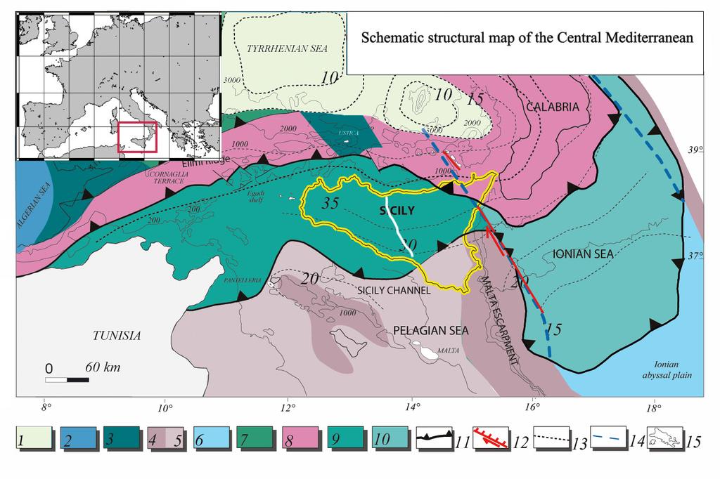
5 The study area-regional framework External Calabrian Arc
6 The study area-regional framework Main FTB Gela Thrust Wedge External Calabrian Arc


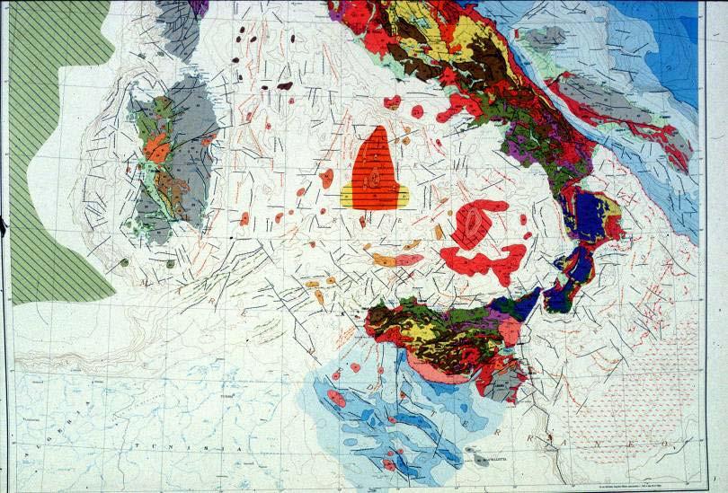
7 Imerese and Sicanian units are the Meso- Cenozoic deep water domains, the Trapanese- Saccense units represent the Meso- Cenozoic carbonate platform domains, as well the Iblean unit that is the foreland of the chain. European Tethyan African
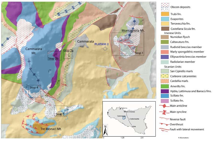
8 The study area concerns a sector located in central Sicily between the Madonie and Caltanissetta through. It covers the eastern Sicanian Mountains Geological map of central Sicily study sector crossed by SiRiPro seismic profile


9 Catalano et al., 2000 Top I-S Top Hy Previous papers have described the chain in Central-Western Sicily (Catalano et al., 1998, 2000) and Eastern Sicily (Bello et al., 2000) as formed from the bottom, by a stack of mesocenozoic carbonate platform ramp anticlines, deep water carbonate thrust sheets and clastic-evaporitic nappe wedge, lying above a believed not involved northward-dipping crystalline basement. Bello et al., 2000
10 Due to the poorly known structural and stratigraphic characters of the study area some questions arise: Is there a thrust pile structurally comparable to the western and eastern Sicily carbonate tectonic wedges? Are there carbonate platform units involved in the chain and what is their depth? - Are these units a local extension of the Pelagian-Iblean carbonate northward plunging foreland or a more internal carbonate platform thrust sheets? - Is the clastic and evaporitic Neogene sedimentary wedge covering the Caltanissetta through enough thin to be crossed by oil research boreholes?
11 Materials and methods To know more about the area, we performed: Detailed stratigraphy and field investigation Structural analysis Seismostratigraphic analysis of a dense grid of seismic reflection profiles Borehole calibration

12 A recent available stratigraphy of the area resultig from the integration of surface and borehole lithostratigraphy referred to the shallow and deepwater permian-mesozoic to tertiary palaeogeographic domains. These lithologies have been crossed by deep wells located in the study area


13 The boreholes main stratigraphic horizons have calibrated important seismic reflectors Thanks to ENI S.p.a. The new stratigraphy and the mesostructural analyses accomplished in the last years support with field data the joint interpretation of the confidential seismic lines acquired by ENI S.p.A. (Catalano et al., 2008, 2010)


14 These results are now calibrated by a crustal profile (SIRIPRO Project, leader R. Catalano) recently acquired across Sicily from the Tyrrhenian coast to the Sicily Channel

15 Main aim: To define the structural setting of the buried FTB in central Sicily we proceded: correlating the outcropping and buried carbonate units showing the structural relationships between shallow and deep water carbonate units recostructing pattern and timing of deformation proposing a kinematic model useful for exploration strategies.
16 correlating the outcropping and buried carbonate units Geological map of central Sicily study sector crossed by SiRiPro seismic profile


17 c correlating the outcropping and buried carbonate units Two main sections crossing the western Madonie Mts and the Valledolmo area show as the outcropping and buried thrust sheets correlate in facies stratigraphy (Imerese), thrust geometry and same south-westward vergency SW a NE SW NE b a b s (TWT)
18 correlating the outcropping and buried carbonate units Geological map of central Sicily study sector crossed by SiRiPro seismic profile
19
20 correlating the outcropping and buried carbonate units a s (T.W.T.) a b


21 correlating the outcropping and buried carbonate units a s (T.W.T.) a b b s (T.W.T.)
22 correlating the outcropping and buried carbonate units c a c a b


23 correlating the outcropping and buried carbonate units c a c a b
24 showing the structural relationships between shallow and deep water carbonate units NNW SSE s (TWT) Carbonate platform is characterized by mainly low frequency, high amplitude group of reflectors (green arrow). Its top is located at 3 to 4 s (T.W.T.) Km Deep water carbonates are high frequency, high to medium amplitude group of reflectors, 0.5 to 1 s/twt thick (light blue arrow), bounded by continuous reflectors that represent the top of the Cretaceous beds and the bottom of the upper Triassic strata Imerese and Sicanian units, after boreholes calibration.

 NNW I nner")
25 showing the structural relationships between shallow and deep water carbonate units SSE Km s (TWT) NNW I nner carbonate P lt

26 reconstructing pattern and timing of deformation two main tectonic events are envisaged; shallow-seated and deep-seated thrusts occurred during the Miocene-Quaternary time interval that deformed the sedimentary cover of the former continental margin. Meso-structural data highlights two main NW-SE and NE-SW trending folds and crosscutting relations pointing out the implaced shallow-seated and deep-seated units have respectively SW- and E-vergency An earlier phase of thrusting involved the Sicilide, the Numidian flysch and the deep-sea Imerese-Sicanian units (Middle-Upper Miocene). Following their emplacement, the deep seated thrust reactivation detached and deformed the buried carbonate platform; it implied re-imbrication and shortening into the overlying deep water carbonate units as well in the highest tertiary levels

27 reconstructing pattern and timing of deformation


28 SSW salt reconstructing pattern and timing of deformation The progressive activation of deep seated thrusts and back-thrusts occurred since the Pliocene, developing structural depressions enclosed between growing structural highs (Morello well). SW-wards migration of the depocentre implying syntectonic sedimentation due to a)tectonic uplift of the underlying thrust sheets b) sedimentary supply and subsidence Timing of deformation involving the underlying already stacked units is Pliocene-Quaternary NNE Tortonian s (T.W.T.)
 with")
29 reconstructing pattern and timing of deformation the former continental margin. The formation of the basins is due to the development od the deepseated thrusts (in our case carbonate platform units) with forelandand hinterland- verging structures.


30 proposing a kinematic model useful for exploration strategies Burdigalian-Langhian Calabrian U Sicilidi U Imerese U Sicanian U Platform U? Calabrian U Sicilidi U Upper Miocene Trapanese-Saccense U Iblean U Calabrian U Sicilidi U Plio-Pleistocene


31 proposing a kinematic model useful for exploration strategies.
32 Answers to the previous questions -The main results reveal the occurrence in central Sicily of a tectonic wedge comparable with the eastern and western structures - The carbonate platform units occur beneath a pile of deep-water carbonate thrust sheets at depth between four and seven km. -The deep-seated carbonate platform units appear detached from platform Domains (Trapanese-Saccense) internal to the Iblean platform. The latter appears to extend beneath, slightly deformed and thinning towards the Tyrrhenian Sea - The clastic, evaporitic and carbonatic Neogene to Quaternary tectonic wedge,occurring in the area, reachs thickness that may be locally crossed by wells

33 proposing a kinematic model useful for exploration strategies. Tortonian-Pliocene deposits Sicilide U. Numidian Flysch U. Upper Imerese U. Lower Imerese U. Structural sketch Sicanian U. Carbonate platform U. A thick thrust pile of deep water carbonates (Imerese and Sicanian) units rests on carbonate platform imbricates (Trapanese units), resulting from latest Miocene-Quaternary deformation Tertiary terrigenous units and Pleistocene syntectonic basins overlie the carbonate thrust stack The occurrence of a deep seated carbonate platform body, forming local structural highs, could be a new potential target for hydrocarbon opportunities in central Sicily
Controls on clastic systems in the Angoche basin, Mozambique: tectonics, contourites and petroleum systems
 P2-2-13 Controls on clastic systems in the Angoche basin, Mozambique: tectonics, contourites and petroleum systems Eva Hollebeek, Olivia Osicki, Duplo Kornpihl Schlumberger, London, UK Introduction Offshore
South Pyrenean foreland basin
 South Pyrenean foreland basin 1 7 South Pyrenean foreland basin 1 8 South-Pyrenean Foreland basin S N Fore-bulge deformation Piggy-back B. Thrust nappes Basement Vergés & al, 2002 decollement Syntectonic
Structural Geology of the Mountains
 Structural Geology of the Mountains Clinton R. Tippett Shell Canada Limited, Calgary, Alberta clinton.tippett@shell.ca INTRODUCTION The Southern Rocky Mountains of Canada (Figure 1) are made up of several
NATURAL ENVIRONMENT. Geophysics
 NATURAL ENVIRONMENT Geophysics Geodynamics Alpine, Carpathian and Dinaric mountain belts surround the Pannonian (Carpathian) Basin, of Neogene through Quaternary in age. The Cenozoic evolution of the Alpine-Pannonian
The Late Tertiary Deep-Water Siliciclastic System of the Levant Margin - An Emerging Play Offshore Israel*
 The Late Tertiary Deep-Water Siliciclastic System of the Levant Margin - An Emerging Play Offshore Israel* Michael A. Gardosh 1, Yehezkel Druckman 2 and Binyamin Buchbinder 2 Search and Discovery Article
Structural Styles and Geotectonic Elements in Northwestern Mississippi: Interpreted from Gravity, Magnetic, and Proprietary 2D Seismic Data
 Structural Styles and Geotectonic Elements in Northwestern Mississippi: Interpreted from Gravity, Magnetic, and Proprietary 2D Seismic Data Nick Loundagin 1 and Gary L. Kinsland 2 1 6573 W. Euclid Pl.,
Chapter 3. Geology & Tectonics
 Chapter 3 Geology & Tectonics 3.1 Geology The general geological features of Indonesia are shown in Figure 3.1. The basement formation is metamorphic and it is intruded with plutonic formations. They are
 Sedimentary Basin Analysis http://eqsun.geo.arizona.edu/geo5xx/geos517/ Sedimentary basins can be classified based on the type of plate motions (divergent, convergent), type of the lithosphere, distance
Orphan Basin, Offshore Newfoundland: New seismic data and hydrocarbon plays for a dormant Frontier Basin
 Orphan Basin, Offshore Newfoundland: New seismic data and hydrocarbon plays for a dormant Frontier Basin Jerry Smee* G&G Exploration Consulting, 301 400-3rd Avenue SW, Calgary, AB, T2P 4H2 Sam Nader, Paul
Hints of active deformation in the southern Adriatic foreland: Holocene tectonics along the Apulia offshore (Italy)
") Hints of active deformation in the southern Adriatic foreland: Holocene tectonics along the Apulia offshore (Italy) Domenico Ridente^, Umberto Fracassi*, Daniela Di Bucci, Fabio Trincardi^ ^ & Gianluca
Hints of active deformation in the southern Adriatic foreland: Holocene tectonics along the Apulia offshore (Italy) Domenico Ridente^, Umberto Fracassi*, Daniela Di Bucci, Fabio Trincardi^ ^ & Gianluca
Depositional Environments and Hydrocarbon Potential of Northern Ionian Sea
 Depositional Environments and Hydrocarbon Potential of Northern Ionian Sea Vasiliki Kosmidou George Makrodimitras Nick Papatheodorou Contents Area of Interest Studied Dataset Workflow SWIT and Paleolatitude
Ionian Sea and Margins: Recent Prospections and Interpretations
 Ionian Sea and Margins: Recent Prospections and Interpretations Liliana Minelli co-authors: Faccenna C., Casero P. Dipartimento Scienze Geologiche Università Roma Tre 9th Offshore Mediterranean Conference
PETROLEUM GEOSCIENCES GEOLOGY OR GEOPHYSICS MAJOR
 PETROLEUM GEOSCIENCES GEOLOGY OR GEOPHYSICS MAJOR APPLIED GRADUATE STUDIES Geology Geophysics GEO1 Introduction to the petroleum geosciences GEO2 Seismic methods GEO3 Multi-scale geological analysis GEO4
of mud volcanoes: evidence of tectonic control
 Morphometric, geodetic and geophysical surveys of mud volcanoes: evidence of tectonic control in the Sicilian collisional belt G. De Guidi 1, F. Carnemolla 1, G. Barreca 1, F. Brighenti 1, C. Monaco 1,
Seismic Stratigraphy of the Fang Basin, Chiang Mai, Thailand Rungsun Nuntajun
 Chiang Mai J. Sci. 2009; 36(1) 77 Chiang Mai J. Sci. 2009; 36(1) : 77-82 www.science.cmu.ac.th/journal-science/josci.html Contributed Paper Seismic Stratigraphy of the Fang Basin, Chiang Mai, Thailand
EGAS. Ministry of Petroleum
 EGAS Ministry of Petroleum EGAS Ministry of Petroleum About The Block Location: N. El Arish offshore block is located in the extreme eastern part of the Egypt s economic water border and bounded from the
EGAS. Ministry of Petroleum
 EGAS Ministry of Petroleum EGAS Ministry of Petroleum About The Block Location: N. Thekah offshore block is located at about 56 km to the north of the Mediterranean shore line, 85 km to the north west
Seismic stratigraphy, some examples from Indian Ocean, interpretation of reflection data in interactive mode
 Seismic stratigraphy, some examples from Indian Ocean, interpretation of reflection data in interactive mode K. S. Krishna National Institute of Oceanography, Dona Paula, Goa-403 004. krishna@nio.org Seismic
F.H. NADER 1, PETROLEUM SYSTEMS MODELING CHALLENGES OF STRUCTURALLY COMPLEX FRONTIER BASINS: THE CASE OF THE LEVANT (EAST-MED) BASIN
 BASIN") PETROLEUM SYSTEMS MODELING CHALLENGES OF STRUCTURALLY COMPLEX FRONTIER BASINS: THE CASE OF THE LEVANT (EAST-MED) BASIN A PROPOSED INTEGRATED APPROACH F.H. NADER 1, J. Barabasch 2, L. Inati 1, M. Ducros
PETROLEUM SYSTEMS MODELING CHALLENGES OF STRUCTURALLY COMPLEX FRONTIER BASINS: THE CASE OF THE LEVANT (EAST-MED) BASIN A PROPOSED INTEGRATED APPROACH F.H. NADER 1, J. Barabasch 2, L. Inati 1, M. Ducros
entered a rapid development phase. Annual increased proven reserves are above 500 billion cubic meters (bcm) from 2003, and annual natural gas product
 from 2003, and annual natural gas product") (), entered a rapid development phase. Annual increased proven reserves are above 500 billion cubic meters (bcm) from 2003, and annual natural gas production has increased from 50bcm in 2000 to nearly
(), entered a rapid development phase. Annual increased proven reserves are above 500 billion cubic meters (bcm) from 2003, and annual natural gas production has increased from 50bcm in 2000 to nearly
Earth Science, (Tarbuck/Lutgens) Chapter 10: Mountain Building
 Chapter 10: Mountain Building") Earth Science, (Tarbuck/Lutgens) Chapter 10: Mountain Building 1) A(n) fault has little or no vertical movements of the two blocks. A) stick slip B) oblique slip C) strike slip D) dip slip 2) In a(n) fault,
Earth Science, (Tarbuck/Lutgens) Chapter 10: Mountain Building 1) A(n) fault has little or no vertical movements of the two blocks. A) stick slip B) oblique slip C) strike slip D) dip slip 2) In a(n) fault,
SEDIMENTARY BASINS BASIN TYPES ACCORDING TO TECTONIC. by Prof. Dr. Abbas Mansour
 SEDIMENTARY BASINS BASIN TYPES ACCORDING TO TECTONIC by Prof. Dr. Abbas Mansour B. Convergent plate margins 10. STABLE CONTINENTAL INTERIOR BASIN E.g. Lake Eyre Basin Intracratonic (= within stable continental
Reservoir Modelling of a Bioclastic Calcarenite Complex on Favignana, Southern Italy: The Application of Multi-point Statistics*
 Reservoir Modelling of a Bioclastic Calcarenite Complex on Favignana, Southern Italy: The Application of Multi-point Statistics* Robert Kil 1 and Andrea Moscariello 2,3 Search and Discovery Article #50548
Kilometre-Scale Uplift of the Early Cretaceous Rift Section, Camamu Basin, Offshore North-East Brazil*
 Kilometre-Scale Uplift of the Early Cretaceous Rift Section, Camamu Basin, Offshore North-East Brazil* Iain Scotchman 1 and Dario Chiossi 2 Search and Discovery Article #50183 (2009) Posted May 20, 2009
Sedimentary Cycle Best Practice: Potential Eo-Oligocene Sediments in Western Indonesia*
 Sedimentary Cycle Best Practice: Potential Eo-Oligocene Sediments in Western Indonesia* Mellinda Arisandy 1 and I Wayan Darma 1 Search and Discovery Article #11008 (2017)** Posted November 6, 2017 *Adapted
Case Study of the Structural and Depositional-Evolution Interpretation from Seismic Data*
 Case Study of the Structural and Depositional-Evolution Interpretation from Seismic Data* Yun Ling 1, Xiangyu Guo 1, Jixiang Lin 1, and Desheng Sun 1 Search and Discovery Article #20143 (2012) Posted April
Rock mechanics as a significant supplement for cross-section balancing (an example from the Pavlov Hills, Outer Western Carpathians, Czech Republic)
") Trabajos de Geología, Universidad de Oviedo, 30 : 140-144 (2010) Rock mechanics as a significant supplement for cross-section balancing (an example from the Pavlov Hills, Outer Western Carpathians, Czech
Trabajos de Geología, Universidad de Oviedo, 30 : 140-144 (2010) Rock mechanics as a significant supplement for cross-section balancing (an example from the Pavlov Hills, Outer Western Carpathians, Czech
Meandering Miocene Deep Sea Channel Systems Offshore Congo, West Africa
 Meandering Miocene Deep Sea Channel Systems Offshore Congo, West Africa S. Baer* (PGS), J. E. Comstock (PGS), K. Vrålstad (PGS), R. Borsato (PGS), M. Martin (PGS), J.P. Saba (SNPC), B. Débi-Obambé (SNPC)
APPENDIX C GEOLOGICAL CHANCE OF SUCCESS RYDER SCOTT COMPANY PETROLEUM CONSULTANTS
 APPENDIX C GEOLOGICAL CHANCE OF SUCCESS Page 2 The Geological Chance of Success is intended to evaluate the probability that a functioning petroleum system is in place for each prospective reservoir. The
This PDF file is subject to the following conditions and restrictions:
 Geological Society of America 3300 Penrose Place P.O. Box 9140 Boulder, CO 80301 (303) 447-2020 fax 303-357-1073 www.geosociety.org This PDF file is subject to the following conditions and restrictions:
Structure of the western Brooks Range fold and thrust belt, Arctic Alaska
 Trabajos de Geología, Universidad de Oviedo, 29 : 218-222 (2009) Structure of the western Brooks Range fold and thrust belt, Arctic Alaska J. DE VERA 1* AND K. MCCLAY 2 1Now at: Shell, Rijswijk, Netherlands.
MUHAMMAD S TAMANNAI, DOUGLAS WINSTONE, IAN DEIGHTON & PETER CONN, TGS Nopec Geological Products and Services, London, United Kingdom
 Geological and Geophysical Evaluation of Offshore Morondava Frontier Basin based on Satellite Gravity, Well and regional 2D Seismic Data Interpretation MUHAMMAD S TAMANNAI, DOUGLAS WINSTONE, IAN DEIGHTON
BALOCHISTAN FOLDBELT BASIN
 INTRODUCTION BALOCHISTAN FOLDBELT BASIN The Kharan-3 block is located in the Kharan Trough of Balochistan Basin. GEOLOGICAL SETTING The Balochistan Province is an Upper Cretaceous to Recent structurally
University of Leeds 3GP Geophysics Field Trip Lake Balaton, Hungary
 University of Leeds 3GP Geophysics Field Trip Lake Balaton, Hungary September 1-15, 2007 geological background and logistics Staff: Greg Houseman, Graham Stuart The Alpine-Carpathian-Pannonian System Elevation
Structural Style and Tectonic Evolution of the Nakhon Basin, Gulf of Thailand
 Structural Style and Tectonic Evolution of the Nakhon Basin, Gulf of Thailand Piyaphong Chenrai Petroleum Geoscience Program, Department of Geology, Faculty of Science, Chulalongkorn University, Bangkok
caribbean basins, tectonics and hydrocarbons university of texas institute for geophysics
 Copyright by Trevor John Aitken 2005 CENOZOIC STRATIGRAPHIC AND TECTONIC HISTORY OF THE GRENADA AND TOBAGO BASINS AS DETERMINED FROM MARINE SEISMIC DATA, WELLS, AND ONLAND GEOLOGY by Trevor John Aitken,
Blocks 31, 32, 33, 34, 35 & 36/03 Southeast Offshore Vietnam
 Blocks 31, 32, 33, 34, 35 & 36/03 Southeast Offshore Vietnam Block 31 32 33 34 35 36/03 Area (km 2) 5,036 4,440 4,630 4,700 4,630 2,950 Sea level (m) 20 20-30 30-40 50 50 50 Seismic 2D (km) 1,294 685 431
History of geology and research of the Jan Mayen Micro-Continent and its associated exploration risks.
 History of geology and research of the Jan Mayen Micro-Continent and its associated exploration risks. Anett Blischke, Iceland GeoSurvey Þórarinn S. Arnarson, Karl Gunnarsson, Iceland GeoSurvey The North-Dreki
Strike-Slip Faults. ! Fault motion is parallel to the strike of the fault.
 Strike-Slip Faults! Fault motion is parallel to the strike of the fault.! Usually vertical, no hanging-wall/footwall blocks.! Classified by the relative sense of motion. " Right lateral opposite block
SUPPLEMENTARY INFORMATION
 SUPPLEMENTARY INFORMATION Miocene drainage reversal of the Amazon River driven by plate-mantle interaction. Shephard, G.E., Müller, R.D., Liu, L., Gurnis, M. Supplementary Figures SOM Figure 1. Non-dimensional
The Mesozoic. Wednesday, November 30, 11
 The Mesozoic Periods of the Mesozoic Triassic- First period of the Mesozoic era Jurassic Cretaceous- Last period of the Mesozoic era Breakup of Pangaea Stage one (Triassic) Rifting and volcanism, normal
Southern Songkhla Basin, Gulf of Thailand
 Architecture and Depositional Environment of Fluvial Systems of Southern Songkhla Basin, Gulf of Thailand Toan Manh Do Petroleum Geoscience Program, Department of Geology, Faculty of Science, Chulalongkorn
Tectonic position of the sandstone Cenozoic Uranium Deposit of Bulgaria
 Tectonic position of the sandstone Cenozoic Uranium Deposit of Bulgaria Radoslav Nakov Geological Institute, Bulgarian Academy of Sciences Pirin Mountain view from Eleshnitsa Mine 2915 m Technical meeting
Copyright McGraw-Hill Education. All rights reserved. No reproduction or distribution without the prior written consent of McGraw-Hill Education
 Copyright McGraw-Hill Education. All rights reserved. No reproduction or distribution without the prior written consent of McGraw-Hill Education Tibetan Plateau and Himalaya -southern Asia 11.00.a VE 10X
PETROLEUM GEOLOGY OF THE RUSSIAN FAR-EAST
 Contents - 1 PETROLEUM GEOLOGY OF THE RUSSIAN FAR-EAST CONTENTS PART I: INTRODUCTION TO THE RUSSIAN FAR EAST AND ITS STRUCTURAL DEVELOPMENT. Chapter 1. The Russian Far East: Introduction and Infrastructure.
Fluvial-Estuarine and Deltaic Reservoirs, Shelf Margin Delta and Slope Reservoir Characteristics Philip Sedore 2015
 Fluvial-Estuarine and Deltaic Reservoirs, Shelf Margin Delta and Slope Reservoir Characteristics Philip Sedore 2015 Introduction The offshore Columbus Basin and the onshore Southern Basin of Trinidad are
For personal use only
 PNG Company Number 1-63551 Kina Petroleum Forward Exploration & Farmout Program in the Eastern and Western Papuan Basin December 2016 Slide 1 Kina s Assets straddle the stable Platform of the Western Papuan
Deep Seismic Profiling in the Tokyo Metropolitan Area for Strong Ground Motion Prediction
 Deep Seismic Profiling in the Tokyo Metropolitan Area for Strong Ground Motion Prediction Hiroshi Sato 1, Naoshi Hirata 1, Takaya Iwasaki 1, Kazuki Koketsu 1, Tanio Ito 2, Keiji Kasahara 3, Kiyoshi Ito
SEDIMENTARY BASINS Red Sea Coast of Egypt. by Prof. Dr. Abbas Mansour
 SEDIMENTARY BASINS Red Sea Coast of Egypt by Prof. Dr. Abbas Mansour Sedimentary basins Sedimentary basins are, in a very broad sense, all those areas in which sediments can accumulate to considerable
THERMAL MATURITY ASSESSMENT OF MIDDLE ROCKS AND HEAT FLOW MODELING IN AGATOVO-SUHINDOL AREA (CENTRAL NORTH BULGARIA)
") DOI: http://dx.doi.org/10.18509/agb.2015.01 UDC: 551.761:550.832.6.05(497.2) COBISS: THERMAL MATURITY ASSESSMENT OF MIDDLE TRIASSIC ROCKS AND HEAT FLOW MODELING IN AGATOVO-SUHINDOL AREA (CENTRAL NORTH
DOI: http://dx.doi.org/10.18509/agb.2015.01 UDC: 551.761:550.832.6.05(497.2) COBISS: THERMAL MATURITY ASSESSMENT OF MIDDLE TRIASSIC ROCKS AND HEAT FLOW MODELING IN AGATOVO-SUHINDOL AREA (CENTRAL NORTH
Kinematic inversion of pre-existing faults by wastewater injection-related induced seismicity: the Val d Agri oil field case study (Italy)
") Kinematic inversion of pre-existing faults by wastewater injection-related induced seismicity: the Val d Agri oil field case study (Italy) Buttinelli M., Improta L., Bagh S., Chiarabba C. 1/10 The Val
Kinematic inversion of pre-existing faults by wastewater injection-related induced seismicity: the Val d Agri oil field case study (Italy) Buttinelli M., Improta L., Bagh S., Chiarabba C. 1/10 The Val
Colombia s Offshore*
 PS A Seismic-Structural Interpretation, on the Identification of Possible Causes in the Formation of Gas Chimneys in Colombia s Offshore* Tatiana Mayorga 1, Andrés E. Calle 2, Freddy M. Niño 2, Jorge Rubiano
Israel: Seeing Deeper Imaging new play concepts with Clari-Fi broadband reprocessing
 Israel: Seeing Deeper Imaging new play concepts with Clari-Fi broadband reprocessing Alex Birch-Hawkins Interpretation Geophysicist 12 th December 2016 Contents TGS in Israel Geological Overview Exploration
Vail et al., 1977b. AAPG 1977 reprinted with permission of the AAPG whose permission is required for further use.
 Well 5 Well 4 Well 3 Well 2 Well 1 Vail et al., 1977b AAPG 1977 reprinted with permission of the AAPG whose permission is required for further use. Well 5 Well 4 Well 3 Well 2 Well 1 Vail et al., 1977b
A comparison of structural styles and prospectivity along the Atlantic margin from Senegal to Benin. Peter Conn*, Ian Deighton* & Dario Chisari*
 A comparison of structural styles and prospectivity along the Atlantic margin from Senegal to Benin Overview Peter Conn*, Ian Deighton* & Dario Chisari* * TGS, Millbank House, Surbiton, UK, KT6 6AP The
New insights on some structural geometries in Southern Apennines by multiscale analysis of potential fields
 New insights on some structural geometries in Southern Apennines by multiscale analysis of potential fields F. Cella ( 1 ), L. Ferranti ( 2 ), G. Florio ( 2 ) and L. Maschio ( 2 ) ( 1 ) Dipartimento di
RELINQUISHMENT REPORT. License P1546 Block April 2009
 RELINQUISHMENT REPORT License P1546 Block 110-01 14 April 2009 Sherritt International Oil and Gas Limited 2000, 425-1 st street S.W., Calgary, Alberta Canada T2P 3L8 Telephone (403) 260-2900 Fax (403)
Answers: Internal Processes and Structures (Isostasy)
") Answers: Internal Processes and Structures (Isostasy) 1. Analyse the adjustment of the crust to changes in loads associated with volcanism, mountain building, erosion, and glaciation by using the concept
Answers: Internal Processes and Structures (Isostasy) 1. Analyse the adjustment of the crust to changes in loads associated with volcanism, mountain building, erosion, and glaciation by using the concept
An International Journal of CHAPTER 1. The geology of Italy: a brief overview
 Per. Mineral. (2003), 72, SPECIAL ISSUE: Miocene to Recent..., 5-10 http://go.to/permin PERIOD! CO di MINERALOGIA established in 1930 An International Journal of MINERALOGY, CRYSTALLOGRAPHY, GEOCHEMISTRY,
Sequence Stratigraphy. Historical Perspective
 Sequence Stratigraphy Historical Perspective Sequence Stratigraphy Sequence Stratigraphy is the subdivision of sedimentary basin fills into genetic packages bounded by unconformities and their correlative
IRAQ. Target Exploration. Geodynamic Evolutions of The Sedimentary Basins of. This study is a major reference for Petroleum
 barr Target Exploration Target Exploration Geodynamic Evolutions of The Sedimentary Basins of IRAQ This study is a major reference for Petroleum Explorationists on the tectonics, stratigraphy, sedimentary
insu , version 1-25 Feb 2014
 Tectonophysics January 2014 V. 610 pp. 200-203 Author manuscript, published in "Tectonophysics 610 (2014) 200-203" DOI : 10.1016/j.tecto.2013.10.012 Reply to comment on the article Propagation of a lithospheric
Multiattributes and Seismic Interpretation of Offshore Exploratory Block in Bahrain A Case Study
 Multiattributes and Seismic Interpretation of Offshore Exploratory Block in Bahrain A Case Study Suresh Thampi, Aqeel Ahmed, Yahya Al-Ansari, Ali Shehab, Ahmed Fateh, Anindya Ghosh, Ghada Almoulani. The
Geologic Structures. Changes in the shape and/or orientation of rocks in response to applied stress
 Geologic Structures Changes in the shape and/or orientation of rocks in response to applied stress Figure 15.19 Can be as big as a breadbox Or much bigger than a breadbox Three basic types Fractures >>>
Block 43B - Onshore Oman
 Block 43B - Onshore Oman SUMMARY Block 43B is an 11,967 km 2 area located along the coastal area of Oman north of the Hajar Mountains. This is an unexplored region, both geographically and stratigraphically.
Earthquakes in Barcelonnette!
 Barcelonnette in the Ubaye valley : the landscape results of large deformations during the alpine orogene (40 5 Myr in this area) and the succession of Quaternary glaciations. The sedimentary rocks are
The Sierra Leone-Liberia Emerging Deepwater Province*
 The Sierra Leone-Liberia Emerging Deepwater Province* Joan F. Flinch 1, José L. Huedo 1, Hernán Verzi 1, Héctor González 1, Ricardo Gerster 1, Abdul K. Mansaray 1, L. P. Painuly 1, Leticia Rodriguez-Blanco
Search and Discovery Article #40536 (2010) Posted June 21, 2010
 Posted June 21, 2010") Modern Examples of Mass Transport Complexes, Debrite and Turbidite Associations: Geometry, Stratigraphic Relationships and Implications for Hydrocarbon Trap Development* Fabiano Gamberi 1, Marzia Rovere
Modern Examples of Mass Transport Complexes, Debrite and Turbidite Associations: Geometry, Stratigraphic Relationships and Implications for Hydrocarbon Trap Development* Fabiano Gamberi 1, Marzia Rovere
Supplementary Material
 GSA Data Repository item 2018118 Brardinoni, F., Picotti, V., Maraio, S., Paolo Bruno, P., Cucato, M., Morelli, C., and Mair, V., 2018, Postglacial evolution of a formerly glaciated valley: Reconstructing
Section 7. Reading the Geologic History of Your Community. What Do You See? Think About It. Investigate. Learning Outcomes
 Chapter 3 Minerals, Rocks, and Structures Section 7 Reading the Geologic History of Your Community What Do You See? Learning Outcomes In this section, you will Goals Text Learning Outcomes In this section,
Petroleum Potential of the Application Area L12-4
 Petroleum Potential of the Application Area L12-4 The Application Area (L12-4) is underlain by the western Officer Basin, beneath the Gunbarrel Basin. The general basin architecture is outlined in Figure
Evolution of Continents Chapter 20
 Evolution of Continents Chapter 20 Does not contain complete lecture notes. Mountain belts Orogenesis the processes that collectively produce a mountain belt Includes folding, thrust faulting, metamorphism,
Summary. Study Area. Data Acquisition
 Evidence for hyper-extended continental crust in the East Orphan Basin from seismic reflection data and potential field forward modelling and inversion J. Kim Welford 1, Deric Cameron 2, James Carter 2
The Sorong Fault Zone Kinematics: The Evidence of Divergence and Horsetail Structure at NW Bird's Head and Salawati Basin, West Papua, Indonesia*
 The Sorong Fault Zone Kinematics: The Evidence of Divergence and Horsetail Structure at NW Bird's Head and Salawati Basin, West Papua, Indonesia* Putri Riadini 1 and Benyamin Sapiie 2 Search and Discovery
Aegeis deep structure & slab rollback in the Mediterranean
 Aegeis deep structure & slab rollback in the Mediterranean A paper for the Naxos field trip with Prof. Dr. Janos Urai, Summer Term 2014 Caspar Sinn, Martin Schlemmer August 31st, 2014 RWTH Aachen University,
Imprints of Mesozoic-Paleozoic strata and Eocene Carbonates in J&K Sub-Himalaya : Potential Rocks for Hydrocarbon Exploration
 6 th International Conference & Exposition on Petroleum Geophysics Kolkata 2006 Imprints of Mesozoic-Paleozoic strata and Eocene Carbonates in J&K Sub-Himalaya : Potential Rocks for Hydrocarbon Exploration
Abstract. Introduction. Regional Setting. GCSSEPM to be published December 2003
 Shelf Margin Deltas and Associated Deepwater Deposits: Implications on Reservoir Distribution and Hydrocarbon Entrapment, Block VI-1, Ulleung Basin, East Sea, South Korea Sneider, John S. Sneider Exploration,
Mountains are then built by deforming crust: Deformation & Mountain Building. Mountains form where stresses are high!
 Deformation & Mountain Building Where are mountains located? Deformation and Folding Mountain building Mountains form where stresses are high! Mountains form at all three types of plate boundaries where
Serial Cross-Section Trishear Modeling: Reconstructing 3-D Kinematic Evolution of the Perdido Fold Belt*
 Serial Cross-Section Trishear Modeling: Reconstructing 3-D Kinematic Evolution of the Perdido Fold Belt* Dian He 1 and John Paul Brandenburg 2 Search and Discovery Article #30313 (2014)** Posted January
2.1. Central Indus Basin:
 14 2.1. Central Indus Basin: Research area lies in the Central Indus Basin of Pakistan. Central Indus Basin may be divided into following broad tectonic divisions from east to west (Kadri, 1995) (1) Punjab
Biostratigraphic and Lithostratigraphic Correlation of Sedimentary Strata in the Atlantic Coastal Plain
 Biostratigraphic and Lithostratigraphic Correlation of Sedimentary Strata in the Atlantic Coastal Plain Introduction to the Atlantic Coastal Plain (Please read this page prior to doing the lab) The Atlantic
Structural Style in the Peel Region, NWT and Yukon
 Structural Style in the Peel Region, NWT and Yukon Adriana Taborda* Husky Energy and University of Calgary, Calgary, AB Adriana.Taborda@huskyenergy.ca and Deborah Spratt University of Calgary, Calgary,
Petroleum geology framework, West Coast offshore region
 Petroleum geology framework, West Coast offshore region James W. Haggart* Geological Survey of Canada, Vancouver, BC jhaggart@nrcan.gc.ca James R. Dietrich Geological Survey of Canada, Calgary, AB and
A brief history of the Messinian on Sicily
 A brief history of the Messinian on Sicily Rob Butler The Salinity Crisis in the Mediterranean represents one of the most dramatic examples environmental change outside of glaciated areas in the relatively
Salt tectonic styles in the spreading basin: Yucatan, Offshore Mexico Purnima Bhowmik*, Rodolfo Hernandez and Katarina Rothe, TGS
 1 Purnima Bhowmik*, Rodolfo Hernandez and Katarina Rothe, TGS Summary The TGS Gigante project is comprised of 188,497 km of 2D seismic data acquired in 2016 and primarily covering the offshore Mexican
Topics Laramide Orogeny: Late Cretaceous to Early Eocene Reading: GSA DNAG volume 3, Ch. 6
 Topics Laramide Orogeny: Late Cretaceous to Early Eocene Reading: GSA DNAG volume 3, Ch. 6 Late Cretaceous to early Eocene New patterns developed 5 main regions Tectonic interpretations Post-Laramide events
Integrated Interpretation of Gravity, Magnetic & Seismic data for delineation of Basement Configuration in Sadiya Block, Upper Assam, India
 P-225 Integrated Interpretation of Gravity, Magnetic & Seismic data for delineation of Basement Summary G.K.Ghosh *, S.K.Basha, V.K. Kulshreshth Gravity and magnetic data were collected jointly by National
ANGOLA OFFSHORE LICENSING 2007 BLOCK 46
 AGOLA OFFHOR LICIG 2007 BLOCK 46 DATA BA AVAILABILITY Figure 1 shows the seismic data available on Block 46. Fig. 1 Commercial 2D surveys: esterngeco: 794 km. GX Technology: 116 km. Commercial 3D surveys:
Subduction Tectonics and its Gravity and Magnetic response in Andaman Sea
 P-342 Summary Subduction Tectonics and its Gravity and Magnetic response in Andaman Sea S.M. Chatterjee*, C.S. Bahuguna,, D. Saha, Kh. Nabakumar, D. Sar, and C.L. Baloni, Geophysics Division, KDMIPE, Oil
FINAL EXAM Crustal Deformation CONVERGE DIVERGENT PLATES MANTLE PLUMES FLUX BASALTIC GRANITIC
 Crustal Deformation Reading: Chapter 10 Pages 283-304 Review Questions 4, 6, 7, 10, 12, 15, 18, 20 FINAL EXAM NOON TO 2 PM, TUESDAY DEC. 5 HERE: Natural Science 101 BRING A SCAN TRON TURN IN YOUR REVIEW
Fourth Energy Summit Sustainable, competitive and secure energy in Europe. Avraam Zelilidis, Professor Department of Geology, University of Patras
 Fourth Energy Summit Sustainable, competitive and secure energy in Europe Monday 14 th November 2011, Nicosia Cyprus The status of energy exploration in Cyprus and its geostrategic significance for the
Fault History analysis in Move
 Fault History analysis in Move The new Fault History plot in Move provides a method to conduct a quick-look analysis of the evolution of faults through time. By restoring the vertical displacement of a
LOW ENTHALPY GEOTHERMAL RESERVOIR EXPLORATION IN THE APENNINES BURIED THRUST FRONT SOUTH OF PARMA
 LOW ENTHALPY GEOTHERMAL RESERVOIR EXPLORATION IN THE APENNINES BURIED THRUST FRONT SOUTH OF PARMA Geol. Molinari Fabio Carlo (1) Geol. Martelli Luca(1) Prof. Geol. Valloni Renzo (2) 1)Geological, Seismic
Depositional History and Petroleum Potential of Ombilin Basin, West Sumatra - Indonesia, Based on Surface Geological Data*
 Depositional History and Petroleum Potential of Ombilin Basin, West Sumatra - Indonesia, Based on Surface Geological Data* Yahdi Zaim 1, Litto Habrianta 2, Chalid I. Abdullah 1, Aswan 1, Yan Rizal 1, Nurcahyo
Structural Framework and Deep-Marine Depositional Environments of Miocene- Pleistocene Sequence in Western Offshore Myanmar
 P-58 Structural Framework and Deep-Marine Depositional Environments of Miocene- Pleistocene Sequence in Western Offshore Myanmar Mukesh Jain*, Prabal Shankar Das, Bidesh Bandyopadhyay Summary The western
L.K. Carr 1, R.J. Korsch 1, A.J. Mory 2, R.M. Hocking 2, S.K. Marshall 1, R.D. Costelloe 1, J. Holzschuh 1, J.L. Maher 1. Australia.
 STRUCTURAL AND STRATIGRAPHIC ARCHITECTURE OF WESTERN AUSTRALIA S FRONTIER ONSHORE SEDIMENTARY BASINS: THE WESTERN OFFICER AND SOUTHERN CARNARVON BASINS L.K. Carr 1, R.J. Korsch 1, A.J. Mory 2, R.M. Hocking
Comment on: Cenozoic evolution of the eastern Danish North Sea by M. Huuse, H. Lykke-Andersen and O. Michelsen, [Marine Geology 177, 243^269]
![Comment on: Cenozoic evolution of the eastern Danish North Sea by M. Huuse, H. Lykke-Andersen and O. Michelsen, [Marine Geology 177, 243^269]](/thumbs/93/112023617.jpg "Comment on: Cenozoic evolution of the eastern Danish North Sea by M. Huuse, H. Lykke-Andersen and O. Michelsen, [Marine Geology 177, 243^269]") Marine Geology 186 (2002) 571^575 Discussion Comment on: Cenozoic evolution of the eastern Danish North Sea by M. Huuse, H. Lykke-Andersen and O. Michelsen, [Marine Geology 177, 243^269] P. Japsen, T.
Marine Geology 186 (2002) 571^575 Discussion Comment on: Cenozoic evolution of the eastern Danish North Sea by M. Huuse, H. Lykke-Andersen and O. Michelsen, [Marine Geology 177, 243^269] P. Japsen, T.
29. IMPLICATIONS OF DEEP SEA DRILLING, SITES 186 AND 187 ON ISLAND ARC STRUCTURE
 29. IMPLICATIONS OF DEEP SEA DRILLING, SITES 186 AND 187 ON ISLAND ARC STRUCTURE John A. Grow 1, Marine Physical Laboratory, Scripps Institution of Oceanography, La Jolla, California INTRODUCTION Pacific
Airborne gravity gradiometer surveying of petroleum systems under Lake Tanganyika, Tanzania
 Airborne gravity gradiometer surveying of petroleum systems under Lake Tanganyika, Tanzania D. Roberts Beach Energy P. Roy Chowdhury CGG S. J. Lowe CGG A. N. Christensen CGG Outline Introduction Geology
Correlation of tectonic units from the Alps to Western Turkey
 Correlation of tectonic units from the Alps to Western Turkey Stefan M. Schmid (ETH Zürich) with Daniel Bernoulli, Bernhard Fügenschuh, Alexandre Kounov, Liviu Matenco, Roland Oberhänsli, Senecio Schefer,